Article

Submarine Geomorphology and Sedimentary Features around the Egadi Islands (Western Mediterranean Sea)

1
Department of Earth and Marine Sciences, University of Palermo, 90123 Palermo, Italy
2
CoNISMa Interuniversity Consortium on Marine Sciences, 00126 Roma, Italy
3
Marine Sciences Institute, CSIC, 08003 Barcelona, Spain
4
Fugro Italy S.p.A., 00126 Rome, Italy
5
Department of Chemical and Geological Sciences, University of Cagliari, 09042 Monserrato, Italy
*
Author to whom correspondence should be addressed.
J. Mar. Sci. Eng. 2023, 11(6), 1246; https://doi.org/10.3390/jmse11061246
Submission received: 18 April 2023 / Revised: 10 June 2023 / Accepted: 12 June 2023 / Published: 19 June 2023
(This article belongs to the Special Issue Marine Geological Mapping)

Abstract

:
In this paper, the physiography, geomorphological features, and sedimentary bedforms of the offshore Egadi Islands (Italy) have been illustrated and mapped through an integrated analysis of high-resolution bathymetric, seismo-acoustic, and sedimentological data. The study area is characterized by a wide, up to 25 km, continental shelf which is separated by a NNW-trending linear incision, the Marettimo Channel, along which several erosional and depositional features have been detected and mapped. Sedimentary prograding wedges were detected at water depths between 100–125 m along the shelf margin, which accumulated during the sea-level fall and lowstand stages of the last glacio-eustatic cycle (post- MIS 5.5). This study detected several slope breaks defining scarps across the continental shelf, which were interpreted as coastal cliffs that originated during the post-LGM eustatic sea-level rise. Several fields of different types of sedimentary bedforms, including 2-D and 3-D hydraulic dunes and sorted bedforms, were found across the continental shelf, providing evidence of a high hydrodynamic regime affecting the seafloor. Further on, this study recognized erosive and depositional features related to bottom currents (contourites) in the Marettimo Channel. These findings provide a better understanding of the morpho-sedimentary evolution of the Egadi Islands offshore in the latest Quaternary. Moreover, they offer essential scientific support for effectively managing the most valuable priority habitats for conservation, such as the Posidonia oceanica meadow and coralline algae bioconstructions (Coralligenous habitat).

1. Introduction

During the last glacio-eustatic cycle, which lasted for about 125,000 years, continental shelves around the globe experienced a significant and quite sudden environmental change. This change was due to a global drop in sea level, which led to the exposure of large marine areas to sub-aerial conditions. At the Last Glacial Maximum (LGM), which occurred about 20,000 years ago [1,2], the palaeo-sea level reached about 120–130 m below the current level. This was followed by a post-LGM eustatic rise that caused submersion of the exposed marine areas [3,4]. The sedimentary processes and morphogenesis of these areas were deeply influenced by this fluctuation, with continental, coastal, and marine environments subsequently established.
The study of the impacts of such environmental changes, and the reconstruction of the morpho-sedimentary evolution of continental shelf areas in the late Quaternary, rely on the integration of multiple acoustic methodologies that have significantly advanced in recent decades. The innovative multibeam methodology has greatly improved the ability to observe morphologies and bedforms of the seafloor and to measure their size more precisely than previous methods.
These studies have important implications for various scientific issues: identifying palaeo-bathymetric markers that can help constrain sea-level curves; linking the forecast scenarios of the expected eustatic rise’s impact on coasts to what happened during the recent geological past [5]; creating detailed geological maps of shallow seafloor areas that consider their physiographic, sedimentological, and geotechnical characteristics, as well as possible geohazards, to install infrastructures; and monitoring the extent and health of valuable natural habitats.
In this paper, we analyzed bathy-morphologic, seismo-acoustic, and sedimentologic data to explore the seafloor of the Egadi Islands, an archipelago located in the western Mediterranean Sea, off the coast of western Sicily (Figure 1). This area is characterized by a wide continental shelf and extensive valuable marine habitats, such as a marine phanerogame meadow and coralligenous bioconstruction. Previous studies have documented evidence of relevant sedimentary bedforms [6,7] and preserved, submerged, palaeo-coastal environments [8,9].
Among the latter, we have focused our attention on some specific morphologies; relict coastal cliffs bordered by shore platform, and nearshore submerged depositional terraces. Both these features can provide valuable information on the position reached by the shoreline following the sea-level change that has occurred since the LGM lowstand to present-day highstand, and thus they can potentially contribute to better define the trend of the sea-level curve itself. Indeed, according to Zecchin et al. (2015) [10], the morpho-genesis of submerged coastal cliffs bordered by a shore platform could be related to short episodes of acceleration in the rate of eustatic rise, lasting a few hundred years, caused by Arctic and/or Antarctic rapid ice melting, known as melt-water pulses (MWPs) [11,12,13].
Nearshore submerged depositional terraces are imaged on high resolution seismic profiles as seaward-steepening downlapping reflectors forming wedge-shaped prograding deposits which, in the Egadi Island offshore, are located along the continental shelf margin. Since the 1990s, following the technological improvement of high-resolution seismic reflection methodology, submerged depositional terraces have been extensively observed along continental shelf margin around the oceans and enclosed and semi-enclosed seas. The stratigraphic setting, progradational geometry and, where available, sedimentological properties of collected samples all suggest these seismic units can be interpreted as shallow water, coastal deposits which prograde seawards parallel to the shoreline [14,15,16]. When interpreted in the light of sequence stratigraphy models, the origin of the progradational deposits, currently located along the continental shelf margin, have been correlated to lowstands of middle–late Pleistocene glacio-eustatic changes [17]. According to more recent studies, based on a comparison between the shelf margin prograding wedges and their probable counterpart currently lying in the present-day infralittoral zone of wave-dominated coasts (Infralittoral Prograding Wedge, IPW) [18], these submerged depositional terraces develop under the combined action of storm waves and across-shore currents, which downwards transport littoral sediments, below the storm-wave base level. Since the late Holocene, modern IPWs accumulate at a water depth in between −10 and −50 m, depending on the hydrodynamic regime of the coastal zone [18,19]. Recently, Budillon et al. (2020) [20], by analysing a wide dataset of IPWs located in the central-eastern Tyrrhenian Sea, provide clues for the use of nearshore submerged depositional terraces as morphological proxies of past sea-level stands.
In the Egadi Archipelago, different indicators of relative sea-level changes have also been taken into account by other researchers. Antonioli et al. (2002) [21] have also illustrated the sea-level rise curve for the Holocene in NW Sicily by means of radiometric dating of submerged speleothems found offshore of Marettimo Island. The sea-level curve reconstructed by these authors is in good agreement with the predicted sea-level curves based on glacio-hydroisostatic models.
In the early 1990s, the Egadi Archipelago was selected by the Geological Survey of Italy (SGI) as a “prototypical geological sheet” to test investigation methods and cartographic representation for the survey of the marine portions of the “Geological Map of Italy” at a scale of 1:50,000 (Carg Project; www.isprambiente.gov.it, accessed on 18 March 2023). In this context, the following scientific contributions were made: Agnesi et al. (1993) [8] described and mapped the main geomorphological features of the Favignana–Levanzo sector and proposed an evolutionary scheme for the post-LGM geomorphological evolution; Colantoni et al. (1993) [6] illustrated the overall geomorphological setting of the Marettimo shelf and of the western sector of the Favignana shelf, and highlighted the properties and spatial distribution of sediment lying on the seabed; Agate et al. (1998) [22] presented a preliminary description of the latest Pleistocene–Holocene deposits submerged around Favignana Island; D’Angelo et al. (2004) [23] described in detail the geomorphological and seismostratigraphic characteristics of the progradational depositional system accumulated at the edge of the Favignana shelf during the most recent falling stage and lowstand (LGM) of the sea level; Lo Iacono (2004) [24] and Agate et al. (2005) [25], as an outcome of the GeBECSud Project (“Geological, bionomic and ecological study of protected marine areas of southern Italy”), illustrated the geomorphological, sedimentological, and bionomic features of the submerged coastal zone of Favignana, Levanzo, and Marettimo, providing useful observations for an analysis based on seascape ecology; and Agate et al. (2017) [26] illustrated the seismostratigraphic features of contourite drifts recognized along the Marettimo Channel. Recently, Lo Presti et al. (2019) [9] illustrated a detailed palaeogeographical reconstruction of the Egadi Archipelago since the LGM until Favignana and Levanzo became isolated. These authors used geomorphological, archaeological, and geophysical data to create a sea-level rise model. They also drew maps displaying the subsequent positions of the palaeo-shoreline during the post-LGM sea-level rise. The above-mentioned papers analyse specific features or illustrate the morpho-sedimentary characters of limited portions of the Egadi Archipelago. In this paper, thanks to the possibility of analysing and interpreting a complete bathy-morphological relief of the entire continental shelf of the Archipelago, we have set ourselves the following main goals: to recognize and map the main geomorphological and sedimentary features and to outline the most relevant morphogenetic and sedimentary processes that have shaped the seafloor during the latest Pleistocene–Holocene time interval.

2. General Setting

The study area, located in the western Sicily offshore (western Mediterranean Sea; Figure 1), belongs to the so-called Siculo–Tunisia platform, a wide shallow-water area extending between the Sicilian and Tunisian coasts [27]. The platform consists of two separated continental shelf sectors: the Adventure Bank to the south and the Egadi Archipelago to the north. Both sectors are characterized by a very low terrigenous sediment supply and intense hydrodynamic regimes [6].
The Egadi Archipelago comprises three main islands (Favignana, Levanzo, and Marettimo) and two minor islands: Maraone (0.05 km2) and Formica (0.04 km2). South of Favignana, Isola Lunga is a complex barrier-island which bounds a small coastal lagoon environment (Figure 2). In 1991, the Marine Protected Area (MPA) “Egadi Islands” was established to protect important benthic habitats such as the Posidonia oceanica prairie (extending over 12,536 hectares), the platform Coralligenous, and the trottoir of Vermetidi, originating from the cementification of the shells of the mollusc Dendropoma petraeum in association with calcareous algae. With an extension of 53,992 hectares, it is the largest MPA in the Mediterranean Sea (www.ampisoleegadi.it, accessed on 9 March 2023).
Meso-Cenozoic, deep, and shallow water carbonate and siliceous rocks crop out in the Egadi Islands [28,29,30] or are submerged and buried in the surrounding marine areas [31]. During the Middle Miocene to Early Pliocene time interval, these successions, formerly accumulated along the northern African continental margin, were shortened to form a tectonic stack over 15 km thick. This stack represents the westernmost outcropping segment of the Tertiary Sicilian fold and thrust belt and is east–southeast verging (Figure 3). The deformed Meso-Cenozoic rocks are unconformably overlaid by pelagic, emipelagic, and neritic-clastic deposits of Plio-Quaternary age [32,33]. In the Late Pliocene to Pleistocene, transpressive tectonics resulted in oblique lateral-slip faults along the NW–SE, NE–SO, N–S, and E–W directions [30,34,35], which influence the current coastline trend along some segments of the perimeter of the islands, especially at Levanzo and Marettimo. During the middle–late Quaternary, sea-level changes played a significant role in sedimentary and oceanographic processes, by changing the bathymetry and coastline position several times. Global sea levels began falling around 125 ka B.P. during the last glacioeustatic cycle [36], reaching its minimum (120–130 m) between 26,000 and 19,000 ka B.P. during the Last Glacial Maximum (LGM) [1]. Then, from about 18 ka B.P., the eustatic sea level began to rise to the present-day level [3,4].
The Egadi Islands’ coastal zone features scattered and relict deposits from the MIS 5.5 age located a few meters (0–9 m) above the current sea level [28,34,37]. This suggests that the Archipelago did not undergo significant vertical displacement during the post-MIS 5.5 time interval [21,38].
These major fluctuations in sea level indicate remarkable climatic variations and landscape changes. The temperature rise during the current interglacial period resulted in the expansion of tree cover, previously limited to mountain valleys. Subsequently, Sicily evolved towards a more arid climate influenced by the North African climate [39]. The present-day marine wave setting, as depicted by data recorded by a wave buoy located in the Sicily Channel off the Mazara del Vallo town (Figure 4), is characterized by an enhanced seasonal behaviour, with the most energetic winter storm events occurring from October to April. The longest fetch areas correspond to the western, north-western, and south-eastern sectors, from which NW and SE winds blow. The maximum significant wave height (Hs) and peak period (Tp) recorded values were 6.6 m and 12 s, respectively.
Figure 3. (A) Simplified structural map of the Egadi Archipelago and the adjacent western Sicily mainland where the main tectonic features are imaged (from Gasparo Morticelli, 2016 [30]). Compressive shortening affected the area almost during the latest Miocene–Early Pliocene time interval by means of east–southeast verging overthrusts. (B) Multichannel seismic profile across Marettimo Channel showing structural setting of the study area characterized by a stack of tectonic wedges. Legend: (A) deformed units of Sicilian–Maghrebian fold and thrust belt; (B) slightly deformed Miocene deposits; (C) Plio-Pleistocene deposits (modified from Sulli, 2000 [40]; see Figure 6 for location).
Jmse 11 01246 g003

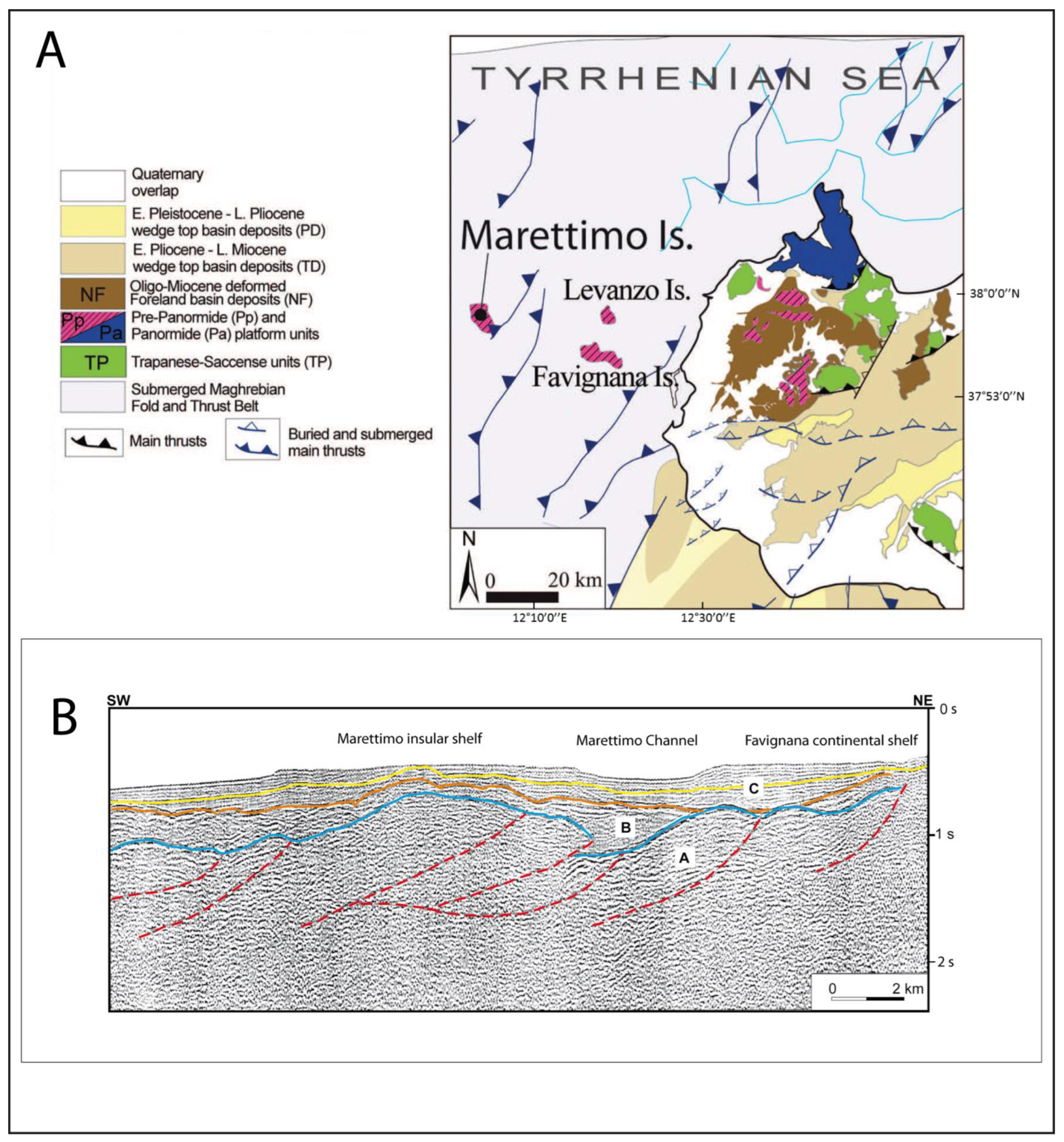
2.1. Physiographic Setting

The study area encompasses a continental shelf as well as upper continental slope sectors. There are two, separated, continental shelf sectors (Figure 2): the first sector extends off the western Sicily mainland and includes the Favignana and Levanzo Islands along with smaller islands such as Maraone, Formica, and Longa (from now on this sector will be referred to as the “continental shelf of Favignana”). The second sector is an isolated insular shelf surrounding the Marettimo Island. In the first sector, the maximum distance of the continental shelf break from the coastline is up to 26 km, while around the Marettimo Island, the continental shelf extends up to 12 km southward of the island. However, the shelf is very narrow off the other sides of the island, measuring only 2 km in the sector where the platform is the narrowest.
Along the continental slope surrounding the Marettimo insular shelf, the seafloor deepens down more than 1000 m water depth towards the Trapani Basin to the north and towards the Egadi Valley to the west (Figure 1). In the south, the shallow water seafloor connects the continental shelf sector where Egadi Islands are located to the Adventure Bank continental shelf (Figure 1).

2.2. Sedimentological Setting

The continental shelf features several outcrops composed of Meso-Cenozoic rocks, which form isolated reliefs of varying sizes [30,31]. These outcrops are separated by extensive areas with a slight slope, covered by a thin and discontinuous sediment drape overlaying an irregular and erosive rocky surface. The seabed samples indicate a hybrid sediment type, comprising lithoclastic calcareous or siliceous particles, as well as bioclastic grains (Figure 5 and Figure 6). These grains are derived from the degradation of biotic assemblages of coralligenous and pre-coralligenous facies and from skeletal materials of the marine organisms living in the phanerogamae prairies, such as Mollusca, Bryozoans, and benthic Foraminifera (24, 25). Deposits near the inner shelf are mostly sandy-to-gravelly, with a significant carbonate bioclastic fraction. At the foot of isolated reliefs, there are biogenic gravels consisting of red algae (maerl).
The sediment distribution of the area shows a “graded” trend, with a gradual decrease in the grain size towards the open sea (Figure 5). Gravel deposits can be found along the submerged coastal belt where boulders coming from cliff landslides (rock-fall) may also be present [24]. Biogenic gravelly sands and coarse sands are the most common sediments on the inner continental shelf, while fine-to-medium sands, silty sands, and sandy silts are prevalent across the outer shelf. The Marettimo and Favignana continental shelf display scattered outcrops of pre-Quaternary sedimentary bedrock at different depths across the distal sector. Silts and silty clays are distributed along the Marettimo Channel and the upper slope, while clays are present at deeper water depths along the upper slope [6].
Especially around the island of Favignana, a vast Posidonia oceanica prairie almost completely dominates the inner shelf at depths shallower than 40 m, extending over coarse grain sediment and bedrock outcrops. Additionally, the wall-coralligenous habitat covers many escarpments and isolated reliefs [41].

3. Data Set and Methods

We utilized a dataset from the Side Scan Sonar (Klein 3900) and Multibeam (Reson SeaBat 8125) surveys (Figure 6) to interpret the geomorphological and sedimentological features of the seabeds of the Egadi Islands. These surveys were conducted between 2019–2020 as part of the marine surveys by MPA “Egadi Islands” for monitoring the platform coralligenous habitat (Project “Marine Strategy”). The bathy-morphological data were integrated with the results of a Multibeam survey performed in 2001 with a Multibeam echosounder (Reson SeaBat 8111). The sedimentary characters of the seafloor were interpreted based on the calibration of Side Scan Sonar images and texture analysis performed on 166 samples (Figure 6) taken with a Van Veen grab in 1990 by the Italian Geological Survey. Additionally, data from point sampling performed during scuba diving, previously published by Agnesi et al., (1993) [8], Lo Iacono (2004) [25], and Agate et al., (2005) [25], were also considered. Furthermore, sub-bottom chirp 2–7 kHz acoustic profiles and single-channel reflection seismic profiles (Sparker 1, 4, 16 kJ) obtained during earlier research projects, as well as multichannel reflection seismic profiles (Airgun, Acquapulse) available on the VI.DE.PI Project website (Visibility of petroleum exploration data in Italy, www.videpi.com, accessed on 6 October 2022), were examined (Figure 6).
The bathy-morphological data collected through the Multibeam survey were processed to obtain a GRID and to return a Digital Elevation Model (DEM). The DEM was then used to analyse geomorphological and sedimentary features and to perform morphometric measures of the seabed. Side Scan Sonar sonograms were utilized to map the distribution of different seafloor sediments or rocks, which were previously calibrated using grab samples, a remotely operated vehicle (R.O.V.), and scuba-diving images.

4. Results

4.1. Continental Slope Geomorphology

The Favignana continental shelf and Marettimo insular shelf are separated by an elongated, NNW–SSE trending, bathymetric low, called Marettimo Channel. This channel crosses the upper slope and deepens toward the NNW from a minimum depth of −145 m (Figure 2 and Figure 7). As we move northwards, the channel becomes wider and splits into two distinct stretches after the isolated morphological high, called Banco Marettimo, whose top is about −100 m deep. Both stretches of the channel deepen towards the Trapani Basin (Figure 1), with water depths greater than −400 m.
The Marettimo Channel is characterized by steep sidewalls, with slopes that can reach 20° in some areas. The eastern sidewall runs parallel to the Favignana continental shelf and is oriented NNW–SSE. Meanwhile, the western flank is the boundary of the Marettimo insular shelf, with a NW-SE orientation in the northern sector and a NE–SW orientation in the southern sector. The upper slope of the southern sector features small gullies that scour and indent the edge of the Marettimo insular shelf (1 in Figure 7 and Figure 8a).
The following geomorphological features have been detected along the Marettimo Channell (Figure 7):
-
Two E–W oriented thresholds, approximately 1 km long, likely composed of a bedrock outcrop, and flanked by narrow elongated incisions about ten meters deep (2 and 3 in Figure 7); the southernmost threshold, situated in the narrowest part of the valley (about 2 km), has its top at a water depth of −180 m, while the northernmost threshold is at a depth of 235 m;
-
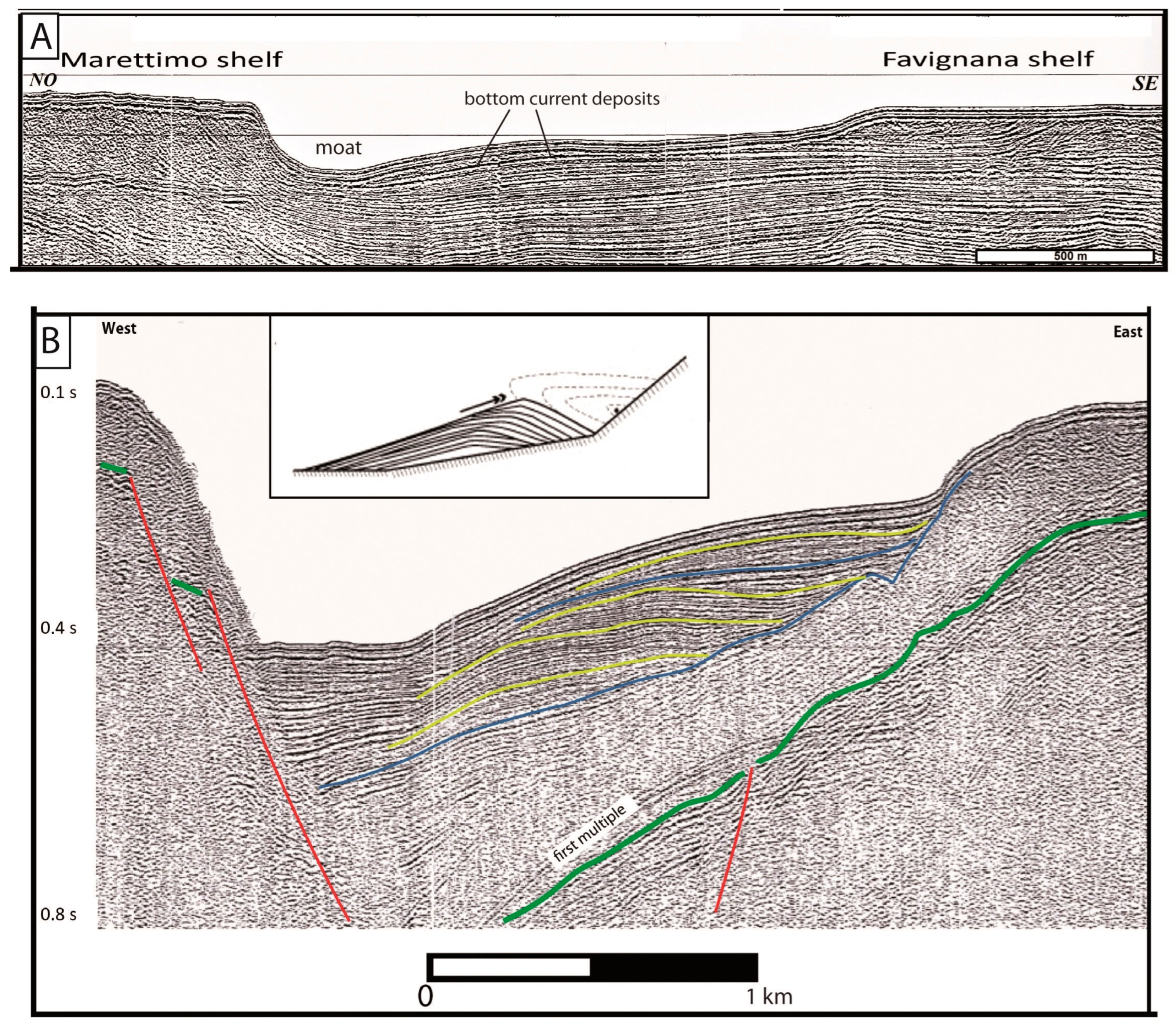
At a depth of approximately −370 m, there is a 2.5 km2 wide ellipsoidal blind bathymetric low, more than 50 m deeper than the surrounding seafloor (4 in Figure 7);
-
A NW–SE trending 4 km long scour, up to 15 m deep at approximately −350 m water depth (5 in Figure 7);
-
Marine terraces, some of which are several hundred meters wide, are found along the eastern flank of the Channel at a water depth of 140–150 m for the northern one (6 in Figure 7) and 105–120 m for the southern one (see Figure 6 for location);
-
Between 160–330 m water depth, a cluster of small WNW–ESE trending elongated morphological reliefs, a few meters elevated above the surrounding seafloor, and flanked by segmented narrow scours (7 in Figure 7);
-
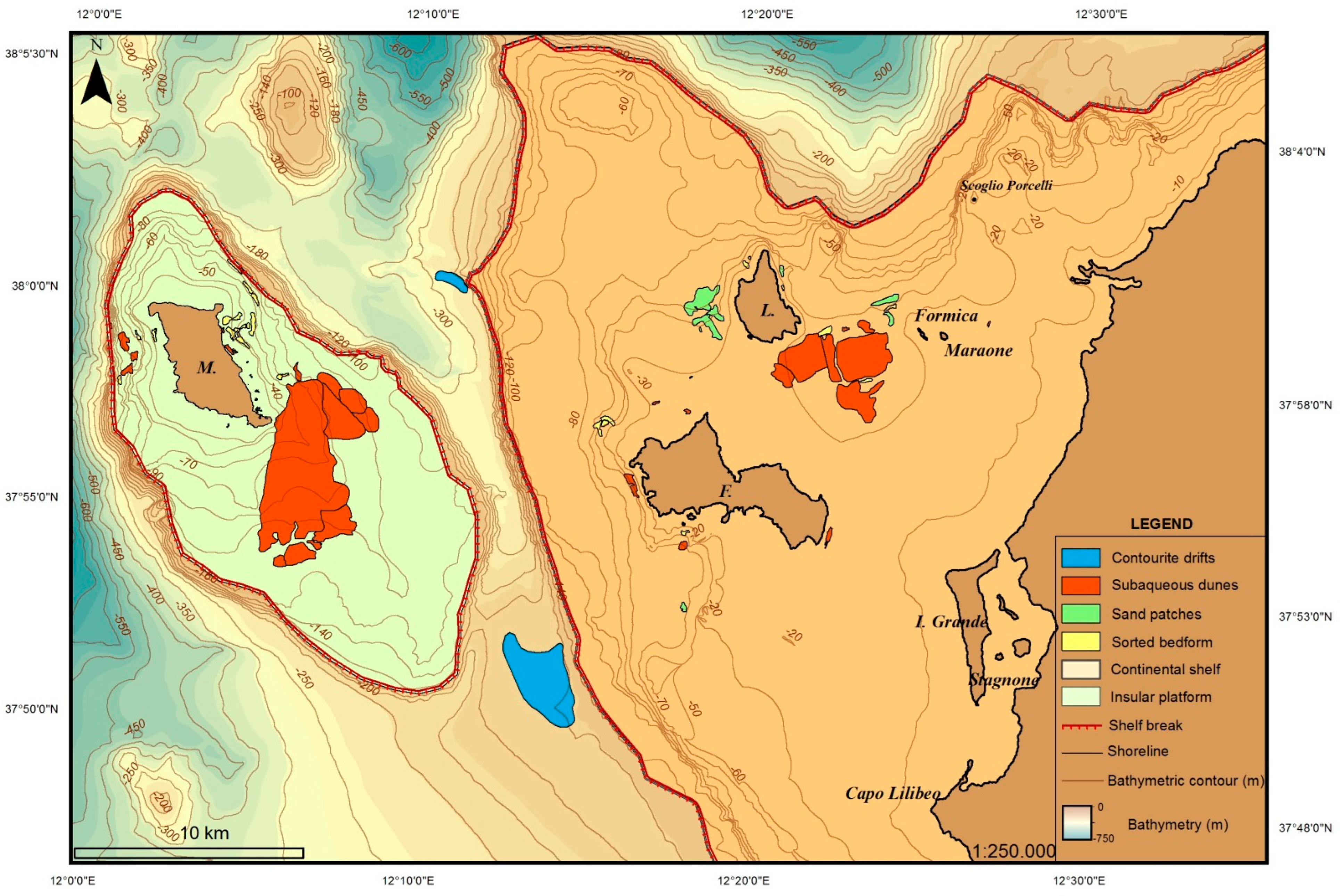
An area of about 6 km between the Marettimo insular shelf and the Banco Marettimo is covered by scattered boulders interpreted as landslide deposits originating from the western flank of the Marettimo Channel (8 in Figure 7). These individual blocs are up to a few meters high on the adjacent seafloor (Figure 8b).
There are several other notable geomorphological features that impact the upper slope seafloor in the Marettimo Channel. These include an erosive scour that borders the southern edge of the Marettimo insular shelf, which is 6 km in length, up to 20 m deep, and up to 1.6 km in width (9 in Figure 7). Additionally, there is an erosive linear incision that is oriented east–west, and deepens towards the west, scouring the upper slope seabed from a depth of 280 m to 550 m. This feature is located southwest of the Marettimo insular shelf (see Figure 6 for location).

4.2. Continental Shelf Geomorphology

The shelf break is the main, laterally continuous break in the slope of the seabed, which separates a sector of the seabed closer to the coast (the continental shelf), where the average slope generally does not exceed 2° of inclination, from a more distal sector (continental slope), where the average slope of the seabed is about 4° with locally high slopes up to 35° [42]. Off the Egadi Islands, the shelf break was recognized at depths between 110 and 130 m around the islands of Favignana and Levanzo, and between 95 and 135 m around the island of Marettimo (Figure 9). Canyon heads indenting the shelf break have not been detected. For long stretches, the shelf break forms in correspondence with net topographic convexity that came into shape on the pre-Calabrian bedrock. In other stretches, the shelf break has a depositional origin; indeed, it coincides with the offlap break of the late-Pleistocene prograding deposits accumulated across the edge of the continental shelf during the falling and lowstand stages of the eustatic level, at the height of the last glaciation (LGM, about 26–19 ka B.P.; Figure 10).
The progradational margin of the eastern flank of the Marettimo Valley, towards the south of Favignana Island, is highly developed; across this shelf margin, seismic profiles image a stack of sedimentary prograding wedges showing oblique-tangential to sigmoidal clinoforms up to 25–30 m high (Figure 10) [23]. The upper boundary of the prograding wedges is a sharp erosional surface related to the post-LGM sea-level rise [22]. As a result, this section of the shelf margin boasts a marine terrace that can stretch up to 2 km in width (Figure 9 for location).
The Favignana continental shelf displays an uneven seabed with very restricted flat areas, bounded by some meters-high escarpments and where scattered isolated reliefs have been detected, among which the most prominent are (Figure 9):
  • A 4.5 km long slope break detected south of Favignana Island at water depth of 45–57 m; the escarpment is up to 25 m high with the top, the Secca del Toro, only 10 m deep (Figure 11). Along the escarpment, Miocene, shallow water, bioclastic rocks have been recovered [8]. In the highest sector of the escarpment, a possible extensional trench can be observed, and, at the bottom of the rocky cliff, the seabed is covered by scattered large sub-angular boulders of multi-decametric dimensions, interpreted as rockfall deposits. Westwards of this escarpment, a topographically flat area is located, about 12 km2 wide, where the seabed lies down to 76 m deep.
  • A NW–SE trending, elongated relief north off Favignana Island, extending up from a 65–70 m deep seabottom, with the top (named Secca di Mezzo) at −18 m of water depth (Figure 12); southward, this isolated relief is bounded by an up to 15 m high escarpment marked, at the bottom, by an enhanced break-in-slope developing in between 43–50 m water depth;
  • NE of the Levanzo island, an isolated relief rising from a seafloor 55 m deep and with the top (named Secca di Levanzo; Figure 13) at 22 m water depth, along the southern boundary is bounded by an up to 5 m high subvertical cliff;
  • Eastward off Levanzo Island and southward of Secca di Levanzo, two ca 1.5 km long, a few meters high escarpments facing each other bound a flat area, 50–70 m deep, 200–500 m wide, elongated in a NNW-SSE direction (see Figure 9 for location); the direction of these escarpments is parallel to tectonic lineaments outcropping in the Levanzo Island;
  • Another less high but longer escarpment has been detected off SW Levanzo Island: it is more than 2 km long, NNW–SSE trending, and more than 10 m high (Secca di Deli; Figure 14); the bottom slope break lies at 35–50 water depth plunging southwards.
Very narrow, restricted, flat-strips of the seabed have been observed at the bottom of these escarpments (see bathymetric profiles in Figure 10, Figure 11, Figure 12 and Figure 13), that have been interpreted as “shore platforms”, sensu Bird (2000) [43].
The average slope gradient on the Marettimo insular shelf is 0.5°, with scattered isolated reliefs that are a few meters high. A sub-circular bathymetric low measuring 1 km wide and 12 m deep has been observed on the eastern shelf margin (Figure 7). The southern sector of the shelf, at 63–100 m water depth, features several submerged escarpments that are up to 10 m high and 1 km long.
The inner continental shelf boasts a highly irregular seafloor with small isolated topographic reliefs, blind depressions, and shallow linear incisions. Additionally, the presence of seagrass meadow extensively covers the seabed, making it difficult to observe the morphology using seismo-acoustic data.
The Egadi Islands are dominated by high rocky coasts, with the western coast of Marettimo Island characterized by the highest cliffs (up to 40 m) exposed to NW waves. During extreme meteo-marine events, these waves can reach heights of over 5 m (Figure 4).

4.3. Sedimentary Bedforms

A wide variety of depositional sedimentary structures have been detected across the continental shelf and the upper slope offshore Egadi Islands. Subaqueous bedforms include 2D and 3D hydraulic dunes (sensu [44]) and sorted bedforms that are longitudinal or transverse compared to the direction of the hydraulic flow. These bedforms are present at depths down to −100 m and are clustered in fields of varying sizes, ranging from 0.05 and 10 km2 (Figure 15). Additionally, both depositional (Figure 15) and erosional (5 and 9 in Figure 7) contouritic features have been surveyed along the Marettimo Channel.
A very wide (5 km2) dune field, has been recognized over the sector between the islands of Favignana, Levanzo, and Maraone at water depths between −40 and −50 m (Figure 15 and Figure 16). This field is composed of 3D hydraulic dunes arranged on elongated rows in a WNW–ESE direction slightly curved with the concavity facing NNE; the crest-to-crest spacing ranges from 40 to 60 m with an amplitude of 50 cm on average but exceeding in some cases even 80 cm and, in a few cases, reaching a meter; the largest are found in a small cluster of dunes located at the southern end of the field. Both dunes with a symmetrical transverse profile as well as dunes with an asymmetric transverse profile have been observed in the field (Figure 16). The direction of the mean flow is NNE–SSW, according to the general arrangement of the dune crests. Seafloor samples collected from this sector reveal the bottom sediments are sands. Considering morphology, morphometric parameters, sediment size and composition, this type of large bedforms are indicative of high availability of sandy sediments and could be generated by bottom currents with speed of 70–100 cm/s [45,46].
Another large field of underwater dunes is located south-east of the island of Marettimo off Punta Bassano (Figure 15), previously reported by Colantoni et al. (1993) [6]. The field spans a wide area about 10 km2 large and extends in water depth ranging from −45 to −75 m (Figure 17). The bedforms here present are made up of 2D dunes with lengths between 10 and 25 m and heights between 20 and 50 cm (Figure 17); they display a general NNE–SSW crest alignment slightly curved with the concavity facing NW.
Several bedform fields with a limited extent have been observed in the vicinity of all the islands (Figure 15). Of particular interest, because of the size of the involved sediments, are those observed around the island of Marettimo where, coarse grained sandy and gravelly sediments are involved in the formation of hydraulic dunes and sorted bedforms [7]. On the inner shelf of Marettimo Island, the dunes are distributed in a patchy pattern in a depth range of 10–50 m; they are composed of coarse sands, gravels, and pebbles, displaying a symmetrical shape with a wavelength in between of 1–2.5 m and a height of 0.15–0.30 m. Off the eastern coast of Marettimo Island, in the 15–50 m depth range, linear sorted bedforms, alternately in relief and in depression, are elongated almost perpendicular to the coast.
The eastern coast of Favignana Island hosts a small (0.1 kmq) subaqueous dune field situated in very shallow waters (10–15 m; Figure 18). The field comprises 2D dunes, 50 m long and up to 2 m high, with transverse orientation to the coast.
Off the western Levanzo Island coast, some minor sorted bedforms are related to a peculiar, very confined morphological setting (Figure 14b) defined by two elongated, parallel topographic reliefs.

4.4. Contouritic Features

The Marettimo Channel is home to various erosional morphologies and sedimentary accumulations (Figure 7 and Figure 15), which are a result of sedimentary transport through bottom currents. On the eastern flank of the Channel, two distinct sedimentary accumulations can be found, one in the south and the other in the north. These accumulations have an external mound shape, internal geometry with slightly convex upward reflective horizons, and cover an area of approximately 15 sq. km each, with a thickness of 100–200 msms (Figure 19). Additionally, elongated furrows up to 7 km long, 10–30 m deep, and a couple of km wide can be seen (Figure 7), along with smaller moats scouring the seabed at the bottom of scattered morphological reliefs in the northern stretch of the Channel.

5. Discussion and Conclusions

5.1. Physiography and Geomorphological Features

Our integrated analysis of seismoacustic and sedimentological data acquired along the seafloor off the Egadi Islands has revealed the existence of both erosional landforms and depositional bedforms in addition to features controlled by inherited structural settings located along the continental shelf-to-upper slope system. The inherited tectonic control on the current physiographic setting is more evident in the Marettimo insular shelf where tectonic structures partially control both shelf-edge and coastline trend.
Despite the enhanced water depth difference accommodated by the upper continental slope, especially towards the north and the west, the seafloor along the upper slope is almost devoid of relevant incisions generated by gravitational erosive flows, probably due to the very limited terrigenous sedimentary supply available in this area where sediments are almost authocthonous (biogenic and bioclastic).
The seismic profiles suggest that even the Marettimo Channel, the main elongated bathymetric low across the upper slope, is set in correspondence with a former structural low related to the thrusting of the Marettimo tectonic unit over the Favignana unit (Figure 3); furthermore, along the western flank of the channel, the seismic profiles also image later syn-sedimentary normal faults (Figure 19), suggesting that tectonic activity controlled the origin of this elongated bathymetric feature.
The main control on both erosive and depositional morphologies recognized across the continental shelf offshore to the Egadi Islands has been exercised by the middle–late Quaternary glacio-eustatic changes and especially by the last one, started since about 125,000 years B.P., during which the eustatic level dropped to about 120–130 m below the current level Siddall et al. (2003) [36].
Actually, considering that the Egadi Archipelago represents an area almost tectonically stable during the latest Pleistocene–Holocene time interval, the water depth (90–130 m) at which we detected discontinuous, relict, coastal deposits (= littoral prograding wedges; Figure 10; [22,23]) scattered across the present-day shelf margin, suggest that these depositional elements originated during the terminal stages of the last glacioeustatic falling to the LGM when global sea level was 120–130 below the present-day level (see Figure 20B). Therefore, the shelf edge was intensely shaped during this sea-level lowstand, assuming an enhanced convexity topography, by marine and sub-aerial erosive processes, along the rocky palaeo-coasts, and by depositional processes of sedimentary accumulation where today we find prograding sedimentary wedges that can be interpreted as possible palaeo-beaches. Across the continental shelf, only little evidence of relict palaeo-drainage has been detected. This feature could be relatable to the general physiographic setting of the area devoid of major topographical differences in elevation and of relevant mountain ranges in the surroundings.
Following the LGM lowstand stage, a main morphogenetic process, shaping the continental shelf seafloor during latest Pleistocene–Holocene sea-level rise, was the marine abrasion related to shoreline transgression; the latter produced both shoreface and cliff retreating along depositional and rocky coasts, respectively.
As consequence, a transgressive surface of erosion progressively developed across the continental shelf (Figure 10). According to Cattaneo and Steel (2003) [48], the erosion generated by this surface of formerly deposited sediments ranges in between a few meters to more than 10 m, depending on local environmental energy. Its geometry can be very irregular due to several factors, among which are the inherited palaeo-topography of the bedrock, the lateral variations in resistance of rocky substrate, and the variable wave energy settings [49,50,51]. In the Egadi Archipelago, this surface is very rough and marked by isolated reliefs and breaks-in-slope. These features can be flanked by escarpments that can be several meters or even decameters high. These escarpments are laterally continuous for many hundreds of meters, and, at their base, they are fronted by a narrow strip of flat seabed (e.g., Figure 11, Figure 12, Figure 13 and Figure 14). The characteristic morphology of this feature, consisting of an “escarpment-concave slope break-narrow flat basal surface”, suggests that it is representative of the coastal cliff–shore platform system. Their lateral disappearance could be related to lateral variation in wave erosion power and/or to inherited topography [52].
Figure 20. (A) Water depth range of slope breaks defining escarpments detected in the seafloor of the Egadi Archipelago. The yellow-colored squares represent the water-depth ranges of slope breaks defining escarpments recognized in the central Mediterranean Sea by Zecchin et al. (2015) [10]; also shown are the depths of the record of MWPs 1A and 1B recognized by Maselli et al. (2011) [53] in the Adriatic Sea. (B) Chart showing the current water depth of palaeo-coastal deposits and slope-break defining escarpments detected across the Egadi Islands continental shelf, plotted on the relative sea-level prediction curve proposed by Lambeck et al. (2014) [3].
Jmse 11 01246 g020
The morphological evolution of this system during relative sea-level rise is controlled by both marine wave abrasion and weathering processes [43].
Therefore, these currently submerged escarpments detected across the Egadi Archipelago continental shelf (previously illustrated in the section “Continental shelf geomorphology”) could have been shaped in a coastal environment during the last transgression, in occasion of slowdowns in the rise of the sea level, followed by phases of rapid rise. Indeed, in the presence of tenacious lithology such as carbonate rocks sampled in the escarpments of Secca del Toro, Secca di Mezzo, and Secca di Levanzo [8], the morphogenesis of the coastal cliff requires a relatively sea level still-stand for a period of time [43]; moreover, as proposed by Zecchin et al. (2011) [52], a subsequent rapid sea-level rise would promote the preservation of the cliff (according to the “cliff overstep” transgressive model).
Across the Egadi Islands offshore we have observed slope breaks defining escarpments at water depths of 65–70 and 95–100 m (south of Marettimo Island) and in the range of 38–65 m (Secca del Toro, Secca di Mezzo, Secca di Levanzo, Secca di Deli), that are correlatable to two depth ranges (40–65 m and 70–100 m) in which several slope breaks defining escarpments in the central Mediterranean shelves are clustered, taking into account local tectonics and glacio-hydro-isostatic effects [10]. Because these two depth ranges correspond to the depths at which the stratigraphic record of melt-water pulses (MWPs: rapid increases over short (decadal to centennial) timescales superimposed on a longer term rise of sea level, occurred during the deglaciation which followed the LGM; [11,12,13,54] have been recovered on the Adriatic shelf [10,53], we can infer that the slope breaks defining escarpments detected across the Egadi Islands offshore could represent remnants of palaeo-coastal cliffs that had been drowned during the MWP-1A, the deeper ones, and during the MWP-1B, the shallower ones (Figure 20A)
Moreover, taking into account that the Egadi Islands have been an almost tectonically stable areas since almost MIS 5.5, and thus assuming that the current depths of the seabed are solely the result of the post-LGM eustatic rise, using the sea-level curve returned by Lambeck et al. (2014) [3] for the central Mediterranean Sea, it turns out that the age corresponding to water depths at which we find the shallower concave slope-break of the interpreted paleo-cliffs fits to about the age of the MWP 1B (Figure 20B). In any case, further studies will be needed to better understand the contribution that these submerged morphologies can actually make to the reconstruction of sea-level curves. In the specific case of the Egadi Islands, it will also be necessary to take into account the anomalies of the curve of the sea level reconstructed for this area by Antonioli et al. (2002) [21] when compared to other areas.

5.2. Sedimentary Bedforms

Size, morphometric parameters, and water depth of the above illustrated series of bedforms detected across the continental shelf (see section “Sedimentary bedforms”) do not differ from those found on other Mediterranean or oceanic continental shelves where, to justify the formation of such structures, bottom current velocities of the order of 70–100 cm/s are estimated [45,46]. Actually, very strong subaqueous currents are reported by local fishermen and scuba divers in the Egadi Archipelago, and to explain the genesis of bedforms detected around Marettimo Island, Lo Iacono and Guillen (2008) [7] calculate a velocity of the bottom currents of order of 100 cm/s taking into account both water depth and size of the sediments.
Distribution, water depth, size, and direction of the various, surveyed dune fields are very varied (Table 1), suggesting a highly articulated pattern of circulation of bottom currents. For the structures observed around the island of Marettimo, given their symmetrical shape and orientation mostly parallel to the coast, Lo Iacono and Guillen (2008) [7] hypothesize an origin linked to storm waves, invoking, for the deepest bedforms, extreme events of even greater intensity than those recorded so far from the wave-buoy off Mazara del Vallo, the closest to the Egadi Islands (Figure 4). However, the new morpho-bathymetric surveys we have analysed show there are also dunes with an asymmetrical transverse profile, suggesting that unidirectional flows also contribute to the genesis of the bedforms laying in the seabed of the Egadi Islands; moreover, a dune field with crests arranged perpendicular to the coastline has been detected off east Favignana Island (Figure 18), concerning which, an enhanced longshore current could be taken into account as a possible origin. A more defined pathway of the circulation of the bottom currents across the Egadi Archipelago continental shelf can only be revealed by collecting more observations and measurements on the speed and directions of currents flowing on the seabed.
A very intense hydrodynamic regime must also be invoked to account for the contouritic morphologies and deposits detected along the Marettimo Channel. The Egadi Islands lie along the pathway of the Levantine Intermediate Water (LIW) [55] and it is possible that part of this flow, coming from the Sicily Channel, is channeled within the Marettimo Channel undergoing an acceleration that could be at the origin of the moats and sediment drifts that we observe in this area., Seismic profiles attest that erosional moats found south of Favignana erode the deposits of the latest Pleistocene lowstand (Figure 10 and Figure 19), suggesting that erosional flows of bottom currents post-date the LGM deposits, flowing within the Channel only after the eustatic level has begun to rise (actually, during the lowstand stage, the water depth inside the channel (<20 m at the shallowest level) would be too shallow to allow the passage of the LIW’s dense waters.

5.3. Morpho-Sedimentary Evolution

The result of our integrated submarine investigation allowed us to fix the main steps of the morfo-sedimentary evolution that has occurred in the Egadi Archipelago since the LGM until the present day.
The distribution of MIS 5.5 littoral deposits outcropping on the Egadi Island and located at the current coastline [28,30] suggests that, at that time, the paleogeography of the Archipelago was very similar to the current one. Since that time, and following the eustatic sea-level fall, the Egadi Island Archipelago obtained the maximum subaerial exposure when, about 20–18 kyr B.P. (LGM),the sea level was approximately 120–130 m below the present-day level, and the paleocoastline was located close to the current shelf break; at that time, the Favignana and Levanzo Islands were connected to mainland Sicily, originating two isolated hills, while the Marettimo Island was separated from the Sicily mainland by the Marettimo Channel that was narrower and shallower than now (Figure 21).
We have found evidence that high-rocky as well as low-depositional coasts developed at depth ranges in between 90–120 m during the LGM; rocky cliffs were located almost around the Marettimo paleoisland and along the northern sector of the Favignana shelf, while beaches originated almost in topographically depressed areas where sediments mostly accumulated (e.g., southward of Favignana Island).
During the post-LGM eustatic rise, a marine abrasion process related to shoreline transgression was extensive across the progressively enlarging continental shelf, erasing most of the morphologies formed during the previous subaerial emergence stage. As the sea level continued to rise, ephemeral islands originating from isolated reliefs were destined to be submerged (see also Figure 11 and Figure 12 in Lo Presti et al., 2019 [9]). During the short-lived stages of the slowing of this rise, the palaeo-cliffs fronted by a shore platform, that are now submerged in various places on the continental shelf, could have formed and been eventually preserved during the following events of a higher rate of sea-level rise, probably related to MWPs.
During sea-level rise, because of continuous changes in paleobathymetry and paleomorphology, local oceanographic conditions could also be very different from those of today, with very intense bottom flows at narrow, shallow passages and, at the present state of knowledge, we cannot entirely rule out the possibility that the various sedimentary structures observed on the seafloor of the continental shelf may have been generated by tractable currents consistent with paleobathymetry lower than the present day.
As the eustatic rise continued, the seafloor was covered by a thin carpet made up mostly by carbonate, autigenic sediment, promoted by the development of Posidonia oceanica biocenosis and the platform coralligenous habitat. Both were also able to take root and spread on these seabeds due to the favorable combination of the geomorphologic setting and hydrodynamic framework characterized by extensive areas of shallow water, enhanced local morphological articulation, reduced or null terrigenous sedimentary input, and high hydrodynamism.

6. Conclusive Remarks

The integrated analysis of newly recorded high resolution seismo-acoustic surveys and of a wide, “vintage”, dataset of seismo-acoustic and sedimentological data previously acquired, has allowed us to describe and map the geomorphological and sedimentological elements that characterize the seafloor around the Egadi Islands Archipelago. This study highlighted the widespread presence, both on the continental shelf and along the Marettimo Channel, of sedimentary structures that suggest the existence of intense bottom currents, which only in part can be interpreted as currents generated by storms. Relict depositional features along the shelf margin, as well as geomorphologic elements across the continental shelf, have been identified and mapped; both these features punctuate the shoreline’s migration, starting from the LGM and during the subsequent rise of the global sea level, and can contribute to better define the style and the rate of transgression. The study’s findings warrant further investigations to (i) reconstruct the pattern of bottom current circulation and (ii) understand the influence of the morpho-sedimentary setting and evolution on the distribution and conservation of priority habitats surrounding the Egadi Islands’ seafloor.

Author Contributions

Conceptualization, M.A., C.L., C.L.I. and A.S.; methodology, C.L., C.L.I. and S.P.; software, C.L., C.L.I. and S.P.; investigation, M.A., C.L., C.L.I., A.S., S.P. and P.E.O.; writing-original draft preparation, M.A. and C.L.; writing-review and editing, M.A., C.L., A.S. and R.C.; supervision, A.S.; funding acquisition, R.C. All authors have read and agreed to the published version of the manuscript.

Funding

This research is part of the scientific monitoring pursuant to art. 11 of Legislative Decree 190/2010—Marine Strategy—Implementation Protocol of the D.M. n. 24833 of 11 December 2015 in the “Egadi Islands” Marine Protected Area. Monitoring of the “coralligenous habitat” indicator and scientific support for the creation of a biocenotic cartography. CIG: 7360360936.

Institutional Review Board Statement

Not applicable.

Informed Consent Statement

Not applicable.

Data Availability Statement

Not applicable.

Acknowledgments

The authors wish to thank: the directors of the Egadi Islands MPA, S. Livreri Console, along with the entire Isole Egadi MPA personnel, for providing morpho-bathymetric data (SSS and Multibeam) mainly used in this paper and generous assistance during research activities; five anonymous Reviewers, whose numerous corrections and valuable suggestions have greatly improved the overall quality of the manuscript; the Geological Service of Italy, and in particular S. D’Angelo, for having made available many of the data illustrated in this paper and for having involved some of the Authors in the oceanographic cruises carried out in the early nineties for the survey of the Geological Sheet n° 604 “Egadi Islands”;—the masters and crews of the scientific vessels of the CNR (Bannok, Urania, Tethys) on board which most of the oceanographic cruises took place. Finally, we wish to address a special thanks to Raimondo Catalano who, with inexhaustible curiosity and enthusiasm, initiated some of the Authors to the geological exploration of the fascinating depths of the Egadi Islands.

Conflicts of Interest

The authors declare no conflict of interest.

References

  1. Clark, P.U.; Dyke, A.S.; Shakun, J.D.; Carlson, A.E.; Clark, J.; Wohlfarth, B.; Mitrovica, J.X.; Hostetler, S.W.; McCabe, A.M. The Last Glacial Maximum. Science 2009, 325, 710–714. [Google Scholar] [CrossRef] [Green Version]
  2. Peltier, W.R.; Fairbanks, R.G. Global glacial ice volume and Last Glacial Maximum duration from an extended Barbados sea level record. Quat. Sci. Rev. 2006, 25, 3322–3337. [Google Scholar] [CrossRef]
  3. Lambeck, K.; Rouby, H.; Purcell, A.; Sun, Y.; Sambridge, M. Sea level and global ice volumes from the Last Glacial Maximum to the Holocene. Proc. Natl. Acad. Sci. USA 2014, 111, 15296–15303. [Google Scholar] [CrossRef] [PubMed] [Green Version]
  4. Peltier, W.R.; Argus, D.F.; Drummond, R. Space geodesy constrains ice age terminal deglaciation: The global ICE-6G_C (VM5a) model. J. Geophys. Res.−Solid Earth 2015, 119, 450–487. [Google Scholar] [CrossRef] [Green Version]
  5. Oppenheimer, M.; Glavovic, B.; Hinkel, J.; van de Wal, R.; Magnan, A.K.; Abd-Elgawad, A.; Cai, R.; Cifuentes-Jara, M.; Deconto, R.M.; Ghosh, T.; et al. Sea Level Rise and Implications for Low Lying Islands, Coasts and Communities. In IPCC Special Report on the Ocean and Cryosphere in a Changing Climate; Pörtner, H.O., Roberts, D.C., Masson-Delmotte, V., Zhai, P., Tignor, M., Poloczanska, E., Mintenbeck, K., Alegri, A., Nicolai, M., Okem, A., et al., Eds.; Cambridge University Press: Cambridge, UK, 2019; Available online: https://www.ipcc.ch/srocc/download-report/ (accessed on 8 March 2023).
  6. Colantoni, P.; Ligi, M.; Morisani, M.P.; Penitenti, D. Morphology and recent sedimentary evolution of the western Sicilian continental shelf. Geol. Dev. Sicil. -Tunis. Platf. UNESCO Rep. Mar. Sci. 1993, 58, 93–98. [Google Scholar]
  7. Lo Iacono, C.; Guillén, J. Environmental conditions for gravelly and pebbly dunes and sorted bedforms on a moderate-energy inner shelf (Marettimo Island; Italy; western Mediterranean). Cont. Shelf Res. 2008, 28, 245–256. [Google Scholar] [CrossRef]
  8. Agnesi, V.; Macaluso, T.; Orrù, P.; Ulzega, A. Paleogeografia dell’Arcipelago delle Egadi (Sicilia) nel Pleistocene superiore-Olocene. Naturalista Sicil 1993, 17, 3–22. [Google Scholar]
  9. Lo Presti, V.L.; Antonioli, F.; Palombo, M.R.; Agnesi, V.; Biolchi, S.; Calcagnile, L.; Di Patti, C.; Donati, S.; Furlani, S.; Merizzi, J.; et al. Paleogeographical evolution of Egadi Islands (western Sicily; Italy). Implications for late Pleistocene and early Holocene sea crossing by humans and other mammals in the western Mediterranean. Earth-Sci. Rev. 2019, 194, 160–181. [Google Scholar] [CrossRef]
  10. Zecchin, M.; Ceramicola, S.; Lodolo, E.; Casalbore, D.; Chiocci, F.L. Episodic; rapid sea-level rises on the central Mediterranean shelves after the Last Glacial Maximum: A review. Mar. Geol. 2015, 369, 212–223. [Google Scholar] [CrossRef]
  11. Weaver, A.J.; Saenko, O.A.; Clark, P.U.; Mitrovica, J.X. Meltwater pulse 1A from Antarctica as a trigger of the Bølling-Allerød warm interval. Science 2003, 299, 1709–1713. [Google Scholar] [CrossRef] [Green Version]
  12. Peltier, W.R. On the hemispheric origins of meltwater pulse 1a. Quat. Sci. Rev. 2005, 24, 1655–1671. [Google Scholar] [CrossRef]
  13. Kopp, R.E. Tahitian record suggests Antarctic collapse. Nature 2012, 483, 549–550. [Google Scholar] [CrossRef]
  14. Trincardi, F.; Field, M.E. Geometry, lateral variation, and preservation of downlapping regressive shelf deposits: Eastern Tyrrhenian Sea Margin, Italy. J. Sediment. Petrol. 1991, 61, 775–790. [Google Scholar]
  15. Hernández-Molina, F.J.; Somoza, L.; Rey, J.; Pomar, L. Late Pleistocene-Holocene sediments on the Spanish continental shelves: Model for very high resolution sequence stratigraphy. Mar. Geol. 1994, 120, 129–174. [Google Scholar] [CrossRef]
  16. Chiocci, F.L.; D’Angelo, S.; Romagnoli, C. Atlas of submerged depositional terraces along the Italian coasts. Mem. Descr. Carta Geol. d’It 2004, 58, 197. [Google Scholar]
  17. Suter, J.R.; Berryhill, H.L. Late Quaternary shel-margin deltas, north-west Gulf of Mexico. AAPG Bull. 1985, 69, 77–91. [Google Scholar]
  18. Hernández-Molina, F.J.; Fernández-Salas, L.M.; Lobo, F.; Somoza, L.; Díaz-del-Río, V.; Alveirinho Dias, J.M. The infralittoral prograding wedge: A new large-scale progradational sedimentary body in shallow marine environments. Geo-Mar. Lett. 2000, 20, 109–117. [Google Scholar] [CrossRef]
  19. Mitchell, N.C.; Masselink, G.; Huthnance, J.M.; Fernandez-Salas, L.M.; Lobo, F.J. Depths of Modern Coastal Sand Clinoforms. J. Sediment. Res. 2012, 82, 469–481. [Google Scholar] [CrossRef]
  20. Budillon, F.; Amodio, S.; Alberico, I.; Contestabile, P.; Vacchi, M.; Innangi, S.; Molisso, F. Present-day infralittoral prograding wedges (IPWs) in Central-Eastern Tyrrhenian Sea: Critical issues and challenges to their use as geomorphological indicators of sea level. Mar. Geol. 2022, 450, 106821. [Google Scholar] [CrossRef]
  21. Antonioli, F.; Cremona, G.; Immordino, F.; Puglisi, C.; Romagnoli, C.; Silenzi, S.; Valpreda, E.; Verrubbi, V. New data on the Holocenic sea level rise in NW Sicily (Central Mediterranean sea). Glob. Planet. Chang. 2002, 34, 121–140. [Google Scholar] [CrossRef]
  22. Agate, M.; D’Argenio, A.; Di Maio, D.; lo Iacono, C.; Lucido, M.; Mancuso, M.; Scannavino, M. La Dinamica Sedimentaria dell’Offshore della Sicilia Nord-Occidentale Durante il Tardo Quaternario–L’Arcipelago delle Egadi. In Guida alle Escursioni; 79° Congr. S.G.It.; Offset Studio: Palermo, Italy, 1998; Volume 1, pp. 158–159. [Google Scholar]
  23. D’Angelo, S.; Lembo, P.; Sacchi, L. Submerged Depositional terraces offshore Favignana (Northwestern Sicily). Mem. Descr. Carta Geol. d’It 2004, 58, 69–72. [Google Scholar]
  24. Lo Iacono, C. Aspetti geomorfologici, sedimentologici ed ecologici dell’offshore delle Isole Egadi. In Tesi di Dottorato di Ricerca in “Geologia del Sedimentario”; Università degli studi di Napoli: Naples, Italy, 2004; p. 158. [Google Scholar]
  25. Agate, M.; Catalano, R.; Loiacono, C.; Vaccaro, F.; Fallo, L.; Digrigoli, G.; Chemello, R.; Parisi, M.; Pellino, D.; Badalamenti, F.; et al. Studio Geologico, Bionomico ed Ecologico di aree Marine Protette Dell’italia Meridionale; Progetto GebecSud, Cluster 10–Ambiente marino, MIUR-CIPE, Dip. di Geologia e geodesia; Università di Palermo: Palermo, Italy, 2005; Volume 262. [Google Scholar]
  26. Agate, M.; Tamburrino, S.; Sulli, A.; Placenti, F.; Sprovieri, M.; Lo Iacono, C.; Passaro, S. Morpho-sedimentary setting and evolution of Marettimo Valley (Egadi Islands, Sicily) during middle-late Quaternary: Interaction between sea level changes and oceanographic circulation. In Proceedings of the IMEKO International Conference on Metrology for the Sea, Naples, Italy, 11–13 October 2017; Volume 6. [Google Scholar]
  27. Max, M.D.; Colantoni, P. Introduction: Geomorphological position and geology of the Sicilian-Tunisian platform. UNESCO Rep. Mar. Sci. 1993, 58, 1–2. [Google Scholar]
  28. Abate, B.; Incandela, A.; Renda, P. Carta Geologica delle Isole di Favignana e Levanzo; Dipartimento di Geologia e Geodesia, University of Palermo: Palermo, Italy, 1997. [Google Scholar]
  29. Abate, B.; Incandela, A.; Renda, P. Geologia dell’Isola di Marettimo (Arcipelago delle Egadi, Sicilia occidentale). Naturalista Sicil 1999, 23, 3–41. [Google Scholar]
  30. Gasparo Morticelli, M.; Sulli, A.; Agate, M. Sea–land geology of Marettimo (Egadi Islands; central Mediterranean sea). JOMS 2016, 12, 1093–1103. [Google Scholar] [CrossRef] [Green Version]
  31. Catalano, R.; Infuso, S.; Milia, A.; Sulli, A. The Submerged Sicilia Maghrebian chain along the Sardinia channel-Sicily Straits Belt. Geol. Dev. Sicil.-Tunis. Platf. UNESCO Rep. Mar. Sci. 1993, 58, 43–48. [Google Scholar]
  32. Ślączka, A.; Nigro, F.; Renda, P.; Favara, R. Lower Pleistocene deposits in east part of the Favignana Island, Sicily, Italy. Il Quat. Ital. J. Quat. Sci. 2011, 24, 153–169. [Google Scholar]
  33. Slootman, A.; Cartigny, M.J.B.; Moscariello, A.; Chiaradia, M.; de Boer, P.L. Quantification of tsunami-induced flows on a Mediterranean carbonate ramp reveals catastrophic evolution. Earth Planet. Sci. Lett. 2016, 444, 192–204. [Google Scholar] [CrossRef]
  34. Abate, B.; Ferruzza, G.; Incandela, A.; Renda, P. Tettonica trascorrente nelle Isole Egadi Sicilia Occidentale. Studi. Geol. Camerti. 1995, 1995, 9–14. [Google Scholar]
  35. Incandela, A. Deformazioni neogeniche nelle Isole di Favignana e Levanzo (Isole Egadi). Mem. Soc. Geol. It. 1996, 51, 129–135. [Google Scholar]
  36. Siddall, M.; Rohling, E.J.; Almogi-Labin, A.; Hemleben, C.H.; Meischner, D.; Schmelzer, I.; Smeed, D.A. Sea-level fluctuations during the last glacial cycle. Nature 2003, 423, 853–858. [Google Scholar] [CrossRef] [PubMed]
  37. Malatesta, A. Terreni, faune e industrie quaternarie nell’Arcipelago delle Egadi. Quaternaria 1957, 4, 165–190. [Google Scholar]
  38. AnAntonioli, F.; Ferranti, L.; Stocchi, P.; Deiana, G.; Lo Presti, V.; Furlani, S.; Marino, C.; Orru, P.; Scicchitano, G.; Trainito, E.; et al. Morphometry and elevation of the last interglacial tidal notches in tectonically stable coasts of the Mediterranean Sea. Earth Sci. Rev. 2018, 185, 600–623. [Google Scholar]
  39. Incarbona, A.; Zarcone, G.; Agate, M.; Bonomo, S.; Di Stefano, E.; Masini, F.; Russo, F.; Sineo, L. A multidisciplinary approach to reveal the Sicily climate and environment over the last 20.000 years. Cent. Eur. J. Geosci. 2010, 2, 71–82. [Google Scholar]
  40. Sulli, A. Structural framework and crustal characteristics of the Sardinia Channel Alpine transect in the central Mediterranean. Tectonophysics 2000, 324, 321–336. [Google Scholar] [CrossRef]
  41. Bisanti, L.; Visconti, G.; Toccaceli, M.; Bono, A.; Chemello, R. Marine strategy framework for detecting mass mortality: From local surveys to monitoring improvements in the coralligenous habitat. Reg. Stud. Mar. Sci. 2023, 60, 102875. [Google Scholar] [CrossRef]
  42. Kennet, J.P. Marine Geology, 22544th ed.; Prentice Hall: Hoboken, NJ, USA, 1981; p. 813. [Google Scholar]
  43. Bird, E. Coastal Geomorphology: An Introduction; John Wiley & Sons: Hoboken, NJ, USA, 2000; p. 322. ISBN 0 471 89977 1. [Google Scholar] [CrossRef]
  44. Ashley, G.M. Classification of large scale subaqueous bedforms: A new look at an old problem. SEPM Bedforms and Bedding Structures Research Symposium, Austin, TX. J. Sediment. Petrol. 1990, 60, 160–172. [Google Scholar]
  45. Deiana, G.; Meleddu, A.; Orrù, P. Morphological and morphometric analysis of bedforms in the Bonifacio channel (Mediterranean occidental). In Proceedings of the IMEKO International Conference on Metrology for the Sea, Naples, Italy, 11–13 October 2017; pp. 138–142. [Google Scholar]
  46. Lykousis, V. Sabaqueous bedforms on the Cyclades Plateau (NE Mediterranean)-evidence of Cretan Deep Water Formation? Cont. Shelf Res. 2001, 21, 495–507. [Google Scholar] [CrossRef]
  47. Polizzi, S. Caratterizzazione geomorfologica e sedimentaria di un margine continentale sottoalimentitato: Analisi sismo-acustica del sistema piattaforma-scarpata delle Isole Egadi (Sicilia nord-occidentale). In Tesi di Dottorato di Ricerca in “Geologia del Sedimentario”; Università degli studi di Palermo: Palermo, Italy, 2013; p. 130. [Google Scholar]
  48. Cattaneo, A.; Steel, R.J. Transgressive deposits: A review of their variability. Earth-Sci. Rev. 2003, 62, 187–228. [Google Scholar] [CrossRef]
  49. Swift, D.J. Coastal erosion and transgressive stratigraphy. J. Geol. 1968, 76, 444–456. [Google Scholar] [CrossRef]
  50. Demarest, J.M.; Kraft, J.C. Stratigraphic Record of Quaternary Sea Levels: Implications for more Ancient Strata; SEPM Special Publication: Tulsa, OK, USA, 1987. [Google Scholar]
  51. Nummedal, D.; Swift, D.J. Transgressive Stratigraphy at Sequence-Bounding Unconformities: Some Principles Derived from Holocene and Cretaceous Examples; SEPM Special Publication: Tulsa, OK, USA, 1987. [Google Scholar] [CrossRef]
  52. Zecchin, M.; Ceramicola, S.; Gordini, E.; Deponte, M.; Critelli, S. Cliff overstep model and variability in the geometry of transgressive erosional surfaces in high-gradient shelves: The case of the Ionian Calabrian margin (southern Italy). Mar. Geol. 2011, 281, 43–58. [Google Scholar] [CrossRef]
  53. Maselli, V.; Hutton, E.W.; Kettner, A.J.; Syvitski, J.P.M.; Trincardi, F. High-frequency sea level and sediment supply fluctuations during Termination I: An integrated sequence-stratigraphy and modeling approach from the Adriatic Sea (Central Mediterranean). Mar. Geol. 2011, 287, 54–70. [Google Scholar] [CrossRef]
  54. Harrison, S.; Smith, D.E.; Glasser, N.F. Late Quaternary meltwater pulses and sea level change. J. Quat. Sci. 2019, 34, 1–15. [Google Scholar] [CrossRef]
  55. Skliris, N. Past, Present and Future Patterns of the Thermohaline Circulation and Characteristic Water mass of the Mediterranean Sea. In The Mediterranean Sea; Goffredo, S., Dubinsky, Z., Eds.; Springer: Berlin/Heidelberg, Germany, 2013; pp. 29–48. [Google Scholar]
Figure 1. Geographic position of the study area located in the western Sicily offshore where many physiographic elements of both shallow and deep water are present; the location of the wave buoy (red circle) is also displayed. The inset shows the location of the Egadi Archipelago in the framework of the western Mediterranean Sea. Digital Elevation Model from GEBCO portal (www.gebco.com, accessed on 12 February 2021).
Jmse 11 01246 g001
Figure 2. Physiographic setting of the study area: a prominent, elongated, bathymetric low (Marettimo Channel) separates the continental shelf attached to the Sicily mainland from an insular shelf where the Marettimo Island lies (Digital Elevation Model derived from official bathymetric map edited by Istituto Idrografico della Marina Italiana, Sheet n° 260).
Jmse 11 01246 g002
Figure 4. Wave direction and amplitude recorded by the Mazara del Vallo Buoy located in Sicily Channel off the SW Sicily coast (Figure 1) during the time interval 1989–2008 (Apat Servizio Idrografico; www.idromare.com, accessed on 12 January 2023). Actually, the recorded time series do not properly represent waves coming from the north, northeastern, and eastern sectors because the buoy is protected from the oriental sectors by the Island of Sicily.
Jmse 11 01246 g004
Figure 5. The sketch-map, showing the sediment texture distribution in the Egadi Archipelago seafloor, images a general graded in plan distribution across the continental shelf–upper slope sector. The map has been elaborated by integrating the data formerly collected by the SGI and already published by Colantoni et al. (1993) [6], with those collected by the University of Palermo as part of various research projects (GeBECSud Project, CARG Project, Marine Strategy Project) and previously partially published by Lo Iacono (2004) [24] and Agate et al. (2005) [25].
Jmse 11 01246 g005
Figure 6. The map (A) shows the area fully investigated by the multibeam echosounder and side scan sonar surveys in 2019–2020 years; the map (B) shows the area investigated by multibeam echosounder survey in 2001; the map (C) shows location of interpreted seismic reflection profiles and of seismic sections shown in this paper; and the map (D) shows location of collected Van Veen grab sediment samples.
Jmse 11 01246 g006
Figure 7. Bathymetric map of the Marettimo Channel where geomorphological and sedimentary features illustrated in the paper (numbers 1 to 9) have been mapped.
Jmse 11 01246 g007
Figure 8. 3D digital elevation model imaging: (a) small gullies scouring the south-eastern edge of the Marettimo insular shelf (red lines); (b) landslide deposits (area bounded by the red line) in the north-western sector of the Marettimo Channel.
Jmse 11 01246 g008
Figure 9. Geomorphological map of the Egadi Archipelago seafloor where submerged landforms detected in this research have been mapped.
Jmse 11 01246 g009
Figure 10. Sparker 1 kJ seismic reflection profile across the Marettimo Channel and the western continental shelf margin of Favignana, showing a stack of progradational wedges with clinoform seismic horizons, upwards truncated by a sharp erosional surface (t.s.e.; see Figure 6 for location).
Jmse 11 01246 g010
Figure 11. Digital Elevation Model of the seafloor sector westward of Secca del Toro: (a) general view from the west and (b) detail of the submerged escarpment and bathymetric profile orthogonal to the escarpment.
Jmse 11 01246 g011
Figure 12. Digital Elevation Model of the seafloor sector adjacent to Secca di Mezzo: (a) general view from south-east and (b) detail of the submerged escarpment and bathymetric profile orthogonal to the escarpment.
Jmse 11 01246 g012
Figure 13. Digital Elevation Model of the seafloor sector adjacent to Secca di Levanzo: (a) general view from a zenith perspective and (b) detail of the submerged escarpment and bathymetric profile orthogonal to the escarpment.
Jmse 11 01246 g013
Figure 14. Digital Elevation Model of the seafloor sector adjacent to Secca di Deli: (a) general view from a zenith perspective and (b) detail of the submerged escarpment and bathymetric profile orthogonal to the escarpment.
Jmse 11 01246 g014
Figure 15. The map shows the distribution of different sedimentary bedforms detected in the Egadi Archipelago offshore.
Jmse 11 01246 g015
Figure 16. Digital Elevation Model showing 3D dune field detected in the sector in between the Favignana and Levanzo Islands: (A) zenith perspective and (B) oblique perspective from the west. The bathymetric profile transversal to the dune ridges shows the bedform morphology.
Jmse 11 01246 g016
Figure 17. Digital Elevation Model showing, from a zenith perspective, a 3D dune field detected in the sector off Punta Bassano (Marettimo insular shelf) and bathymetric profile transversal to the dune ridges showing the bedform morphology.
Jmse 11 01246 g017
Figure 18. Digital Elevation Model showing 3D dune field detected off Favignana Island eastern coastline: (A) zenith perspective, (B) oblique perspective from east and bathymetric profile transversal to the dune ridges showing the bedform morphology dune.
Jmse 11 01246 g018
Figure 19. Seismic profiles showing contourites drifts detected along the Marettimo Channel; see also Figure 15 for location of sediment mound drifts and Figure 6 for location of seismic sections. Legend of profile B: green reflector: bottom of Plio-Pleistocene succession; blue reflector: boundary of contourite drift deposits; yellow reflector: horizons involved in contourite drift deposits; and red: fault (modified from Polizzi et al., 2013 [47]).
Jmse 11 01246 g019
Figure 21. During the LGM, the position of the palaleo-shoreline (white line) was close to where today we find the “depositional” edge of the continental shelf. At that time the landscape of the Archipelago was very different from that of our days: the extension of the continental shelf was much smaller; the islands of Favignana and Levanzo were attached to the mainland; and the Marettimo Channel was much less deep (the colors are indicative of the depth of the water: deeper blue, less deep orange; with the red color the emerged areas are indicated).
Jmse 11 01246 g021
Table 1. Morphometric parameters of sedimentary bedforms detected in the dune fields surrounding the Egadi Islands.
SUBAQUEOUS DUNESDEPTH RANGE (m)λ RANGE (m)HEIGHT RANGE (m)LATERAL EXTENSION (m) (One Dune)ORIENTATION OF THE RIDGESEXTERNAL SHAPE
Sud-East of Marettimo47–8210–450.1–0.5471NE-SWAsymmetrical
East of Favignana11–1410–600.2–1.5166NNW-SSESymmetrical
Asymmetrical
Sud-East of Levanzo43–5010–60<1255SSW-NNESymmetrical
Disclaimer/Publisher’s Note: The statements, opinions and data contained in all publications are solely those of the individual author(s) and contributor(s) and not of MDPI and/or the editor(s). MDPI and/or the editor(s) disclaim responsibility for any injury to people or property resulting from any ideas, methods, instructions or products referred to in the content.

