
Characteristics of Coastal Low-Level Jets in the Boundary Layer of the Pearl River Estuary
 , ,
, ,
Abstract
:1. Introduction
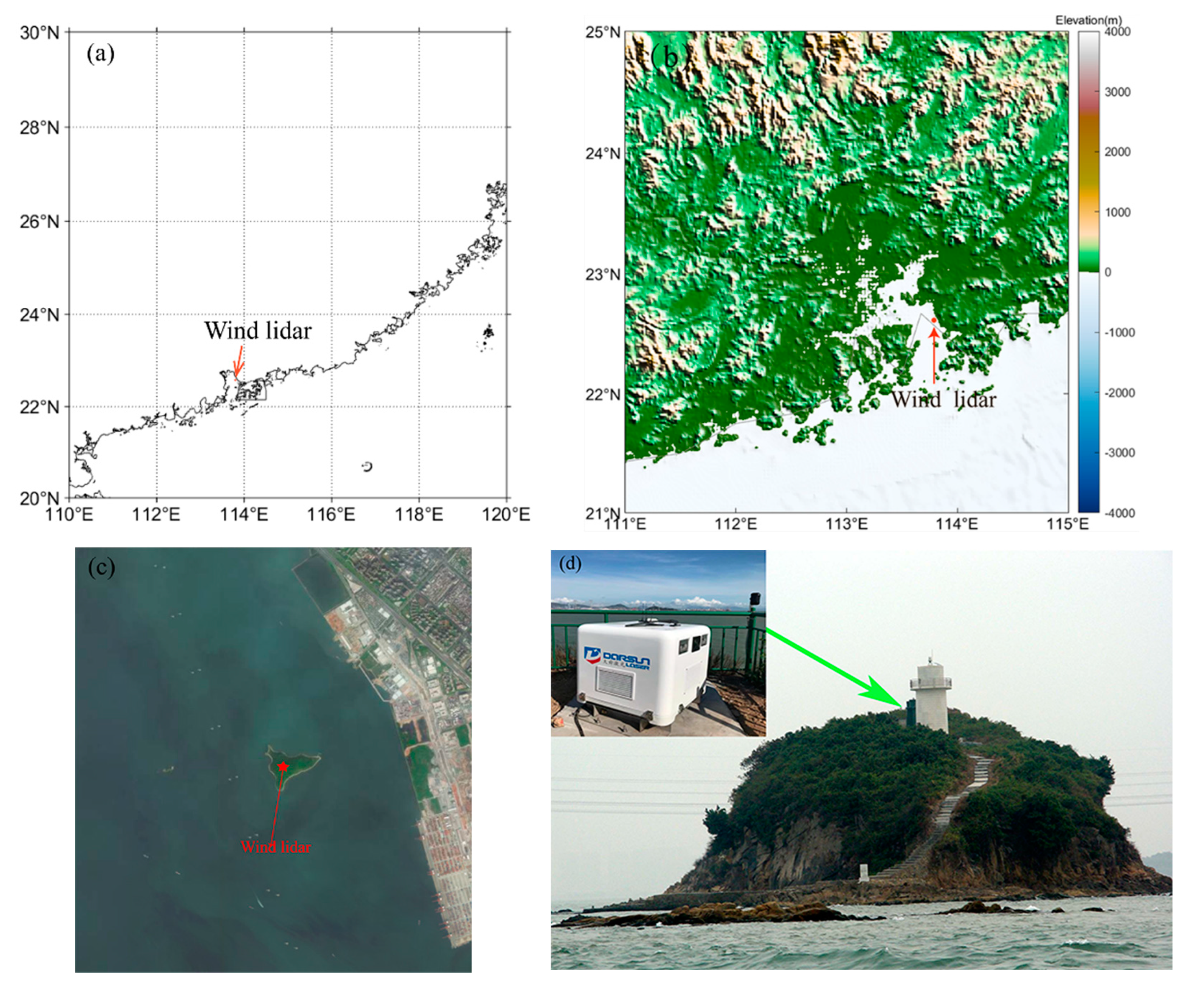
2. Data and Methods
3. Results and Discussion
3.1. General Characteristics
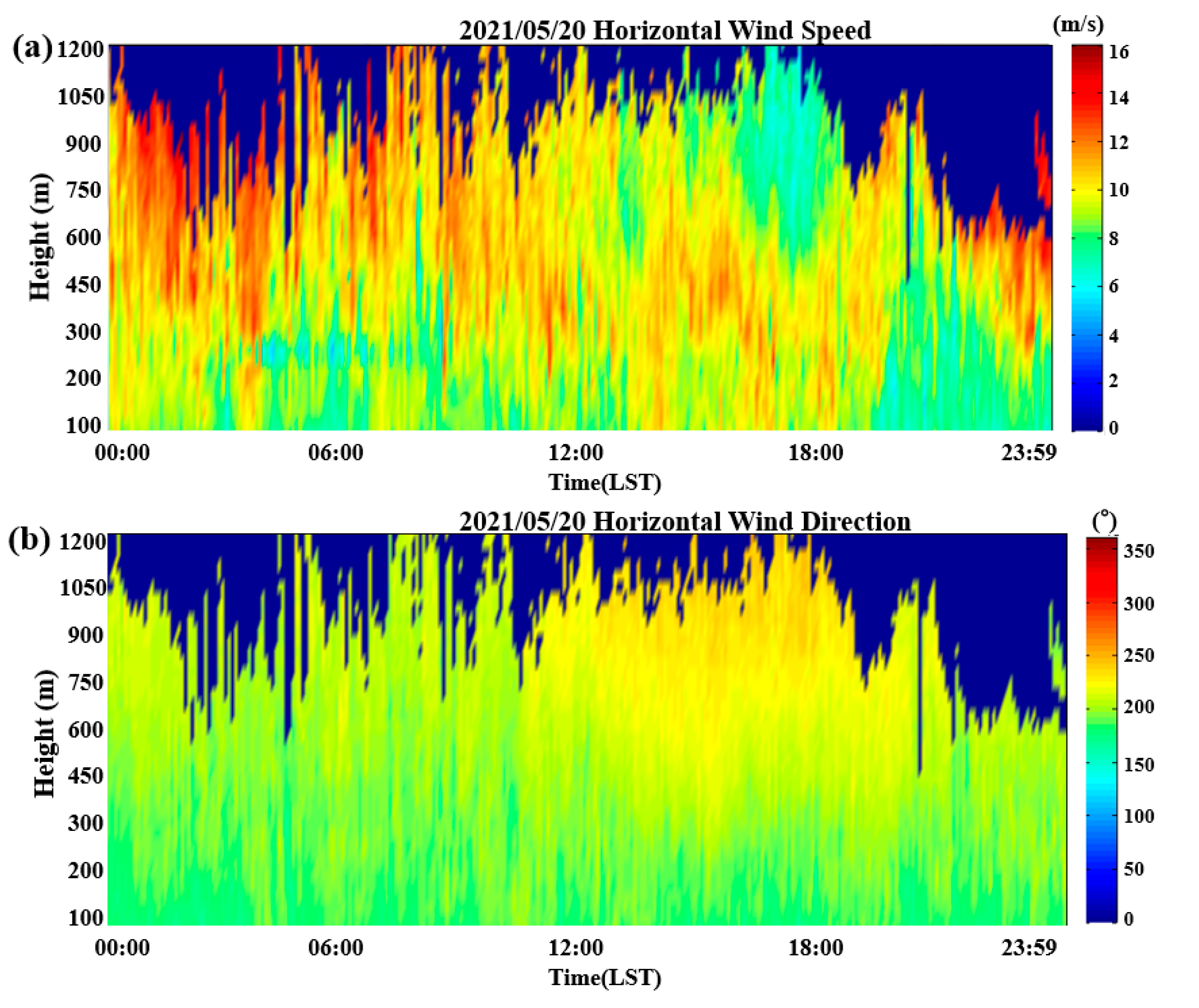
3.1.1. Occurrence Frequency and Vertical Structure
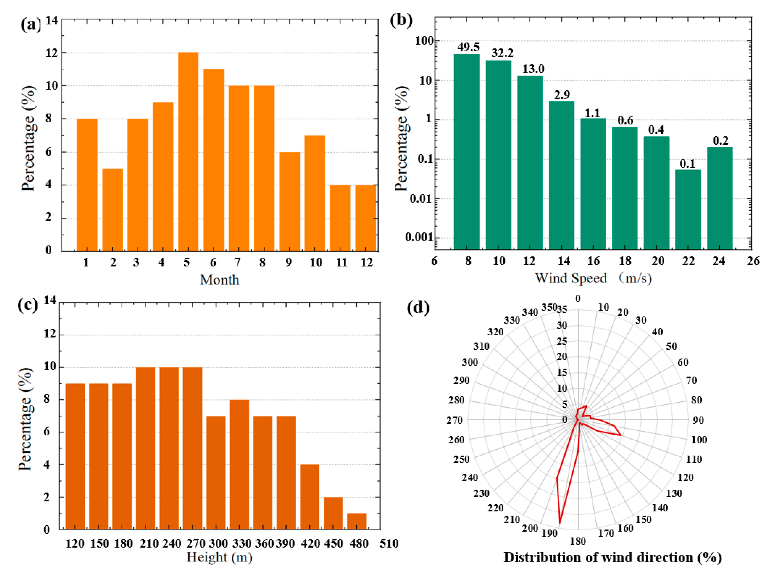
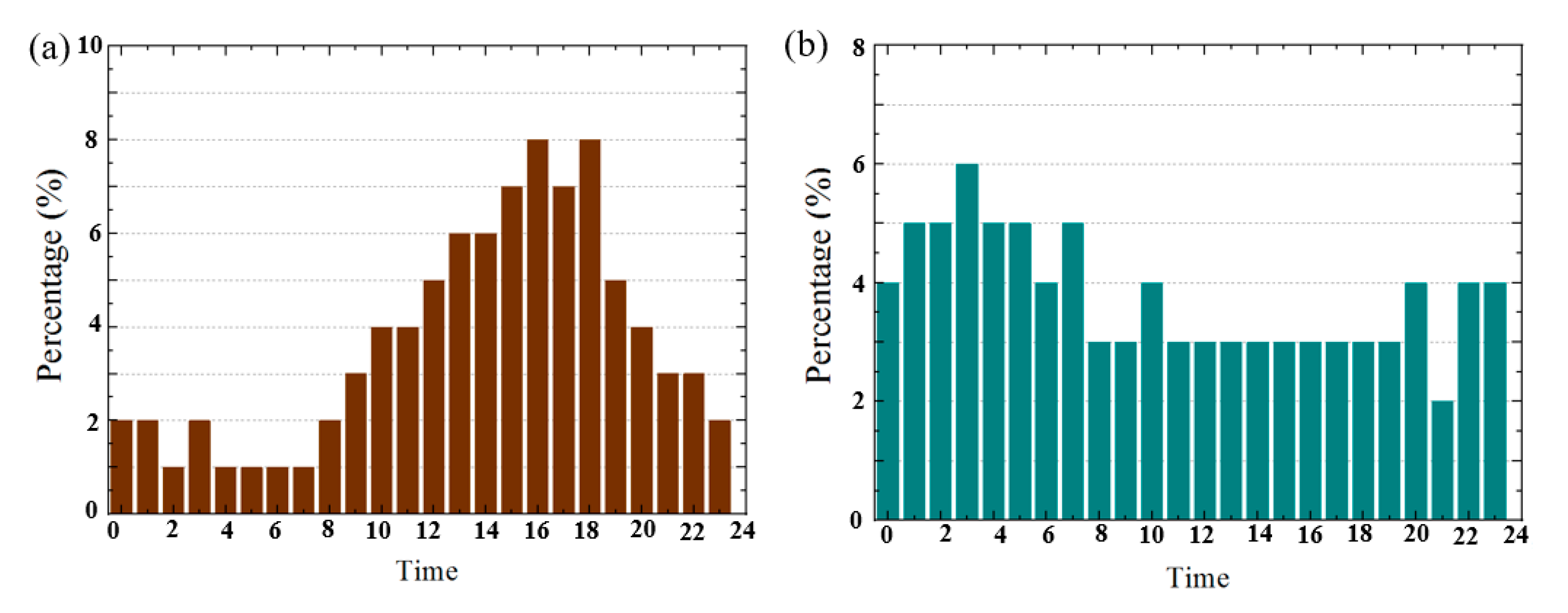
3.1.2. Seasonal and Diurnal Variations
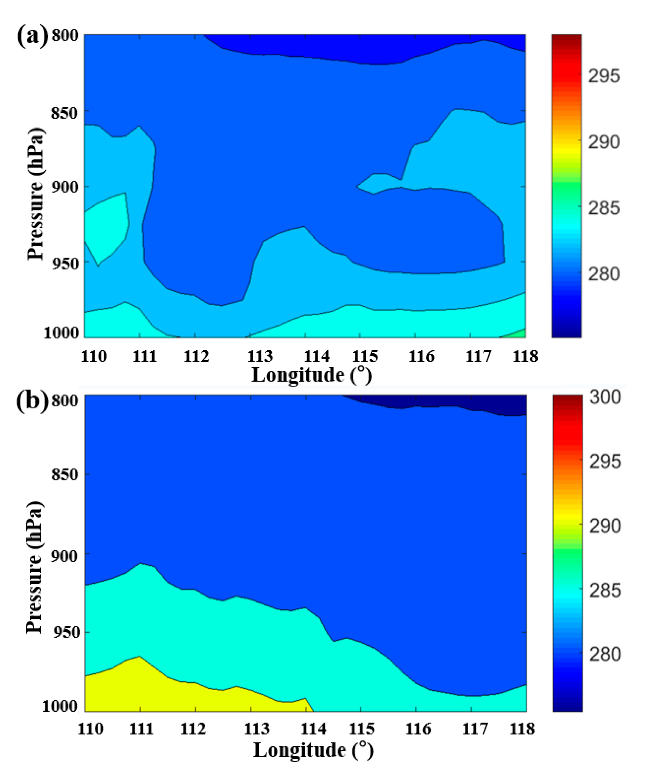
3.2. Formation Mechanisms
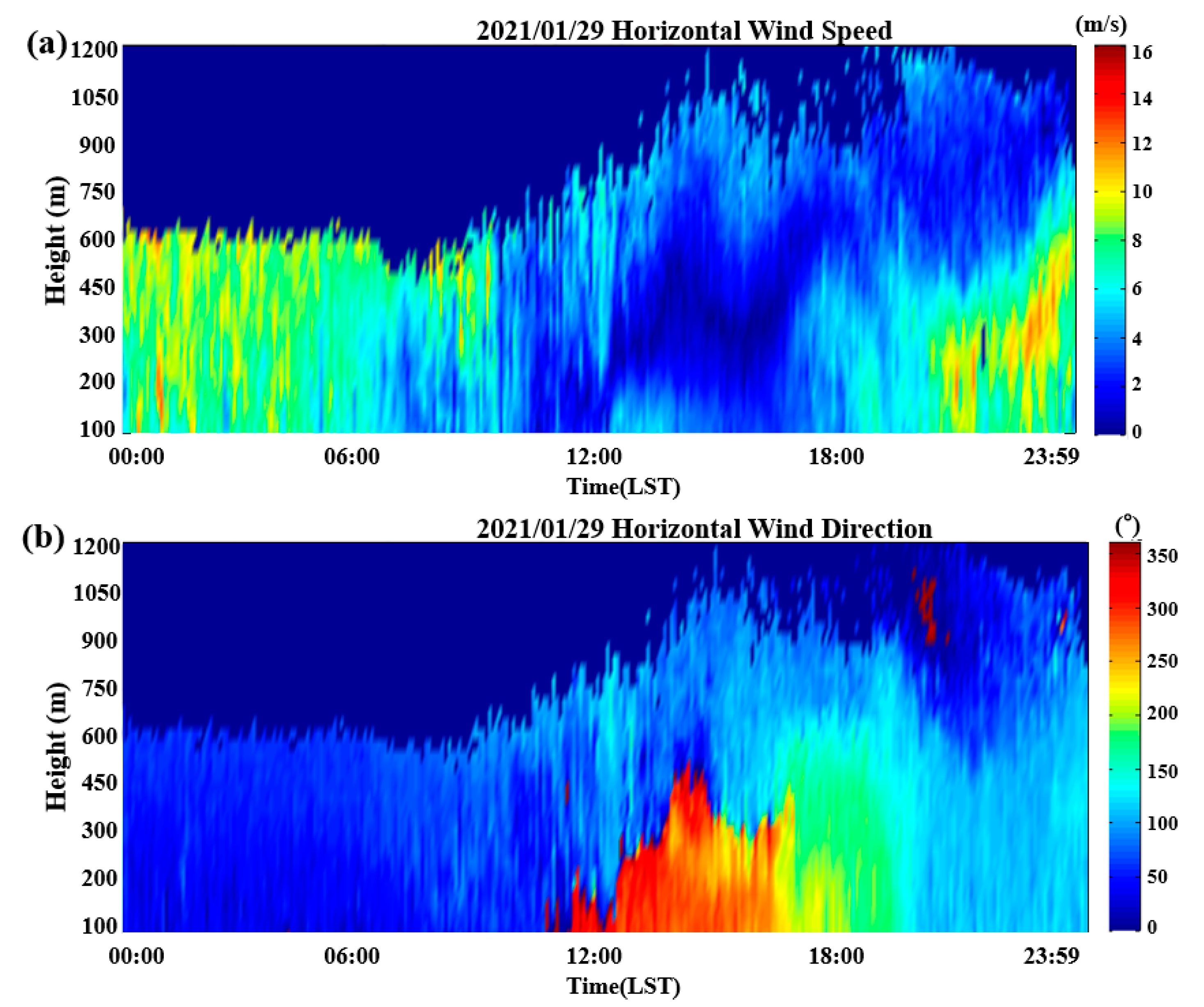
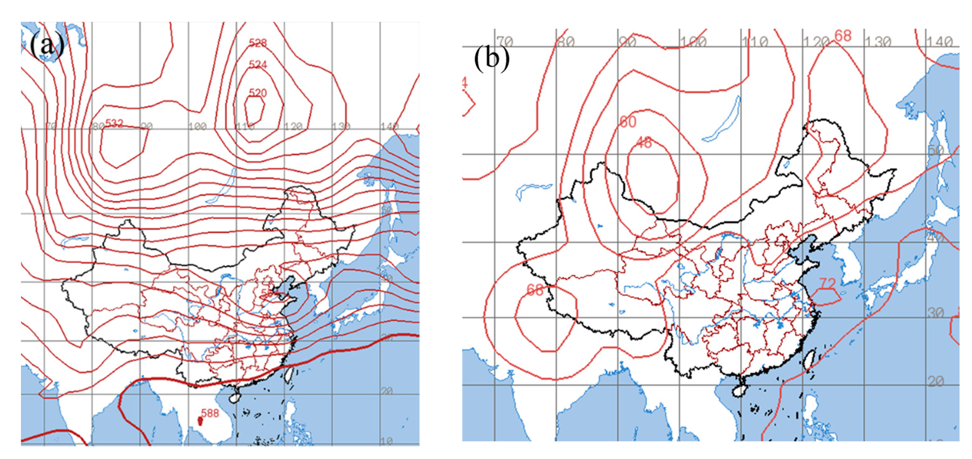
3.2.1. Cold Air
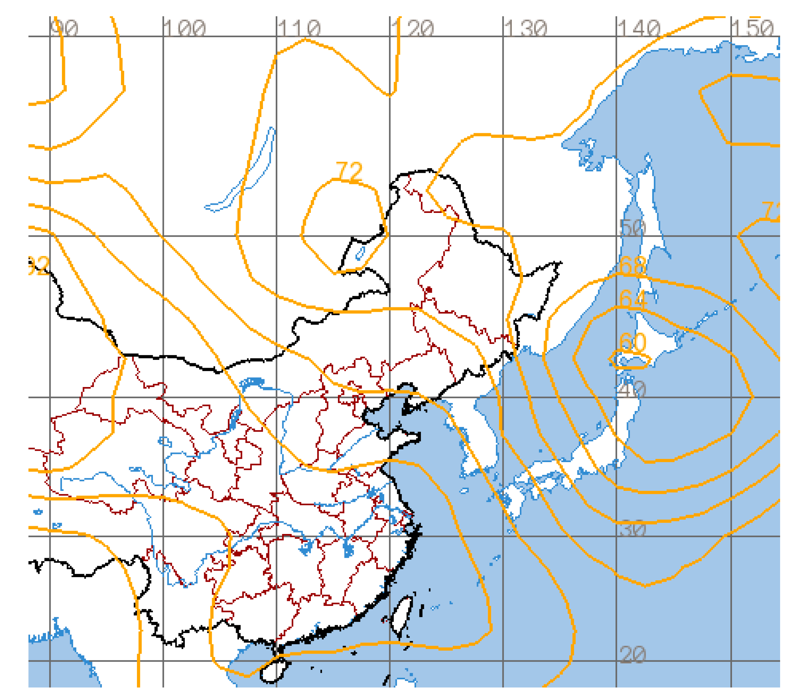
3.2.2. Western Pacific Subtropical High
4. Conclusions
Author Contributions
Funding
Institutional Review Board Statement
Informed Consent Statement
Data Availability Statement
Acknowledgments
Conflicts of Interest
References
- Zheng, C.W.; Li, C.Y.; Pan, J.; Liu, M.Y.; Xia, L.L. An overview of global ocean wind energy resource evaluations. Renew. Sustain. Energy Rev. 2016, 53, 1240–1251. [Google Scholar] [CrossRef]
- Zhou, A.; He, M.; Zhu, R.; Cheng, X. Numerical Simulation of the Development Potential of Wind Energy Resources over China’s Offshore Areas. Resour. Sci. 2010, 32, 1434–1443. [Google Scholar]
- Ranjha, R.; Svensson, G.; Tjernstr, M.M.; Semedo, A. Global distribution and seasonal variability of coastal low-level jets derived from ERA-Interim reanalysis. Tellus Ser. A 2013, 65, 20412. [Google Scholar] [CrossRef]
- Liu, H.; He, M.; Wang, B.; Zhang, Q. Advances in Low-Level Jet Research and Future Prospects. J. Meteorol. Res. 2014, 72, 191–206. [Google Scholar] [CrossRef]
- Du, Y.; Chen, G. Climatology of Low-Level Jets and Their Impact on Rainfall over Southern China during the Early-Summer Rainy Season. J. Clim. 2019, 32, 8813–8833. [Google Scholar] [CrossRef]
- Yang, H.; Lu, C.; Hu, Y.; Chan, P.; Li, L.; Zhang, L. Effects of Horizontal Transport and Vertical Mixing on Nocturnal Ozone Pollution in the Pearl River Delta. Atmosphere 2022, 13, 1318. [Google Scholar] [CrossRef]
- Du, Y.; Chen, Y.; Zhang, Q. Numerical Simulations of the Boundary Layer Jet off the Southeastern Coast of China. Mon. Weather Rev. 2015, 143, 1212–1231. [Google Scholar] [CrossRef]
- Ranjha, R.; Tjernström, M.; Semedo, A.; Svensson, G.; Cardoso, R.M. Structure and variability of the Oman coastal low-level jet. Tellus A Dyn. Meteorol. Oceanogr. 2015, 67, 25285. [Google Scholar] [CrossRef]
- Zhang, F.; Zhang, Q.; Du, Y.; Kong, H. Characteristics of Coastal Low-Level Jets in the Bohai Sea, China, during the Early Warm Season. J. Geophys. Res. Atmos. 2018, 123, 13763–13774. [Google Scholar] [CrossRef]
- Winant, C.D.; Dorman, C.E.; Friehe, C.A.; Beardsley, R.C. The Marine Layer off Northern California: An Example of Supercritical Channel Flow. J. Atmos. Sci. 1988, 45, 3588–3605. [Google Scholar] [CrossRef]
- Kong, H.; Zhang, Q.; Du, Y.; Zhang, F. Characteristics of Coastal Low-Level Jets over Beibu Gulf, China, During the Early Warm Season. J. Geophys. Res. Atmos. 2020, 125, e2019JD031918. [Google Scholar] [CrossRef]
- Li, D.; von Storch, H.; Yin, B.; Xu, Z.; Qi, J.; Wei, W.; Guo, D. Low-Level Jets Over the Bohai Sea and Yellow Sea: Climatology, Variability, and the Relationship with Regional Atmospheric Circulations. J. Geophys. Res. Atmos. 2018, 123, 5240–5260. [Google Scholar] [CrossRef]
- Wei, W.; Zhang, H.S.; Ye, X.X. Comparison of low-level jets along the north coast of China in summer. J. Geophys. Res. Atmos. 2015, 119, 9692–9706. [Google Scholar] [CrossRef]
- Blackadar, A.K. Boundary layer wind maxima and their significance for the growth of nocturnal inversions. Bull Amer. Meteor. Soc. 1957, 5, 283–290. [Google Scholar] [CrossRef]
- Holton, J.R. The diurnal boundary layer wind oscillation above sloping terrain. Tellus 2010, 19, 199–205. [Google Scholar] [CrossRef]
- Jiang, X.; Lau, N.; Held, I.M.; PLoShay, J.J. Mechanisms of the Great Plains Low-Level Jet as Simulated in an AGCM. J. Atmos. Sci. 2007, 64, 532–547. [Google Scholar] [CrossRef]
- Parish, T.R. Forcing of the Summertime Low-Level Jet along the California Coast. J. Appl. Meteorol. 2000, 39, 2421–2433. [Google Scholar] [CrossRef]
- Petenko, I.; Casasanta, G.; Bucci, S.; Kallistratova, M.; Argentini, S. Turbulence, Low-Level Jets, and Waves in the Tyrrhenian Coastal Zone as Shown by Sodar. Atmosphere 2019, 11, 28. [Google Scholar] [CrossRef]
- Yeh, H.C.; Chen, Y.L. Numerical Simulations of the Barrier Jet over Northwestern Taiwan during the Mei-Yu Season. Mon. Weather Rev. 2003, 131, 1396–1407. [Google Scholar] [CrossRef]
- Chen, Y.; Li, J. Characteristics of Surface Airflow and Pressure Patterns over the Island of Taiwan during TAMEX. Mon. Weather Rev. 1995, 123, 695–716. [Google Scholar] [CrossRef]
- Ridgway, K.R.; Dunn, J.R. Mesoscale structure of the mean East Australian Current System and its relationship with topography. Prog. Ocean. 2003, 56, 189–222. [Google Scholar] [CrossRef]
- Lin, P.; Chen, Y.; Chen, C.; Liu, C.; Chen, C. Numerical experiments investigating the orographic effects on a heavy rainfall event over the northwestern coast of Taiwan during TAMEX IOP 13. Meteorol. Atmos. Phys. 2011, 114, 35. [Google Scholar] [CrossRef]
- Li, L.; Chan, P.W.; Deng, T.; Yang, H.; Luo, H.; Xia, D.; He, Y. Review of advances in urban climate study in the Guangdong-Hong Kong-Macau Greater Bay Area, China. Atmos. Res. 2021, 261, 105759. [Google Scholar] [CrossRef]
- Hui, E.C.M.; Li, X.; Chen, T.; Lang, W. Deciphering the spatial structure of China’s megacity region: A new bay area—The Guangdong-Hong Kong-Macao Greater Bay Area in the making. Cities 2020, 105, 102168. [Google Scholar] [CrossRef]
- Miao, Y.; Guo, J.; Liu, S.; Wei, W.; Zhang, G.; Lin, Y.; Zhai, P. The Climatology of Low-Level Jet in Beijing and Guangzhou, China. J. Geophys. Res. Atmos. 2018, 123, 2816–2830. [Google Scholar] [CrossRef]
- Shu, Z.R.; Li, Q.S.; He, Y.C.; Chan, P.W. Investigation of low-level jet characteristics based on wind profiler observations. J. Wind Eng. Ind. Aerod. 2018, 174, 369–381. [Google Scholar] [CrossRef]
- Du, Y.; Chen, G. Heavy Rainfall Associated with Double Low-Level Jets over Southern China. Part I: Ensemble-Based Analysis. Mon. Weather Rev. 2018, 146, 3827–3844. [Google Scholar] [CrossRef]
- Zhang, M.; Meng, Z. Warm-Sector Heavy Rainfall in Southern China and Its WRF Simulation Evaluation: A Low-Level-Jet Perspective. Mon. Weather Rev. 2019, 147, 4461–4480. [Google Scholar] [CrossRef]
- Bonner, W.D. Climatology of the low level jet. Mon. Weather Rev. 1968, 96, 833–850. [Google Scholar] [CrossRef]
- Atkins, N.T.; Wakimoto, R.M.; Weckwerth, T.M. Observations of the Sea-Breeze Front during CaPE. Part II: Dual-Doppler and Aircraft Analysis. Mon. Wea. Rev. 1995, 123, 944–969. [Google Scholar] [CrossRef]
- Paegle, J.; Rasch, G.E. Three-Dimensional Characteristics of Diurnally Varying Boundary-Layer Flows. Mon. Weather Rev. 1973, 101, 746–756. [Google Scholar] [CrossRef]
- Carrera, M.L.; Gyakum, J.R.; Lin, C.A. Observational Study of Wind Channeling within the St. Lawrence River Valley. J. Appl. Meteorol. Clim. 2009, 48, 2341–2361. [Google Scholar] [CrossRef]


| Metrics | Technical Performance Requirements |
|---|---|
| Blind zone | ≤30 m |
| Distance resolution | 15 m |
| Temporal resolution of wind profile | 1 min |
| Errors of wind speed measurement (standard deviation) | ≤0.3 m s−1 |
| Errors of wind direction measurement (root mean squared error) | ≤3° |
| Range of radial wind speed measurement | ±37.5 m s−1 |
| Range of vertical wind speed measurement | 0–60 m s−1 |
| Range of wind direction measurement | 0°–360° |
| Resolution of radial wind speed | ≤0.1 m s−1 |
| Wind speed resolution | ≤0.1 m s−1 |
| Wind direction resolution | ≤0.1° |
Disclaimer/Publisher’s Note: The statements, opinions and data contained in all publications are solely those of the individual author(s) and contributor(s) and not of MDPI and/or the editor(s). MDPI and/or the editor(s) disclaim responsibility for any injury to people or property resulting from any ideas, methods, instructions or products referred to in the content. |
© 2023 by the authors. Licensee MDPI, Basel, Switzerland. This article is an open access article distributed under the terms and conditions of the Creative Commons Attribution (CC BY) license (https://creativecommons.org/licenses/by/4.0/).
Share and Cite
Qiu, Z.; Xian, J.; Yang, Y.; Lu, C.; Yang, H.; Hu, Y.; Sun, J.; Zhang, C. Characteristics of Coastal Low-Level Jets in the Boundary Layer of the Pearl River Estuary. J. Mar. Sci. Eng. 2023, 11, 1128. https://doi.org/10.3390/jmse11061128
Qiu Z, Xian J, Yang Y, Lu C, Yang H, Hu Y, Sun J, Zhang C. Characteristics of Coastal Low-Level Jets in the Boundary Layer of the Pearl River Estuary. Journal of Marine Science and Engineering. 2023; 11(6):1128. https://doi.org/10.3390/jmse11061128
Chicago/Turabian StyleQiu, Zongxu, Jinhong Xian, Yuexin Yang, Chao Lu, Honglong Yang, Yuanyuan Hu, Jiaqi Sun, and Chunsheng Zhang. 2023. "Characteristics of Coastal Low-Level Jets in the Boundary Layer of the Pearl River Estuary" Journal of Marine Science and Engineering 11, no. 6: 1128. https://doi.org/10.3390/jmse11061128