
A Methodological Proposal for the Management of Submerged Cultural Heritage: Study Cases from Cartagena de Indias, Colombia
 , , ,
, , ,  ,
, 
Abstract
:1. Introduction
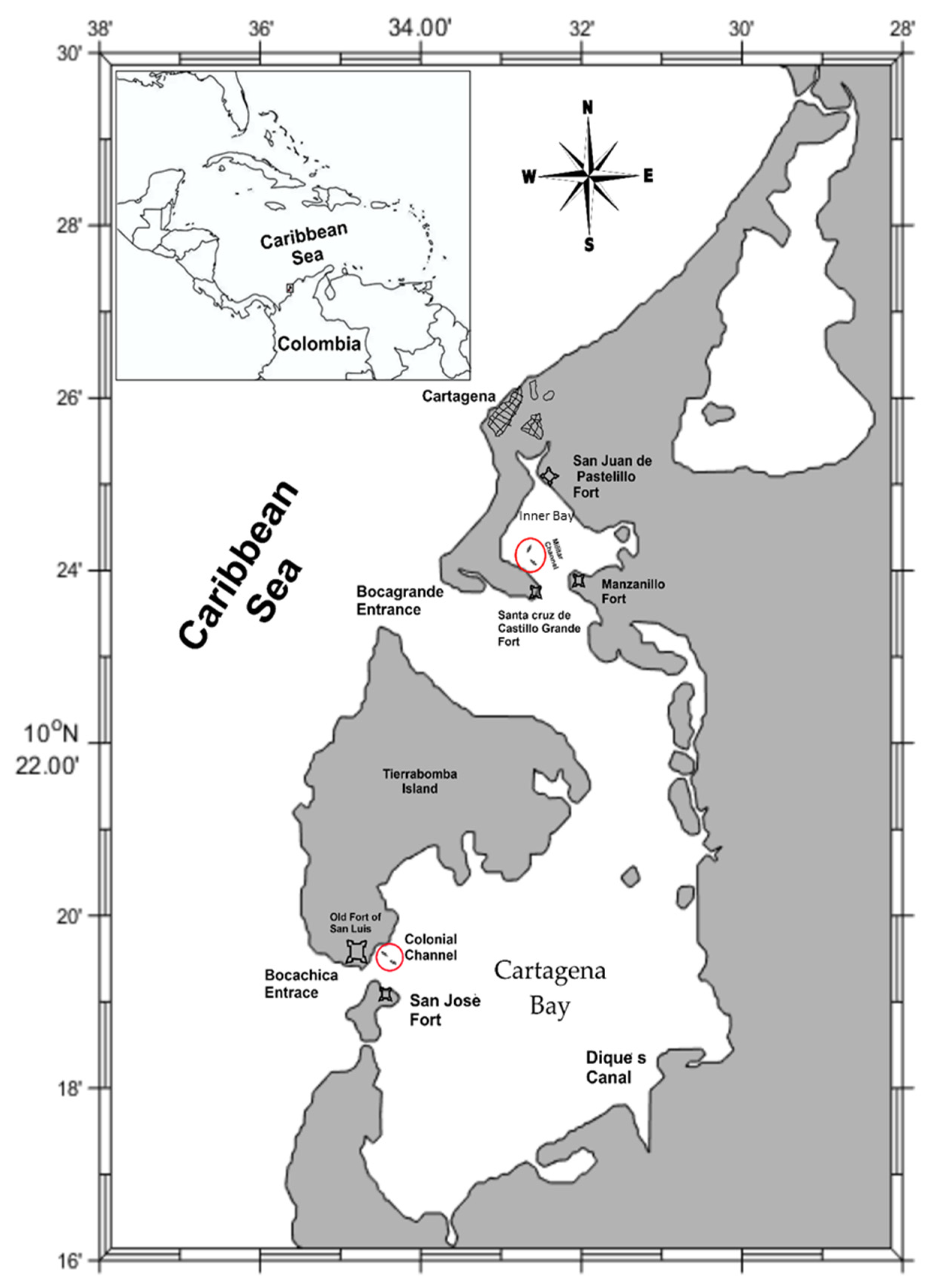
2. Study Area
3. Methodology
3.1. Historical Criterion
3.2. Geographic Criterion
3.3. Shipweck Condition Criterion
- -
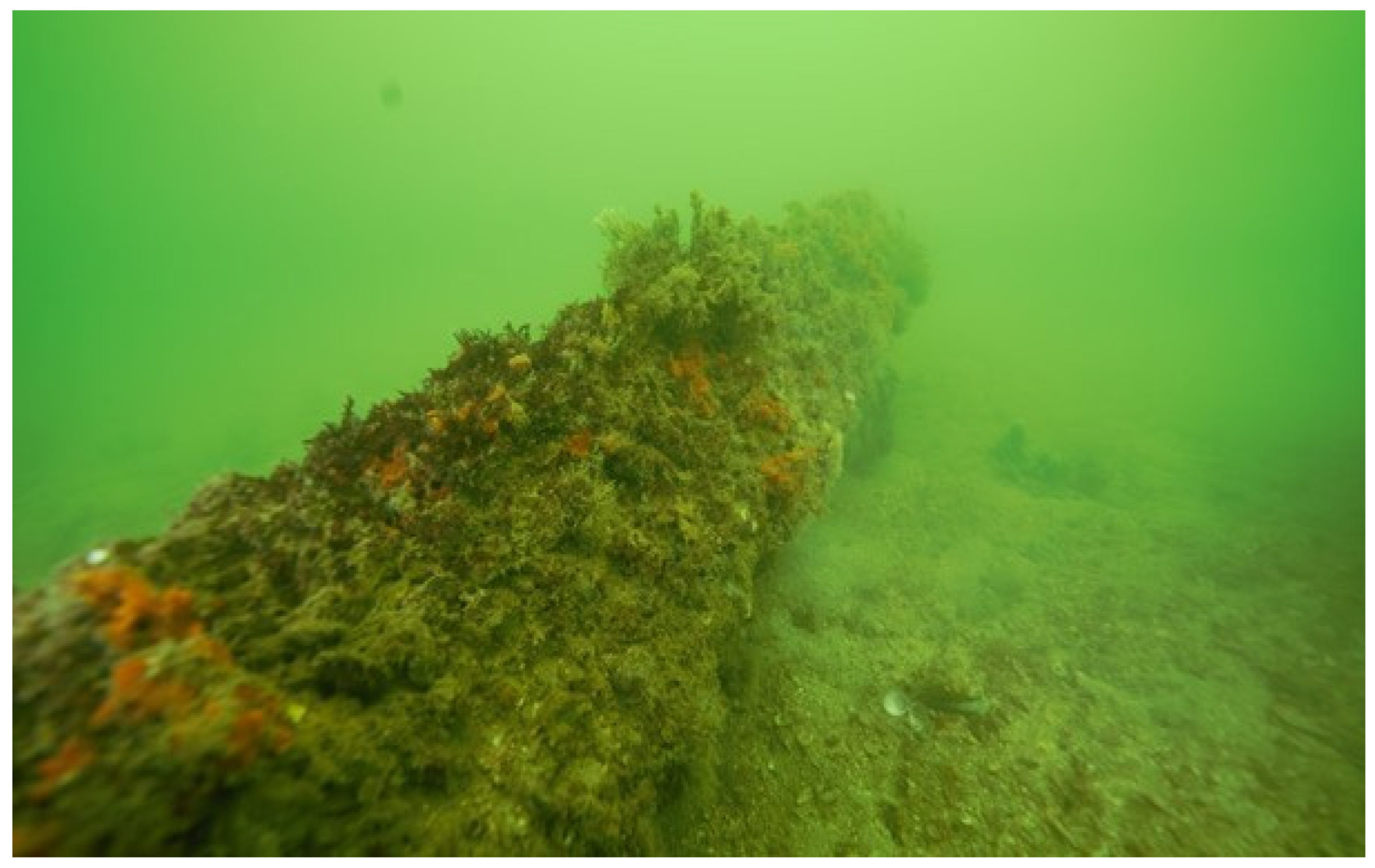
- Non-intrusive inspection with autonomous diving. The purpose of this inspection was to recognise the elements associated with the shipwrecks and their state of conservation, both in Bocachica and in the Inner Bay. For the purposes of this work, diving was carried out following the guidelines of the Nautical Archaeological Society (NAS).
- -
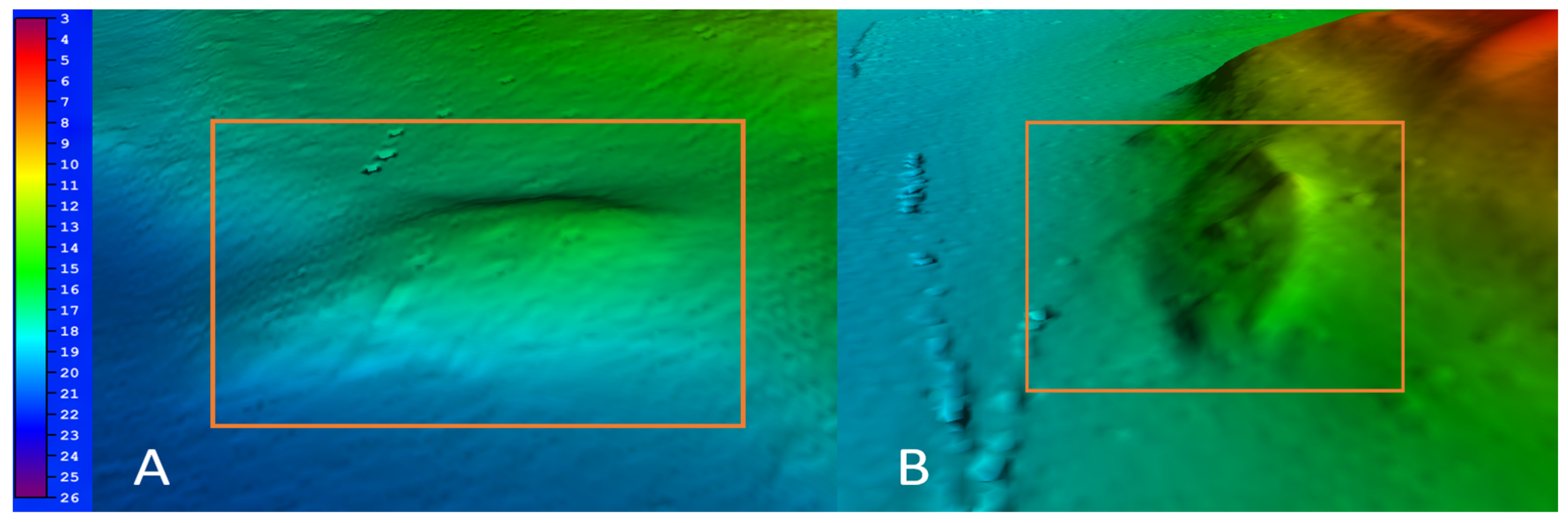
- Hydrographic and geophysical characterisation. A MultiBeam EchoSounder (MBES Konsberg 2040C) and Side Scan Sonar (SSS Pulsar 200) were used to map the seabed. Methodological details are given by Quintana-Saavedra et al. [28].
3.4. Oceanographic Criterion
3.5. Socioeconomic Criterion
4. Results
4.1. Historical Criterion
4.2. Geographic Criterion
4.3. Shipwreck Condition Criterion
4.4. Oceanographic Criterion
4.5. Socioeconomic Criterion
5. Discussion
5.1. Analysis and Integration of the Scores Obtained in the Cartagena Bay Sites
5.2. Other Transversal Management Requirements for the Cartagena Bay Sites
5.2.1. Legal Aspects and Involved Organizations
5.2.2. Handling and Practical Management Actions
- Delimitation of the area of interest: The cultural and maritime authorities must establish a specific area for the management of wrecks to regulate, control and define the levels of intervention with the purpose of guaranteeing their long-term preservation, to advance research actions, as well as the dissemination and conservation of the submerged heritage. Based on the case study results, the creation of a minimum area of protection and conservation is suggested with a radius no greater than 500 m with each shipwreck as its center. The area should include seawater and seabed. Care must be taken not to affect the use or transit of merchant ships on the surface through the established navigation channels.
- Monitoring coordinating entity: To carry out conservation activities, it is important to have a base work site from where semi-annual oceanographic and hydrographic campaigns are launched. If relocation of material is required, a contiguous maritime area must be provided whose conditions are similar to the original one.
- Disclosure: The disclosure of sites associated with the UCH to the general public involves the publication of scientific articles and guided tours, among other activities [21,70]. Worldwide, there are sites that have been opened to the public, such as the L’Océan shipwreck in Portugal [71] and Formentera and Es Cap 1 in Spain [72]. Therefore, it is suggested, as a management action, to make a section of the Conquistador ship available to the community for guided and controlled diving visits. This action will strengthen the recognition of submerged cultural assets by the public, also enhancing their relationship with scientific research centres.
- Staff competencies: Considering the specificity of the subject, the participating staff in management activities must be interdisciplinary, be supervised by suitable professionals in archaeological matters [73] and have a safety regime at work in terms of diving. Additionally, the experience will be required in metric plan survey techniques, analysis of hydrographic data from remote sensors and the sampling and handling of oceanographic equipment, among others.
6. Conclusions
Author Contributions
Funding
Institutional Review Board Statement
Data Availability Statement
Acknowledgments
Conflicts of Interest
References
- Unesco. La Convención de la Unesco sobre la Protección del Patrimonio Cultural Subacuático. Conv. Sobre Protección Patrim. Cult. Subacuático. 2001. 26p. Available online: https://unesdoc.unesco.org/ark:/48223/pf0000126065_spa498 (accessed on 23 February 2023).
- Manders, M.R. Guidelines for Protection of Submerged Wooden Cultural Heritage 2011. reckProtect. European Commission’s Seventh Framework Program. Available online: http://wreckprotect.org/typo3temp/tx_ncstaticfilecache/wreckprotect.org//index.php/ (accessed on 28 February 2023).
- Bethencourt, M.; Fernández-Montblanc, T.; Izquierdo, A.; González-Duarte, M.; Muñoz-Mas, C. Study of the influence of physical, chemical and biological conditions that influence the deterioration and protection of Underwater Cultural Heritage. Sci. Total Environ. 2018, 613–614, 98–114. [Google Scholar] [CrossRef] [PubMed]
- O’Shea, J. The archaeology of scattered wreck-sites: Formation processes and shallow water archaeology in western Lake Huron. Int. J. Naut. Archaeol. 2002, 31, 211–227. [Google Scholar] [CrossRef] [Green Version]
- Ward, I.; Larcombe, P.; Veth, P. A new process-based model for wreck site formation. J. Archaeol. Sci. 1999, 26, 561–570. [Google Scholar] [CrossRef]
- Fernández-Montblanc, T.; Quinn, R.; Izquierdo, A.; Bethencourt, M. Evolution of a Shallow Water Wave-Dominated Shipwreck Site: Fougueux (1805), Gulf of Cadiz. Geoarchaeology 2016, 31, 487–505. [Google Scholar] [CrossRef]
- Grenier, R.; Nutley, D.; Cochran, I. Heritage at Risk: Special Edition—Underwater Cultural Heritage at Risk: Managing Natural and Human Impacts; ICOMOS: Paris, France, 2006. [Google Scholar]
- Gusick, A.E.; Dodds, T.; Jaffke, D.; Meniketti, M.; Ball, D. Defining Maritime Cultural Landscapes in California. Calif. Archaeol. 2019, 11, 139–164. [Google Scholar] [CrossRef]
- UNESCO. Underwater Cultural Heritage in Latin America and the Caribbean. 2015. Available online: https://unesdoc.unesco.org/ark:/48223/pf0000232319_eng (accessed on 3 December 2022).
- Bickler, S.; Clough, R.; Macready, S. The impact of climate change on the archaeology of New Zealand’s coastline: A case study from the Whangarei District. Sci. Conserv. 2013, 1–54. [Google Scholar]
- Agapiou, A.; Lysandrou, V. Remote sensing archaeology: Tracking and mapping evolution in European scientific literature from 1999 to 2015. J. Archaeol. Sci. Rep. 2015, 4, 192–200. [Google Scholar] [CrossRef]
- Jigena-Antelo, B.; Berrocoso, M.; Torrecillas, C.; Vidal, J.; Barbero, I.; Fernandez-Ros, A. Determination of an experimental geoid at Deception Island, South Shetland Islands, Antarctica. Antarct. Sci. 2016, 28, 277–292. [Google Scholar] [CrossRef]
- Osorio-Granada, A.M.; Jigena-Antelo, B.; Vidal Pérez, J.M.; Hernández-Pardo, O.; León-Rincón, H.; Muñoz-Pérez, J.J. Potential fields modeling for the Cayos Basin (Western Caribbean Plate): Implications in basin crustal structure. Mar. Geol. 2022, 449, 106819. [Google Scholar] [CrossRef]
- Mattei, G.; Rizzo, A.; Anfuso, G.; Aucelli PP, C.; Gracia, F.J. A tool for evaluating the archaeological heritage vulnerability to coastal processes: The case study of Naples Gulf (southern Italy). Ocean Coast. Manag. 2019, v179. [Google Scholar] [CrossRef]
- MacCready, P.; Geyer, W.R. Advances in estuarine physics. Ann. Rev. Mar. Sci. 2010, 2, 35–58. [Google Scholar] [CrossRef] [PubMed] [Green Version]
- González-Duarte, M.M.; Fernández-Montblanc, T.; Bethencourt, M.; Izquierdo, A. Effects of substrata and environmental conditions on ecological succession on historic shipwrecks. Estuar. Coast. Shelf Sci. 2018, 200, 301–310. [Google Scholar] [CrossRef]
- Church, R.; Warren, D.; Cullimore, R.; Johnston, L.; Schroeder, W.; Patterson, W.; Shirley, T.; Kilgour, M.; Morris, N.; Moore, J. Archaeological and Biological Analysis of World War II Shipwrecks in the Gulf of Mexico: Artificial Reef Effect in Deep Water. OCS Study MMS 2007, 15, 387. Available online: https://www.boem.gov/ESPIS/4/4239.pdf (accessed on 31 November 2022).
- Balletti, C.; Beltrame, C.; Costa, E.; Guerra, F.; Vernier, P. 3D reconstruction of marble shipwreck cargoes based on underwater multi-image photogrammetry. Digit. Appl. Archaeol. Cult. Herit. 2016, 3, 1–8. [Google Scholar] [CrossRef]
- Harkin, D.V.; Davies, M.; Hyslop, E.; Fluck, H.; Wiggins, M.; Merritt, O.; Barker, L.; Deery, M.; McNeary, R.; Westley, K. Impacts of climate change on cultural heritage. Mar. Clim. Chang. Impacts Partnersh. 2020, 16, 24–39. [Google Scholar] [CrossRef]
- Daire, M.Y.; Lopez-Romero, E.; Proust, J.N.; Regnauld, H.; Pian, S.; Shi, B. Coastal Changes and Cultural Heritage (1): Assessment of the Vulnerability of the Coastal Heritage in Western France. J. Isl. Coast. Archaeol. 2012, 7, 168–182. [Google Scholar] [CrossRef] [Green Version]
- Maarleveld, T.; Guérin, U.; Egger, B. Manual Para Actividades Dirigidas Al Patrimonio Cultural Subacuático. 2013. Available online: https://unesdoc.unesco.org/ark:/48223/pf0000220716 (accessed on 28 February 2023).
- Molares, R.; Mestres, M. La influencia de la descarga del Canal del Dique en los niveles del mar de la Bahía de Cartagena-Colombia. Bol. Cient. CIOH 2012, 45, 13–28. [Google Scholar] [CrossRef] [Green Version]
- Borrero Londoño, R. Thesis Procesos de Formación de Sitios Arqueológicos Sumergidos en la Bahía de Cartagena de Indias Estudio Experimental Sobre Degradación de Materiales Orgánicos Empleados en la Construcción Naval y/o Contenidos en los Fletes Coloniales; Bogotá-University of the Andes: Bogotá, Colombia, 2011. [Google Scholar]
- Del Cairo Hurtado, C. Mentiras verdaderas o la topología de la guerra. Aproximación arqueológica a la cartografía colonial de Bocachica, Cartagena de Indias. Apunt. Rev. Estud. Sobre Patrim. Cult. 2014, 26, 186–203. [Google Scholar] [CrossRef] [Green Version]
- Andrade, C.A.; Guzmán-Martinez, R.; Quintana-Saavedra, D.M. El avance de la línea de costa de las penínsulas de Bocagrande y Castillo grande debido a la construcción de la Escollera en 1758 en Cartagena de Indias. Rev. Acad. Colomb. Cienc. 2022, 46, 758–768. [Google Scholar] [CrossRef]
- Manders, M.R. UNIT 9: In Situ Preservation. In Training Manual for the UNESCO Foundation Course on the Protection and Management of Underwater Cultural Heritage in Asia and the Pacific; UNESCO: London, UK, 2022; pp. 1–33. [Google Scholar]
- Frigerio, A. The Underwater Cultural Heritage: A Comparative Analysis of International Perspectives, Laws and Methods of Management; IMT Institute for Advanced Studies: Lucca, Italy, 2013. [Google Scholar]
- Quintana-Saavedra, D.M.; Andrade-Amaya, C.A.; Guzmán-Martínez, R.A.; Torres-Parra, R.; Prada-Rueda, P. Characterization of four shipwrecks from 1741 in Cartagena Bay. Int. Hydrogr. Rev. 2022, 27, 55–74. Available online: https://ihr.iho.int/issue-archive/ (accessed on 21 August 2022). [CrossRef]
- De Lezo, B. Carta de D. Blas de Lezo al Marqués de Villarias, con un Diario de lo Acaecido en Cartagena de Indias Durante el Sitio, Desde el 13 de Marzo de 1741 hasta el 20 de Mayo Siguiente. 1741. Archivo Histórico Nacional, ESTADO,2335, Exp.2 España. Available online: http://pares.mcu.es/ParesBusquedas20/catalogo/show/12690215?nm (accessed on 25 November 2022).
- Beatson, R. Naval and Military Memoirs of Great Britain, from 1727 to 1783. 1804. Available online: https://books.google.com.co/books?id=eNEHAAAAIAAJ&printsec=frontcover&hl=es&source=gbs_ge_summary_r&cad=0#v=onepage&q&f=false (accessed on 14 June 2020).
- IOC-UNESCO. a. Marine Spatial Planning. 2022. Available online: https://www.mspglobal2030.org/es/msp-roadmap/la-pem-en-el-mundo/ (accessed on 23 February 2023).
- Ødegård, Ø.; Sørensen, A.J.; Hansen, R.E.; Ludvigsen, M. A new method for underwater archaeological surveying using sensors and unmanned platforms. IFAC-PapersOnLine 2016, 49, 486–493. [Google Scholar] [CrossRef]
- Westley, K.; Plets, R.; Quinn, R.; McGonigle, C.; Sacchetti, F.; Dale, M.; McNeary, R.; Clements, A. Optimising protocols for high-definition imaging of historic shipwrecks using multibeam echosounder. Archaeol. Anthropol. Sci. 2019, 11, 3629–3645. [Google Scholar] [CrossRef]
- Rosato, V.; Traversa, L. Bioalteración, Protección y Conservacion de Maderas; Publicaciones Científicas y Tecnológicas: Buenos Aires, Argentina, 2017. [Google Scholar]
- Grosso, M.; Elkin, D.; Murray, C.; Castro, M.Á. Evidencia arqueológica de naufragios en zonas costeras: El caso del Parque Nacional Monte León (provincia de Santa Cruz). Magallania 2015, 43, 93–118. [Google Scholar] [CrossRef] [Green Version]
- Gibbs, M. Cultural site formation processes in maritime archaeology: Disaster response, salvage and Muckelroy 30 years on. Int. J. Naut. Archaeol. 2006, 35, 4–19. [Google Scholar] [CrossRef]
- Andreu, R.; Ex, M. Ex situ o in situ: Dilemas de la conservación y protección del patrimonio cultural sumergido. Bol. Cient. CIOH 2021, 40, 121–128. Available online: https://ojs.dimar.mil.co/index.php/CIOH/article/view/598/498 (accessed on 7 September 2022).
- Delgadillo-Garzón, Ó.; Zapata-Ramírez, P. Contexto natural del patrimonio cultural subacuático en la Bahía de Cartagena: Perspectivas de estudios interdisciplinarios y potencial de utilización. Mem. Rev. Digit. Hist. Arqueol. Caribe 2007, 7, 1–6. [Google Scholar]
- Wheeler, A.J. Environmental controls on shipwreck preservation: The Irish context. J. Archaeol. Sci. 2002, 29, 1149–1159. [Google Scholar] [CrossRef]
- IOC-UNESCO. Joint Roadmap to accelerate Maritime/Marine Spatial Planning processes worldwide (MSP). In Proceedings of the 2nd International Conference on Marine/Maritime Spatial Planning, Paris, France, 15–17 March 2017; p. 5. [Google Scholar]
- IOC-UNESCO. b. Marine Spatial Planning. 2022. Available online: https://www.mspglobal2030.org/es/msp-roadmap/la-pem-en-el-mundo/americas/colombia/ (accessed on 23 February 2023).
- Franco, F.A.; Molina Jiménez, M.P.; Pusquin Ospina, L.T.; Escobar Olaya, G.A.; Castro Mercado, I. Conflictos de uso en el proceso de ordenamiento marino costero: Visión de autoridad marítima. Departamento De Bolívar—Colombia. Bol. Cient. CIOH 2019, 38, 27–40. [Google Scholar] [CrossRef]
- DIMAR. Dirección General Marítima. Estadística de Transporte Marítimo Internacional. Series Históricas. 2021. Available online: https://www.dimar.mil.co/operaciones-estadisticas/estadisticas-de-transporte-maritimo-internacional/series-historicas-estadisticas-de-transporte-maritimo-internacional (accessed on 17 June 2022).
- Bass, G.F. Beneath the seven seas. In Adventures with the Institute of Nautical Archaeology, George F.; Institute of Nautical Archaeology; Thames & Hudson Inc.: New York, NY, USA, 2005; ISBN 9780500051368. [Google Scholar]
- Voulgaris, A.; Mouratidis, C.; Vossinakis, A. Simulation and Analysis of Natural Seawater Chemical Reactions on the Antikythera Mechanism. J. Coast. Res. 2019, 35, 959. [Google Scholar] [CrossRef]
- Oxley, L.; Keith, M. Introduction: Site formation processes of submerged shipwrecks. In Site Formation Processes of Sub Merged Shipwrecks; Keith, M.E., Ed.; University of Florida: Gainesville, FL, USA, 2016; p. 13. [Google Scholar]
- Björdal, C. Evaluation of microbial degradation of shipwrecks in the Baltic Sea. Int. Biodeterior. Biodegrad. 2012, 70, 126–140. [Google Scholar] [CrossRef]
- Grosso, M. Post-depositional processes studies of wooden artifacts from the 18th century Swift shipwreck site (Patagonia, Argentina). Intersecc. Antropol. 2014, 15, 55–69. [Google Scholar]
- Papageorgiou, M. Underwater cultural heritage facing maritime spatial planning: Legislative and technical issues. Ocean. Coast. Manag. 2018, 165, 195–202. [Google Scholar] [CrossRef]
- Aldana, J. Propuesta Metodológica para la Construcción de una Matriz de Indicadores Arqueológicos e Históricos para la Identificación de Naufragios: El Caso de un Navío Colonial Ubicado en el Canal de Bocachica (Cartagena de Indias). Bacherlor’s Thesis, Universidad Externado de Colombia, Bogotá, Colombia, 2019. [Google Scholar]
- Bellin, J. Baye de Carthagene: Dans l’Amerique meridionale. Paris. 1764. Available online: https://babel.banrepcultural.org/digital/collection/p17054coll13/id/25/ (accessed on 20 May 2022).
- Durell, P. Plan and Prospect of the Harbour Town & Castles of Carthagena/Most Humbly. p. 1. 1741. Available online: http://catalogue.bnf.fr/ark:/12148/cb442267721 (accessed on 7 April 2022).
- Laws, W. A New Plan of the Harbour, City and Forts of Cartagena; with The Progress of the Brettish Fleet in the Several Stations & Attack from the 4th. of March 1741 the 1st. April When Capt. Laws Came Away. Sent over by Mr. Richardson form on Board the Norfolk. Paris. 1741. Available online: https://gallica.bnf.fr/ark:/12148/btv1b53122178n/f1.item.zoom# (accessed on 20 May 2022).
- Laws, W. Most Humbly Inscribed to the Rt. Honble. Sir Charles Wager, First Lord Commissioner of the Admiralty, This Plan of the Harbour, Town and Several Forts of Cartagena/Will. Laws; W. H. Toms, Sculp. S. Harding, London 1741. Available online: http://catalogue.bnf.fr/ark:/12148/cb442163794 (accessed on 20 May 2022).
- Ehler, C. Marine spatial planning. Offshore Energy Mar. Spat. Plan. 2018, 6–17. [Google Scholar] [CrossRef]
- Aragón-Ruano, Á.; Elizalde, Ó.R. ¿Un proyecto quimérico? Suministros forestales desde los pirineos occidentales para la Real Armada en el siglo XVIII. Stud. Hist. Hist. Mod. 2021, 43, 13–45. [Google Scholar] [CrossRef]
- Restrepo, J.; Orejarena, A.F.; Torregroza, A.C. Suspended sediment load in northwestern South America (Colombia): A new view on variability and fluxes into the Caribbean Sea. J. S. Am. Earth Sci. 2017, 80, 340–352. [Google Scholar] [CrossRef]
- Bass, G.F. The Development of Maritime Archaeology. In The Oxford Handbook of Maritime Archaeology; Oxford University Press: Oxford, UK, 2012; Chapter 1.3; 22p. [Google Scholar] [CrossRef]
- Andreou, G.; Opitz, R.; Manning, S.; Fisher, K.; Sewell, D.; Georgiou, A.; Thomes, U. Integrated methods for understanding and monitoring the loss of coastal archaeological sites: The case of Tochni-Lakkia, south-central Cyprus. J. Archaeol. Sci. Rep. 2017, 12, 197–208. [Google Scholar] [CrossRef] [Green Version]
- Borges, L.M.S.; Merckelbach, L.M.; Sampaio, Í.; Cragg, S.M. Diversity, environmental requirements, and biogeography of bivalve wood-borers (Teredinidae) in European coastal waters. Front. Zool. 2014, 11, 13. [Google Scholar] [CrossRef] [PubMed] [Green Version]
- Grosso, M.; Trassens, M.; Murray, C.; Bastida, R. Relevancia de la matriz sedimentaria en los sitios arqueológicos subacuáticos. Rev. Arqueol. Am. 2013, 31, 206–246. [Google Scholar]
- Bastida, R.; Grosso, M.; Elkin, D. The Role of Benthic Communities and Environmental Agents in the Formation of Underwater Archaeological Sites. In Underwater and Maritime Archaeology in Latin America and the Caribbean; Routledge: New York, NY, USA, 2016; pp. 173–186. [Google Scholar]
- Del Cairo, C.; Quintana-Saavedra, D.M. Gobernanza y gestión del patrimonio cultural sumergido en Colombia. Rev. Pais Mares 2019, 8. Available online: https://cecoldodigital.dimar.mil.co/2504/3/dimar_2463-2449_2019_pais_de_mares_08.pdf (accessed on 20 July 2022).
- Guzmán-Martínez, R.; Quintana-Saavedra, D.M.; Andrade, C.A. On the Discovery of a Sumerged Structure Related to Fort San Matias in the Bay of Cartagena de Indias. Heritage 2022, in press. [Google Scholar]
- MinAmbiente. Resolución 0848 de 2022. 2022. Available online: https://www.minambiente.gov.co/wp-content/uploads/2022/08/Resolucion-0848-de-2022.pdf (accessed on 23 February 2023).
- Keith, M.E. Site Formation Processes of Submerged Shipwrecks; University Press of Florida: Gainesville, FL, USA, 2016. [Google Scholar]
- DIMAR. Dirección General Marítima. Resolución Número (0192-2020) md-Dimar-Subdemar-Ginsem-Arinv 7 de Mayo de 2020, Resolución Número (0192-2020) md-Dimar-Subdemar-Ginsem-Arinv 7 de Mayo de 2020. 2020. Available online: https://www.dimar.mil.co/sites/default/files/normatividad/res0192-2020.pdf (accessed on 22 October 2022).
- MacKintosh, R. Capacity in Maritime Archaeology: A Framework for Analysis. J. Marit. Archaeol. 2019, 14, 391–408. [Google Scholar] [CrossRef] [Green Version]
- Claesson, S. An ecosystem-based framework for governance and management of maritime cultural heritage in the USA. Mar. Policy 2009, 33, 698–706. [Google Scholar] [CrossRef]
- Sesana, E.; Gagnon, A.; Bertolin, C.; Hughes, J. Adapting Cultural Heritage to Climate Change Risks: Perspectives of Cultural Heritage Experts in Europe. Geosciences 2018, 8, 305. [Google Scholar] [CrossRef] [Green Version]
- Martínez Alcalde, M.; García-Cano, J.M.; Blázquez Pérez, J.; Sanmartín, A.I. Mazarrón II Contexto, Viabilidad y Perspectivas del Barco B-2 de la Bahía de Mazarrón; Editores Universidad Autónoma de Madrid: Madrid, Spain, 2017. [Google Scholar]
- Núñez, E.A.; Pandozi, J.R.; Llabrés, S.M. Investigación y Gestión del Patrimonio Cultural Subacuático en las Islas Baleares: La Carta Arqueológica Subacuática de Formentera y el Pecio Romano de Porto Cristo. 2016. Available online: http://hdl.handle.net/10498/18446 (accessed on 5 January 2023).
- DAFP. Decreto_138_de_2019. 2019. Available online: https://www.funcionpublica.gov.co/eva/gestornormativo/norma.php?i=90526 (accessed on 28 February 2023).


| Criterion (Used References) | Question | Assigned Value and Meaning |
|---|---|---|
| C1—Historical [1,21,28,29,30] | Is it important to study and manage the site, given its historical relevance? | 1. Very low importance, ≤100 yr. |
| 2. Low importance, >100 yr, ≤200 yr. | ||
| 3. Medium importance, >200 yr, ≤300 yr. | ||
| 4. High importance, >300 yr, ≤400 yr. | ||
| 5. Very high importance, >400 yr. | ||
| C2—Geographic [14,31] | How deep and how difficult is it to gain access to the wreck? (The shallower the wreck, the easier the access and greater the need for a management plan) | 1. Depth >1000 m, very difficult access. |
| 2. Depth between 200 and 1000 m, difficult to access. | ||
| 3. Depth between 50 and 200 m, complex access. | ||
| 4. Depth <50 m, access of moderate difficulty. | ||
| 5. Located in the intertidal zone, very easy access. | ||
| C3—Shipwreck condition [32,33,34,35,36] | Do the remains observed/mapped on the sea floor by means of visual inspections or geophysical investigations correspond with a shipwreck (categories according to Gibbs [36])? | 1. Insignificant, none of the categories is observed. |
| 2. Moderately correspond, one category is observed. | ||
| 3. Medium compatible, two categories are observed. | ||
| 4. Extremely compatible, three categories are observed. | ||
| 5. Totally compatible, four categories are observed. | ||
| C4—Oceanographic [37,38,39] | Are the physical, chemical, and biological water parameters potentially unfavourable for the conservation of the shipwreck (according to the existing literature)? (The larger the negative effect of the environmental conditions on the wreck, the greater the need for a management plan) | 1. Minimal effects, one variable is unfavourable. |
| 2. Low effects, two variables. | ||
| 3. Medium effects, three variables. | ||
| 4. High effects, four variables. | ||
| 5. Very high effects, five variables are unfavourable. | ||
| C5—Socioeconomic [21,40,41,42,43] | How many of the most frequent uses reported by UNESCO [31] in terms of Marine Spatial Planning are carried out near Underwater Cultural Heritage sites? | 1. Minimal risk of affection, less than three activities observed, and none of them is considered potentially dangerous. |
| 2. Reduced risk of affection, between three and six activities, two to three are potentially dangerous. | ||
| 3. Average risk of affection, between seven and eleven activities, four to five are potentially dangerous. | ||
| 4. High risk of affection, between twelve and sixteen activities, six to seven are potentially dangerous. | ||
| 5. Very high risk of affectation; between sixteen and twenty activities, eight or more are potentially dangerous. |
| Presence/Absence | Materials |
|---|---|
| Cargo and Contents | Removable elements, including the ship’s boats and life-rafts |
| Fixtures and Fittings | Minor fixed items, fittings, yards, chains, anchors and cannons, minor mechanical items and equipment |
| Minor Structural | Items not normally removed but whose removal would not compromise the integrity of the hull, such as bulkheads, decks, masts, superstructure, major mechanical items, and equipment |
| Major Structural | Elements of the ship whose removal would affect the integrity of the ship, including hull planking, ribs, and other structural items |
| Technics | Intervals That Generate Changes in Shipwrecks | ||||||
|---|---|---|---|---|---|---|---|
| Variable | Unit | Technical | Method | Method | Interval | Effect | Source |
| Temperature (T °C) | °C | Parametric sensor | In Situ | CTD | ≥10 °C | Degradation processes are accelerated | [46] |
| pH | Unit pH | Parametric sensor | In Situ | SM4500-H + B/CTD | 7.4 and 8.3 | White rot process in wood and process of corrosion of metallic materials | [47] |
| Total Suspended Solids (TSS) | mg/L | Gravimetry | Filtration and Drying 104 °C ± 1 °C | SM 2540 D. Pp 2–66 a 2–67 | Unknown | Changes in the coverage rate of the sites | [48] |
| Dissolved Oxygen (DO) | mg/L | Parametric sensor | In Situ | SM 4500-O-G Pp 4–143 a 4–145./CTD | ≤4 mg/L | Proliferation of organisms adhering to objects and growth of Teredo Navalis | [46] |
| Salinity (Sal.) | Adimensional | Parametric sensor | In Situ | SM 2520 B./CTD | 17 and 39 | Increase of the degradation processes of materials that alter their stability (according to the availability of different ions), generating corrosion or concretion processes; favour the growth of organisms, e.g., woodworms | [45] |
| Inner Bay | Bocachica Sector | |||||||||||||||||||
|---|---|---|---|---|---|---|---|---|---|---|---|---|---|---|---|---|---|---|---|---|
| Criterion | Conquistador | Dragón | Assigned Value and Meaning | África | San Carlos | Assigned Value and Meaning | ||||||||||||||
| C1—Historical | 3 | 3 | Medium importance, >200 yr, ≤300 yr | 3 | 3 | Medium importance, >200 yr, ≤300 yr | ||||||||||||||
| C2—Geographic | 4 | 4 | Depth < 50 m− moderate access | 4 | 4 | Depth < 50 m—moderate access | ||||||||||||||
| C3—State of the shipwrecks | 4 | 4 | High, extremely compatible—three categories are observed | 3 | 3 | Medium compatible—two categories are observed | ||||||||||||||
| C4—Oceanographic | 5 | 5 | Very high effects, five variables are unfavourable | 5 | 5 | Very high effects, five variables are unfavourable | ||||||||||||||
| C5—Socioeconomic | 4 | 4 | High risk of affection, between twelve and sixteen activities, six to seven are potentially dangerous | 4 | 4 | High risk of affection, between twelve and sixteen activities, six to seven are potentially dangerous | ||||||||||||||
| Total | 20 | 20 | 19 | 19 | ||||||||||||||||
| 5 | 6 | 7 | 8 | 9 | 10 | 11 | 12 | 13 | 14 | 15 | 16 | 17 | 18 | 19 | 20 | 21 | 22 | 23 | 24 | 25 |
| No intervention required | Need to conserve | |||||||||||||||||||
| Inner Bay | Bocachica | |||
|---|---|---|---|---|
| Description | Conquistador | Dragón | San Carlos | África |
| Distance to a known point since the 18th century | 477 m from Santa Cruz de Castillo Grande Fort | 384 m from Santa Cruz de Castillo Grande Fort | 292 m from San Fernando Fort | 319 m from San Fernando Fort |
| Average Depth | 15.6 m | 20 m | 29.7 m | 23.3 m |
| Distance between wrecks | 57 m | 98 m | ||
| Category | Method | Attribute/Ship | Conquistador ** | Dragón** | África ** | San Carlos ** |
|---|---|---|---|---|---|---|
| 1. Cargo and Contents | Visual inspection | Inorganic materials | Ballast rock | Ballast rock | NF | NF |
| MBES-SSS | NF | NF | NF | NF | NF | |
| 2. Fixtures and Fittings | SSS | Inorganic materials (Cannons) | ≥8 | ≥6 | ≥5 | ≥7 |
| 3. Minor Structural | NF | NF | NF | NF | NF | NF |
| 4. Major Structural (Ship’s hull) | Visual inspection | Organic materials | Wood | NV | NV | NV |
| MBES-SSS | Width Ship’s hull * | 14 m | 14.4 m | 13.2 m | 11.2 m | |
| Length Ship’s hull * | 40.3 m | 40.5 m | 30.9 m | 38.3 m |
| Bocachica Sector | Inner Bay Sector | Critical Values | Observations | Risk (Yes/No) | |||
|---|---|---|---|---|---|---|---|
| Considered Variable | Recorded Values (Dry Season) | Recorded Values (Wet Season) | Recorded Values (Dry Season) | Recorded Values (Wet Season) | |||
| DO (mg/L) | 5.9 | 5.1 | 6.8 | 3.6 | ≤4 mg/L | Perforated wood. | Yes, Inner Bay, Wet season |
| T °C | 24 | 29.9 | 27.4 | 29.7 | ≥10 °C | Perforated wood. | Yes |
| pH | 8.1 | 7.3 | 8.1 | 6.8 | 7.4 and 8.3 | Process of corrosion of metallic materials. | Yes, both sectors in Wet season. |
| Salinity | 33.9 | 26.2 | 34.6 | 27.3 | 17 and 39 | Proliferation of organisms that adhere to objects. | Yes |
| TSS (mg/L) | 51.1 | 14.0 | 6.1 | 15.9 | Unknown | The shipwrecks located in Bocachica are more covered than those of the Internal Bay. | Yes, because of the coverage level and exposure. |
| USE | UK | FINLAND | GERMANY | CANADA | MEXICO | ARGENT. | CHINA | PERú | COLOM. | CARTAG. |
|---|---|---|---|---|---|---|---|---|---|---|
| 1. Underwater cultural heritage | * | * | * | * | * | * | ** | A | ||
| 2. Mining | * | * | * | * | * | |||||
| 3. Oil and gas (seismic activities, extraction) | * | * | * | * | * | |||||
| 4. Offshore renewable energy (wind power, seawater energy) | * | * | * | |||||||
| 5. Shipping | * | * | * | * | * | * | * | ** | B | |
| 6. Fisheries (trawling) | * | * | * | * | * | * | * | * | ** | D |
| 7. Tourism and leisure (uncontrolled diving and pillage) | * | * | * | * | * | * | * | ** | D | |
| 8. Protection of the marine environment | * | ** | C | |||||||
| 9. Scientific research (intrusive methods) | * | * | * | * | * | * | * | ** | E | |
| 10. Military | * | * | * | * | * | * | * | ** | B | |
| 11. Cables and pipelines (during the installation phase) | * | * | * | * | * | * | * | * | ** | D |
| 12. Nature conservation | * | * | * | * | ** | D | ||||
| 13. Coastal protection | * | * | * | * | * | * | * | ** | D | |
| 14. Industry | ** | B | ||||||||
| 15. Ports (dredging) | * | * | * | * | * | * | * | ** | D | |
| 16. Ammunition storage | * | * | * | |||||||
| 17. Radars | * | * | * | |||||||
| 18. Traditional indigenous uses | * | * | * | |||||||
| 19. Aquaculture | * | * | * | * | ||||||
| 20. Marine aggregates extraction | * |
Disclaimer/Publisher’s Note: The statements, opinions and data contained in all publications are solely those of the individual author(s) and contributor(s) and not of MDPI and/or the editor(s). MDPI and/or the editor(s) disclaim responsibility for any injury to people or property resulting from any ideas, methods, instructions or products referred to in the content. |
© 2023 by the authors. Licensee MDPI, Basel, Switzerland. This article is an open access article distributed under the terms and conditions of the Creative Commons Attribution (CC BY) license (https://creativecommons.org/licenses/by/4.0/).
Share and Cite
Quintana-Saavedra, D.M.; Torres-Parra, R.R.; Guzmán-Martínez, R.; Anfuso, G.; Muñoz-Pérez, J.J.; Vallejo, S.; Jigena-Antelo, B. A Methodological Proposal for the Management of Submerged Cultural Heritage: Study Cases from Cartagena de Indias, Colombia. J. Mar. Sci. Eng. 2023, 11, 694. https://doi.org/10.3390/jmse11040694
Quintana-Saavedra DM, Torres-Parra RR, Guzmán-Martínez R, Anfuso G, Muñoz-Pérez JJ, Vallejo S, Jigena-Antelo B. A Methodological Proposal for the Management of Submerged Cultural Heritage: Study Cases from Cartagena de Indias, Colombia. Journal of Marine Science and Engineering. 2023; 11(4):694. https://doi.org/10.3390/jmse11040694
Chicago/Turabian StyleQuintana-Saavedra, Diana María, Rafael Ricardo Torres-Parra, Richard Guzmán-Martínez, Giorgio Anfuso, Juan Jose Muñoz-Pérez, Saul Vallejo, and Bismarck Jigena-Antelo. 2023. "A Methodological Proposal for the Management of Submerged Cultural Heritage: Study Cases from Cartagena de Indias, Colombia" Journal of Marine Science and Engineering 11, no. 4: 694. https://doi.org/10.3390/jmse11040694