Article

Hurricane Kay (September 2022) Impacts Rocky Shores in the Loreto Area of Baja California Sur, Mexico

by
Markes E. Johnson
1,* and
Ginni Callahan
2
1
Department of Geosciences, Williams College, Williamstown, MA 01267, USA
2
Sea Kayak Baja Mexico, Nicolas Bravo s/n, Entre Baja California y El Muro de Contención Colonia Centro, Loreto 23880, Mexico
*
Author to whom correspondence should be addressed.
J. Mar. Sci. Eng. 2023, 11(2), 323; https://doi.org/10.3390/jmse11020323
Submission received: 28 December 2022 / Revised: 25 January 2023 / Accepted: 27 January 2023 / Published: 2 February 2023

Abstract

:
This project follows a tradition of survey work undertaken to appraise physical and biological damage in the aftermath of hurricane-strength winds and waves at a given locality where conditions were well documented prior to the arrival of a particular storm. The locality is the 12 m limestone terrace at Arroyo Blanco on the eastern shores of Isla del Carmen in Baja California Sur, Mexico. A study undertaken in February 2018 established that the surface of the terrace is covered by a coastal boulder deposit that features large slabs of limestone pealed from the outer edge by strong surf attributed to storms of hurricane intensity but unknown date. The largest slabs tend to be rectilinear in shape vulnerable to dislodgement along horizonal bedding planes and weaknesses in vertical joints. These blocks are sufficiently large and weigh enough that movement by humans without necessary mechanical equipment would be impossible. Hurricane Kay, rated as a Category 2 storm, struck the island on 8 September 2022 and an effort was made to visit the area for reconnaissance and detailed survey work soon afterwards. Although a Category 2 storm lacked the energy to remobilize the largest limestone slabs on the terrace, it was found that the storm was sufficient to disturb the adjacent seabed and redeposit as many as 44 sea fans onto the terrace by overwash; the sea fans belonged to the species Pacifigorgia adamsi. Moreover, a species of land plant common to the limestone terrace is the Gulf Star Violet (Stenotis mucronate); it suffered significant desiccation and death due to saltwater exposure. The occurrence of large potholes on the limestone terrace represents a style of physical erosion previously undocumented at the locality and rarely seen elsewhere on rocky shores.

1. Introduction

Between the months of May and November, from 25 to 30 tropical depressions may originate each year offshore western Mexico, near Acapulco and between 15 and 20 degrees north of the equator. Depending on sea surface temperatures (SSTs), the strength of such disturbances often reaches hurricane intensity. Most such storms expire harmlessly in the open Pacific Ocean, but some migrate directly northward to enter the Gulf of California, especially during the El Niño intervals that occur every 6 or 8 years; these intervals cause the ocean water off western Mexico to become unusually warm. Even fewer of the storms make a sharp turn to the east to make landfall on the coast of mainland Mexico. The 2015 hurricane season was unusually active [1] and Hurricane Patricia rapidly intensified to a Category 5 event with wind speeds reaching 346 km/h accompanied by a minimum atmospheric pressure of 872 mbar. It remains the most powerful storm yet recorded in the Western Hemisphere and the strongest to impact western Mexico. Having a maximum diameter of 2400 km, the storm’s outer wind bands swept across the tip of the Baja California peninsula before the eye of the storm turned unexpectedly to the east to strike the village of Cuixmala, which is well below the opening to the Gulf of California. More extensive damage would certainly have resulted had Hurricane Patricia followed a more northernly direction over the warm waters in the Gulf of California. A year earlier, in September 2014, Hurricane Odile became one of the most destructive storms to damage infrastructure on the peninsula [2].
At the center of the Category 4 Hurricane Odile, the eyewall struck Cabo San Lucas with a sustained wind speed of 144 km/h.Tracking farther into the Gulf of California, when the hurricane reached the town of Loreto (located 375 km farther north) later that day, the maximum wind speed fell to 113 km/h. Under the influence of global warming, it is a question of not if, but when, a hurricane with strength equal to or greater than Odile will next impact shores around the Gulf of California.
A solid geologic record in Mexico’s Baja California area shows the passage of major storms over the past 10,000 of the Holocene Era, and even as far back as 125,000 years ago, during the last interglacial interval of the Pleistocene Epoch. Late Pleistocene coral reefs on Isla Cerralvo, east of La Paz, exhibit repeated burial events by cobbles attributed to storms, followed by recolonization [3]. Farther north, within the Gulf of California, the smaller Isla San Diego exhibits a thick accumulation of eroded granodiorite boulders that include Pleistocene marine fossils, but no intact reef structure [4]. Coastal boulder beds related to Holocene storm events are recognized even farther north, in the Loreto area at Puerto Escondido [5], Isla del Carmen [6], and at Ensenada Almeja [7]. Farther within the upper gulf region on Isla San Luis Gonzaga, a complex set of multiphase boulder deposits are also attributed to Holocene storm events [8].
Among these and similar examples within the Gulf of California, evidence for the greatest disturbance of a rocky shoreline is found at Arroyo Blanco, on the eastern coast of Isla del Carmen, where huge slabs of limestone were lifted from bedded layers at the seaward edge of a Pleistocene marine terrace and turned up onto their edges. The largest such block has crude dimensions of 5.4 m by 4 m and a bedding thickness of 1 m amounting to a volume of 15 cubic meters and an estimated weight of 28 metric tons based on the density of limestone [6].
Given that future storms will certainly impact the coastline at these same locations, where coastal boulder deposits are already known to exist [3,4,5,6,7,8], the challenge is to revisit a location soon after the passage of a major storm in order to document the extent to which additional erosion has occurred and determine whether boulders of any previously registered size have shifted in position. Following documentation of investigations in 2018 on Isla del Carmen [6], the earliest opportunity to survey the physical aftermath of a major storm in that area was Hurricane Kay. Striking the outer shores of the peninsula on 8 September 2022, as a Category 2 event, Hurricane Kay attained wind speeds of 165 km/h and brought heavy rain that broke a long drought on the peninsula before eventually reaching California on the US side of the international border [9]. Although the eye of the storm never crossed into the Gulf of California, the counter-clockwise rotation of the storm reached across the peninsula to generate wind and strong surf against the gulf coast. The purpose of this report is to seek evidence for any disturbances from Hurricane Kay on Isla del Carmen, where several boulders in the coastal deposit at Arroyo Blanco have profiles that make them readily identifiable. In addition, the survey looked for other kinds of physical alterations to the terrace as well as any biological impacts.
Marginal seas elsewhere in the Pacific Ocean basin along the coast of the Philippines and mainland China suffer typhoons that impact shorelines and do significant damage to infrastructure [10,11]. Islands in Mexico’s Gulf of California have little or no infrastructure, but are protected as biosphere reserves. Long-term monitoring of physical erosion around these islands is relevant to the study of coastal geomorphology. The same care should be taken to monitor changes in the natural coastlines throughout Asia that are vulnerable to large storms.

2. Geographical and Geological Setting

Located between the Mexican mainland and the Baja California peninsula, the Gulf of California is a marginal sea with a distinctly elongated shape that extends along a NW–SE axis for 1100 km with a semi-enclosed area of 210,000 km (Figure 1a). The north end is closed by the delta of the Colorado River, but there is access from the Pacific Ocean at the delta’s south end, where an opening of 180 km (the gulf’s maximum width) admits normal sea water. A range of oceanographic phenomena occurs through this opening, including patterns of seasonal upwelling that enhances biological productivity and supercharges species diversity [12]. On a seasonal basis, from late November to April, winter winds originate in the north and flow southward to generate large-scale wave trains capable of traversing the entire length of the gulf. Lighter winds during the spring and summer season change direction to blow fromthe south in accordance with a semi-monsoonal pattern of regional atmospheric circulation that brings modest rainfall [13]. The annual rains have a greater impact in the south than in the north, where they are insufficient to moderate the extreme desert aridity. Based on a long-term archaeological survey on Isla Ángel de la Guarda, Bowen [14] reported that the large northern island has no permanent source of water and that bedrock pools are replenished mainly by episodic hurricanes bringing a deluge of rainfall. Several years may pass between the arrival of successive storm events, meaning that the island is left largely without fresh water over long intervals of time.
Geologically, the coastline stretching along the western margin of the gulf on the Baja California peninsula is dominated by rocky shores [15], including those of islands such as Isla del Carmen (Figure 1b). Among the 40 named islands in the Gulf of California that are large enough to support local fauna and flora, Isla del Carmen is the fourth largest in size, with an area of 143 km2 [
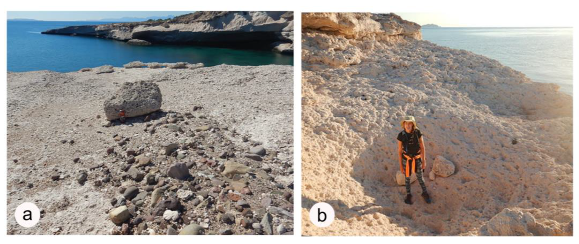
16]. Overall, the island’s coastal geology is dominated by andesite, a volcanic rock that forms from surface flows. Pliocene and Pleistocene limestone deposits created between 4.5 and 1.8 million years ago occur in scattered localities around the periphery of the island, most notably over a lateral distance of 1.5 km represented by a succession of four marine terraces on the east shore at Arroyo Blanco. The lowest terrace closest to the present shore is the 12 m terrace that sat at sea level approximately 125,000 years ago [17]. Conditions under which flat-lying limestone layers were pried loose from the outer edge of the uplifted terrace and transported landward by as much as 25 m are attributed to a succession of Holocene hurricanes that occurred over the last 10,000 years (6). Several of the largest limestone slabs that sit loose on the terrace are distinctive in profile. An important question is to what extent could contemporary storms further shift such blocks and otherwise contribute to ongoing coastal erosion.

3. Materials and Method

The coastal boulder deposit (CBD) on the elevated 12 m terrace at Arroyo Blanco on Isla del Carmen was first identified during a visit in March 2016. This site was revisited in February 2018, during which data were collected in preparation for a published report [6]. No substantial changes in the nature of the CBD were found to have occurred during the intervening two years. Travel restrictions related to the COVID-19 pandemic caused a delay in returning to the site after the passage of Category 2 Hurricane Olaf in September 2021. With the passage of Category 2 Hurricane Kay on 8 September 2022, an opportunity was taken to revisit the site at Arroyo Blanco in order to check for possible changes to the structure of the 12 m terrace, as well as any collateral damage of a biological nature. The tracks of the two storms with landfalls on the outer Pacific shores of the Baja California peninsula were very similar. A reconnaissance trip to Arroyo Blanco took place on 30 September 2022, two weeks after the storm, and follow-up visits to conduct a more detailed survey occurred on 12 and 13 October 2022.

3.1. Onshore Data Collection

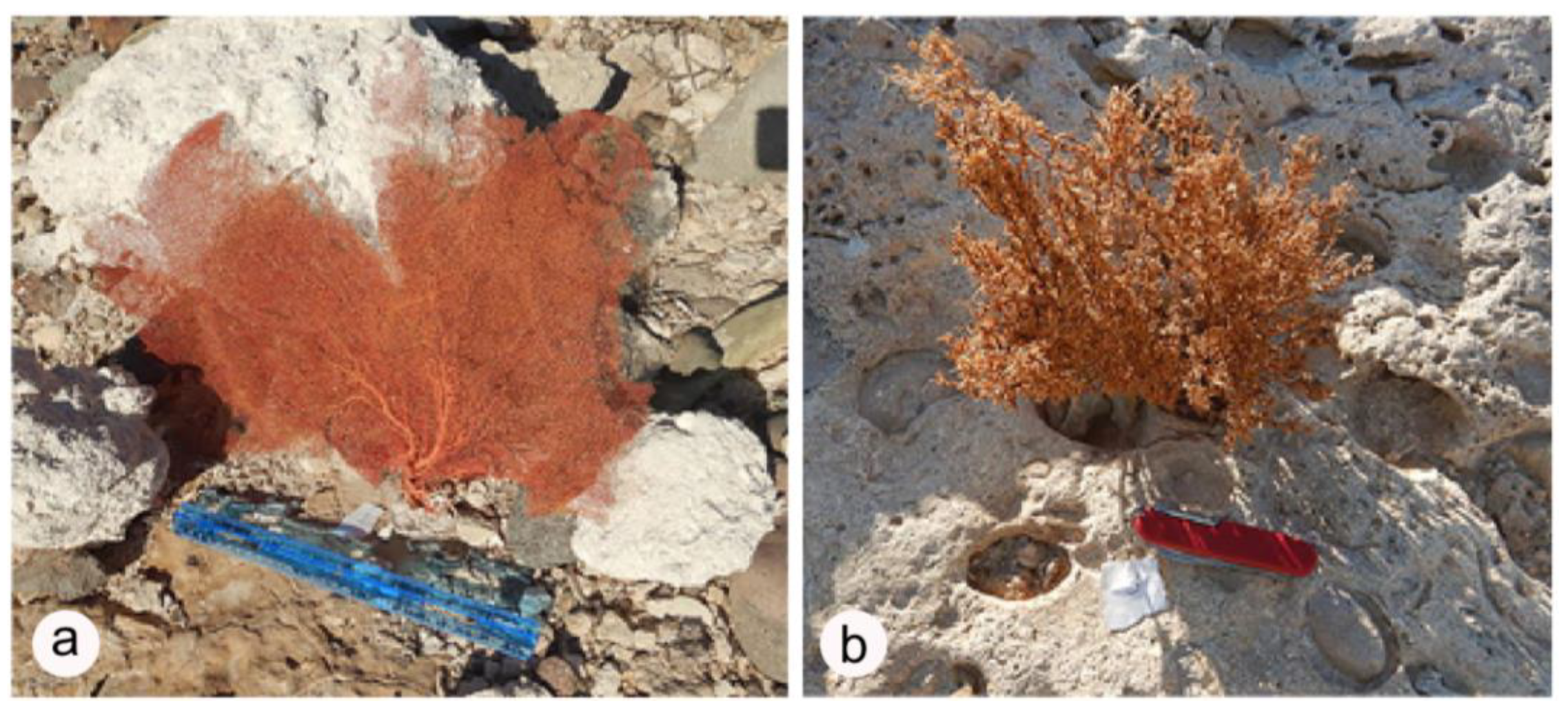
Extensive field photos were taken to record aspects of physical erosion as well as biological issues related to the desiccation of land plants that were growing on the limestone platform and the spread of marine organisms ripped from the seabed below and spread as detritus across the same area. Dead bushes were easy to recognize because of their brown color in the absence of any chlorophyl. The main plant affected in this way was the Gulf Star Violet (Stenotis mucronate). The most apparent phenomenon relevant to disturbance of marine life was in connection to the brightly colored, red-orange sea fan belonging to the species Pacifigorgia adamsi. Using a Nikon CoolPix W300TM (Nikon-products, Japan), photos were made showing a large number of desiccated plants and 44 sea fans across a surface area of roughly 6000 m2. Among these, the location on the platform of a half dozen representative land plants and a dozen of the largest sea fans were established by latitude and longitude and mapped. Two kinds of measurements were recorded at 18 spots on the terrace platform. The distance of a given biological feature to the seaward lip of the platform was measured using a 9 m rope that could be extended in marked stages to the closest edge of the platform. The map location and elevation above mean sea level of a given biological feature were recorded using a Global Positioning System Gamin Etrex 22X TM unit (USA production headquarters in Olathe, Kansas). In addition, standing pools of seawater were photographed, some of which had begun to precipitate salt crystals after more than a month of exposure under the sun. Finally, the survey concluded with notes and photographic evidence of physical erosion.

3.2. Subtidal Observations

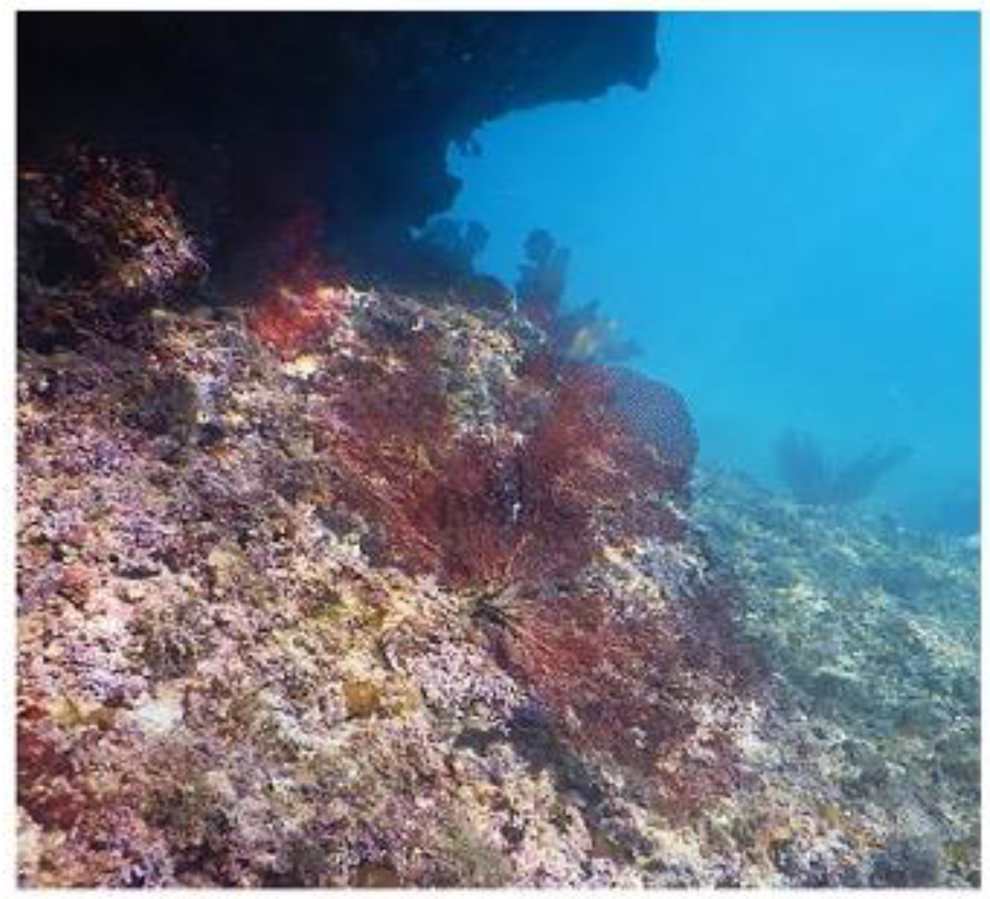
Because sea fans were detached from their anchorage on the rocky seabed adjacent to the 12 m limestone terrace, it was necessary to investigate the shallowest water depth at which the same gorgonians could be found living in place. This was accomplished by diving to the seabed and photographing what could be found there. The same kind of camera that had been used ashore was employed for this purpose.

4. Results

4.1. Base Map

Figure 2 shows the base map created to plot raw data marking the position of selected observation points on the 12 m limestone terrace at Arroyo Blanco on the east shore of Isla del Carmen. Refer to Figure 1b for the location of the terrace on the island.

4.2. Check for Disruption of Limestone Slabs

No significant movement of previously displaced limestone slabs was detected between this visit and the February 2018 visit to Arroyo Blanco. In terms of geomorphic processes, the most extreme mode of erosion on the 12 m limestone terrace is demonstrated by upended limestone layers that were pried loose from the seaward edge by the hydraulic pressure of storm waves forcing water into the seams between horizonal cracks in stratified layers. The size of the mobilized slabs varies depending on the thickness of layers involved and variation in the spacing of vertical joints in the limestone. The tilted layers of limestone tend to be rectilinear in shape and may be described as individual blocks having measurable dimensions in three axes.
In particular, it was found that the largest such distinctive block with an estimated weight of 28 metric tons [6] showed no evidence of a change in position as a result of disturbance from Hurricane Kay. This is verified by a comparison of the same block and surrounding lesser blocks from 2018 and 2022 (Figure 3a,b).
The implication of such a direct comparison is that Hurricane Kay as a Category 2 storm in 2022 (or the preceding Hurricane Olaf as a comparable Category 2 storm in 2021) lacked the punch to shift the largest blocks compared to the intensity of the storm that first detached them from flat-laying strata during some unknown event that was first described in 2018. That said, observations based on much smaller pieces of limestone that had a coloration not previously noticed anywhere on the terrace suggest that waves spilling onto the elevated platform during Hurricane Kay were sufficient to detach and mobilize pieces of limestone roughly 30 × 30 × 30 cm in size. It is noteworthy that the annual winter winds that blow out of the north have no discernable effect on the east or west facing shores of Isla del Carmen in terms of sea swell and generated wave shock [15]. During the winter season, north-facing shores are most vulnerable to erosion throughout the gulf region.

4.3. Evidence from Displaced Sea Fans

The delicate sea fan Pacifigorgia adamsi makes a striking visual impression on divers because of its frond-like appearance and distinctive red–orange coloration. After the passage of Hurricane Kay, it was even more striking to find that large numbers of this sea fan were detached from the holdfast that keeps them fastened to the rocky seabed. Wave action that crashed against the east shore of Isla del Carmen mostly spread torn pieces of the fans across the surface of the adjacent 12 m limestone terrace. The map in Figure 2 (localities 1 to 12 labeled in red) denotes the location of a dozen such fans out of the 44 specimens observed strewn across the area. The example of an especially large fan with its characteristic rounded silhouette and basal attachment area still intact is shown from location 1 in Figure 4a.
According to data in Table 1, the displaced sea fan at locality 1 was carried 13 m inland and left at an elevation of 7.5 m above mean sea level. Based on mapped examples (Figure 2), the average distance transported inland for a dozen fans is 28.3 m and the average elevation above mean sea level is 7.2 m.

4.4. Evidence from Desiccated Land Plants

In contrast to the vivid coloration of sea fans left on the limestone terrace, the widespread disturbance of many herbaceous perennials represented by the Gulf Star Violet (Stenotis mucronate) formerly alive on the same surface was equally striking from their brown coloration devoid of any chlorophyl. The map in Figure 2 (localities 1 to 6, labeled in green) plots the location of a half dozen such plants out of a large number observed across the area. The example of a bush with a typical woody stem that grew in place at location 3 is illustrated in Figure 4b. Based on data in Table 2, that particular plant grew 14 m from the nearest eroded edge of the platform at an elevation 2.5 m above mean sea level. Based on mapped samples of a half dozen plants, the average distance of those particular lants growing in place was 33 m from the nearest seaward edge of the platform with an average elevation above mean sea level at 7 m.
As many as eight species belong to the genus Stenotis, herbaceous perennials that are endemic to the southern Baja California peninsula [18]. Occurrence of the species Stenotis mucronate, with its characteristic small and four-petaled white flowers, is reported from the southern end of Isla del Carmen by botanist Jon P. Rebman [19]. Direct exposure to seawater washed ashore by waves or carried by prolonged ocean spray would be deleterious to the plant.

4.5. Evidence from Standing Pools of Seawater

More than a month after the passage of Hurricane Kay, while doing survey work on the limestone terrace 12 and 13 October 2022, it was still possible to find standing pools of saltwater that were undergoing evaporation under direct exposure to the sun. Figure 5a shows an example of a shallow pool covering approximately one square meter in area. A close-up photo from a shallower pool (Figure 5b) shows the formation of salt crystals in their characteristic cubic habit. The die-off of a large number of plants spread across the central part of the limestone terrace (see Figure 2) indicates that subjugation to seawater splash was widespread on the terrace during Hurricane Kay.

4.6. Evidence of Short-Term and Long-Term Erosion on the Limestone Terrace

Other key spots on the 12 m limestone terrace at Arroyo Blanco demonstrate the effects of mechanical erosion in a dramatic way. At the south end of the terrace (Figure 2, locality 1 labeled in blue), a large boulder acted as a protective barrier against wave shock that sheltered an array of rock cobbles in a kind of shadow on the leeward side of the boulder (Figure 6a). The axis of the elongated cobble field behind the boulder suggests that waves splashed onto the terrace from the southeast. The boulder itself was too heavy to be moved by wave impact, but the arrival of successive storm waves cleared the surface of rock rubble in front of and on either side of the boulder. Where additional rock scour is indicated (Figure 2, locality 2 marked in blue), the leading edge of the limestone terrace has already been stripped of its upper layers such that the cliff face has receded farther landward than adjacent parts of the cliff to the north and south. Here, potholes as large as 2 m in diameter are eroded in the limestone (Figure 6b). These are similar to potholes that erode in riverbeds during floods. Riverine potholes typically include pebbles or cobbles trapped within depressions that swirl around under the force of violently rushing water in such a way that the holes continue to deepen through physical abrasion of stone against stone.
The mechanics of this process are well understood in the context of riverine erosion and were tested long ago under laboratory conditions [20], and research on potholes in riverine settings is ongoing [21,22]. It is notable that the terrace potholes at Arroyo Blanco retain small boulders within them (Figure 6b). The phenomenon is unusual in coastal settings, but has been documented elsewhere in marine coastal settings [23,24]. The size of the potholes suggests that they have existed for some time, but their proximity near the seaward edge of the terrace also indicates that erosion could be reactivated at any time by the next storm. These potholes are situated 6.5 m from the front of the terrace at an elevation of 5.5 m above mean sea level. The boulder shown in Figure 6a is located 15 m from the seaward edge of the terrace and 8 m above mean sea level.

4.7. Investigation of the Sea-Fan Habitat off the Limestone Terrace

Detachment of sea fans from the seabed as a result of vigorous wave action during Hurricane Kay and the wash-over of sea fans onto the adjacent limestone terrace demonstrates widespread evidence of biological disruption. Thus, it was necessary to investigate the natural habitat of the species Pacifigorgia adamsi. In particular, establishing the upper limit of growth of these fans in subtidal conditions is relevant. As seen in Table 1, the elevation of sea fans washed ashore was found on average to be more than 7 m above mean sea level. Figure 7 shows the local habitat of the distinctive sea fans growing in place on a rocky slope below the plunging limestone sea cliffs at Arroyo Blanco. The upper limit of growth was found to be about 5 m below the surface. Some survivors show evidence of bits of sea fan having been torn away from the normally rounded margin.

5. Discussion

Hurricanes, as they are called in the Atlantic and eastern Pacific basins, are atmospheric disturbances of extraordinary violence fueled by elevated sea-surface temperatures (SSTs) that surpass 26.6 °C in subtropical regions to spawn cyclonic depressions on a seasonal basis [25]. The Saffir–Simpson Hurricane Wind Scale is a 1 to 5 rating based on a storm’s sustained wind speed [26]. Winds generated by a rotating system in a Category 2 storm such as Hurricane Kay achieve wind speeds between 154–177 km/h and are considered extremely dangerous, but a Category 3 storm surpassing 178 km/h in wind speed is expected to cause devastating damage. Category 4 and 5 storms with wind speeds that exceed 209 km/h and 252 km/h, respectively, can cause catastrophic damage.
The present study follows in the tradition of investigations pioneered by Ball et al. from 1967 [27], in which parts of South Florida were studied for physical alterations that left sedimentary deposits ashore after the passage of Hurricane Donna as a Category 3 storm. There exist more than a dozen localities along the western shores and islands in the Gulf of California that qualify as coastal boulder deposits (CBDs) attributed to major storms that have struck since the start of the Pliocene Warm Period 4.5 million years ago and repeated during intervals of the Pleistocene and Holocene epochs until today [25]. The CBD on the 12 m limestone terrace at Arroyo Blanco represents but one of these localities [6]. Limited historical records indicate that 95 storms have struck Mexico’s Baja California peninsula since 1950 [28]. Storm chasers risk their lives to follow tornados through tornado alley in the American Midwest, but few are foolish enough to camp out on an exposed rocky shore to observe the landfall of a hurricane. The challenge is to visit a known locality where such storms have struck previously but as soon as possible after the passage of a given storm. The 12 m limestone terrace at Arroyo Blanco on the east shore of Isla del Carmen is an ideal locality for this sort of surveillance. The locality (Figure 1b) is far enough from populated areas that the terrace CBD remains undisturbed by human contact, but close enough to allow for periodic checks. What can be deduced about the influence of Hurricane Kay is that it did not have sufficient power to move the largest limestone slabs that were previously interpreted to have been displaced by earlier storms. However, smaller pieces of limestone with a distinct coloration were found to be scattered across the terrace. Examples are illustrated by two white chunks of stone that prop up the sea fan in Figure 4a. The coloration matches no bedding surface elsewhere on the terrace and is assumed to have been eroded from a stratum in the subtidal zone.
Isla del Carmen is protected as part of the Loreto Bay National Marine Park, which also includes four other islands. These have no permanent human populations but are visited by boaters and kayakers mostly on day excursions. Although there is no substantial infrastructure that is vulnerable to damage by hurricanes, an ongoing program for monitoring changes in coastal geomorphology is desirable from a scientific point of view. In other parts of the world where large human populations live close to the coast, such a monitoring program is even more important. The essential groundwork for such environmental monitoring is already in place in the Philippines and mainland China, where typhoons that impact shorelines do significant damage to infrastructure [10,11]. The same attention is needed for conservation zones and nature preserves.

6. Conclusions

Under the continuing impact of global warning, major storms of hurricane intensity are a growing problem that not only affects the coastal zone of Mexico’s Baja California peninsula but other areas around the world. Surveillance studies of the kind demonstrated herein are a useful way to monitor the effect and growing danger of big storms.
What can be concluded with certainty is that wind-driven waves powered by Hurricane Kay disturbed the seabed directly adjacent to the limestone terrace, detaching sea fans from a depth no less than 5 m and sending them up and over sea cliffs to be left on the terrace as biological detritus at elevations on average more than 7 m above mean sea level (see Table 1).
Likewise, seawater also splashed onto the limestone terrace and accumulated as widespread pools at an average elevation 7 m above mean sea level. Exposure to seawater killed bushes, most commonly Gulf Star Violets (Stenotis mucronate). Some were growing in place as much as 33 m inland from the outer edge of the limestone terrace (see Table 2). The plants also show that relatively long intervals by human standards may transpire before the repetition of a major storm.
The survey also detected previously unrecognized evidence for large potholes eroded on the limestone terrace that could only have formed under the influence of major storms. Such potholes are more commonly found in riverbeds where flooding is a major influence but are not widely recognized on rocky shores.

Author Contributions

The first author (M.E.J.) was responsible for data curation and original draft preparation. The second author (G.C.) was in charge of conceptualization and methodology. All authors have read and agreed to the published version of the manuscript.

Funding

This research received no external funding.

Institutional Review Board Statement

Not Applicable.

Informed Consent Statement

Not Applicable.

Data Availability Statement

All original data pertinent to this study are provided in the published results.

Acknowledgments

Elena Monleon assisted with survey work during the second visit to the 12 m terrace at Arroyo Blanco from 12–13 October 2022. The authors are grateful to Sula Vanderplank (Centro de Estudios del Medio Ambiente, Loreto) for help identifying the desiccated land plants on the shores of Isla del Carmen. Two readers offered peer reviews with useful comments that led to the improvement of this contribution.

Conflicts of Interest

The authors declare no conflict of interest.

References

  1. Avila, L. The 2015 eastern North Pacific hurricane season: A very active year. Weatherwise 2016, 69, 36–42. [Google Scholar] [CrossRef]
  2. Muriá-Vila, D.; Jaimes, M.Á.; Pozos-Estrada, A.; López, A.; Reinoso, E.; Chávez, M.M.; Peña, F.; Sánchez-Sesma, J.; Lóppez, O. Effects of Hurricane Odile on the infrastructure of Baja California Sur, Mexico. Nat. Hazards 2018, 9, 963–981. [Google Scholar] [CrossRef]
  3. Tierney, P.W.; Johnson, M.E. Stabilization role of crustose coralline alga during Late Pleistocene reef development on Isla Cerralvo, Baja California Sur (Mexico). J. Coast. Res. 2012, 59, 503–519. [Google Scholar]
  4. Callahan, G.; Johnson, M.E.; Guardado-France, R.; Ledesma-Vázquez, J. Upper Pleistocene and Holocene storm deposits eroded from the granodiorite coast on Isla San Diego (Baja California Sur, Mexico). J. Mar. Sci. Eng. 2021, 9, 555. [Google Scholar] [CrossRef]
  5. Johnson, M.E.; Johnson, E.M.; Guardado-France, R.; Ledesma-Vázquez, J. Holocene hurricane deposits eroded as coastal barriers from andesite sea cliffs at Puerto Escondido (Baja California Sur, Mexico). J. Mar. Sci. Eng. 2020, 8, 75. [Google Scholar] [CrossRef]
  6. Johnson, M.E.; Ledesma-Vázquez, J.; Guardado-Grance, R. Coastal geomorphology of a Holocene hurricane deposit on a Pleistocene marine terrace from Isla Carmen (Baja California Sur, Mexico). J. Mar. Sci. Eng. 2018, 6, 108. [Google Scholar] [CrossRef]
  7. Johnson, M.E.; Guardado-France, R.; Johnson, E.M.; Ledesma-Vázquez, J. Geomorphology of a Holocene hurricane deposit eroded from rhyolite sea cliffs on Ensenada Almeja (Baja California Sur, Mexico). J. Mar. Sci. Eng. 2019, 7, 193. [Google Scholar] [CrossRef]
  8. Guardado-France, R.; Johnson, M.E.; Ledesma-Vázquez, J.; Santa Rosa-del Rio, M.A.; Herrera-Gutiérrez, A.R. Multiphase storm deposits eroded from andesite sea cliffs on Isla San Luis Gonzaga (Northern Gulf of California, Mexico). J. Mar. Sci. Eng. 2020, 8, 525. [Google Scholar] [CrossRef]
  9. Available online: https://en.wikipedia.org/wiki/Hurricane_Kay_2022 (accessed on 29 January 2022).
  10. Holden, W.N.; Marshall, S.J. Climate change and typhoons in the Philippines: Extreme weather events in the Anthropocene. In Integrating Disaster Science and Management; Elsevier: Amsterdam, The Netherlands, 2018; pp. 407–421. [Google Scholar]
  11. Yin, J.; Yin, Z.; Xu, S. Composite risk assessment of typhoon-induced disaster for China′s coastal area. Nat. Hazards 2013, 69, 1423–1434. [Google Scholar] [CrossRef]
  12. Ledesma-Vázquez, J.; Johnson, M.E.; Gonzalez-Yajimovich, O.; Santamaría-del-Angel, E. Gulf of California geography, geological origins, oceanography and sedimentation patterns. In Atlas of Coastal Ecosystems in the Western Gulf of California; Johnson, M.E., Ledesma-Vázquez, J., Eds.; University of Arizona Press: Tucson, AZ, USA, 2009; pp. 1–10. ISBN 978-0-8165-2530. [Google Scholar]
  13. Merrifield, M.A.; Winant, C.D. Shelf-circulation in the Gulf of California: A description of the variability. J. Geophys. Res. 1989, 94, 133–160. [Google Scholar] [CrossRef]
  14. Bowen, T. On Desert Shores: Archaeology & History of the Western Midriff Islands in the Gulf of California; University of Utah Press: Salt Lake City, UT, USA, 2022; 313p, ISBN 9781647690380. [Google Scholar]
  15. Backus, D.H.; Johnson, M.E.; Ledesma-Vázquez, J. Peninsular and island rocky shores in the Gulf of California. In Atlas of Coastal Ecosystems in the Western Gulf of California; Johnson, M.E., Ledesma-Vázquez, J., Eds.; University of Arizona Press: Tucson, AZ, USA, 2009; pp. 10–11. ISBN 978-0-8165-2530-0. [Google Scholar]
  16. Carreño, A.L.; Helenes, J. Geology and ages of the islands. In A New Island Biogeography of the Sea of Cortés; Case, T.J., Cody, M.L., Ezurra, E., Eds.; Oxford University Press: Oxford, UK, 2002; ISBN 0195133463. [Google Scholar]
  17. Eros, M.E.; Johnson, M.E.; Backus, D.H. Rocky shores and development of the Pliocene-Pleistocene Arroyo Blanco Basin on Isla Carmen in the Gulf of California, Mexico. Can. J. Earth Sci. 2006, 43, 1149–1164. [Google Scholar] [CrossRef]
  18. Rebman, J.P.; Roberts, N.C. (Eds.) Baja California Plant Field Guide. San Diego Natural History Museum, 3rd ed.; Sunbelt Publications: San Diego, CA, USA, 2012; 451p, ISBN 978-0-916251-18-5. [Google Scholar]
  19. Report on the Gulf Star Violet (Stenotis mucronate) posted to iNaturalist by botanist Jon R. Rebman. Available online: https://www.inaturalist.org/observations/18557864 (accessed on 29 January 2023).
  20. Alexander, H.S. Pothole erosion. J. Geol. 1932, 40, 289–384. [Google Scholar] [CrossRef]
  21. Ji, S.; Li, L.; Zeng, W. The relationship between diameter and depth of potholes eroded by running water. J. Rock Mech. Geotech. Eng. 2018, 10, 818–831. [Google Scholar] [CrossRef]
  22. Ji, S.; Zeng, W.; Li, L.; Ma, Q.; Feng, J. Geometrical characterization of stream potholes in sandstone from the Sunzi River (Chongquing, China) and implications for the development of bedrock channels. J. Asian Earth Sci. 2019, 173, 374–385. [Google Scholar] [CrossRef]
  23. Swinnerton, A.C. Observations on some details of wave erosion: Wave furrows and shore potholes. J. Geol. 1927, 35, 171–179. [Google Scholar] [CrossRef]
  24. Abbott, A.T.; Pottratz, S.W. Marine pothole erosion, Oahu, Hawaii. Pac. Sci. 1969, 23, 276–290. [Google Scholar]
  25. Johnson, M.E. Geological oceanography of the Pliocene Warm Period: A review with predictions on the future of global warming. J. Mar. Sci. Eng. 2021, 9, 1210. [Google Scholar] [CrossRef]
  26. National Weather Service. Available online: https://www.weather.gov/mfl/saffirsimpson (accessed on 29 January 2023).
  27. Ball, M.M.; Shinn, E.A.; Stockman, K.W. The geologic effects of Hurricane Donna in South Florida. J. Geol. 1967, 75, 583–597. [Google Scholar] [CrossRef]
  28. Johnson, M.E. Baja California’s Coastal Landscapes Revealed, Excursions in Geologic Tie and Climate Change; University of Arizona Press: Tucson, AZ, USA, 2021; ISBN 13: 978-0-8165-4252-9. [Google Scholar]
Figure 1. Map showing Mexico’s Baja California peninsula and adjacent Gulf of California: (a) Mexico with key cities indicated and inset box to show map enlargement of the Loreto area; (b) Isla del Carmen near Loreto on the peninsular mainland with the location of the 12 m limestone terrace marked on the island’s eastern shore.
Jmse 11 00323 g001
Figure 2. Map covering approximately 6000 m2 on the 12 m limestone terrace adjacent to the access beach at Arroyo Blanco on the east coast of Isla del Carmen. The marked locations for displaced sea fans and desiccated land plants are numbered for reference to data supplied in Table 1 and Table 2. Key features showing the effect of wave scour on the platform also are marked.
Jmse 11 00323 g002
Figure 3. Before and after photos showing some of the largest limestone blocks on the 12 m terrace at Arroyo Blanco: (a) Upturned limestone block photographed from the front at midday in February 2018 with person for scale; (b) Same block photographed in the distance from the side (upper right) in context with smaller blocks early on a September day in 2022.
Jmse 11 00323 g003
Figure 4. Evidence for biological disruptions observed on the 12 m limestone terrace at Arroyo Blanco from the east coast of Isla del Carmen: (a) Displaced sea fan (Pacifigorgia adamsi) sitting upright against rocks on the rock platform at locality 1 on the map in Figure 2 (12-inch ruler for scale = 30 cm); (b) Completely desiccated land plant identified as the Gulf Star Violet (Stenotis mucronate) grew in place on the rock platform at locality 3 on the map in Figure 2 (pocket knife for scale = 9 cm).
Jmse 11 00323 g004
Figure 5. Evidence from a saltwater pool on the coastal terrace at Arroyo Banco: (a) Shallow depression on the limestone surface filled with seawater (blue ruler = 30 cm); (b) Close-up of individual salt crystals recovered from the brine of another pool exhibiting a characteristic cubic habit (maximum crystal size is 5 mm in diameter).
Jmse 11 00323 g005
Figure 6. Photos showing evidence of mechanical erosion on the 12 m limestone terrace at Arroyo Blanco: (a) Large limestone boulder that formed a protective barrier against wave scour that left a line of cobbles undisturbed on the leeward side; (b) Large pothole eroded in limestone near the seaward edge of the limestone terrace, including small boulders that would have swirled around the inner margin during the impact of each wave (person for scale).
Jmse 11 00323 g006
Figure 7. Underwater photo showing the natural habitat of the sea fan Pacifigorgia adamsi growing in place on the seabed at an upper depth limit of about 5 m.
Jmse 11 00323 g007
Table 1. Sea fans (Pacifigorgia adamsi) detached from the seabed and deposited on the 12 m limestone terrace at Arroyo Blanco on the eastern coast of Isla del Carmen during Hurricane Kay in September 2022.
Specimen NumberDistance to Edge
of the Terrace (m)
Elevation Above Mean Sea Level (m)
1137.5
2359
3388
4399.5
5375
6246.5
7157
8145
9639
10157
11276
12207
Mean28.37.2
Table 2. Desiccated land plants represented by the Gulf Star Violet (Stenotis mucronate) destroyed by exposure to seaward during Hurricane Kay on the 12 m limestone terrace at Arroyo Blanco on the eastern coast of Isla del Carmen in September 2022.
Specimen NumberDistance to Edge
of the Terrace (m)
Elevation Above Mean Sea Level (m)
1137.5
2359
3388
4399.5
5375
6246.5
Mean317.5
Disclaimer/Publisher’s Note: The statements, opinions and data contained in all publications are solely those of the individual author(s) and contributor(s) and not of MDPI and/or the editor(s). MDPI and/or the editor(s) disclaim responsibility for any injury to people or property resulting from any ideas, methods, instructions or products referred to in the content.

