Review

Environmental Impacts and Challenges Associated with Oil Spills on Shorelines

Department of Building, Civil and Environmental Engineering, Concordia University, Montreal, QC H3G 2W1, Canada
*
Author to whom correspondence should be addressed.
J. Mar. Sci. Eng. 2022, 10(6), 762; https://doi.org/10.3390/jmse10060762
Submission received: 31 March 2022 / Revised: 21 May 2022 / Accepted: 29 May 2022 / Published: 31 May 2022
(This article belongs to the Special Issue Reviews in Marine Environmental Science and Engineering)

Abstract

:
Oil spills are of great concern because they impose a threat to the marine ecosystem, including shorelines. As oil spilled at sea is transported to the shoreline, and after its arrival, its behavior and physicochemical characteristics change because of natural weathering phenomena. Additionally, the fate of the oil depends on shoreline type, tidal energy, and environmental conditions. This paper critically overviews the vulnerability of shorelines to oil spill impact and the implication of seasonal variations with the natural attenuation of oil. A comprehensive review of various monitoring techniques, including GIS tools and remote sensing, is discussed for tracking, and mapping oil spills. A comparison of various remote sensors shows that laser fluorosensors can detect oil on various types of substrates, including snow and ice. Moreover, current methods to prevent oil from reaching the shoreline, including physical booms, sorbents, and dispersants, are examined. The advantages and limitations of various physical, chemical, and biological treatment methods and their application suitability for different shore types are discussed. The paper highlights some of the challenges faced while managing oil spills, including viewpoints on the lack of monitoring data, the need for integrated decision-making systems, and the development of rapid response strategies to optimize the protection of shorelines from oil spills.

1. Introduction

Oil from accidental discharges during transportation, tank ruptures, offshore exploration, and leakage from underwater pipelines are known to adversely affect the marine habitat and community [1]. The situation is compounded and worse if spilled oil reaches the shoreline or coast as biological productivity is higher at these sites, and oil stranded on shorelines may persist for extended periods. According to oil spill intelligence reports, major hotspots primarily occurred in the north-eastern USA, the Gulf of Mexico, and the Mediterranean Sea [2]. The intensity of spilled events depends on the type and volume of spilled oil. The “International Tanker Owners Pollution Federation” (ITOPF) categorizes spills into the small scale (<7 tonnes), medium-scale (7–700 tonnes), and large scale (>700 tonnes) [2]. With the advent of new ships and improvements in safety protocols, in contrast to the period 2000–2009, statistics have shown a reduction of 71.7% and 43.75% for medium and large scale spills during the period 2010–2019 [3]. However, while the frequency of incidents has declined over the past decades, mitigations and remediation of oil spills remain a challenge.
When the spilled oil enters the marine environment, it undergoes chemical changes (e.g., advection, dispersion, and biodegradation) and physical transformation under the influence of various environmental factors (e.g., temperature, wind, and wave currents) [4]. The oil spilled into marine water often reaches the shore and becomes stranded because of tidal currents and wind [3]. Shorelines provide a buffer between sea and land, particularly mangroves and saltmarshes, which provide erosion protection and defense against floods. In addition, shorelines are a habitat for many permanent dwellers, and some animals rely on shoreline resources [5]. Assessing the impact of stranded oil on shorelines is the first step toward understanding the risk and strategizing the cleanup techniques. The freshly spilled oil, including crude oil, comprises complex hydrocarbons with varying physical and chemical characteristics and molecular weight. The oil constitutes a large proportion of low boiling compounds that are more readily water-soluble and easily spread over the sea surface because of low viscosity [6]. Over time, the oil slick undergoes weathering processes (e.g., evaporation, dissolution, and photo-oxidation) in which the oil becomes more viscous and volatile [7]. Because of physical and chemical changes in crude oil properties, the weathered product of residual oil that reaches the shoreline has different properties than freshly spilled oil [8]. The environmental conditions and shoreline topography also play a crucial role in influencing the shoreline’s susceptibility to oil. Successful management of oil spill response (OSR) operations, including cleanup requires the simultaneous consideration of numerous factors, such as weather conditions, type of oil, shoreline type, and time sensitivity (from incident to OSR) [8]. Thus, selecting the optimal mitigation and remediation strategies depends on the scientific knowledge of oil recovery and effective monitoring protocols.
There are also many other challenges, such as local community resilience to spills and communication gaps, which can hinder the remediation of oil spills. Many studies focus on the oil spill issue and associated control techniques in marine water, but very few studies address the environmental impact of oil spills on shorelines. This paper critically examines the ecological impact of oil spills on shorelines and their fate under various environmental conditions and seasonal variations. The article also presents a comprehensive review of various monitoring and control techniques for oil recovery. Based on a synthesis of findings and challenges in protecting shorelines, the outlook of oil spill response strategies is discussed.

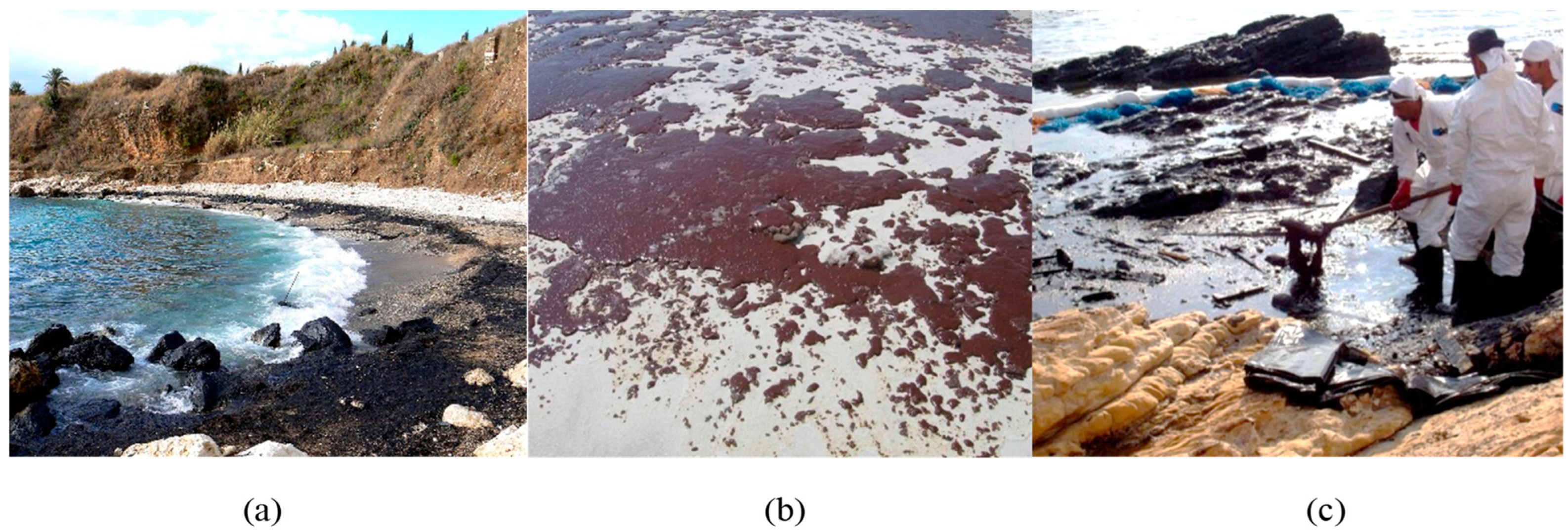
2. Vulnerability of Shorelines to Oil Spill Impacts

Oil spilled on shorelines can cause major habitat damage and pose serious threats to all living organisms living on and within shorelines [9]. The potential effects of oil contamination on biota can vary from species to species [10]. Exposure to spilled oil can affect organisms externally through the skin or internally via direct inhalation and ingestion. Animals most affected by oil are seabirds, turtles, and marine mammals (e.g., sea otters and seals) [11]. However, it is not easy to examine the exact impact on seabirds because these species can travel the greatest distance searching for food and during breeding seasons [12]. It is crucial to analyze the post-spill impact in the absence of accurate data related to age structures and the birds’ possible origin [9]. For hatching and nesting, most sea turtles head to the shorelines and sandy beaches where they may become oiled directly or through contaminated food [12]. Moreover, turtles’ eggs and the newly hatched juveniles are vulnerable to shoreline oil contamination during their nesting season [13]. Seals and sea lions are at risk when surfacing and hauling onto the beach [14]. Marine crustaceans (e.g., crabs) are susceptible to oil through direct exposure as they dig into oiled sediments and ingestion, which causes impaired movement, reproductive failure, and death [11].
The oil dissipates more slowly and can persist for several years in sediments even after cleanup processes [8]. Therefore, these oil-contaminated sediments may increase the exposure risk to aquatic ecosystems and human health [15]. Many studies reported that residual oil could persist for a longer duration in sediments depending on the geographical conditions and hydrodynamic properties [15,16,17,18]. For example, the Σ16PAHs (polycyclic aromatic hydrocarbons) were found in sediments eleven years after the Tasman oil spill incident (Karachi, Pakistan) and only declined by ∼47 times compared with the levels when the oil spill occurred [15]. In the case of the Hebei Spirit oil spill (west coast, Korea), long PAH persistence was observed in muddy sediments (reduction rate k = 0.001) in comparison to sandy sediments (k = 0.016), leading to the conclusion that sediment type could also influence the fate of spilled oil [16]. In addition, oil chemical composition changes in sediments would help to estimate the degradation rate and evaluate the risk of oil spills for the entire ecosystem [17]. Crude oil predominantly comprises aromatics, alkanes, asphaltenes, and cycloalkanes. The aromatics, such as PAHs, are considered more toxic to the environment. However, it is difficult to find the actual composition of oil spilled because of the weathering process. Therefore, Ferguson et al. [17] suggested that known spill location, time, and volume would determine the original chemical constituents and pollutant concentrations.
The most sensitive habitats that could be at great risk of oil contamination are coral reefs, mangroves, and saltmarshes [19]. All three ecological habitats provide coastal protection and feeding/nursery grounds for many invertebrate and fish species [1]. Coral reefs are highly sensitive to oil contamination and can take a long time to recover [19]. Oil floating on the water’s surface can be deposited directly on coral habitats when the intertidal zone experiences low tide [20]. Mangroves are trees and shrubs usually found in coastal and estuarine shorelines in tropical and sub-tropical regions across the globe [21]. Mangroves are significant to the ecology as they provide shoreline protection to inland areas from intense storms and habitat for various mammals, birds, insects, plants, and algae attached to the roots of trees [22]. The oil can adhere to the exposed surface and roots of mangrove trees when exposed to the flow of tidal waters [21]. When smothered with oil contamination, plants and animals cannot survive within the mangrove ecosystem [21]. Salt marshes (characterized by salt-tolerant plants and grass) develop in the intertidal zones of muddy shores. They are exposed to high tide water and are vulnerable to floating oil [23]. Salt marshes are found on all tidally influenced coasts of the United States, such as the Atlantic, and Gulf coasts [23]. The oil contamination can badly affect the marshes region by disturbing the food web and causing erosion along the shoreline [23].
Rocky shores are found in some coastal areas and provide habitats to many species [24]. They are usually classified according to tidal zone and wave exposure [25]. Therefore, plants and animals (mostly invertebrates) are vulnerable to the impact of the oil spill [24]. Rocky shores are rugged with variable slopes, fissures, caves, pools, cervices, and surfaces underneath boulders, where habitats experience varying degrees of exposure to water waves [25]. Rocks do not absorb oil, but oil strands on the rock surface may result in the mortality of many species [25]. For example, snails that can shelter in small crevices and Coralline algae commonly found on rock may be bleached and die due to direct contact with oil [26]. Examples of shoreline impacts following major oil spills are outlined in Table 1.

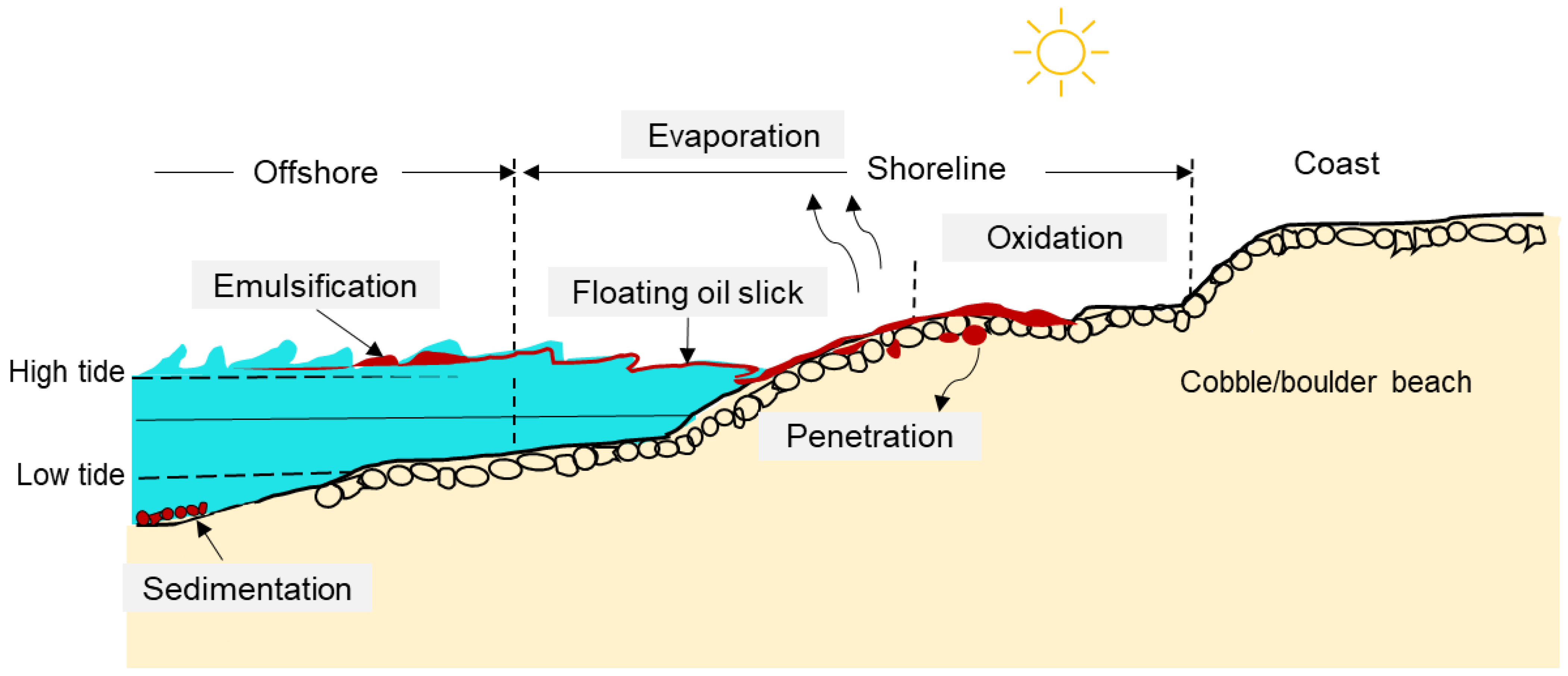
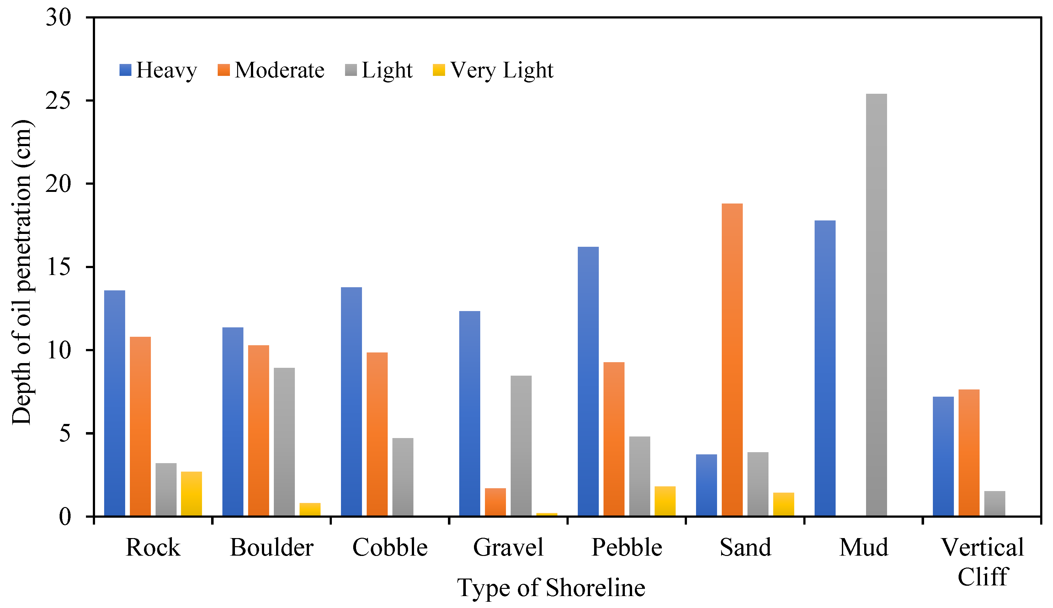
3. Fate and Natural Removal Mechanism of Oil Spill on Shorelines

Mostly on shorelines, spilled oil is transported through water waves as fresh light oils, thin sheens, and residual oil (weathered oil) [18]. If mixed with water, the residual oil is known as an emulsified mixture (also known as mousse), which is more viscous and can resist further weathering processes [28,31]. Additionally, this emulsion tends to have a smothering effect on the shoreline’s habitat at a low tide [18]. The weathering, particularly oxidation, reduces the thick layer of residual oil into small lumps of solid residue, often called tarballs [36], as shown in Figure 1. Examples of other oil residue forms, such as tar-patty, oil stains, and oil sheets on shorelines, are shown in Figure 1.
Shorelines are exposed to both bulk oils from slicks and dissolved phases in water [37]. The fate of oil reaching a shoreline is dependent on various factors, including the shore’s topography and composition (e.g., rocks, sand, fine or coarse-grained), exposure of the residual oil to waves and tides (low and high), characteristics of the oil (composition, molecular weight, viscosity, solubility) and weather conditions [18]. These characteristics, along with the combination of weathering processes, decide the oil behavior in the context of oil penetration, retention, persistence, remobilization, and translocation (pathway to transport the oil into the environment) [38]. Moreover, transformation is another weathering process that can physically or chemically change stranded oil into other products. One of the prominent transformation processes is photo-oxidation which allows oxygen to combine with carbon in sunlight to transform the floating slicks into new compounds [39]. For instance, during the first few days of the Deepwater Horizon (DWH) oil spill (2010), approximately half of the residual surface oil experienced photo-oxidation and transformed into new partially oxidized chemical compounds [40]. Freeman and Ward [40] found that light sun exposure to the oil could generate water-soluble products, and that was why 3–17% of DWH oil spills dissolved into seawater, the process known as photo-dissolution. Future studies should examine the toxicity risk associated with these UV-induced soluble compounds [38]. Some studies show that photochemistry-based phenomena are more effective in a controlled laboratory environment and are not as practicable in the natural environment because of the variability of factors (e.g., solar irradiance, UV intensity) [40,41]. Other physical natural attenuation processes are advection, dissolution, emulsification, evaporation, dispersion, and sedimentation [8,42,43]. Particularly in the context of shorelines, Wang et al. [8] discussed that evaporation is the dominant mechanism in fine-grained and coarse-grained beaches, followed by particle formation and shoreline stranding. In contrast, particle formation is the dominant weathering process in rocky shorelines, followed by evaporation and dissolution [8].
In some conditions, breaking waves on shorelines can mix floating oil with sand or sediments that are suspended in the surf zone to form various sizes of microscopic and macroscopic agglomerates [44]. Macroscopic sediment oil agglomerates (SOAs) range from a few centimeters to several meters, formed by the interaction between mousse and fine or coarse sediments [45]. The sediment-oil mat (SOM) is formed if the agglomerate size is more than one meter in length [45,46]. Michel and Bambach [47] classified SOM as oily (>40% oil) and sandy (<40% of oil), where oily SOMs can separate oil from the sand and refloat. Both SOAs and SOM can persist in a nearshore ecosystem for years after a spill incident [45]. For example, after five years of the Macondo incident (deep horizon rig oil spill) in the Gulf of Mexico, SOAs and SOM have been found on Alabama’s beach [23]. Whereas microscopic oil particle aggregates (OPAs) formed when fine sediments interact with fresh oil slicks may be rapidly dispersed within the water column, oil stranded within the sediments of shorelines may persist for long periods [47].
Oil is often mixed with sand and sediments on sand shorelines [9]. If this mixture is washed off the shoreline back into the sea, oil sediments may sink and be buried in the seafloor [6]. Sometimes residual oils can penetrate, depending on porosity related to sediment, the viscosity of the oil, and the presence of animal burrows in the area [23]. Permeability and penetration are high for coarse-sized beaches with effective porosity: 0.12−0.46; for fine sediments having the same effective porosity, penetration is low but residual loading is high [8]. For example, pebble/cobble beaches have the highest potential for penetration as there is less fine material to fill the voids. These coarse sediments may form a surface or subsurface oil layer that can persist for a longer duration [48]. Spatial and temporal variations influence the remobilization of sediments on shorelines through mixing energy. The movement will depend on the wave energy and physical characteristics of the sediment. In relatively low-energy environments, stranded oil adhering to the sediment surface may form asphalt pavements [8]. If the residual oil on the shoreline does not transform significantly after several high energy waves and tides, it is considered to be retention [43]. Figure 2 illustrates some of the important weathering processes on cobble/boulder beaches.
Shoreline response operations must take into consideration the amounts of oily waste and the type of shorelines [49]. Etkin [50] noted that oil penetration increased with oiling degree and the type of sediments that influenced porosity while investigating the Exxon Valdez oil spill (1989) along the shoreline in Prince William Sound and Western Alaska, also shown in Figure 3. Thus, the morpho-dynamic behavior of the beach contributed to the burial of the oil in the sediment.
The marine environment comprises a variety of microorganisms (e.g., bacteria, fungi, yeast) that can consume hydrocarbons as their energy source that eventually degrade a large fraction of the oil into carbon dioxide and water [51]. The microbial composition varies for each beach and could degrade the hydrocarbons [52]. This biodegradation process depends on several factors, such as availability of oxygen, level of nutrients, surface area for microbes to degrade oil, temperature, and composition (e.g., molecular weight) of the hydrocarbons [51]. When remobilized from the shore, the oil is small oil droplets or attached to sediment particles. Therefore, the exposed surface of the oil is available for biodegradation by microorganisms in the water column [31]. Thus, this process can only occur at the oil-water interface as oxygen is not available within the oil itself [38]. During the dispersion process, the oil droplets’ surface area to volume ratio increases, thus providing more area for biological activity and enhancing biodegradation [52]. In contrast, a thick layer of oil on the shore and away from water has a limited surface area, making the degradation process difficult [53]. Similarly, anaerobic conditions reduce oil degradation rates, and thus, the oil composition of the residual oil may remain unaltered for prolonged periods of time [38]. In past studies, the impact of hypersaline environments on biodegradation was rarely examined. Recently, Geng et al. [54] studied the influence of hypersaline environments on oil decomposition by examining the oiled sediments at a 50 cm depth on various Gulf beaches, in the USA. Interestingly, it was found that evaporation in the beach pore-water caused the hypersaline sediment environment, which inhibited the oil degradation process. Hence, future studies should consider this factor while examining the oil bioremediation strategies.

4. The Implications of Seasonal Variation with Weathering of Oil Spills on Shorelines

There is a direct impact of weather and climatic conditions on the persistency of spilled oil and its weathering process [55]. Therefore, it is crucial to understand the dynamic nature of spilled oil. Characteristics of spilled oil can change over time and with varying environmental conditions [31]. In a cold environment, oil is more viscous and contains many high molecular weight hydrocarbons that slow the degradation process [55]. During winter, oil spreads on the upper shore of the frozen sediments and limits oil penetration into the soil [56]. However, void spaces in the soils that are not filled with ice may allow spilled oil to infiltrate into the frozen soil. Photo-degradation of oil becomes fast during the summer in the presence of sunlight and warm temperatures, leading to the disappearance of slick; but it would be less important during overcast days [18]. The hydrocarbons that volatilize into the atmosphere are broken down by sunlight into smaller compounds [6].
Ambient temperature influences microorganism growth, which plays a significant role during biodegradation or bioremediation of the oil [52]. The highest biodegradation rates generally occur in soils in the range of 30–40 °C and 15–20 °C in marine environments [18,52]. However, cold-tolerant microorganisms can grow at 0 °C temperature and are widely distributed in the environment at temperatures below 5 °C, which plays a critical role in the in situ biodegradation [56]. A recent analysis of oiled samples from various Arctic beaches in Canada has shown that indigenous microbial communities can degrade hydrocarbons even at low temperatures (4 °C), and the process could be enhanced by simulating the process with nutrients except for ultra-low sulfur oil [52]. However, high-intensity solar radiation and dry environmental conditions inhibit oil degradation on surfaces, such as rocks [38].
Seasonal variations can influence the impact of oil on shorelines and the success of various treatment techniques. For instance, Niu et al. [57] examined the potential oil spill impact in a coastal area of Saint John port, New Brunswick, Canada, under seasonal scenarios. During summer, the prevailing wind from the south transported the oil towards the shoreline, and it quickly became stranded onshore. Moreover, with the application of chemical dispersants, spilled oil was prevented from reaching shore, but the effectiveness of dispersants was different in the winter (25.9%) and summer (35.6%) [57]. The affected area due to oil spills in winter is notably larger, and the effectiveness of dispersant is less than in summer because of the more varied wind direction in winter [57]. However, if an incident occurs during winter, ice forms along the coast in some regions; it can act as a barrier that prevents shoreline oiling [31].
The monsoon season influences the transport of oil slicks to shorelines, mainly observed during oil spills in south Asian countries. Balogun et al. [24] investigated the vulnerability of the coastal area to oil slick trajectory in Kota Tinggi, Malaysia, in the monsoon season. It was found that the movement and transport of oil slicks were highest in the pre-monsoon because of the high ocean current speed and wave speed. The minimum time for the slick to reach the shoreline was 16 hrs during the southwest (SW) monsoon and 24 hrs during the northeast monsoon, which indicated that the emergency response should be prompt during the pre-monsoon season [24]. Suneel et al. [36] examined that during monsoon season, tar balls were observed on various beaches in Maharashtra, Karnataka, Gujrat, and Goa (India) in 2017. Moreover, it was found that due to strong winds and turbulent conditions, oil spill images were not captured by the Sentinel-1 sensor. During SW monsoon, the most vulnerable shorelines are rock-shore, mangroves, and salt-marshes, while muddy shorelines are the least susceptible to the impact of oil spills [24].
Oil spilled onto permafrost (e.g., Arctic region) can impact the microbial populations, thawing processes, moisture regimes, as well as nutrient availability, and soil pH [58]. Most of all, the same amount of oil spilled may have a greater impact in cold regions than on the other environments due to the sensitivity of Arctic ecosystems which are exposed to harsh environmental conditions [59]. Moreover, ice cover influences the weathering process, as higher ice cover reduces oil evaporation [60]. The amount of biodegradable oil increases with ice cover in some places and reduces in some regions [60]. In contrast, in some areas having permafrost and freeze-thawing makes bioremediation processes ineffective and prolongs the treatment time [58]. Overall, ice cover is significant for predicting the fate of spilled oil in cold regions.

5. Approaches to Monitoring and Controlling Oil Spills on Shorelines

5.1. Monitoring, Tracking, and Mapping of Oil Spills

Effective monitoring of oil spills is essential to avoid damage to shorelines, timely oil containment, and the decision to strategize cleanup techniques and select suitable recovery equipment. The Shoreline Clean-up Assessment Technique (SCAT) method systematically conducts surveys of affected shorelines and collects information about oil conditions and their distribution across the shoreline, using standardized record data forms and trained staff [61]. This method was initially developed during the emergency response to the 1989 Exxon Valdez oil spill [62]. Overall, SCAT is an integral component in the oil spill response. It is increasingly becoming standard practice in other countries worldwide to support decision-making for shoreline cleanup operations and quickly gather the necessary data relevant shoreline oiling data [61]. However, it is equally important to know monitoring techniques that can provide real-time data for the target site. There are many challenges to visually detecting an oil spill because (1) the appearance of oil can vary with time; (2) oil can be confused with other surfaces, such as dark shoreline seaweeds; (3) oil cannot be observed during foggy weather and darkness [63].
Remote sensing is one of the technologies that can be used to surveillance oil spills via airborne and space-borne sensors through satellites [64]. Examples of remote sensing devices that can identify oil spills are visible, infrared, and ultraviolet sensor, radars, microwave radiometers, and laser fluorosensors (LFs) [5,64]. Remote sensing technology has two types, active and passive remote sensing [5]. The active sensors provide their source of illumination or excitation (e.g., LFs), whereas the passive sensors rely on illumination from a secondary source. A typical passive sensor is an infrared camera or an IR/UV (infrared/ultraviolet) system [64].
Among all these sensors, laser fluorosensors (LFs) are the only ones that can detect oil spills on various backgrounds, including water, shorelines, beaches, coastal areas, snow, and ice [65]. LFs can classify oil type based on fluorescence decay time and, being an active sensor, can be used for night and daytime operations [64]. Moreover, LFs are sensitive to oil sheens that cannot be detected in the visible wavelength region and can also identify emulsified oil that other sensors cannot detect [66]. Currently, Environment Canada has been using Scanning Laser Environmental Airborne Fluorosensors (SLEAF) to detect, characterize and map (hydrocarbons) oil contamination in the marine environment [67]. Other research centers working on LFs are the University of Oldenburg (Germany), ENEA (“Italian National Agency for New Technologies, Energy and Sustainable Economic Development”) (Rome, Italy), ESTD (Emergency Science and Technology Division), Environment Canada, and the NASA Oceanographic LIDAR project (USA) [65]. One of the significant drawbacks is the high operational cost of LFs, which may cause hindrance in their operational use [64]. Some studies suggested using hyperspectral imagery and laser fluorosensor data for oil spill surveillance to reduce the operational cost [64,68]. Still, more research is needed to find a strategy to use combined sensors [64,68]. Hyperspectral imaging has a high spectral resolution that acquires narrow bands at different wavelengths and can monitor oil spills of different thicknesses and types, thereby assisting in overcoming the shortfalls of the other sensors [68]. Some reported studies showed that hyperspectral visible-near infrared could be used for oil spill monitoring in the sea ice areas and performed better than SAR (it cannot identify oil slicks in the presence of sea ice) [69,70]. However, despite the great advantages hyperspectral sensors offer, there are some challenges, including a large database to use hyperspectral sensors for oil impacted coastal regions [71]. Table 2 shows the examples of some promising remote sensors to detect oil spills and their comparison, including spatial resolutions, weather requirements and false detections.
Many scientists made a serious effort to use satellite remote sensing (e.g., Moderate Resolution Imaging Spectroradiometer (MODIS) and Near Infrared (NIR) spectroscopy data) rather than airborne remote sensing. However, clear weather and long-processing time are required for data processing, which may affect the emergency response and planning to contain oil spills [64,68,73]. The oil slick from the “IXTOC I well blowout” in Mexico was detected using GOES (Geostationary Operational Environmental Satellite) and by the AVHRR (Advanced Very High-Resolution Radiometer) on the LANDSAT satellite [5]. Some recently launched space-borne sensors, such as the Canada space agency’s RADARSAT-2 (2007) have improved spatial resolution, and an enhanced feature in RADARSAT-2 allows to obtain oil spill data in less time [74].
Advances in geographic information systems (GIS) can help develop decision support systems to take action during spill events, and remote sensing data can be used as input for these systems [6,75]. GIS can help in oil spill sensitivity mapping, revealing offshore/onshore resources planning and response. Additionally, it allows the establishment of a database focused on the information from many different sources and virtually displays this information [68]. For example, Ivanov and Zatyagalova [76] used GIS to correct the interpretation of the slick signatures visible on “synthetic aperture radar” (SAR) images for oil spill mapping in the Caspian Sea, the Black Sea, Sea of Okhotsk, and the Gulf of Thailand. El-Magd et al. [77] developed a GIS-based open-source system using SAR data to monitor real-time oil pollution on the Mediterranean Coast, Egypt. Near-coastal waters are generally calmer and can display low radar backscatter similar to slick [68]. The vegetation present on shorelines also has lower backscatter [78]. Therefore, a reliable high-resolution remote sensing technique is required to detect false positive dark returns for shorelines and coastal areas [78]. SAR data consider the reference length scale for surface roughness as the microwave wavelength [74]. Whereas the wavelength band is selected based on the surface roughness fluctuation and the backscattered radiation from a surface. For instance, Shu et al. [79] used the C-band full-polarized microwave technique to examine the oil film surface backscattering during the crude oil emulsification process. Few studies used the unmanned aerial vehicle SAR (UAVSAR) instrument that uses the high-resolution L-band SAR (1.2575-GHz center frequency) to track slicks. For instance, this technique was used in the 2010 oil spill incident in the “Gulf of Mexico” and “Deepwater Horizon oil”, Louisiana (USA) [74,78]. An onboard processor (OBP) unit has been designed for the UAVSAR platform and is installed inside the aircraft’s cabin for such types of experimental purposes [80]. For UAVSAR, high power is required for operating such systems, and during low wind conditions, slicks can be confused with any clean water onshore [78].
Most of the new polarimetric techniques are based on fully polarimetric SAR data, which can acquire maximum information with four polarized states (HH, HV, VV, and VH) and geometric and backscattering features to improve oil spill observation [79]. A full polarized system is often difficult to use because of the cost, required large data, and coverage area [78]. Another widely used method to detect thick oil films and emulsified oil is dual-polarization, as it does not require larger data and is less susceptible to instrument noise [81]. Dual polarization SAR mostly uses HH and VV polarized SAR image channels to detect oil and can differentiate between biogenic slicks and mineral oil films [81].

5.2. Shoreline Mitigation and Remediation Strategies

5.2.1. Proactive Methods to Protect Shorelines from Oiling

Shorelines can be protected by booms and floating barriers that limit the spreading of oil slicks and are made of different types of materials, e.g., metals, plastic, and other materials [82]. They can be effectively used to deflect oil from sensitive habitats and contain oil onshore [83]. Although this technique is most effective at sea before the slick spreads over a large area, in some situations, it can be used to reduce contamination of specific sections on the shore or coastal area [82]. High energy wave conditions can render booms ineffective, and thus their success depends on environmental conditions as well as boom size, shape, and type [82,84]. They are often placed across narrow entrances to open water to reduce the probability of oil reaching shoreline areas. Sorbents can also be used that absorb oil and comprise hydrophobic materials that act like sponges to soak up oil [18]. Skimmers (boats or other self-propelled devices) are frequently used with boom systems to physically recover oil from the water surface before it makes its way to shorelines [18]. The effectiveness of skimmers depends on conditions of waves and calm weather [31].
For oil spills at sea, consideration can be given to the use of chemical dispersants, which can be sprayed via aircraft and boats to break the slick into smaller droplets to enhance the dilution and dispersion of the oil to concentrations below toxicity threshold limits [85,86]. Examples of application of chemical dispersants are “The Sea Empress spill (1996)” in the UK, where chemical dispersants were estimated to prevent approximately 161−311 kilo cubic meters of oil emulsions from reaching the shoreline [87], and the DWH oil spill where 7 million liters of chemical dispersants were used [87]. In these examples, the overall environmental impacts on shorelines were considerably reduced by dispersant application. Recently, White and Karras [85] provided examples of modern dispersants (e.g., “Corexit® EC9500A” and “Finasol® OSR 52”) formulated with less toxic chemical constituents to overcome the potential risk associated with the ecological toxicity of dispersants.

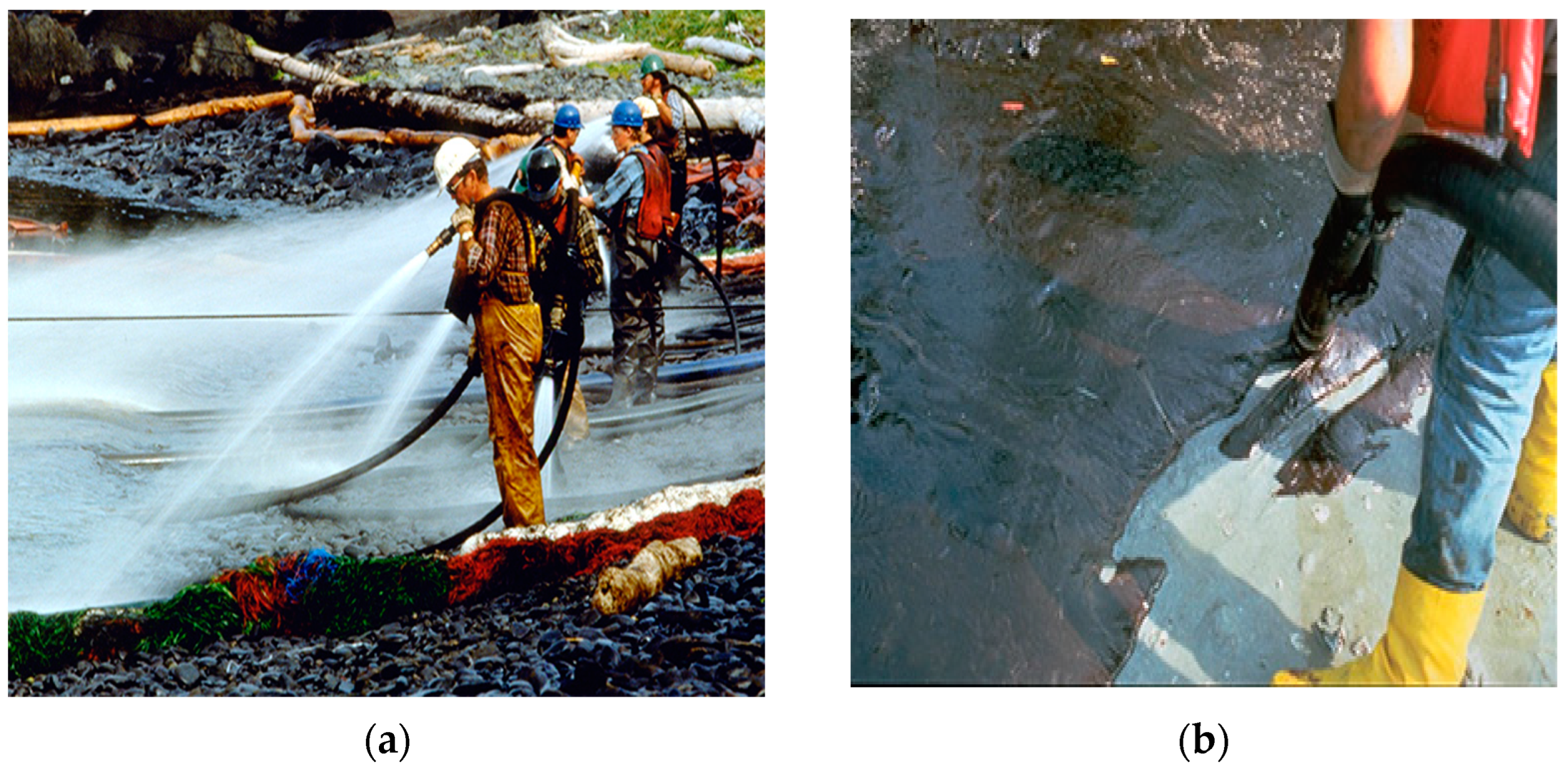
5.2.2. Current Cleanup of Oil from Onshore

In case an oil slick reaches shorelines, several cleanup techniques can be employed for oil recovery to avoid its impact on the shoreline resources [31]. Physical barriers (e.g., fences and berms) may be built onshore to prevent the transport of oil to a sensitive resource (e.g., wetland, mangroves) or to contain oil for subsequent removal [88]. One of the limitations in building such barriers is a disturbance to the shore ecosystem and may potentially impact habitats that depend on their exposure to tidal movements [18]. Additionally, this method may disrupt shoreline sediments and nearby vegetation [88]. Mechanical oil removal methods can remove a large quantity of oiled material and dig out the sediments, and oil slick from the shoreline [65]. One of the examples of mechanical removal of an oil spill is 1970 “Arrow oil spill”, where front-end loaders were used to clean the Chedabucto Bay (Nova Scotia, Canada) [89]. Other than manmade solid and bedrock beaches, mechanical cleaning can be applied to shoreline oil removal [89]. Pressure washing is one method that supplies low to high pressure pumped water through hose pipes [18] as shown in Figure 4. However, high water pressure can cause habitat destruction due to sediment loss, erosion of soft rock surfaces, etc. [31]. It is only recommended for use on rocky and gravel shorelines, in heavily oiled areas, and where oil has penetrated gravel sediments [18]. There is a concern that high pressure-hot water (27–100 °C) flushing may be detrimental, leading to the direct mortality of resident populations, forcing oil into the shoreline sediments where oil gets trapped and can wash away the beach’s fine sand or silt [18].
Besides the physical and mechanical methods for oil recovery on shorelines, several cleaning agents are available for shoreline cleanup, including surface washing agents, certain surfactants, and solvents that can soften and lift oil off the surface [86]. The surface washing agents can also be used along with the flushing method to enhance the removal efficiency [90]. The successful application of these cleaning agents to stranded oil is critical and depends on some important factors, such as (1) the chemical agent must be uniformly applied to the stranded oil; (2) molecules of a chemical agent, such as surfactants must attain concentrations at an oil-water interface that causes a reduction in the oil-water interfacial tension to promote roll-up of the oil; (3) the oil must be released from the substrate through water flushing (pressure washing or hot water flushing) [91]. In addition to these factors, soak time is very important, and it depends on ambient temperature that may influence the weathering process, such as evaporation and diffusion [86]. Generally, chemical agents are sprayed via handheld devices, motorized carts, nearshore boats, and aircraft [31].
Bioremediation is another spill response option for use on shorelines [52,92]. However, it is a slow process but can be applied to sensitive shorelines and applied after treatment with other techniques as a polishing strategy. Nutrients, such as nitrates and phosphates are applied to speed up the natural biodegradation process, also known as bio-stimulation [93]. To decide whether nutrient enrichment can be used as a remedial option, it is essential to determine the background nutrient concentration of the affected beach, including the nutrients’ level in the interstitial water [92]. If the existing nutrient levels are high relative to the optimal or threshold range, then there is no need to add more nutrients to sustain the biodegradation process [18]. In addition, if the oil penetrates into an anoxic sediments zone (anaerobic condition), then bio-stimulation has a limited chance of enhancing the process [92]. If oil-degrading microorganisms are added to aid local populations, the approach is known as bioaugmentation [93]. These inoculum microorganisms can degrade various oil constituents of crude oil [18,93]. However, it is difficult for these indigenous microorganisms to withstand the competition stress imposed by the local bacteria, making the process challenging [51]. The oil tanker Exxon Valdez spill (March 24, 1989) in Prince William Sound, Alaska, spilled approximately 104-kilo cubic meters of crude oil that spread like an oil slick over the water surface and affected the nearby beaches [94]. Due to weather conditions, oil dispersant was not possible during the incident. Therefore, the major strategies were water washing and bioremediation based on bio-simulation by adding fertilizers (N-nutrients) [88,94].
On land, including shorelines, oil can be burned along with other combustible materials, e.g., vegetation and other such substrates [95]. Additionally, in some oiled marsh situations, a ‘controlled’ burn can reduce large amounts of oil and allow vegetation recovery more quickly than might have by natural processes alone [18]. One of the most prominent examples of multiple in-situ oiled marsh burning is Louisiana over the period 2000–2019, including Time Energy (Cox Bay), Dulac (Lake Paige), and Delta Farms (Bayou Perot) [96]. This method is preferable to be applied where there is heavy oil in sites that cannot be removed with other methods or physical removal [95]. Ex-situ treatment includes an invasive method that scrapes away the contaminated sediments and affected plants or vegetation, reducing the risk of oil remobilization [97]. However, this method may disturb the shoreline ecology, slow down the recovery of existing habitat, and in the case of sediment removal, causes backshore erosion [97]. Re-construction of shorelines with similar substrates from elsewhere, usually dredged from offshore, is carried out routinely for some popular amenity beaches but is not appropriate for all shorelines [18,98]. Table 3 provides some significant examples of cleanup methods, including their advantages, limitations, and their suitability depending on shoreline types.

6. Future Perspective and Challenges in Protecting Shorelines

There are some challenges faced by oil spill cleanup along with the shoreline and coastal community as follows:

6.1. Real-Time Monitoring and Tracking of Oil Spills over Shorelines

There is a lack of real-time data and oil spill tracking/mapping under the shoreline environmental conditions. There are two approaches to address this issue (a) by implementing real-time monitoring sensors (e.g., infrared camera, drone-based optical sensors) along with GPS and digital cameras that help to collect information regarding the environmental parameters and oil characteristics [8]. High-resolution satellite data are required to observe the spatial variation for oil mapping and tracking spilled oil [65]. The obtained results will be helpful for environmental risk assessment as well. For instance, Wu et al. [99] used the Near-Infrared (NIR) satellite data to map the oil spill plume for the DWH oil spill (Gulf of Mexico) and Norilsk oil spill in 2020 (Russia). The developed technique was mainly focused on estimating the plume size and affected area while masking the noise signals in the satellite data (e.g., cloud removal and land removal). (b) The second approach is to develop laboratory and field simulation chambers for observing oil behavior, its characteristics, and wave/tidal impacts under various environmental conditions [100]. Numerous researchers have constructed mesoscale wave tank facilities to investigate the oil behavior in the water, while the studies based on shoreline simulators are still very limited [101]. There is a need to build shoreline mesocosm systems to reflect shoreline characteristics that also help to investigate oil weathering and physiochemical processes within shorelines under realistic conditions. For example, Page et al. [101] designed an experimental shoreline wave tank (“Shoreline Environmental Research Facility [SERF]” in Texas) to simulate the removal of stranded oil from a sandy beach using a washing agent and can accommodate the variations of the coastal conditions. In a recent study, Dong et al. [102] used an experimental mesoscale tank design (British Columbia) to test a novel 3-D numerical multimedia model while assessing the fate of spilled oil within a shoreline environment. It was found that the spatial distribution and transport behavior of spilled oil could be influenced by oil type and beach substrates (e.g., sandy and gravel). Thus, more such studies are required to understand the impact of shoreline characteristics on the oil spill transport mechanism.

6.2. Understanding the Impact of Microscopic and Macroscopic Aggregates

There is a need to further research the consequences of oil translocation techniques, such as washing and flushing, and the environmental impact of microscopic aggregates and macroscopic agglomerates. The overall knowledge of the in-situ toxicity levels of microscopic and macroscopic oil-sediment residues is limited [49]. Additional studies are recommended to better understand how compounds trapped in SOAs and SOMs may distribute into the surrounding medium to affect various species and how oil particle aggregates (OPAs) formed from different oil, and sediment types may affect habitats. Such studies can be a guide for implementing remediation strategies to ensure that better than harm is done to the afflicted environment.

6.3. Shoreline Based Decision Support Tools and Oil Spill Modelling Techniques

Many oil spill models can be used to predict oil transport, behavior, and fate in the marine environment, such as the multimedia environmental model [2], and commercial mathematical models (e.g., OSCAR, OSIS, GNOME) [6]. In contrast, only a few numerical models (e.g., SOCS, SINTEF, COZOIL, OILMAP) have been developed to predict the fate of oil on shorelines [48]. These models address shoreline components to inform oil trajectory and the fate of oil on shorelines. It is suggested to further improve the models by incorporating seasonal variations and environmental conditions. Moreover, an integrated GIS-based decision support system can be developed by combing predictive models that help to respond on time and optimize the control techniques while considering the baseline data, geographic information system/remote sense information, and environmental sensitivity mapping. For example, Fetissov et al. [103] developed a web-based application known as “Next-Generation Smart Response Web (NG-SRW)” to aid decision-making concerning oil spill response and assess potential oil spill impact on sensitive shorelines, biological and human-use resources for the Gulf of Finland.
Decision support tools (DSTs) play a significant role in planning an effective strategy to control oil spills, and future studies should focus on such tools while preparing OSR [58]. For instance, Multicriteria decision methods (MCDM) can be applied to evaluate and assess the impact of shoreline areas sensitive to the oil spill while selecting the best alternative with the highest score [104]. The mathematic optimization approach can be coupled with environmental sensitivity index (ESI) mapping to facilitate the OSR [58]. In addition, environmental risk assessment methods can be developed to analyze all potential risks because of oil spills and countermeasures [105].
Emergency response systems demand quick decision-making for options for cleanup methods and clarity of information so that environmental impacts can be reduced. Getting the most appropriate and effective decision is a crucial task, and discord needs to be encountered in a suitable manner. Therefore, the pros and cons of different responses need to be weighed up and compared with the advantages and disadvantages of natural cleanups, such as the process “Net Environmental Benefit Analysis (NEBA)” (a structured approach used by the stakeholders during the oil spill incident for response and to compare the environmental benefits of all the techniques to select the most effective strategy) [59]. However, there is a need for further research in this direction that helps to prioritize the allocation of resources and trade-offs associated with the feasible options for oil recovery management.

6.4. Climate Change Effects

Another outlook is to prepare the response plan while considering the climate change projection data for the specific region. As discussed earlier, spatial and seasonal variations may influence the countermeasure against the oil spill. Similarly, climate change may alter weather patterns and sea-level rise, ultimately increasing shoreline vulnerability to the oil spill. Shoreline erosions, coastal oil and gas platforms, and oil pipelines are at risk of damage or disruption at high sea levels [106]. For example, severe flooding in the San Jacinto River in 1994 ruptured over 29 pipelines at river crossings [107]. Consequently, more than 35,000 barrels of petroleum products were released into the environment, resulting in approximately 547 people living near the coastal region receiving burns and inhalation injuries [107]. In another example, the 2011 flooding on the Yellowstone River, Montana, ruptured an oil pipeline beneath this river, releasing an estimated 63,000 gallons of oil into the river and causing hazardous impacts on the surrounding recreational and private properties and water resources, including aquatic habitats [108]. Thus, oil’s behavior also varies in different environments, and the OSR strategy previously developed cannot be effective for other incidents even in the same location.

6.5. Administrative Approaches for Mitigation of Oil Spill

The governing framework for oil spill management in any country is a combination of local, national, and international authorities to effectively implement the oil spill regulations related to (1) prevention and preparedness and (2) emergency response and recovery. The oil spill incident and its location determine the responsibility of the concerned response authority. For example, the US coast guard helps to determine the potential source of oil spills from onshore facilities, vessels, and deepwater ports concerning oil spill prevention and preparedness duties [109]. Whereas the environmental protection agency (EPA) evaluates oil spills for onshore and non-transportation facilities [109]. There are some regulations enacted, for example, the Oil Pollution Act (OPA) of 1990, the first law that addressed oil pollution to waterways and coastlines in the United States [110]. International treaties play a vital role in developing standards for oil tank shipments across borders. A primary organization developed by the United Nations in this regard is the “International Maritime Organization (IMO)” which sets marine pollution and vessel safety international standards [110].
Despite efforts by the administration level to mitigate oil spills, public perception plays a primary role, and if responses are negative, it will hinder the implementation of the response strategies [111]. Hence, it is important to provide sufficient information to the local communities and the public to shape a positive perception.

7. Conclusions

This paper has presented a broad-ranging review of the environmental impact of oil spills on shorelines and coastal areas, with a principal focus on the critical aspects of shoreline type, environmental conditions, and seasonal variations. The fate of oil spills depends on the stranded oil’s transformation, and translocation processes on the shoreline are the basis for planning effective response techniques. When spilled oil is stranded on the shoreline, some oil can penetrate the lower layer due to the diverse substrate formation. The oil may relocate or become retained based on the interplay of numerous environmental factors, wave energy, tidal condition, sediment pore size, and other environmental variations. Biodegradation is one of the most dominant processes that is experienced by stranded oil. While planning an oil combat strategy, seasonal variation should be considered as oil behavior varies in elevated temperature, icy ground, and windy conditions. The first step towards cleanup is to have detailed knowledge about the morphology of the shoreline environment and wave-current along with the local environment. Effective monitoring data management, including in-situ sensors and atmospheric data using remote sensing techniques, is required to obtain spatiotemporal data. In the paper, cleanup option techniques, including preventive methods and oil recovery strategies (e.g., physical, mechanical, chemical, and biological), are discussed in depth. To enable the policymakers to assess the level of potential environmental impacts, there is a need to enhance the understanding of the dynamic behavior and complexity of spilled oil within shorelines to support the development of integrated decision-making systems.

Author Contributions

Conceptualization, Z.A. and Z.C. Writing—original draft preparation, Z.A.; Supervision and editing, Z.C.; Revision and Editing, C.A. and J.D.; All authors have read and agreed to the published version of the manuscript.

Funding

This study received no funding.

Institutional Review Board Statement

Not applicable.

Informed Consent Statement

Not applicable.

Acknowledgments

Authors would like to thank all those who directly and indirectly participated in the improvement and quality of this study.

Conflicts of Interest

The authors declare no conflict of interest.

References

  1. Zhang, B.; Matchinski, E.J.; Chen, B.; Ye, X.; Jing, L.; Lee, K. Marine oil spills-oil pollution, sources and effects (Chapter 21). In World Seas: An Environmental Evaluation Volume III: Ecological Issues and Environmental Impacts; Academic Press, Elsevier Inc.: London, UK, 2018; pp. 391–406. ISBN 9780128050521. [Google Scholar]
  2. Chughtai, R.; Asif, Z. Study fate of pollutants due to oil spill in sea water through multimedia environmental modeling. Int. J. Environ. Sci. Technol. 2021, 18, 761–770. [Google Scholar] [CrossRef]
  3. Chen, J.; Zhang, W.; Wan, Z.; Li, S.; Huang, T.; Fei, Y. Oil spills from global tankers: Status review and future governance. J. Clean. Prod. 2019, 227, 20–32. [Google Scholar] [CrossRef]
  4. Michel, J.; Fingas, M. Oil spills: Causes, consequences, prevention, and countermeasures. In Fossil Fuels: Current Status and Future Directions; World Scientific Publishing Company: Hackensack, NJ, USA, 2016; pp. 159–201. ISBN 9789814699983. [Google Scholar]
  5. Fingas, M.; Brown, C.E. A review of oil spill remote sensing. Sensors 2018, 18, 91. [Google Scholar] [CrossRef] [PubMed] [Green Version]
  6. Keramea, P.; Spanoudaki, K.; Zodiatis, G.; Gikas, G.; Sylaios, G. Oil spill modeling: A critical review on current trends, perspectives, and challenges. J. Mar. Sci. Eng. 2021, 9, 181. [Google Scholar] [CrossRef]
  7. Tarr, M.A.; Zito, P.; Overton, E.B.; Olson, G.M.; Adhikari, P.L.; Reddy, C.M. Weathering of oil spilled in the marine environment. Oceanography 2016, 29, 126–135. [Google Scholar] [CrossRef] [Green Version]
  8. Wang, Z.; An, C.; Lee, K.; Owens, E.; Chen, Z.; Boufadel, M.; Taylor, E.; Feng, Q. Factors influencing the fate of oil spilled on shorelines: A review. Environ. Chem. Lett. 2021, 19, 1611–1628. [Google Scholar] [CrossRef]
  9. Michel, J.; Fegley, S.R.; Dahlin, J.A.; Wood, C. Oil spill response-related injuries on sand beaches: When shoreline treatment extends the impacts beyond the oil. Mar. Ecol. Prog. Ser. 2017, 576, 203–218. [Google Scholar] [CrossRef] [Green Version]
  10. Bejarano, A.C.; Michel, J. Oil spills and their impacts on sand beach invertebrate communities: A literature review. Environ. Pollut. 2016, 218, 709–722. [Google Scholar] [CrossRef]
  11. Yuewen, D.; Adzigbli, L. Assessing the Impact of Oil Spills on Marine Organisms. J. Oceanogr. Mar. Res. 2018, 6, 472–479. [Google Scholar] [CrossRef]
  12. Beyer, J.; Trannum, H.C.; Bakke, T.; Hodson, P.V.; Collier, T.K. Environmental effects of the Deepwater Horizon oil spill: A review. Mar. Pollut. Bull. 2016, 110, 28–51. [Google Scholar] [CrossRef] [Green Version]
  13. NOAA How Do Oil Spills Affect Sea Turtles? Available online: https://response.restoration.noaa.gov/about/media/how-do-oil-spills-affect-sea-turtles.html (accessed on 12 October 2021).
  14. Jarvela Rosenberger, A.L.; MacDuffee, M.; Rosenberger, A.G.J.; Ross, P.S. Oil Spills and Marine Mammals in British Columbia, Canada: Development and Application of a Risk-Based Conceptual Framework. Arch. Environ. Contam. Toxicol. 2017, 73, 131–153. [Google Scholar] [CrossRef]
  15. Kahkashan, S.; Wang, X.; Ya, M.; Chen, J.; Wu, Y.; Cai, Y.; Saleem, M.; Inam, A.; Aftab, J. Evaluation of marine sediment contamination by polycyclic aromatic hydrocarbons along the Karachi coast, Pakistan, 11 years after the Tasman Spirit oil spill. Chemosphere 2019, 233, 652–659. [Google Scholar] [CrossRef] [PubMed]
  16. Kim, M.; Jung, J.H.; Ha, S.Y.; An, J.G.; Shim, W.J.; Yim, U.H. Long-Term Monitoring of PAH Contamination in Sediment and Recovery After the Hebei Spirit Oil Spill. Arch. Environ. Contam. Toxicol. 2017, 73, 93–102. [Google Scholar] [CrossRef] [PubMed]
  17. Ferguson, A.; Solo-Gabriele, H.; Mena, K. Assessment for oil spill chemicals: Current knowledge, data gaps, and uncertainties addressing human physical health risk. Mar. Pollut. Bull. 2020, 150, 110746. [Google Scholar] [CrossRef] [PubMed]
  18. Iskander, L.; Khalil, C.A.; Boufadel, M.C. Fate of Crude Oil in the Environment and Remediation of Oil Spills. STEM Fellowsh. J. 2020, 6, 69–75. [Google Scholar] [CrossRef]
  19. Solo-Gabriele, H.M.; Fiddaman, T.; Mauritzen, C.; Ainsworth, C.; Abramson, D.M.; Berenshtein, I.; Chassignet, E.P.; Chen, S.S.; Conmy, R.N.; Court, C.D.; et al. Towards integrated modeling of the long-term impacts of oil spills. Mar. Policy 2021, 131, 104554. [Google Scholar] [CrossRef]
  20. Guzman, H.M.; Kaiser, S.; Weil, E. Assessing the long-term effects of a catastrophic oil spill on subtidal coral reef communities off the Caribbean coast of Panama (1985–2017). Mar. Biodivers. 2020, 50, 28. [Google Scholar] [CrossRef]
  21. Duke, N.C. Oil spill impacts on mangroves: Recommendations for operational planning and action based on a global review. Mar. Pollut. Bull. 2016, 109, 700–715. [Google Scholar] [CrossRef]
  22. Iturbe-Espinoza, P.; Bonte, M.; Gundlach, E.; Brandt, B.W.; Braster, M.; van Spanning, R.J.M. Adaptive changes of sediment microbial communities associated with cleanup of oil spills in Nigerian mangrove forests. Mar. Pollut. Bull. 2022, 176, 113406. [Google Scholar] [CrossRef]
  23. Challenger, G.E.; Gmur, S.; Taylor, E. A review of Gulf of Mexico coastal marsh erosion studies following the 2010 Deepwater Horizon oil spill and comparison to over 4 years of shoreline loss data from Fall 2010 to Summer 2015. Mar. Pollut. Bull. 2021, 164, 111983. [Google Scholar] [CrossRef]
  24. Balogun, A.L.; Yekeen, S.T.; Pradhan, B.; Wan Yusof, K.B. Oil spill trajectory modelling and environmental vulnerability mapping using GNOME model and GIS. Environ. Pollut. 2021, 268, 115812. [Google Scholar] [CrossRef] [PubMed]
  25. Fales, R.J.; Smith, J.R. Long-term change in a high-intertidal rockweed (Pelvetiopsis californica) and community-level consequences. Mar. Biol. 2022, 169, 34. [Google Scholar] [CrossRef]
  26. Keesing, J.K.; Gartner, A.; Westera, M.; Edgar, G.J.; Myers, J.; Hardman-Mountford, N.J.; Bailey, M. Impacts and environmental risks of oil spills on marine invertebrates, algae and seagrass: A global review from an australian perspective. In Oceanography and Marine Biology; Taylor & Francis: Boca Raton, FL, USA, 2018; Volume 56, pp. 311–370. [Google Scholar]
  27. Rohal, M.; Barrera, N.; Escobar-Briones, E.; Brooks, G.; Hollander, D.; Larson, R.; Montagna, P.A.; Pryor, M.; Romero, I.C.; Schwing, P. How quickly will the offshore ecosystem recover from the 2010 Deepwater Horizon oil spill? Lessons learned from the 1979 Ixtoc-1 oil well blowout. Ecol. Indic. 2020, 117, 106593. [Google Scholar] [CrossRef]
  28. Bhattacharjee, S.; Dutta, T. Chapter 1—An Overview of Oil Pollution and Oil-Spilling Incidents; Das, P., Manna, S., Pandey, J.K., Eds.; Elsevier: Amsterdam, The Netherlands, 2022; pp. 3–15. ISBN 978-0-323-89978-9. [Google Scholar]
  29. Jézéquel, R.; Guyomarch, J.; Receveur, J.; Le Floch, S. Effect of long term natural weathering on oil composition: Study of the 41-years-old Amoco Cadiz and 20-years-old Erika oil spills. Int. Oil Spill Conf. Proc. 2021, 2021, 1141297. [Google Scholar] [CrossRef]
  30. Chang, S.E. Potential impacts of an impending oil spill. Nat. Sustain. 2021, 4, 1023–1024. [Google Scholar] [CrossRef]
  31. IPIECA-IOGP. Impacts of Oil Spills on Shorelines: Good Practice Guidelines for Incident Management and Emergency Response Personnel; IPIECA: London, UK, 2016. [Google Scholar]
  32. Wells, P.G. The iconic Torrey Canyon oil spill of 1967—Marking its legacy. Mar. Pollut. Bull. 2017, 115, 1–2. [Google Scholar] [CrossRef] [PubMed]
  33. Bernabeu, A.M.; Plaza-Morlote, M.; Rey, D.; Almeida, M.; Dias, A.; Mucha, A.P. Improving the preparedness against an oil spill: Evaluation of the influence of environmental parameters on the operability of unmanned vehicles. Mar. Pollut. Bull. 2021, 172, 112791. [Google Scholar] [CrossRef]
  34. Yang, G.G.; Bae, K.B.; Chung, W.H. Socio-ecological resilience of Oil spill: Focusing on the hebei spirit oil spill on the west coast of Korea. Int. J. Appl. Bus. Econ. Res. 2016, 14, 10793–10808. [Google Scholar]
  35. Monterrosa, C. The Aftermath of The Huntington Beach Oil Spill. Available online: https://capitalandmain.com/the-aftermath-of-the-huntington-beach-oil-spill (accessed on 12 November 2021).
  36. Suneel, V.; Rao, V.T.; Suresh, G.; Chaudhary, A.; Vethamony, P.; Ratheesh, R. Oil pollution in the Eastern Arabian Sea from invisible sources: A multi-technique approach. Mar. Pollut. Bull. 2019, 146, 683–695. [Google Scholar] [CrossRef]
  37. Sivagami, K.; Jaa Vignesh, V.; Tamizhdurai, P.; Rajasekhar, B.; Sakthipriya, N.; Nambi, I.M. Studies on short term weathering of spilled oil along Chennai coast in South India. J. Clean. Prod. 2019, 230, 1410–1420. [Google Scholar] [CrossRef]
  38. Owens, E.; Taylor, E.; Sergy, G.; Lee, K.; An, C.J.; Chen, Z. A Practical Model of the Natural Attenuation of Oil on Shorelines for Decision Support. J. Environ. Inform. Lett. 2021, 5, 48–60. [Google Scholar] [CrossRef]
  39. Zito, P.; Podgorski, D.C.; Bartges, T.; Guillemette, F.; Roebuck, J.A.; Spencer, R.G.M.; Rodgers, R.P.; Tarr, M.A. Sunlight-Induced Molecular Progression of Oil into Oxidized Oil Soluble Species, Interfacial Material, and Dissolved Organic Matter. Energy Fuels 2020, 34, 4721–4726. [Google Scholar] [CrossRef]
  40. Freeman, D.H.; Ward, C.P. Sunlight-driven dissolution is a major fate of oil at sea. Sci. Adv. 2022, 8, eabl7605. [Google Scholar] [CrossRef] [PubMed]
  41. Snyder, K.; Mladenov, N.; Richardot, W.; Dodder, N.; Nour, A.; Campbell, C.; Hoh, E. Persistence and photochemical transformation of water soluble constituents from industrial crude oil and natural seep oil in seawater. Mar. Pollut. Bull. 2021, 165, 112049. [Google Scholar] [CrossRef] [PubMed]
  42. Ward, C.P.; Overton, E.B. How the 2010 Deepwater Horizon spill reshaped our understanding of crude oil photochemical weathering at sea: A past, present, and future perspective. Environ. Sci. Process. Impacts 2020, 22, 1125–1138. [Google Scholar] [CrossRef]
  43. Boufadel, M.; Geng, X.; An, C.; Owens, E.; Chen, Z.; Lee, K.; Taylor, E.; Prince, R.C. A Review on the Factors Affecting the Deposition, Retention, and Biodegradation of Oil Stranded on Beaches and Guidelines for Designing Laboratory Experiments. Curr. Pollut. Rep. 2019, 5, 407–423. [Google Scholar] [CrossRef]
  44. Gao, Y.; Zhao, X.; Ju, Z.; Yu, Y.; Qi, Z.; Xiong, D. Effects of the suspended sediment concentration and oil type on the formation of sunken and suspended oils in the Bohai Sea. Environ. Sci. Process. Impacts 2018, 20, 1404–1413. [Google Scholar] [CrossRef]
  45. Clement, T. Spills, Sediment, and Shoreline Contamination. Eos 2018. Available online: https://eos.org/editors-vox/spills-sediment-and-shoreline-contamination (accessed on 28 January 2022). [CrossRef]
  46. Renegar, D.A.; Schuler, P.; Turner, N.; Dodge, R.; Knap, A.; Bera, G.; Jézéquel, R.; Benggio, B. Tropical Oil Pollution Investigations in Coastal Systems [TROPICS]: A 32-year Review of Response and Recovery. Int. Oil Spill Conf. Proc. 2021, 2021, 688277. [Google Scholar] [CrossRef]
  47. Michel, J.; Bambach, P. A Response Guide for Sunken Oil Mats (SOMs): Formation, Behavior, Detection, and Recovery. J. Mar. Sci. Eng. 2022, 10, 368. [Google Scholar] [CrossRef]
  48. Taylor, E.; Owens, E.H.; Lee, K.; An, C.J.; Chen, Z. A Review of Numerical Models for Oil Penetration, Retention, and Attenuation on Shorelines. J. Environ. Inform. Lett. 2021, 5, 27–38. [Google Scholar] [CrossRef]
  49. Gustitus, S.A.; Clement, T.P. Formation, Fate, and Impacts of Microscopic and Macroscopic Oil-Sediment Residues in Nearshore Marine Environments: A Critical Review. Rev. Geophys. 2017, 55, 1130–1157. [Google Scholar] [CrossRef]
  50. Etkin, D.S. Estimation of shoreline response cost factors. In Proceedings of the 2005 International Oil Spill Conference; IOSC: Vancouver, BC, Canada, 2005; pp. 1243–1253. [Google Scholar]
  51. Geng, X.; An, C.; Lee, K.; Boufadel, M.C. Modeling oil biodegradation and bioremediation within beaches. Curr. Opin. Chem. Eng. 2022, 35, 100751. [Google Scholar] [CrossRef]
  52. Ellis, M.; Altshuler, I.; Schreiber, L.; Chen, Y.-J.; Okshevsky, M.; Lee, K.; Greer, C.W.; Whyte, L.G. Hydrocarbon biodegradation potential of microbial communities from high Arctic beaches in Canada’s Northwest Passage. Mar. Pollut. Bull. 2022, 174, 113288. [Google Scholar] [CrossRef] [PubMed]
  53. Al-Hawash, A.B.; Dragh, M.A.; Li, S.; Alhujaily, A.; Abbood, H.A.; Zhang, X.; Ma, F. Principles of microbial degradation of petroleum hydrocarbons in the environment. Egypt. J. Aquat. Res. 2018, 44, 71–76. [Google Scholar] [CrossRef]
  54. Geng, X.; Khalil, C.A.; Prince, R.C.; Lee, K.; An, C.; Boufadel, M.C. Hypersaline Pore Water in Gulf of Mexico Beaches Prevented Efficient Biodegradation of Deepwater Horizon Beached Oil. Environ. Sci. Technol. 2021, 55, 13792–13801. [Google Scholar] [CrossRef] [PubMed]
  55. Zakaria, N.N.; Convey, P.; Gomez-Fuentes, C.; Zulkharnain, A.; Sabri, S.; Shaharuddin, N.A.; Ahmad, S.A. Oil bioremediation in the marine environment of antarctica: A review and bibliometric keyword cluster analysis. Microorganisms 2021, 9, 419. [Google Scholar] [CrossRef]
  56. Zahri, K.N.M.; Zulkharnain, A.; Gomez-Fuentes, C.; Sabri, S.; Khalil, K.A.; Convey, P.; Ahmad, S.A. The use of response surface methodology as a statistical tool for the optimisation of waste and pure canola oil biodegradation by antarctic soil bacteria. Life 2021, 11, 456. [Google Scholar] [CrossRef]
  57. Niu, H.; Li, P.; Yang, R.; Wu, Y.; Lee, K. Effects of chemical dispersant and seasonal conditions on the fate of spilled oil—modelling of a hypothetical spill near Saint John, NB. Water Qual. Res. J. Canada 2016, 51, 233–245. [Google Scholar] [CrossRef]
  58. Yang, Z.; Chen, Z.; Lee, K.; Owens, E.; Boufadel, M.C.; An, C.; Taylor, E. Decision support tools for oil spill response (OSR-DSTs): Approaches, challenges, and future research perspectives. Mar. Pollut. Bull. 2021, 167, 112313. [Google Scholar] [CrossRef]
  59. Wenning, R.J.; Robinson, H.; Bock, M.; Rempel-Hester, M.A.; Gardiner, W. Current practices and knowledge supporting oil spill risk assessment in the Arctic. Mar. Environ. Res. 2018, 141, 289–304. [Google Scholar] [CrossRef] [PubMed]
  60. Nordam, T.; Dunnebier, D.A.E.; Beegle-Krause, C.; Reed, M.; Slagstad, D. Impact of climate change and seasonal trends on the fate of Arctic oil spills. Ambio 2017, 46, 442–452. [Google Scholar] [CrossRef] [PubMed] [Green Version]
  61. Cariglia, N.; Challenger, G.; Beer, N. The Use and Misuse of SCAT in Spill Response. Int. Oil Spill Conf. Proc. 2017, 2017, 2642–2659. [Google Scholar] [CrossRef]
  62. Owens, E.; Santner, R. Integration of a shoreline response program (SRP) and shoreline assessment surveys into an Incident Management System for oil spill response. J. Environ. Manag. 2021, 279, 111637. [Google Scholar] [CrossRef] [PubMed]
  63. Bayramov, E.; Kada, M.; Buchroithner, M. Monitoring oil spill hotspots, contamination probability modelling and assessment of coastal impacts in the Caspian Sea using SENTINEL-1, LANDSAT-8, RADARSAT, ENVISAT and ERS satellite sensors. J. Oper. Oceanogr. 2018, 11, 27–43. [Google Scholar] [CrossRef]
  64. Fingas, M.; Brown, C.E. An Update on Oil Spill Remote Sensing. In Advances in Environmental Research; Nova Science Publishers Inc.: New York, NY, USA, 2021; Volume 80, pp. 95–137. ISBN 9781536194340. [Google Scholar]
  65. Pradhan, B.; Das, M.; Pradhan, C. Marine oil spills: Implications on response plan. EnvironmentAsia 2021, 14, 13–22. [Google Scholar] [CrossRef]
  66. Haule, K.; Toczek, H.; Borzycka, K.; Darecki, M. Influence of dispersed oil on the remote sensing reflectance—field experiment in the baltic sea. Sensors 2021, 21, 5733. [Google Scholar] [CrossRef]
  67. Prasad, S.; Balakrishnan Nair, T.M. Quantification of oil lost from tanker vessel using space borne radar datasets—Case study of Haldia port oil spill, July 2018. Int. Oil Spill Conf. Proc. 2021, 2021, 686884. [Google Scholar] [CrossRef]
  68. Yekeen, S.T.; Balogun, A.L. Advances in remote sensing technology, machine learning and deep learning for marine oil spill detection, prediction and vulnerability assessment. Remote Sens. 2020, 12, 1–31. [Google Scholar]
  69. Liu, B.; Li, Y.; Zhang, Q.; Han, L. Assessing Sensitivity of Hyperspectral Sensor to Detect Oils with Sea Ice. J. Spectrosc. 2016, 2016, 6584314. [Google Scholar] [CrossRef] [Green Version]
  70. Leifer, I.; Lehr, W.J.; Simecek-Beatty, D.; Bradley, E.; Clark, R.; Dennison, P.; Hu, Y.; Matheson, S.; Jones, C.E.; Holt, B.; et al. State of the art satellite and airborne marine oil spill remote sensing: Application to the BP Deepwater Horizon oil spill. Remote Sens. Environ. 2012, 124, 185–209. [Google Scholar] [CrossRef] [Green Version]
  71. Liang, Z.; Bin, Z.; Zhengchao, C.; Lanfen, Z.; Qingxi, T. The application of hyperspectral remote sensing to coast environment investigation. Acta Oceanol. Sin. 2009, 28, 1–13. [Google Scholar]
  72. Suo, Z.; Lu, Y.; Liu, J.; Ding, J.; Yin, D.; Xu, F.; Jiao, J. Ultraviolet remote sensing of marine oil spills: A new approach of Haiyang-1C satellite. Opt. Express 2021, 29, 13486–13495. [Google Scholar] [CrossRef] [PubMed]
  73. Fingas, M. The challenges of remotely measuring oil slick thickness. Remote Sens. 2018, 10, 319. [Google Scholar] [CrossRef] [Green Version]
  74. Garcia-Pineda, O.; Staples, G.; Jones, C.E.; Hu, C.; Holt, B.; Kourafalou, V.; Graettinger, G.; DiPinto, L.; Ramirez, E.; Streett, D.; et al. Classification of oil spill by thicknesses using multiple remote sensors. Remote Sens. Environ. 2020, 236, 111421. [Google Scholar] [CrossRef]
  75. Valdor, P.F.; Gómez, A.G.; Velarde, V.; Puente, A. Can a GIS toolbox assess the environmental risk of oil spills? Implementation for oil facilities in harbors. J. Environ. Manag. 2016, 170, 105–115. [Google Scholar] [CrossRef]
  76. Ivanov, A.Y.; Zatyagalova, V.V. A GIS approach to mapping oil spills in a marine environment. Int. J. Remote Sens. 2008, 29, 6297–6313. [Google Scholar] [CrossRef]
  77. El-Magd, I.A.; Zakzouk, M.; Ali, E.M.; Abdulaziz, A.M. An open source approach for near-real time mapping of oil spills along the mediterranean coast of Egypt. Remote Sens. 2021, 13, 2733. [Google Scholar] [CrossRef]
  78. Jones, C.E.; Holt, B. Experimental L-band airborne SAR for oil spill response at sea and in coastal waters. Sensors 2018, 18, 641. [Google Scholar] [CrossRef] [Green Version]
  79. Shu, S.; Meng, J.; Zhang, X.; Guo, J.; Liu, G. Experimental study of C-band microwave scattering characteristics during the emulsification process of oil spills. Acta Oceanol. Sin. 2020, 39, 135–145. [Google Scholar] [CrossRef]
  80. Babu, A.; Kumar, S.; Agrawal, S. Polarimetric Calibration of L-Band UAVSAR Data. J. Indian Soc. Remote Sens. 2021, 49, 541–549. [Google Scholar] [CrossRef]
  81. Alpers, W.; Holt, B.; Zeng, K. Oil spill detection by imaging radars: Challenges and pitfalls. Remote Sens. Environ. 2017, 201, 133–147. [Google Scholar] [CrossRef]
  82. Grubesic, T.; Wei, R.; Nelson, J. Protecting Sensitive Coastal Areas with Exclusion Booms during Oil Spill Events. Environ. Model. Assess. 2019, 24, 479–494. [Google Scholar] [CrossRef]
  83. Dhaka, A.; Chattopadhyay, P. A review on physical remediation techniques for treatment of marine oil spills. J. Environ. Manage. 2021, 288, 112428. [Google Scholar] [CrossRef] [PubMed]
  84. Etkin, D.S.; Nedwed, T.J. Effectiveness of mechanical recovery for large offshore oil spills. Mar. Pollut. Bull. 2021, 163, 111848. [Google Scholar] [CrossRef]
  85. White, H.K.; Karras, S. The Use of Dispersants in Marine Oil Spill Response. Int. Oil Spill Conf. Proc. 2021, 2021, 689431. [Google Scholar] [CrossRef]
  86. Grote, M.; van Bernem, C.; Böhme, B.; Callies, U.; Calvez, I.; Christie, B.; Colcomb, K.; Damian, H.P.; Farke, H.; Gräbsch, C.; et al. The potential for dispersant use as a maritime oil spill response measure in German waters. Mar. Pollut. Bull. 2018, 129, 623–632. [Google Scholar] [CrossRef]
  87. Ye, X.D.; Zhu, Z.W.; Merlin, F.; Yang, M.; Chen, B.; Lee, K.; Zhang, B.Y. Ecological Impact Analysis of Dispersants and Dispersed Oil: An Overview. JEIL 2021, 5, 120–133. [Google Scholar] [CrossRef]
  88. Lim, M.W.; Lau, E.V.; Poh, P.E. A comprehensive guide of remediation technologies for oil contaminated soil—Present works and future directions. Mar. Pollut. Bull. 2016, 109, 14–45. [Google Scholar] [CrossRef]
  89. Feng, Q.; An, C.J.; Cao, Y.; Chen, Z.; Owens, E.; Taylor, E.; Wang, Z.; Saad, E.A. An Analysis of Selected Oil Spill Case Studies on the Shorelines of Canada. J. Environ. Inform. Lett. 2021, 5, 39–47. [Google Scholar] [CrossRef]
  90. Bi, H.; An, C.; Owens, E.; Lee, K.; Chen, Z.; Mulligan, C.; Taylor, E.; Boufadel, M. A framework for the evaluation and selection of shoreline surface washing agents in oil spill response. J. Environ. Manag. 2021, 287, 112346. [Google Scholar] [CrossRef] [PubMed]
  91. NOAA. Clean Up Spilled Oil at all Costs? Not Always. Available online: https://blog.response.restoration.noaa.gov/clean-spilled-oil-all-costs-not-always (accessed on 9 November 2021).
  92. Sharma, R.; Singh, N.S.; Dhingra, N.; Parween, T. Bioremediation of Oil-Spills from Shoreline Environment. In Modern Age Waste Water Problems; Springer: Cham, Switzerland, 2020; pp. 275–291. [Google Scholar]
  93. Popoola, L.T.; Yusuff, A.S.; Adeyi, A.A.; Omotara, O.O. Bioaugmentation and biostimulation of crude oil contaminated soil: Process parameters influence. S. Afr. J. Chem. Eng. 2022, 39, 12–18. [Google Scholar] [CrossRef]
  94. Baniasadi, M.; Mousavi, S.M. A comprehensive review on the bioremediation of oil spills. In Microbial Action on Hydrocarbons; Springer: Singapore, 2019; pp. 223–254. ISBN 9789811318405. [Google Scholar]
  95. Fingas, M. In Situ Burning: An Update. In Oil Spill Science and Technology: Second Edition; Gulf Professional Publishing: Houston, TX, USA, 2017; pp. 483–676. ISBN 9781856179430. [Google Scholar]
  96. Michel, J.; Zengel, S. Good Practices for In-situ Burning of Marshes Based on Two Decades of Responses in Louisiana. Int. Oil Spill Conf. Proc. 2021, 2021, 687591. [Google Scholar] [CrossRef]
  97. Taneez, M.; Hurel, C.; Mady, F.; Francour, P. Capping of marine sediments with valuable industrial by-products: Evaluation of inorganic pollutants immobilization. Environ. Pollut. 2018, 239, 714–721. [Google Scholar] [CrossRef]
  98. Kurbangaleeva, M.K. Improvement of Emergency Oil Spill Management Technology. IOP Conf. Ser. Earth Environ. Sci. 2022, 988, 022008. [Google Scholar] [CrossRef]
  99. Wu, C.; Chen, Z.; An, C.; Lee, K.; Wang, B.; Boufadel, M.C.; Asif, Z. Examining an Oil Spill Plume Mapping Method based on Satellite NIR Data. J. Environ. Inform. Lett. 2021, 5, 17–26. [Google Scholar] [CrossRef]
  100. Yu, Y.; Qi, Z.; Fu, S.; Yu, X.; Li, W.; Xiong, D. Effects of wave conditions and particle size on the release of oil from oil-contaminated sediments in a wave tank. J. Mar. Sci. Eng. 2019, 7, 256. [Google Scholar] [CrossRef] [Green Version]
  101. Page, C.A.; Fuller, C.; Autenrieth, R.L.; Bonner, J.S.; Louchouarn, P.; Tissot, P.; McDonald, T. Shoreline cleaner use in a sandy beach environment. In Proceedings of the 2005 International Oil Spill Conference; IOSC: Vancouver, BC, Canada, 2005; pp. 7696–7699. [Google Scholar]
  102. Dong, J.; An, C.; Chen, Z.; Owens, E.; Boufadel, M.; Taylor, E.; Lee, K. A 3D Numerical Environmental Modeling Approach for Assessing Transport of Spilled Oil in Porous Beach Conditions under a Meso-Scale Tank Design. Int. J. Environ. Ecol. Eng. 2021, 177, 262–269. [Google Scholar]
  103. Fetissov, M.; Aps, R.; Goerlandt, F.; Jänes, H.; Kotta, J.; Kujala, P.; Szava-Kovats, R. Next-generation smart response web (Ng-srw): An operational spatial decision support system for maritime oil spill emergency response in the gulf of Finland (baltic sea). Sustainability 2021, 13, 6585. [Google Scholar] [CrossRef]
  104. Zafirakou, A.; Themeli, S.; Tsami, E.; Aretoulis, G. Multi-criteria analysis of different approaches to protect the marine and coastal environment from oil spills. J. Mar. Sci. Eng. 2018, 6, 125. [Google Scholar] [CrossRef] [Green Version]
  105. Stephansen, C.; Bjørgesæter, A.; Brude, O.W.; Brönner, U.; Kjeilen-Eilertsen, G.; Libre, J.-M.; Rogstad, T.W.; Nygaard, C.F.; Sørnes, T.; Skeie, G.M.; et al. ERA Acute—A Multi-Compartment Quantitative Risk Assessment for Oil Spills. Int. Oil Spill Conf. Proc. 2017, 2017, 2017432. [Google Scholar] [CrossRef]
  106. Katopodis, T.; Sfetsos, A. A review of climate change impacts to oil sector critical services and suggested recommendations for industry uptake. Infrastructures 2019, 4, 74. [Google Scholar] [CrossRef] [Green Version]
  107. Blaney, T.M. Using a Distributed Hydrologic Model and Unsteady Hydraulic Model on the West Fork San Jacinto River; Rice University: Ann Arbor, MI, USA, 2020. [Google Scholar]
  108. Emerson, M.R.; Hall, D.M.; Gilbertz, S.J. Pipeline pipedreams: Oil spills, pipeline accidents, and the local truths embedding fossil fuels in the Yellowstone River Valley, United States. Energy Res. Soc. Sci. 2021, 72, 101859. [Google Scholar] [CrossRef]
  109. Reiling, K. The Emergence of Maritime Governance in the Post-War World; Palgrave Macmillan: London, UK, 2019; pp. 37–65. [Google Scholar]
  110. Ramseur, J.L. Oil spills in U.S. Coastal Waters: Background, Governance, and Issues for Congress. Congressional Research Service Report. 2018. Available online: https://www.arlis.org/docs/vol1/79721884.pdf (accessed on 28 May 2022).
  111. Chun, J.; Oh, J.H.; Kim, C.K. Oil spill response policies to bridge the perception gap between the government and the public: A social big data analysis. J. Mar. Sci. Eng. 2020, 8, 335. [Google Scholar] [CrossRef]
Figure 1. Examples of different forms of oil contamination along with various beaches (a) Oil sheet along with tar balls at gravel beach, south beach, Lebanon, (b) Gooey mass of spilled oil at sandy beach (c) Lebanon rocky beach cleaning of oil spill by workers. (Public domain).
Jmse 10 00762 g001
Figure 2. Example of the oil fate on shorelines.
Jmse 10 00762 g002
Figure 3. Depth of oil penetration by shoreline sediment type based on various oiling degrees considering Exxon Valdez Spill database.
Jmse 10 00762 g003
Figure 4. Cleaning oiled rocks with (a) high-pressure hoses after the 1989 Exxon Valdez oil spill in Prince William Sound, Alaska; (b) Heavy oil vacuumed from a sandy beach following the 1993 oil spill, Tampa Bay (Public domain: credit to NOAA’s Office of Response and Restoration).
Jmse 10 00762 g004
Table 1. Examples from past major oil spill events and their impact on shorelines.
Oil Spill IncidentOil SpilledImpact on ShorelinesReferences
Ixtoc 1 Oil Well (1979, the Bay of Campeche of the Gulf of Mexico)140 million gallons (529,961 m3) of the total oil spilledImpact on prominent nesting sites for Kemp’s Ridley Sea turtles on Mexican coasts.[27]
Castillo de Bellver (1983, en route to Spain from the Persian Gulf)79 million gallons (299,049 m3) of total crude oil spilledAffected thousands of gannets (sea birds) gathered on a nearby island for their breeding season[28]
Amoco Cadiz (1978, coast of Brittany, France)Total of 64.9 million gallons (245,675 m3) of light crude oilIt affected approximately 76 beaches along 80 miles in length.[29]
Exxon Valdez Oil Spill (1989, Prince William Sound’s Bligh Reef in Alaska)10.9 million gallons (41,261 m3) reached beachesKilled over 250,000 seabirds, almost 2800 sea otters, and 300 harbor seals, among others.[30]
Coatzacoalcos River, Mexico (2005, broken PEMEX oil pipeline)Total crude oil spilled is 7000 gallons (26.49 m3)Red mangroves are badly affected, along with birds and animals.[31]
Macondo incident (2010, Deep Horizon Oil Spill in the Gulf of Mexico)210 million gallons (794,924 m3) of the total oil spilledOiling of fringing saltmarsh in some areas of Barataria Bay, Louisiana; In 2013, in Louisiana, 6229 m3 of spilled oil was removed from the beaches. Oil cleanup crews worked four days a week along the 89 km of Louisiana shoreline. Oil continued to be found as far from the Macondo site as the waters of the Florida Panhandle and Tampa Bay.[23]
Torrey Canyon oil spill (1967, Seven stones reef, Islets of Scilly, England, UK)31.5 million gallons (119,241 m3) of total crude oil spilledDeaths of many seabirds, threatening the livelihoods of local people, polluted beaches and harbors in the Channel Islands and Brittany.[32]
The Prestige oil spill (2002, Northern Spain)20.3 million gallons (76,844 m3) of heavy fuel oilAffected 1900 km of shoreline, the fishing and tourism sectors mostly affected; heavily contaminated rocky shoreline.[33]
Hebei Spirit oil spill (2007, Republic of South Korea)2.9 million gallons spilled (10,977 m3)Affected seabirds, sandy beaches, rocky shores, and benthic species.[34]
Huntington Beach oil spill (October 2021, California)Estimated to be at least 25,000 gallons (94.6 m3) and no more than 132,000 gallons (499.7 m3) due to a pipeline leakAn oil slick off the California beach killed many fish and contaminated wetlands.[35]
Table 2. Comparison of various remote sensors for oil spill detection.
FactorsVisibleInfraredUVRadarMicrowave
Radiometer
Laser Fluorosensors
References[65][5][72][64][73][68]
Spatial ResolutionHighThe hot and cold layer lies between 50 and 150 µmHighHighLowHigh
Wavelength350−700 nmThermal: 8−14 µm
Mid band: 3−5 µm
Near: 1−3 µm
250−350 nm1−30 cm2−8 mm308−355 nm
OutputSheen of oilThick oil appears hot, intermediate thicknesses of oil appear coolMap sheens of oil, the relative thicknessOil slick may be observed as a “dark” seaThickness of oilDiscriminate between oiled and unoiled seaweeds and detect oil on different types of shorelines, snow, and ice
False detectionSun glitter, darker shoreline, biogenic material (e.g., seaweeds)Seaweed, shorelines, sediments, organic matterWind slick, sun glint, biogenic materialMany interferences
(e.g., freshwater slicks, wind slicks (calms), shallow seaweed, glacial flour, biogenic oils
Biogenic materialsNo interference and can detect oil on all kinds of backgrounds
Oil classificationNoNoNoNoNoYes
Day and night operationNoYesNoYesYesYes
Weather requirementRequire clear weatherNot good in clouds and heavy fogRequire clear weatherOperated under all-weather type (dependent on wind speed)Operated under all-weather type except for heavy rainNot good in clouds and fog
Dedicated aircraftsNoNoNoYesYesYes
Table 3. Pros and Cons of oil cleanup techniques for shorelines.
Cleanup MethodsExamplesAdvantagesLimitationsShoreline TypeReferences
Physical/Mechanical methodPressure washer (low and high) and hot flushing waterEffective removal of the majority of the oil spill by using sea water and wash oil towards a collection areaOil may penetrate deeper into the sediment; threaten plants and other habitatsBedrock, ice, solid manmade[31]
Vacuum/pumpingRemoves/sucked pooled oil from various surfaces (e.g., marsh sediment)Energy is required for power, may disrupt the environmentAll[98]
Chemical methodDispersantWhen dispersing, the oil will cause less impact than slicks that strand onshoreLow effectiveness with heavy, weathered, or emulsified oilsManmade, beaches,
rocky, ice
[85]
Surface washing agentTo increase oil removal, often at lower temperature and pressure; to flush oil trapped in inaccessible areasApplied on land only where wash waters can be collected for treatment; use “lift and float” products on shorelines to allow oil recovery rather than allowing dispersion into the water bodyManmade, beaches,
rocky, ice
[90]
SolidifiersIt alters the viscosity of oil and helps in its collection and recoveryVery labor-intensiveAll except cobbles and boulders[86]
Biological methodBio-stimulationAccelerate biodegradationSome nutrients are expensive to apply in the field, time-consumingAll[93]
Bio-augmentationAccelerate biodegradationNot effective for shorelines or beaches if they already have hydrocarbons degradersAll[51]
In-situControlled burningQuick removal of a large amount of heavy oilAir emissionsBeaches, wetlands[96]
Dry or wet mixingDry: to increase the exposure of subsurface to air and tides to accelerate natural weathering
Wet: to recover surface oil by physically agitating intertidal sediments in shallow water
Labour required and time-consuming procedureBeaches, flats[18]
Ex-situ treatmentScrape away the sediments or contaminated patches using manual and mechanical removal, vegetation cuttingMost of the oil removed to prevent oil remobilizationVery costly, disturbance of the environmentAll[18]
Publisher’s Note: MDPI stays neutral with regard to jurisdictional claims in published maps and institutional affiliations.

