
Field Investigation on the Coastal Erosion and Progradation Evolution of the Binzhou Shelly Chenier in China: Comparisons between Normal and Typhoon Hydrodynamics


 ,
, 
Abstract
:1. Introduction
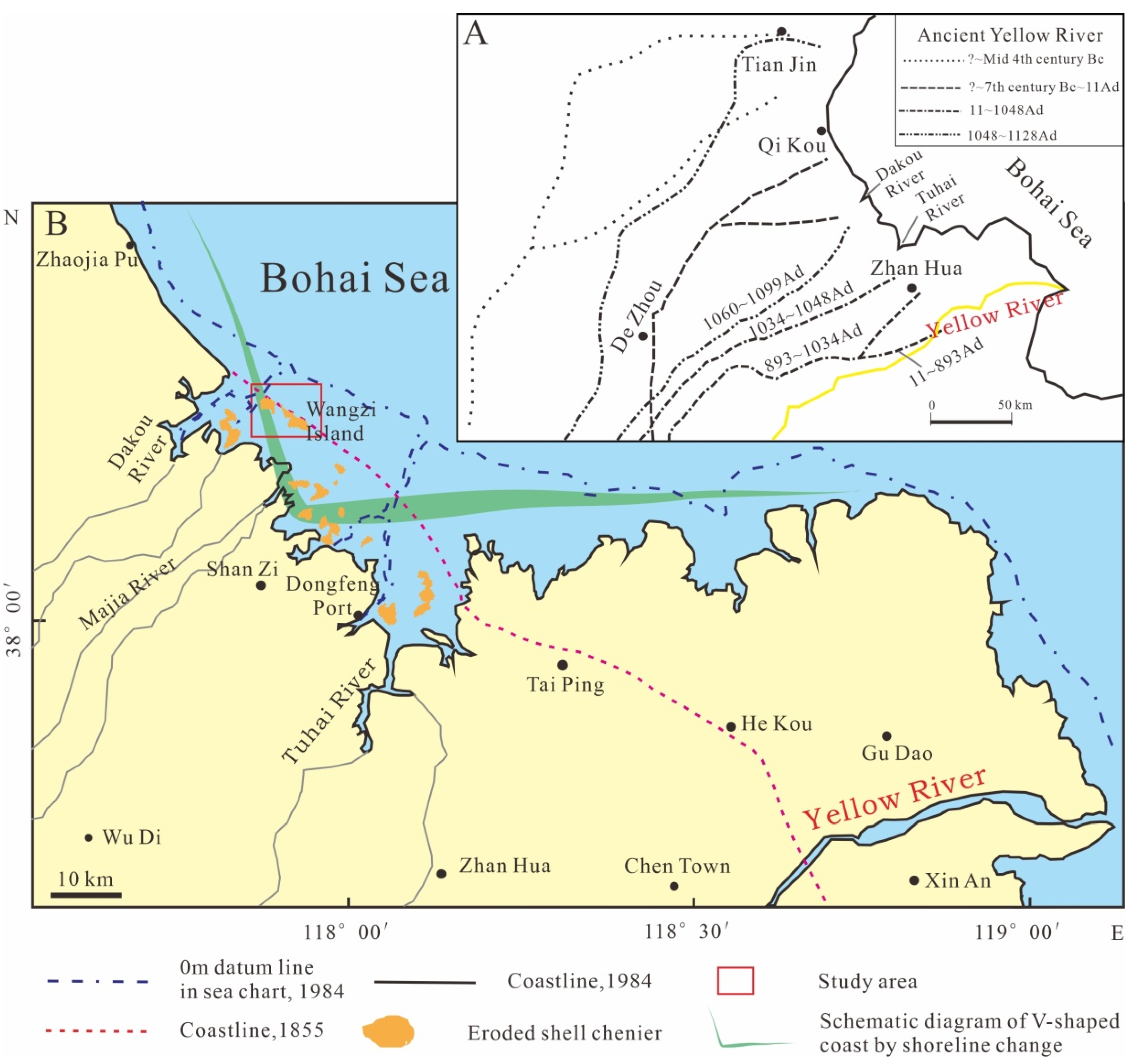
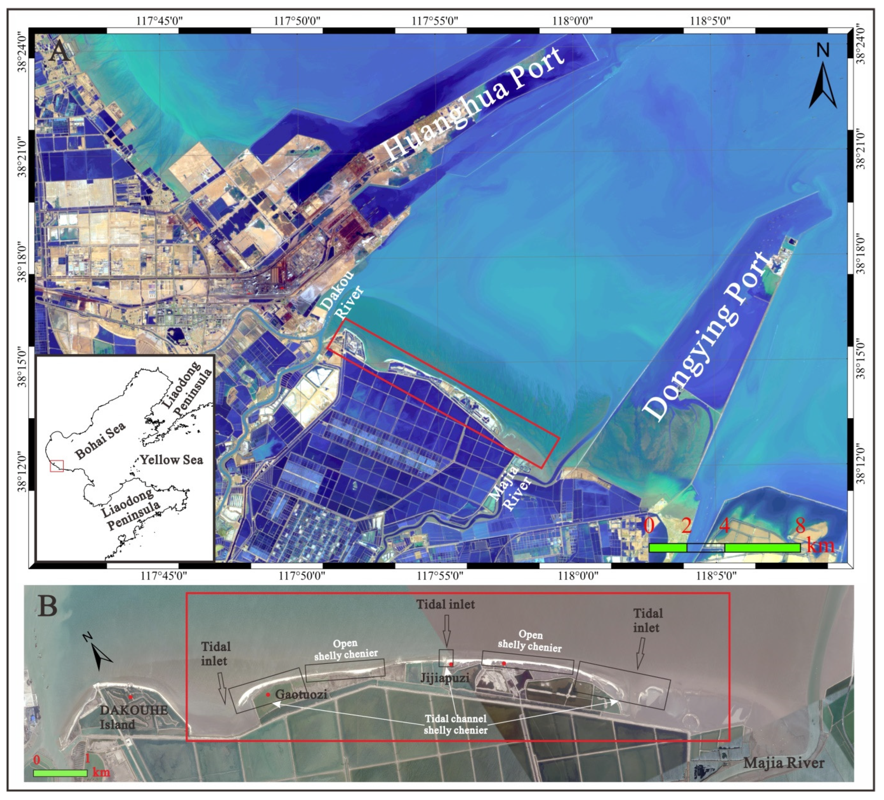
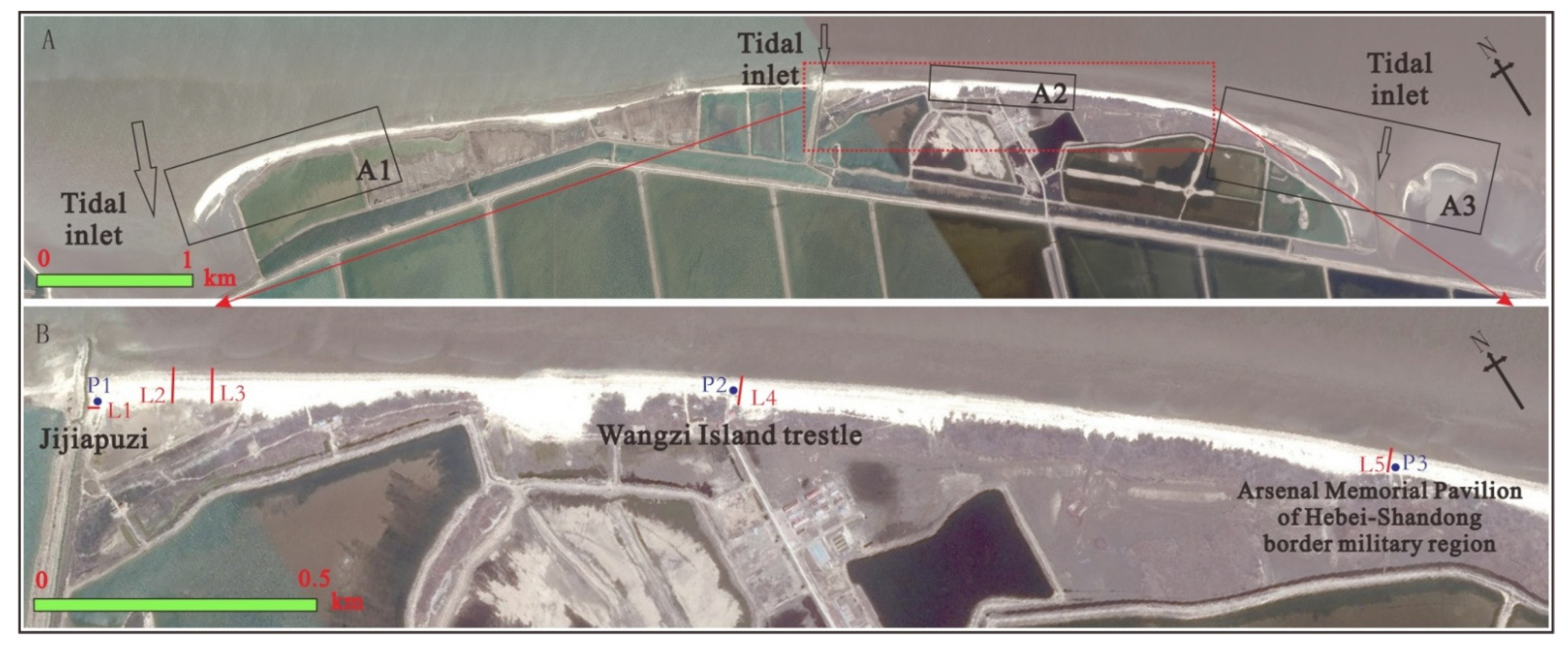
2. Study Area
3. Research Methods
4. Results
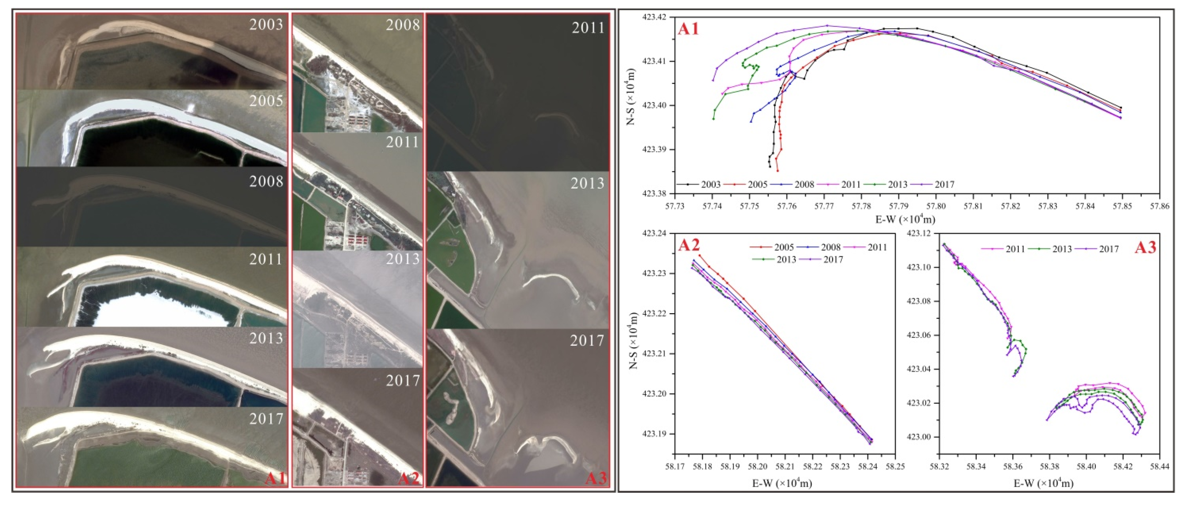
4.1. Remote Sensing Interpretation
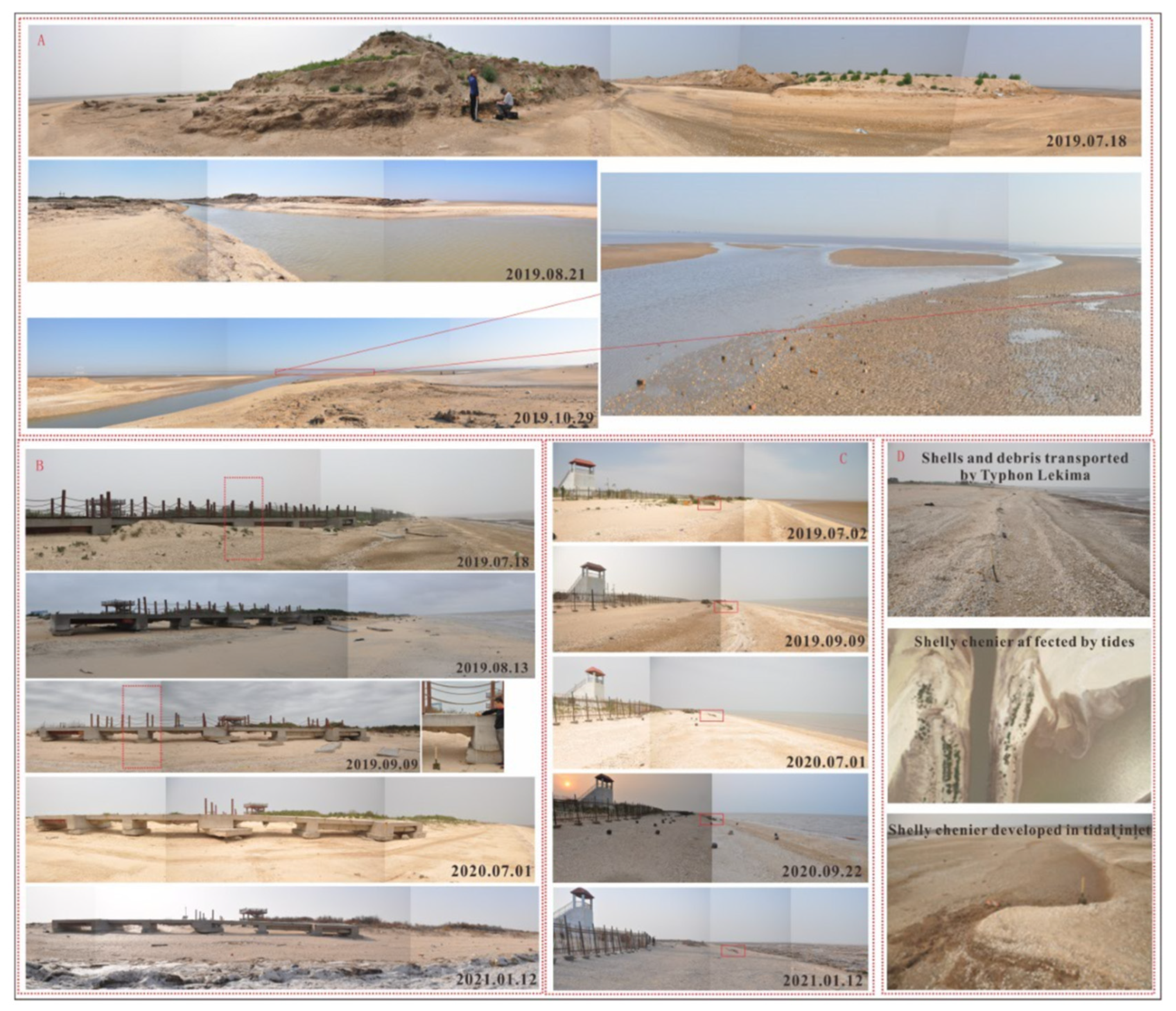
4.2. Typical Geomorphic Survey
4.3. Beach Profile Elevation Survey
5. Analysis
6. Conclusions
Author Contributions
Funding
Institutional Review Board Statement
Informed Consent Statement
Data Availability Statement
Acknowledgments
Conflicts of Interest
References
- Russell, E.J.; Howe, H.V. Cheniers of southwestern Louisiana. Geogr. Rev. 1935, 25, 449–461. [Google Scholar] [CrossRef]
- Otvos, E.G.; Price, W.A. Problems of Chenier genesis and terminology: An overview. Mar. Geol. 1979, 31, 251–263. [Google Scholar] [CrossRef]
- Otvos, E.G. Cheniers. In Encyclopaedia of Coastal Science; Finkl, C., Makowski, C., Eds.; Springer: Berlin, Germany, 2018; pp. 1–17. [Google Scholar]
- Scheffers, A.; Engel, M.; Scheffers, S.; Squire, P.; Kelletat, D. Beach ridge systems-archives for Holocene coastal events? Prog. Phys. Geogr. 2012, 36, 5–37. [Google Scholar] [CrossRef]
- Tamura, T. Beach ridges and prograded beach deposits as palaeoenvironment records. Earth Sci. Rev. 2012, 114, 279–297. [Google Scholar] [CrossRef]
- Nardin, W.; Fagherazzi, S. The role of waves, shelf slope, and sediment characteristics on the development of erosional chenier plains. Geophys. Res. Lett. 2018, 45, 8435–8444. [Google Scholar] [CrossRef]
- Augustinus, P.G.E.F. Cheniers and chenier plains: A general introduction. Mar. Geol. 1989, 90, 219–229. [Google Scholar] [CrossRef]
- Saito, Y.; Wei, H.L.; Zhou, Y.; Nishimura, A.; Sato, Y.; Yokota, S. Delta progradation and chenier formation in the Huanghe (Yellow River) Delta, China. J. Asian Earth Sci. 2000, 18, 489–497. [Google Scholar] [CrossRef]
- Zhao, X.T. Cheniers in Chia: An overview. Mar. Geol. 1989, 90, 311–320. [Google Scholar]
- Wang, Y. The shell coast ridge and the old coastlines of the west coast of the Bohai Bay. Acta Sci. Natl. Univ. Nankinesis 1964, 8, 424–442. [Google Scholar]
- Chen, Y.S.; Li, J.F.; Yang, P.; Wang, F.; Tian, L.Z. AMS 14C ages of marine shells and the residence time effect on the north coastal of Bohai Bay. North China Geol. 2021, 44, 21–27. [Google Scholar]
- Delaune, R.; Jugsujinda, A.; Gambrell, R.; Miao, S. Metal concentrations and trace metal Al and Fe ratios in soil of the Chenier Plain, Southwest Louisiana coastal zone. J. Environ. Sci. Health A 2008, 43, 300–312. [Google Scholar] [CrossRef] [PubMed]
- Draut, A.E.; Kineke, G.C.; Huh, O.K.; Grymes, J.M.; Westphal, K.A.; Moeller, C.C. Coastal mudflat accretion under energetic conditions, Louisiana chenier-plain coast, USA. Mar. Geol. 2008, 214, 27–47. [Google Scholar] [CrossRef]
- Anthony, E.J.; Gardel, A.; Gratiot, N. Fluvial sediment supply, mud banks, cheniers and the morphodynamics of the coast of South America between the Amazon and Orinoco river mouths. Geol. Soc. Lond. Spec. Publ. 2014, 388, 533–560. [Google Scholar] [CrossRef]
- Anthony, E.J.; Gardel, A.; Gratiot, N.; Proisy, C.; Allison, M.A.; Dolique, F.; Fromard, F. The Amazon-influenced muddy coast of South America: A review of mud bank-shoreline interactions. Earth Sci. Rev. 2010, 103, 99–121. [Google Scholar] [CrossRef]
- Shang, Z.W.; Wang, H.; Li, J.F.; Shi, P.X. Land and sea evolution since 11,000 years in the coast of Bohai Bay. China Min. Mag. 2018, 27, 293–296. [Google Scholar]
- Wang, H.; Strydonck, M. Chronology of Holocene cheniers and oyster reefs on the coast of Bohai Bay, China. Quat. Res. 1997, 47, 192–205. [Google Scholar] [CrossRef]
- Wang, H. Palaeoenvironment of the Holocene cheniers and oyster reefs in the Bohai Bay, China. Quat. Sci. 1996, 1, 71–79. [Google Scholar]
- Xu, J.S. Chenier and sea-level change on the coast of Huanghua, Bohai Gulf. Acta Oceanol. Sin. 1994, 16, 68–77. [Google Scholar]
- Zhao, X.T.; Zhang, J.W.; Jiao, W.Q.; Li, G.Y. Chenier ridge on the west coast of Bohai Sea. Chin. Sci. Bull. 1980, 25, 279–281. [Google Scholar]
- Su, S.W. Palaeoenvironmental Reconstruction of the Holocene Cheniers in the West Coast of Bohai Bay; Jilin University of China: Jilin, China, 2012; pp. 1–79. [Google Scholar]
- Yue, J.; Dong, Y.; Zhang, B.H.; Geng, X.; Liu, X.; Zhao, X.; Mou, L.; Zhang, B.; Han, F. A few of barrier sand bars on the west coast of Bohai bay. Acta Geol. Sin. 2012, 86, 522–534. [Google Scholar]
- Li, S.Y. Preliminary study on relics of coast and culture in the west coast of Bohai Bay. Acta Archaeol. Sin. 1962, 12, 652–657. [Google Scholar]
- Wang, H.; Li, J.F.; Zhang, Y.F.; Li, F. The younger cheniers (shell banks) on the west coast of Bohai Bay: Morphology, structure and polygenetic processes. Geol. Rev. 2000, 46, 276–287. [Google Scholar]
- Xue, C.T. Origin of coastal landforms from the Zhangweixin river mouth to the Tuhai river mouth along the West Coast of the Bohai Sea. Adv. Mar. Sci. 2011, 29, 330–338. [Google Scholar]
- Zhao, Y.L.; Tan, Q.X.; Shi, N.H. Changes of river system in Chinese history, Yellow River. Historical Physical Geography. In Physical Geography of China; Science Press: Beijing, China, 1982; pp. 38–86. [Google Scholar]
- Working Group on Atlas of Historical Geography, China. Atlas of Historical Geography; China Atlas Press: Beijing, China, 1975. [Google Scholar]
- Xu, Y.M.; Wang, Y.H. Hydrodynamic response of chenier coast to storm surges on the abandoned Yellow River Delta plain. Mar. Geol. Quat. Ternary Geol. 2015, 35, 25–32. [Google Scholar]
- Zhang, L.K.; Wu, J.Z.; Li, W.R.; Hu, R.J.; Qiu, J.D. Coastline changes and tidal flat evolution in west and south parts of Bohai Bay and affecting factors. Mar. Geol. Quat. Ternary Geol. 2014, 34, 21–27. [Google Scholar]
- Liu, Z.J. The Sedimentary Characteristics and Evolution of Shell Ridge, North Coast of Shandong Province; Ocean University of China: Qingdao, China, 2004; Volume 29, pp. 12–17. [Google Scholar]
- Du, Y.T.; Huang, H.; Wang, Z.Y.; Liu, Y.X. Evolution of the shell ridge islands on the northern Yellow River Delta. Mar. Geol. Quat. Geol. 2009, 29, 23–29. [Google Scholar]
- Wang, F.; Shang, Z.W.; Li, J.F.; Jiang, X.J.; Wen, M.J.; Shi, P.Q.; Tian, L.Z.; Chen, Y.S.; Yang, P.; Hu, Y.Z.; et al. Research status and protection suggestions of cheniers on Bohai Bay. Geol. Surv. Res. 2020, 43, 293–316. [Google Scholar]
- Wang, F.C.; Yang, P.; Shi, P.X.; Shang, Z.W.; Xiao, G.Q.; Wang, F. Research on the status of Hebei Province’s coastline in 2019 based on Landsat OLI images. North China Geol. 2021, 44, 35–39. [Google Scholar]
- Gao, S. Geomorphology and sedimentology of tidal flats. In Coastal Wetlands: An Ecosystem Integrated Approach, 2nd ed.; Perillo, G.M.E., Wolanski, E., Cahoon, D., Brinson, M.M., Eds.; Elsevier: Amsterdam, The Netherlands, 2019; pp. 359–381. [Google Scholar]
- Wang, Q.; Yuan, G.B.; Zhang, S.; Liu, Z.; Wang, W.; Liu, Z.; Zhuang, Z. Shelly ridge accumulation and sea-land interaction on the west coast of the Bohai Bay. Quat. Sci. 2007, 27, 775–786. [Google Scholar]
- Fu, C.F.; Li, T.; Shi, C.; Gao, Y.; Dong, J.X. Characteristics of the storm surge and UAV disaster investigation caused by the typhoon Lekima (No.1909) in the Bohai Bay. Mar. Forecast. 2021, 38, 17–23. [Google Scholar]


Publisher’s Note: MDPI stays neutral with regard to jurisdictional claims in published maps and institutional affiliations. |
© 2022 by the authors. Licensee MDPI, Basel, Switzerland. This article is an open access article distributed under the terms and conditions of the Creative Commons Attribution (CC BY) license (https://creativecommons.org/licenses/by/4.0/).
Share and Cite
Wen, M.; Zhang, H.; Wang, S.; Shang, Z.; Zhang, S.; Yang, P.; Wang, H. Field Investigation on the Coastal Erosion and Progradation Evolution of the Binzhou Shelly Chenier in China: Comparisons between Normal and Typhoon Hydrodynamics. J. Mar. Sci. Eng. 2022, 10, 752. https://doi.org/10.3390/jmse10060752
Wen M, Zhang H, Wang S, Shang Z, Zhang S, Yang P, Wang H. Field Investigation on the Coastal Erosion and Progradation Evolution of the Binzhou Shelly Chenier in China: Comparisons between Normal and Typhoon Hydrodynamics. Journal of Marine Science and Engineering. 2022; 10(6):752. https://doi.org/10.3390/jmse10060752
Chicago/Turabian StyleWen, Mingzheng, Huaibo Zhang, Shoujun Wang, Zhiwen Shang, Shaotong Zhang, Peng Yang, and Hong Wang. 2022. "Field Investigation on the Coastal Erosion and Progradation Evolution of the Binzhou Shelly Chenier in China: Comparisons between Normal and Typhoon Hydrodynamics" Journal of Marine Science and Engineering 10, no. 6: 752. https://doi.org/10.3390/jmse10060752