
Beachrock Morphology along the Mediterranean Coast of Israel: Typological Classification of Erosion Features


Abstract
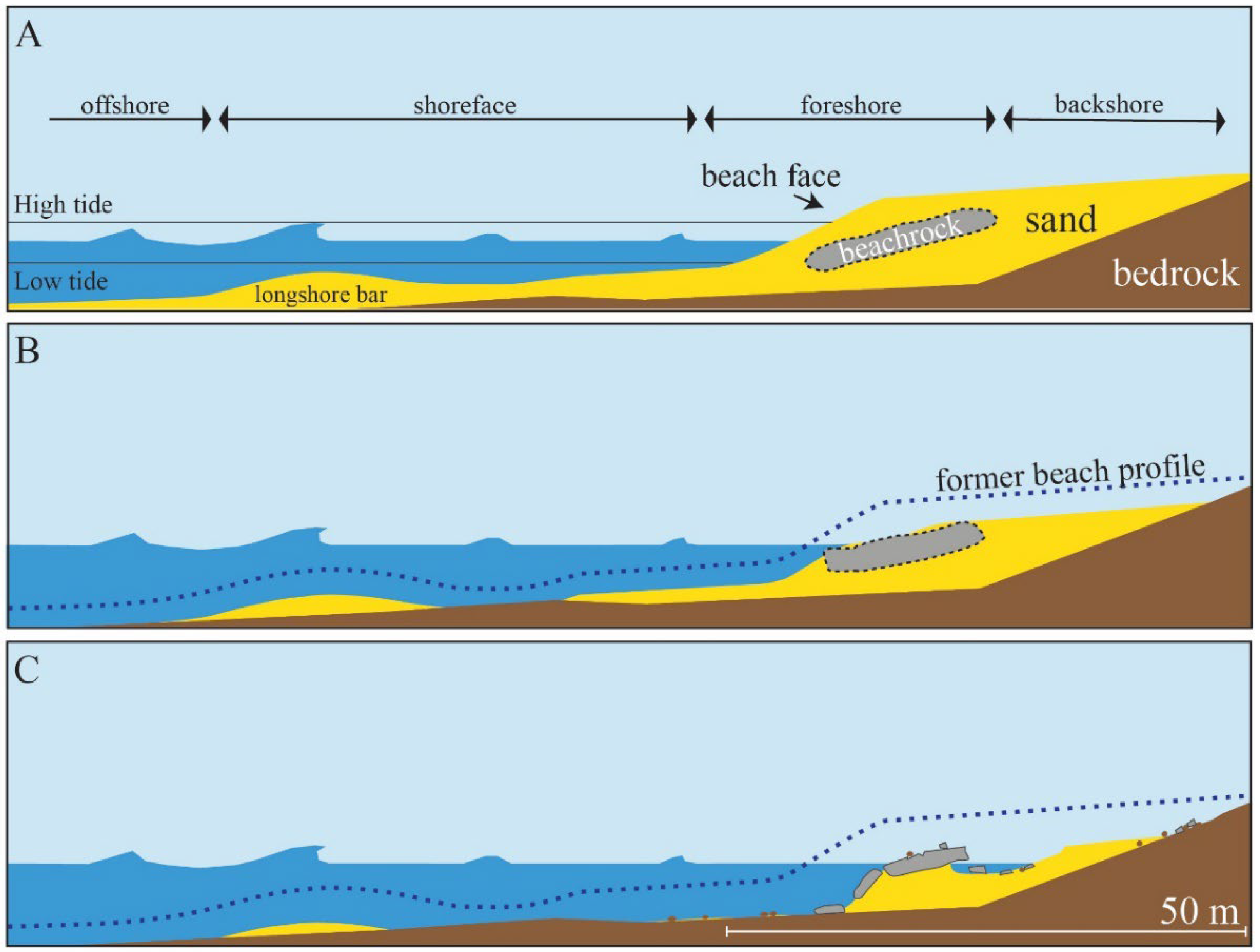
:1. Introduction
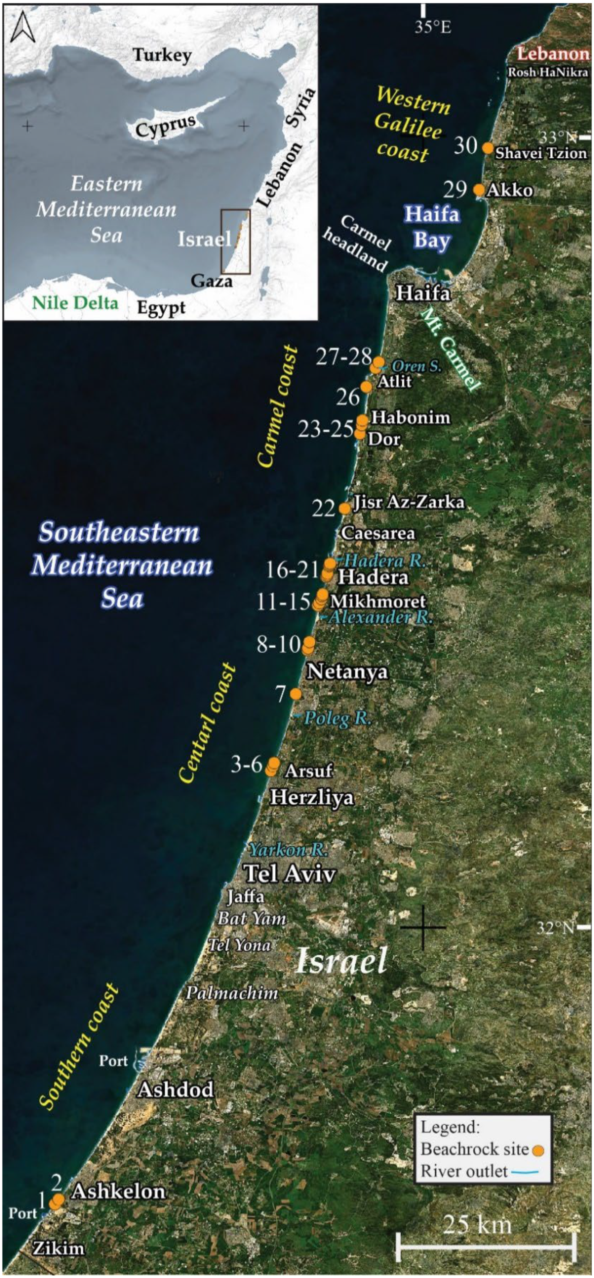
1.1. The Study Area
2. Methods
3. Results: Selected Beachrock Outcrops: Morphological Description
3.1. Southern Coast
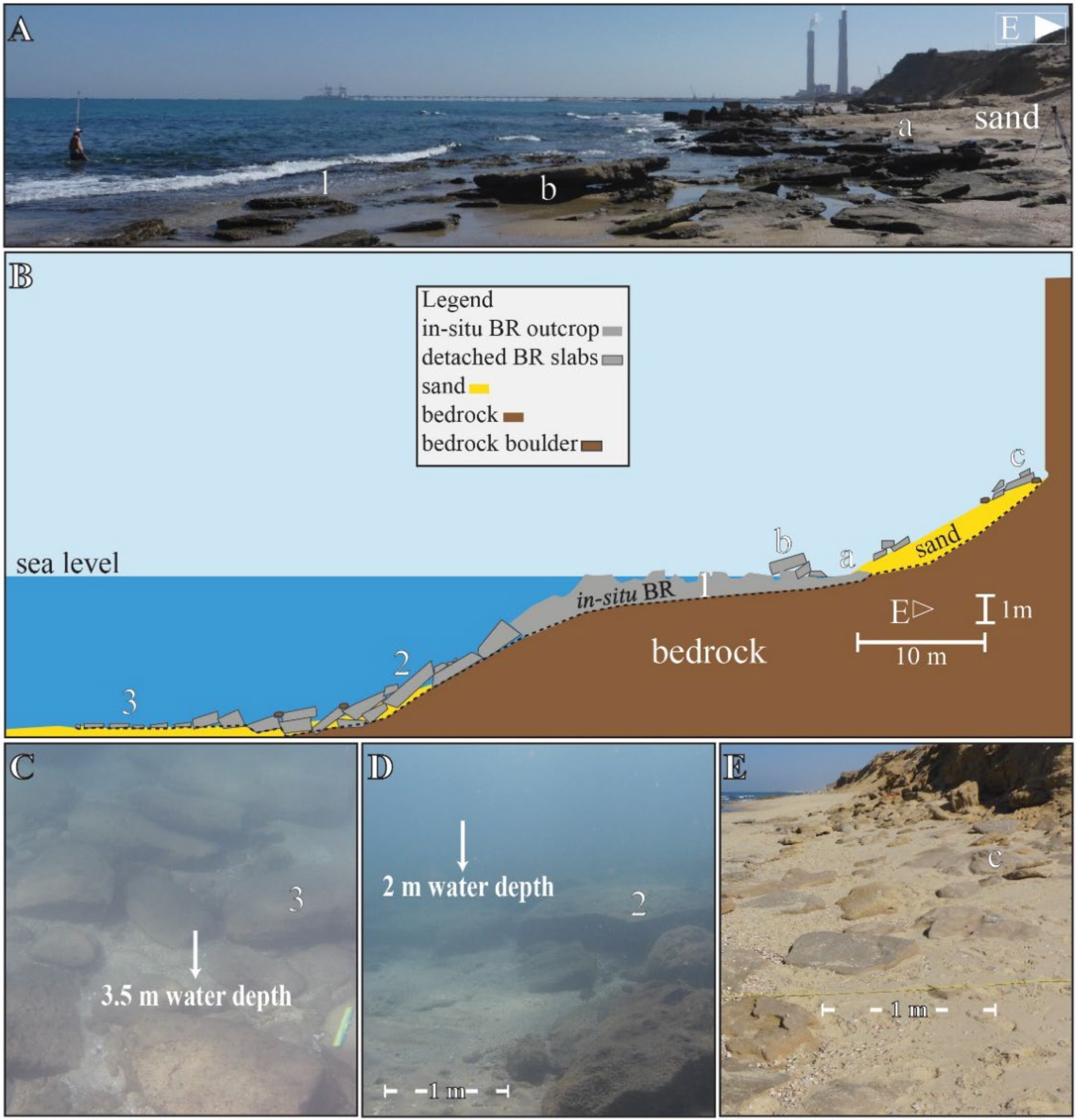
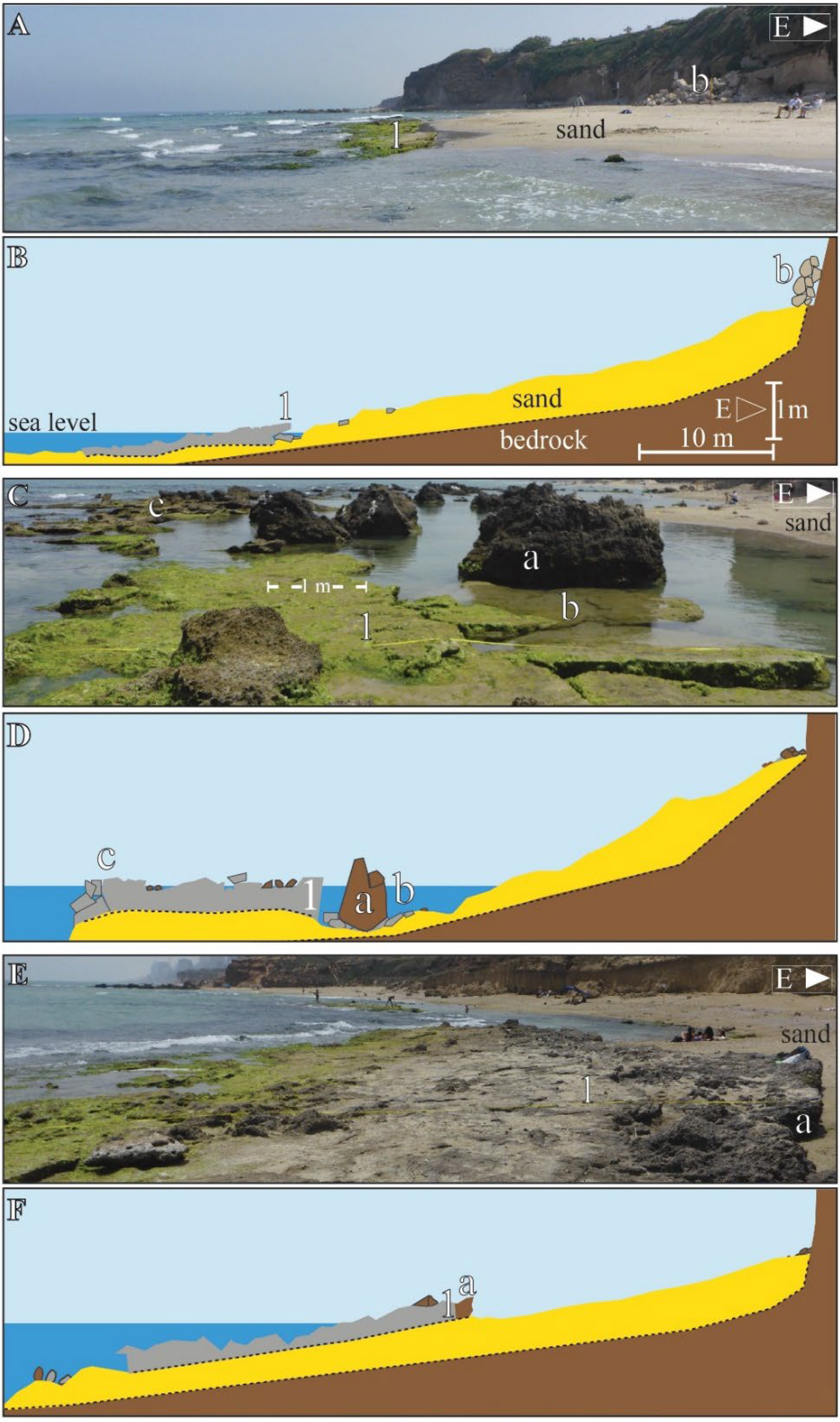
3.1.1. Ashkelon
3.2. Central Coast
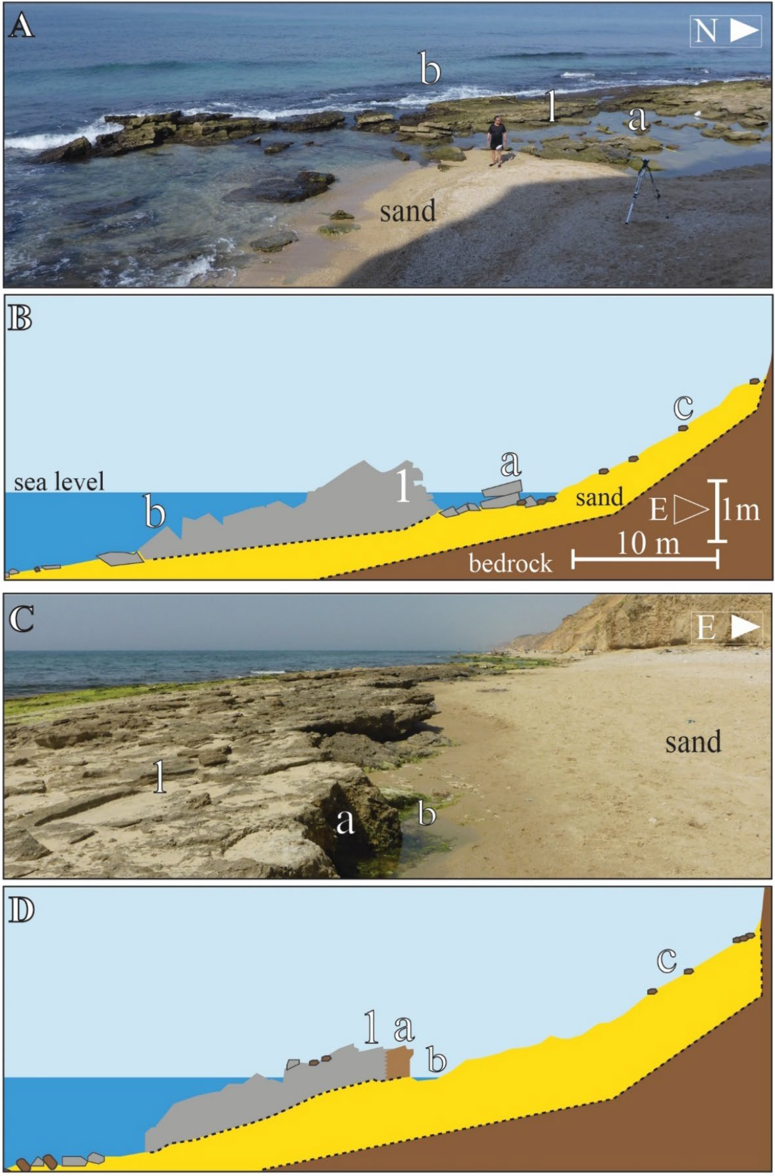
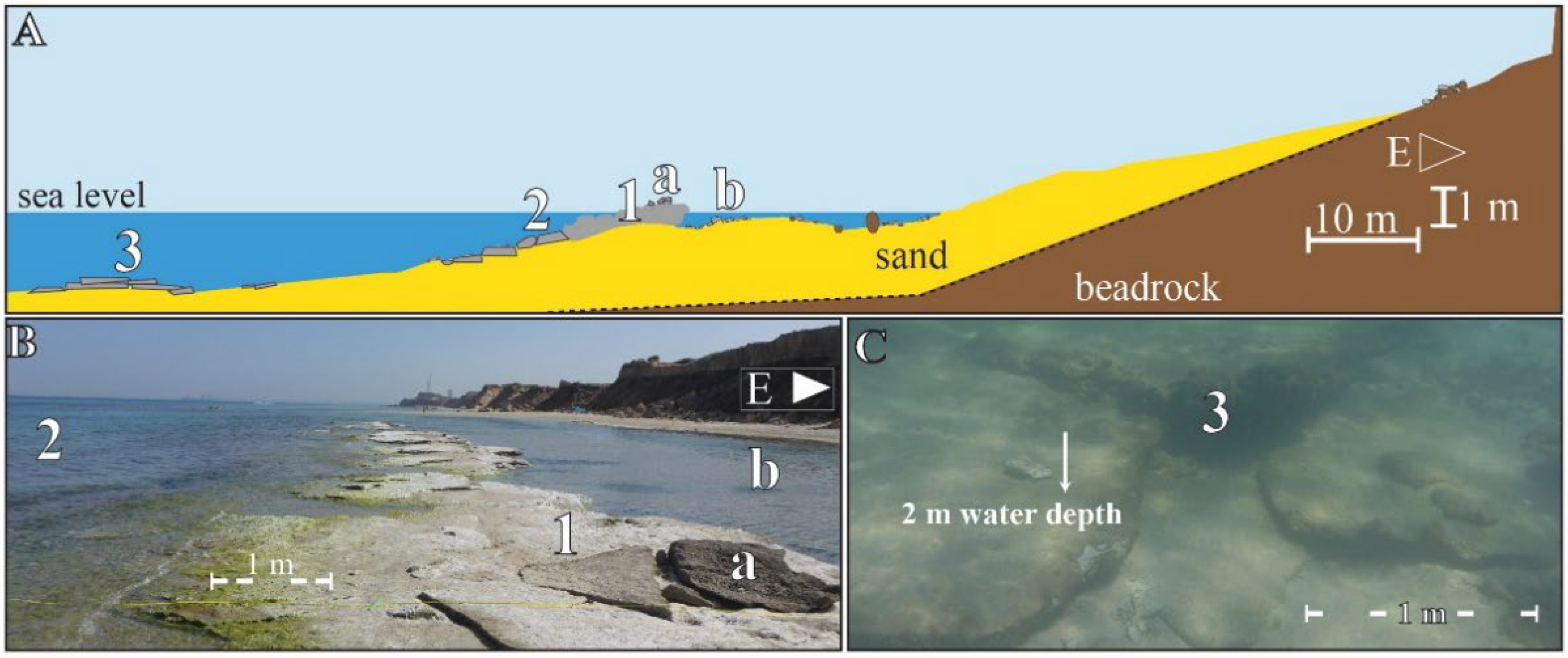
3.2.1. Southern Sharon Segment
3.2.2. Netanya Segment
3.2.3. Mikhmoret Segment
3.2.4. Hadera Segment
3.3. Carmel Coast
3.3.1. Jisr az-Zarka
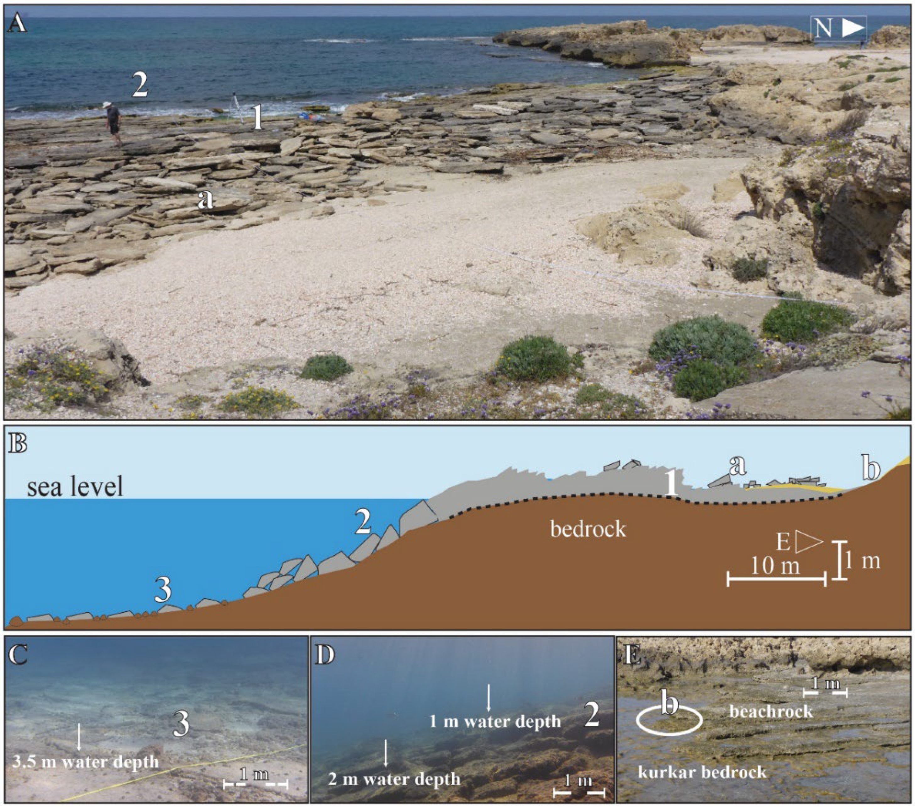
3.3.2. Habonim and Dor North
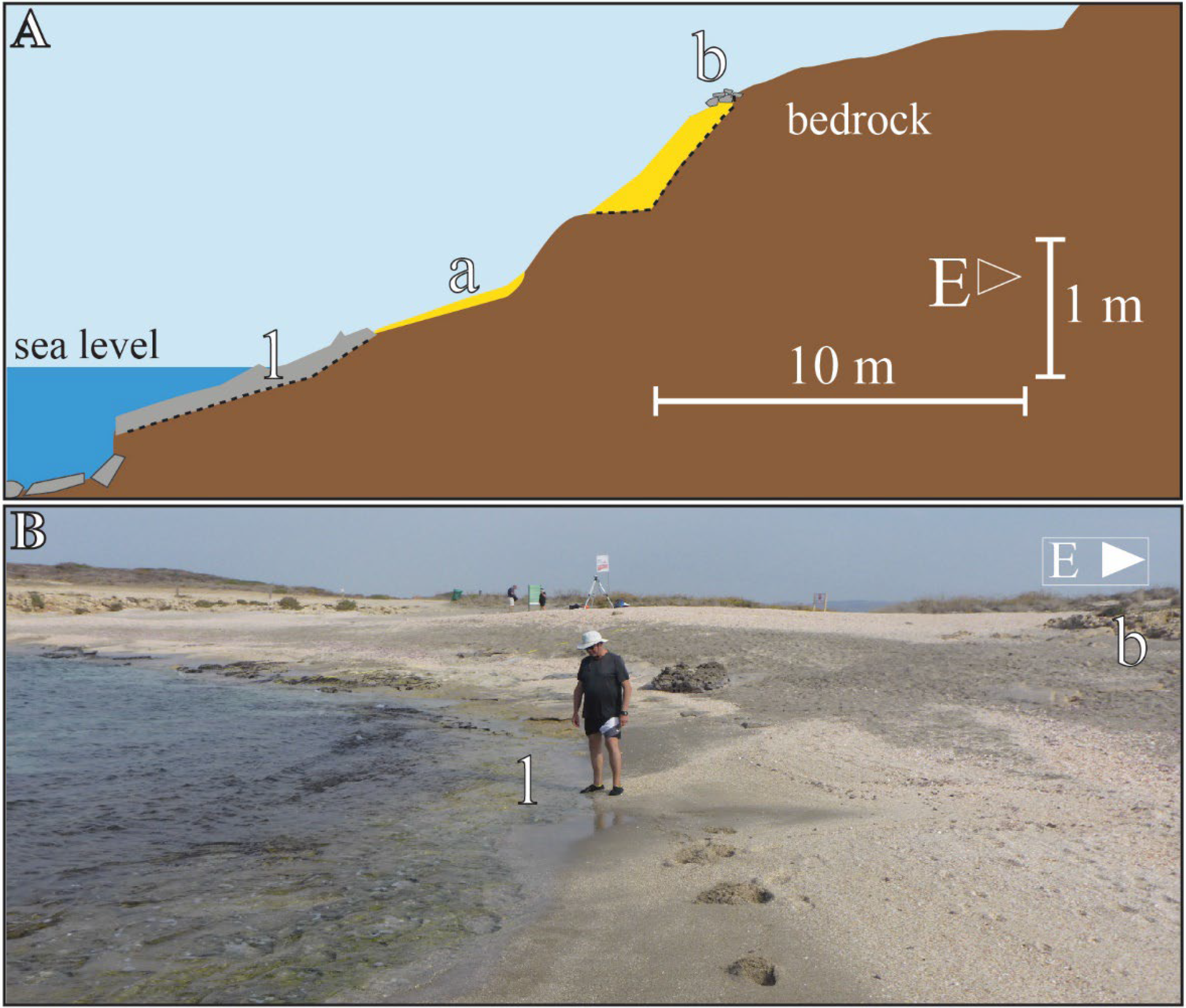
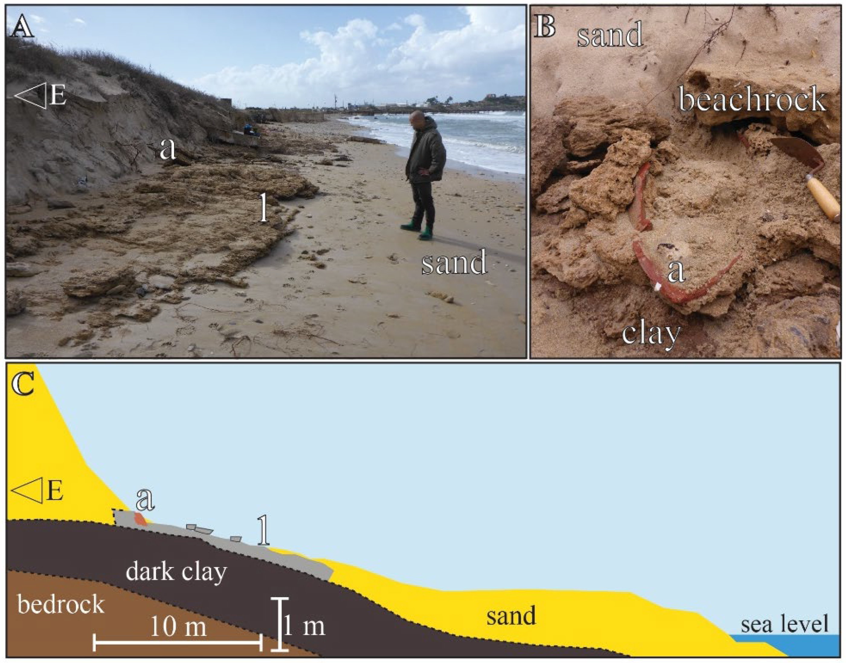
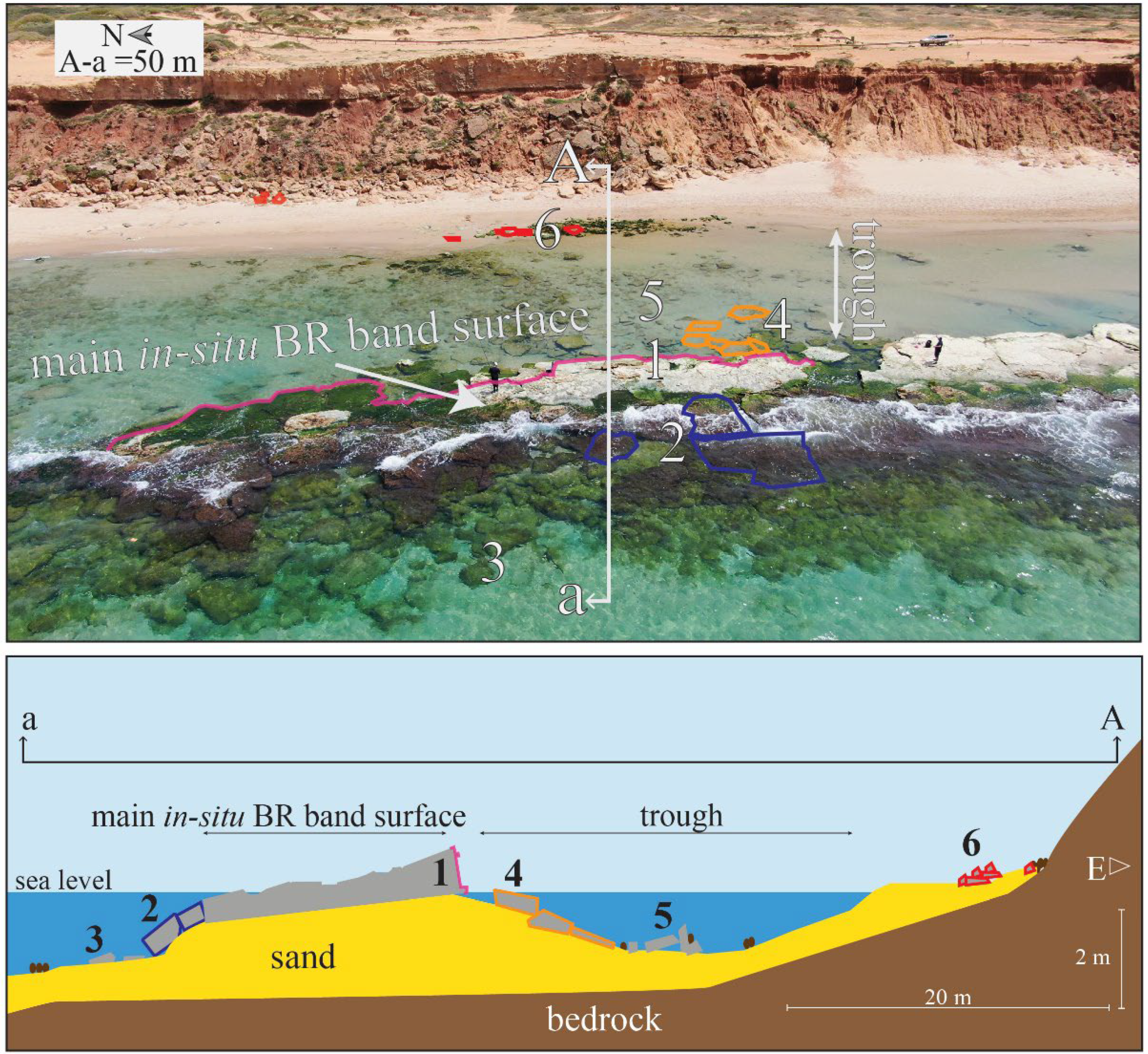
3.3.3. Atlit
- (a)
- Atlit South
- (b)
- Atlit North
3.4. Western Galilee Coast
3.4.1. Western Galilee Site I—Akko North Millstone Quarry
3.4.2. Western Galilee Site II Shavei Tzion (Beit HaEmek Stream Outlet)
3.5. Summary
4. Discussion
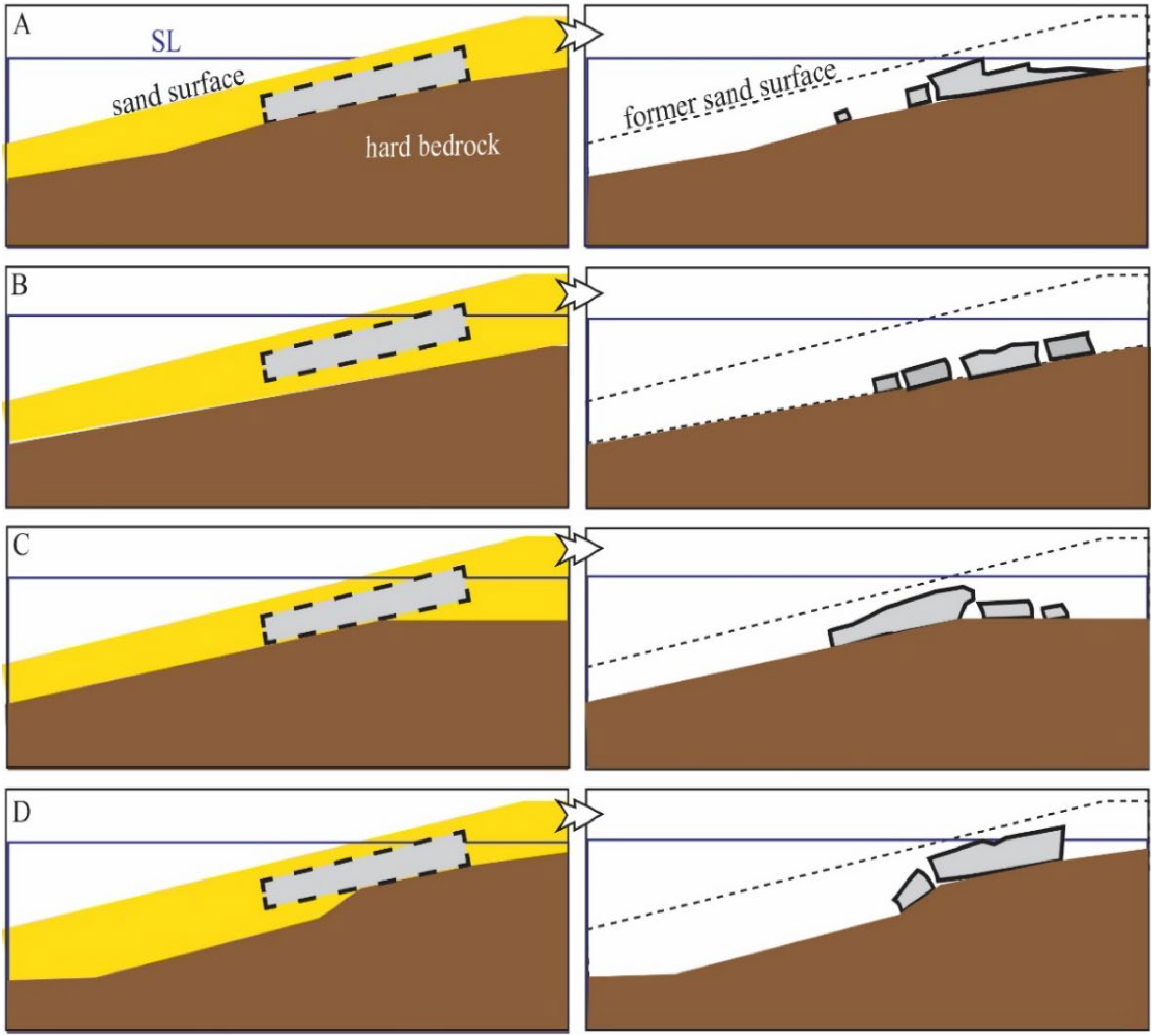
4.1. Classification of Beachrock Morphological Structures
4.2. Beachrock Exposures: A Proxy for Sandy Beach Erosion at the Mediterranean Coast of Israel
5. Conclusions
- In-situ, beachrock outcrops are subjected to marine weathering and erosion, characterized by morphological features typical of different underlying lithologies.
- Beachrock outcrops along the Israeli Mediterranean coast, located at various beach types and sites differing in coastline geometry, sediment composition, and the intensity of anthropogenic impact on the coastline, are characterized by similar typical distinctive morphological features.
- The occurrence of beachrock outcrops along considerable parts of the Mediterranean coast of Israel points to an erosion phase of sediment that once covered the beaches when the beachrock was formed.
- The occurrence of large BR sections on the seabed (up to 4.5 m bsl) and above current sea level (up to 3 m asl) does not necessarily indicate different sea levels at the time of their formation, nor tectonic changes. Erosion, scouring, and settling processes can explain their location on the sea bottom, while wave activity is responsible for their location in the foreshore and backshore.
Author Contributions
Funding
Institutional Review Board Statement
Informed Consent Statement
Acknowledgments
Conflicts of Interest
References
- Komar, P.D. Beach Processes and Sedimentation; Prentice Hall: Englewood Cliffs, NJ, USA, 1976; p. 429. [Google Scholar]
- Tucker, M.E. Sedimentary Petrology: An Introduction to the Origin of Sedimentary Rocks, 3rd ed.; Blackwell Publishing: Malden, MA, USA, 2001; p. 266. [Google Scholar]
- Danjo, T.; Kawasaki, S. Characteristics of beachrocks: A review. Geotech. Geol. Eng. 2014, 32, 215–246. [Google Scholar] [CrossRef]
- Komar, P.D. Beach processes and erosion—An introduction. In CRC Handbook of Coastal Processes and Erosion; Komar, P.D., Moore, J.R., Eds.; CRC Series in Marine Science; Taylor & Francis Group: Boca Raton, FL, USA, 1983; pp. 1–21. [Google Scholar]
- Frankel, E. Rate formation of beachrock. Earth Planet. Sci. Lett. 1968, 4, 439–440. [Google Scholar] [CrossRef]
- Neumeier, U. Experimental modelling of beachrock cementation under microbial influence. Sediment. Geol. 1999, 126, 35–46. [Google Scholar] [CrossRef]
- Friedman, G.M. Holocene chronostratigraphic beachrocks and their geologic climatic significance. In Geochemical Investigation in Earth Science; Hill, R.G., Leventhal, J., Aizenshtat, Z., Baedecker, M.J., Claypool, G., Eganhouse, R., Peters, K., Eds.; Elsevier: Amsterdam, The Netherlands, 2004; pp. 135–142. [Google Scholar]
- Vousdoukas, M.I.; Velegrakis, A.F.; Plomaritis, T.A. Beachrock occurrence, characteristics, formation mechanisms and impacts. Earth Sci. Rev. 2007, 85, 23–46. [Google Scholar] [CrossRef]
- Wiles, E.; Green, A.N.; Cooper, J.A.G. Rapid beachrock cementation on a South African beach: Linking morphodynamics and cement style. Sediment. Geol. 2018, 378, 13–18. [Google Scholar] [CrossRef]
- Cooper, J.A.G. Beachrock formation in low latitudes: Implications for coastal evolutionary models. Mar. Geol. 1991, 98, 145–154. [Google Scholar]
- Vousdoukas, M.I.; Velegrakis, A.F.; Karambas, T.V. Morphology and sedimentology of a microtidal beach with beachrocks: Vatera, Lesbos, NE Mediterranean. Cont. Shelf Res. 2009, 29, 1937–1947. [Google Scholar] [CrossRef]
- Alexandrakis, C.; Ghionis, G.; Poulos, S.S. The effect of beachrock formation on the morphological evolution of a beach, The case study of an eastern Mediterranean beach: Ammoudara, Greece. J. Coast. Res. 2013, 69, 47–59. [Google Scholar] [CrossRef]
- Mauz, B.; Vacchi, M.; Green, A.; Hoffmann, G.; Cooper, A. Beachrock: A tool for reconstructing relative sea level in the far-field. Mar. Geol. 2015, 362, 1–16. [Google Scholar] [CrossRef]
- Malta, J.V.; Castro, J.W.A.; Cabral, C.L.; Fernandes, D.; Cawthra, H.C. Genesis and age of beachrock on the Rio de Janeiro coastline, Southeast–Brazil. Mar. Geol. 2021, 442, 106649–106661. [Google Scholar] [CrossRef]
- Kelletat, D. Beachrock as sea-level indicator? Remarks from a geomorphological point of view. J. Coast. Res. 2006, 22, 1558–1564. [Google Scholar] [CrossRef]
- Knight, J. Beachrock reconsidered, discussion of: Kelletat, 2006, Beachrock as sea-level indicator? Remarks from a geomorphological point of view. J. Coast. Res. 2006, 22, 1558–1564. [Google Scholar] [CrossRef]
- Vieira, M.M.; De Ros, L.F.; Bezerra, F.H.R. Lithofaciology and palaeoenvironmental analysis of Holocene beachrocks in northeastern Brazil. J. Coast. Res. 2007, 236, 1535–1548. [Google Scholar] [CrossRef]
- Erginal, A.E.; Kiyak, N.G.; Bozcu, M.; Ertek, A.; Gunguneş, H.; Sungur, A.; Turker, G. On the origin and age of the Arıburnu beachrock, Gelibolu peninsula, Turkey. Turk. J. Earth Sci. 2008, 17, 803–819. [Google Scholar]
- Erginal, A.E.; Cüneyt, E.R.; Yıldırım, C.; Selim, H.H.; Kıyak, N.G.; Erenoğlu, O.; Ulugergerli, E.; Karabıyıkoğlu, M. Co-seismic beachrock deformation of 8th century AD earthquake in Middle Strand of North Anatolian Fault, Lake Iznik, NW Turkey. Tectonophysics 2021, 799, 228690. [Google Scholar] [CrossRef]
- Desruelles, S.; Fouache, E.; Ciner, A.; Dalongeville, R.; Pavlopoulos, K.; Kosun, E.; Coquinot, Y.; Potdevin, J.-L. Beachrocks and sea level changes since Middle Holocene: Comparison between the insular group of Mykonos–Delos–Rhenia (Cyclades, Greece) and the southern coast of Turkey. Glob. Planet. Change 2009, 66, 19–33. [Google Scholar] [CrossRef]
- Psomiadis, D.; Tsourlos, P.; Albanakis, K. Electrical resistivity tomography mapping of beachrocks: Application to the island of Thassos (N. Greece). Environ. Earth Sci. 2009, 59, 233–240. [Google Scholar] [CrossRef]
- Friedman, G.M. Beachrocks record Holocene events, including natural disasters. Carbonates Evaporites 2011, 26, 97–109. [Google Scholar] [CrossRef]
- May, S.M.; Vött, A.; Brückner, H.; Grapmayer, R.; Handl, M.; Wennrich, V. The Lefkada barrier and beachrock system (NW Greece)—Controls on coastal evolution and the significance of extreme wave events. Geomorphology 2012, 139–140, 330–347. [Google Scholar] [CrossRef]
- Kelly, C.S.; Green, A.N.; Cooper, J.A.G.; Wiles, E. Beachrock facies variability and sea level implications: A preliminary study. J. Coast. Res. 2004, 70, 736–742. [Google Scholar] [CrossRef]
- Mourtzas, N.; Kolaiti, E.; Anzidei, M. Vertical land movements and sea level changes along the coast of Crete (Greece) since Late Holocene. Quat. Int. 2016, 401, 43–70. [Google Scholar] [CrossRef]
- Meligonitis, R.; Galanopoulos, D.; Hasiotis, T.; Velegrakis, A. Geo-electrical mapping of beachrock in Vatera beach, Lesbos. Bull. Geol. Soc. Greece 2016, 50, 2323–2331. [Google Scholar] [CrossRef]
- Ozturk, M.Z.; Erginal, A.E.; Kiyak, N.G.; Ozturk, T. Cement fabrics and optical luminescence ages of beachrock, north Cyprus: Implications for Holocene sea-level changes. Quat. Int. 2016, 401, 132–140. [Google Scholar] [CrossRef]
- Karkani, A.; Evelpidou, N.; Vacchi, M.; Morhange, C.; Tsukamoto, S.; Frechend, M.; Maroukiana, H. Tracking shoreline evolution in central Cyclades (Greece) using beachrocks. Mar. Geol. 2017, 388, 25–37. [Google Scholar] [CrossRef]
- Pretorius, L.; Green, A.N.; Cooper, J.A. Submerged beachrock preservation in the context of wave ravinement. Geo-Mar. Lett. 2018, 38, 19–32. [Google Scholar] [CrossRef]
- Emmanouilidis, A.; Unkel, I.; Triantaphyllou, M.; Avramidis, P. Late-Holocene coastal depositional environments and climate changes in the Gulf of Corinth, Greece. Holocene 2020, 30, 77–89. [Google Scholar] [CrossRef]
- Polidorou, M.; Saitis, G.; Evelpidou, N. Beachrock development as an indicator of paleogeographic evolution, the case of Akrotiri Peninsula, Cyprus. Z. Für Geomorphol. 2021, 63, 3–17. [Google Scholar] [CrossRef]
- Mannaa, A.A.; Haredy, R.A.; Ghandour, I.M. Beachrock as a paleo shoreline indicator: An example from Wadi Al-Hamd, South Al-Wajh, Saudi Arabia. J. Mar. Sci. Eng. 2021, 9, 984. [Google Scholar] [CrossRef]
- Saitis, G.; Koutsopoulou, E.; Karkani, A.; Anastasatou, M.; Stamatakis, M.; Gatou, M.-A.; Evelpidou, N. A multi-analytical study of beachrock formation in Naxos and Paros Islands, Aegean Sea, Greece and their palaeoenvironmental significance. Z. Für Geomorphol. 2021, 63, 19–32. [Google Scholar] [CrossRef]
- Galili, E.; Salamon, A.; Gambash, G.; Zviely, D. Archaeological and Natural Indicators of Sea-Level and Coastal Changes: The Case Study of the Caesarea Roman Harbor. Geosciences 2021, 11, 306. [Google Scholar] [CrossRef]
- Gavish, E.; Friedman, G.M. Progressive diagenesis in Quaternary to late Tertiary carbonate sediments: Sequence and time scale. J. Sediment. Petrol. 1969, 39, 980–1006. [Google Scholar]
- Frechen, M.; Dermann, B.; Boenigk, K.; Ronen, A. Luminescence chronology of aeolianites from the section at Givat Olga—Coastal plain of Israel. Quat. Sci. Rev. 2001, 20, 805–809. [Google Scholar] [CrossRef]
- Frechen, M.; Neber, A.; Tsatskin, A.; Boenigk, W.; Ronen, A. Chronology of Pleistocene sedimentary cycles in the Carmel Coastal Plain of Israel. Quat. Int. 2004, 121, 41–52. [Google Scholar] [CrossRef]
- Tsoar, H. Geomorphology and paleogeography of sand dunes that have formed the kurkar ridges in the coastal plain of Israel. Isr. J. Earth Sci. 2000, 49, 189–196. [Google Scholar] [CrossRef]
- Porat, N.; Wintle, A.G.; Ritte, M. Mode and timing of kurkar and hamra formation, central coastal plain, Israel. Isr. J. Earth Sci. 2004, 53, 13–25. [Google Scholar] [CrossRef]
- Almagor, G.; Perath, I. Mediterranean Coast of Israel; Report GSI/28/2012; Geology Survey of Israel: Jerusalem, Israel, 2012. (In Hebrew)
- Mauz, B.; Hijma, M.P.; Amorosi, A.; Porat, N.; Galili, E.; Bloemendal, J. Aeolian beach ridges and their significance for climate and sea level: Concept and insight from the Levant coast (East Mediterranean). Earth Sci. Rev. 2013, 121, 31–54. [Google Scholar] [CrossRef]
- Shtienberg, G.; Dix, J.K.; Roskin, J.; Waldmann, N.; Bookman, R.; Bialik, O.M.; Porat, N.; Taha, N.; Sivan, D. New perspectives on coastal landscape reconstruction during the Late Quaternary: A test case from central Israel. Palaeogeogr. Palaeoclimatol. Palaeoecol. 2017, 468, 503–519. [Google Scholar] [CrossRef]
- Ronen, A. Quaternary sedimentology and prehistory on the Mediterranean coastal plain of Israel. Quat. Int. 2018, 464, 315–326. [Google Scholar] [CrossRef]
- Galili, E.; Zviely, D.; Ronen, A.; Mienis, H.K. Beach deposits of MIS 5e high sea stand as indicators for tectonic stability of the Carmel coastal plain, Israel. Quat. Sci. Rev. 2007, 26, 2544–2557. [Google Scholar] [CrossRef]
- Galili, E.; Zviely, D.; Weinstein-Evron, M. Holocene sea-level changes and landscape evolution on the northern Carmel coast (Israel). Méditerranée 2005, 104, 79–86. [Google Scholar] [CrossRef] [Green Version]
- Sivan, D.; Wdowinsk, S.; Lambeck, K.; Galili, E.; Raban, A. Holocene sea-level changes along the Mediterranean coast of Israel, based on archaeological observations and numerical model. Palaeogeogr. Palaeoclimatol. Palaeoecol. 2001, 167, 101–117. [Google Scholar] [CrossRef]
- Sivan, D.; Sisma-Ventura, G.; Greenbaum, N.; Bialik, O.M.; Williams, F.H.; Tamisiea, M.E.; Rohling, E.J.; Frumkin, A.; Avnaim-Katav, S.; Shtienberg, G.; et al. Eastern Mediterranean Sea levels through the last interglacial from a coastal-marine sequence in northern Israel. Quat. Sci. Rev. 2016, 145, 204–225. [Google Scholar] [CrossRef]
- Lichter, M.; Zviely, D.; Klein, M.; Sivan, D. Sea-level changes in the Mediterranean: Past, present, and future—A review. In Seaweeds and their Role in Globally Changing Environments; Israel, A., Einav, R., Seckbach, J., Eds.; Cellular Origin, Life in Extreme Habitats and Astrobiology 15; Springer: Berlin, Germany, 2010; pp. 3–17. [Google Scholar]
- Toker, E.; Sivan, D.; Stern, E.; Shirman, B.; Tsimplis, M.; Spada, G. Evidence for centennial scale sea level variability during the Medieval Climate Optimum (Crusader Period) in Israel, eastern Mediterranean. Earth Planet. Sci. Lett. 2012, 315–316, 51–61. [Google Scholar] [CrossRef]
- Benjamin, J.; Rovere, A.; Fontana, A.; Furlani, S.; Vacchi, M.; Inglis, R.H.; Galili, E.; Antonioli, F.; Sivan, D.; Miko, S.; et al. Late Quaternary sea-level changes and early human societies in the central and eastern Mediterranean basin: An interdisciplinary review. Quat. Int. 2017, 449, 29–57. [Google Scholar] [CrossRef] [Green Version]
- Rosen, D.S.; Kaplan, A. Environmental loads design criteria for nearshore structures improved environmental loading design criteria for nearshore structures. In Proceedings of the 30th International Conference on Coastal Engineering, San Diego, CA, USA, 3–8 September 2006; pp. 4456–4468. [Google Scholar]
- Kit, E.; Kroszynski, U. Marine Policy Plan for Israel: Physical Oceanography, Deep Sea and Coastal Zone Overview; P.N. 800/14; CAMERI—Coastal and Marine Engineering Research Institute, Technion City: Haifa, Israel, 2014. [Google Scholar]
- Zviely, D.; Kit, E.; Klein, M. Longshore sand transport estimates along the Mediterranean coast of Israel in the Holocene. Mar. Geol. 2007, 238, 61–73. [Google Scholar] [CrossRef]
- Bitan, M.; Zviely, D. Lost value assessment of bathing beaches due to sea level rise: A case study of the Mediterranean coast of Israel. J. Coast. Conserv. 2019, 23, 773–783. [Google Scholar] [CrossRef]
- Emery, K.O.; Neev, D. Mediterranean beaches of Israel. Isr. Geol. Surv. Bull. 1960, 26, 1–23. [Google Scholar]
- Pomerancblum, M. The distribution of heavy minerals and their hydraulic equivalents in sediments of the Mediterranean shelf of Israel. J. Sediment. Petrol. 1966, 36, 162–174. [Google Scholar] [CrossRef]
- Sandler, A.; Herut, B. Composition of clays along the continental shelf off Israel: Contribution of the Nile versus local source. Mar. Geol. 2000, 167, 339–354. [Google Scholar] [CrossRef]
- Almogi-Labin, A.; Calvo, R.; Elyashiv, H.; Amit, R.; Harlavan, Y.; Herut, B. Sediment Characterization of the Israeli Mediterranean Shelf (10–100 m); Report GSI/27/2012; Geology Survey of Israel: Jerusalem, Israel, 2012. (In Hebrew)
- Katz, T.; Crouvi, O. Sediment flux dynamics over the shallow (25 m depth) shelf of the Mediterranean Sea along the Israeli coast. Mar. Geol. 2018, 406, 1–11. [Google Scholar] [CrossRef]
- Inman, D.L.; Jenkins, S.A. The Nile littoral cell and man’s impact on the coastal zone of the Southeastern Mediterranean. In Proceedings of the 19th International Conference on Coastal Engineering, Houston, TX, USA, 3–7 September 1984; pp. 1600–1617. [Google Scholar]
- Almagor, G.; Gill, D.; Perath, I. Marine sand resources offshore Israel. Mar. Georesour. Geotec. 2000, 18, 1–42. [Google Scholar] [CrossRef]
- Schattner, I. Geomorphology of the northern coast of Israel. Geogr. Ann. 1967, 49, 310–320. [Google Scholar] [CrossRef]
- Schattner, I. Geomorphology: The Exogene Evolution of the Relief; Kiryath Sepher Ltd.: Jerusalem, Israel, 1970; p. 372. [Google Scholar]
- Lipkin, Y.; Safriel, U. Intertidal zonation on rocky shores at Mikhmoret (Mediterranean, Israel). J. Ecol. 1971, 59, 1–30. [Google Scholar] [CrossRef]
- Bakler, N.; Amiel, A. Morphology and mineralogy of recent beachrocks along the Mediterranean coast of Israel. In Proceedings of the Israel Geological Society Annual Meeting, Ashqelon, Israel, 1–2 June 1976; pp. 26–27. [Google Scholar]
- Magaritz, M.; Gavish, E.; Bakler, N.; Kafri, U. Carbon and oxygen isotope composition indicators of cementation environment in recent, Holocene, and Pleistocene sediments along the coast of Israel. J. Sediment. Petrol. 1979, 49, 401–412. [Google Scholar]
- Galili, E.; Zviely, D. Geo-archaeological markers reveal magnitude and rates of Israeli coastal cliff erosion and retreat. J. Coast. Conserv. 2019, 23, 747–785. [Google Scholar] [CrossRef]
- Mushkin, A.; Katz, O.; Porat, N. Overestimation of short-term coastal cliff retreat rates in the eastern Mediterranean resolved with a sediment budget approach. Earth Surf. Process. Landf. 2019, 44, 179–190. [Google Scholar] [CrossRef] [Green Version]
- Tucker, M.E. Sedimentary Rocks in the Field: A Practical Guide, 4th ed.; Wiley-Blackwell: Durham, UK, 2004; p. 257. [Google Scholar]
- Cooper, J.A.G.; Green, A.N.; Vital, H.; Lima-Filho, F.P. Geomorphology and clast assemblages of intertidal beachrock: Implications for submerged shoreline preservation. Geomorphology 2019, 343, 106–118. [Google Scholar] [CrossRef]
- Galili, E.; Weinstein-Evron, M.; Ronen, A. Holocene sea-level changes based on submerged archaeological sites off the Northern Carmel coast in Israel. Quat. Res. 1988, 29, 36–42. [Google Scholar] [CrossRef]
- Raban, A. The Phoenician Harbour and “Fishing Village” at ʿAtlit. Eretz-Isr. 1996, 25, 490–508. Available online: https://www.jstor.org/stable/23629674 (accessed on 1 October 2022). (In Hebrew).
- Galili, E.; Sharvit, J. A millstone quarry on the ‘Akko coastline. Atiqot 2001, XLII, 73–78. (In Hebrew) [Google Scholar]
- Hastie, W.W.; Mthembu, A.T.; Green, A.N.; Van den Bergh, J. Linking fracturing and rock mechanical properties to the erosion of a beachrock shore platform. Mar. Geol. 2021, 441, 106616. [Google Scholar] [CrossRef]
- Lewis, D.W.; McConchie, D. Practical Sedimentology, 2nd ed.; Springer Science + Business Media: Dordrecht, Holland, 1994; p. 221. [Google Scholar] [CrossRef]
- Pilkey, O.H.; Neal, W.J.; Cooper, J.A.G.; Kelley, J.T. The World’s Beaches: A Global Guide to the Science of the Shoreline; University of California Press: Berkeley, CA, USA, 2011; p. 302. [Google Scholar]
- Pranzini, E.; Lilian, W.; Williams, A.T. Aspects of coastal erosion and protection in Europe. J. Coast. Conserv. 2015, 19, 445–459. [Google Scholar] [CrossRef]
- Bitan, M.; Zviely, D. Sand beach nourishment: Experience from the Mediterranean coast of Israel. J. Mar. Sci. Eng. 2020, 8, 273. [Google Scholar] [CrossRef] [Green Version]
- Dean, S.; Horton, B.P.; Evelpidou, N.; Cahill, N.; Spada, G.; Sivan, D. Can we detect centennial sea-level variations over the last three thousand years in Israeli archaeological records? Quat. Sci. Rev. 2019, 210, 125–135. [Google Scholar] [CrossRef]


| Site Name (No.) | Coordinates (Lat./Lon.) | Beach Type | Sub-Layer Lithology | Backshore Width (m) | BR Width (m) | BR Height (cm) | BR Main Clastic Components |
|---|---|---|---|---|---|---|---|
| Ashkelon I (1) | 31°39′05” N 34°32′05” E | Archaeological Tel | kurkar | 20 | 55 | 30 | QS, S, RI |
| Ashkelon II (2) | 31°39′27” N 34°32′21” E | sandy, Archaeological Tel | kurkar | 25 | 22 | 60 | QS, S |
| Arsuf I (3) | 32°11′54” N 34°48′26” E | sandy | kurkar | 30 | 14 | 60 | KG, S |
| Arsuf II (4) | 34°48′36” N 32°12′16” E | sandy | kurkar | 22 | 23 | 60 | KG, S |
| Arsuf III (5) | 34°48′42” N 32°12′32” E | sandy | kurkar | 30 | 17 | 50 | KG, S |
| Arsuf IV (6) | 32°12′29” N 34°48′41” E | sandy | kurkar | 30 | 13 | 40 | KG, S |
| Netanya I (7) | 32°17′43” N 34°50′20” E | sandy | kurkar | 20 | 12 | 20 | KG, S |
| Netanya II (8) | 32°21′03” N 34°51′14” E | sandy | kurkar | 28 | 14 | 25 | KG, S |
| Netanya III (9) | 32°21′12” N 34°51′16” E | sandy | kurkar | 34 | 15 | 70 | KG, S |
| Netanya IV (10) | 32°21′39” N 34°51′22” E | sandy | kurkar | 30 | 30 | 30 | KG, S |
| Mikhmoret I (11) | 32°24′25” N 34°52′01” E | sandy | kurkar | 25 | 12 | 30 | KG, S |
| Mikhmoret II (12) | 32°24′36” N 34°52′07” E | sandy | kurkar | 40–44 | 10–12 | 15–25 | KG, S |
| Gador I (13) | 32°24′55” N 34°52′16” E | sandy | kurkar | 63 | 10 | 80 | KG, S |
| Gador II (14) | 32°25′09” N 34°52′19” E | sandy | kurkar | 60 | 17 | 68 | KG, S |
| Gador III (15) | 32°25′16” N 34°52′22” E | sandy | kurkar | 42 | 10 | 55 | KG, S |
| Binyamin Cove I (16) | 32°26′36” N 34°52′39” E | sandy-pebbles | kurkar | 12–17 | 8–10 | 20 | KG, S |
| Binyamin Cove II (17) | 32°26′42” N 34°52′42” E | sandy | kurkar | 2 | 9 | 30 | KG, S |
| Angler Cove (18) | 32°26′51” N 34°52′44” E | sandy | kurkar | 44–58 | 40 | 20–54 | KG, S |
| Hadera River I (19) | 32°27′24” N 34°52′51” E | sandy | kurkar | 68 | 30 | 66 | KG, S |
| Hadera River II (20) | 32°27′30” N 34°52′54” E | sandy | kurkar | 70 | 20 | 12 | KG, S |
| Hadera River III (21) | 32°27′36” N 34°52′56” E | sandy | kurkar | 50 | 11 | 40 | KG, S |
| Jisr az-Zarka (22) | 32°31′45” N 34°54′03” E | sandy | Kurkar | 40 | 30 | 30 | KG |
| Habonim—Dor I (23) | 32°37′26” N 34°55′11” E | rocky | kurkar | 55 | 70 | 80 | S, RI |
| Habonim—Dor II (24) | 32°38′07” N 34°55′19” E | rocky | kurkar | 12 | 2 | 20 | S |
| Habonim—Dor III (25) | 32°38′27” N 34°55′23” E | rocky | kurkar | 20 | 6 | 20 | S |
| Atlit I (26) | 32°40′59” N 34°55′41” E | rocky | kurkar | 65 | 20 | 80 | BS |
| Atlit II (27) | 32°42′25” N 34°56′23” E | sandy | clay | 35 | 10 | 20 | BS, CI |
| Atlit III (28) | 32°42′51” N 34°56′37” E | sandy | clay | 40 | 4 | 20 | BS |
| Akko North millstone quarry (29) | 32°55′55” N 35°04′14” E | rocky | kurkar | 30 | 28 | 80 | BS, CI |
| Shavei Tzion Beit HaEmek Stream outlet (30) | 32°59′05” N 35°04′54” E | rocky | kurkar | 60 | 60 | 100 | BS, S, RI |
Publisher’s Note: MDPI stays neutral with regard to jurisdictional claims in published maps and institutional affiliations. |
© 2022 by the authors. Licensee MDPI, Basel, Switzerland. This article is an open access article distributed under the terms and conditions of the Creative Commons Attribution (CC BY) license (https://creativecommons.org/licenses/by/4.0/).
Share and Cite
Bar, A.; Bookman, R.; Galili, E.; Zviely, D. Beachrock Morphology along the Mediterranean Coast of Israel: Typological Classification of Erosion Features. J. Mar. Sci. Eng. 2022, 10, 1571. https://doi.org/10.3390/jmse10111571
Bar A, Bookman R, Galili E, Zviely D. Beachrock Morphology along the Mediterranean Coast of Israel: Typological Classification of Erosion Features. Journal of Marine Science and Engineering. 2022; 10(11):1571. https://doi.org/10.3390/jmse10111571
Chicago/Turabian StyleBar, Amir, Revital Bookman, Ehud Galili, and Dov Zviely. 2022. "Beachrock Morphology along the Mediterranean Coast of Israel: Typological Classification of Erosion Features" Journal of Marine Science and Engineering 10, no. 11: 1571. https://doi.org/10.3390/jmse10111571