

A Comparative Study of the Effects of Earthquakes in Different Countries on Target Displacement in Mid-Rise Regular RC Structures
 , ,
, ,  ,
,  , ,
, ,  ,
,  , and
, and 
Abstract
:1. Introduction
2. Seismicity of the Selected Countries
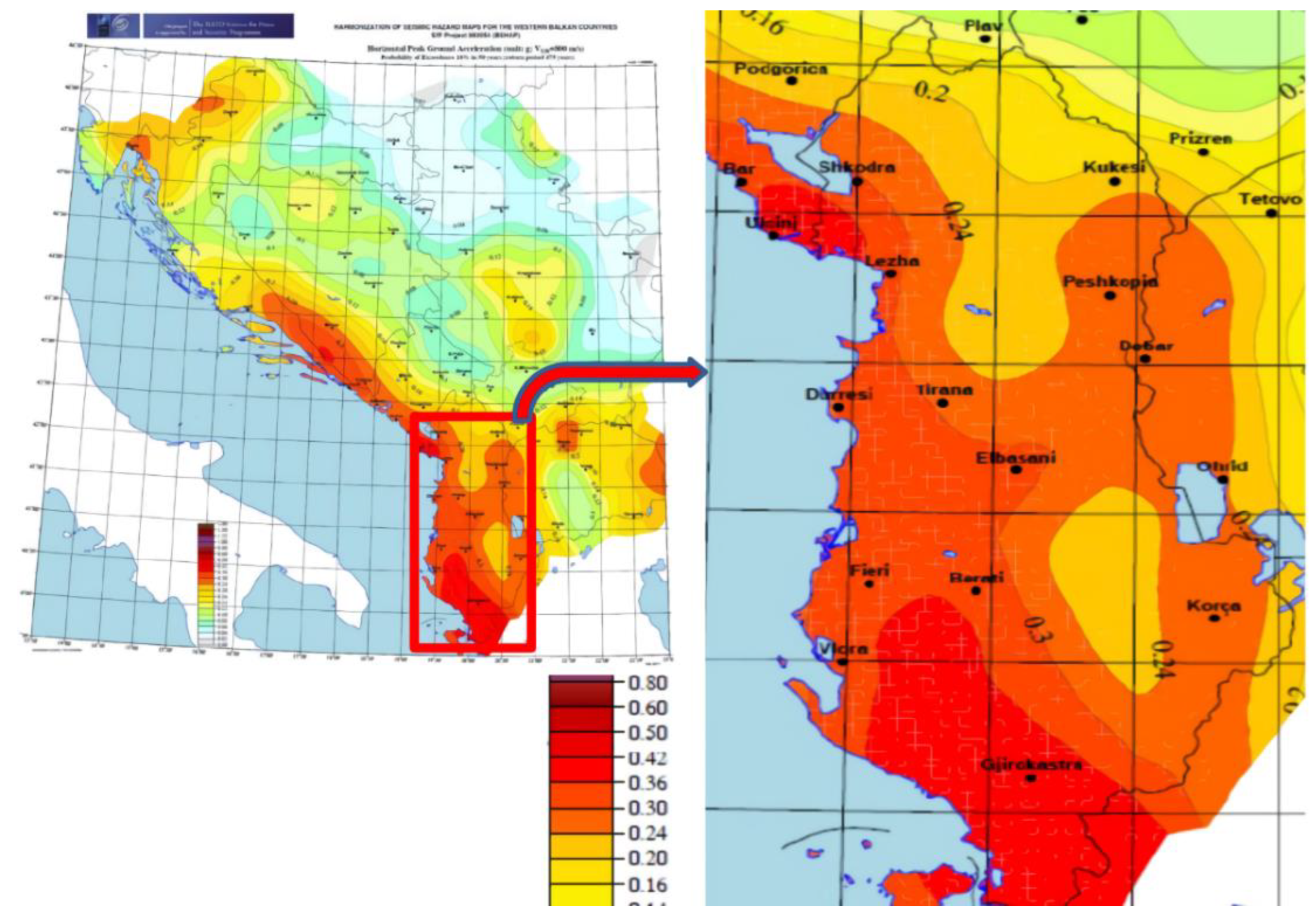
2.1. Albania
| 1. Zone of Lezha-Ulqin | 2. Zone of Peri-Adriatic Lowland |
| 3. Zone of Ionian Coast | 4. Zone of Korca-Ohrid |
| 5. Zone of Elbasan-Diber/Tetova | 6. Zone of Kukes-Peshkopi |
| 7. Zone of Shkodra-Tropoja | 8. Zone of Peja-Prizren |
| 9. Zone of Skopje |
2.2. Bosnia and Herzegovina

2.3. Croatia
2.4. Serbia
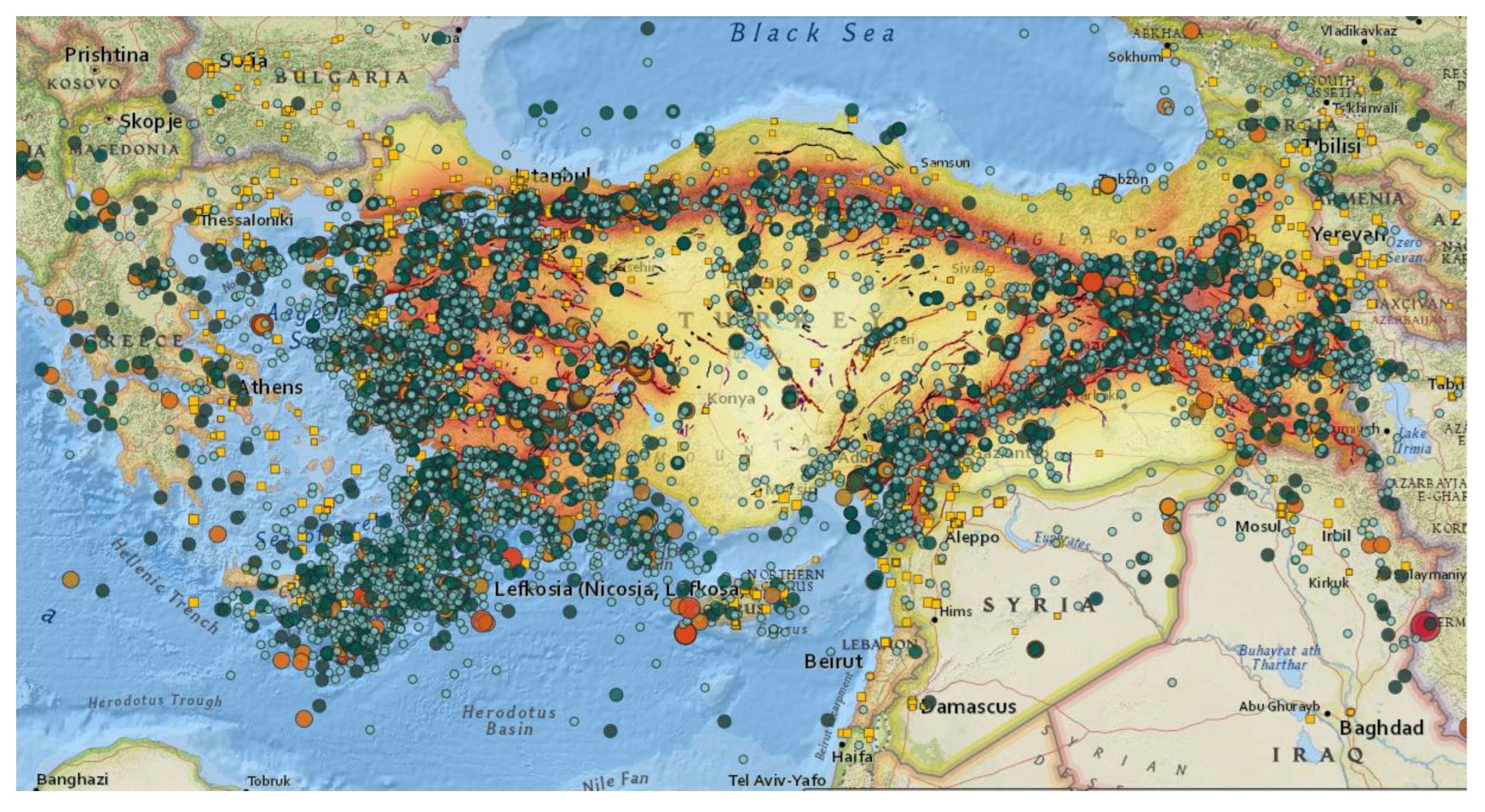
2.5. Türkiye
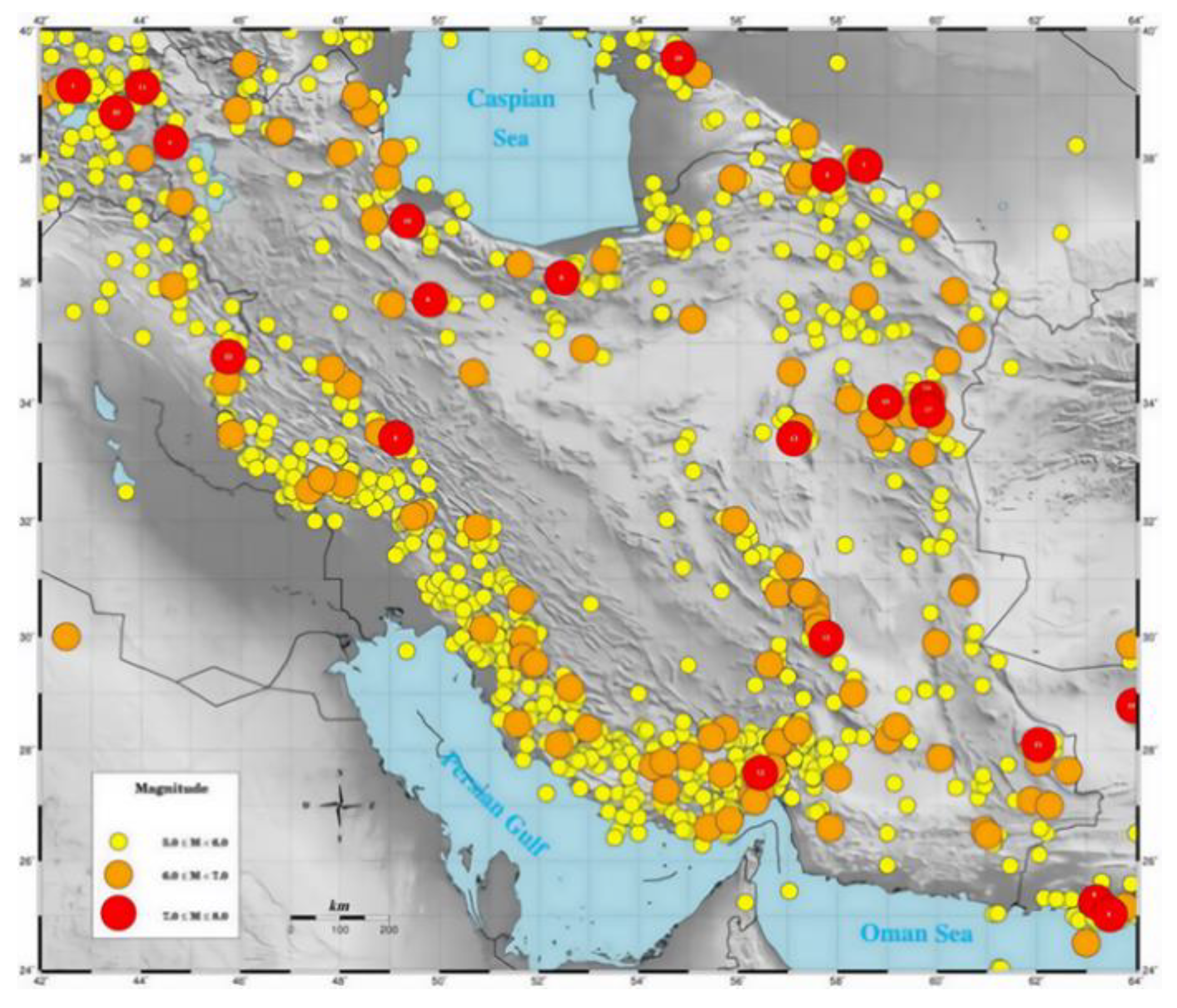
2.6. Iran
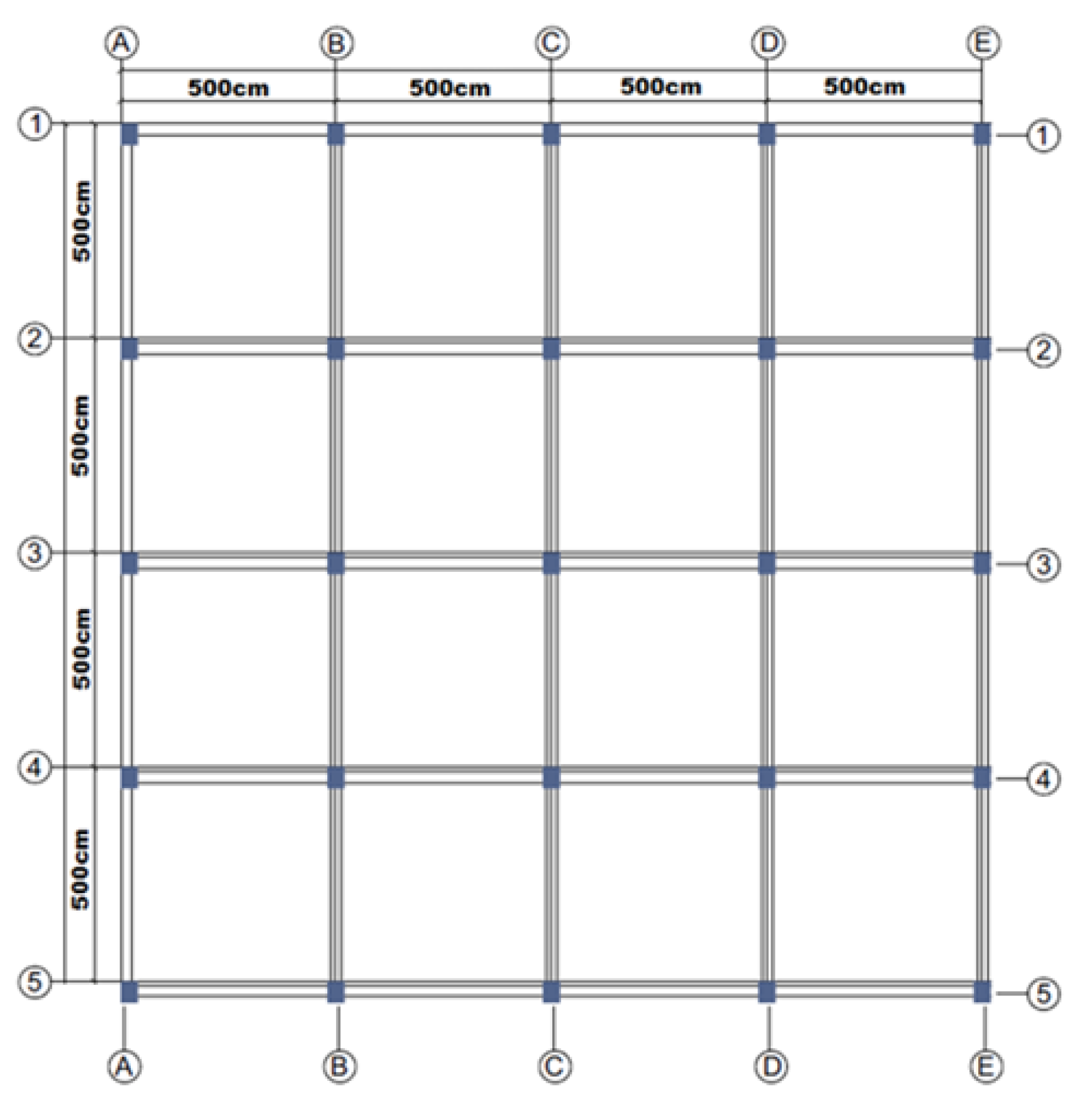
3. RC Building Models for Numerical Analysis
4. Structural Analyses Results
4.1. Comparison of Natural Fundamental Periods
4.2. Comparisons of Limit States
4.3. Evaluation of Existing Building Stocks
4.3.1. Albania
4.3.2. Bosnia and Herzegovina
4.3.3. Croatia
4.3.4. Serbia
4.3.5. Türkiye
4.3.6. Iran
5. Results and Conclusions
Author Contributions
Funding
Institutional Review Board Statement
Informed Consent Statement
Data Availability Statement
Conflicts of Interest
References
- Kumar, S.; Gupta, V.; Kumar, P.; Sundriyal, Y.P. Coseismic landslide hazard assessment for the future scenario earthquakes in the Kumaun Himalaya, India. Bull. Eng. Geol. Environ. 2021, 80, 5219–5235. [Google Scholar] [CrossRef]
- Işik, M.F.; Işik, E.; Harirchian, E. Application of IOS/Android rapid evaluation of post-earthquake damages in masonry buildings. Gazi Mühendislik Bilimleri Derg. 2021, 7, 36–50. [Google Scholar]
- Sandhu, M.; Sharma, B.; Mittal, H.; Chingtham, P. Analysis of the site effects in the North East region of India using the recorded strong ground motions from moderate earthquakes. J. Earthq. Eng. 2022, 26, 1480–1499. [Google Scholar] [CrossRef]
- Halder, L.; Dutta, S.C.; Sharma, R.P.; Bhattacharya, S. Lessons learnt from post-earthquake damage study of Northeast India and Nepal during last ten years: 2021 Assam earthquake, 2020 Mizoram earthquake, 2017 Ambasa earthquake, 2016 Manipur earthquake, 2015 Nepal earthquake, and 2011 Sikkim earthquake. Soil Dyn. Earthq. Eng. 2021, 151, 106990. [Google Scholar] [CrossRef]
- Işık, E.; Sağır, Ç.; Tozlu, Z.; Ustaoğlu, Ü.S. Determination of Urban Earthquake Risk for Kırşehir, Turkey. Earth Sci. Res. J. 2019, 23, 237–247. [Google Scholar] [CrossRef] [Green Version]
- Hoveidae, N.; Fathi, A.; Karimzadeh, S. Seismic damage assessment of a historic masonry building under simulated scenario earthquakes: A case study for Arge-Tabriz. Soil Dyn. Earthq. Eng. 2021, 147, 106732. [Google Scholar] [CrossRef]
- Tabrizikahou, A.; Hadzima-Nyarko, M.; Kuczma, M.; Lozančić, S. Application of shape memory alloys in retrofitting of masonry and heritage structures based on their vulnerability revealed in the Bam 2003 earthquake. Materials 2021, 14, 4480. [Google Scholar] [CrossRef] [PubMed]
- Ertuncay, D.; Malisan, P.; Costa, G.; Grimaz, S. Impulsive signals produced by earthquakes in Italy and their potential relation with site effects and structural damage. Geosciences 2021, 11, 261. [Google Scholar] [CrossRef]
- Ditommaso, R.; Iacovino, C.; Auletta, G.; Parolai, S.; Ponzo, F.C. Damage detection and localization on real structures subjected to strong motion earthquakes using the curvature evolution method: The Navelli (Italy) case Study. Appl. Sci. 2021, 11, 6496. [Google Scholar] [CrossRef]
- Ozmen, H.B. A view on how to mitigate earthquake damages in turkey from a civil engineering perspective. Res. Eng. Struct. Mater. 2021, 7, 1–11. [Google Scholar] [CrossRef]
- Zuo, H.; Bi, K.; Hao, H.; Ma, R. Influences of ground motion parameters and structural damping on the optimum design of inerter-based tuned mass dampers. Eng. Struct. 2021, 227, 111422. [Google Scholar] [CrossRef]
- Felicetta, C.; Mascandola, C.; Spallarossa, D.; Pacor, F.; Hailemikael, S.; Di Giulio, G. Quantification of site effects in the Amatrice area (Central Italy): Insights from ground-motion recordings of the 2016–2017 seismic sequence. Soil Dyn. Earthq. Eng. 2021, 142, 106565. [Google Scholar] [CrossRef]
- Mase, L.Z.; Likitlersuang, S.; Tobita, T. Ground motion parameters and resonance effect during strong earthquake in northern Thailand. Geotech. Geol. Eng. 2021, 39, 2207–2219. [Google Scholar] [CrossRef]
- Bilgin, H.; Shkodrani, N.; Hysenlliu, M.; Ozmen, H.B.; Isik, E.; Harirchian, E. Damage and performance evaluation of masonry buildings constructed in 1970s during the 2019 Albania earthquakes. Eng. Fail. Anal. 2022, 131, 105824. [Google Scholar] [CrossRef]
- Kamal, M.; İnel, M. Correlation between Ground motion parameters and displacement demands of mid-rise rc buildings on soft soils. Buildings 2021, 12, 125. [Google Scholar] [CrossRef]
- Gijini, A.; Cullufi, H.; Deneko, E.; Xhika, P. Behavior of structure type 82/2 (RC frame), during the earthquake of 26 November 2019 in Durrës, Albania. Res. Eng. Struct. Mater. 2021, 7, 595–615. [Google Scholar] [CrossRef]
- Bulajić, B.Đ.; Pavić, G.; Hadzima-Nyarko, M. PGA vertical estimates for deep soils and deep geological sediments–A case study of Osijek (Croatia). Comput. Geosci. 2022, 158, 104985. [Google Scholar] [CrossRef]
- Işık, E. Comparative investigation of seismic and structural parameters of earthquakes (M ≥ 6) after 1900 in Turkey. Arab. J. Geosci. 2022, 15, 971. [Google Scholar] [CrossRef]
- Nayak, C.B. A state-of-the-art review of vertical ground motion (VGM) characteristics, effects and provisions. Innov. Infrast. Solut. 2021, 6, 124. [Google Scholar] [CrossRef]
- Bhanu, V.; Chandramohan, R.; Sullivan, T.J. Influence of ground motion duration on the dynamic deformation capacity of reinforced concrete frame structures. Earthq. Spectra 2021, 37, 2622–2637. [Google Scholar] [CrossRef]
- Todorov, B.; Billah, A.M. Seismic fragility and damage assessment of reinforced concrete bridge pier under long-duration, near-fault, and far-field ground motions. Structures 2021, 31, 671–685. [Google Scholar] [CrossRef]
- Silva, V.; Crowley, H.; Pagani, M.; Monelli, D.; Pinho, R. Development of the OpenQuake engine, the Global Earthquake Model’s open-source software for seismic risk assessment. Nat. Hazards 2014, 72, 1409–1427. [Google Scholar] [CrossRef]
- Hancilar, U.; Tuzun, C.; Yenidogan, C.; Erdik, M. ELER software–a new tool for urban earthquake loss assessment. Nat. Hazards Earth Syst. Sci. 2010, 10, 2677–2696. [Google Scholar] [CrossRef] [Green Version]
- Crowley, H.; Pinho, R.; Bommer, J.J. A probabilistic displacement-based vulnerability assessment procedure for earthquake loss estimation. Bull. Earthq. Eng. 2004, 2, 173–219. [Google Scholar] [CrossRef]
- EZ-FRISK. Available online: https://www.ez-frisk.com/ (accessed on 13 November 2022).
- Nahar, T.T.; Rahman, M.M.; Kim, D. Effective safety assessment of aged concrete gravity dam based on the reliability index in a seismically induced site. Appl. Sci. 2021, 11, 1987. [Google Scholar]
- McGuire, R.K. FRISK: Computer program for seismic risk analysis using faults as earthquake sources. US Geol. Surv. 1978, 78, 1007. [Google Scholar]
- Ordaz, M.; Martinelli, F.; D’Amico, V.; Meletti, C. CRISIS2008: A flexible tool to perform probabilistic seismic hazard assessment. Seismol. Res. Lett. 2013, 84, 495–504. [Google Scholar] [CrossRef]
- Bender, B.; Perkins, D.M. SEISRISK III: A Computer Program for Seismic Hazard Estimation; (No. 1772); US Government Printing Office: Washington, DC, USA, 1987.
- Field, E.H.; Jordan, T.H.; Cornell, C.A. A developing community-modeling environment for seismic hazard analysis. Seismol. Res. Lett. 2003, 74, 406–419. [Google Scholar] [CrossRef]
- Özener, P. Dinamik Yükler, Yer Hareketi Parametreleri ve İvme Spektrumları, Yıldız Tenk Üniversitesi, Ders Notları. Available online: https://studylibtr.com/doc/1406240/ders-2.1-dinamik-y%C3%BCkler--yer-hareketi-parametreleri-ve-i%CC%87vme (accessed on 11 November 2022).
- Büyüksaraç, A.; Över, S.; Geneş, M.C.; Bikçe, M.; Kacin, S.; Bektaş, Ö. Estimating shear wave velocity using acceleration data in Antakya (Turkey). Earth Sci. Res. J. 2004, 18, 87–98. [Google Scholar]
- Pejovic, J.R.; Serdar, N.N.; Pejovic, R.R. Optimal intensity measures for probabilistic seismic demand models of RC high-rise buildings. Earthq. Struct. 2017, 13, 221–230. [Google Scholar]
- Tao, D.; Ma, Q.; Li, S.; Xie, Z.; Lin, D.; Li, S. Support vector regression for the relationships between ground motion parameters and macroseismic intensity in the Sichuan–Yunnan Region. Appl. Sci. 2020, 10, 3086. [Google Scholar] [CrossRef]
- Işık, E.; Peker, F.; Büyüksaraç, A. The effect of vertical earthquake motion on steel structures behaviour in different seismic zones. J. Adv. Res. Nat. Appl. Sci. 2022, 8, 527–542. [Google Scholar] [CrossRef]
- Liu, J.; Wang, W.; Dasgupta, G. Pushover analysis of underground structures: Method and application. Sci. China Technol. Sci. 2014, 57, 423–437. [Google Scholar] [CrossRef]
- Elnashai, A.S. Advanced inelastic static (pushover) analysis for earthquake applications. Struct. Eng. Mech. 2001, 12, 51–69. [Google Scholar] [CrossRef]
- Shendkar, M.R.; Kontoni, D.P.N.; Işık, E.; Mandal, S.; Maiti, P.R.; Harirchian, E. Influence of masonry infill on seismic design factors of reinforced-concrete buildings. Shock Vib. 2022, 2022, 5521162. [Google Scholar] [CrossRef]
- Chopra, A.K.; Goel, R.K. A modal pushover analysis procedure for estimating seismic demands for buildings. Earthq. Eng. Struct. Dyn. 2002, 31, 561–582. [Google Scholar] [CrossRef] [Green Version]
- Rofooeil, F.; Attari, N.K.; Shodja, A.; Rasekh, A. Comparison of static and dynamic pushover analysis in assessment of the target displacement. Int. J. Civ. Eng. 2006, 4, 212–225. [Google Scholar]
- Krawinkler, H.; Seneviratna, G.D.P.K. Pros and cons of a pushover analysis of seismic performance evaluation. Eng. Struct. 1998, 20, 452–464. [Google Scholar] [CrossRef]
- Işık, E.; Karaşin, İ.B.; Karaşin, A. The effect of different earthquake ground motion levels on the performance of steel structures in settlements with different seismic hazards. Struct. Eng. Mech. 2022, 84, 85–100. [Google Scholar]
- Tso, W.K.; Moghadam, A.S. Pushover procedure for seismic analysis of buildings. Prog. Struct. Eng. Mater. 1998, 1, 337–344. [Google Scholar] [CrossRef]
- Pinho, R.; Casarotti, C.; Antoniou, S. A comparison of single-run pushover analysis techniques for seismic assessment of bridges. Earthq. Eng. Struct. Dyn. 2007, 36, 1347–1362. [Google Scholar] [CrossRef]
- Kim, S.; D’Amore, E. Push-over analysis procedure in earthquake engineering. Earthq. Spectra. 1999, 15, 417–434. [Google Scholar] [CrossRef]
- Papanikolaou, V.K.; Elnashai, A.S. Evaluation of conventional and adaptive pushover analysis I: Methodology. J. Earthq. Eng. 2005, 9, 923–941. [Google Scholar] [CrossRef]
- Işık, E.; Kutanis, M. Determination of local site-specific spectra using probabilistic seismic hazard analysis for Bitlis Province, Turkey. Earth Sci. Res. J. 2015, 19, 129–134. [Google Scholar] [CrossRef]
- Kutanis, M.; Ulutaş, H.; Işik, E. PSHA of Van province for performance assessment using spectrally matched strong ground motion records. J. Earth Syst. Sci. 2018, 127, 99. [Google Scholar] [CrossRef] [Green Version]
- Available online: https://seismo.berkeley.edu/gifs/blog_20200126_Figure1.jpg (accessed on 16 November 2022).
- Okay, A.I.; Kaşlılar-Özcan, A.; İmren, C.; Boztepe-Güney, A.; Demirbağ, E.; Kuşçu, İ. Active faults and evolving strike-slip basins in the Marmara Sea, northwest Turkey: A multichannel seismic reflection study. Tectonophysics 2000, 321, 189–218. [Google Scholar] [CrossRef]
- Bilgin, H.; Hysenlliu, M. Comparison of near and far-fault ground motion effects on low and mid-rise masonry buildings. J. Build. Eng. 2020, 30, 101248. [Google Scholar] [CrossRef]
- Fundo, A.; Ll, D.; Kuka, S.; Begu, E.; Kuka, N. Probabilistic seismic hazard assessment of Albania. Acta Geod. Geophys. Hung. 2012, 47, 465–479. [Google Scholar] [CrossRef]
- Sulstarova, E.; Peçi, V.; Shuteriqi, P. Vlora-Elbasan-Diber transversal fault and its seismic activity. In 29th General Assembly of IASPEI; Abstract; P. Ziti & Co. Thessaloniki: Thessaloniki, Greece, 1997; p. 115. [Google Scholar]
- KTP-1978 Kusht Teknike te Projektimit. KTP-1978,Technical Design Code KTP; Akademia e Shkencave: Tirana, Albania, 1978.
- NATO SfP Project 983054, Harmonization of Seismic Hazard Maps for the Western Balkan Countries (BSHAP), Final Report; NATO: Ankara, Türkiye, 2011.
- Miošić, N.; Samardžić, N.; Hrvatović, H. The current status of geothermal energy use and development in Bosnia and Herzegovina. In Proceedings of the Proceedings World Geothermal Congress, Bali, Indonesia, 25–29 April 2010; pp. 25–29. [Google Scholar]
- Slejko, D.; Camassi, R.; Cecic, I.; Herak, D.; Herak, M.; Kociu, S.; Kouskouna, V.; Lapajine, J.; Makropoulos, K.; Meletti, C.; et al. Seismic hazard assessment for Adria. Ann. Geofis. 1999, 42, 1085–1107. [Google Scholar] [CrossRef]
- Gasparini, C.; Iannaccone, G.; Scarpa, R. Fault-plane solution and seismicity of the Italian peninsula. Tectonophysics 1985, 117, 59–78. [Google Scholar] [CrossRef]
- Herak, M.; Herak, D.; Markušić, S. Fault-plane solutions for earthquakes (1956-1995) in Croatia and neighbouring regions. Geofizika 1995, 12, 43–56. [Google Scholar]
- Louvari, H.K.; Kiratzi, A.A.; Papazachos, B.C. Further evidence for strike-slip faulting in the Ionian Islands: The Lefkada fault. In Proceedings of the IASPEI 29th General Assembly, Thessaloniki, Greece, 18–28 August 1997; pp. 18–29. [Google Scholar]
- Sulstarova, E.; Peçi, V.; Shuteriqi, P. Vlora-Elbasani-Dibra (Albania) transversal fault zone and its seismic activity. J. Seismol. 2000, 4, 117–131. [Google Scholar] [CrossRef]
- Harvard. CMT Focal Mechanisms. 1998. Available online: http://www.seismology.harvard.edu (accessed on 20 October 2022).
- Šipoš, T.K.; Hadzima-Nyarko, M. Rapid seismic risk assessment. Int. J. Dis. Risk Reduct. 2017, 24, 348–360. [Google Scholar] [CrossRef]
- MunichRe. Topics Geo: Natural Catastrophes 2011 Analyses Assessments Positions, Munich. Germany. 2012. Available online: http://www.munichre.com/natcatservice/ (accessed on 20 September 2022).
- Cummins, J.D.; Mahul, O. Catastrophe Risk Financing in Developing Countries: Principles for Public Intervention; World Bank Publications: Washington DC, USA, 2009. [Google Scholar]
- Archives of the Department of Geophysics, Faculty of Science, University of Zagreb. Available online: https://www.pmf.unizg.hr/geof/en (accessed on 12 November 2022).
- Herak, M.; Herak, D.; Markušić, S. Revision of the earthquake catalogue and seismicity of Croatia, 1908–1992. Terra Nova 1996, 8, 86–94. [Google Scholar] [CrossRef]
- Markušić, S.; Herak, D.; Ivančić, I.; Sović, I.; Herak, M.; Prelogović, E. Seismicity of Croatia in the period 1993–1996 and the Ston-Slano earthquake of 1996. G Eofizika 1998, 15, 83–102. [Google Scholar]
- Ivančić, I.; Herak, D.; Markušić, S.; Sović, I.; Herak, M. Seismicity of Croatia in the period 1997–2001. Geofizika 2002, 18, 17–29. [Google Scholar]
- Ivančić, I.; Herak, D.; Markušić, S.; Sović, I.; Herak, M. Seismicity of Croatia in the period 2002–2005. Geofizika 2006, 23, 87–103. [Google Scholar]
- Markušić, S.; Stanko, D.; Penava, D.; Ivančić, I.; Bjelotomić Oršulić, O.; Korbar, T.; Sarhosis, V. Destructive M6. 2 petrinja earthquake (Croatia) in 2020—Preliminary multidisciplinary research. Remote Sens. 2021, 13, 1095. [Google Scholar] [CrossRef]
- Papeš, Tektonska Građa Teritorije SR BiH, Report; Geoinstitut Ilidža: Sarajevo, Bosnia and Herzegovina, 1998.
- Ademović, N.; Kalman Šipoš, T.; Hadzima-Nyarko, M. Rapid assessment of earthquake risk for Bosnia and Herzegovina. Bull. Earthq. Eng. 2020, 18, 1835–1863. [Google Scholar] [CrossRef]
- Ademović, N.; Hadzima-Nyarko, M.; Zagora, N. Seismic vulnerability assessment of masonry buildings in Banja Luka and Sarajevo (Bosnia and Herzegovina) using the macroseismic model. Bull. Earthq. Eng. 2020, 18, 3897–3933. [Google Scholar] [CrossRef]
- Lee, V.W.; Manić, M.I.; Bulajić, B.Đ.; Herak, D.; Herak, M.; Trifunac, M.D. Microzonation of Banja Luka for performance-based earthquake-resistant design. Soil Dyn. Earthq. Eng. 2015, 78, 71–88. [Google Scholar] [CrossRef]
- Trukulja, D. Seizmogenetska obilježja oblasti zahvaćene zemljotresima u Banjoj Luci. Međunarodni simpozijum povodom 30 godina zeljotresa u Banjoj Luci. International Symposium on the 30 years 1969 Banja Luka Earthquake. Univ. Banja Luci 1999, 28–41. [Google Scholar]
- Janković, M. Quelques Observations sur les Consé- Quences du Tremblement de terre du 11 juin 1962. Rapport Multigraphié, une Carte; Sarajevo, Bosnia and Herzegovina, 1963. [Google Scholar]
- Petković, K.V. Neue Erkenntnisse über den Bau der Dinariden. Jahrbuch der Geol. Bundesanstalt.(Wien). Bundesanstalt 1963, 101, 1–24. [Google Scholar]
- USGS. Earthquake Catalogue for all Earthquakes with Mw ≥ 3 in the Period between 1900 and April 2021 for the Geographic Region between 41.0° N and 47.0° N, and 12.5° E and 23.0° E, as Reported by the United States Geological Survey. 2021. Available online: https://earthquake.usgs.gov/earthquakes/search/ (accessed on 23 May 2021).
- BAS EN 1998-1/NA: 2018 Eurocode 8: Design of Structures for Earthquake Resistance—Part 1: General Rules, Seismic Actions and Rules for Buildings—National Annex; Institut za standardizaciju Bosne i Hercegovine: Istočno Sarajevo, Bosnia and Hercegovina.
- Jordanovski, L.R.; Lee, V.W.; Manić, M.I.; Olumčeva, T.; Sinadnovski, C.; Todorovska, M.I.; Trifunac, M.D. Strong Earthquake Ground Motion Data in EQINFOS: Yugoslavia. Part I; Report No. 87-05; Department of Civil Engineering, University of Southern California: Los Angeles, CA, USA, 1987. [Google Scholar]
- Ambraseys, N.; Douglas, J.; Margaris, B.; Sigbjörnsson, R.; Smit, P.; Suhadolc, P. Internet site for European strong motion data. In Proceedings of the 12th European Conference on Earthquake Engineering, London, UK, 9–13 September 2002; p. 837. [Google Scholar]
- Ambraseys, N.; Douglas, J.; Margaris, B.; Sigbjörnsson, R.; Berge-Thierry, C.; Suhadolc, P.; Costa, G.; Smit, P. Dissemination of European strong-motion data. In Proceedings of the 13th World Conference on Earthquake Engineering, Vancouver, BC, Canada, 1–6 August 2004; Volume 2, p. 32. [Google Scholar]
- Markušić, S.; Herak, M. Seismic zoning of Croatia. Nat. Hazards 1998, 18, 269–285. [Google Scholar] [CrossRef]
- Prevolnik, S. Analiza Akcelerograma Petrinjskih Potresa (Accelerogram Analysis of Petrinja Earthquakes). Available online: https://www.pmf.unizg.hr/geof/seizmoloska_sluzba/potresi_kod_petrinje_2020 (accessed on 11 June 2022).
- Medak, D.; Pribičević, B.; Prelogović, E. Recent geodynamical GPS-project in Croatia, raziskave s področja geodezije in geofizike 2006. In Proceedings of the 12th Strokovno Srečanje Slovenskega Združenja za Geodezijo in Geofiziko, Ljubljana, Slovenija, 18 January 2007. [Google Scholar]
- Morales-Esteban, A.; Martinez-Alvarez, F.; Scitovski, S.; Scitovski, R. A fast partitioning algorithm using adaptive Mahalanobis clustering with application to seismic zoning. Compute. Geosci. 2014, 73, 132–141. [Google Scholar] [CrossRef]
- Skoko, D.; Prelogović, E.; Aljinović, B. Geological structure of the Earth’s crust above the Moho discontinuity in Yugoslavia. Geophys. J. Int. 1987, 89, 379–382. [Google Scholar] [CrossRef] [Green Version]
- Bielik, M.; Makarenko, I.; Csicsay, K.; Legostaeva, O.; Starostenko, V.; Savchenko, A.; Šimonová, B.; Dérerová, J.; Fojtíková, L.; Pašteka, R.; et al. The refined Moho depth map in the Carpathian-Pannonian region. Contrib. Geophys. Geod. 2018, 48, 179–190. [Google Scholar]
- Hrvatski zavod za norme: HRN EN 1998-1:2011/NA:2011. Eurocode 8: Design of Structures for Earthquake Resistance—Part 1: General Rules, Seismic Actions and Rules for Buildings—National Annex; Hrvatski Zavod za Norme: Zagreb, Croatia, 2011.
- Ganas, A.; Elias, P.; Valkaniotis, S.; Tsironi, V.; Karasante, I.; Briole, P. Petrinja earthquake moved crust 10 feet. Temblor 2021. [Google Scholar] [CrossRef]
- ZHMS. 35 Godina od Katastrofalnog Zemljotresa u Crnoj Gori (35 Years since the Catastrophic Earthquake in Montenegro). Seismological Survey of Montenegro, Podgorica. 2014. Available online: http://www.seismo.co.me/documents/35%20GODINA%20OD%20KATASTROFALNOG%20ZEMLJOTRESA%20U%20CRNOJ%20GORI.pdf (accessed on 15 August 2022).
- Available online: http://seizkarta.gfz.hr/karta.php (accessed on 30 August 2022).
- UNICEF Country Office for Croatia. Earthquake Situation Report #5. Croatia, 2021. Available online: https://www.unicef.org/media/92246/file/UNICEF%20Croatia%20Situation%20Report%20No.%205%20(Earthquake) (accessed on 31 October 2022).
- Morales-Esteban, A.; Martinez-Alvarez, F.; Scitovski, S.; Scitovski, R. Mahalanobis clustering for the determination of incidence-magnitude seismic parameters for the Iberian Peninsula and the Republic of Croatia. Comput. Geosci. 2021, 156, 104873. [Google Scholar] [CrossRef]
- RTS. 2012. Available online: https://www.rts.rs/page/stories/sr/story/125/drustvo/1204516/dve-godine-od-zemljotresa-u-kraljevu.html (accessed on 20 April 2022).
- SSS. Catalog of M≥3 Earthquakes of the Republic of Serbia. Seismological Survey of Serbia, Belgrade, Serbia, 2013. Available online: https://www.seismo.gov.rs/Seizmicnost/Katalog-zemljotresa.pdf (accessed on 10 November 2022).
- Seismological Survey of Serbia. Accelerograms Recorded during 10 March 2010 Peć and 3 November 2010 Kraljevo Earthquakes. Seismological Survey of Serbia, Republic of Serbia; 2021. Available online: http://www.seismo.gov.rs/O%20zavodu/Infol.htm (accessed on 21 May 2021).
- Bozkurt, E. Neotectonics of Turkey—A synthesis. Geodin. Acta 2001, 14, 3–30. [Google Scholar] [CrossRef] [Green Version]
- Işık, E.; Büyüksaraç, A.; Ekinci, Y.L.; Aydın, M.C.; Harirchian, E. The effect of site-specific design spectrum on earthquake-building parameters: A case study from the Marmara region (NW Turkey). Appl. Sci. 2020, 10, 7247. [Google Scholar] [CrossRef]
- Tatar, O.; Poyraz, F.; Gürsoy, H.; Cakir, Z.; Ergintav, S.; Akpinar, Z.; Koçbulut, F.; Sezen, F.; Türk, T.; Hastaoǧlu, K.Ö.; et al. Crustal deformation and kinematics of the Eastern Part of the North Anatolian Fault Zone (Turkey) from GPS measurements. Tectonophysics 2012, 518–521, 55–62. [Google Scholar] [CrossRef]
- Şengör, A.M.C.; Grall, C.; Imren, C.; Le Pichon, X.; Görür, N.; Henry, P.; Karabulut, H.; Siyako, M. The geometry of the North Anatolian transform fault in the Sea of Marmara and its temporal evolution: Implications for the development of intracontinental transform faults. Can. J. Earth Sci. 2014, 51, 222–242. [Google Scholar] [CrossRef]
- Alkan, H.; Büyüksaraç, A.; Bektaş, Ö.; Işık, E. Coulomb stress change before and after 24.01. 2020 Sivrice (Elazığ) Earthquake (Mw = 6.8) on the East Anatolian Fault Zone. Arab. J. Geosci. 2021, 14, 2648. [Google Scholar] [CrossRef]
- Örgülü, G. Seismicity and source parameters for small-scale earthquakes along the splays of the North Anatolian Fault (NAF) in the Marmara Sea. Geophys. J. Int. 2011, 184, 385–404. [Google Scholar] [CrossRef] [Green Version]
- Bohnhoff, M.; Martínez-Garzón, P.; Bulut, F.; Stierle, E.; Ben-Zion, Y. Maximum earthquake magnitudes along different sections of the North Anatolian Fault Zone. Tectonophysics 2016, 674, 147–165. [Google Scholar] [CrossRef] [Green Version]
- Poyraz, F. Determining the strain upon the eastern section of the North Anatolian fault zone (NAFZ). Arab. J. Geosci. 2015, 8, 1787–1799. [Google Scholar] [CrossRef]
- Meng, J.; Sinoplu, O.; Zhou, Z.; Tokay, B.; Kusky, T.; Bozkurt, E.; Wang, L. Greece and Turkey Shaken by African tectonic retreat. Sci. Rep. 2021, 11, 6486. [Google Scholar] [CrossRef]
- Barka, A.; Eyidoǧan, H. The Erzincan earthquake of 13 March 1992 in eastern Turkey. Terra Nova 1993, 5, 190–194. [Google Scholar] [CrossRef]
- Saatcioglu, M.; Bruneau, M. Performance of structures during the 1992 Erzincan earthquake. Can. J. Civ. Eng. 1993, 20, 305–325. [Google Scholar] [CrossRef]
- Barka, A.; Akyuz, H.S.; Altunel, E.; Sunal, G.; Cakir, Z.; Dikbas, A.; Page, W. The surface rupture and slip distribution of the 17 August 1999 Izmit earthquake (M 7.4), North Anatolian fault. Bull. Seismol. Soc. Am. 2002, 92, 43–60. [Google Scholar] [CrossRef]
- Ghasemi, H.; Cooper, J.D.; Imbsen, R.A.; Piskin, H.; Inal, F.; Tiras, A. The November 1999 Duzce Earthquake: Post-Earthquake Investigation of the Structures on the TEM (No. FHWA-RD-00-146); Federal Highway Administration: Washington, DC, USA, 2000.
- Akyuz, H.S.; Hartleb, R.; Barka, A.; Altunel, E.; Sunal, G.; Meyer, B.; Armijo, V.R. Surface rupture and slip distribution of the 12 November 1999 Duzce earthquake (M 7.1), North Anatolian fault, Bolu, Turkey. Bull. Seismol. Soc. Am. 2002, 92, 61–66. [Google Scholar] [CrossRef]
- Öztürk, S.; Çinar, H.; Bayrak, Y.; Karsli, H.; Daniel, G. Properties of the aftershock sequences of the 2003 Bingöl, MD= 6.4, (Turkey) earthquake. Pure Appl. Geophys. 2008, 165, 349–371. [Google Scholar] [CrossRef]
- Aydan, Ö.; Ulusay, R.; Miyajima, M. The Bingöl Earthquake of May 1, 2003; Japan Society of Civil: Tokyo, Japan, 2003. [Google Scholar]
- Erdik, M.; Kamer, Y.; Demircioğlu, M.; Şeşetyan, K. 23 October 2011 Van (Turkey) earthquake. Nat. Hazards 2012, 64, 651–665. [Google Scholar] [CrossRef]
- Utkucu, M.; Durmus, H.; Yalçin, H.; Budakoglu, E.; Isik, E. Coulomb static stress changes before and after the 23 October 2011 Van, eastern Turkey, earthquake (MW = 7.1): Implications for the earthquake hazard mitigation. Nat. Hazards Earth Syst. Sci. 2013, 13, 1889. [Google Scholar] [CrossRef] [Green Version]
- Toker, M.; Sengor, A.C.; Schluter, F.D.; Demirbag, E.; Cukur, D.; Imren, C. The structural elements and tectonics of the Lake Van basin (Eastern Anatolia) from multi-channel seismic reflection profiles. J. Afr. Earth Sci. 2017, 129, 165–178. [Google Scholar] [CrossRef]
- Anonymous. Historical Earthquakes. 2021. Available online: http://www.koeri.boun.edu.tr (accessed on 15 May 2022).
- Anonymous. Historical Earthquakes. 2021. Available online: http://www.deprem.afad.gov.tr (accessed on 15 May 2022).
- Gupta, H.K. Seismic hazard assessment in the Alpide belt from Iran to Burma. Ann. Geofis. 1993, 36, 61–82. [Google Scholar]
- Hamzehloo, H.; Alikhanzadeh, A.; Rahmani, M.; Ansari, A. Seismic hazard maps of Iran. In Proceedings of the 15th World Conference on Earthquake Engineering, Lisbon, Portugal, 24–28 September 2012; pp. 24–28. [Google Scholar]
- Moinfar, A.A.; Naderzadeh, A.; Nabavi, M.H. New Iranian seismic hazard zoning map for new edition of seismic code and its comparison with neighbor countries. In Proceedings of the 15th World Conference on Earthquake Engineering, Lisbon, Portugal, 24–28 September 2012. [Google Scholar]
- Ambraseys, N.; Melville, C. A History of Persian Earthquakes; Cambridge University Press: New York, NY, USA, 1982. [Google Scholar]
- Berberian, M. Natural Hazards and the First Earthquake Catalogue of Iran. Volume 1: Historical Hazards in Iran Prior to 1900; Internatiaonal Instituteof Earthquake Engineering and Seismology: Tehran, Iran, 1994; 603p. [Google Scholar]
- Shahvar, M.P.; Farzanegan, E.; Eshaghi, A.; Mirzaei, H. i1-net: The Iran Strong Motion Network. Seismol. Res. Lett. 2021, 92, 2100–2108. [Google Scholar] [CrossRef]
- ISMN. Catalogue of Earthquake Strong Motion Records, Iran Strong Motion Network. Road, Housing, and Urban Development Research Center. 2017. Available online: https://ismn.bhrc.ac.ir/en (accessed on 4 July 2022).
- IRSC. Iranian Seismological Center, Institute of Geophysics, University of Tehran. 2022. Available online: https://irsc.ut.ac.ir/seismicity.php (accessed on 4 July 2022).
- Shoja-Taheri, J.; Niazi, M. Seismicity of the Iranian plateau and bordering regions. Bull. Seismol. Soc. Am. 1981, 71, 477–489. [Google Scholar]
- Izadkhah, Y.O.; Hosseini, K.A. An evaluation of disaster preparedness in four major earthquakes in Iran. J. Seismol. Earthq. Eng. 2010, 12, 61. [Google Scholar]
- Ambraseys, N.N.; Tchalenko, J.S. The Dasht-e Bayāz (Iran) earthquake of August 31, 1968: A field report. Bull. Seismol. Soc. Am. 1969, 59, 1751–1792. [Google Scholar] [CrossRef]
- Berberian, M. Tabas-e-Golshan (Iran) catastrophic earthquake of 16 September 1978; a preliminary field report. Disasters 1979, 2, 207–219. [Google Scholar] [CrossRef] [PubMed]
- USGS. United States Geological Survey (USGS), Bam Earthquake, Impact. 2022. Available online: https://earthquake.usgs.gov/earthquakes/eventpage/usp0004arq/impact (accessed on 6 July 2022).
- ISMN. Iran Strong Motion Network; Road, Housing, and Urban Development Research Center: Tehran, Iran, 2022.
- IIEES. International Institute of Earthquake Engineering and Seismology (IIEES): Tabas Earthquake of 16 September 1978 Mw=7.4. 2022. Available online: https://www.iiees.ac.ir/en/tabas-earthquake-of-16-september-1978-mw7-4-2/ (accessed on 6 July 2022).
- IRIS. 1968 Dasht-e-Bayaz (Iran) Earthquake Archive, Incorporated Research Institutions for Seismology (IRIS). 2022. Available online: https://ds.iris.edu/seismo-archives/quakes/1968dasht-e-bayaz/ (accessed on 6 July 2022).
- ICSRDB. Iranian Code of Practice for Earthquake Resistant Design of Buildings (Standard 2800), 4th ed.; PN S 253; Building and Housing Research Center of Iran: Tehran, Iran, 2014. [Google Scholar]
- Seismosoft. SeismoStruct 2021—A Computer Program for Static and Dynamic Nonlinear Analysis of Framed Structures. 2021. Available online: http://www.seismosoft.com (accessed on 10 June 2022).
- Antoniou, S.; Pinho, R. Seismostruct–Seismic Analysis Program by Seismosoft; Technical Manual and User Manual; Seismosoft: Pavia, Italy, 2022. [Google Scholar]
- Menegotto, M.; Pinto, P.E. Method of analysis for cyclically loaded RC plane frames including changes in geometry and non-elastic behavior of elements under combined normal force and bending. In Symposium on the Resistance and Ultimate Deformability of Structures Acted on by Well-defined Repeated Loads; International Association for Bridge and Structural Engineering: Zurich, Switzerland, 1973; pp. 15–22. [Google Scholar]
- Mander, J.B.; Priestley, M.J.N.; Park, R. Theoretical stress-strain model for confined concrete. J. Struct. Eng. 1998, 114, 1804–1825. [Google Scholar] [CrossRef] [Green Version]
- EN 1998-3; Eurocode-8: Design of Structures for Earthquake Resistance-Part 3: Assessment and Retrofitting of Buildings. European Committee for Standardization: Bruxelles, Belgium, 2005.
- Pinto, P.E.; Franchin, P. Eurocode 8-Part 3: Assessment and retrofitting of buildings. In Proceedings of the Eurocode 8 Background and Applications, Dissemination of Information for Training, Lisbon, Portugal, 10–11 February 2011. [Google Scholar]
- Kutanis, M.; Boru, E.O.; Işık, E. Alternative instrumentation schemes for the structural identification of the reinforced concrete field test structure by ambient vibration measurements. KSCE J. Civ. Eng. 2017, 21, 1793–1801. [Google Scholar] [CrossRef]
- Aksoylu, C.; Mobark, A.; Arslan, M.H.; Hakkı Erkan, İ. A comparative study on ASCE 7-16, TBEC-2018 and TEC-2007 for reinforced concrete buildings. Rev. Construcción 2020, 19, 282–305. [Google Scholar] [CrossRef]
- Hadzima-Nyarko, M.; Morić, D.; Draganić, H.; Štefić, T. Comparison of fundamental periods of reinforced shear wall dominant building models with empirical expressions. Teh. Vjesn. 2015, 22, 685–694. [Google Scholar] [CrossRef]
- Aksoylu, C.; Arslan, M.H. Çerçeve+ perde türü betonarme binalarin periyod hesaplarinin TBDY-2019 yönetmeliğine göre ampirik olarak değerlendirilmesi. Uludağ Univ. J. Fac. Eng. 2019, 24, 365–382. [Google Scholar] [CrossRef]
- CEN. Eurocode 8-Design of Structures for Earthquake Resistance-Part 1: General Rules, Seismic Actions and Rules for Buildings, EN 1998-1:2005; European Committee for Standardization: Bruxelles, Belgium, 2005. [Google Scholar]
- INSTAT. Population and Housing Census of Albania, 2011—Regjistrimi në Harta—Albania 2001 Census Atlas; Seria e Studimeve: Tirana, Albania, 2011; p. 11. [Google Scholar]
- Bureau of Statistics [CBS]. National Population and Housing Census 2013 (National Report); Agency for Statistics of Bosnia and Herzegovina: Sarajevo, Bosnia and Herzegovina, 2013.
- Ademović, N. Structural and Seismic Behavior of Typical Masonry Buildings from Bosnia and Herzegovina. Master Thesis, The University of Minho, Guimaraes, Portugal, 2011. [Google Scholar]
- Ademovic, N.; Hrasnica, M.; Oliveira, D.V. Pushover analysis and failure pattern of a typical masonry residential building in Bosnia and Herzegovina. Eng. Struct. 2013, 50, 13–29. [Google Scholar] [CrossRef] [Green Version]
- Ademović, N.; Oliveira, D.V. (2017)—Damage Indicators for Unreinforced Masonry Building Walls Subjected to Seismic Actions, UDK: 692.2.042.7. Građevinski Mater. I Konstr. 2017, 60, 17–32. [Google Scholar] [CrossRef] [Green Version]
- Ademović, N.; Oliveira, D.V.; Lourenco, P.B. Seismic evaluation and strengthening of an existing masonry building in Sarajevo, BiH. Buildings 2019, 9, 30. [Google Scholar] [CrossRef] [Green Version]
- Ademovic, N.; Zagora, M.; Hadzima-Nyarko, M. Seismic Vulnerability Analysis in Urban and Rural Regions of Visoko, BIH, The International Symposium on Civil Engineering—ISCE 2018 TLTH (12th) days of Bhaaas in Bosnia and Herzegovina mostar 2021, Advanced Technologies, Systems, and Applications VI. In Proceedings of the International Symposium on Innovative and Interdisciplinary Applications of Advanced Technologies (IAT) 2021, Lecture Notes in Networks and Systems, Sarajevo, Bosnia and Herzegovina, 24–27 June 2021; pp. 421–4299. [Google Scholar]
- Ademovic, N.; Hadzima-Nyarko, M.; Zagora, N. Influence of site effects on the seismic vulnerability of masonry and reinforced concrete buildings in Tuzla (Bosnia and Herzegovina). Bull. Earthq. Eng. 2022, 20, 2643–2681. [Google Scholar] [CrossRef]
- Piljug, A.; Medanović, Ć.; Ademović, N.; Hadzima-Nyarko, M.; Zagora, N. Quick visual seismic assessment of existing buildings in Sarajevo (BiH). In Proceedings of 3rd European Conference on Earthquake Engineering & Seismology, pp-1300-1306, Bucharest, Romania, 4–9 September 2022. [Google Scholar]
- Pavić, G.; Hadzima-Nyarko, M.; Bulajić, B.; Jurković, Ž. Development of seismic vulnerability and exposure models—A case study of Croatia. Sustainability 2020, 12, 973. [Google Scholar] [CrossRef] [Green Version]
- Miranda, E.; Brzev, S.; Bijelic, N.; Arbanas, Ž.; Bartolac, M.; Jagodnik, V.; Robertson, I. Petrinja, Croatia December 29, 2020, Mw 6.4 Earthquake Joint Reconnaissance Report (JRR); ETH Zurich: Zurich, Switzerland, 2021. [Google Scholar]
- Pavić, G.; Hadzima-Nyarko, M.; Bulajić, B. A contribution to a uhs-based seismic risk assessment in Croatia—A Case Study for the City of Osijek. Sustainability 2020, 12, 1796. [Google Scholar] [CrossRef] [Green Version]
- SRPS EN 1998-1/NA:2018; Evrokod 8-Projektovanje Seizmički Otpornih Konstrukcija Deo 1: Opsta Pravila, Seizmicka Dejstva i Pravila za Zgrade (Eurocode 8-Design of Structures for Earthquake Resistance-Part 1: General Rules, Seismic Actions and Rules for Buildings); Institute for Standardization of Serbia: Belgrade, Serbia, 2018.
- Manić, M.I.; Bulajić, B.Đ. Examples of typical damages to masonry buildings for individual housing in Kraljevo region during the November 03, 2010 earthquake (in Serbian with English abstract). In Proceedings of the Fourth International Conference Earthquake Engineering and Engineering Seismology, Tehran, Iran, 19–21 May 2014; Association of Civil Engineers of Serbia: Belgrad, Serbia, 2014; pp. 315–324. [Google Scholar]
- Işık, E.; Karaşin, İ.B.; Demirci, A.; Büyüksaraç, A. Seismic risk priorities of site and mid-rise RC buildings in Turkey. Chall. J. Struct. Mech. 2020, 6, 191–203. [Google Scholar] [CrossRef]
- Dogan, G.; Ecemis, A.S.; Korkmaz, S.Z.; Arslan, M.H.; Korkmaz, H.H. Buildings damages after Elazığ, Turkey earthquake on 24 January 2020. Nat. Hazards 2021, 109, 161–200. [Google Scholar] [CrossRef]
- Yel, N.S.; Arslan, M.H.; Aksoylu, C.; Erkan, İ.H.; Arslan, H.D.; Işık, E. Investigation of the Earthquake Performance Adequacy of Low-Rise RC Structures Designed According to the Simplified Design Rules in TBEC-2019. Buildings 2022, 12, 1722. [Google Scholar] [CrossRef]
- Ghafory-AshtIany, M.; Jafari, M.K.; Tehranizadeh, M. Earthquake hazard mitigation achievement in Iran. In Proceedings of the 12th World Conference on Earthquake Engineering, Auckland, New Zealand, 30 January–4 February 2000; Volume 30. [Google Scholar]
- Mahdi, T.; Mahdi, A. Reconstruction and retrofitting of buildings after recent earthquakes in Iran. Procedia Eng. 2013, 54, 127–139. [Google Scholar] [CrossRef]
- Astaneh-Asl, A.; Saeedikia, M.; Havaii, M.H.; Fathi, M.; Fatemi-Aghda, S.M.; Mir Ghaderi, S.R.; Heidarinejad, G. Reconstruction of housing destroyed in the 2003 Bam-Iran Earthquake. In Proceedings of the 100th Anniversary Earthquake Conference: Commemorating the 1906 San Francisco Earthquake, California, CA, USA, 18–22 April 2006. [Google Scholar]
- Mostafaei, H.; Kabeyasawa, T. Investigation and analysis of damage to buildings during the 2003 Bam earthquake. Bull. Earthq. Res. Inst. 2004, 79, 107–132. [Google Scholar]
- Bastami, M.; Abbasnejadfard, M.; Motamed, H.; Ansari, A.; Garakaninezhad, A. Development of hybrid earthquake vulnerability functions for typical residential buildings in Iran. Int. J. Disaster Risk Reduct. 2022, 77, 103087. [Google Scholar] [CrossRef]
- Aliaj, S.H.; Baldassarre, G.; Shkupi, D. Quaternary subsidence zones in Albania: Some case studies. Bull. Eng. Geol. Environ. 2001, 59, 313–318. [Google Scholar] [CrossRef]


| Date | Area affected | Mw | Depth (km) | Causalities | |
|---|---|---|---|---|---|
| Dead | Injured | ||||
| 26.11.2019 | Durres | 6.4 | 20 | 52 | 3000+ |
| 21.09.2019 | Durres | 5.6 | 10 | - | 108 |
| 09.01.1988 | Tirana | 5.4 | 24 | - | - |
| 16.11.1982 | Fier | 5.6 | 22 | 1 | 12 |
| 15.04.1979 | Shkoder | 6.9 | 10 | 136 | 1000+ |
| 30.11.1967 | Diber | 6.6 | 20 | 12 | 174 |
| 18.03.1962 | Fier | 6.0 | - | 5 | 77 |
| 26.05.1960 | Korce | 6.4 | - | 7 | 127 |
| 01.09.1959 | Fier | 6.2 | 20 | 2 | - |
| 27.08.1942 | Diber | 6.0 | 33 | 43 | 110 |
| 21.11.1930 | Vlore | 6.0 | 35 | 30 | 100 |
| 26.11.1920 | Tepelene | 6.4 | - | 36 | 102 |
| 06.01.1905 | Shkoder | 6.6 | - | 200 | 500 |
| No | Date | Lat. | Lon. | Magnitude | Loss of Life | Damaged Buildings | Loss of Life/ Damaged Buildings | Location | ||
|---|---|---|---|---|---|---|---|---|---|---|
| Mb | Ms | Mw | ||||||||
| 1 | 26/11/2019 | 41.51° | 19.52° | 6.4 | 52 | ~90,000 | 0.0006 | Durrës/Albania | ||
| 2 | 26/11/2019 | 41.51° | 19.52° | 6.4 | 52 | ~90,000 | 0.0006 | Durrës/Albania | ||
| 3 | 21/09/2019 | 41.43° | 19.71° | 5.6 | - | 120 | - | Durrës/Albania | ||
| 4 | 09/01/1988 | 41.20° | 19.80° | 5.9 | - | 188 | - | Tirana/Albania | ||
| 5 | 15/04/1979 | 42.096° | 19.209° | 6.9 | 136 | ~1000 | 0.14 | Shkoder/Albania | ||
| No | Earthquake Location | Station Name | Year | Earthquake Magnitude (Mw) | PGA(g) | Seismic Risk Zone | A(g) |
|---|---|---|---|---|---|---|---|
| Seismic Risk Zone (As Per KTP-N.2-89) | (A(g) (Expected Design Base Acceleration) (from the Probabilistic Map of Albania) | ||||||
| 1 | Albania | Tirana | 2019 | 6.4 | 0.11 | High | 0.30 |
| 2 | Albania | Durrës | 2019 | 6.4 | 0.12 | High | 0.28–030 |
| 3 | Albania | Tirana | 2019 | 5.6 | 0.18 | High | 0.32–0.36 |
| 4 | Albania | Tirana | 1988 | 5.4 | 0.40 | High | 0.28–0.30 |
| 5 | Albania | Shkoder | 1979 | 6.9 | 0.46 | High | 0.30 |
| No | Date | Lat. | Lon. | Magnitude | Loss of Life | Damaged Buildings | Loss of Life/ Damaged Buildings | Location | ||
|---|---|---|---|---|---|---|---|---|---|---|
| Mb | Ms | Mw | ||||||||
| 1 | 13.08.1981 | 44.82 | 17.26 | 5.3 | 5.5 | 5.7 | - | - | - | Banja Luka (Bosnia and Herzegovina) |
| No | Earthquake Location | Station Name | Year | Earthquake Magnitude (Mw) | Distance to Epicentre to Station (km) | PGA(g) | Seismic Risk Zone | A(g) |
|---|---|---|---|---|---|---|---|---|
| Seismic Risk Zone | (A(g) (Expected Design Base Acceleration) (from the Probabilistic Map of B&H) | |||||||
| 1 | Banja Luka, B&H | Banja Luka | 1981 | 5.7 | 7.1 | 0.29 | High | 0.17 |
| 2 | Banja Luka, B&H | Banja Luka | 1981 | 5.7 | 7.4 | 0.36 | High | 0.17 |
| 3 | Banja Luka, B&H | Banja Luka | 1981 | 5.7 | 6.5 | 0.43 | High | 0.17 |
| 4 | Montenegro | Sarajevo | 1979 | 6.9 | 215 | 0.01 | High | 0.18 |
| 5 | Montenegro | Mostar | 1979 | 6.9 | 177 | 0.04 | High | 0.26 |
| No | Date | Lat. | Lon. | Magnitude | Loss of Life | Damaged Buildings | Loss of Life/ Damaged Buildings | Location | ||
|---|---|---|---|---|---|---|---|---|---|---|
| Mb | Ms | Mw | ||||||||
| 1 | 29.12.2020 | 45.40 | 16.22 | 6.0 | 6.4 | 7 | 8300* | 0.01 | Petrinja, Croatia | |
| 2 | 03.09.1990 | 45.92 | 15.92 | 4.8 | 4.7 | 4.9 | - | - | - | Kraljev Vrh, Croatia |
| 3 | 17.12.1978 | 43.38 | 17.29 | 4.5 | 3.7 | 4.7 | - | - | - | Imotski, Croatia |
| No | Earthquake Location | Station Name | Year | Earthquake Magnitude (Mw) | Distance to Epicentre to Station (km) | PGA(g) | Seismic Risk Zone | A(g) |
|---|---|---|---|---|---|---|---|---|
| (A(g) (Expected Design Base Acceleration) (from the Probabilistic Map of Croatia) | ||||||||
| 1 | Petrinja, Croatia | Zagreb-Puntijarka | 2020 | 6.4 | 60 | 0.04 | High | 0.279 |
| 2 | Kraljev Vrh, Croatia | Zagreb | 1990 | 4.9 | 12 | 0.06 | High | 0.259 |
| 3 | Montenegro | Dubrovnik | 1979 | 6.9 | 105 | 0.08 | High | 0.305 |
| 4 | Montenegro | Makarska | 1979 | 6.9 | 208 | 0.04 | High | 0.276 |
| 5 | Imotski, Croatia | Makarska | 1978 | 4.7 | 24 | 0.03 | High | 0.276 |
| No | Date | Lat. | Lon. | Magnitude | Loss of Life | Damaged Buildings | Loss of Life/ Damaged Buildings | Location | ||
|---|---|---|---|---|---|---|---|---|---|---|
| Mb | Ms | Mw | ||||||||
| 1 | 03.11.2010 | 43.76 | 20.73 | 5.3 | 5.0 | 5.5 | 2 | 1689 | 0.01 | Kraljevo, Serbia |
| 2 | 10.03.2010 | 42.77 | 20.56 | 5.0 | 4.0 | 4.6 | - | - | - | Peć |
| No | Earthquake Location | Station Name | Year | Earthquake Magnitude (Mw) | Distance to Epicentre to Station (km) | PGA(g) | Seismic Risk Zone | A(g) |
|---|---|---|---|---|---|---|---|---|
| (A(g) (Expected Design Base Acceleration) (from the Probabilistic Map of Serbia) | ||||||||
| 1 | Kraljevo, Serbia | Gruža | 2010 | 5.5 | 13 | 0.06 | High | 0.20 |
| 2 | Kraljevo, Serbia | Novi Pazar | 2010 | 5.5 | 69 | 0.01 | High | 0.20 |
| 3 | Kraljevo, Serbia | Radoinja, Kokin Brod | 2010 | 5.5 | 83 | 0.01 | Medium | 0.15 |
| 4 | Kraljevo, Serbia | Žagubica | 2010 | 5.5 | 102 | 0.01 | Medium | 0.15 |
| 5 | Peć | Novi Pazar | 2010 | 4.6 | 46 | 0.01 | High | 0.20 |
| No | Date | Lat. | Lon. | Magnitude | Loss of Life | Damaged Buildings | Loss of Life/ Damaged Buildings | Location | ||
|---|---|---|---|---|---|---|---|---|---|---|
| Mb | Ms | Mw | ||||||||
| 1 | 13.03.1992 | 39.72 | 39.63 | 6.1 | 6.8 | 653 | 8057 | 0.08 | Erzincan | |
| 2 | 17.08.1999 | 40.76 | 29.96 | 6.1 | 7.4 | 17,480 | 73,342 | 0.24 | Gölcük (Kocaeli) | |
| 3 | 12.11.1999 | 40.81 | 31.19 | 6.2 | 7.2 | 763 | 35,519 | 0.02 | Düzce | |
| 4 | 01.05.2003 | 39.00 | 40.46 | 5.7 | 6.3 | 176 | 6000 | 0.03 | Bingöl | |
| 5 | 23.10.2011 | 38.76 | 43.36 | 7.2 | 644 | 17,005 | 0.04 | Van | ||
| No | Earthquake Location | Station Name | Year | Earthquake Magnitude | Magnitude Type | PGA(g) | Seismic Risk Zone | PGA(g) |
|---|---|---|---|---|---|---|---|---|
| As Per TSDC-2007 | As Per TBEC-2018 | |||||||
| 1 | Türkiye | Van | 2011 | 7.2 | Mw | 0.182 | High | 0.399 |
| 2 | Türkiye | Bingöl | 2003 | 6.3 | Ms | 0.511 | Very High | 0.633 |
| 3 | Türkiye | Düzce | 1999 | 7.2 | Ms | 0.823 | Very High | 0.588 |
| 4 | Türkiye | Erzincan | 1992 | 6.8 | Ms | 0.485 | Very High | 0.432 |
| 5 | Türkiye | Kocaeli | 1999 | 7.4 | Ms | 0.399 | Very High | 0.690 |
| No | Date | Lat. | Lon. | Magnitude | Loss of Life | Damaged Buildings | Loss of Life/ Damaged Buildings | Location | ||
|---|---|---|---|---|---|---|---|---|---|---|
| Mb | Ms | Mw | ||||||||
| 1 | 2003/12/26 | 29.04 | 58.33 | - | - | 6.6 | 35,000 | 85% | - | Bam, Iran |
| 2 | 1990/06/20 | 36.96 | 49.41 | 6.4 | 7.7 | - | 40,000–50,000 | Nearly all buildings | - | Manjil-Rudbar, Iran |
| 3 | 1978/09/16 | 33.37 | 57.44 | 6.4 | 7.4 | - | 11,000–13,000 | >15,000 | - | Tabas, Iran |
| 4 | 1968/08/31 | 34.02 | 58.96 | - | - | 7.2 | 15,000 | >12,000 | - | Dasht-e Bayaz, South Khorasan, Iran |
| No | Earthquake Location | Station Name | Year | Earthquake Magnitude | Magnitude Type | PGA(g) | Seismic Risk Zone | A(g) |
|---|---|---|---|---|---|---|---|---|
| (As Per IS-2800) | (Design Base Acceleration) (As Per IS-2800) | |||||||
| 1 | Manjil, Iran | Qazvin | 1990 | 7.37 | Mw | 0.130 | Very High | 0.35 |
| 2 | Manjil, Iran | Rudsar | 1990 | 7.37 | Mw | 0.086 | Very High | 0.35 |
| 3 | Manjil, Iran | Rudsar | 1990 | 7.37 | Mw | 0.538 | Very High | 0.35 |
| 4 | Tabas, Iran | Tabas | 1978 | 7.35 | Mw | 0.641 | Very High | 0.35 |
| 5 | Bam, Iran | Bam | 2003 | 6.60 | Mw | 0.970 | High | 0.30 |
| Parameter | Value | |
|---|---|---|
| Concrete Grade | C20 | |
| Reinforcement Grade | S420 | |
| Beams | 250 × 600 mm | |
| Floor height | 120 mm | |
| Cover thickness | 25 mm | |
| Columns | 400 × 500 mm | |
| Longitudinal reinforcement | Corners | 4Φ20 |
| Top bottom side | 4Φ16 | |
| Left right side | 4Φ16 | |
| Transverse reinforcement | Φ10/100 | |
| Material model (steel) | Menegotto-Pinto [139] | |
| Material model (Concrete) | Mander et al. nonlinear [140] | |
| Constraint type | Rigid diaphragm | |
| Local soil class | ZD | |
| Incremental loads | 5.0 kN | |
| Permanent loads | 5.0 kN/m | |
| Target-displacement (4-storey) | 0.24 m | |
| Target-displacement (6-storey) | 0.36 m | |
| Target-displacement (8-storey) | 0.48 m | |
| Importance class | IV | |
| Damping ratio | 5% | |
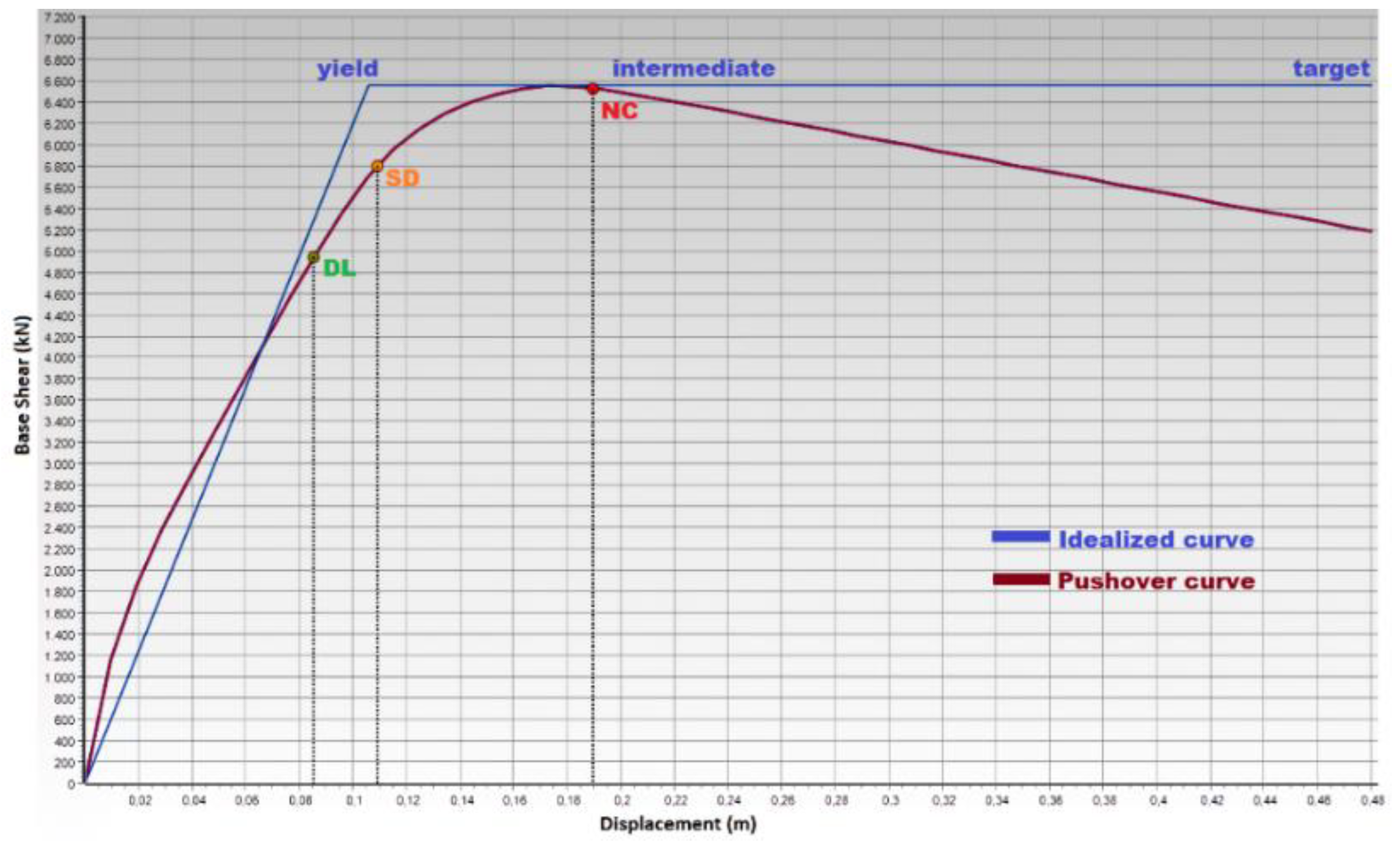
| Limit State | Description | Return Period (Year) | Probability of Exceedance (in 50 Years) |
|---|---|---|---|
| Damage Limitation (DL) | Only lightly damaged, damage to non-structural components is economically repairable | 225 | 0.20 |
| Significant Damage (SD) | Uneconomic to repair, significantly damaged, some residual strength and stiffness, non-structural components damaged, | 475 | 0.10 |
| Near collapse (NC) | Very low residual strength and stiffness, large permanent drift but still standing, heavily damaged | 2475 | 0.02 |
| Country | Number of Storey | Empirical Formula | Empirical Period (s) | Structural Analyses Period (s) | Description |
|---|---|---|---|---|---|
| Albania | 4 | T1 = (0.09.h)/b1/2 | 0.242 | 0.402 | h—the height of the structure (in meters). b—dimension of the building in parallel to the applied forces (in meters). |
| 6 | 0.362 | 0.597 | |||
| 8 | 0.483 | 0.796 | |||
| Bosnia and Herzegovina | 4 | T = Ct·H3/4 | 0.484 | 0.402 | Ct is 0.075 for RC frame structures and H is the total height of the building |
| 6 | 0.655 | 0.597 | |||
| 8 | 0.813 | 0.796 | |||
| Croatia | 4 | T = Ct·H3/4 | 0.484 | 0.402 | Ct is 0.075 for RC frame structures and H is the total building height |
| 6 | 0.655 | 0.597 | |||
| 8 | 0.813 | 0.796 | |||
| Iran | 4 | T = 0.05H0.9 | 0.468 | 0.402 | H is the total building height |
| 6 | 0.674 | 0.597 | |||
| 8 | 0.873 | 0.796 | |||
| Serbia | 4 | T = Ct·H3/4 | 0.484 | 0.402 | Ct is 0.075 for RC frame structures and H is the total building height |
| 6 | 0.655 | 0.597 | |||
| 8 | 0.813 | 0.796 | |||
| Türkiye | 4 | TPA = Ct. HN3/4 | 0.645 | 0.402 | HN is the building’s total height; Ct is the correction coefficient. Ct = 0.1 for RC building frames that built only beams and columns |
| 6 | 0.874 | 0.597 | |||
| 8 | 1.084 | 0.796 |
| No | Date | Location | Number of Storeys | Code Suggested | Measured | ||||
|---|---|---|---|---|---|---|---|---|---|
| DL (m) | SD (m) | NC (m) | DL (m) | SD (m) | NC (m) | ||||
| 1 | 26 November 2019 | Tirana | 4 | 0.115 | 0.157 | 0.295 | 0.035 | 0.045 | 0.088 |
| 6 | 0.203 | 0.262 | 0.459 | 0.071 | 0.092 | 0.164 | |||
| 8 | 0.272 | 0.348 | 0.604 | 0.099 | 0.128 | 0.221 | |||
| 2 | 26 November 2019 | Durres | 4 | 0.115 | 0.157 | 0.295 | 0.039 | 0.049 | 0.099 |
| 6 | 0.203 | 0.262 | 0.459 | 0.078 | 0.101 | 0.179 | |||
| 8 | 0.272 | 0.348 | 0.604 | 0.109 | 0.139 | 0.242 | |||
| 3 | 21 September 2019 | Tirana | 4 | 0.135 | 0.182 | 0.338 | 0.058 | 0.082 | 0.164 |
| 6 | 0.231 | 0.298 | 0.521 | 0.119 | 0.155 | 0.272 | |||
| 8 | 0.308 | 0.395 | 0.685 | 0.163 | 0.209 | 0.362 | |||
| 4 | 9 January 1998 | Tirana | 4 | 0.115 | 0.157 | 0.295 | 0.164 | 0.219 | 0.403 |
| 6 | 0.203 | 0.262 | 0.459 | 0.273 | 0.351 | 0.614 | |||
| 8 | 0.272 | 0.348 | 0.604 | 0.362 | 0.465 | 0.805 | |||
| 5 | 15 April 1979 | Shkoder | 4 | 0.115 | 0.157 | 0.295 | 0.193 | 0.257 | 0.468 |
| 6 | 0.203 | 0.262 | 0.459 | 0.314 | 0.405 | 0.707 | |||
| 8 | 0.272 | 0.348 | 0.604 | 0.416 | 0.534 | 0.926 | |||
| No | Date | Location | Number of Storeys | Suggested | Measured | ||||
|---|---|---|---|---|---|---|---|---|---|
| DL (m) | SD (m) | NC (m) | DL (m) | SD (m) | NC (m) | ||||
| 1 | 1969 | Bosnia and Herzegovina | 4 | 0.055 | 0.076 | 0.154 | 0.111 | 0.151 | 0.284 |
| 6 | 0.112 | 0.146 | 0.257 | 0.196 | 0.253 | 0.443 | |||
| 8 | 0.154 | 0.197 | 0.342 | 0.263 | 0.337 | 0.584 | |||
| 2 | 1962 | Bosnia and Herzegovina | 4 | 0.055 | 0.076 | 0.154 | 0.145 | 0.194 | 0.360 |
| 6 | 0.112 | 0.146 | 0.257 | 0.245 | 0.316 | 0.552 | |||
| 8 | 0.154 | 0.197 | 0.342 | 0.326 | 0.418 | 0.725 | |||
| 3 | 1981 | Bosnia and Herzegovina | 4 | 0.055 | 0.076 | 0.154 | 0.179 | 0.237 | 0.436 |
| 6 | 0.112 | 0.146 | 0.257 | 0.293 | 0.378 | 0.661 | |||
| 8 | 0.154 | 0.197 | 0.342 | 0.389 | 0.499 | 0.866 | |||
| 4 | 1969 | Bosnia and Herzegovina | 4 | 0.058 | 0.082 | 0.164 | 0.003 | 0.004 | 0.007 |
| 6 | 0.119 | 0.155 | 0.272 | 0.006 | 0.008 | 0.014 | |||
| 8 | 0.163 | 0.209 | 0.362 | 0.009 | 0.012 | 0.020 | |||
| 5 | 2019 | Bosnia and Herzegovina | 4 | 0.096 | 0.132 | 0.251 | 0.013 | 0.016 | 0.029 |
| 6 | 0.175 | 0.226 | 0.397 | 0.026 | 0.033 | 0.058 | |||
| 8 | 0.235 | 0.302 | 0.524 | 0.036 | 0.046 | 0.081 | |||
| No | Date | Location | Number of Storeys | Suggested | Measured | ||||
|---|---|---|---|---|---|---|---|---|---|
| DL (m) | SD (m) | NC (m) | DL (m) | SD (m) | NC (m) | ||||
| 1 | 2020 | Petrinja | 4 | 0.105 | 0.144 | 0.272 | 0.013 | 0.016 | 0.029 |
| 6 | 0.188 | 0.243 | 0.426 | 0.026 | 0.033 | 0.058 | |||
| 8 | 0.253 | 0.324 | 0.562 | 0.036 | 0.046 | 0.081 | |||
| 2 | 1990 | Kraljev Vrh | 4 | 0.095 | 0.131 | 0.250 | 0.019 | 0.025 | 0.043 |
| 6 | 0.174 | 0.225 | 0.395 | 0.039 | 0.050 | 0.087 | |||
| 8 | 0.234 | 0.301 | 0.522 | 0.054 | 0.070 | 0.121 | |||
| 3 | 1979 | Montenegro | 4 | 0.112 | 0.160 | 0.300 | 0.026 | 0.033 | 0.057 |
| 6 | 0.206 | 0.266 | 0.467 | 0.052 | 0.067 | 0.118 | |||
| 8 | 0.276 | 0.352 | 0.614 | 0.072 | 0.093 | 0.161 | |||
| 4 | 1979 | Montenegro | 4 | 0.104 | 0.142 | 0.269 | 0.013 | 0.016 | 0.029 |
| 6 | 0.186 | 0.241 | 0.422 | 0.026 | 0.033 | 0.058 | |||
| 8 | 0.250 | 0.321 | 0.556 | 0.036 | 0.046 | 0.081 | |||
| 5 | 1978 | Imotsk | 4 | 0.104 | 0.142 | 0.269 | 0.010 | 0.012 | 0.021 |
| 6 | 0.186 | 0.241 | 0.422 | 0.019 | 0.025 | 0.043 | |||
| 8 | 0.250 | 0.321 | 0.556 | 0.027 | 0.035 | 0.060 | |||
| No | Date | Location | Number of Storeys | Suggested | Measured | ||||
|---|---|---|---|---|---|---|---|---|---|
| DL (m) | SD (m) | NC (m) | DL (m) | SD (m) | NC (m) | ||||
| 1 | 2010 | Gruža | 4 | 0.067 | 0.094 | 0.186 | 0.019 | 0.025 | 0.043 |
| 6 | 0.133 | 0.173 | 0.304 | 0.039 | 0.050 | 0.087 | |||
| 8 | 0.181 | 0.232 | 0.403 | 0.054 | 0.070 | 0.121 | |||
| 2 | 2010 | Novi Pazar | 4 | 0.067 | 0.094 | 0.186 | 0.003 | 0.004 | 0.007 |
| 6 | 0.133 | 0.173 | 0.304 | 0.006 | 0.008 | 0.014 | |||
| 8 | 0.181 | 0.232 | 0.403 | 0.009 | 0.012 | 0.020 | |||
| 3 | 2010 | Kokin Brod | 4 | 0.048 | 0.063 | 0.132 | 0.003 | 0.004 | 0.007 |
| 6 | 0.098 | 0.128 | 0.226 | 0.006 | 0.008 | 0.014 | |||
| 8 | 0.136 | 0.174 | 0.302 | 0.009 | 0.012 | 0.020 | |||
| 4 | 2010 | Žagubica | 4 | 0.048 | 0.063 | 0.132 | 0.003 | 0.004 | 0.007 |
| 6 | 0.098 | 0.128 | 0.226 | 0.006 | 0.008 | 0.014 | |||
| 8 | 0.136 | 0.174 | 0.302 | 0.009 | 0.012 | 0.020 | |||
| 5 | 1990 | Novi Pazar | 4 | 0.067 | 0.094 | 0.186 | 0.003 | 0.004 | 0.007 |
| 6 | 0.133 | 0.173 | 0.304 | 0.006 | 0.008 | 0.014 | |||
| 8 | 0.181 | 0.232 | 0.403 | 0.009 | 0.012 | 0.020 | |||
| No | Date | Location | Number of Storeys | TBEC-2018, Suggested | Measured | ||||
|---|---|---|---|---|---|---|---|---|---|
| DL (m) | SD (m) | NC (m) | DL (m) | SD (m) | NC (m) | ||||
| 1 | 23 Octorber 2011 | Van | 4 | 0.164 | 0.219 | 0.402 | 0.058 | 0.083 | 0.167 |
| 6 | 0.272 | 0.351 | 0.612 | 0.121 | 0.156 | 0.276 | |||
| 8 | 0.361 | 0.463 | 0.803 | 0.165 | 0.211 | 0.366 | |||
| 2 | 1 May 2003 | Bingöl | 4 | 0.278 | 0.365 | 0.656 | 0.218 | 0.289 | 0.524 |
| 6 | 0.435 | 0.560 | 0.975 | 0.350 | 0.451 | 0.786 | |||
| 8 | 0.573 | 0.735 | 1.275 | 0.463 | 0.594 | 1.029 | |||
| 3 | 12 November 1999 | Düzce | 4 | 0.256 | 0.337 | 0.607 | 0.371 | 0.484 | 0.862 |
| 6 | 0.404 | 0.520 | 0.906 | 0.568 | 0.730 | 1.270 | |||
| 8 | 0.532 | 0.683 | 1.184 | 0.745 | 0.956 | 1.657 | |||
| 4 | 13 March 1992 | Erzincan | 4 | 0.180 | 0.239 | 0.439 | 0.206 | 0.273 | 0.495 |
| 6 | 0.295 | 0.380 | 0.664 | 0.332 | 0.428 | 0.746 | |||
| 8 | 0.391 | 0.502 | 0.870 | 0.439 | 0.563 | 0.977 | |||
| 5 | 17 Augst 1999 | Kocaeli | 4 | 0.306 | 0.401 | 0.718 | 0.164 | 0.219 | 0.402 |
| 6 | 0.475 | 0.611 | 1.064 | 0.272 | 0.351 | 0.612 | |||
| 8 | 0.625 | 0.801 | 1.389 | 0.361 | 0.463 | 0.803 | |||
| No | Date | Location | Number of Storeys | IS-2800 (Suggested) | Measured | ||||
|---|---|---|---|---|---|---|---|---|---|
| DL (m) | SD (m) | NC (m) | DL (m) | SD (m) | NC (m) | ||||
| 1 | 1990 | Qazvin | 4 | 0.140 | 0.188 | 0.349 | 0.031 | 0.039 | 0.072 |
| 6 | 0.238 | 0.307 | 0.536 | 0.062 | 0.079 | 0.141 | |||
| 8 | 0.317 | 0.407 | 0.705 | 0.086 | 0.110 | 0.191 | |||
| 2 | 1990 | Rudsar | 4 | 0.140 | 0.188 | 0.349 | 0.028 | 0.035 | 0.062 |
| 6 | 0.238 | 0.307 | 0.536 | 0.056 | 0.072 | 0.127 | |||
| 8 | 0.317 | 0.407 | 0.705 | 0.078 | 0.100 | 0.173 | |||
| 3 | 1990 | Rudsar | 4 | 0.140 | 0.188 | 0.349 | 0.231 | 0.306 | 0.553 |
| 6 | 0.238 | 0.307 | 0.536 | 0.369 | 0.475 | 0.828 | |||
| 8 | 0.317 | 0.407 | 0.705 | 0.487 | 0.625 | 1.083 | |||
| 4 | 1978 | Tabas | 4 | 0.140 | 0.188 | 0.349 | 0.282 | 0.370 | 0.665 |
| 6 | 0.238 | 0.307 | 0.536 | 0.441 | 0.567 | 0.988 | |||
| 8 | 0.317 | 0.407 | 0.705 | 0.580 | 0.745 | 1.291 | |||
| 5 | 2003 | Bam | 4 | 0.115 | 0.157 | 0.294 | 0.442 | 0.576 | 1.022 |
| 6 | 0.203 | 0.262 | 0.459 | 0.670 | 0.861 | 1.498 | |||
| 8 | 0.272 | 0.348 | 0.604 | 0.878 | 1.127 | 1.953 | |||
| Ground-Type | Description of Stratigraphic Profile | Parameters | ||
|---|---|---|---|---|
| Vs,30 (m/s) | NSPT (Blows/30 cm) | Cu (kPa) | ||
| A | Rock or other rock-like geological formation, including at most 5 m of weaker material at the surface | >800 | --- | --- |
| D | Deposits of loose-to-medium cohesionless soil (with or without some soft cohesive layers), or of predominantly soft-to-firm cohesive soil. | <180 | <15 | <70 |
| Earthquake No | Country | Location | Number of Storeys | Suggested | Measured | ||||
|---|---|---|---|---|---|---|---|---|---|
| DL (m) | SD (m) | NC (m) | DL (m) | SD (m) | NC (m) | ||||
| 1 | Albania | Tirana | 4 | 0.054 | 0.070 | 0.121 | 0.020 | 0.025 | 0.044 |
| 2 | Durres | 4 | 0.054 | 0.070 | 0.121 | 0.022 | 0.028 | 0.048 | |
| 3 | Tirana | 4 | 0.061 | 0.079 | 0.137 | 0.033 | 0.042 | 0.072 | |
| 4 | Tirana | 4 | 0.054 | 0.070 | 0.121 | 0.072 | 0.093 | 0.161 | |
| 5 | Shkoder | 4 | 0.054 | 0.070 | 0.121 | 0.083 | 0.107 | 0.185 | |
| 1 | Bosnia and Herzegovina | Banja Luka, | 4 | 0.030 | 0.040 | 0.068 | 0.052 | 0.067 | 0.117 |
| 2 | Banja Luka | 4 | 0.030 | 0.040 | 0.068 | 0.065 | 0.083 | 0.145 | |
| 3 | Banja Luka, | 4 | 0.030 | 0.040 | 0.068 | 0.078 | 0.100 | 0.173 | |
| 4 | Montenegro | 4 | 0.033 | 0.042 | 0.072 | 0.002 | 0.002 | 0.004 | |
| 5 | Montenegro | 4 | 0.047 | 0.060 | 0.104 | 0.007 | 0.009 | 0.016 | |
| 1 | Croatia | Petrinja | 4 | 0.050 | 0.065 | 0.112 | 0.007 | 0.009 | 0.016 |
| 2 | Kraljev Vrh | 4 | 0.047 | 0.060 | 0.104 | 0.011 | 0.014 | 0.024 | |
| 3 | Montenegro | 4 | 0.055 | 0.071 | 0.123 | 0.014 | 0.019 | 0.032 | |
| 4 | Montenegro | 4 | 0.050 | 0.064 | 0.111 | 0.007 | 0.009 | 0.016 | |
| 5 | Imotsk | 4 | 0.050 | 0.064 | 0.111 | 0.005 | 0.007 | 0.012 | |
| 1 | Serbia | Gruža | 4 | 0.036 | 0.046 | 0.080 | 0.011 | 0.014 | 0.024 |
| 2 | Novi Pazar | 4 | 0.036 | 0.046 | 0.080 | 0.002 | 0.002 | 0.004 | |
| 3 | Kokin Brod | 4 | 0.027 | 0.035 | 0.060 | 0.002 | 0.002 | 0.004 | |
| 4 | Žagubica | 4 | 0.027 | 0.035 | 0.060 | 0.002 | 0.002 | 0.004 | |
| 5 | Novi Pazar | 4 | 0.036 | 0.046 | 0.080 | 0.002 | 0.002 | 0.004 | |
| 1 | Türkiye | Van | 4 | 0.072 | 0.092 | 0.160 | 0.033 | 0.042 | 0.073 |
| 2 | Bingöl | 4 | 0.114 | 0.147 | 0.254 | 0.092 | 0.118 | 0.205 | |
| 3 | Düzce | 4 | 0.106 | 0.136 | 0.236 | 0.149 | 0.191 | 0.331 | |
| 4 | Erzincan | 4 | 0.078 | 0.100 | 0.174 | 0.087 | 0.112 | 0.195 | |
| 5 | Kocaeli | 4 | 0.125 | 0.160 | 0.277 | 0.072 | 0.092 | 0.160 | |
| 1 | Iran | Qazvin | 4 | 0.063 | 0.081 | 0.141 | 0.023 | 0.030 | 0.052 |
| 2 | Rudsar | 4 | 0.063 | 0.081 | 0.141 | 0.016 | 0.020 | 0.035 | |
| 3 | Rudsar | 4 | 0.063 | 0.081 | 0.141 | 0.097 | 0.125 | 0.216 | |
| 4 | Tabas | 4 | 0.063 | 0.081 | 0.141 | 0.116 | 0.149 | 0.258 | |
| 5 | Bam | 4 | 0.054 | 0.070 | 0.121 | 0.175 | 0.225 | 0.390 | |
| Importance Class | Buildings |
|---|---|
| II | Ordinary buildings, not belonging to the other categories. |
| IV | Buildings whose integrity during earthquakes is of vital importancefor civil protection, e.g., hospitals, fire stations, power plants, etc |
| Earthquake No | Country | Location | Number of Storeys | Suggested | Measured | ||||
|---|---|---|---|---|---|---|---|---|---|
| DL (m) | SD (m) | NC (m) | DL (m) | SD (m) | NC (m) | ||||
| 1 | Albania | Tirana | 4 | 0.074 | 0.103 | 0.202 | 0.025 | 0.032 | 0.056 |
| 2 | Durres | 4 | 0.074 | 0.103 | 0.202 | 0.027 | 0.035 | 0.062 | |
| 3 | Tirana | 4 | 0.088 | 0.121 | 0.233 | 0.041 | 0.053 | 0.109 | |
| 4 | Tirana | 4 | 0.074 | 0.103 | 0.202 | 0.109 | 0.147 | 0.279 | |
| 5 | Shkoder | 4 | 0.074 | 0.103 | 0.202 | 0.129 | 0.175 | 0.326 | |
| 1 | Bosnia and Herzegovina | Banja Luka, | 4 | 0.039 | 0.05 | 0.101 | 0.07 | 0.099 | 0.194 |
| 2 | Banja Luka | 4 | 0.039 | 0.05 | 0.101 | 0.094 | 0.130 | 0.248 | |
| 3 | Banja Luka, | 4 | 0.039 | 0.05 | 0.101 | 0.119 | 0.161 | 0.302 | |
| 4 | Montenegro | 4 | 0.041 | 0.053 | 0.109 | 0.002 | 0.003 | 0.005 | |
| 5 | Montenegro | 4 | 0.06 | 0.085 | 0.171 | 0.009 | 0.011 | 0.02 | |
| 1 | Croatia | Petrinja | 4 | 0.066 | 0.094 | 0.185 | 0.009 | 0.011 | 0.02 |
| 2 | Kraljev Vrh | 4 | 0.059 | 0.085 | 0.170 | 0.014 | 0.018 | 0.031 | |
| 3 | Montenegro | 4 | 0.075 | 0.105 | 0.205 | 0.018 | 0.024 | 0.041 | |
| 4 | Montenegro | 4 | 0.065 | 0.093 | 0.183 | 0.009 | 0.011 | 0.02 | |
| 5 | Imotsk | 4 | 0.065 | 0.093 | 0.183 | 0.007 | 0.009 | 0.015 | |
| 1 | Serbia | Gruža | 4 | 0.046 | 0.059 | 0.124 | 0.014 | 0.018 | 0.031 |
| 2 | Novi Pazar | 4 | 0.046 | 0.059 | 0.124 | 0.002 | 0.003 | 0.005 | |
| 3 | Kokin Brod | 4 | 0.034 | 0.044 | 0.085 | 0.002 | 0.003 | 0.005 | |
| 4 | Žagubica | 4 | 0.034 | 0.044 | 0.085 | 0.002 | 0.003 | 0.005 | |
| 5 | Novi Pazar | 4 | 0.046 | 0.059 | 0.124 | 0.002 | 0.003 | 0.005 | |
| 1 | Türkiye | Van | 4 | 0.108 | 0.147 | 0.278 | 0.042 | 0.054 | 0.11 |
| 2 | Bingöl | 4 | 0.190 | 0.252 | 0.46 | 0.147 | 0.198 | 0.365 | |
| 3 | Düzce | 4 | 0.174 | 0.232 | 0.425 | 0.256 | 0.337 | 0.607 | |
| 4 | Erzincan | 4 | 0.12 | 0.162 | 0.304 | 0.138 | 0.186 | 0.345 | |
| 5 | Kocaeli | 4 | 0.21 | 0.278 | 0.504 | 0.108 | 0.147 | 0.278 | |
| 1 | Iran | Qazvin | 4 | 0.091 | 0.126 | 0.240 | 0.030 | 0.038 | 0.700 |
| 2 | Rudsar | 4 | 0.091 | 0.126 | 0.240 | 0.020 | 0.025 | 0.044 | |
| 3 | Rudsar | 4 | 0.091 | 0.126 | 0.24 | 0.157 | 0.21 | 0.386 | |
| 4 | Tabas | 4 | 0.091 | 0.126 | 0.240 | 0.192 | 0.256 | 0.466 | |
| 5 | Bam | 4 | 0.074 | 0.103 | 0.202 | 0.307 | 0.403 | 0.721 | |
| Earthquake No | Country | Location | Number of Storeys | Suggested | Measured | ||||
|---|---|---|---|---|---|---|---|---|---|
| DL (m) | SD (m) | NC (m) | DL (m) | SD (m) | NC (m) | ||||
| 1 | Albania | Tirana | 4 | 0.124 | 0.167 | 0.311 | 0.038 | 0.049 | 0.096 |
| 2 | Durres | 4 | 0.124 | 0.167 | 0.311 | 0.042 | 0.054 | 0.107 | |
| 3 | Tirana | 4 | 0.144 | 0.193 | 0.356 | 0.063 | 0.089 | 0.175 | |
| 4 | Tirana | 4 | 0.124 | 0.167 | 0.311 | 0.175 | 0.232 | 0.424 | |
| 5 | Shkoder | 4 | 0.124 | 0.167 | 0.311 | 0.205 | 0.272 | 0.492 | |
| 1 | Bosnia and Herzegovina | Banja Luka, | 4 | 0.059 | 0.082 | 0.164 | 0.119 | 0.161 | 0.3 |
| 2 | Banja Luka | 4 | 0.059 | 0.082 | 0.164 | 0.154 | 0.206 | 0.379 | |
| 3 | Banja Luka, | 4 | 0.059 | 0.082 | 0.164 | 0.19 | 0.252 | 0.458 | |
| 4 | Montenegro | 4 | 0.063 | 0.088 | 0.175 | 0.004 | 0.005 | 0.008 | |
| 5 | Montenegro | 4 | 0.104 | 0.141 | 0.266 | 0.014 | 0.018 | 0.031 | |
| 1 | Croatia | Petrinja | 4 | 0.113 | 0.153 | 0.287 | 0.014 | 0.018 | 0.031 |
| 2 | Kraljev Vrh | 4 | 0.103 | 0.14 | 0.264 | 0.021 | 0.027 | 0.047 | |
| 3 | Montenegro | 4 | 0.126 | 0.17 | 0.316 | 0.028 | 0.036 | 0.062 | |
| 4 | Montenegro | 4 | 0.112 | 0.151 | 0.284 | 0.014 | 0.018 | 0.031 | |
| 5 | Imotsk | 4 | 0.112 | 0.151 | 0.284 | 0.01 | 0.013 | 0.023 | |
| 1 | Serbia | Gruža | 4 | 0.073 | 0.102 | 0.198 | 0.021 | 0.027 | 0.047 |
| 2 | Novi Pazar | 4 | 0.073 | 0.102 | 0.198 | 0.004 | 0.005 | 0.008 | |
| 3 | Kokin Brod | 4 | 0.052 | 0.069 | 0.141 | 0.004 | 0.005 | 0.008 | |
| 4 | Žagubica | 4 | 0.052 | 0.069 | 0.141 | 0.004 | 0.005 | 0.008 | |
| 5 | Novi Pazar | 4 | 0.073 | 0.102 | 0.198 | 0.004 | 0.005 | 0.008 | |
| 1 | Turkey | Van | 4 | 0.174 | 0.232 | 0.423 | 0.064 | 0.09 | 0.177 |
| 2 | Bingöl | 4 | 0.293 | 0.385 | 0.688 | 0.231 | 0.305 | 0.55 | |
| 3 | Düzce | 4 | 0.271 | 0.355 | 0.637 | 0.39 | 0.509 | 0.903 | |
| 4 | Erzincan | 4 | 0.191 | 0.253 | 0.46 | 0.218 | 0.288 | 0.52 | |
| 5 | Kocaeli | 4 | 0.322 | 0.422 | 0.752 | 0.174 | 0.232 | 0.423 | |
| 1 | Iran | Qazvin | 4 | 0.149 | 0.2 | 0.367 | 0.045 | 0.058 | 0.118 |
| 2 | Rudsar | 4 | 0.149 | 0.2 | 0.367 | 0.03 | 0.039 | 0.069 | |
| 3 | Rudsar | 4 | 0.149 | 0.2 | 0.367 | 0.245 | 0.323 | 0.58 | |
| 4 | Tabas | 4 | 0.149 | 0.2 | 0.367 | 0.297 | 0.389 | 0.697 | |
| 5 | Bam | 4 | 0.124 | 0.167 | 0.311 | 0.465 | 0.605 | 1.069 | |
| Material Type | <1945 | 1945–1960 | 1961–1980 | 1981–1990 | 1991–1995 |
|---|---|---|---|---|---|
| RC and masonry structures | 37416 | 63870 | 141170 | 102198 | 43324 |
| Prefabricated concrete | - | - | 4601 | 5993 | 4575 |
| Wooden | 462 | - | 1821 | 1273 | 743 |
| Other types | 2560 | 3393 | 7105 | 6263 | 4238 |
Publisher’s Note: MDPI stays neutral with regard to jurisdictional claims in published maps and institutional affiliations. |
© 2022 by the authors. Licensee MDPI, Basel, Switzerland. This article is an open access article distributed under the terms and conditions of the Creative Commons Attribution (CC BY) license (https://creativecommons.org/licenses/by/4.0/).
Share and Cite
Işık, E.; Hadzima-Nyarko, M.; Bilgin, H.; Ademović, N.; Büyüksaraç, A.; Harirchian, E.; Bulajić, B.; Özmen, H.B.; Aghakouchaki Hosseini, S.E. A Comparative Study of the Effects of Earthquakes in Different Countries on Target Displacement in Mid-Rise Regular RC Structures. Appl. Sci. 2022, 12, 12495. https://doi.org/10.3390/app122312495
Işık E, Hadzima-Nyarko M, Bilgin H, Ademović N, Büyüksaraç A, Harirchian E, Bulajić B, Özmen HB, Aghakouchaki Hosseini SE. A Comparative Study of the Effects of Earthquakes in Different Countries on Target Displacement in Mid-Rise Regular RC Structures. Applied Sciences. 2022; 12(23):12495. https://doi.org/10.3390/app122312495
Chicago/Turabian StyleIşık, Ercan, Marijana Hadzima-Nyarko, Hüseyin Bilgin, Naida Ademović, Aydın Büyüksaraç, Ehsan Harirchian, Borko Bulajić, Hayri Baytan Özmen, and Seyed Ehsan Aghakouchaki Hosseini. 2022. "A Comparative Study of the Effects of Earthquakes in Different Countries on Target Displacement in Mid-Rise Regular RC Structures" Applied Sciences 12, no. 23: 12495. https://doi.org/10.3390/app122312495