
The Urban CoCreation Lab—An Integrated Platform for Remote and Simultaneous Collaborative Urban Planning and Design through Web-Based Desktop 3D Modeling, Head-Mounted Virtual Reality and Mobile Augmented Reality: Prototyping a Minimum Viable Product and Developing Specifications for a Minimum Marketable Product


Abstract
:1. Introduction
1.1. Challenges of Stakeholder Engagement in Urban Planning and Design
1.1.1. Representation of the Built Environment
1.1.2. Facilitating Remote Two-Way Communication
1.1.3. Knowledge Gap and Aim
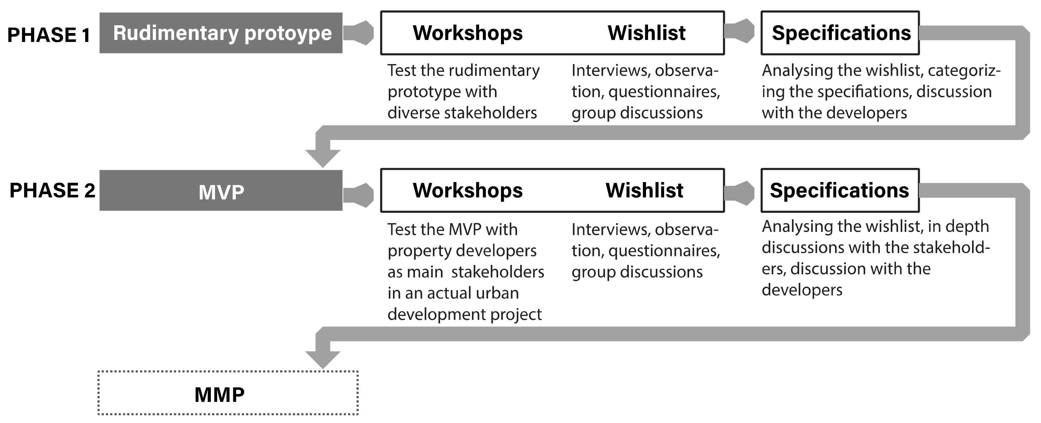
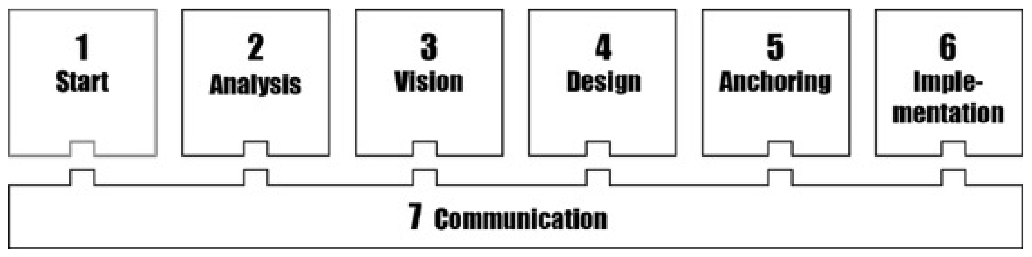
2. Methods
2.1. Phase 1: Developing a Minimum Viable Product
2.1.1. Case Gibraltarvallen
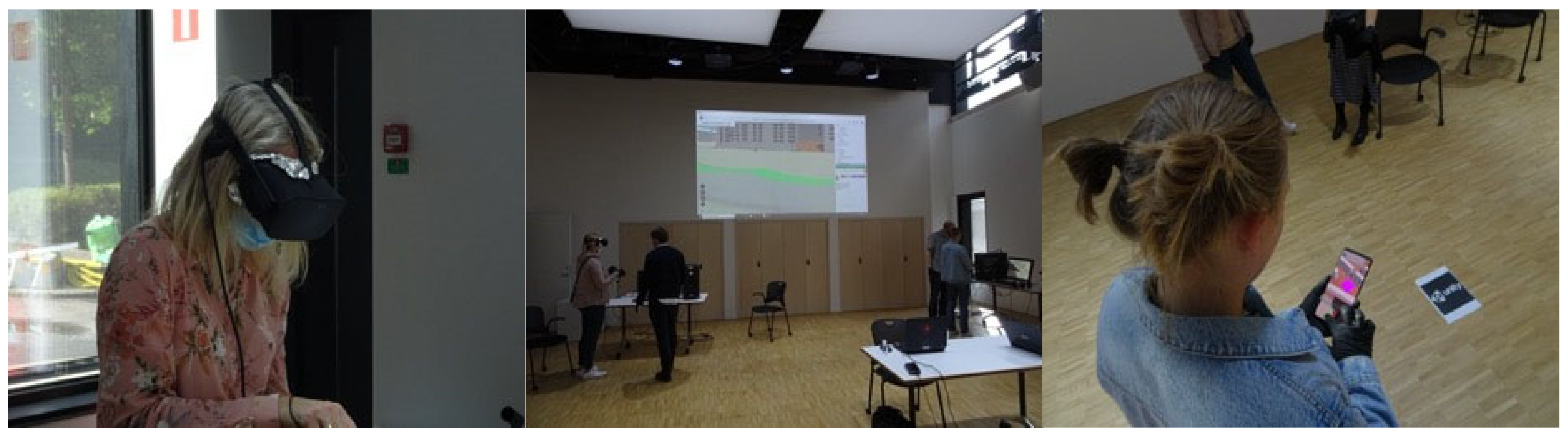
2.1.2. First Prototype Trials and Gathering Stakeholder Wishes
2.1.3. Developing Specifications and Shaping a Minimum Viable Product
2.2. Phase 2: Developing a Minimum Marketable Product (MMP)
2.2.1. Case Medicinarberget
2.2.2. Trials of Minimum Viable Product and Gathering Additional Stakeholder Wishes
3. Results
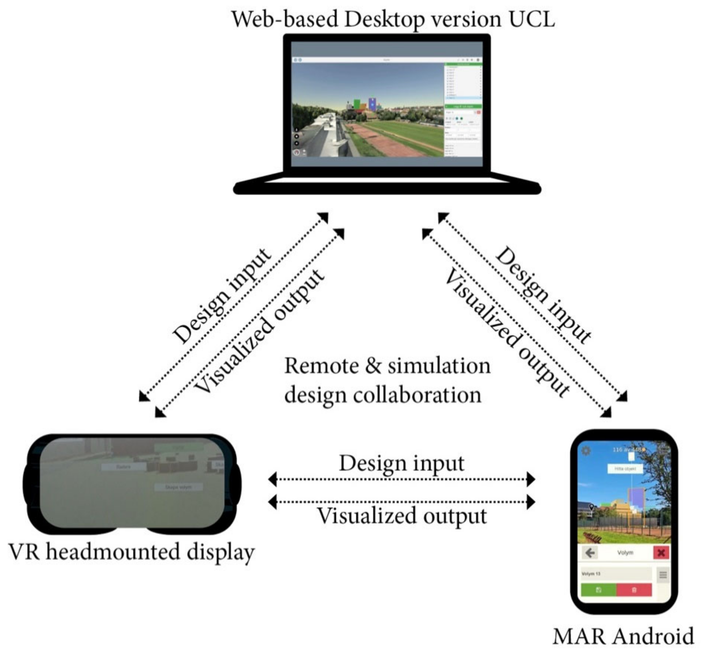
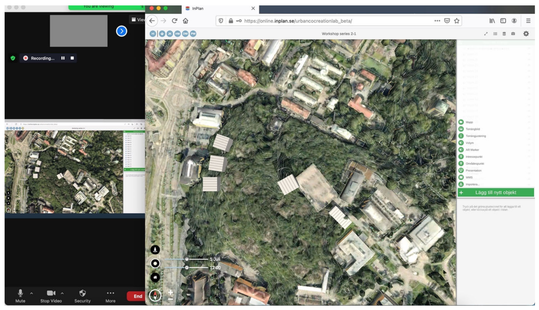
3.1. The First Basic Platform Rudimentary Prototype
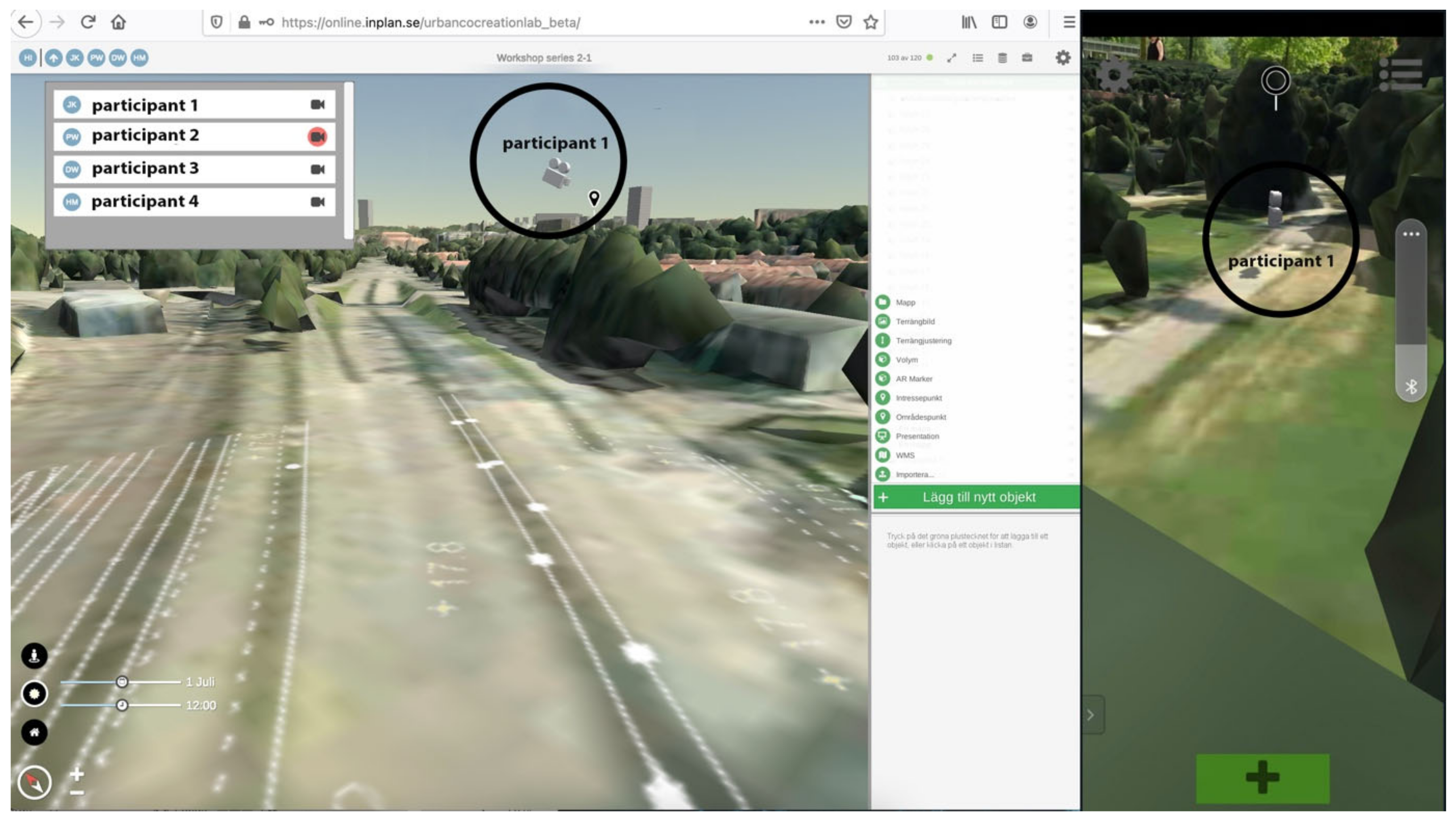
- Synchronization of MAR, web-based desktop 3D modeling stations and head-mounted VR for remote and simultaneous 3D-modeling collaboration;
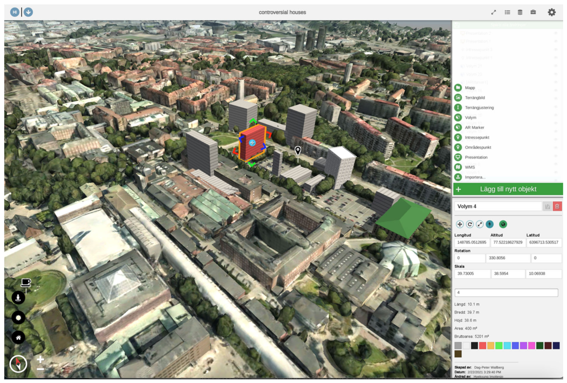
- 3D modeling in MAR, web-based desktop stations and head-mounted VR by placing a cube as a building volume which can be modified by rotating, scaling, moving, changing colors and deleting;
- Modification of all 3D volumes in MAR, web-based desktop stations and head-mounted VR by all participants, including those created by other participants;
- All participants can view the others as simple avatars;
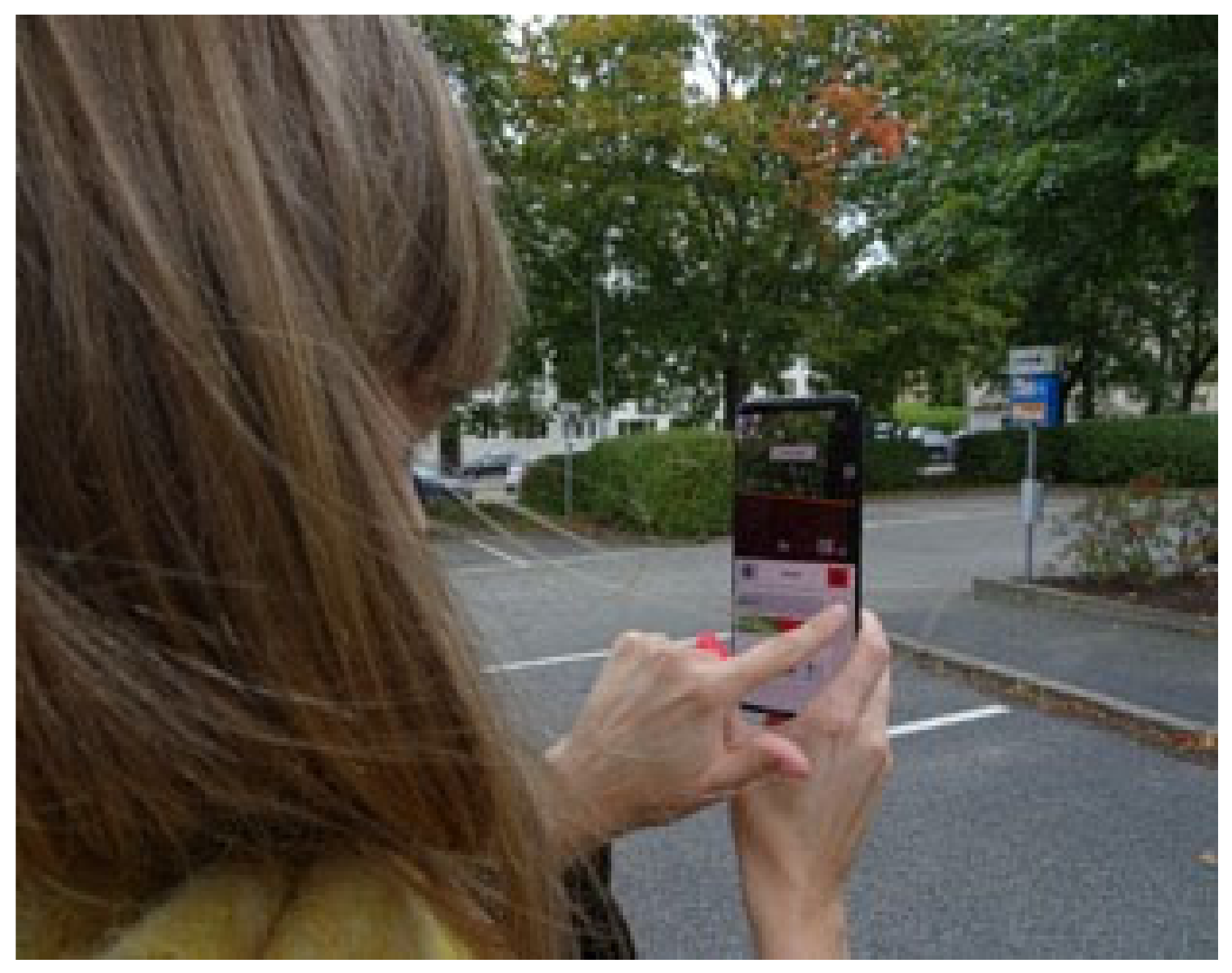
- MAR using marker-based localization;
- MAR can be viewed as scaled and in scale 1:1;
- Participants can navigate in the virtual space and return to a pre-set starting point;
- Participants can place a pin in an area of interest and leave a comment, image or sound.
3.2. Stakeholder Wishlists, Platform Specifications and Implementation
3.3. Implementation into a Minimum Viable Product
3.4. Elaborated Specifications as a Foundation for a Minimum Marketable Product
4. Discussion
4.1. Visualizing the Built Environment
4.2. Layman Participation and Modeling Methods
4.3. Remote Collaboration
4.4. Simulation of Design Impact
5. Conclusions
5.1. Limitations
5.2. Scope for the Next Phases
Supplementary Materials
Author Contributions
Funding
Conflicts of Interest
References
- Statens Offentliga Utredningar. Femton Hinder för Hållbar Stadsutveckling Delegationen för Hållbara Städer; Statens Offentliga Utredningar: Stockholm, Sweden, 2012.
- United Nations. Habitat III: New Urban Agenda; United Nations: San Francisco, CA, USA, 2016. [Google Scholar]
- UN Habitat. Mixed Reality for Public Participation in Urban and Public Space Design Towards a New Way of Crowdsourcing more Inclusive Smart Cities; Nairobi GPO: Kenya, Africa, 2019. [Google Scholar]
- Irvin, R.A.; Stansbury, J. Citizen Participation in Decision Making: Is It Worth the Effort? Public Adm. Rev. 2004, 64, 55–65. [Google Scholar] [CrossRef]
- Martinez, C.; Olander, S. Stakeholder Participation for Sustainable Property Development. Procedia Econ. Financ. 2015, 21, 57–63. [Google Scholar] [CrossRef] [Green Version]
- Innes, J.E.; Booher, D.E. Planning with Complexity: An Introduction to Collaborative Rationality for Public Policy; Milton Park: Abingdon, UK; Routledge: New York, NY, USA, 2010. [Google Scholar]
- Batty, M. Cities, complexity, and emergent order. Growth 2011, 21, 28–30. [Google Scholar]
- Batty, M.; Marshall, S. The Origins of Complexity Theory in Cities and Planning. In Complexity Theories of Cities Have Come of Age; Springer: Berlin/Heidelberg, Germany, 2012; pp. 21–45. [Google Scholar] [CrossRef]
- Portugali, J. Theories of Cities Have Come of Age: An Overview with Implications to Urban Planning and Design. In Complexity Theories of Cities: Implications to Urban Planning; Portugali, J., Meyer, H., Stolk, E., Tan, E., Eds.; Springer: Berlin/Heidelberg, Germany, 2012; pp. 221–244. Available online: http://link.springer.com/10.1007/978-3-642-24544-2 (accessed on 5 January 2022).
- Soma, K.; Dijkshoorn-Dekker, M.W.C.; Polman, N.B.P. Stakeholder contributions through transitions towards urban sustainability. Sustain. Cities Soc. 2018, 37, 438–450. [Google Scholar] [CrossRef]
- Fagerholm, N.; Käyhkö, N.; Ndumbaro, F.; Khamis, M. Community stakeholders’ knowledge in landscape assessments—Mapping indicators for landscape services. Ecol. Indic. 2012, 18, 421–433. [Google Scholar] [CrossRef]
- IPCC. Summary for Policymakers. In: Global Warming of 1.5 °C. An IPCC Special Report on the Impacts of Global Warming of 1.5 °C above Pre-Industrial Levels and Related Global Greenhouse Gas Emission Pathways, in the Context of Strengthening the Global Response to. 2018. Available online: https://www.ipcc.ch/sr15/chapter/spm/ (accessed on 5 January 2022).
- Bovari, E.; Giraud, G.; Mc Isaac, F. Coping with Collapse: A Stock-Flow Consistent Monetary Macrodynamics of Global Warming. Ecol. Econ. 2018, 147, 383–398. [Google Scholar] [CrossRef]
- Sharifi, A.; Khavarian-Garmsir, A.R. The COVID-19 pandemic: Impacts on cities and major lessons for urban planning, design, and management. Sci. Total Environ. 2020, 749, 142391. [Google Scholar] [CrossRef]
- United Nations. Transforming Our World: The 2030 Agenda for Sustainable Development. A/RES/70/1. 2015. Available online: https://www.refworld.org/docid/57b6e3e44.html (accessed on 5 January 2022).
- Holland, J.H. Complex Adaptive Systems and Spontaneous Emergence. In Complexity and Industrial Clusters; Curzio, A.Q., Fortis, M., Eds.; Physica-Verlag HD: Heidelberg, Germany, 2002; pp. 25–34. [Google Scholar] [CrossRef]
- Innes, J.E.; Booher, D.E. Consensus Building and Complex Adaptive Systems. J. Am. Plan. Assoc. 1999, 65, 412–423. [Google Scholar] [CrossRef]
- Bates-Brkljac, N. Assessing perceived credibility of traditional and computer generated architectural representations. Des. Stud. 2009, 30, 415–437. [Google Scholar] [CrossRef]
- Canel, M.J.; Luomo, V.A. Public Sector Communication: Closing Gaps Between Citizens and Public Organizations; Wiley Blackwell: Hoboken, NJ, USA, 2018. [Google Scholar]
- Billger, M.; Thuvander, L.; Wästberg, B.S. In search of visualization challenges: The development and implementation of visualization tools for supporting dialogue in urban planning processes. Environ. Plan. B Urban Anal. City Sci. 2017, 44, 1012–1035. [Google Scholar] [CrossRef]
- Wilson, A.; Tewdwr-Jones, M.; Comber, R. Urban planning, public participation and digital technology: App development as a method of generating citizen involvement in local planning processes. Environ. Plan. B: Urban Anal. City Sci. 2019, 46, 286–302. [Google Scholar] [CrossRef]
- Chantziaras, G.; Triantafyllidis, A.; Papaprodromou, A.; Chatzikonstantinou, I.; Giakoumis, D.; Tsakiris, A.; Votis, K.; Tzovaras, D. An Augmented Reality-Based Remote Collaboration Platform for Worker Assistance. In Lecture Notes in Computer Science (Including Subseries Lecture Notes in Artificial Intelligence and Lecture Notes in Bioinformatics), 12667 LNCS; Springer: Cham, Switzerland, 2021; pp. 404–416. [Google Scholar] [CrossRef]
- Maiti, M.; Priyaadharshini, M.; Vinayaga Sundaram, B. Augmented Reality in Virtual Classroom for Higher Education During COVID-19 Pandemic. In Intelligent Computing; Arai, K., Ed.; Springer International Publishing: Berlin/Heidelberg, Germany, 2021; pp. 399–418. [Google Scholar]
- Culshaw, M.G.; Nathanail, C.P.; Leeks, G.J.L.; Alker, S.; Bridge, D.; Duffy, T.; Fowler, D.; Packman, J.C.; Swetnam, R.; Wadsworth, R.; et al. The role of web-based environmental information in urban planning-the environmental information system for planners. Sci. Total Environ. 2006, 360, 233–245. [Google Scholar] [CrossRef]
- Stoiciu, A. The role of e-governance in bridging the digital divide. UN Chron. 2011, 48, 37–39. [Google Scholar] [CrossRef]
- Schindler, M.; Dionisio, M.R.; Kingham, S. A multi-level perspective on a spatial data ecosystem: Needs and challenges among urban planning stakeholders in New Zealand. Int. J. Spat. Data Infrastruct. Res. 2018, 13, 223–252. [Google Scholar] [CrossRef]
- Smith, P.D.; McDonough, M.H. Beyond public participation: Fairness in natural resource decision making. Soc. Nat. Resour. 2001, 14, 239–249. [Google Scholar] [CrossRef]
- Wergles, N.; Muhar, A. The role of computer visualization in the communication of urban design-A comparison of viewer responses to visualizations versus on-site visits. Landsc. Urban Plan. 2009, 91, 171–182. [Google Scholar] [CrossRef]
- Isaacs, J.P.; Gilmour, D.J.; Blackwood, D.J.; Falconer, R.E.; von Stechow, C. Immersive and Non immersive 3D virtual cit: Decision support tool for urban sustainability. J. Inf. Technol. Constr. 2011, 16, 149–159. Available online: http://www.itcon.org/2011/10 (accessed on 5 January 2022).
- Piga, B.; Morello, E. Environmental design studies on perception and simulation: An urban design approach. Ambiances. Environ. Sensib. Archit. Espace Urbain 2015, 1, 1–24. Available online: http://ambiances.revues.org/647 (accessed on 5 January 2022). [CrossRef] [Green Version]
- Chowdhury, S.; Schnabel, M.A. Communication and Participation in Virtual Environments: Towards a parametric participatory urban design decision-making platform. In Engaging Architectural Science: Meeting the Challenges of Higher Density: 52nd International Conference of the Architectural Science Association; Rajagopalan, P., Andamon, M.M., Eds.; The Architectural Science Association and RMIT University: Melbourne, Australia, 2018; pp. 727–734. [Google Scholar]
- Keil, J.; Edler, D.; Schmitt, T.; Dickmann, F. Creating Immersive Virtual Environments Based on Open Geospatial Data and Game Engines. KN—J. Cartogr. Geogr. Inf. 2021, 71, 53–65. [Google Scholar] [CrossRef]
- Schnabel, M.A.; Kvan, T. Design, Communication & Collaboration in Immersive Virtual Environments. Int. J. Des. Comput. 2002, 4, 472–478. Available online: http://papers.cumincad.org/data/works/att/bc52.content.00289.pdf (accessed on 5 January 2022).
- Santana, J.M.; Wendel, J.; Trujillo, A.; Suárez, J.P.; Simons, A.; Koch, A. Multimodal Location Based Services---Semantic 3D City Data as Virtual and Augmented Reality. In Progress in Location-Based Services 2016; Gartner, G., Huang, H., Eds.; Springer International Publishing: Berlin/Heidelberg, Germany, 2017; pp. 329–353. [Google Scholar]
- Faliu, B.; Siarheyeva, A.; Lou, R.; Merienne, F. Design and prototyping of an interactive virtual environment to foster citizen participation and creativity in urban design. In Proceedings of the 27th International Conference on Information Systems Development: Designing Digitalization, ISD 2018, Lund, Sweden, 22–24 August 2018; pp. 1–13. [Google Scholar]
- Pereira, G.V.; Parycek, P.; Falco, E.; Kleinhans, R.; Chun, S.A.; Adam, N.R.; Noveck, B. Smart governance in the context of smart cities: A literature review. Inf. Polity Int. J. Gov. Democr. Inf. Age 2018, 23, 143–162. [Google Scholar] [CrossRef] [Green Version]
- Imottesjo, H.; Kain, J.-H. The Urban CoBuilder—A mobile augmented reality tool for crowd-sourced simulation of emergent urban development patterns: Requirements, prototyping and assessment. Comput. Environ. Urban Syst. 2018, 71, 120–130. [Google Scholar] [CrossRef]
- Chowdhury, S.; Schnabel, M.A. Laypeople’s Collaborative Immersive Virtual Reality Design Discourse in Neighborhood Design. Front. Robot. AI 2019, 6, 97. [Google Scholar] [CrossRef] [Green Version]
- Waizenegger, L.; McKenna, B.; Cai, W.; Bendz, T. An affordance perspective of team collaboration and enforced working from home during COVID-19. Eur. J. Inf. Syst. 2020, 29, 429–442. [Google Scholar] [CrossRef]
- Shi, Y.; Du, J.; Lavy, S.; Zhao, D. A Multiuser Shared Virtual Environment for Facility Management. Procedia Eng. 2016, 145, 120–127. [Google Scholar] [CrossRef] [Green Version]
- Allen, M.; Regenbrecht, H.; Abbott, M. Smartphone augmented reality for public participation in urban planning. In Proceedings of the 23rd Australian Computer-Human Interaction Conference, Canberra, Australia, 28 November–2 December 2011; pp. 11–20. [Google Scholar]
- Florea, C.; Alavesa, P.; Arhippainen, L.; Pouke, M.; Huang, W.; Haukipuro, L.; Väinämö, S.; Niemelä, A.; Orduña, M.C.; Pakanen, M.A.; et al. Extending a User Involvement Tool with Virtual and Augmented Reality. In Proceedings of the 2019 IEEE Conference on Virtual Reality and 3D User Interfaces (VR), Osaka, Japan, 27 March 2019; pp. 925–926. [Google Scholar] [CrossRef]
- Piga, B.; Boffi, M.; Rainisio, N.; Stancato, G.; Ceravolo, P.; Tavares, G. An interdisciplinary approach to urban planning via Augmented/Virtual Reality and Process Mining. In C3places.Using ICT for Co-Creation of Inclusive Public Space; Edições Universitárias Lusófonas: Lisbon, Portugal, 2021; pp. 53–54. 3p. [Google Scholar]
- Onyimbi, J.R.; Koeva, M.; Flacke, J. Public Participation Using 3D Web-Based City Models: Opportunities for E-Participation in Kisumu, Kenya. ISPRS Int. J. Geo-Inf. 2018, 7, 454. [Google Scholar] [CrossRef] [Green Version]
- Van Leeuwen, J.P.; Hermans, K.; Jylhä, A.; Quanjer, A.J.; Nijman, H. Effectiveness of virtual reality in participatory urban planning. In Proceedings of the ACM International Conference Proceeding Series, Shanghai, China, 4–6 May 2018; pp. 128–136. [Google Scholar] [CrossRef] [Green Version]
- Pejic, P.; Lakicevic, M.; Krasic, S.; Predrag, S. Application of Augmented and Virtual Reality in Residential Complex Presentation, Case Study: Energoprojekt Sunnyville. J. Ind. Des. Eng. Graph. 2017, 12, 127–132. [Google Scholar]
- Delgado, J.M.; Oyedele, L.; Demian, P.; Beach, T. A research agenda for augmented and virtual reality in architecture, engineering and construction. Adv. Eng. Inform. 2020, 45, 101122. [Google Scholar] [CrossRef]
- Al-Kodmany, K. Using visualization techniques for enhancing public participation in planning and design: Process, implementation, and evaluation. Landsc. Urban Plan. 1999, 45, 37–45. [Google Scholar] [CrossRef]
- Bugs, G.; Granell, C.; Fonts, O.; Huerta, J.; Painho, M. An assessment of public participation GIS and web 2.0 technologies in urban planning practice in Canela, Brazil. Cities 2010, 27, 172–181. [Google Scholar] [CrossRef]
- Wilson, A.; Tewdwr-Jones, M. Let’s draw and talk about urban change: Deploying digital technology to encourage citizen participation in urban planning. Environ. Plan. B: Urban Anal. City Sci. 2019, 47, 1588–1604. [Google Scholar] [CrossRef]
- Saßmannshausen, S.M.; Radtke, J.; Bohn, N.; Hussein, H.; Randall, D.; Pipek, V. Citizen-Centered Design in Urban Planning: How Augmented Reality can be used in Citizen Participation Processes. In Proceedings of the DIS ’21: Designing Interactive Systems Conference, New York, NY, USA, 28 June–2 July 2021; pp. 250–265. [Google Scholar]
- Gill, L.; Lange, E. Getting virtual 3D landscapes out of the lab. Comput. Environ. Urban Syst. 2015, 54, 356–362. [Google Scholar] [CrossRef] [Green Version]
- Du, J.; Zou, Z.; Shi, Y.; Zhao, D. Zero latency: Real-time synchronization of BIM data in virtual reality for collaborative decision-making. Autom. Constr. 2018, 85, 51–64. [Google Scholar] [CrossRef]
- Shin, S.; Jeong, S.; Lee, J.; Hong, S.W.; Jung, S. Pre-Occupancy Evaluation based on user behavior prediction in 3D virtual simulation. Autom. Constr. 2017, 74, 55–65. [Google Scholar] [CrossRef]
- Slator, B.M.; Borchert, O.; Brandt, L.; Chaput, H.; Erickson, K.; Groesbeck, G.; Halvorson, J.; Hawley, J.; Hokanson, G.; Reetz, D.; et al. From dungeons to classrooms: The evolution of MUDs as learning environments. Stud. Comput. Intell. 2007, 62, 119–159. [Google Scholar] [CrossRef]
- Afrooz, A.; Ding, L.; Pettit, C. An immersive 3D virtual environment to support collaborative learning and teaching. In Lecture Notes in Geoinformation and Cartography; Geertman, S., Zhan, Q., Allan, A., Pettit, C., Eds.; Springer: Cham, Switzerland, 2019; pp. 267–282. [Google Scholar] [CrossRef]
- Dede, C.; Nelson, B.; Ketelhut, D.J.; Clarke, J.; Bowman, C. Design-based research strategies for studying situated learning in a multi-user virtual environment. In Paper Presented at the International Conference on Learning Sciences; Taylor & Francis e-Library: Mahweh, NJ, USA, 2004. [Google Scholar]
- Hong, S.W.; El Antably, A.; Kalay, Y.E. Architectural design creativity in Multi-User Virtual Environment: A comparative analysis between remote collaboration media. Environ. Plan. B Urban Anal. City Sci. 2019, 46, 826–844. [Google Scholar] [CrossRef]
- Hong, S.W.; Jeong, Y.; Kalay, Y.E.; Jung, S.; Lee, J. Enablers and barriers of the multi-user virtual environment for exploratory creativity in architectural design collaboration. CoDesign 2016, 12, 151–170. [Google Scholar] [CrossRef]
- Schnabel, M.A.; Kvan, T. Spatial Understanding in Immersive Virtual Environments. Int. J. Archit. Comput. 2003, 1, 435–448. [Google Scholar] [CrossRef]
- Twitchen, C.; Adams, D. Using web technology to increase levels of public participation in planning. In Town Planning Review; Liverpool University Press: Liverpool, UK, 2012; Volume 83, pp. vii–xiv. [Google Scholar] [CrossRef]
- Hunter, M.; Soro, A.; Brown, R. Enhancing Urban Conversations for Smarter Cities: Augmented Reality as an Enabler of Digital Civic Participation. Interact. Des. and Archit. (S) 2021, 48, 75–99. [Google Scholar]
- OED, Oxford English Dictionary. Minimum Viable Product. 2021. Available online: https://www.oed.com/view/Entry/118854#eid1320080550 (accessed on 5 January 2022).
- Beaudouin-Lafon, M.; Mackay, W. Prototyping Tools and Techniques. In The Human-Computer Interaction Handbook: Fundamentals, Evolving Technologies and Emerging Applications; L. Erlbaum Associates Inc.: New York, NY, USA, 2002; pp. 1006–1031. [Google Scholar]
- Steven, D.P.; Kate Heddleston, K.; Klemmer, S.R. The Efficacy of Prototyping under Time Constraints. In C and C 2009—Proceedings of the 2009 ACM SIGCHI Conference on Creativity and Cognition; Association for Computing Machinery: New York, NY, USA, 2009; pp. 165–174. [Google Scholar] [CrossRef]
- Christie, E.J.; Jensen, D.D.; Buckley, R.T.; Menefee, D.A.; Ziegler, K.K.; Wood, K.L.; Crawford, R.H. Prototyping Strategies: Literature Review and Identification of Critical Variables. In Proceedings of the ASEE Annual Conference and Exposition, Conference Proceedings, San Antonio, TX, USA, 10 June 2012. [Google Scholar]
- Sukhoo, A.; Barnard, A.; Eloff, M.M.; Van der Poll, J.A. Towards a framework for evaluating strengths and weaknesses of software projects. In Proceedings of the 2004 PMSA International Conference, Johannesburg, South Africa, 10–12 May 2004; pp. 193–199. [Google Scholar]
- Chirra, S.; Reza, H. A Survey on Software Cost Estimation Techniques. J. Softw. Eng. Appl. 2019, 12, 226–248. [Google Scholar] [CrossRef] [Green Version]
- Chubachi, Y.; Kaiya, H. Generalizing and composing goals and objects in a scenario together for requirements analysis. In Proceedings of the 2017 8th International Conference on Information, Intelligence, Systems Applications (IISA), Larnaca, Cyprus, 27–30 August 2017; pp. 1–6. [Google Scholar] [CrossRef]
- Imottesjo, H.; Thuvander, L.; Billger, M.; Wallberg, P.; Bodell, G.; Kain, J.-H.; Nielsen, S.A. Iterative Prototyping of Urban CoBuilder: Tracking Methods and User Interface of an Outdoor Mobile Augmented Reality Tool for Co-Designing. Multimodal Technol. Interact. 2020, 4, 26. [Google Scholar] [CrossRef]
- Atvis. In Plan Beskrivning. 3 November 2021. Available online: http://www.inplan.se/beskrivning.html (accessed on 5 January 2022).
- Litwin, U.; Pluta, M.; Mitka, B. Improving the Perception in Urban Planning by 3D Modeling and 3D Visualization. In Land Ownership and Land Use Development:The Integration of Past, Present, and Future in Spatial Planning and Land Management Policies; Hepperle, E., Dixon-Gough, R., Mansberger, R., Paulsson, J., Hernik, J., Kalbro, T., Eds.; vdf Hochschulverlag AG an der ETH: Zürich, Switzerland, 2017. [Google Scholar]
- Nysetvold, T.T.; Teng, C.-C. Collaboration tools for multi-user CAD. In Proceedings of the 2013 IEEE 17th International Conference on Computer Supported Cooperative Work in Design (CSCWD), Whistler, BC, Canada, 27–29 June 2013; pp. 241–245. [Google Scholar]
- French, D.J.; Stone, B.; Nysetvold, T.T.; Hepworth, A.; Red, W.E. Collaborative Design Principles From Minecraft With Applications to Multi-User Computer-Aided Design. J. Comput. Inf. Sci. Eng. 2016, 16, 021006. [Google Scholar] [CrossRef]
- Stahre Wästberg, B.; Billger, M.; Adelfio, M.A. User-Based Look at Visualization Tools for Environmental Data and Suggestions for Improvement—An Inventory among City Planners in Gothenburg. Sustainability 2020, 12, 2882. [Google Scholar] [CrossRef] [Green Version]
- Hollberg, A.; Kiss, B.; Röck, M.; Soust-Verdaguer, B.; Wiberg, A.H.; Lasvaux, S.; Galimshina, A.; Habert, G. Review of Visualising LCA Results in the Design Process of Buildings. Build. Environ. 2021, 190, 107530. [Google Scholar] [CrossRef]
- Meex, E.; Hollberg, A.; Knapen, E.; Hildebrand, L.; Verbeeck, G. Requirements for applying LCA-based environmental impact assessment tools in the early stages of building design. Build. Environ. 2018, 133, 228–236. [Google Scholar] [CrossRef]


| Theme 1: Visualization | |||
| Sub-Theme 1-1: Layers | |||
| Wishes | Specifications | Implementations | Functions |
| Turn on and off different 3D volumes and models. | Different volumes, models, projects, and information should be placed in layers and turned on and off to enable and disable showing. | A folder structure where users can put models in different folders which can be turned on or off. | Place objects: folders. |
| Visualize different types of information, e.g., underground and water drainage. | |||
| Add layers with more detailed visuals for specific areas. | Make it possible to highlight certain focus areas. | Highlighting focus objects and areas was not implemented for the MVP. However, more detailed visuals for focus areas can be added, e.g., by inserting 3D drone images. | |
| Clearly separate newly designed and yet-unbuilt projects from existing areas. | |||
| Sub-Theme 1-2: Scale | |||
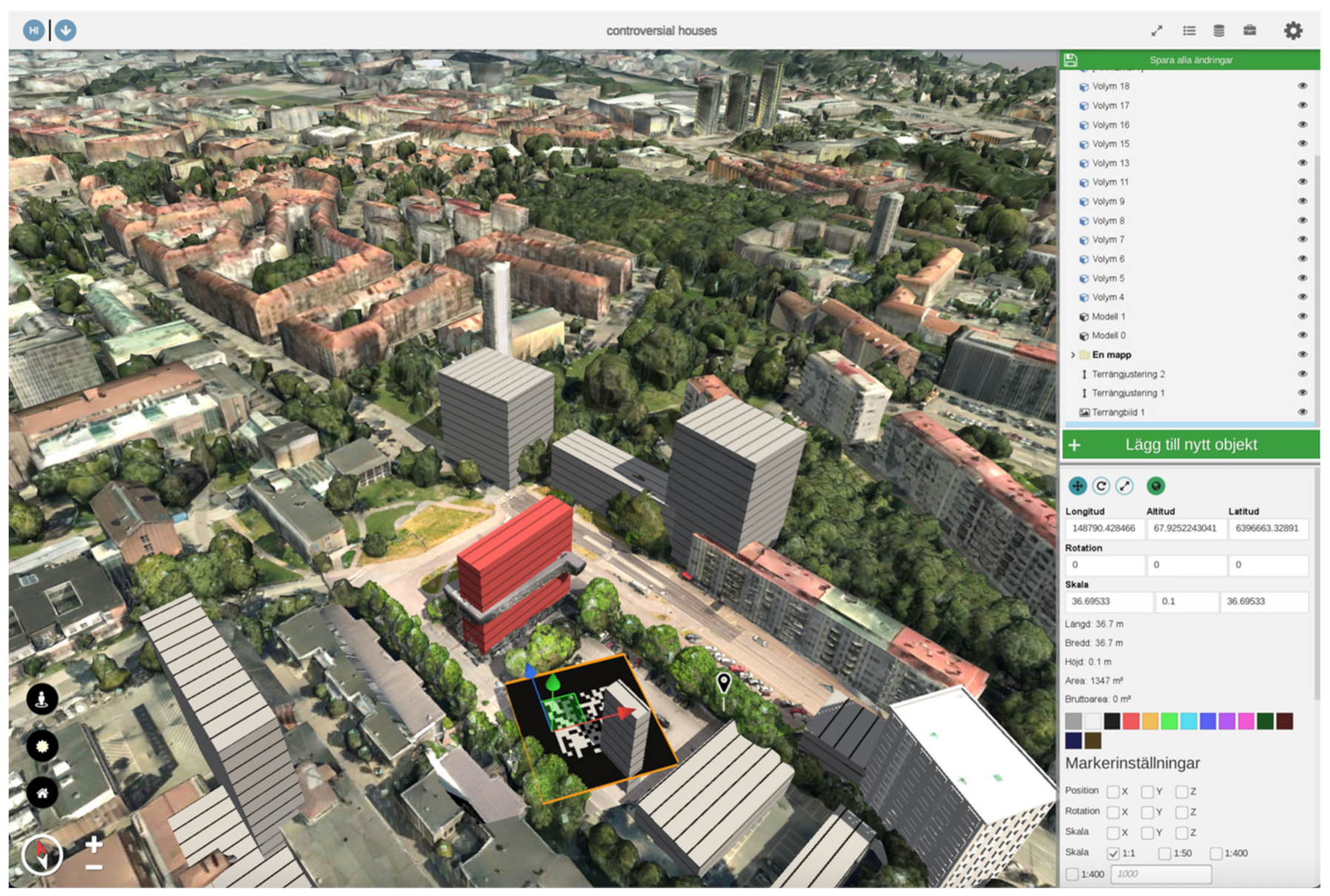
| References to understand scale of the building volumes. | Number and height of floors should be indicated. | The facade texture has lines indicating floors. Users can set the height of the floor. | Place objects: Volumes. |
| Indicate how tall a building is. | |||
| References to understand human scale and terrain. | Reference objects such as a scaled human should be included. | This was not implemented for the MVP. | |
| Sub-Theme 1-3: Information | |||
| Tag buildings with information, such as owners, size, floors and functions. | Tag the building volumes with building information: functions of the building, owner (who created it), floor area and number of floors. Create ability to add comments to buildings. | Floor areas, number of floors and heights are indicated. | Place objects: Volume. |
| Link text/images to objects. | User can tag an area or object with a pin with information using text, images and sound. | Place objects: Interest area and interest object. | |
| Sub-Theme 1-4: Detailing | |||
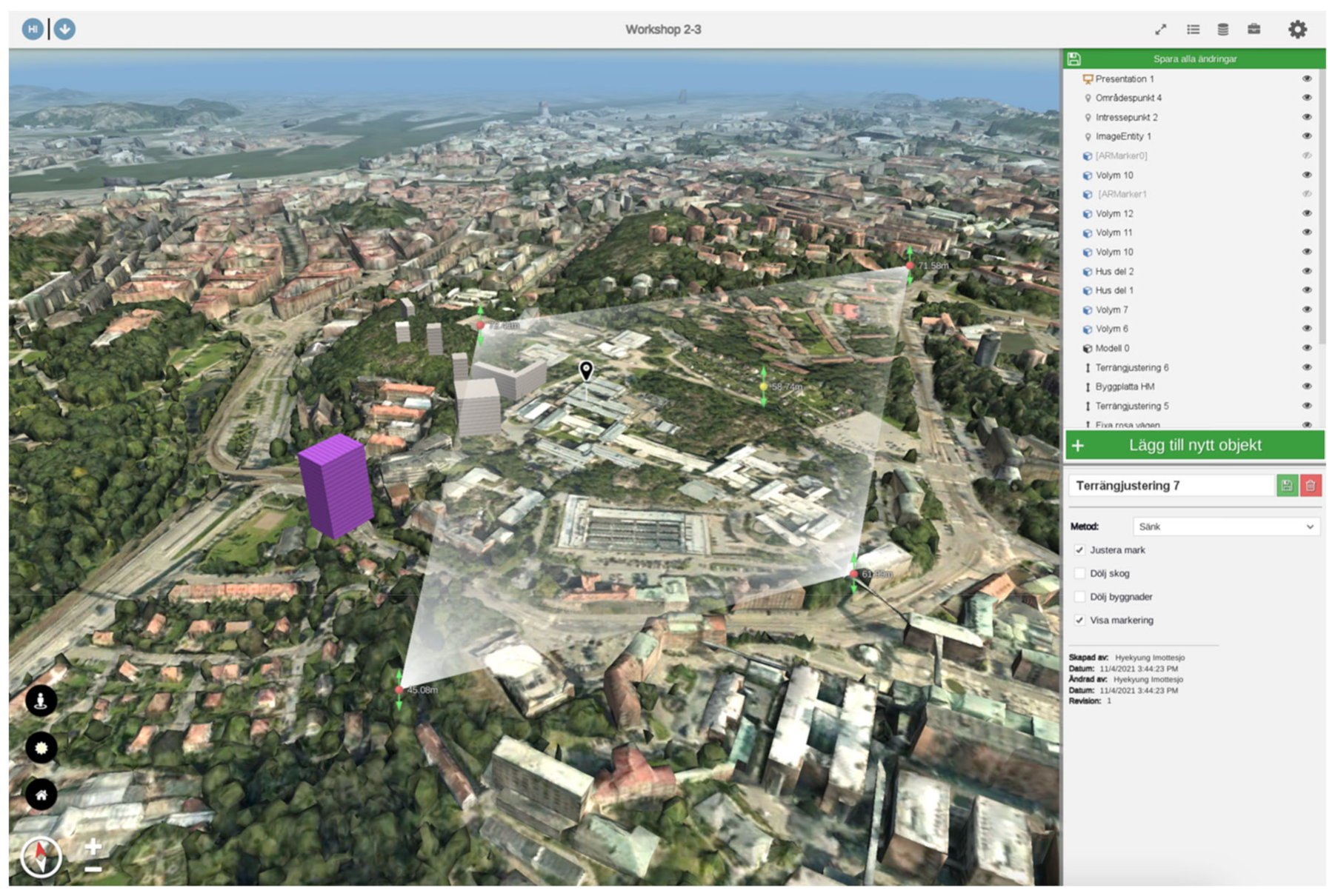
| Better details for the ground and terrain, such as site boundaries and road edges. | Site boundaries/edges of the streets and roads need to be clearly indicated. | Users can import e.g., a detailed plan as an image file overlay. This image can be modified by rotating, scaling and moving. | Terrain drawing: Import image. |
| User can draw lines directly on the terrain in different line weight and color. | Terrain drawing | ||
| More details in the model, such as facade, doors, windows and roofs. | This was not turned into a specification for the MVP but was still considered important. | ||
| Sub-Theme 1-5: Orientating and locating | |||
| 2D map/terrain image for better orientating. | A 2D map view should be enabled. | Users can choose a layer of plans, maps or satellite images to be overlaid. | Map layers |
| Teleporting to a saved view-point. | Teleporting to a saved view should be enabled. | Users can quickly move back to a saved location using a home button. | A home button |
| Theme 2: Modeling | |||
| Sub-Theme 2-1: Methods | |||
| Wishes | Specifications | Implementations | Functions |
| Set width and height of objects when designing 3D volumes. | Building the 3D model by adding the number of floors should be possible. | Building by adding floors was the most mentioned building method in the wishlist. Even though this has not been implemented, adding a facade texture indicating floor lines and being able to modify the height of each floor was implemented. | Place objects: volumes. |
| Set floor number and height when designing 3D volumes. | |||
| Building volumes by adding floors. | |||
| Draw polylines and extrude into volumes. | These were not made into specifications for the MVP. | ||
| Build volume by drawing walls. | |||
| Sub-Theme 2-2: Viewports | |||
| Street-view function. | Easily switch mode of view between street-view and bird’s-eye view. | This was not implemented for VR and MAR but in the web-based desktop version it is possible to navigate in both street-view and bird’s-eye view through a view mode switch button. | A view mode switch button. |
| Switch between 3D immersion and bird’s-eye view. | |||
| Move down to ground and zoom. | |||
| Sub-Theme 2-3: Functionalities | |||
| Save different iterations, histories, geometries and specific views. | Create a model and save it and go back to a previous version. | Building volumes can be saved as presentation viewpoints or recorded views and can be turned on and off for showing. | Place an object: Presentation. |
| User defined names and colors for building volumes. | Users can define names and colors for the building volumes. | Users can modify the color of the building volumes and name them. | Place an object: Volume. |
| Undo/regret and restore. | This was not turned into a specification for the MVP. | ||
| Sub-Theme 2-4: User Interface | |||
| More intuitive and simpler steps to make building volumes. | More simplistic input for basic functions. | User interface was generally improved. | |
| More graphics, less text. | |||
| Theme 3: Remote simultaneous collaboration | |||
| Sub-Theme 3-1: Remote collaboration | |||
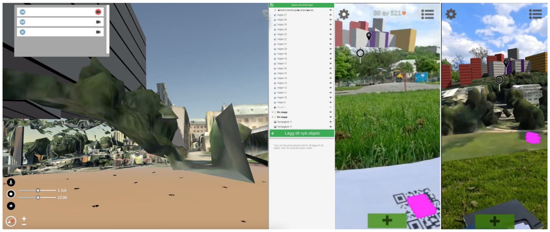
| Guided tour function with preset tracks with limitation to deviate from paths or use of arrows to guide. | Showing other users focus areas by guiding, limited views and possibility to teleport them. | This was implemented as a presentation mode. The users can also adopt the point of view of each other by simply clicking on the other participant’s name. Another feature is the adoption of an avatar as a camera, which shows the location of other users as well as where the users are looking. AR markers can be placed by the users for communication across the devices. | Place an object: Presentation. |
| Adopt another user’s view. | |||
| Place an object: AR marker. | |||
| Add possibilities for feedback and comments. | Create ability to add comments to buildings. | User can tag an area or object with a pin containing information by using text, images, and sound. | Place objects: Interest area and interest object. |
| Highlight focus areas. | This was not turned into a specification for the MVP. | ||
| Sub-Theme 3-2: Compatibility with other platforms | |||
| Compatibility with other tools which architects use, such as Autodesk, 3D-modeling software and Esri. | Import and export models from/to other popular architectural tools. | Sketchup models in compressed FBX format and image files in PNG format can be imported. | Place an object: Import. |
| Connect with Google maps and Sketchup. | Terrain drawing: Import image. | ||
| Sub-Theme 3-3: Isolation and synchronization | |||
| Define level of users for different functionalities, such as only commenting, only viewing and modifying designs. | Users’ levels should be defined. | Guest access with only viewing. | |
| Locking and isolating feature for input from individual users so that other users are not allowed to modify. | Possibilities to lock a volume or model should be investigated. However, as the purpose of this tool is collaboration and gathering valuable input from diverse stakeholders, this needs careful consideration how it can best be done. At this stage, this was not turned into a specification for the MVP. | ||
| Ownership of the building volumes and designs. | This was not turned into a specification for the MVP. | ||
| Theme 4: Simulation | |||
| Sub-Theme 4-1: Design consequences | |||
| Sun and shadow simulations. | Impact of shadows based on the design should be simulated. | Sun and shadows can be simulated based on the time and date and the location of the site. | Tools: Sun and shadow simulation. |
| Visualization of environmental qualities, such as air qualities and noise levels. | This was not turned into a specification for the MVP but was still considered relevant. | ||
| Sub-Theme 4-2: Preset scenarios | |||
| Building heights limitations. | Preset scenarios should be simulated. | This was not implemented as a separate function. However, different scenarios can be placed in folders to enable and disable viewing. | Place an object: Folder. |
| Building orientations. | |||
| Functions | What Does It Do? | |
|---|---|---|
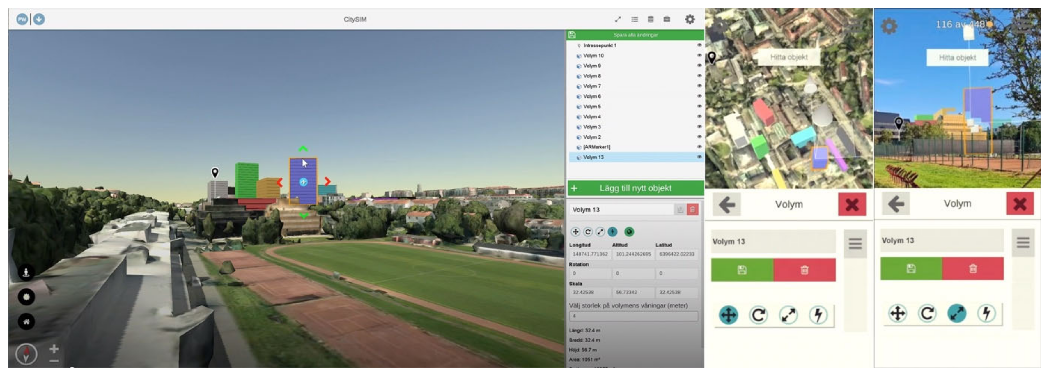
| Place objects | Volumes | A 3D cube is placed that can be moved, scaled and rotated. The dimension of the cube can be defined in an object property window. |
| Pins | A pin with a variety of shapes can be placed. Information or comments can be attached by texts and photos. | |
| Terrain image | 2D lines can be drawn directly over the terrain. The color of the lines can be selected. An image file can be imported and overlaid on the terrain. The image file can be moved, scaled and rotated. | |
| AR markers | AR markers that can be moved, scaled and rotated are placed on the terrain. The scale of 3D projection can be determined in the object property window. The size of the physical marker can also be determined. | |
| Import | A 3D mesh model can be imported. The model can be moved, scaled, and rotated. | |
| Folders | Folders can be created and building volumes and 3D models can be placed in those. Folders can be turned on and off. | |
| Terrain adjustment | A part of the terrain can be defined by drawing a polygon over the location for adjustment. The nodes of the polygon can be elevated or lowered to adjust the elevation terrain. | |
| Sun/shade simulation | Sun and shade can be simulated for the design by manipulating the time of day and year. | |
| Adopt the point of view of other participants | Participants can adopt the point of view of other participants by choosing an avatar (camera icon with participant’s name) to follow, including street-view and bird’s-eye view. | |
| Navigation | One can navigate the scene in bird’s-eye view and street-view. |
| Theme 1: Visualization | |||
| Scale | |||
| Issues and Wishes | Discussion Points | Discussion Summary | Specifications for MMP |
| Sense of scale is still an issue. | Are floor lines not enough in which way? | Floor lines and being able to incorporate the ground detail plan increases the perception of scale. | Not necessary to change. |
| What else could be done for a better perception of scale? | Participants should be able to place urban objects, such as trees, cars, buses and benches, to understand the space better. | 1. Add library of urban objects, such as vegetation, vehicles, people and benches. | |
| Information | |||
| Building functions need to be indicated. | Does the function for changing the color of the building work for this? | Stakeholders need to be able to standardize colors for each building function. | 2. Allow user-defined standardization of colors for building functions. |
| How would you indicate building functions? | Colors on different floors would increase the level of detail. | 3. Allow for applying colors on different floors for mixed function buildings. | |
| More maps with different data should be available. | What additional types of maps and data would be available? | Availability of maps with data depends on the municipalities and what type of data they have. | |
| Create one’s own map layer. | What type of map layers would need to be created? | Heatmaps with various information, roads, entrances to buildings and meeting places. | 4. Make it easy to create a map layer with user-defined information. |
| Detailing | |||
| Better graphics are needed for a walkthrough. | The graphic quality depends on the 3D materials we can acquire for the project. What would be the minimum acceptable quality? | The 3D material provided by the municipality is not good enough to be useful for formal work processes. Project-based 3D environment mapping (e.g., through drones) is required. | 5. Possibility for project-based 3D environment mapping is required. |
| Different textures for the buildings, including transparency, might be needed. Same color building volumes make a wall-like effect viewed from a long distance. | Which textures would be good to include? Concrete, bricks, glass or any other? Should the users be able to upload textures to be used? | Textures would be great, but it is not necessary for basic usability at this stage. | |
| Is transparency and reflection important? | Transparency reflection is not necessary at this stage. | ||
| Orientating and locating | |||
| Drop anchor points to go back to or send people to a specific location. | Is the “home button” not enough? | Users should be able to define locations to summon other participants. | 6. Users should be able to easily mark and unmark locations where to bring other users. |
| Eye-level remains on the original terrain level when walking on lowered ground level using a terrain adjustment function. | This is due to the type of 3D model provided by the municipality. | Distinguishing the vegetation and ground in the mesh model is required for better terrain modification and control of eye level. | 7. Possibility for project-based 3D environment mapping is required. |
| Theme 2: Modeling | |||
| Methods | |||
| Roads and 2D drawings from terrain adjustment function are drawn on top of vegetation. | This is due to the type of 3D model provided by the municipality. | ||
| Making building volumes by drawing polygons and extruding. | If polygons can be drawn and extruded for modeling, what would be good to have? Dimension, angles? | Simply choosing corners on the map and extruding would work. | 8. Making 3D volumes by choosing corners and extruding should be possible. |
| 2D drawing should enable vector lines that the users can manipulate using control points. | 9. 2D lines should be vector lines with control points. | ||
| More forms and shapes are needed. | What type of shapes are necessary? | Placing simple symbols such as arrows and circles. | 10. Include library of symbols, such as arrows and circles. |
| Functionalities | |||
| Copy and paste function is necessary. | Any other essential functions? | Copy and paste of volumes. | 11. Allow for copy and paste of 3D volumes. |
| Copy and paste of terrain adjustment parameters. | 12. Allow for copy and paste of input parameters, such as terrain adjustment and building volumes. | ||
| User interface | |||
| User interface | The text on the screen should be zoomed in and out. | Bug needs to be fixed. | |
| Theme 3: Remote simultaneous collaboration | |||
| Remote communication | |||
| Avatars should look different. | How much detail is needed for the avatar’s look? Would color-coding work? | Avatars can be as they are with names of the participants indicated. | |
| Turning off a specific folder view with building volumes should be shared with other users to hide some of the building volumes for everyone. | Synchronizing the view for everyone? | Presentation mode where one can synchronize the views for everyone is required. | 13. Add presentation mode including a function to synchronize views for everyone. |
| Laser points to show where one person is pointing. | It is difficult to point at a specific object. How best can it be done? | A pointer, arrow or highlighting of a specific object should be available. | 14. Add indication for what is being pointed at. |
| Sessions should be recorded. | 15. Add a session recording function. | ||
| Compatibility with other platforms | |||
| Importing PNG is problematic. | Which formats should be imported? | Starting with PNG of diverse sizes. | 16. Files of diverse sizes should be imported. |
| Importing Sketchup model is problematic. | 17. General improvement is required for importing and placing files. | ||
| Road maps need to be imported more easily. | |||
| Isolation and synchronizing | |||
| Feature to lock and unlock the volumes for everyone to prevent accidental removal of buildings. | Users should be able to lock the volumes. | 18. Add function allowing users to lock volumes. | |
| A visitor account to limit the number of people who can participate actively for a higher quality of discussion. | This goes against the aim of the collaborative platform. However, this could be achieved already by inviting relevant stakeholders and using guest logging in. | ||
| Theme 4: Simulation | |||
| Design consequences | |||
| Information related to sustainability, energy use and density could be simulated based on the design. | Can we create a specific list of relevant simulations? | Not necessary for this use. | |
| Preset scenarios | |||
| Calculating the number of offices or apartments per building with pre-programmed values. | Can we create a specific list? | Not necessary at this stage. | |
Publisher’s Note: MDPI stays neutral with regard to jurisdictional claims in published maps and institutional affiliations. |
© 2022 by the authors. Licensee MDPI, Basel, Switzerland. This article is an open access article distributed under the terms and conditions of the Creative Commons Attribution (CC BY) license (https://creativecommons.org/licenses/by/4.0/).
Share and Cite
Imottesjo, H.; Kain, J.-H. The Urban CoCreation Lab—An Integrated Platform for Remote and Simultaneous Collaborative Urban Planning and Design through Web-Based Desktop 3D Modeling, Head-Mounted Virtual Reality and Mobile Augmented Reality: Prototyping a Minimum Viable Product and Developing Specifications for a Minimum Marketable Product. Appl. Sci. 2022, 12, 797. https://doi.org/10.3390/app12020797
Imottesjo H, Kain J-H. The Urban CoCreation Lab—An Integrated Platform for Remote and Simultaneous Collaborative Urban Planning and Design through Web-Based Desktop 3D Modeling, Head-Mounted Virtual Reality and Mobile Augmented Reality: Prototyping a Minimum Viable Product and Developing Specifications for a Minimum Marketable Product. Applied Sciences. 2022; 12(2):797. https://doi.org/10.3390/app12020797
Chicago/Turabian StyleImottesjo, Hyekyung, and Jaan-Henrik Kain. 2022. "The Urban CoCreation Lab—An Integrated Platform for Remote and Simultaneous Collaborative Urban Planning and Design through Web-Based Desktop 3D Modeling, Head-Mounted Virtual Reality and Mobile Augmented Reality: Prototyping a Minimum Viable Product and Developing Specifications for a Minimum Marketable Product" Applied Sciences 12, no. 2: 797. https://doi.org/10.3390/app12020797