Article

A Low-Cost Global Navigation Satellite System Positioning Accuracy Assessment Method for Agricultural Machinery

Faculty of Agrobiotechnical Sciences Osijek, Josip Juraj Strossmayer University of Osijek, Vladimira Preloga 1, 31000 Osijek, Croatia
*
Author to whom correspondence should be addressed.
Appl. Sci. 2022, 12(2), 693; https://doi.org/10.3390/app12020693
Submission received: 17 December 2021 / Revised: 4 January 2022 / Accepted: 9 January 2022 / Published: 11 January 2022
(This article belongs to the Special Issue Engineering of Smart Agriculture)

Abstract

:
The high-precision positioning and navigation of agricultural machinery represent a backbone for precision agriculture, while its worldwide implementation is in rapid growth. Previous studies improved low-cost global navigation satellite system (GNSS) hardware solutions and fused GNSS data with complementary sources, but there is still no affordable and flexible framework for positioning accuracy assessment of agricultural machinery. Such a low-cost method was proposed in this study, simulating the actual movement of the agricultural machinery during agrotechnical operations. Four of the most commonly used GNSS corrections in Croatia were evaluated in two repetitions: Croatian Positioning System (CROPOS), individual base station, Satellite-based Augmentation Systems (SBASs), and an absolute positioning method using a smartphone. CROPOS and base station produced the highest mean GNSS positioning accuracy of 2.4 and 2.9 cm, respectively, but both of these corrections produced lower accuracy than declared. All evaluated corrections produced significantly different median values in two repetitions, representing inconsistency of the positioning accuracy regarding field conditions. While the proposed method allowed flexible and effective application in the field, future studies will be directed towards the reduction of the operator’s subjective impact, mainly by implementing autosteering solutions in agricultural machinery.

1. Introduction

The advancement of positioning and navigation technology using global navigation satellite systems (GNSSs) ensures its growing use in both precision agriculture and conventional farming [1]. These systems improved multiple aspects of agricultural production since their inception, most notably regarding the accuracy of agrotechnical operations, enabled working hours under lower visibility conditions, as well as lower fatigue for the workers [2]. Moreover, it became a cornerstone of all agrotechnical operations in precision agriculture, allowing precise navigation and implementation of pre-made crop sowing, fertilization, and crop protection prescription maps [3]. With Global Positioning System (GPS) and GLONASS fully operational on a global scale, as well as Galileo and Beidou being at the high level of operability, the future of GNSS application in farming will gradually offer more capabilities in the future [4].
The relative observation techniques using GNSS, most notably real-time-kinematic (RTK), provide corrections up to 2 cm for horizontal and up to 4 cm for vertical positioning accuracy [5]. This positioning accuracy ensures high performance for any agrotechnical operation in precision agriculture [6]. In Croatia, this service is provided by the Croatian Positioning Service (CROPOS), distributed nationwide and based on the 33 reference GNSS base stations [7]. However, due to its operating issues near country border areas due to the occasional loss of GPRS connection, as well as the availability of similar commercial positioning solutions, farmers tend to have difficulty in selecting the optimal solution for their needs. Among the present solutions, RTK corrections distributed via radio signal using base stations by individual farmers or local agricultural machinery suppliers are commonly used, as well as the Satellite-based Augmentation Systems (SBASs) data [8]. Among the agrotechnical operations, precision sowing usually demands the highest positioning accuracy [9], while agrotechnical operations, such as fertilization, tend to result in high-performance even with slightly lower positioning accuracy [10]. High requirements for precise positioning were also noted in previous studies for soil tillage and crop harvesting [11]. Therefore, it is mandatory for farmers to know the necessary positioning accuracy per agrotechnical operation and the exact capabilities of available GNSS corrections in their local area for maximum cost efficiency [12].
The latter often highly varies and is subjected to various factors, such as the condition of the GNSS receiver and communication with the base station for transmission of RTK corrections [9], as well as the distance from the base station [13]. Some of these parameters vary within the country or relative location to the base station, so these should be evaluated within the local operating range of farmers. In order to ensure the widespread availability and affordability of this procedure, standardized and low-cost frameworks for GNSS positioning and navigation for agricultural machinery should be developed [14]. Previous studies successfully improved low-cost GNSS hardware solutions [15] and fusion with complementary data sources and methods [16]. However, there is no standardized approach for the accuracy assessment of GNSS positioning for agricultural machinery other than ISO standards, such as ISO 17123-8 for the GNSS RTK field measurement systems [17]. While these standards are useful in some disciplines, such as geodesy [18], they cannot be performed for GNSS receivers mounted on agricultural machinery without their detachment nor do they present actual field conditions during the agrotechnical operations. These standards also do not simulate the real trajectory during agrotechnical operations, containing both straight and curved sections. Therefore, to keep pace with the development of precise GNSS solutions and the advancement of precision agriculture, it is necessary to establish a widely available and low-cost accuracy assessment method for the positioning of agricultural machinery. To ensure repeatability of these methods, flexibility regarding the field capabilities for its implementation is also mandatory [19], as agricultural areas differ based on the agricultural land management systems worldwide. The low-cost property of such methods is important to provide a possibility of regular GNSS evaluation, even for small farmers [20], so they should not have additional costs besides GNSS receivers on agricultural machinery and RTK corrections.
The aim of this study was to propose such a low-cost, flexible, and straightforward method for the accuracy assessment of positioning using GNSS receivers mounted on agricultural machinery. Additionally, the objective was to develop a method that simulates the actual trajectory during agrotechnical operations, as well as it being easily performed regardless of the field conditions or location in the world.

2. Materials and Methods
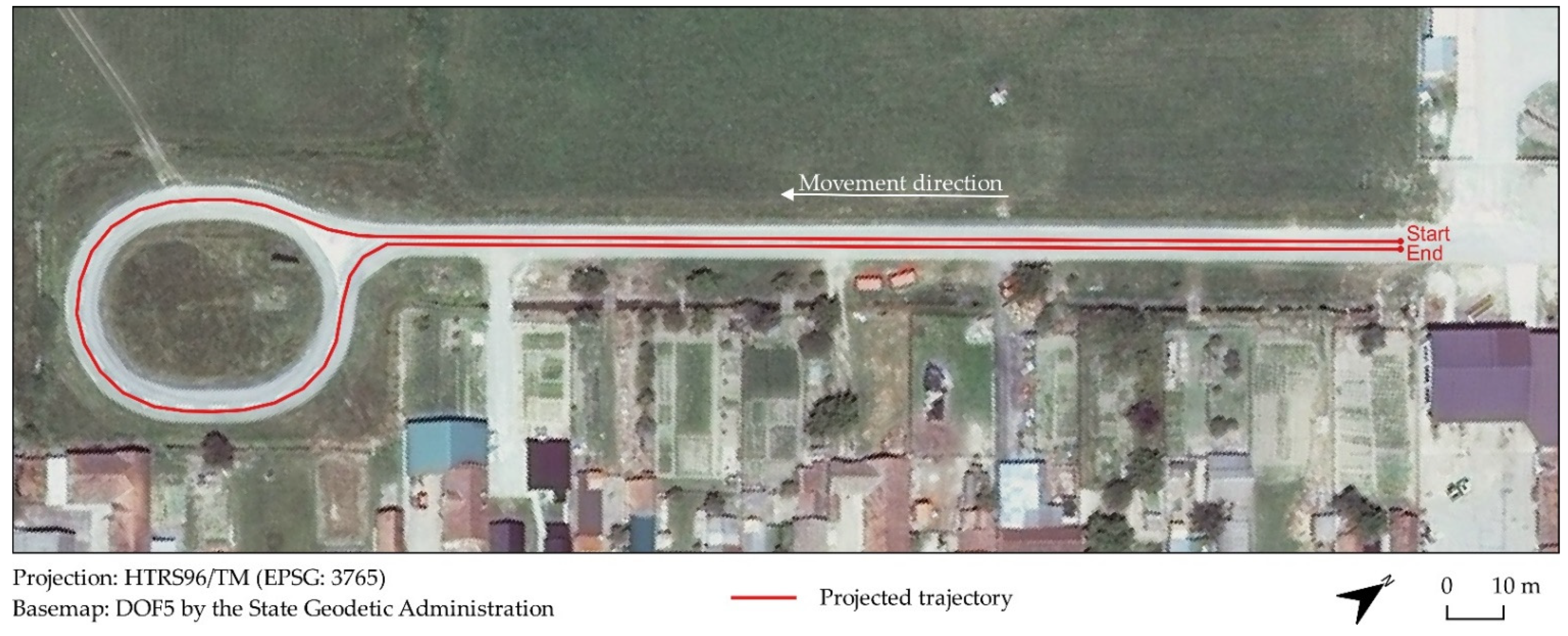
2.1. Study Area

The study area is located in the municipality of Koška in eastern Croatia, which dominantly contains agricultural land traditionally used for intensive agricultural production. The trajectory for the assessment of GNSS positioning was projected on a paved track used for agricultural purposes, connected with an improvised roundabout (Figure 1). These properties simulated the actual movement of the agricultural machinery during the agrotechnical operations, evaluating the GNSS positioning accuracy on both straight and curved sections [21]. The total length of the projected trajectory was 506.97 m. All GNSS observations were georeferenced in the Croatian Terrestrial Reference System (HTRS96/TM).

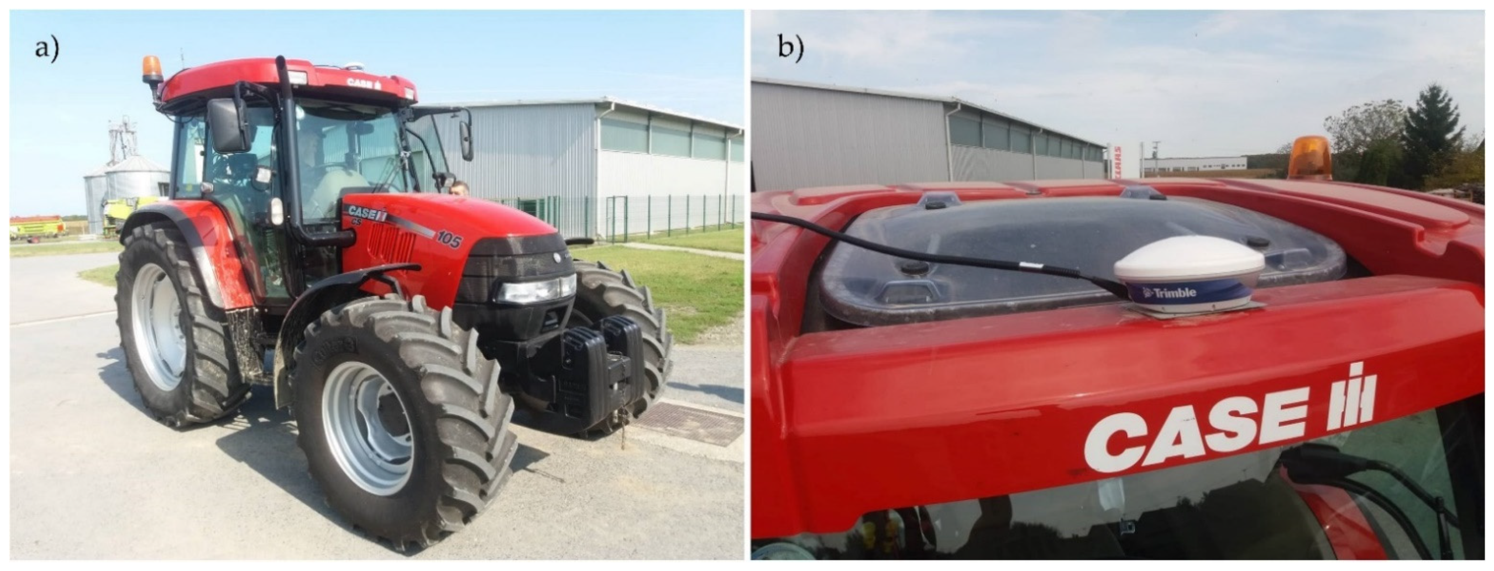
2.2. GNSS RTK Corrections and Field Data Acquisition

A Trimble Ag25 dual-frequency GNSS receiver with a Trimble CFX-750 GNSS controller (Trimble, Sunnyvale, CA, USA) using GPS and GLONASS satellite data were used for GNSS observations (Figure 2). The GNSS positioning and navigation system was equipped on the agricultural tractor Case IH CS 105 PRO (Case IH, Racine, WI, USA), while the Trimble EZ-steer system (Trimble, Sunnyvale, CA, USA) ensured assisted guidance of the vehicle. The same assisted guidance solution minimized subjective steering errors by the operator, with the GNSS receiver dominantly producing positioning errors with a major variability in a previous study [11]. While inferior to the more expensive fully integrated autosteering solution, its practical effectiveness and consistency combined with RTK corrections in a similar application were noted [8]. EZ-steer was integrated and compatible with all evaluated GNSS corrections, applied for both straight and curved sections of the trajectory. The movement speed of the agricultural tractor was constantly 4 km h–1 for all repetitions, simulating the tractor movement speed during the agrotechnical operations, such as sowing and planting [22].
Three GNSS corrections and an absolute positioning method with the smartphone receiving GPS, GLONASS, and Beidou signals were used in the research. All GNSS observations representing the actual trajectory of the agricultural tractor were performed in one epoch, simulating the actual use of GNSS positioning and navigation during agrotechnical operations. Each positioning variant was performed in two repetitions to ensure repeatability of the proposed method, the lower effect of the operator’s subjective assessment, and lower effect of a particular constellation of GNSS satellites [23,24]. Previous studies successfully addressed these conditions either by performing fieldwork in a similar duration to this study under varying satellite constellations [4] or by applying few shorter consecutive repetitions [9].
The three GNSS corrections used included CROPOS, base station, and SBAS. CROPOS with High-Precision Positioning Service (VPPS) was used for RTK observation with the declared horizontal accuracy of 2 cm and vertical accuracy of 4 cm [7]. The GNSS positioning was performed using the 33 permanent base stations in Croatia, distributing mobile RTK corrections in RTCM 3.1 format. Base station variant represented GNSS positioning using the single base station, distributing radio RTK corrections [25]. A commercial solution by the major local agricultural company was used, being 18 km away from the study area. Similar solutions implemented in previous studies achieved a horizontal positioning accuracy up to 2 cm, while a relatively large distance from the base station to the rover is expected to produce a slightly lower accuracy [26]. SBAS is arguably the most widely implemented GNSS solution for agricultural machinery in Croatia due to its low cost, allowing horizontal precision accuracy in the range of 15–25 cm [27]. The European Geostationary Navigation Overlay Service (EGNOS) (European Space Agency, Paris, France) corrections were used in this study, while SBAS solutions are widely available worldwide depending on the location by similar services [28]. Mobile device GNSS positioning using the absolute positioning method was the last variant, as the most widely available method requiring only a smartphone and a free Android tracking app. It was used as a reference for the comparison to other GNSS corrections, with a declared positioning accuracy of more than 3 m [29].
The field observations were conducted on 12 September 2019, with the starting times of the repetitions shown in Table 1. The mission was planned with at least a two-hour difference between repetitions using the respective GNSS corrections to reduce the effect of a particular constellation on the positioning accuracy [30]. Geometric Dilution of Precision (GDOP) values were under a maximum tolerance of six during the entire study [31]. Mission planning was conducted using the Trimble GNSS Planning Online website (https://www.gnssplanning.com/, accessed on 12 October 2021). During the fieldwork, the number of visible GPS + GLONASS satellites ranged from 13 to 16, while four SBAS satellites were visible during the same time. An elevation mask of 10° was applied for GNSS observations. The total electron content (TEC) ranged from 10.19 to 11.21 during this study, with minimal variation during the individual repetitions.

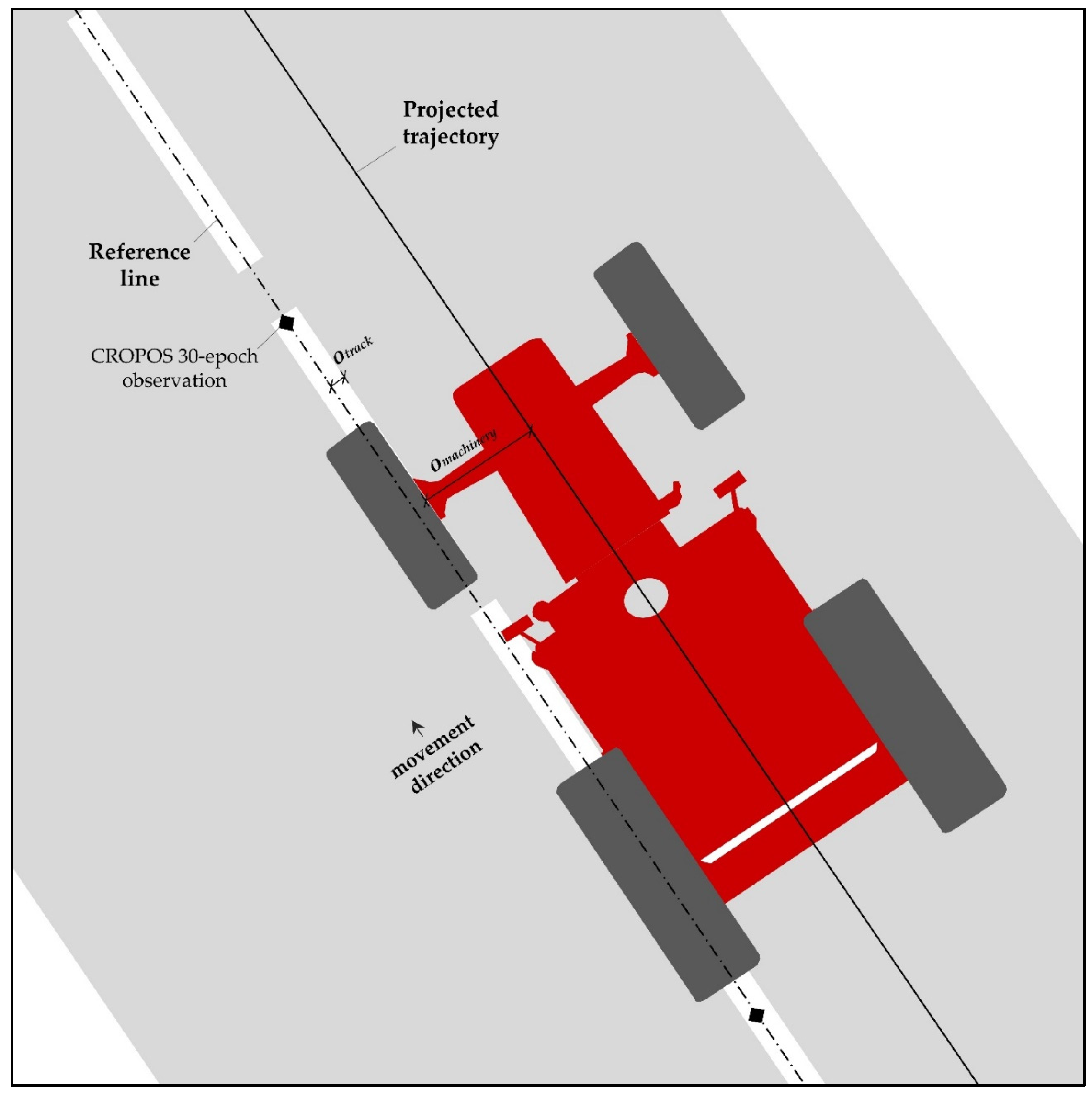
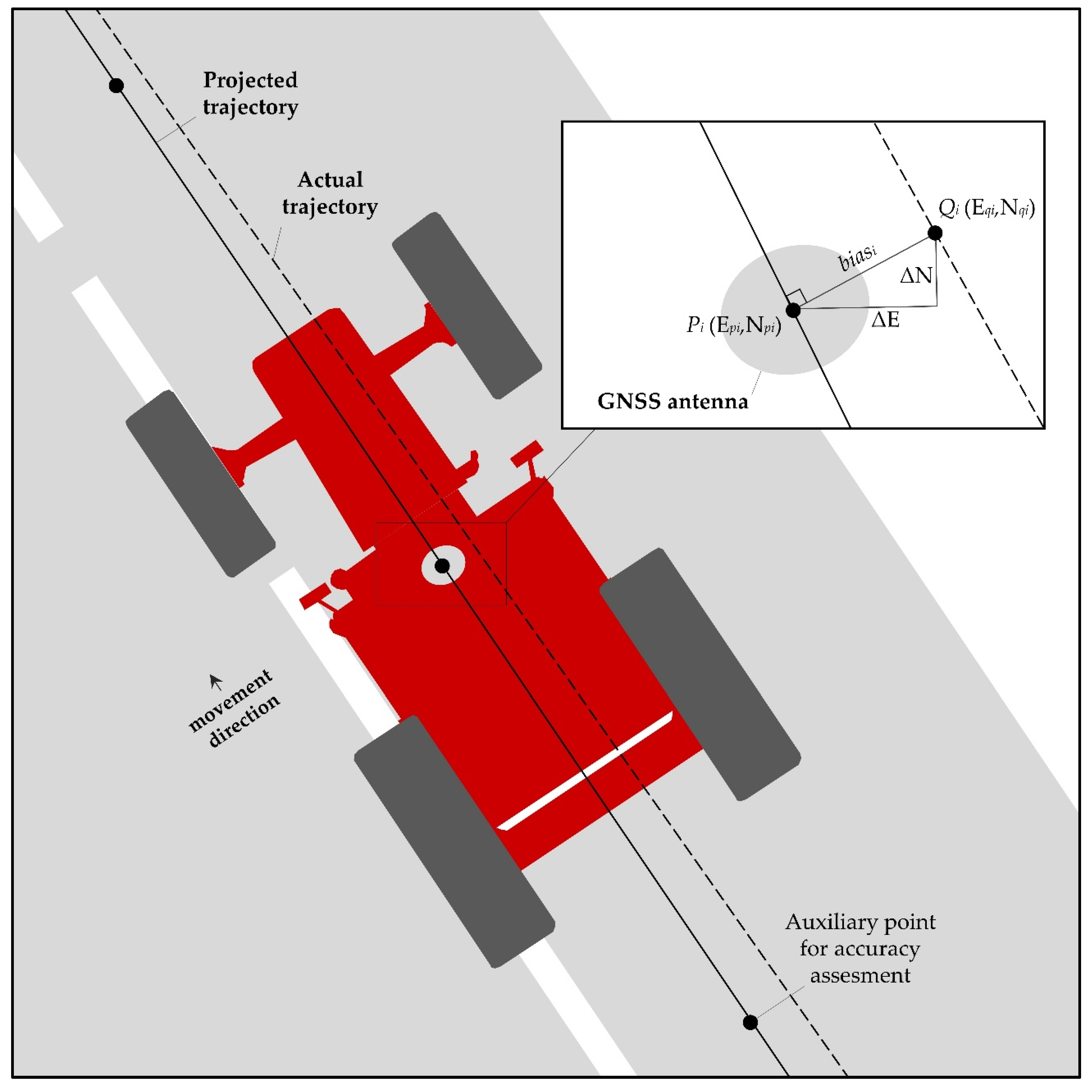
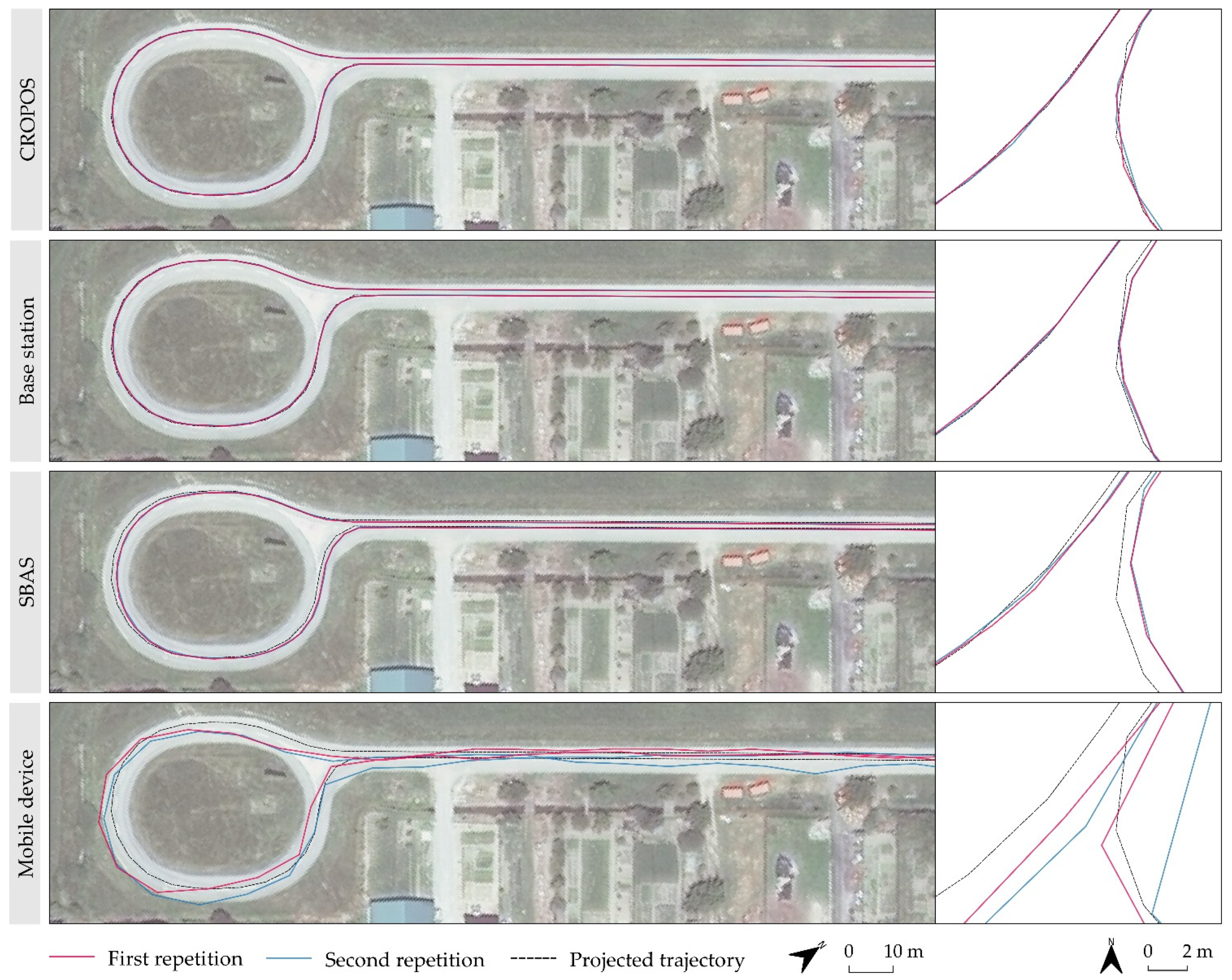
2.3. Determination of the Projected Trajectory and Bias for the Actual Trajectory
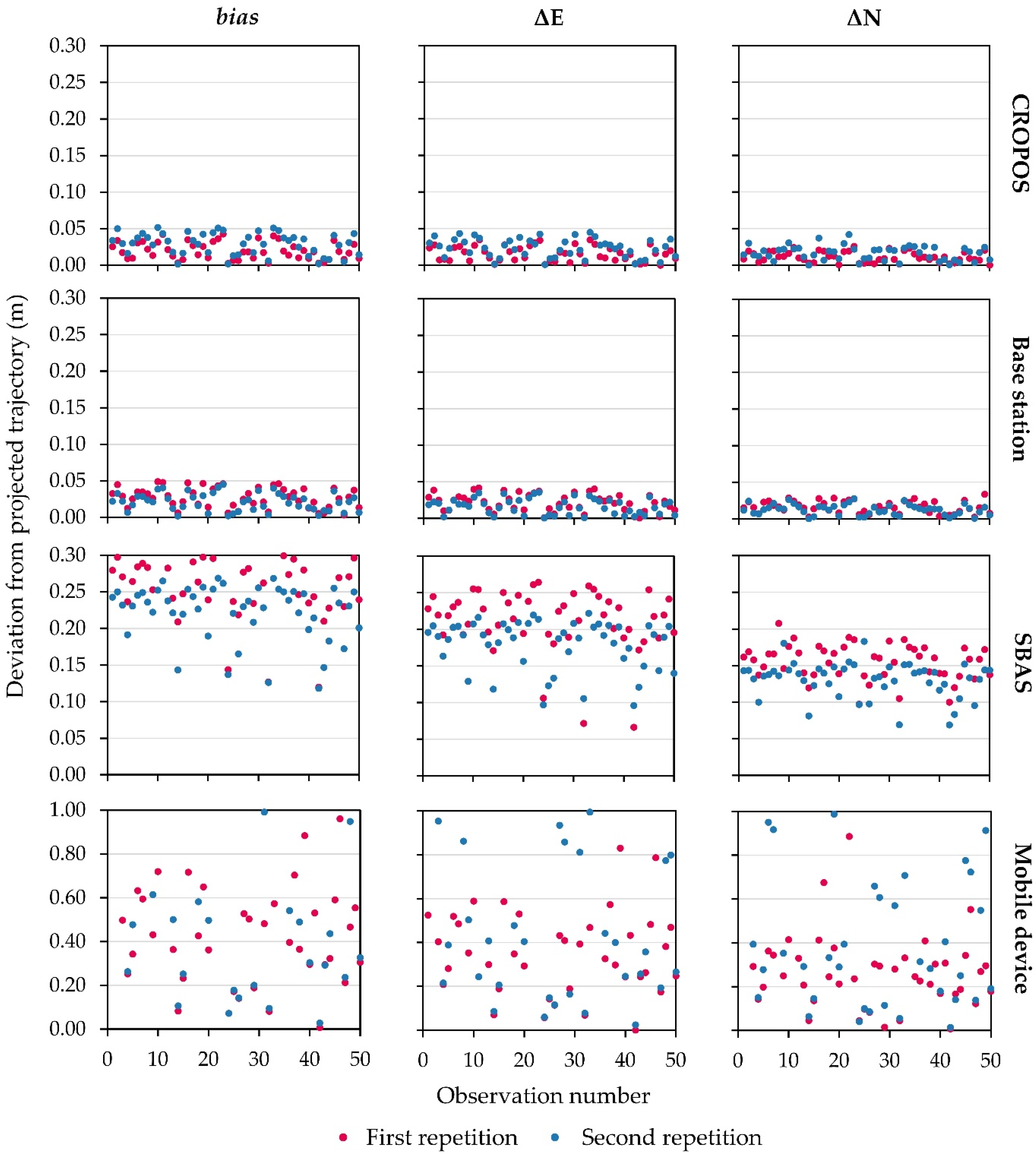
The reference line was defined in the middle of the white road lane on the paved track, being measured every 5 m using 30-epoch GNSS RTK observations with CROPOS corrections (Figure 3). The average coordinates from the 30 epochs were calculated for each location to achieve the highest possible positioning accuracy of the projected trajectory while maintaining time and cost efficiency [32]. The projected trajectory was determined according to the properties of the chosen track and agricultural machinery, based on the offset from the reference line (1):
o total = o track + o machinery
The o track is the sum of corrections specific for the offset of the projected trajectory according to the properties of the study area. In this case, it represented half of the width of the central dividing line for unclassified tracks in Croatia, amounting to 0.060 m. The o machinery is the sum of corrections specific for the offset caused by the dimensions of the agricultural machinery, its mechanical properties relative to the operator, and the placement of the GNSS antenna. A reference for the steering of the agricultural machinery in this study was determined using the width of the front left tire. Therefore, o machinery equaled the length of the front semi-axle corrected by the tire width, which amounted to 0.675 m. A projected trajectory was determined according to the total offset o total from the reference line, which was calculated as the sum of previously determined corrections and amounted to 0.735 m.
Fifty auxiliary points with equal relative distance were generated 10 m apart from each other on the projected trajectory and were used as a reference for the accuracy assessment of GNSS positioning (Figure 4). Accordingly, the positioning error per observation ( bias i ) was determined according to Equation (2):
bias i = Δ E i 2 + Δ N i 2 = ( E pi     E qi ) 2 + ( N pi     N qi ) 2 ,
where i represents one epoch of the GNSS observation, E and N represent the eastern and northern coordinates in the HTRS96/TM projection, p represents the observed location on the actual trajectory, and q represents the perpendicular location on the projected trajectory closest to the observed location p.
The statistical analysis of the observed GNSS field results was performed using R v4.0.3 in RStudio v1.3 (R Foundation, Vienna, Austria). The fundamental properties of two samples of bias determined for each of the repetitions were analyzed using descriptive statistics. Median values were used to evaluate the relationship of the actual GNSS accuracy in the field with the positioning accuracy declared by the provider of the corrections. Minimum and maximum values were used to establish a range of positioning accuracy, while the coefficient of variation (CV) quantified the variability of the positioning accuracy within the repetition. The lower CV values indicated a more uniform accuracy, which benefits the application of a particular GNSS correction in the field due to the increased repeatability [33].
The normal distribution of input samples was evaluated using the Shapiro-Wilk test to determine the suitability of a parametric (t-test) or non-parametric test (Wilcoxon test). The null hypothesis of the Shapiro-Wilk test that the tested GNSS positioning bias is normally distributed was rejected for every p value lower than 0.05 [34]. In these cases, the Wilcoxon non-parametric test was determined as optimal instead of the default selection of the parametric t-test. The difference from the median values of two samples created from the GNSS observations in two repetitions was tested to assess the repeatability of the positioning accuracy for the tested GNSS corrections [35]. A correlation matrix containing Pearson’s correlation coefficients for the evaluated pairs of GNSS positioning bias was used to determine the relationship of the tested GNSS corrections, allowing integrated observation of the positioning accuracy on straight and curved sections of the projected trajectory.

3. Results

The descriptive statistics of the GNSS observations for the total bias and its components per coordinates in HTRS96/TM are presented in Table 2. CROPOS corrections produced the most accurate GNSS positioning in both repetitions, followed by the base station. The smaller deviation from the projected trajectory for these corrections was observed for N coordinates, as the trajectory had a higher range of E coordinates. Tested GNSS correction variants produced higher positioning accuracy in the first repetition characterized with the lower GDOP, with the exception of SBAS. While moderate variability of the CROPOS and base station observations was noted, SBAS produced the lowest CV values of the positioning bias in both repetitions, indicating the most consistent GNSS observation. The mobile device produced the least consistent observations, having a positioning accuracy range from sub-centimeter accuracy up to more than 3 m. A comparative visual representation of the deviations of the tested GNSS positioning variants from the projected trajectory is presented in Figure 5.
The null hypothesis of the Shapiro-Wilk test was rejected for all tested samples, indicating that neither pair of samples observed with the same GNSS correction possessed a normal distribution of values (Table 3). Accordingly, a non-parametric Wilcoxon statistical test was selected for the evaluation of all GNSS observation samples.
The Wilcoxon test indicated that neither of the repetitions from respective GNSS corrections belong in the same population regarding the positioning bias and its components on E and N coordinates (Table 4). A display of the actual trajectories per GNSS correction and their relative location according to the projected trajectory is presented in Figure 6. The actual trajectories of all four GNSS variants were generally closer to the projected trajectory on straight sections, with the least matching on the most curved sections of the projected trajectory.
Positioning bias from the repetitions of particular GNSS corrections resulted in a high correlation for all four varieties, constantly producing values higher than 92% (Table 5). The strongest mutual relationship was observed between CROPOS and Base station observations, with a mean Pearson’s correlation coefficient of 0.948. SBAS also produced a relatively high correlation with both high-precision GNSS RTK corrections, while the mobile device produced a wide range of lower correlation values, indicating low repeatability of the positioning accuracy results.

4. Discussion

This study presented a low-cost method of GNSS positioning accuracy assessment for agricultural machinery, based on the commonly used GNSS corrections in Croatia. Its properties of straightforwardness and adaptability under various conditions in the study area meet the requirements of a potential basis for widespread global application [36]. Unlike available ISO standards for the evaluation of GNSS RTK receivers [17], it simulates the actual movement of the agricultural machinery during the agrotechnical operations, which has more practical importance for the farmers in their work. The majority of technological improvements and applications in precision agriculture are still largely focused on GNSS positioning and navigation, as the basis of all precise agrotechnical operations [37]. Its importance is described in many previous studies and its importance is expected to grow further [38]. Despite its availability and mentioned advantages, the proposed method at the current stage still has two main drawbacks:
  • The retained minor subjective impact of the operator on the GNSS positioning accuracy;
  • The lack of newly available GNSS corrections and multiple study areas.
The first disadvantage of the operator’s subjective impact on the reliability of GNSS observations occurs due to the imperfections regarding steering aim and reaction time [39]. The selection of EZ-steer justifies the selection of two repetitions due to assisted guidance and removal of the vast majority of steering subjective errors caused by the operator. This solution is cost-efficient but not perfectly reliable, which could be resolved with the more expensive use of an autosteering solution in future studies. Additionally, the fewer repetitions are user-friendly to farmers, being time-efficient regarding fieldwork and data processing, allowing the widespread and efficient implementation of the proposed method. However, more repetitions would produce more reliable results and farmers who prioritize additional accuracy over time efficiency should opt for more than two repetitions. These errors have a random character and a previous study indicated that these can be minimized in the process of statistical analysis [40]. The minor subjective assessment of the operator remains a disadvantage of the proposed method but ensures a time-efficient and low-cost property, which can be a priority to farmers. The proposed method is applicable with the autosteering solution, as D’Antonio et al. [8] noted the maximum retention of positioning accuracy by applied GNSS correction but also its practical constraints, because of which it might not be available to a wide range of farmers.
As another more expensive option, the possible upgrade of this method is the implementation of an automated procedure, simultaneously using two GNSS receivers mounted on the agricultural machinery. One GNSS receiver with maximum available accuracy GNSS RTK corrections could be used for an actual reference positioning, which corresponds to CROPOS in this study. The second receiver with GNSS corrections, which are evaluated in the process, coupled with autosteering to remove the effect of human error, could round up an upgraded version of the proposed method. Since the positioning accuracy of the reference receiver equals 2 cm horizontally [7], this approach will be optimal for the assessment of the performance of corrections up to 10 cm, such as SBAS. This approach does not require setting up a projected trajectory, which makes it even more flexible for widespread application. However, this is not a low-cost method and is time-expensive due to the necessity of coupling two GNSS receivers in the same agricultural machinery [41].
While this study covered the most commonly used GNSS corrections for farming purposes in Croatia, the second disadvantage is based on the current lack of testing of the reliability of the proposed method using the additional corrections and study areas. The novel GNSS corrections offer upgrades to the ones tested in this study regarding the global availability and no need for a second GNSS receiver other than the rover [42]. The potential of Trimble RTX [6] and Precise Point Positioning (PPP) [4] was recognized in previous studies for GNSS positioning and navigation in farming. Therefore, their implementation is planned to be evaluated using the proposed method in future studies. The positioning accuracy for tested GNSS corrections declared by its suppliers was determined under conditions that do not correspond to the ones in the field during agricultural operations [43]. Among several factors, this refers to the observation of multiple epochs using the stationary GNSS receiver and observation under uniform conditions. Since the GNSS positioning accuracy under common field conditions in farming is subjected to other secondary effects, such as the availability of mobile Internet [44], or distance to the base station [45], every farmer should at times test the performance of GNSS receivers mounted on agricultural machinery. The distance from the rover to the base station exceeding the one recommended by producers is a particularly frequent case in eastern Croatia, as was the case in this study. While CROPOS solves this issue by calculating the virtual reference stations, the commercial solutions provided by the local agricultural suppliers often rely on a simpler approach, which does not negate the effects of relatively large base-rover distances [46]. The GNSS constellation also affected GNSS positioning accuracy in this study, as observations using CROPOS and base station in the first repetition produced higher positioning accuracy with lower GDOP and TEC compared to the second repetition. The GNSS positioning accuracy results from all four GNSS variations indicated that the farmers could not expect either a positioning accuracy as declared by its suppliers nor uniform and constant values. Therefore, to ensure reliability for agrotechnical operations requiring higher positioning accuracy, such as sowing and planting, high-precision corrections are recommended [4], such as using CROPOS and base station.

5. Conclusions

To match the technological improvement of the low-cost GNSS positioning and navigation solutions regarding hardware development and advanced processing methods, this study proposed the low-cost positioning accuracy assessment method. Besides its affordability for farmers worldwide, its flexibility and straightforwardness allow for the regular examination of GNSS receivers mounted on agricultural machinery without its detachment and in actual field conditions. Present ISO standards for GNSS RTK accuracy assessment cannot be fulfilled adequately and are not suitable for the receiver mounted on agricultural machinery nor do they represent actual field conditions during agrotechnical operations. While the proposed method still has a slight disadvantage of the operator’s subjective impact, various approaches are possible to further reduce this issue. The most suitable ones are an increased number of repetitions and longer trajectory to retain the low-cost property of the method, while the implementation of autosteering would completely remove this impact but requires additional investments.
As the positioning accuracy assessment results based on the four of the most commonly used GNSS corrections in Croatia indicated, the GNSS observations under actual field conditions during agrotechnical operations can produce lower accuracy compared to their declared positioning accuracy. Additionally, some site-specific conditions, such as the availability of mobile Internet signal and the distance to the base station, could produce heterogenous GNSS positioning accuracy, even within a county or a municipality. Therefore, greater emphasis should be put on the local properties and multiple study areas for the assessment of GNSS positioning accuracy in both professional farming activities and future scientific work. Resolving these issues will be a subject of future studies to provide more reliable insight into the current solutions for GNSS positioning and navigation for agricultural machinery under various field conditions.

Author Contributions

Conceptualization, D.R. and I.P.; methodology, D.R.; software, D.R.; validation, D.R.; formal analysis, D.R., I.P., G.H. and M.J.; investigation, D.R. and I.P.; resources, D.R. and I.P.; data curation, D.R.; writing—original draft preparation, D.R.; writing—review and editing, D.R., I.P., G.H. and M.J.; visualization, D.R.; supervision, I.P., G.H. and M.J.; project administration, M.J.; funding acquisition, D.R. and M.J. All authors have read and agreed to the published version of the manuscript.

Funding

This research received no external funding.

Institutional Review Board Statement

Not applicable.

Informed Consent Statement

Not applicable.

Data Availability Statement

Not applicable.

Acknowledgments

The authors thank “Jerković d.o.o.” company for the cooperation during the fieldwork and for the agricultural tractor equipped with the GNSS receiver and necessary corrections for the research. This work was supported by the Faculty of Agrobiotechnical Sciences Osijek as a part of the scientific project “AgroGIT—technical and technological crop production systems, GIS and environment protection”.

Conflicts of Interest

The authors declare no conflict of interest.

References

  1. Tayebi, A.; Gomez, J.; Fernandez, M.; Saez de Adana, F.; Gutierrez, O. Low-Cost Experimental Application of Real-Time Kinematic Positioning for Increasing the Benefits in Cereal Crops. Int. J. Agric. Biol. Eng. 2021, 14, 194–199. [Google Scholar] [CrossRef]
  2. Ayerdi Gotor, A.; Marraccini, E.; Leclercq, C.; Scheurer, O. Precision Farming Uses Typology in Arable Crop-Oriented Farms in Northern France. Precis. Agric. 2020, 21, 131–146. [Google Scholar] [CrossRef]
  3. Toriyama, K. Development of Precision Agriculture and ICT Application Thereof to Manage Spatial Variability of Crop Growth. Soil Sci. Plant Nutr. 2020, 66, 811–819. [Google Scholar] [CrossRef]
  4. Guo, J.; Li, X.; Li, Z.; Hu, L.; Yang, G.; Zhao, C.; Fairbairn, D.; Watson, D.; Ge, M. Multi-GNSS Precise Point Positioning for Precision Agriculture. Precis. Agric. 2018, 19, 895–911. [Google Scholar] [CrossRef] [Green Version]
  5. Zhao, B.; Li, J.; Wang, L.; Shi, Y. Positioning Accuracy Assessment of a Commercial RTK UAS. In Proceedings of the Autonomous Air and Ground Sensing Systems for Agricultural Optimization and Phenotyping V; Thomasson, J.A., TorresRua, A.F., Eds.; SPIE-International Society Optical Engineering: Bellingham, UK, 2020; Volume 11414, p. 1141409. [Google Scholar]
  6. Carballido, J.; Perez-Ruiz, M.; Emmi, L.; Agüera, J. Comparison of Positional Accuracy between RTK and RTX GNSS Based on the Autonomous Agricultural Vehicles under Field Conditions. Appl. Eng. Agric. 2014, 30, 361–366. [Google Scholar] [CrossRef] [Green Version]
  7. Republic of Croatia, State Geodetic Administration CROPOS Users’ Manual. Available online: https://www.cropos.hr/files/docs/cropos_users-manual.pdf (accessed on 22 November 2021).
  8. D’Antonio, P.; D’Antonio, C.; Evangelista, C.; Doddato, V. Satellite Guidance Systems in Agriculture: Experimental Comparison between EZ-Steer/RTK and AUTOPILOT/EGNOS. J. Agric. Eng. 2013, 44, 173–177. [Google Scholar] [CrossRef]
  9. Scarfone, A.; Picchio, R.; del Giudice, A.; Latterini, F.; Mattei, P.; Santangelo, E.; Assirelli, A. Semi-Automatic Guidance vs. Manual Guidance in Agriculture: A Comparison of Work Performance in Wheat Sowing. Electronics 2021, 10, 825. [Google Scholar] [CrossRef]
  10. Zhang, J.; Liu, G.; Huang, J.; Zhang, Y. A Study on the Time Lag and Compensation of a Variable-Rate Fertilizer Applicator. Appl. Eng. Agric. 2021, 37, 43–52. [Google Scholar] [CrossRef]
  11. Perez-Ruiz, M.; Carballido, J.; Agueera, J.; Gil, J.A. Assessing GNSS Correction Signals for Assisted Guidance Systems in Agricultural Vehicles. Precis. Agric. 2011, 12, 639–652. [Google Scholar] [CrossRef]
  12. Catania, P.; Comparetti, A.; Febo, P.; Morello, G.; Orlando, S.; Roma, E.; Vallone, M. Positioning Accuracy Comparison of GNSS Receivers Used for Mapping and Guidance of Agricultural Machines. Agronomy 2020, 10, 924. [Google Scholar] [CrossRef]
  13. Alkan, R.M.; Erol, S.; İlçi, V.; Ozulu, İ.M. Comparative Analysis of Real-Time Kinematic and PPP Techniques in Dynamic Environment. Measurement 2020, 163, 107995. [Google Scholar] [CrossRef]
  14. Gomez-Gil, J.; Alonso-Garcia, S.; Gómez-Gil, F.J.; Stombaugh, T. A Simple Method to Improve Autonomous GPS Positioning for Tractors. Sensors 2011, 11, 5630–5644. [Google Scholar] [CrossRef] [PubMed] [Green Version]
  15. Valente, D.S.M.; Momin, A.; Grift, T.; Hansen, A. Accuracy and Precision Evaluation of Two Low-Cost RTK Global Navigation Satellite Systems. Comput. Electron. Agric. 2020, 168, 105142. [Google Scholar] [CrossRef]
  16. Kaivosoja, J.; Linkolehto, R. GNSS Error Simulator for Farm Machinery Navigation Development. Comput. Electron. Agric. 2015, 119, 166–177. [Google Scholar] [CrossRef]
  17. Garrido-Carretero, M.S.; de Lacy-Perez de los Cobos, M.C.; Borque-Arancon, M.J.; Ruiz-Armenteros, A.M.; Moreno-Guerrero, R.; Gil-Cruz, A.J. Low-Cost GNSS Receiver in RTK Positioning under the Standard ISO-17123-8: A Feasible Option in Geomatics. Measurement 2019, 137, 168–178. [Google Scholar] [CrossRef]
  18. Preseren, P.P.; Mencin, A.; Stopar, B. Analysis of Gnss-Rtk Instruments Testing on the Iso 17123-8 Instructions. Geod. Vestn. 2010, 54, 607–626. [Google Scholar] [CrossRef]
  19. Paziewski, J.; Wielgosz, P. Investigation of Some Selected Strategies for Multi-GNSS Instantaneous RTK Positioning. Adv. Space Res. 2017, 59, 12–23. [Google Scholar] [CrossRef]
  20. Wang, Q.; Yang, C.; Wang, Y.; Wu, S. Application of Low Cost Integrated Navigation System in Precision Agriculture. Intell. Autom. Soft Comput. 2020, 26, 1419–1428. [Google Scholar] [CrossRef]
  21. Passalaqua, B.P.; Molin, J.P. Path Errors in Sugarcane Transshipment Trailers. Eng. Agric. 2020, 40, 223–231. [Google Scholar] [CrossRef]
  22. Shi, Y.; Xi, X.; Gan, H.; Shan, X.; Zhang, Y.; Shen, H.; Zhang, R. Design and Experiment of Row-Controlled Fertilizing–Weeding Machine for Rice Cultivation. Agriculture 2021, 11, 527. [Google Scholar] [CrossRef]
  23. de Silva, T.M.A.; de Mayrink, G.O.; Valente, D.S.M.; Queiroz, D.M. Integration of a Low-Cost Global Navigation Satellite System to a Single-Board Computer Using Kalman Filtering. Eng. Agric. 2019, 39, 323–330. [Google Scholar] [CrossRef]
  24. Akkamis, M.; Keskin, M.; Sekerli, Y.E. Comparative Appraisal of Three Low-Cost GPS Speed Sensors with Different Data Update Frequencies. AgriEngineering 2021, 3, 423–437. [Google Scholar] [CrossRef]
  25. Armenteros, J.A.; Gil, A.J. A Methodology for Creating Rtk Positioning Coverage Maps Via a Radio Modem Link to Cors Stations. Surv. Rev. 2010, 42, 406–411. [Google Scholar] [CrossRef]
  26. He, K.; Xu, T.; Forste, C.; Petrovic, S.; Barthelmes, F.; Jiang, N.; Flechtner, F. GNSS Precise Kinematic Positioning for Multiple Kinematic Stations Based on A Priori Distance Constraints. Sensors 2016, 16, 470. [Google Scholar] [CrossRef] [PubMed] [Green Version]
  27. Li, L.; Jia, C.; Zhao, L.; Cheng, J.; Liu, J.; Ding, J. Real-Time Single Frequency Precise Point Positioning Using SBAS Corrections. Sensors 2016, 16, 1261. [Google Scholar] [CrossRef] [Green Version]
  28. Nie, Z.; Zhou, P.; Liu, F.; Wang, Z.; Gao, Y. Evaluation of Orbit, Clock and Ionospheric Corrections from Five Currently Available SBAS L1 Services: Methodology and Analysis. Remote Sens. 2019, 11, 411. [Google Scholar] [CrossRef] [Green Version]
  29. Liu, Q.; Gao, C.; Peng, Z.; Zhang, R.; Shang, R. Smartphone Positioning and Accuracy Analysis Based on Real-Time Regional Ionospheric Correction Model. Sensors 2021, 21, 3879. [Google Scholar] [CrossRef]
  30. Meneghini, C.; Parente, C. Advantages of Multi GNSS Constellation: GDOP Analysis for GPS, GLONASS and Galileo Combinations. Int. J. Eng. Technol. Innov. 2017, 7, 1–10. [Google Scholar]
  31. Pereira, F.; Selva, D. Exploring the Architecture Trade Space of NextGen Global Navigation Satellite Systems. In Proceedings of the 2019 IEEE Aerospace Conference, Big Sky, MT, USA, 2–9 March 2019; IEEE: New York, NY, USA, 2019. [Google Scholar]
  32. Ding, W.; Sun, W.; Gao, Y.; Wu, J. Carrier Phase-Based Precise Heading and Pitch Estimation Using a Low-Cost GNSS Receiver. Remote Sens. 2021, 13, 3642. [Google Scholar] [CrossRef]
  33. Scott, D.N.; Brogan, D.J.; Lininger, K.B.; Schook, D.M.; Daugherty, E.E.; Sparacino, M.S.; Patton, A.I. Evaluating Survey Instruments and Methods in a Steep Channel. Geomorphology 2016, 273, 236–243. [Google Scholar] [CrossRef] [Green Version]
  34. Pepe, M.; Costantino, D.; Vozza, G.; Alfio, V.S. Comparison of Two Approaches to GNSS Positioning Using Code Pseudoranges Generated by Smartphone Device. Appl. Sci. 2021, 11, 4787. [Google Scholar] [CrossRef]
  35. Kazmierski, K.; Hadas, T.; Sośnica, K. Weighting of Multi-GNSS Observations in Real-Time Precise Point Positioning. Remote Sens. 2018, 10, 84. [Google Scholar] [CrossRef] [Green Version]
  36. Park, K.W.; Park, J.-I.; Park, C. Efficient Methods of Utilizing Multi-SBAS Corrections in Multi-GNSS Positioning. Sensors 2020, 20, 256. [Google Scholar] [CrossRef] [PubMed] [Green Version]
  37. Mahato, S.; Rakshit, P.; Santra, A.; Dan, S.; Tiglao, N.C.; Bose, A. A GNSS-Enabled Multi-Sensor for Agricultural Applications. J. Inform. Optim. Sci. 2019, 40, 1763–1772. [Google Scholar] [CrossRef]
  38. Marucci, A.; Colantoni, A.; Zambon, I.; Egidi, G. Precision Farming in Hilly Areas: The Use of Network RTK in GNSS Technology. Agriculture 2017, 7, 60. [Google Scholar] [CrossRef] [Green Version]
  39. Wu, C.; Zhang, W.; You, X.; Du, N. Which Accuracy Levels of Positioning Technologies Do Drivers Really Need in Connected Vehicle Settings for Safety? Accid. Anal. Prev. 2021, 157, 106106. [Google Scholar] [CrossRef]
  40. Dvulit, P.D.; Savchuk, S.; Sosonka, I. The Processing of GNSS Observation by Non-Classical Error Theory of Measurements. Geodynamics 2020, 28, 19–28. [Google Scholar] [CrossRef]
  41. de Bakker, P.F.; Tiberius, C.C.J.M. Real-Time Multi-GNSS Single-Frequency Precise Point Positioning. GPS Solut. 2017, 21, 1791–1803. [Google Scholar] [CrossRef] [Green Version]
  42. Atiz, O.F.; Shakor, A.Q.; Ogutcu, S.; Alcay, S. Performance Investigation of Trimble RTX Correction Service with Multi-GNSS Constellation. Surv. Rev. 2021, 1–11. [Google Scholar] [CrossRef]
  43. Dabrowski, P.S.; Specht, C.; Felski, A.; Koc, W.; Wilk, A.; Czaplewski, K.; Karwowski, K.; Jaskolski, K.; Specht, M.; Chrostowski, P.; et al. The Accuracy of a Marine Satellite Compass under Terrestrial Urban Conditions. J. Mar. Sci. Eng. 2020, 8, 18. [Google Scholar] [CrossRef] [Green Version]
  44. Mayer, P.; Magno, M.; Berger, A.; Benini, L. RTK-LoRa: High-Precision, Long-Range, and Energy-Efficient Localization for Mobile IoT Devices. IEEE Trans. Instrum. Meas. 2021, 70, 3000611. [Google Scholar] [CrossRef]
  45. Deng, J.; Wang, S.L. Divisional Ambiguity Resolution for Long Range Reference Stations in Network RTK. Surv. Rev. 2015, 47, 272–278. [Google Scholar] [CrossRef]
  46. Berber, M.; Arslan, N. Network RTK: A Case Study in Florida. Measurement 2013, 46, 2798–2806. [Google Scholar] [CrossRef]
Figure 1. Study area and the trajectory for the accuracy assessment of GNSS RTK corrections.
Applsci 12 00693 g001
Figure 2. The equipment used for the research: (a) Case IH CS 105 PRO agricultural tractor, (b) Trimble Ag25 GNSS receiver with the CFX-750 controller.
Applsci 12 00693 g002
Figure 3. Definition of the projected trajectory according to the reference line.
Applsci 12 00693 g003
Figure 4. Determination of GNSS positioning accuracy according to the projected trajectory.
Applsci 12 00693 g004
Figure 5. A comparative visual representation of deviations from the projected trajectory for four tested GNSS positioning variants.
Applsci 12 00693 g005
Figure 6. Actual trajectories per GNSS correction in two repetitions and their location according to the projected trajectory, with an enlarged display of the connection of straight and curved sections.
Applsci 12 00693 g006
Table 1. Start time periods and GDOP for the used RTK corrections in two repetitions according to Trimble GNSS Planning Online.
RepetitionGNSS CorrectionsStarting Time
(UTC + 01:00)
Number of SatellitesGDOPTEC
GPSGLONASSTotal
1stCROPOS10:0085132.1410.19
Base station10:1586141.8310.54
SBAS10:30106161.7110.65
Mobile device10:4596151.6110.75
2ndCROPOS13:00124162.3010.81
Base station13:15115161.8410.97
SBAS13:30115161.8110.99
Mobile device13:45115161.6811.04
Table 2. Descriptive statistics of the bias produced by the used GNSS RTK corrections from the projected trajectory.
GNSS CorrectionsFirst RepetitionSecond Repetition
nMedian (m)CVMin (m)Max (m)nMedian (m)CVMin (m)Max (m)
biasCROPOS500.0190.6040.0030.043500.0290.5110.0020.052
Base station500.0270.4960.0030.049500.0320.5720.0020.045
SBAS500.2630.1740.1200.323500.2230.1720.1180.269
Mobile device500.8420.9790.0073.611501.3400.7620.0283.739
ΔECROPOS500.0150.6710.0000.035500.0230.5380.0010.045
Base station500.0220.5420.0010.041500.0160.6470.0000.036
SBAS500.2120.1990.0660.264500.1790.1900.0960.222
Mobile device500.5810.8030.0031.788501.0060.7590.0243.358
ΔNCROPOS500.0110.6420.0000.026500.0160.5940.0000.042
Base station500.0160.5130.0020.033500.0120.5770.0000.028
SBAS500.1550.1540.0970.207500.1310.1870.0690.183
Mobile device500.5481.3340.0073.536500.8150.9330.0143.170
Table 3. Shapiro-Wilk normality test results for GNSS positioning bias.
GNSS Corrections1st Repetition2nd RepetitionNormality Observed
WpWp
biasCROPOS0.94110.01490.94620.0239no
Base station0.95310.04560.96330.1218no
SBAS0.88150.00010.8610>0.0001no
Mobile device0.7884>0.00010.9287>0.0001no
ΔECROPOS0.94130.01510.96300.1186no
Base station0.96210.10850.94280.0174no
SBAS0.8310>0.00010.8646>0.0001no
Mobile device0.8640>0.00010.9296>0.0001no
ΔNCROPOS0.94420.01980.97030.2376no
Base station0.96220.04970.97560.3852no
SBAS0.96880.20580.91580.0017no
Mobile device0.6329>0.00010.8658>0.0001no
Table 4. Wilcoxon test results for GNSS positioning bias.
GNSS CorrectionsWpSignificantly Different Medians
biasCROPOS7840.0013yes
Base station15870.0204yes
SBAS1962>0.0001yes
Mobile device37120.0017yes
ΔECROPOS7900.0015yes
Base station15780.0240yes
SBAS1940>0.0001yes
Mobile device35590.0004yes
ΔNCROPOS8500.0059yes
Base station15700.0276yes
SBAS1894>0.0001yes
Mobile device38140.0038yes
Table 5. A correlation matrix of positioning bias per GNSS correction and their repetitions.
C1C2B1B2S1S2M1M2
C11.000
C20.9211.000
B10.9230.9651.000
B20.9520.9520.9581.000
S10.8510.9080.8840.8811.000
S20.8330.9150.9050.8670.9581.000
M10.6600.6230.6260.6170.5710.5511.000
M20.8150.7850.7980.7830.7220.7090.9381.000
C1 and C2: CROPOS repetitions, B1 and B2: Base station repetitions, S1 and S2: SBAS repetitions, D1 and D2: Mobile device repetitions.
Publisher’s Note: MDPI stays neutral with regard to jurisdictional claims in published maps and institutional affiliations.

