
Ground-Penetrating Radar Prospections to Image the Inner Structure of Coastal Dunes at Sites Characterized by Erosion and Accretion (Northern Tuscany, Italy)


Abstract
:1. Introduction
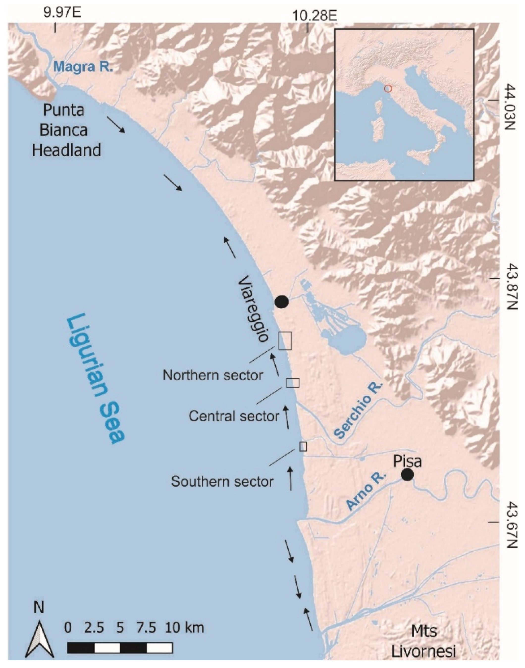
2. Study Area
2.1. Geography, Geomorphology and Sediment Supply
2.2. Investigated Sites
3. Materials and Methods
4. Results
4.1. Data Processing
4.2. GPR Surface and Facies
4.3. GPR Facies Association and Interpretation
5. Discussion and Conclusions
Author Contributions
Funding
Institutional Review Board Statement
Informed Consent Statement
Data Availability Statement
Acknowledgments
Conflicts of Interest
References
- Reading, H.G. Sedimentary Environments: Processes, Facies and Stratigraphy, 3rd ed.; Wiley-Blackwel: London, UK, 1996; 704p. [Google Scholar]
- Tamura, T. Beach ridges and prograded beach deposits as palaeoenvironment records. Earth Sci. Rev. 2012, 114, 279–297. [Google Scholar] [CrossRef]
- Carter, R.W.G. The morphodynamics of beach-ridge formation: Magilligan, Northern Ireland. Mar. Geol. 1986, 73, 191–214. [Google Scholar] [CrossRef]
- Lancaster, N.; Nickling, W.G.; McKenna Neuman, C. Particle size and sorting characteristics of sand in transport on the stoss slope of a small reversing dune. Geomorphology 2002, 43, 233–242. [Google Scholar] [CrossRef]
- Fraser, C.; Hill, P.R.; Allard, M. Morphology and facies architecture of a falling sea level strandplain, Umiujaq, Hudson Bay, Canada. Sedimentology 2005, 52, 141–160. [Google Scholar] [CrossRef]
- Buynevich, I.V.; Bitinas, A.; Pupienis, D. Lithological anomalies in a relict coastal dune: Geophysical and paleoenvironmental markers. Geoph. Res. Lett. 2007, 34, L09707. [Google Scholar] [CrossRef] [Green Version]
- González-Villanueva, R.; Costas, S.; Pérez-Arlucea, M.; Jerez, S.; Trigo, R.M. Impact of atmospheric circulation patterns on coastal dune dynamics, NW Spain. Geomorphology 2013, 185, 96–109. [Google Scholar] [CrossRef] [Green Version]
- Hede, M.U.; Bendixen, M.; Clemmensen, L.B.; Kroon, A.; Nielsen, L. Joint interpretation of beach-ridge architecture and coastal topography show the validity of sea-level markers observed in ground-penetrating radar data. Holocene 2013, 23, 1238–1246. [Google Scholar] [CrossRef]
- Clemmensen, L.B.; Nielsen, L.; Bendixen, M.; Murrey, A.S. Morphology and sedimentary architecture of a beach-ridge system (Anholt, the Kattegat sea): A record of punctuated coastal progradation and sea-level change over the past ~1000 years. Boreas 2012, 41, 422–434. [Google Scholar] [CrossRef]
- Clemmensen, L.B.; Hansen, K.W.T.; Kroon, A. Storminess variation at Skagen, northern Denmark since AD 1860: Relations to climate change and implications for coastal dunes. Aeolian Res. 2014, 15, 101–112. [Google Scholar] [CrossRef]
- Lindhorst, S.; Schutter, S. Polar gravel beach-ridge systems: Sedimentary architecture, genesis, and implications for climate reconstructions (South Shetland Islands/Western Antarctic Peninsula). Geomorphology 2014, 221, 187–203. [Google Scholar] [CrossRef]
- Lindhorst, S.; Betzler, C. The climate-archive dune: Sedimentary record of annual wind intensity. Geology 2016, 44, 711–714. [Google Scholar] [CrossRef]
- Hallin, C.; Larson, M.; Hanson, H. Simulating beach and dune evolution at decadal to centennial scale under rising sea levels. PLoS ONE 2019, 14, e0215651. [Google Scholar] [CrossRef] [Green Version]
- Neal, A. Ground-penetrating radar and its use in sedimentology: Principles, problems and progress. Earth-Sci. Rev. 2004, 66, 261–330. [Google Scholar] [CrossRef]
- Schenk, C.J.; Gautier, D.L.; Olhoeft, G.R.; Lucius, J.E. Internal structure of an eolian dune using ground-penetrating radar. In Eolian Sediments: Ancient and Modern; Pye, K., Lancaster, N., Eds.; International Association of Sedimentologists, Special Publication 16; Blackwell: Oxford, UK, 1993; pp. 61–69. [Google Scholar]
- Harari, Z. Ground-penetrating radar (GPR) for imaging stratigraphic features and groundwater in sand dunes. J. Appl. Geoph. 1996, 36, 43–52. [Google Scholar] [CrossRef]
- Bano, M.; Girard, J.F. Radar reflections and water content estimation of aeolian sand dune. Geoph. Res. Lett. 2001, 28, 3207–3210. [Google Scholar] [CrossRef]
- Bristow, C.S.; Chroston, P.N.; Bailey, S.D. The structure and development of foredunes on a locally prograding coast: Insights from ground-penetrating radar surveys, Norfolk, UK. Sedimentology 2000, 47, 923–944. [Google Scholar] [CrossRef]
- Neal, A.; Roberts, C.L. Application of ground-penetrating radar (GPR) to sedimentological, geomorphological and geoarchaeological studies in coastal environments. In Coastal and Estuarine Environments: Sedimentology, Geomorphology and Geoarchaeology; Pye, K., Allen, J.R.L., Eds.; Special Publication of the Geological Society of London 175; Geological Society of London: London, UK, 2000; pp. 139–171. [Google Scholar]
- Neal, A.; Roberts, C.L. Internal structure of a trough blowout, determined from migrated ground-penetrating radar profiles. Sedimentology 2001, 48, 791–810. [Google Scholar] [CrossRef]
- Neal, A.; Pontee, N.I.; Pye, K.; Richards, J. Internal structure of mixed-sand-and gravel beach deposits revealed using ground-penetrating radar. Sedimentology 2002, 49, 789–804. [Google Scholar] [CrossRef]
- Jol, H.M.; Lawton, D.C.; Smith, D.G. Ground Penetrating Radar: 2D and 3D subsurface imaging of a coastal barrier spit, Long Beach, WA, USA. Geomorphology 2003, 53, 165–181. [Google Scholar] [CrossRef]
- Costas, S.; Alejo, I.; Rial, F.; Lorenzo, H.; Nombela, M.A. Cyclical evolution of a modern transgressive sand barrier in NW-Spain elucidated by GPR and aerial photo. J. Sed. Res. 2006, 76, 1077–1092. [Google Scholar] [CrossRef]
- Tamura, T.; Murakami, F.; Nanayama, F.; Watanabe, K.; Saito, Y. Ground-penetrating radar profiles of Holocene raised-beach deposits in the Kujukuri strand plain, Pacific coast of eastern Japan. Mar. Geol. 2008, 248, 11–27. [Google Scholar] [CrossRef]
- Nielsen, L.; Clemmensen, L.B. Sea-level markers identified in ground-penetrating radar data collected across a modern beach ridge system in a microtidal regime. Terra Nova 2009, 21, 474–479. [Google Scholar] [CrossRef]
- Scheffers, A.; Engel, M.; Scheffers, S.; Squire, P.; Kelletat, D. Beach ridge systems–archives for Holocene coastal events? Progr. Phys. Geogr. 2012, 36, 5–37. [Google Scholar] [CrossRef]
- Özpolat, E.; Şahiner, E.; Özcan, O.; Demir, T.; Owen, L.A. Late-Holocene landscape evolution of a delta from foredune ridges: Seyhan Delta, Eastern Mediterranean, Turkey. Holocene 2021, 31, 760–777. [Google Scholar] [CrossRef]
- Amorosi, A.; Milli, S. Late Quaternary depositional architecture of Po and Tevere river deltas (Italy) and worldwide comparison with coeval deltaic successions. Sed. Geol. 2001, 144, 357–375. [Google Scholar] [CrossRef]
- Vella, C.; Fleury, T.J.; Raccasi, G.; Provansal, M.; Sabatier, F.; Bourcier, M. Evolution of the Rhône delta plain in the Holocene. Mar. Geol. 2005, 222, 235–265. [Google Scholar] [CrossRef]
- Pranzini, E. Airborne LIDAR survey applied to the analysis of the historical evolution of the Arno River delta (Italy). J. Coast. Res. 2007, 50, 400–409. [Google Scholar]
- Giraudi, C.; Tata, C.; Paroli, L. Late Holocene evolution of Tiber river delta and geoarchaeology of Claudius and Trajan Harbor, Rome. Geoarchaeology 2009, 24, 371–382. [Google Scholar] [CrossRef]
- Anthony, E.J.; Marriner, N.; Morhange, C. Human influence and the changing geomorphology of Mediterranean deltas and coasts over the last 6000 years: From progradation to destruction phase? Earth-Sci. Rev. 2014, 139, 336–361. [Google Scholar] [CrossRef]
- Bertoni, D.; Bini, M.; Luppichini, M.; Cipriani, L.E.; Carli, A.; Sarti, G. Anthropogenic impact on beach heterogeneity within a littoral cell (northern Tuscany, Italy). J. Mar. Sci. Eng. 2021, 9, 151. [Google Scholar] [CrossRef]
- Bini, M.; Casarosa, N.; Ribolini, A. L’evoluzione diacronica della linea di riva del litorale Pisano (1938–2004) sulla base del confronto di immagini aeree georeferenziate. Atti Società Toscana Scienze Naturali Mem. Ser. A 2008, 113, 1–12. [Google Scholar]
- Rossi, V.; Amorosi, A.; Sarti, G.; Potenza, M. Influence of inherited topography on the Holocene sedimentary evolution of coastal systems: An example from Arno coastal plain (Tuscany, Italy). Geomorphology 2011, 135, 117–128. [Google Scholar] [CrossRef]
- Sarti, G.; Bini, M.; Giacomelli, S. The growth and decline of Pisa (Tuscany, Italy) up to the Middle Ages: Correlations with landscape and geology. Il Quaternario 2010, 23, 311–322. [Google Scholar]
- Cavazza, S. Regionalizzazione geomorfologica del trasporto solido in sospensione dei corsi d’acqua tra il Magra e l’Ombrone. Atti Società Toscana Scienze Naturali Mem. Ser. A 1984, 91, 119–132. [Google Scholar]
- Bini, M.; Casarosa, N.; Luppichini, M. Exploring the relationship between river discharge and coastal erosion: An integrated approach applied to the Pisa coastal plain (Italy). Remote Sens. 2021, 13, 226. [Google Scholar] [CrossRef]
- Aiello, E.; Bartolini, C.; Caputo, C.; D’Alessandro, L.; Fanucci, F.; Fierro, G.; Gnaccolini, M.; La Monica, G.B.; Lupia Palmieri, E.; Piccazzo, M.; et al. Il trasporto litoraneo lungo la costa toscana tra la foce del fiume Magra ed i Monti dell’Uccellina. Boll. Soc. Geol. Ital. 1975, 94, 1519–1571. [Google Scholar]
- Gandolfi, G.; Paganelli, L. Il litorale pisano-versiliese (Area campione Alto Tirreno). Composizione, provenienza e dispersione delle sabbie. Boll. Soc. Geol. Ital. 1975, 94, 1273–1295. [Google Scholar]
- Cipriani, L.E.; Ferri, S.; Iannotta, P.; Paolieri, F.; Pranzini, E. Morfologia e dinamica dei sedimenti del litorale della Toscana settentrionale. Stud. Cost. 2001, 4, 119–156. [Google Scholar]
- Bertoni, D.; Giacomelli, S.; Ciulli, L.; Sarti, G. Litho-sedimentological and morphodynamic characterization of the Pisa Province coastal area (northern Tuscany, Italy). J. Maps 2020, 16, 108–116. [Google Scholar] [CrossRef] [Green Version]
- Bertoni, D.; Biagioni, C.; Sarti, G.; Ciccarelli, D.; Ruocco, M. The role of sediment grain-size, mineralogy, and beach morphology on plant communities of two Mediterranean coastal dune systems. Ital. J. Geosci. 2014, 133, 271–281. [Google Scholar] [CrossRef]
- Pozzebon, A.; Cappelli, I.; Mecocci, A.; Bertoni, D.; Sarti, G.; Alquini, F. A wireless sensor network for the real-time remote measurement of aeolian sand transport on sandy beaches and dunes. Sensors 2018, 18, 820. [Google Scholar] [CrossRef] [Green Version]
- Bertoni, D.; Sarti, G.; Alquini, F.; Ciccarelli, D. Implementing a coastal dune vulnerability index (CDVI) to support coastal management in different settings (Brazil and Italy). Ocean Coast. Manag. 2019, 180, 104916. [Google Scholar] [CrossRef]
- Bertoni, D.; Sarti, G. Grain size characterization of modern and ancient dunes within a dune field along the Pisan coast (Tuscany, Italy). Atti Soc. Tosc. Sci. Nat. Mem. Serie A 2011, 116, 11–16. [Google Scholar]
- Alquini, F.; Bertoni, D.; Sarti, G. Extreme erosion of a dune crest within a short timespan (January-September 2016): The recent case in the Migliarino—San Rossore—Massaciuccoli Regional Park (Tuscany, Italy). Atti Società Toscana Scienze Naturali Mem. Serie A 2016, 123, 5–16. [Google Scholar]
- Annan, A.P. Electromagnetic principles of ground penetrating radar. In Ground Penetrating Radar: Theory and Applications; Jol, H.M., Ed.; Elsevier: Amsterdam, The Netherland, 2009; pp. 3–40. [Google Scholar]
- Cassidy, N.J. Ground penetrating radar data processing, modelling and analysis. In Ground Penetrating Radar: Theory and Applications; Jol, H.M., Ed.; Elsevier: Amsterdam, The Netherland, 2009; pp. 141–176. [Google Scholar]
- Gawthorpe, R.L.; Collier, R.E.L.; Alexander, J.; Leeder, M.; Bridge, J.S. Ground penetrating radar: Application to sandbody geometry and heterogeneity studies. In Characterization of Fluvial and Aeolian Reservoirs; North, C.P., Prosser, D.J., Eds.; Geological Society, Special Publications, London 73; American Association of Petroleum Geologists: Tulsa, OK, USA, 1993; pp. 421–432. [Google Scholar] [CrossRef]
- Bristow, C.S. Internal Geometry of Ancient Tidal Bedforms Revealed Using Ground Penetrating Radar. In Tidal Signatures in Modern and Ancient Sediments; Flemming., W., Bartholomä, A., Eds.; The International Association of Sedimentologists, Special Publication 24; Blackwell Science: Oxford, UK, 1995; pp. 313–328. [Google Scholar]
- Mitchum, J.R.M.; Vail, P.R.; Sangree, J.B. Seismic stratigraphy and global changes of sea level—Part 6: Stratigraphic interpretation of seismic reflection patterns in depositional sequences. In Seismic Stratigraphy—Applications to Hydrocarbon Exploration; Payton, C.E., Ed.; American Association of Petroleum Geologists: Tulsa, OK, USA, 1977; pp. 117–133. [Google Scholar]
- Clemmensen, L.B.; Pye, K.; Murray, A.; Heinemeier, J. Sedimentology, stratigraphy and landscape evolution of a Holocene coastal dune system, Lodbjerg, NW Jutland, Denmark. Sedimentology 2001, 48, 3–27. [Google Scholar] [CrossRef]
- Masselink, G.; Hughes, M.G. Introduction to Coastal Processes and Geomorphology; Arnold: London, UK, 2003; 354p. [Google Scholar]
- Cao, S.; Zhang, L.; Wang, C.; Ma, J.; Tan, J.; Zhang, Z. Sedimentological characteristics and aeolian architecture of a plausible intermountain erg system in Southeast China during the Late Cretaceous. Geol. Soc. Am. Bull. 2020, 132, 2475–2488. [Google Scholar] [CrossRef]
- Hesp, P. Foredunes and blowouts: Initiation, geomorphology and dynamics. Geomorphology 2002, 48, 245–268. [Google Scholar] [CrossRef]
- Psuty, N.P. Sediment budget and dune/beach interaction. J. Coast. Res. 1988, 3, 1–4. [Google Scholar]
- Davidson-Arnott, R.; Hesp, P.; Ollerhead, J.; Walker, I.; Bauer, B.; Delgado-Fernandez, I.; Smyth, T. Sediment Budget Controls on Foredune Height: Comparing Simulation Model Results with Field Data. Earth Surf. Proc. Land. 2018, 43, 1798–1810. [Google Scholar] [CrossRef]


Publisher’s Note: MDPI stays neutral with regard to jurisdictional claims in published maps and institutional affiliations. |
© 2021 by the authors. Licensee MDPI, Basel, Switzerland. This article is an open access article distributed under the terms and conditions of the Creative Commons Attribution (CC BY) license (https://creativecommons.org/licenses/by/4.0/).
Share and Cite
Ribolini, A.; Bertoni, D.; Bini, M.; Sarti, G. Ground-Penetrating Radar Prospections to Image the Inner Structure of Coastal Dunes at Sites Characterized by Erosion and Accretion (Northern Tuscany, Italy). Appl. Sci. 2021, 11, 11260. https://doi.org/10.3390/app112311260
Ribolini A, Bertoni D, Bini M, Sarti G. Ground-Penetrating Radar Prospections to Image the Inner Structure of Coastal Dunes at Sites Characterized by Erosion and Accretion (Northern Tuscany, Italy). Applied Sciences. 2021; 11(23):11260. https://doi.org/10.3390/app112311260
Chicago/Turabian StyleRibolini, Adriano, Duccio Bertoni, Monica Bini, and Giovanni Sarti. 2021. "Ground-Penetrating Radar Prospections to Image the Inner Structure of Coastal Dunes at Sites Characterized by Erosion and Accretion (Northern Tuscany, Italy)" Applied Sciences 11, no. 23: 11260. https://doi.org/10.3390/app112311260