Article

Teaching Geology in Higher Education Institutions under COVID-19 Conditions

by
Georgios Giotopoulos
1,*,
Dimitrios Papoulis
1,
Ioannis Koukouvelas
1,*,
Irini Skopeliti
2,
Polychronis Economou
3 and
Eleni Gianni
4
1
Department of Geology, University of Patras, GR26504 Patras, Greece
2
Department of Educational Science and Early Childhood Education, University of Patras, GR26504 Patras, Greece
3
Department of Civil Engineering, University of Patras, GR26504 Patras, Greece
4
Centre for Research & Technology, Greece (CERTH), GR15125 Thessaloniki, Greece
*
Authors to whom correspondence should be addressed.
Geosciences 2023, 13(4), 96; https://doi.org/10.3390/geosciences13040096
Submission received: 8 March 2023 / Revised: 19 March 2023 / Accepted: 20 March 2023 / Published: 24 March 2023
(This article belongs to the Collection Education in Geosciences)

Abstract

:
Teaching geology under COVID-19 pandemic conditions led to teaching limitations for educators and learning difficulties for students. The lockdown obstructed face-to-face teaching, laboratory work, and fieldtrips. To minimize the impact of this situation, new distance learning teaching methods and tools were developed. The current study presents the results of an empirical study, where distance learning teaching tools were constructed and used to teach geology to university students. A mineralogical mobile phone application was used to replace laboratory mineral identification and a flow chart to replace laboratory rock identification. Additionally, exercises on faults and maps were developed to fill the gap that was created as field work was impossible. A university course on geology was designed on the basis of the constructed distance learning teaching tools, and more than 100 students from the Department of Civil Engineering attended the course. The results show that the proposed tools helped the students to considerably understand scientific information on geology and supported the learning outcomes. Thus, it is suggested that the teaching tools, constructed for the purposes of the study, could be used in conditions when distance learning is required, or even under typical learning conditions after laboratories, as well as before or after fieldtrips, for better learning outcomes.

1. Introduction

Higher education institutions consider face-to-face student–teacher communication and fieldwork as the best educational practice for teaching geology, among other sciences [1,2]. In particular, student–teacher interactions in the class and during fieldwork enable students to visualize and understand geological problems in three dimensions (3D) and helps them to recognize minerals, rocks, and geological structures [3]. In addition, face-to-face teaching enhances students’ understanding of how practical methodologies help solve 3D problems, such as how to use topographical and geological maps and how to project rock outcrops at depth.
Working on misconceptions regarding the principles of geology [4], comprehending the movement of tectonic plates [5], developing a virtual geological fieldtrip [6], handling 3D problems, recognizing minerals/rocks, and classifying geological structures are all essential for the next steps in understanding our evolving planet. Another form of geoscience education is represented by geoscience museums, where new strategies and tools, including multimedia and interactive ones, have become increasingly employed [7,8].
However, due to the COVID-19 pandemic, the model of the face-to-face teaching of geology was temporarily suspended [9,10,11,12,13], and higher education institutions continued teaching using distance learning (thereafter DL) educational techniques [14,15,16]. Similarly, following the teaching of basic geological concepts, fieldwork training changed into the virtual analysis of outcrops.
However, it has not been ascertained if this temporarily emergent teaching approach resembles the best practice for teaching geology [17,18]. The alternative method of DL, until recently, was less preferred, since it fails to enhance generic skills, such as teamwork, problem solving, self-management, and interpersonal relationships, among students [19,20]. Geology is a location-based, hands-on field of study, and DL can present only basic geological concepts [18,20,21]. This study focused on enhancing DL in situations where distance learning is required through the development of digital tools such as new teaching methods [19,22,23]. Another purpose was to test and improve, if necessary, the proposed DL techniques and tools that may come in handy during routine education at universities under typical learning conditions in order to support learning outcomes from laboratories and fieldtrips.

1.1. Education under Pandemic Conditions

The COVID-19 virus appeared in 2019, but the pandemic became very serious for education after March 2020, when, in 142 countries, more than 1.3 billion students at all levels of education were affected by lockdowns, according to UNESCO [24]. In anticipation of the impending crisis in education, UNESCO urged governments worldwide to take steps to restore education in the best possible way [25]. The whole situation was considered an emergency that disrupted normality in education.
Following the worldwide trend in responding to the emergency by creating an educational environment based on DL [12,13,14], a new challenge had to be overcome: the transition from a traditional university classroom to an immaterial, intangible one based on the use of any digital means available, as well as the invention of digital educational tools [26,27,28] wherever and whenever needed. Substantial changes were made even to the material and technical infrastructure [29] related to the support of students through the creation of digital classrooms and to the vertical increase in the Internet’s use both by teachers and students [30].
At the same time, the effects of anxiety, stress, and depression were obvious in educational settings [15,31,32]. Loneliness, in particular, increased in lockdown situations as did stress and anxiety over the uncertainty of the future regarding health conditions, and this had a negative impact on university education and, consequently, many students became indifferent to their studies [33,34]. The use of technology in education has been proven to be effective in activating student interest in learning [35]. Therefore, in a situation concerning a specific crisis in education, the use of technology could support distance education in mitigating students’ stress and activating their interest in their studies.

1.2. The Purpose of the Study Regarding the Subject Matter of Geology during the COVID-19 Pandemic

Geology is a location-based, hands-on field of study, and DL teaching methods can present only basic geological concepts [20,21]. Consequently, consideration should be made as to how the subject matter of geology can be taught in universities based on techniques that are not face-to-face interactions and fieldtrips. However, during the COVID-19 pandemic, there was no other option than the use of techniques based on DL education. Thus, appropriate DL teaching tools had to be developed to increase learning outcomes from DL education.
The syllabus of the Department of Civil Engineering, University of Patras, Greece, includes semester courses in geology in the first academic year of study. One of the courses is entitled “Geology for Civil Engineers”, and detailed information regarding the course appears on the faculty webpage. During the winter semester of the academic year 2020/2021 at the Department of Civil Engineering, innovative educational approaches were applied for this specific course. At the same time, DL teaching tools were put into place to increase students’ interest in the learning material about geology, as well as to adapt the specific digital material to their educational needs.
The designed innovative teaching tools included mobile phone applications, flow charts for rock identification, and map exercises and education on geological structures on rock outcrops. In this paper, we present an evaluation of these innovative teaching tools derived from the educational results obtained by teaching this specific course. More specifically, we evaluated these innovative teaching tools based on students’ responses to questionnaires distributed to them via mobile phone.

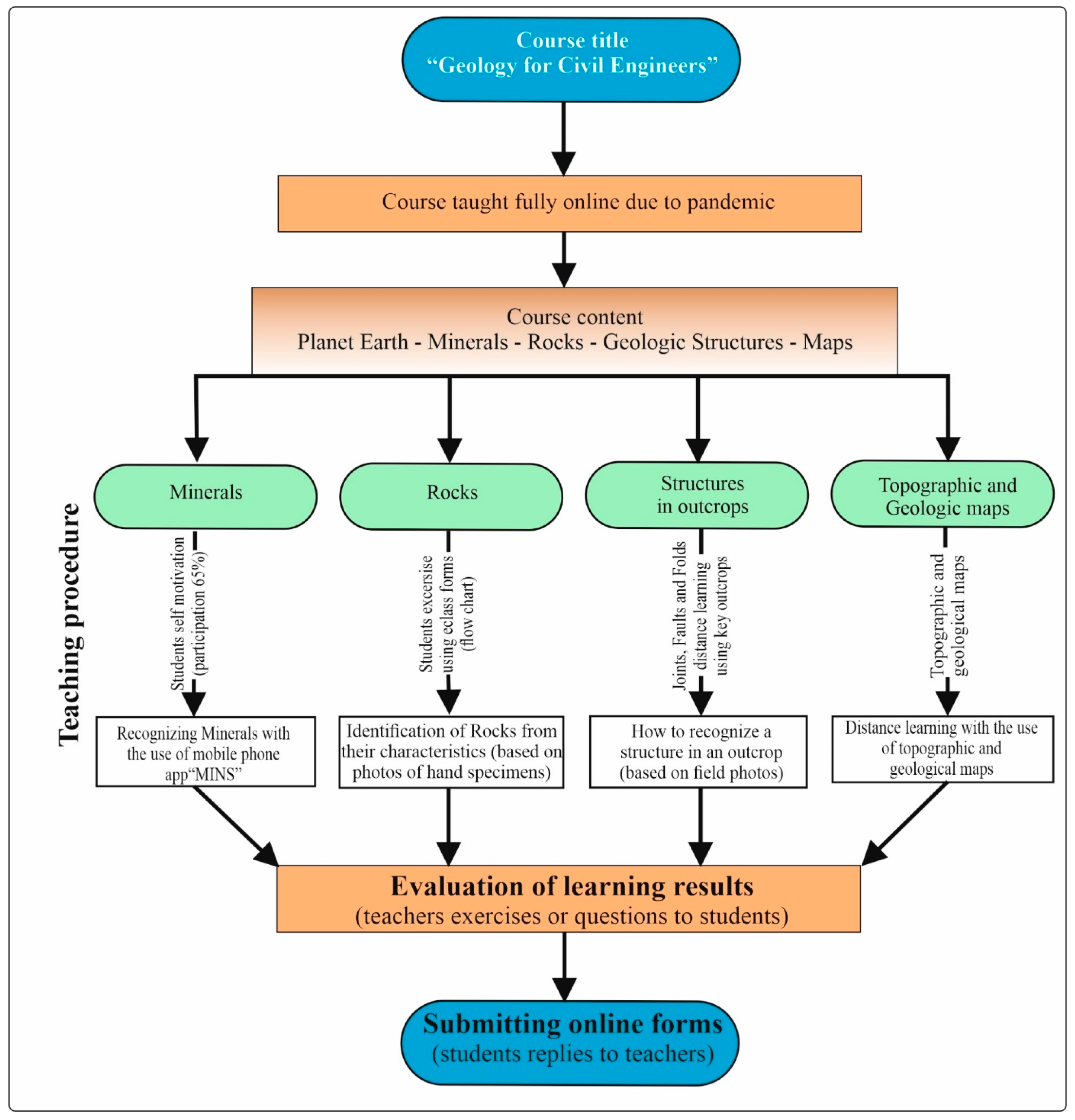
2. Materials and Methods

Interventional studies involving animals or humans and other studies that require ethical approval must list the authority that provided approval and the corresponding ethical approval code. A didactic special program was designed for a one-semester course on geology, which was conducted exclusively online and focused on the following topics: “planet earth—introduction”, “minerals”, “rocks”, “geologic structures”, and “maps”. The Intervention was based on the use of digital tools [26,27,28], such as mobile phones and mobile phone applications, including MINS [36], for mineral identification. MINS is the acronym for Mineral Identifier for Non-Specialists, and it can identify the most common minerals that exist on the upper crust of the Earth. Additionally, computer-based map exercises, flow charts, and electronically distributed exercises were designed. The didactic special program of this course lasted one semester.
A guided questionnaire was designed on the topic of “rocks” for students to practice. The same questionnaire was also given to students after the completion of the intervention to evaluate their understanding. In the case of faults and maps, an open-ended questionnaire was used as a post-course test assessment tool to evaluate students’ understanding after their participation in the intervention. The questionnaires were uploaded in Google Forms, and each one was announced to the students through the eclass platform and via email. At least 110 students participated in each questionnaire, providing the opportunity to draw conclusions from a statistically meaningful sample.

2.1. Participants

A total of 117 students participated in the questionnaire on minerals and rocks, 137 in the questionnaire on faults, and 114 in the questionnaire on maps. They were all students in the Department of Civil Engineering at the University of Patras, Greece. Their average age was 18 years and 9 months.

2.2. Procedure

Each participant, before completing the online forms, gave us permission to use and process their responses statistically in order to publish the research data, as long as all of the results are presented anonymously. Students first received introductory information regarding planet earth. The specific course was the basis for everything that followed, and the learning outcome on this topic was not evaluated separately. Afterwards, the students were instructed on minerals and rocks, then on geological structures, and finally they received information on topographic and geologic maps. After the completion of the intervention, the students completed the questionnaires and submitted the forms online (Figure 1). Detailed information regarding the procedures on the instruction of each topic is presented in Section 2.3.

2.3. Teaching Topics

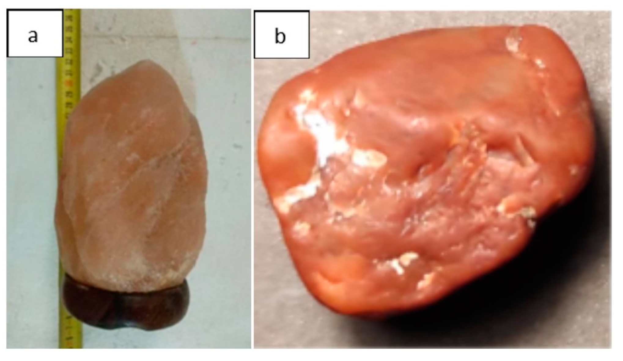
2.3.1. Teaching Mineralogy

During the spring semester of 2021, in the Department of Civil Engineering of the University of Patras, 117 freshmen participated in the course entitled “Geology for Civil Engineers” and, more specifically, the topic “minerals”. During the teaching of this specific topic, the students were given a mineral identification project. In total, 96 out of the 117 students participated in the project (participation rate: 83.47%). More specifically, students had to find minerals close to their residence—due to the COVID-19 movement ban and travel restrictions—which they would identify through the MINS application (available at Google Play: https://play.google.com/store/apps/details?id=com.minerals.identifier.mins). URL (accessed on 21 March 2023).
MINS is a mineralogical mobile phone application made specifically for university students. A user of MINS can identify (hand specimens) approximately 99% of the minerals in earth’s crust (in terms of abundance and not in the sum of minerals). This application uses specific filters, each one corresponding to a specific property, e.g., hardness. After each choice, the number of possible remaining minerals decreases, with the exception of a case in which “skip” is chosen. If the user determines all properties (or in some cases enough or even only the distinctive properties), this manipulation will lead to a successful mineral identification (1 mineral left). If the student (user) is not able to do this, then more minerals remain. In this case, the student has the choice to look and compare the characteristics of the mineral with the image of the hand specimen and read about the mineral’s properties that are provided. In this way, they may finally be able to identify the correct mineral. MINS includes 5 distinct stages: color, cleavage, hardness, luster (metallic or not), and special characteristics.
Each student had to find 3 minerals. Afterwards, based on the knowledge they had accumulated after their participation in the course on geology and, more specifically, on the topic of “minerals”, together with the use of the MINS app, they had to identify the minerals they found.

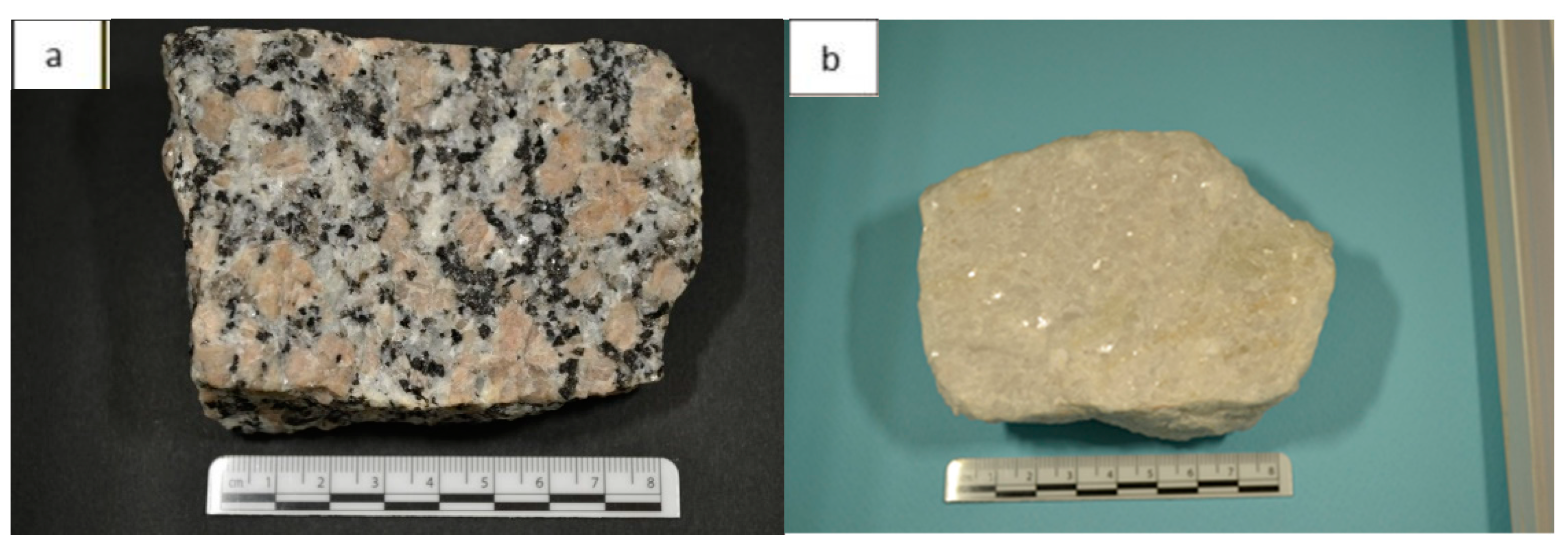
2.3.2. Teaching Petrology

Students initially received the relative theoretical information of the course. After the completion of the theoretical part of the course, the students practiced identifying rocks using a flow chart via a link that was sent to them on a synchronous e-class (https://bit.ly/petromata (accessed on 21 March 2023)) (Figures S1–S17). The students had the opportunity to finish this exercise for a week (17–24 March 2021), and afterwards the link was deactivated. After this deactivation, the students were asked to answer the same questionnaire as a test. In total, 117 students answered using the following link: https://bit.ly/petromata2021a (accessed on 21 March 2023).
The rock identification research was conducted by the professors who teach geology at the Department of Civil Engineering of the University of Patras. The specific theme of the course aimed for the students to understand the characteristics of the categories of the rocks (igneous, sedimentary, and metamorphic) and, as a result, learn how to distinguish them.
Next, they would be able to recognize the main rocks by simply observing hand specimens, and they would also be able to better comprehend the theory.

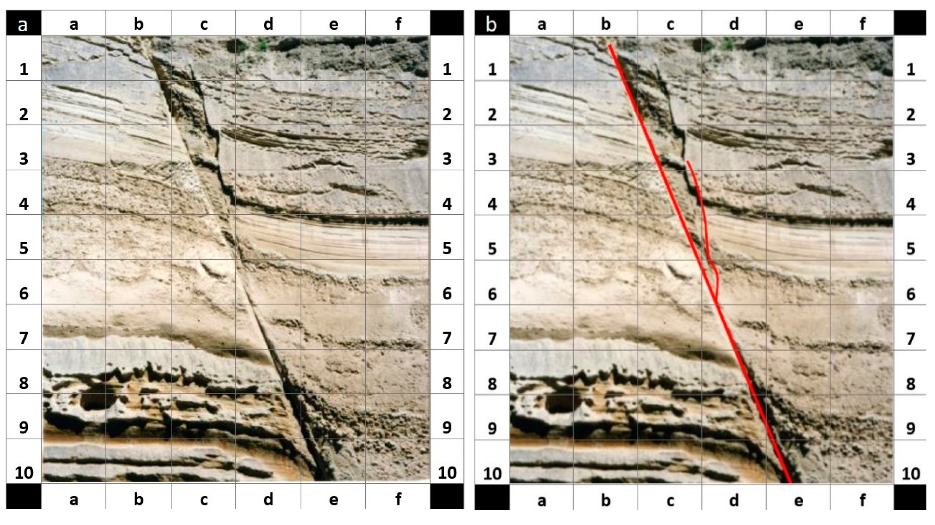
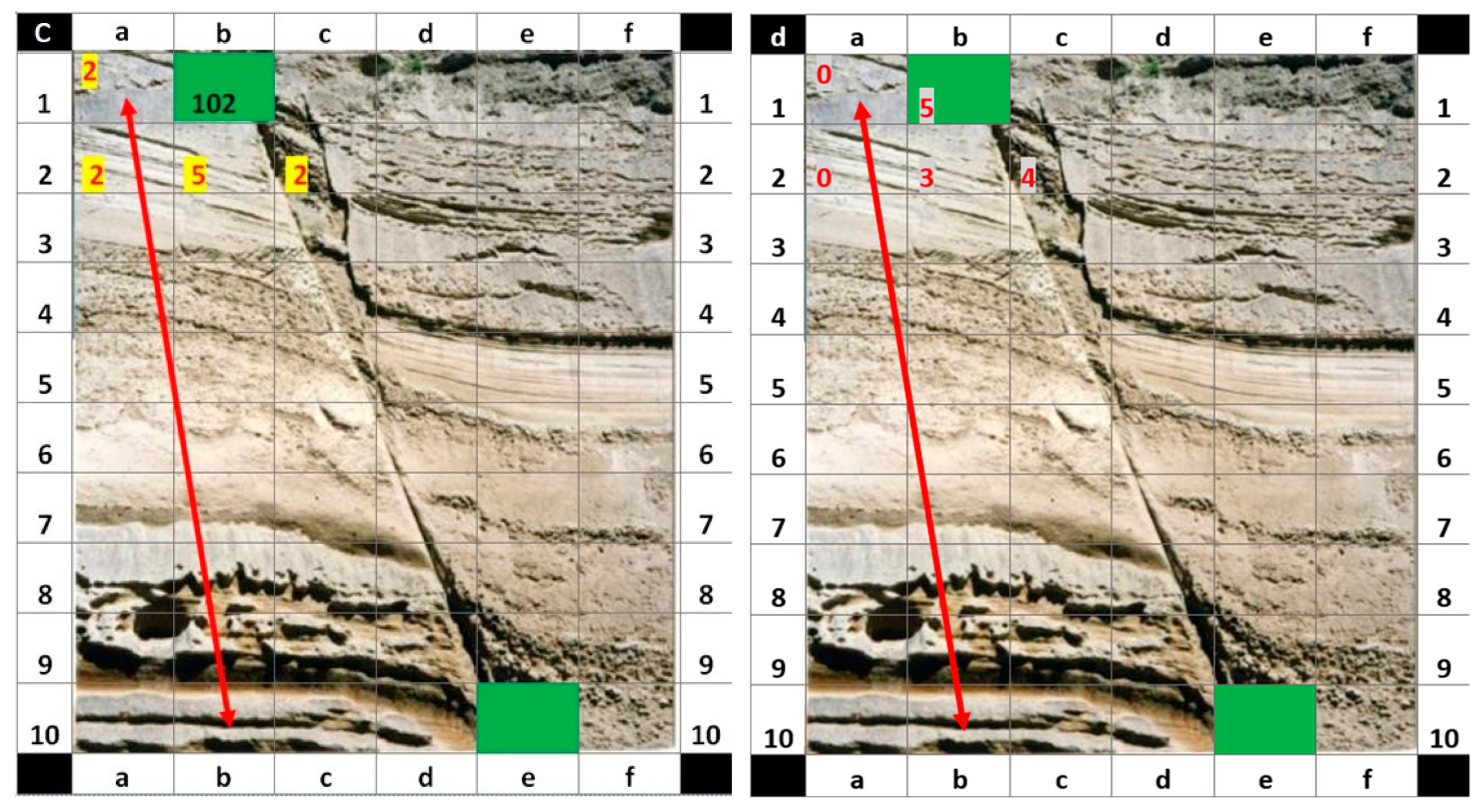
2.3.3. Faults/Tectonic Geology—Teaching Faults

A fault is a discontinuity or a zone of discontinuities between two rock blocks. Faults allow the movement or offset of two blocks relative to each other. A fault’s length and offset may range from a few millimeters to kilometers. Faults at plate boundaries are thousands of kilometers in length. In addition, faults that rupture the Earth’s surface form characteristic tectonic landforms such as fault scarps. Their significance is fundamental for miners and the petroleum industry, and they are closely associated with earthquakes. Their relationship to earthquakes adds to the idea that their recognition is significant for civil engineering students, because their presence diminishes the security of civil engineering projects.
Teaching faults is relatively simple because students need to discriminate planar structures that offset layers composing sequences. However, sometimes the understanding and definition of natural examples of faults may become complex, particularly when a fault array rather than an isolated fault crosses a large-scale outcrop or the faults affected landforms. The course on teaching faults included two 3 h lectures on fault classification and kinematics. During these lectures, we used thirty examples of outcrop photographs of faults juxtaposing layered sequences or landforms. The selection of the teaching examples included stratified sedimentary, volcano-sedimentary successions, or foliated metamorphic rocks and basin-and-range landforms controlled by faults. In these examples, the faults resulted in the separation of layers situated on the opposite blocks of one or more fault(s) or bounded basins from hills/mountains. After the completion of the lectures, the students were given a questionnaire that tested their ability at fault recognition, following the information given during the course, i.e., faults that offset a layered sequence or defined basin-and-range landforms. We applied this test through distance learning (DL) based on the use of uploaded photographs (https://bit.ly/rhgmata (accessed on 21 March 2023)). The test was announced to 137 students through an email, and 125 students completed it. The participation percentage was 91.2%. The test included a total of 18 exercises with increasing difficulty divided into two parts. On each photograph of the test, a square grid was sketched and used to denote the ends of each fault (Section 3.3). The squares were named alphanumerically. The eighteen (18) exercises were divided into two parts. The 1st part consisted of four exercises, including a question and four alternative answers, while only one was correct. The 2nd part of the test consisted of 14 exercises with a stem completing two squares of the form, i.e., a1–e4 representing the two end squares of the faults recognized on the photograph (initial square—final square or vice versa). In addition, a provision was made to accept other answers relevant to the correct one. Thus, five classes of ratings were made from 0% to 100% acceptance (Section 3.2). The students were asked to recognize in each photograph the fault or faults and then write down the squares where the ends of the fault were located. The number of faults that should be identified in each of the 14 questions are shown in Table 1.

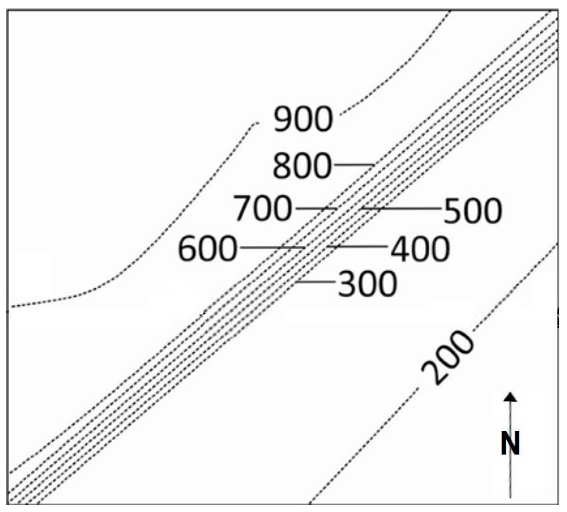
2.3.4. Teaching Maps

Learning to read a topographic map is essential. When someone is capable of correctly reading a topographic map, the map will provide a detailed understanding of the terrain they will be working on. These maps can be simple or complex, giving the students the power to visualize three-dimensional landscapes or geological structures and landscapes. These maps are conventional or aerial topographic maps and provide significant information about the landscape of a project a civil engineer is involved in. In addition, it is common practice worldwide in departments of civil engineering to learn how to read and use topographic maps. For this purpose, a course of three 3 h lectures was designed to teach the basic ideas, such as contour lines, determination of topographic features, slope inclinations, valleys definition, and other factors including water currents. After the completion of the lectures, we used as examples simple maps showing isolated landscapes such as a hill or a cliff to progressively complex landscapes showing valleys and hills. Finally, we used parts of 1:5000 scale maps showing man-made and natural features on the ground, such as roads, railways, power lines, contours, elevations, rivers, lakes, and geographical names. The second task of this topic was to understand how a simple topographic section is constructed.
After the completion of the lectures on this topic (21 April 2021), a questionnaire for the maps was given (https://bit.ly/xartes2021 (accessed on 21 March 2023)) to 127 first-year students of the Civil Engineering Department. A total of 114 completed the questionnaire (89.76% participation percentage). The questionnaire consisted of 7 multiple-choice questions of graded difficulty (from the simplest to the most complex ones). It included a series of simple landscapes and a series of topographic sections divided into two sets. In the first set, which included three exercises, the students had to correlate topographic maps with the correct topographic profiles. The second set included four questions, and the students had to recognize the correct orientation of the landscape through multiple-choice replies.

3. Results

3.1. Teaching Mineralogy

To evaluate the students’ ability to identify minerals, the students were asked to collect for themselves at least three samples of minerals that they could find near their residence (Figure 2). The students had to identify the unknown mineral samples using the mobile phone application MINS. From the examination and evaluation of the students’ reports, it was found that 25.51% of the collected samples were inappropriate. The inappropriate samples were mostly rock samples and, to a lesser degree, a few were samples from collections. The results are presented in Table 2.
From Table 2, it is evident that the participants had more correct answers than wrong answers for every property. Additionally, there were more correct mineral identifications (53.76%) than wrong (Table 2). It was observed that most of the students who gave correct answers for the properties hardness, luster, and, to a lesser degree, color, and cleavage were those that correctly identified their minerals. The highest number of correct answers were for the properties color (86.13%) and luster (77.46%). The highest number of wrong answers were for mineral identification and hardness (34.10%). The highest number of non-answered questions were, by far, for special characteristics (83.24%) and, to a lesser degree, hardness (36.42%). It should be noted here that only 1.73% of the participants provided no answer for color (Table 2).

3.2. Teaching Petrology

To evaluate the students’ ability to identify rocks, we constructed a flow chart that included the most common rock types. The results presented in Table 3 show that students had difficulty mostly in recognizing sedimentary rocks, such as mineral coals (47.06%), siltstone (45.45%), chert (22.22%), and metamorphic rocks, such as phyllite (57.00%) and gneiss (40.00%).
On the other hand, the percentages of correct answers were very high for identifying igneous rocks, such as granite (88.00%, Figure 3a), basalt (84.21%), and rhyolite (74.55%), and marble (Figure 3b), which is a metamorphic rock (92.30%). Although many students correctly identified peridotite (48.15%), a significant number of students (37.04%) confused gabbro with peridotite. In addition, they confused slate (34.62%) with phyllite (46.15%). Sandstone and conglomerate were easier for the students to recognize (59.38% and 57.14%, respectively), while it was more difficult for them to recognize limestone and chert (22.22% and 33.33%, respectively).

3.3. Teaching Faults/Tectonic Geology
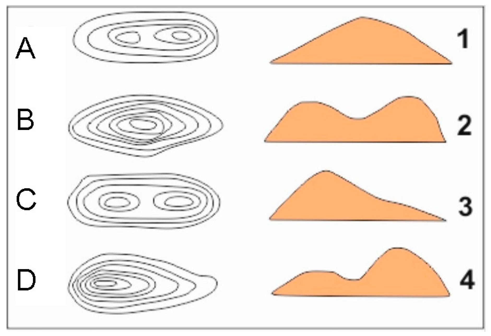
After completing the structural geology course, a questionnaire was distributed to students by email (Figures S18–S34). The test aimed to investigate whether the students recognized the faults in photographs of outcrops and landscapes (Figure 4), and then they had to write the squares where the fault began and ended. The faults that the students had to recognize ranged from the meter to the kilometer scale, and the presence of vegetation played a role in obscuring its trace. In addition, in some exercises multiple faults deformed the outcrop that the students had to recognize. In all these cases, only the correct answers are presented here and not the partially correct ones (Table 4). The results presented in Table 4 show that the response rate was up to 91.2% (125 answers, Table 4) for the simple exercises, i.e., photographs showing one fault (Figure 4). In contrast, 35% of the students responded to the complex exercises, i.e., photographs that showed more than one large-scale (km) fault affecting the landscape.
Based on a statistical analysis of the answers (Table 4), the students found it easy to recognize short faults that were meter long, exposed on outcrops with no significant erosion, and with the absence of vegetation. Typical examples of easily recognized faults are shown in exercises 1 and 3, with 81.60% and 80% correct answers, respectively. In addition, the increase in the fault length or the existence of vegetation reduced the percentage of correct answers, such as in the case of exercises 2 and 6, with 52% and 51.20% correct answers, respectively. In addition, the students failed to recognize large-scale faults controlling the landscape, such as in the case of exercises 4 and 5 (Table 4).
Surprisingly, except for the vegetation which increased the difficulty of fault recognition as expected, the students also failed to discriminate faults from sedimentary layering in the cases of urban or suburban areas and low displacement faults (exercise 0.0%, 23.20%, and 3.20%, respectively). Lastly, the most difficult task proved to be the recognition of multiple faults in large-scale vegetated landscapes.
Of particular interest, since the students’ participation was free, is their participation in the exercises (Table 4, right column, Table S1). From these data, it is clear that as the difficulty of the exercise increased, the number of surveyed students decreased. So, we consider that the high mark percentage and participation resemble the exercises’ difficulty.

3.4. Teaching Maps

After completion of the map reading course, a questionnaire was distributed to the students via email to test their understanding of how to read contour lines on topographical maps (Figures S35–S40, Figure 5 and Figure 6). The results, summarized in Table 5, show that the number of correct answers for the maps and topographic sections (exercises 1–3) was high, above 80% (Table 5). Regarding exercises 4–7, the students had low scores. These exercises asked the students to discriminate among different orientations in the inclination of the landscapes, which was a difficult task, because the students were not self-motivated to understand the role of contour lines on topographic maps, or students failed to respond to exercises 4–7 because the period between the course and the test was short. A total of 114 students participated (100%).

4. Discussion

The results of the students’ ability to identify minerals showed that only a very small number of participants gave wrong answers (14.45%), and a higher number did not answer (36.42%), indicating that they were not confident and took advantage of the option “skip” that the application offers. Despite the COVID-19 difficulties, a significant number of correct mineral identifications were observed (53.76%). Considering that the users were freshmen students of the Department of Civil Engineering, attending an introductory geology course, this number is impressively high.
According to their answers for every mineral identification property, it is evident that the most crucial properties for students to correctly identify their samples were hardness, luster, and, to a lesser degree, color and cleavage. These findings are impressive, because, indeed, the most significant properties are hardness, luster, and cleavage. Color, in many cases, is a misleading property.
The relatively low number of correct answers for cleavage needs additional explanation. However, based on the findings, it appears that cleavage is a property that needs more intensive or longer teaching, or that the DL applied under COVID-19 conditions did not allow students to understand cleavage features as much as the other properties, with which they are even more familiar from their daily life.
On the contrary, luster and special characteristics (e.g., magnetic or feels like soap) are properties for which fewer wrong answers were reported (4.62%). In the case of special characteristics, most of the students avoided answering (83.24%), and this was expected given the fact that these characteristics are found in a minority of minerals. On the contrary, in the case of luster, the high percent of correct responses was due to students’ prior knowledge (in fact, the students were familiar with metals). Therefore, it was rather easy for them to identify metallic luster. In some cases, the students correctly identified the properties but could not name the mineral because their sample was not similar to the database’s picture or had a minor color difference. This is due to the fact of their wrong belief that color is a crucial identification property. As a result, even though they should have named the mineral, they hesitated probably believing that they had made a mistake in some property.
The above results show that the learning outcomes of teaching mineralogy were satisfactory considering the lockdown and DL teaching. The results also indicate that mineralogical mobile phone applications, such as MINS, can be used by students (and teachers, too) in normal circumstances for essays after the laboratories.
The results of the students’ ability to identify rocks showed that, overall, the students seemed to recognize igneous rocks better, while they had difficulties discriminating sedimentary from metamorphic rocks. The discrimination of igneous rocks was mostly dictated by color differences, a parameter that everybody is familiar with and is rather easily observed. This is the reason why most of the wrong answers were related to color differences that were not easily observable (e.g., confused gabbro with peridotite, which is similar in color, and not granite). In addition, difficulties were observed in the discrimination between sedimentary and metamorphic rocks due to the following parameters. The discrimination of these rocks was based mostly on grain size and schistosity in metamorphic rocks and less in color. As a result, it was more demanding for students to learn the grain size limits. The fact that more properties should be considered in discriminating sedimentary from metamorphic rocks makes it challenging. There are some exceptions such as marble (metamorphic rock) or, to a lesser degree, granite (igneous rock), which most of the students could identify. The reason for this exception is that students are familiar with rocks that are commonly found in several construction materials (including ancient Greek ruins and modern constructions). Of course, this is the case for Greek students; it is rather reasonable to assume that depending on the region students could be more familiar with other rocks, e.g., in areas near Petra (Jordan), the students may be more familiar with sandstones. It is also evident that when it came to sedimentary rocks the answers were better in the case of rocks with a larger grain size, given the fact that a larger grain size can be more easily identified by the human eye.
The above findings showed that these teaching tools can be used to identify misconceptions and learning difficulties in petrology, highlighting the points that teaching rock identification should focus on in order to improve learning outcomes.
The results of the students’ ability to identify faults show that the factors that increased the difficulty were the scale of observation, vegetation, and multiple faults dissecting the outcrop. The students found it easier to identify small faults (meter long) with no significant erosion and an absence of vegetation, while they failed to recognize large-scale faults controlling the landscape or when vegetation partly obscured the fault. The students also found It difficult to discriminate faults from sedimentary layering, or stratification, and to recognize multiple faults. Overall, the number of correct answers rapidly decreased depended on the complexity of the faults’ offset layers.
It is therefore rather clear that vegetation and the existence of multiple faults reduced the ability of the students to discriminate faults. We consider that additional education (and field trips whenever possible) focusing on the above learning difficulties in the class could reinforce students’ fault recognition skills. Regarding, in general, the difficulties in recognizing faults among the students, this is not surprising, for the following reasons: (a) the structural analysis of rock outcrops is a new field for students; (b) the teaching methodology of using short courses, as explained earlier, and then testing shortly after to determine teaching outcomes is a rather intensive procedure; and (c) DL was applied unexpectedly (due to the fact of COVID-19) and both students and teachers were unprepared. As a result, the participation and interaction were not adjusted to the new DL environment. We consider that a longer teaching course will familiarize students with the issue of “faults”.
The results of the students’ ability to read topographic maps were high, above 80%. This high score is probably due to the familiarity of newer generations with thematic maps (e.g., Google Maps). On the contrary, regarding the recognition of landscapes on the maps and their orientation, the number of correct answers was significantly lower (30% to 60%). This means that a significant number of students failed to respond correctly. Although this difference was somehow unexpected given the high score for exercises 1–3, it can be explained based on the increasing urbanism of the students and the difficulty in recognizing landscapes based on maps, which is a 3D problem. This is probably because recognizing 3D counterparts of topographic maps, such as landscapes, is not a trivial procedure but needs further teaching. In addition, the familiarity of newer generations with maps might not be a significant help in such complex problems. In any case, additional teaching focusing on these learning difficulties caused by DL education could reinforce the students’ skills. In this direction, multisensory instruction contributes added value regarding better outcomes on learning and motivation [37]. Moreover, some of the reasons like those provided for the structural course are also applicable here. In particular, teaching problems on map reading prior to COVID-19 was supported with the face-to-face supervision of the solutions to the map exercises in the classroom.
In summary, the teaching of faults and maps would have been more effective if the amount of time was longer and discussion between students and teachers increased. Of course, we consider that, alternatively, field trips could have been taken to support the teaching in the classroom. Then, we consider that many incorrect answers would be omitted from the current results, and the teaching outcomes would be higher. However, due to the lockdown, this was not possible. Nevertheless, it is reasonable to suggest that the above-spotted learning difficulties could help identify appropriate locations (more difficult to identify or understand) for planning successful field trips in the future.

5. Conclusions

To minimize the impact of the COVID-19 pandemic, several innovative DL techniques in teaching geology were applied to a university class of more than 100 students. The evaluation of the learning outcomes showed their positive impact on learning basic concepts of geology and, more, specifically “minerals”, “rocks”, “faults”, and “topographic maps”. Thus, it is suggested that these techniques, such as mineralogical mobile phone applications and rock identification flow charts, could be applied in DL education, but they can also be used as tools to enhance learning outcomes in normal conditions.
At the same time, learning difficulties were identified from the results of the study. More specifically, misconceptions in the property of “cleavage” shows that additional teaching is needed to explain minerals’ cleavage. Additionally, many students wrongly believed that a minor color difference indicates a different mineral. Sedimentary and metamorphic rocks were more difficult for the students to distinguish than igneous rocks, and teachers should focus on this. The geology of the area where the students live is considered important for the specific minerals and rocks they learn about, especially in cases of “famous” rocks or rocks that are used as construction materials. In addition, teaching needs were detected for complex fault identification exercises involving more than one fault, vegetation that obscured the fault trace, or when the faults dissected a large-scale rock outcrop. Finally, due to the limitations of DL, students failed to recognize landscapes from maps.
Following the results of the present study, it is suggested that fault and map teaching could be more effective if fieldtrips take place in locations where the abovementioned difficulties are indicated or if the course is lengthened. This way, students could be familiarized with difficult geological issues. At the same time, it is suggested that the innovative teaching tools constructed for this study could be used combined with laboratories and fieldtrips for better learning outcomes.

Supplementary Materials

The following supporting information can be downloaded at: https://www.mdpi.com/article/10.3390/geosciences13040096/s1.

Author Contributions

Conceptualization, D.P., I.K. and I.S.; Data curation, G.G.; Formal analysis, P.E. and G.G.; Funding acquisition, I.K. and D.P.; Investigation, I.K., D.P. and G.G.; Methodology, D.P., I.K. and I.S.; Project administration, D.P., I.K. and I.S.; Resources, D.P. and I.K.; Supervision, D.P., I.K., I.S. and G.G.; Validation, D.P., I.K., I.S., P.E., E.G. and G.G.; Visualization, D.P., I.K., I.S., P.E., E.G. and G.G.; Writing—original draft, G.G., D.P., I.K., I.S., P.E. and E.G.; Writing—review and editing, D.P., I.K. and I.S. All authors have read and agreed to the published version of the manuscript.

Funding

This research received no external funding.

Institutional Review Board Statement

Not applicable.

Informed Consent Statement

Not applicable.

Data Availability Statement

The data presented in this study are available upon request from the corresponding author.

Conflicts of Interest

The authors declare no conflict of interest.

References

  1. Boatright, D.; Davies-Vollum, S.; King, C. Earth science education: The current state of play. Geoscientist 2019, 29, 16–19. [Google Scholar] [CrossRef]
  2. Giles, S.; Jackson, C.; Stephen, N. Barriers to fieldwork in undergraduate geoscience degrees. Nat. Rev. Earth Environ. 2020, 1, 77–78. [Google Scholar] [CrossRef] [Green Version]
  3. Plenge, M.F.; Hutson, B.L.; Graniero, L.E. The BeAMS project: Using inquiry and modeling to introduce students to the research process in an introductory geology laboratory. J. Geosci. Educ. 2021, 70, 368–383. [Google Scholar] [CrossRef]
  4. Giotopoulos, G.; Skopeliti, I.; Koukouvelas, I.; Economou, P.; Gianni, E.; Papoulis, D. Civil engineering students’ misconceptions on principles of geology. In Proceedings of the 22nd International Multidisciplinary Scientific GeoConference Surveying, Geology and Mining, Ecology and Management, SGEM, Albena, Bulgaria, 10 July 2022; Volume 22, pp. 735–741. [Google Scholar] [CrossRef]
  5. Katrivanos, E.; Makri, K. Detection of the perception of students of Geology on the theory of tectonic plates. Bulletin of the Geological Society of Greece. In Proceedings of the 12th International Congress, Patrai, Greece, 20–22 May 2010. [Google Scholar]
  6. Peace, A.L.; Gabriel, J.J.; Eyles, C. Geoscience Fieldwork in the Age of COVID-19 and Beyond: Commentary on the Development of a Virtual Geological Field Trip to Whitefish Falls, Ontario, Canada. Geosciences 2021, 11, 489. [Google Scholar] [CrossRef]
  7. Pasquaré Mariotto, F.; Venturini, C. Strategies and tools for improving Earth Science education and popularization in museums. Geoheritage 2017, 9, 187–194. [Google Scholar] [CrossRef]
  8. Venturini, C.; Pasquaré Mariotto, F. Geoheritage promotion through an interactive exhibition: A case study from the Carnic Alps, NE Italy. Geoheritage 2019, 11, 459–469. [Google Scholar] [CrossRef]
  9. Wang, C.; Pan, R.; Wan, X.; Tan, Y.; Xu, L.; McIntyre, R.S.; Ho, C. A longitudinal study on the mental health of general population during the COVID-19 epidemic in China. Brain Behav. Immun. 2020, 87, 40–48. [Google Scholar] [CrossRef]
  10. Hodges, C.; Moore, S.; Lockee, B.; Trust, T.; Bond, A. The Difference Between Emergency Remote Teaching and Online Learning. EDUCAUSE Rev. 2020. Available online: https://er.educause.edu/articles/2020/3/the-difference-between-emergency-remote-teaching-and-online-learning#fn3 (accessed on 21 March 2023).
  11. Iglesias-Pradas, S.; Hernández-García, Á.; Chaparro-Peláez, J.; Prieto, J.L. Emergency remote teaching and students’ academic performance in higher education during the COVID-19 pandemic: A case study. Comput. Hum. Behav. 2021, 119, 106713. [Google Scholar] [CrossRef]
  12. Anthony Jnr, B.; Noel, S. Examining the adoption of emergency remote teaching and virtual learning during and after COVID-19 pandemic. Int. J. Educ. Manag. 2021, 35, 1136–1150. [Google Scholar] [CrossRef]
  13. Hodges, C.B.; Moore, S.L.; Lockee, B.B.; Aaron Bond, M.; Jewett, A. An Instructional Design Process for Emergency Remote Teaching; Springer: Singapore, 2021. [Google Scholar] [CrossRef]
  14. Skulmowski, A.; Rey, G.D. COVID-19 as an accelerator for digitalization at a german university: Establishing hybrid campuses in times of crisis. Hum. Behav. Emerg. Technol. 2020, 2, 212–216. [Google Scholar] [CrossRef] [PubMed]
  15. Vlasova, M. E-learning implementation for geoscience students. In Proceedings of the International Multidisciplinary Scientific GeoConference Surveying Geology and Mining Ecology Management, SGEM, Albena, Bulgaria, 17–26 June 2014; Volume 3, pp. 591–595. [Google Scholar] [CrossRef]
  16. Sit, S.M.; Brudzinski, M.R. Creation and assessment of an active e-learning introductory geology course. J. Sci. Educ. Technol. 2017, 26, 629–645. [Google Scholar] [CrossRef]
  17. Adedoyin, O.B.; Soykan, E. COVID-19 pandemic and online learning: The challenges and opportunities. Interact. Learn. Environ. 2020, 1–13. [Google Scholar] [CrossRef]
  18. Caruana, D.J.; Salzmann, C.G.; Sella, A. Practical science at home in a pandemic world. Nat. Chem. 2020, 12, 780–783. [Google Scholar] [CrossRef]
  19. Cockett, R.; Moran, T.; Pidlisecky, A. Visible geology: Creative online tools for teaching, learning, and communicating geologic concepts. AAPG Bulletin 2016. [Google Scholar] [CrossRef]
  20. Bonali, F.L.; Russo, E.; Vitello, F.; Antoniou, V.; Marchese, F.; Fallati, L.; Bracchi, V.; Corti, N.; Savini, A.; Whitworth, M.; et al. How Academics and the Public Experienced Immersive Virtual Reality for Geo-Education. Geosciences 2022, 12, 9. [Google Scholar] [CrossRef]
  21. Lockee, B.B. Online education in the post-COVID era. Nat. Electron. 2021, 4, 5–6. [Google Scholar] [CrossRef]
  22. d’Alessio, M.A.; Lundquist, L.L.; Schwartz, J.J.; Pedone, V.; Pavia, J.; Fleck, J. Social presence enhances student performance in an online geology course but depends on instructor facilitation. J. Geosci. Educ. 2019, 67, 222–236. [Google Scholar] [CrossRef]
  23. d’Alessio, M.A.; Schwartz, J.J.; Pedone, V.; Pavia, J.; Fleck, J.; Lundquist, L. Geology goes Hollywood: Building a community of inquiry in a fully online introductory geology lecture and laboratory. J. Geosci. Educ. 2019, 67, 211–221. [Google Scholar] [CrossRef]
  24. UNESCO Institute for Statistics Data. COVID-19 Impact on Education; UNESCO: Paris, France, 2020; Available online: https://en.unesco.org/covid19/educationresponse (accessed on 12 February 2023).
  25. Owusu-Fordjour, C.; Koomson, C.K.; Hanson, D. The Impact of COVID-19 on Learning–The Perspective of the Ghanaian Student. Eur. J. Educ. Stud. 2020, 7, 88–101. [Google Scholar] [CrossRef]
  26. Adel, A.; Dayan, J. Towards an intelligent blended system of learning activities model for New Zealand institutions: An investigative approach. Humanit. Soc. Sci. Commun. 2021, 8, 72. [Google Scholar] [CrossRef]
  27. Perevalova, A.; Resenchuk, A.; Tunyova, N. Teaching professional vocabulary to the students in coal region universities through digital educational tools. In Proceedings of the E3S Web of Conferences, Online, 27 May 2020; p. 174. [Google Scholar] [CrossRef]
  28. Sebastián-López, M.; González, R.M. Mobile learning for sustainable development and environmental teacher education. Sustainability 2020, 12, 9757. [Google Scholar] [CrossRef]
  29. Rasheed, R.A.; Kamsin, A.; Abdullah, N.A. Challenges in the online component of blended learning: A systematic review. Comput. Educ. 2020, 144, 103701. [Google Scholar] [CrossRef]
  30. Favale, T.; Soro, F.; Trevisan, M.; Drago, I.; Mellia, M. Campus traffic and e-learning during COVID-19 pandemic. Comput. Netw. 2020, 176, 107290. [Google Scholar] [CrossRef]
  31. Aristovnik, A.; Keržič, D.; Ravšelj, D.; Tomaževič, N.; Umek, L. Impacts of the COVID-19 pandemic on life of higher education students: A global perspective. Sustainability 2020, 12, 8438. [Google Scholar] [CrossRef]
  32. Karalis, T.; Raikou, N. Teaching at the Times od COVID-19: Inferences and Implications for Higher Education Pedagogy. Int. J. Acad. Res. Bus. Soc. Sci. 2020, 10, 479–493. [Google Scholar] [CrossRef]
  33. Araújo, F.J.D.O.; de Lima, L.S.A.; Cidade, P.I.M.; Nobre, C.B.; Neto, M.L.R. Impact of SARS-CoV-2 and its reverberation in global higher education and mental health. Psychiatry Res. 2020, 288. [Google Scholar] [CrossRef] [PubMed]
  34. Pizarro-Ruiz, J.P.; Ordóñez-Camblor, N. Effects of COVID-19 confinement on the mental health of children and adolescents in Spain. Sci. Rep. 2021, 11, 11713. [Google Scholar] [CrossRef] [PubMed]
  35. Kruchinina, G.A.; Tararina, L.I.; Sokolova, E.E.; Limarova, E.V.; Muskhanova, I.V.; Arsaliyev, S.M.; Bazayeva, F.U.; Tagirova, N.P. Information and communication technologies in education as a factor of students’ motivation. Int. Rev. Manag. Mark. 2016, 6 (Suppl. 2), 104–109. [Google Scholar]
  36. Papoulis, D.; Gianni, E.; Karampasi, A. Mins (Mineral identifier for non-specialists): A new mineralogical application for mobile phones. In Proceedings of the International Multidisciplinary Scientific GeoConference Surveying Geology and Mining Ecology Management, SGEM, Online, 1–10 July 2019; Volume 19, pp. 207–214. [Google Scholar]
  37. Ferreira, F.M.; Vasconcelos, C. The Impact of Multisensory Instruction on Geosciences Learning and Students’ Motivation. Geosciences 2020, 10, 467. [Google Scholar] [CrossRef]
Figure 1. Flow chart of teaching geology under DL.
Geosciences 13 00096 g001
Figure 2. Sample photographs of minerals found by the students: (a) halite; (b) hematite.
Geosciences 13 00096 g002
Figure 3. (a) Granite; (b) marble.
Geosciences 13 00096 g003
Figure 4. (a) Exercise 1 of the questionnaire. The photo shows a fault plane that offsets sediments in the Corinth Canal, Greece. The fault deforms the sediments to a normal drag fold since the almost horizontal sedimentary succession is warped in the transport direction of the fault. (b) The red line highlights the initial and end point of the fault in the outcrop. The correct answer is b1–e10 or e10–b1. These answers corresponded to 5 marks. (c) Summary of the answers given numerically by the students. (d) Answers as given by the students as marked from 1 to 5.
Geosciences 13 00096 g004aGeosciences 13 00096 g004b
Figure 5. Example of an exercise where the students had to match the letter and number or the topographic map and the topographic section. The correct answers are A4, B1, C2, and D3.
Geosciences 13 00096 g005
Figure 6. Example of an exercise. A precipice is shown on a piece of topographic map. The students had to choose the correct answer regarding its orientation on the map. The choices were (a) N–S; (b) E–W; (c) NW–SA; (d) NE–SW. The correct answer is (d) NE–SW.
Geosciences 13 00096 g006
Table 1. Number of faults to identify in each question.
Exercise’s NumberNumber of Faults
11
21
31
42
52
61
71
81
91
102
112
122
133
144
Table 2. Percentage of wrong and correct answers in each stage after the MINS application, commenting only on the percentage of accepted answers.
Steps of MINS ApplicationDescription of Each StepCorrect AnswersWrong AnswersNot Answered (Skip)
1stColor86.13% 12.14%1.73%
2ndCleavage48.55%14.45%36.42%
3rdHardness49.13%34.10%16.76%
4thLuster77.46%4.62%17.92%
5thSpecial characteristics12.14%4.62%83.24%
6thName53.76%36.99%9.25%
Table 3. Percentage of correct answers in the rock identification.
Igneous RockSedimentary RockMetamorphic Rock
granite88.00%sandstone59.38%marble92.30%
basalt84.21%conglomerate57.14%quartzite69.80%
rhyolite74.55%mineral coals47.06%phyllite57.00%
diorite72.73%Siltstone45.45%biotite gneiss40.00%
peridotite60.00%limestone33.33%slate34.62%
gabbro48.15%chert22.22%
Table 4. Summary of the answers of the students corresponding to each image and the percentage.
ExerciseItems Description0 Mark1 Mark2 Marks3 Marks4 Marks5 MarksHigh Marks
Percentage
Surveyed Students Per Exercise
1A m long fault2025210281.60%113
2A km long fault565606552.00%87
3A m long fault0250210080.00%109
4Two km long faults in a vegetated landscape1801012800.00%48
5Two km long faults330263500.00%76
6A m long fault 700396451.20%83
7A km long fault in a vegetated landscape90055191612.80%99
8A km long fault 4400181800.00%80
9A km long fault40410354435.20%97
10Two m long faults2600002923.20%55
11Two m long faults6000414737.60%94
12Two m long faults330002143.20%58
13Three m long faults, in a vegetated outcrop9063093931.20%93
14Four m long faults, in a vegetated outcrop3020694636.80%93
Table 5. Summary of students’ answers on the maps questionnaire.
ExerciseItemsNumber of Correct AnswersCorrect Answers PercentageNumber of Wrong AnswersWrong Answers Percentage
1Matching the pieces of the maps with the topographic sections11096.50%43.50%
2Matching the pieces of the maps with the topographic sections10592.10%97.90%
3Recognizing a hill on a topographic map9280.70%2219.30%
4Recognizing a slope on a topographic map7061.40%4438.60%
5Finding the inclination of a steep slope on a topographic map4741.20%6758.80%
6Recognizing different landscapes, valleys, and hills on a topographic map/topographic section 3328.90%8171.10%
7Finding the orientation of a steep slope on a topographic map4539.50%6960.50%
Disclaimer/Publisher’s Note: The statements, opinions and data contained in all publications are solely those of the individual author(s) and contributor(s) and not of MDPI and/or the editor(s). MDPI and/or the editor(s) disclaim responsibility for any injury to people or property resulting from any ideas, methods, instructions or products referred to in the content.

