1. Introduction
Greece is one of the few regions on earth where geology has been the most important factor in shaping its unique and beautiful natural environment, as well as its social, economic and historical development from ancient times to the present day.
Indeed, complex geological processes are responsible for the genesis and evolution of the unique island complexes, the many kilometres of coastline and the landscapes of unusual beauty, for the unique climate conditions, for the soil which supports a wide variety of flora and fauna, for the mineral raw materials and, of course, for its culture. As a result, there has been a strong scientific movement in Greece in recent years to evidence its geological heritage and to manage its geosites (e.g., [
1,
2,
3,
4,
5]), with studies aimed at recording geotopes in specific areas that represent important moments in the history of the country and our planet.
Furthermore, the emergence of another, alternative form of tourism, geotourism, has gained its own momentum and is seeking its own share in the country’s economy. Geotopes, Geoparks and Natural History Museums are the best fields for geotourism activities and, therefore, geotourism could be an important opportunity for local community development and sustainability [
6,
7,
8,
9].
Geotourism is a “new” challenge, not only because it can redistribute the country’s tourism products in areas that have not been tourist destinations to date, but also because it can create a new quality of tourist stream in the country.
Although, the term “urban geotourism” is relatively new, the use of geology, geomorphology and other associated man-made activities and features (building stones or anthropogenic landforms) within urban areas for tourism and education is much older.
Del Lama [
10] defines urban geotourism as tourism in places anywhere within the boundaries of a city (whether in the form of built heritage or geological formations) related to geological concepts and characteristics. As evidenced by numerous publications and books from various parts of the world with diverse cultural and social environments, the number of studies highlighting the use of geodiversity and geological heritage in urban areas is growing, yet mainly focuses on European cities. The rest of the world remains rather “unexplored” in this respect [
11,
12].
Urban geodiversity is defined by Palacio-Prieto [
13] as “buildings and other man-made features of the city that developed under specific geological conditions or that have undergone specific geological processes over time”. Such anthropogenic geodiversity elements can be beneficial to community cultural development, leading to the conclusion that cultural heritage associated with the abiotic, natural environment can be treated as a component of geocultural diversity and included in the urban geodiversity typology.
There are several classifications of urban geodiversity, but we focus on the one developed by Habibi et al. [
11], who distinguished between in situ and ex situ geodiversity, which is consistent with other classifications [
14] that include both in situ and displaced geodiversity features, such as those held in museum collections or used as building/decorative stones.
An “urban geotope” is defined as a place of geological or geomorphological interest within a city [
15]. This location can be natural, originating from geological processes, or it can be the result of artificial constructions where characteristic rock types were used for their construction [
13,
16]. Urban geotopes highlight the relationship between geology-geomorphology and society. They are preserved not only because of their geological value, but also for aesthetic, cultural and economic reasons.
Urban geotopes usually occupy small territorial areas and their location depends on the size of the city, and its population, as well as its spatial structure. Therefore, only a few urban geoparks exist in the center of cities, while many of them are located on the outskirts of cities where there are more open spaces. As a result of their locations, they are more affected by anthropogenic activity, especially by urbanization. Some scholars refer to anthropogenic pressure to describe the urgency and necessity of their conservation [
17].
In recent years, examples of geotourism with urban characteristics (urban geotourism) have appeared in many countries around the world, such as Brazil [
18], which combines geological heritage with cultural heritage [
19].
Athens, the capital of Greece, combines history and the past with modern reality. There are numerous archaeological and historical monuments which constitute the cultural wealth of the city. To these cultural monuments should also be added the geological monuments, which constitute the natural heritage of the country.
The city, although it gathers several important inherent advantages (such as archaeological sites, cultural heritage, and climatic conditions), fails to show itself as an attractive city break destination, mainly due to its functional disadvantages (it is not a tourist-friendly city, there is traffic congestion, high costs, an unattractive urban landscape, an absence of large conference spaces, etc.) and its lack of promotion. Whilst points of interest located in the area do exist, there is a decline in Attica’s position in the tourism sector [
20].
However, especially for Athens, the potential of dynamic tourism development remains extremely favorable. The promotion of the geo-cultural heritage of the city, which is directly related to the preservation and protection of the environment, can strengthen and diversify the development of tourism, identity, culture, and interests of the local population.
The well-known Acropolis is an ancient temple complex standing atop a rocky outcropping in the heart of Athens. The Acropolis of Athens is one of the most impressive and recognizable monuments in the world, world-renowned and of exceptional archaeological, historical, and touristic value. At the same time, however, the Acropolis Rock is also an admirable monument of geological heritage. Unfortunately, only a few people know that there are numerous and varied urban geosites within the sacred rock of Acropolis, reflecting its natural and cultural heritage, showing the connection between geology, geomorphology, and urban development, and which are interesting geotourist objects.
In this paper, we will deal with the monuments of the Acropolis, which, apart from their cultural value, are of high geological interest. The geotouristic potential of the city of Athens is highlighted through the identification and quantitative assessment of these geosites. The main goal of this assessment is to select the geosites that combine the best conditions for use in environmental education and that also have a high value for urban geotourism, due to their intrinsic value as representative geological sites, their connection with environmental issues (pollution, climate change, natural hazards, waste, and recycling, among others), and their accessibility conditions. The result of our study not only helps in scaling the regional tourism industry, adding value to tourism, but also reveals the geodiversity of the area, aiming at its geoconservation.
2. Material and Methods
The identification and assessment of geosites for geotourism was based on fieldwork and a detailed review of published literature and maps (both contemporary and historic). It not only focused on the traditionally accepted characteristics of geodiversity, but also covered aspects reflecting the interactions between geodiversity and culture.
According to today’s holistic concept of geotourism, the inventory of geotourism resources should consider the following: (1) the natural features, geological, geomorphological, hydrological or paleontological, and ecological elements related to geodiversity and (2) the cultural aspects related to geodiversity and geographical heritage, e.g., churches and cemeteries, pavements and stone buildings or toponyms associated with geodiversity (e.g., [
21]).
Particular attention was paid to anthropogenic landforms, which are of high interest, are very common in urban areas and have high potential for geotourism and education [
22].
2.1. The City of Athens
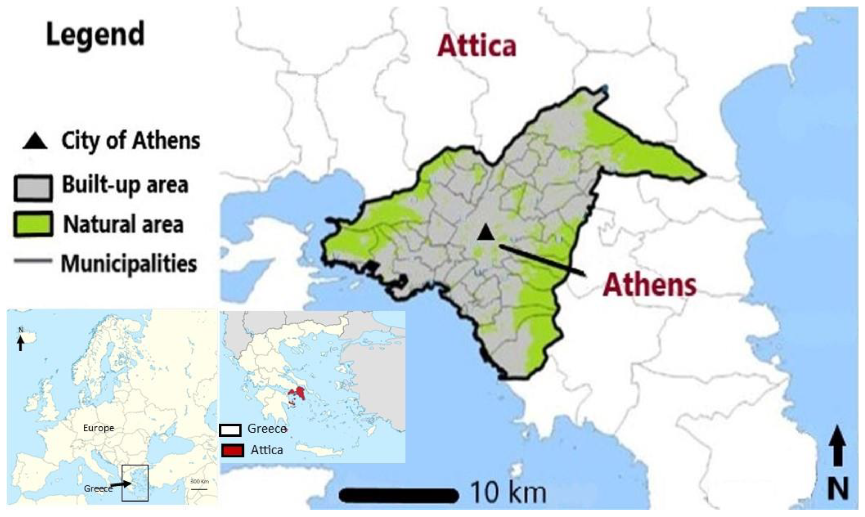
Attica is one of the 13 regions of Greece and includes the Prefecture of Athens, which is the capital of the Attica region and of Greece (
Figure 1).
Athens is a heavily urbanized area with severe traffic problems, both in the city center and in its harbour, Piraeus. The settlement of Athens covers a total area of 414.6 km2, including the entire city of Athens and the harbour of Piraeus, as well as its suburbs. It has a subtropical Mediterranean climate with mild winters and hot, dry summers.
In the first post-war decades, a rapid concentration of the population took place in the central and western parts of the city. Since the mid-1970s, urbanization has shifted to the suburbs in the northeast and southeast. Unlike most European capitals, the urbanization of modern Athens is not related to the industrial revolution.
The city’s population grew rapidly from 400,000 people in 1925 to about 1,000,000 by 1950. The population growth of modern Athens was due to the return of Greek refugees from Asia Minor in the 1920s after World War I and extensive internal migration after World War II.
Today, the urban areas of Athens and Piraeus have a population of approximately 3.2 million inhabitants in an area of 412 km2. This number corresponds to approximately 1/3 of the Greek population. The Attica region is home to nearly half of Greece’s population, more than 60% of the country’s industrial production, as well as high-value real estate and infrastructure. The population density (people per km2) is about 7500 and over 20,000 in some municipalities with a high frequency of residential, commercial, and business activities. There is no large-scale industry in Athens. Several industrial support services, including warehouses, commercial transport companies, and building materials yards, are located between Athens Center and Piraeus. Earlier industries in recent decades produced ceramics, textiles, footwear, and engaged in tanning and metallurgy.
Athens is mainly known for its ancient history and especially for the Golden Age of Pericles in 500 BC. Under his rule, Athens became the most powerful city-state in Greece. His main contribution was, of course, the establishment of democracy. Athens became the intellectual and artistic center of the ancient world. Among all other things, Pericles was also responsible for the construction of the Parthenon.
2.2. Geology–Geomorphology
The basin of Attica, also known as the basin of Athens, or the Athenian plain, is about 22 km long from NE to SW and 11 km wide across, and includes Athens, Piraeus and the municipalities of their surrounding suburbs. It is the most densely populated region of Greece. It is a large tectonic depression running NNE-SSW, bounded by Parnitha to the northwest, Pendeli to the northeast, Aegaleo and Poikilo to the west and Hymettus to the east, while the Saronikos Gulf opens up to the southwest (
Figure 2).
Inside the basin, a series of hills, the altitudes of which decreases towards the SW, has developed along the central axis in a NE-SW direction (
Figure 3). The main ones, from north to south, are the Tourkovounia (339 m), Lykabettus (278 m), the Acropolis (156 m) and the Museum Hill or Filopappou (147 m), all made of a lowermost Upper Cretaceous (100 My) limestone, called locally the “Tourkovounia Formation” [
24]. These hills have the same geological age and the same geological structure as the Acropolis hill.
The four hills located on the surface of the basin are rocky remnants of a previous relief and are characterised as “inselberg hills,” i.e., isolated hills [
25]. There are also smaller ones, such as Ardittos (131 m), Strefi Hill, the Hill of the Nymphs, and Areios Pagos.
Pliocene marine deposits have been detected west of Lycabettus at a height of 120 m [
26,
27] and in the western part of Hymettus. In the area of Tourkovounia, clay deposits were found in the cracks and fractures of limestones, which chronologically belong to the Pleistocene [
28].
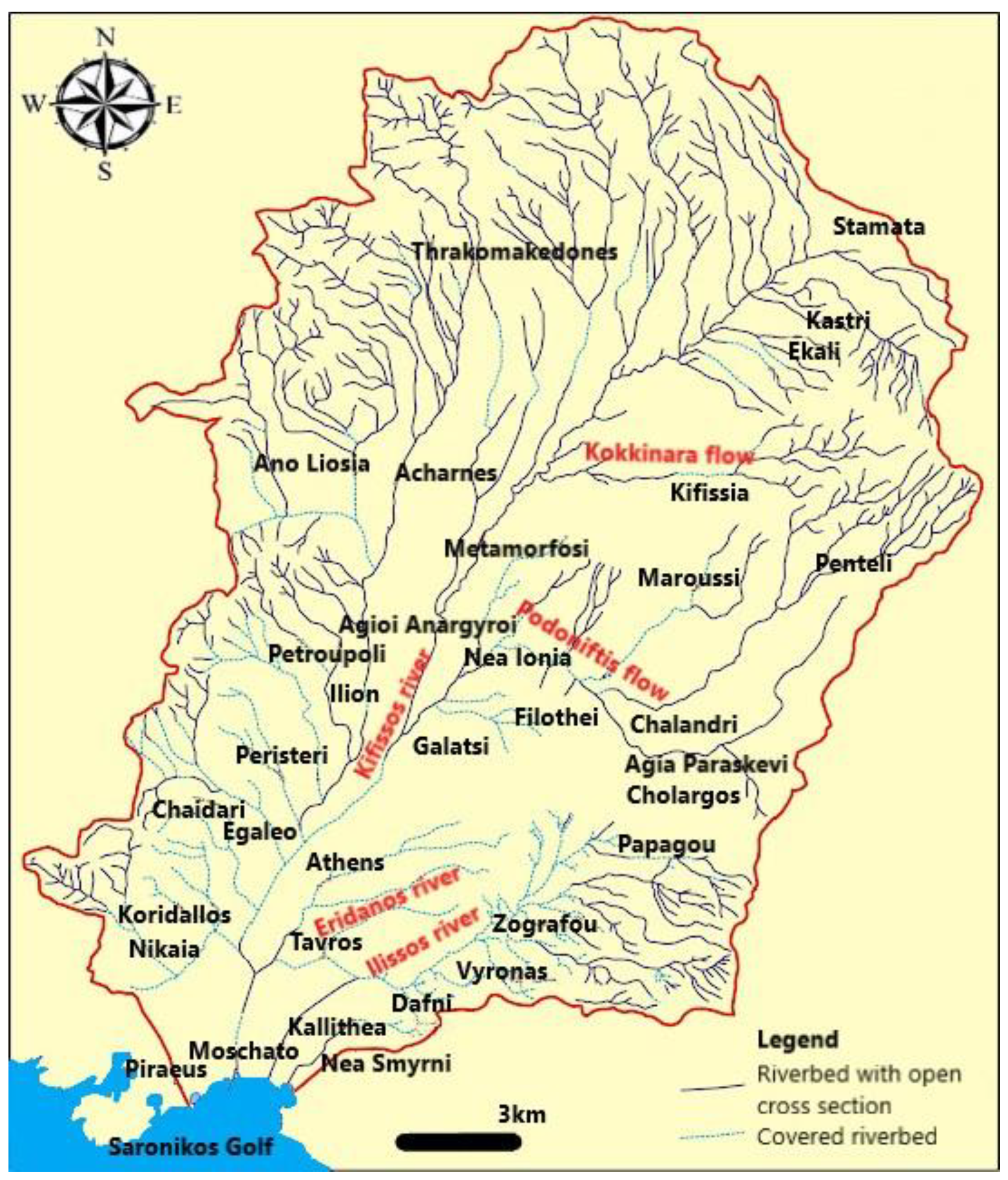
The Attica basin is drained by two main hydrographic networks, the Kifissos and the Ilissos (
Figure 4). Both hydrographic networks are characterised by the existence of mainly small and seasonal streams. Kifissos is the largest river in the region, 27 km long, originating from western Pendeli and southern Parnitha, flowing through the basin in a N-S direction into the bay of Faliro. Most of the river’s route was formed by the mid-20th century into an open channel, which was later covered by the national highway A1, meaning that the Kifissos River has been largely modified and covered by the continuous development of the urban fabric [
29]. Ilissos originates from Hymettus and also flows into Faliro bay (
Figure 4).
Since the mid-18th century, several researchers have studied the geological setting of the Athens area [
31,
32,
33,
34,
35,
36,
37,
38]. Despite this, the understanding of Athens’ lithostratigraphic structure remains incomplete.
The Attica Basin was formed during the Alpine orogeny. It is located in the back-arc area of the Hellenic Arc and comprises Alpine basement rocks, both metamorphic and non-metamorphic, and post-Alpine sediments (
Figure 2). The alpine formations today form the mountains that surround the basin, as well as the hilly area in its centre (Filopappou, Acropolis, Lycabettus, Tourkovounia, etc.), while the post-alpine sediments, i.e., the sediments that have been deposited in the Athens basin after the uplift of the mountains, come mainly from the erosion of the latter.
The main rocks that make up the uplifted alpine formations are as follows:
The limestones of the western mountains (Aegaleo, Poikilo Oros, Parnitha). These are rocks formed about 200 million years ago, from deposits in a marine environment, indicating that the area was once a large ocean.
The metamorphic rocks of the eastern mountains (Hymettus, Pendeli). These are rocks that were metamorphosed under conditions of high pressure and temperature. The main ones are marbles (an example is the well-known Pendelic marble) and schists.
The “Athens schists”, as they have come to be called, albeit somewhat misleadingly, because, in reality, they are a complex system of different rocks (pelites, argillaceous shales, marls, sandstones), formed on the sea bed during the uplift of the mountain ranges mentioned above. The Athens schists are overlain, in some places, by relatively young limestone, forming hilltops (e.g., Acropolis, Lycabettus, Tourkovounia).
2.3. The Geology and Geomorphology of the Acropolis Hill
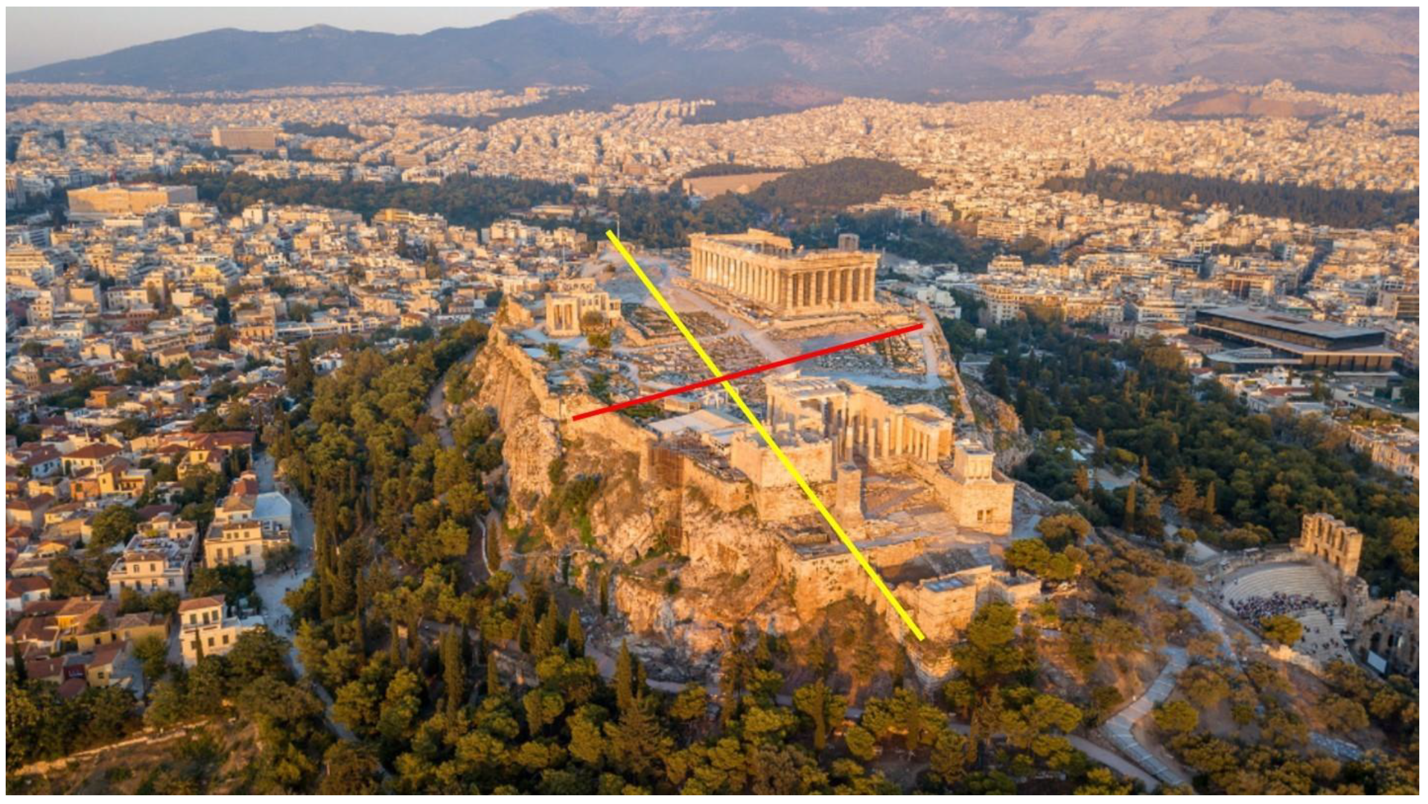
The Acropolis hill rises 156 m above sea level, while the perimeter ground rises between 60 and 70 m. When viewed from above, the ridge of the hill resembles the shape of an ellipse. The largest axis of this ellipse, which runs east-west, is estimated to be about 250 m long, while the smallest axis, which runs across the width of the rock, is about 150 m long (
Figure 5).
The lithostratigraphy of the Acropolis area is relatively simple. It is primarily made up of two lithostratigraphic units: the Athens schist and the Acropolis limestone [
39].
The Athens schists are found in the basal zone of the area and at the base of the hillsides (
Figure 6) and date back to the Cretaceous period (Maastrichtian to Eocene (?) in age) with the original sediments being deposited 72 million years ago, in a river delta. According to Marinos et al. [
40] the Athens schist is a flyshoid phase of a delta-type deposit, which means that what we see today was once the talus of a huge river’s delta. This formation has a distinct reddish color and is composed primarily of soft rock. The Athens schist is made up of a variety of low-grade metamorphic and relatively soft rocks. The stratigraphic formation was given its name because it covers a large portion of the city of Athens. The Athens Schist bedrock exhibits exceptional weathering, as well as intense folding, shearing, and extensional faulting, completing the structural “downgrading” of the rock mass.
The upper parts of the Acropolis hill (
Figure 6) are made of limestone of the Cenomanian-Turonian age, about 30 million years older than the underlying Athens schist, that is no more than 40 m thick [
39]. Compressional tectonic forces thrust the Acropolis limestone over the Athens schist, forming a nappe or overthrust sheet. Erosion of the limestone nappe caused the Acropolis to detach, resulting in the current feature. There are springs and karstic caves where the Athens schist and the limestone meet. The erosion of the same nappe that formed the Acropolis formed many of the hills in the Athens region. These include the Lykabettu, Areopagus, and Museum hills. The marble used to build the Acropolis came from the quarries of Mount Pendeli, a mountain to the northeast of Athens [
39,
41].
The geological composition and structure of the Acropolis Hill were crucial in its preservation. Perhaps it influenced human history as well, as we know that despite the major earthquakes that struck Attica during the historical years, this monument remained unaffected. Aside from the Parthenon, earlier and later buildings and constructions dating back over 2500 years have been preserved on the hill.
2.4. The Geosites of the Sacred Rock of Acropolis
The Sacred Rock of the Acropolis is an important urban geosite of archaeological, historical, ecological and geological interest [
42], which has been designated a UNESCO World Heritage Site, since 1987. Acropolis and its monuments are global symbols of classical spirit and culture and constitute the largest architectural and artistic complex bequeathed by Greek antiquity to the world. Its monuments were developed by an extraordinary group of architects (such as Ictinus, Callicrates, and Mnisiklis) and sculptors (such as Phidias, Alcamenes, and Agoracritus), who transformed the rocky hill into a unique complex that heralded the emergence of classical Greek thought and art. The Acropolis hill, apart from its great archaeological and cultural value, also has very important geological value due to the numerous geosites it hosts.
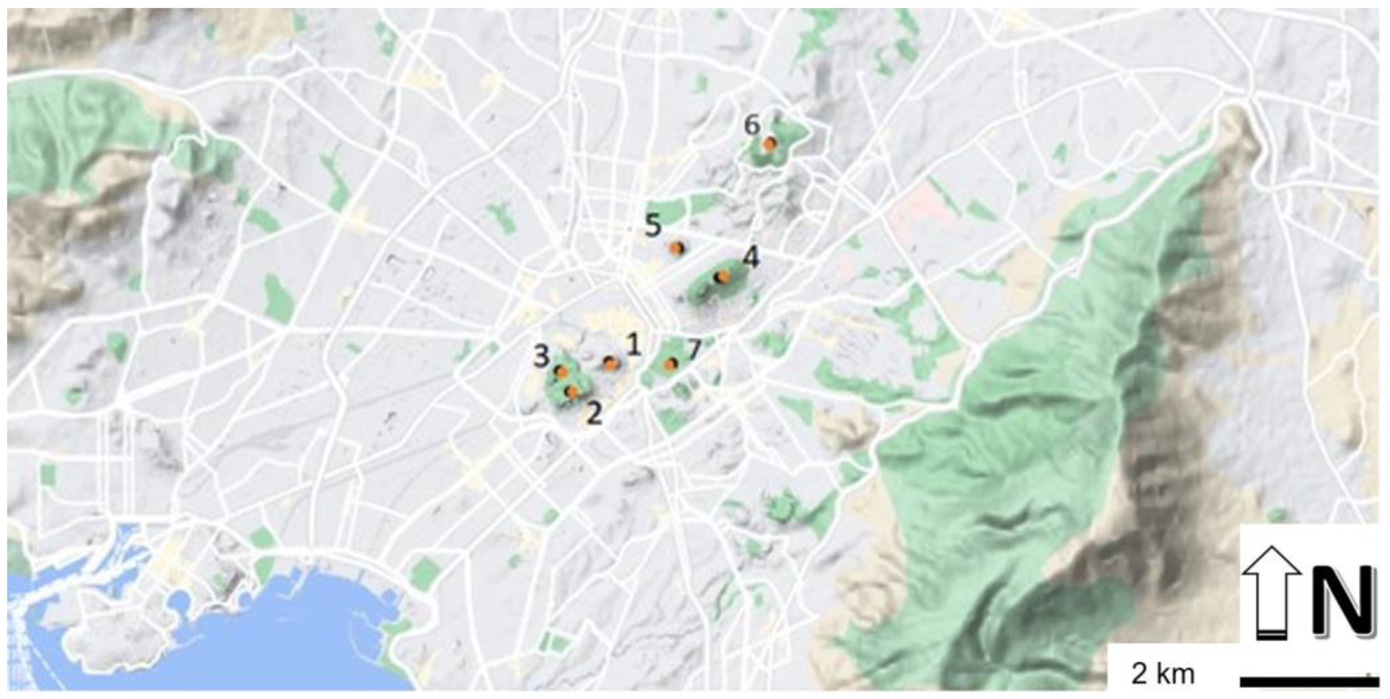
In this study we will focus on the following geotopes (
Figure 7):
2.4.1. GS1: Asclepieion
The Asclepieion of Athens (
Figure 7) was a sanctuary dedicated to the god Asclepius, one of the most important healing deities of Ancient Greece, and his daughter Hygeia. It is located on the south side of the Acropolis, west of the theater of Dionysus, and occupies the space between the ancient Promenade and the Acropolis rock. A spring inside a cave in this location still gushes water today. The action of rainwater causes chemical corrosion on limestone rocks. Water penetrates the soil and forms karst forms, such as hollows and caves, where there is no surface drainage. The limestone rocks on the Acropolis hill’s slopes are intensely karstified, with caves and an aquifer at the contact of the permeable limestone with the underlying Athens schist, which is impenetrable, due to its clay composition. The ancient Greeks considered “clean water” to be essential for the purification and the healing of the sick. People worshiped the god while receiving medical treatments, surgical operations and advice in their sleep. The ritual of ascension was the most distinctive aspect of Asclepius’ therapeutic practice. After being cleansed with spring water and sacrificing on the altar, the patients slept in order to have healing dreams or visions [
43].
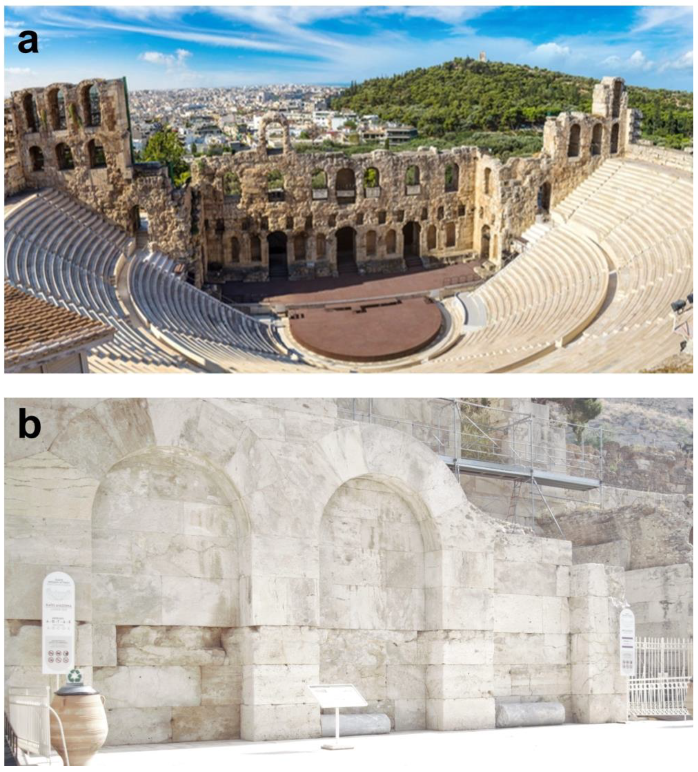
2.4.2. GS2: Theater of Dionysus
The Theater of Dionysus (
Figure 7 and
Figure 8a,b) was a monumental stone theater, built in the decade of 330 or 320 BC. Its cavity had a capacity of between 17,000 and 19,000 seats. Due to its location and construction materials, it is an important geosite. By the end of the 6th century, a theater with wooden seats had already been built. Aktitis Lithos (Stone) eventually took their place. The coast of Piraeus, now known as Themistocles Coast, was famous for its quarries until a few decades ago and for the extraction of a white rock known as Aktitis Lithos (
Figure 8c), which means stone from the coast. This is a marly limestone, a rock which was used to build many monuments in Attica [
44]. The first row of seats, 67 in total, were made of Pendeli marble and were intended for prominent city people [
45]. To emphasize the connection between the events and worship of Dionysus, an elevated and richly decorated marble throne of the priest Dionysus was placed in the center [
46]. The beautiful orchestra floor, which was intended for the “Chorus,” was made of Hymettus marble. The parapet around the stage was also built during the Roman era to safely fill the orchestra with water when boat races were held in the space [
47]. The theater’s location on the south side of the Acropolis meets the requirements of bioclimatic construction. As the theater was open, and the performances took place in early spring, the viewing conditions were heavily influenced by environmental factors, such as temperature, winds, sunshine, the orientation of the theater, the slope of the ground, and so on. Temperatures were higher on the south side of the hill than on the north during this period, as the Rock of Acropolis blocked the north winds. During the day, much of the orchestra was in the shade, but it gradually illuminated until noon. The clarity of the Athenian atmosphere, on the other hand, did not allow the shadow to significantly obscure the action space [
48]. To remove rainwater, a sewer was carved into the rock or built around the orchestra. Its architectural design and implementation on sloping ground were archetypal in architectural history.
2.4.3. GS3: The Choragic Monument of Thrasyllus
The Choragic Monument of Thrasyllus (
Figure 7 and
Figure 8d) is situated on the southeast side of the Acropolis, above the Theater of Dionysus. According to the epistle, Thrasyllu, an eminent Athenian, built the monument in the year 320/319 BC, during the reign of archon Neaichmos, to house the bronze tripod, his victory trophy, in the dramatic games held in the theater of Dionysus [
49,
50]. The monument is located at the entrance of a karst cave. The hidden parts are made of Piraeus Aktitis Lithos and Acropolis limestone. The exposed ones are made of Pendeli and Hymettus marble, while the architraves and the frieze are made of coarse-grained white marble from the Greek islands. The construction of the monument required the adaptation of the curved surface of the cave mouth to a large rectangular opening which presented many technical challenges [
51]. The way the construction problems were solved demonstrates ancient Greek technology, and knowledge of cutting rocks, particularly marble, but also knowledge of geometry [
52,
53].
2.4.4. GS4: Stoa of Eumenes
The Stoa of Eumenes (
Figure 7 and
Figure 8e) is located on the southern slope of the Acropolis, between the Theater of Dionysu and the Herodeion. It was granted to the city of Athens by the king of Pergamon, Eumenes II (197–159 BC), around 160 BC. Vitruvius (Roman writer, architect, and engineer), referring to the galleries built near theaters in general, mentioned that the Stoa served as a shelter for the spectators in inclement weather or as a storage area for the theater scenery. Its structural elements, such as triglyphs, metopes, cornices, columns, and architraves, were made of Pergamon marble which was shipped to Athens. Pergamon marble is not found in any building of Athens. The Stoa was built along the North Wall, which had been built earlier, during the reign of Lycurgus (330 BC), to hold back the embankments of the Promenade level to the north [
54]. The North Wall was reinforced with buttresses joined by arches and was made of hard limestone with gray Hymettos marble uprights. It is regarded as one of the finest examples of extensive pre-construction in the ancient world. Indeed, its architectural members were numbered and marked with masonic letters, to make assembly easier [
54]. The Stoa was also supported in an unusual way, on the Northern Wall of limestone with marble uprights. The Stoa is considered a great technical project of antiquity, the value of which was not fully appreciated until today [
55].
2.4.5. GS5: Odeon of Herodes Atticus–Herodeion
The Odeon of Herodes Atticus (
Figure 7 and
Figure 9a,b) is located at the western end of the Acropolis’ southern slope. Tiberius Claudius Herodes of Atticus donated the land for its construction in the second century AD. The richness of the construction was impressive. White and black marbles were laid on the floor of the orchestra, while colorful marbles adorned the walls. More than 3000 trees, primarily cedars and cypresses, were required to house the hollow. It had the largest roof of any other ancient theater, and it appears to have burned down during the Heroulian raid in 267 AD. The roof covered an area of 3 acres and weighed between 750 and 800 tons. Adding the estimated weight of 180 tons of tiles, the total weight must have been 1000 tons. It was conical and built in one piece, with no intermediate posts, and had a span of 50 m. It was an admirable achievement at the time, and methods used for the construction of bridges were most likely used [
56]. Furthermore, it was initially constructed in the Stoa of Eumenes, which had been converted into a construction site, where the construction’s strength tests were carried out. Later on, with special scaffolding a height of 30 m was built, where the final installation took place. Until the “Hilton” hotel was built, the Odeon was the tallest building in the country. According to Korres [
56], it is a construction marvel comparable to Trajan’s bridge (105 AD), the work of the famous Trajan of Damascus. Its acoustics were suitable for musical performances when there was a ceiling, as opposed to its current outdoor form, where its acoustics are primarily suitable for speech reproduction, such as in the large outdoor ancient theaters used for ancient drama performances [
57].
2.4.6. GS6: Caves
The landscape on the north slope of the Acropolis is steep, wild, and imposing, with karst caves and springs (
Figure 7). It is the site of ancient myths and the worship of the earthy powers of vegetation and fertility [
58]. There are temples of Zeus, Panas, and Apollo Hypoakraios. The Sanctuary of Aglauros (
Figure 8f) is located on the eastern side of the Acropolis and is the city’s largest cave (22 m east-west, mouth 14 m). According to Herodotu, the Persians invaded the Acropolis from here in 480 B.C. Aglauros, the daughter of the mythical king Kekrops, jumped from the Acropolis to save Athens from an extended siege. It was to her shrine that Athenian ephebes, once they had reached the age of 18, brought their military gear, swearing to protect the “sacred and holy” to the death, following the example of the Nymph.
2.4.7. GS7: Klepsydra
Klepsydra (
Figure 7 and
Figure 8g) is the oldest water source on the Acropolis, dating back to before the city of Athens. It is situated on the northwest side of the rock, at the crossroads of the ancient Panathenaia and Promenade streets. The hidden spring was discovered by Neolithic people, who dug 22 wells 3–5 m deep to draw its water. The Athenians discovered water at the bottom of a deep fissure in the Late Bronze Age and built a stone and a wooden staircase to reach it [
59]. It is thought to have formed as a result of an earthquake that caused a 35 m fault to cut through the rock formations on the north-east side of the Acropolis and reach the underlying red shale. This fault contributed to the formation of a cave and a karst spring within it. The spring was dedicated to the worship of Empedus, the water nymph. The Athenians named it “Klepsydra,” which means “water thief,” because its water rose and overflowed when the annual winds, the meltemia, blew, but vanished when they stopped [
60]. This water supply alternation is typical of karst springs, where rainwater infiltrates through cracks in the limestone rocks. Today, the spring’s ruins can be found deep underground, where a 69-step staircase leads to a 10 m deep marble-mouthed well. The ancient spring’s water can be found at the bottom. During rainy seasons, there is so much water that it reaches the Ancient Agora.
2.4.8. GS8: Mycenaean Fountain
The Mycenaean fountain (
Figure 7 and
Figure 8h) was built in the second half of the 13th century AD. It was discovered alongside the Mycenaean wall during the 1937 excavations [
61]. It only lasted 30 years before being destroyed by an earthquake rendering its deepest part useless. Then a large part of the rock detached resulting in the formation of a fault. Its depth is 40 m while its width is 1 to 1.5 m. It was accessible via an invisible ladder, constructed with timber ties and built-in sections. Despite its destruction, it remained a secret passage throughout ancient times. The scale was divided into eight sections. The two upper ones had wooden steps attached to both sides of the rock that led to the northern slope’s cavernous exit. The remaining sections were made of stone slabs, with a well carved in the background, 8 m deep and 2 m in diameter on the upper surface and 4 m on the bottom. The water was pumped with containers, while there was a cavity to collect sediments [
58]. According to Pausanias’ description, the scale is related to the festival of the “Arrifores”, and it is believed that the Arrifores, who were four aristocratic girls aged seven to eleven, descended from here one night in early summer, bringing the “Arrita”, the unspoken things, to the Sanctuary of Aphrodite [
58].
2.5. Quantitative Assessment
Although there are numerous methods for quantitatively assessing geodiversity sites and elements, few of them were designed for urban areas [
62], and urban geodiversity inventories are still uncommon [
63].
In this study, the Suzuki and Takagi [
64] method is used to evaluate geosites in urban environments, modified by Vegas [
65], who evaluated the geosites of the Spanish city of Segovia.
This method consists of six main axes (fields): educational value (Ved), scientific value (Vsc), tourism value (Vtr), safety and accessibility assessment (Vsa), conservation-sustainability status (Vcs) and tourist information material (Vti).
Suzuki and Takagi [
64] set three sub-criteria for each axis, while Vegas [
65] set one extra sub-criterion for each axis, so that the method now has a total of 24 sub-criteria, four for each main axis. Each sub-criterion is scored from 1 to 4, with 1 indicating no score, 2 indicating low, 3 indicating medium, and 4 indicating high.
In the present study, it was considered necessary to redefine certain criteria due to the specificity of some geotopes of the Acropolis rock, which is located at a central point of the city of Athens. Specifically, in the third axis Vtr, in the last sub-criterion concerning the proximity to tourist information points, there was the following change in the scoring steps: score 1 corresponded to a time interval of more than half an hour; score 2 corresponded to a time interval of less than 30 min and more than 15 min; score 3 corresponded to a time interval of less than 15 min and more than 5 min; and finally, score 4 corresponded to a time interval of less than 5 min.
Regarding the fourth axis, Vsa, the last sub-criterion which concerns the accessibility of geosites by people with physical or mental disabilities, was limited only to accessibility by people with mobility problems, including people who have limitations (temporary or permanent) who require accessibility to the environment: the elderly, children, pregnant women, families with pushchairs, people in plaster casts, etc. For this reason, there were the following changes in the scoring steps: score 1 indicated the non-accessibility of the geosite to people with mobility problems, score 2 indicated the accessibility of people with mobility problems but with the help of caregivers, score 3 indicated the accessibility of people with mobility problems but not throughout the entire geosite, and finally, score 4 indicated the accessibility of people with mobility problems throughout the entire geosite.
To make reading and interpreting the results easier, the six axes were grouped into pairs to represent a broader concept. The first axis of educational value, for example, in conjunction with the fourth axis of assessment for safety and accessibility, could indicate educational utility. This value encompassed all age groups, as well as all the characteristics that govern each visitor group. Similarly, the second axis of scientific value, in conjunction with the fifth axis, the assessment of conservation-sustainability status, could encompass all the elements that promote the enhancement of geological heritage. Finally, the third axis, which refers to tourism value, in conjunction with the sixth axis, which refers to the availability of information material on the area’s environment and geology, could indicate the possibility of promoting geotourism.
3. Results
Table 7 shows the six axes with the four sub-criteria and their respective scores.
Table 8 shows the mean values for each axis, obtained by summing the corresponding sub-criteria for each axis, dividing by 4.
At first glance, according to the results presented in the tables above, the Odeon of Herodes Atticus (Herodeion) exhibited the highest scores in each axis, except the last one, which concerns environmental information for geotouristic purposes. It was the most widely recognised geotope, with significant scientific and tourist value. Indeed, it presents interdisciplinarity as it combines architecture with physics (acoustic) and geology (building stones). It is relatively well-preserved, and it is also valuable for environmental education. However, it has limited geological information, which is required for geotourism exploitation.
On the other hand, the Mycenaean Fountain had the lowest scores on each axis, with safety and accessibility being extremely low, and environmental information for geotourism almost non-existent. However, the average score on the first and second axes for environmental education and scientific value was 2.75, indicating that it is interesting in terms of geological heritage.
Regarding the first axis (Value for environmental education—Ved) scores, all geotopes had high scores, ranging from 2.75 to 3.5, with the Mycenaean fountain having the lowest, indicating high value for Environmental Education. The Asclepeion, the caves and the Klepsydra are ideal geotopes for informing and educating the public about the phenomenon of karstification. The Theatre of Dionysus, the Monument of Thrassylus and the Stoa of Eumenes provide information about marly limestone (Aktitis Lithos), the marble of Pendeli and the marble of Hymettus, as well as their use as building materials. Moreover, the bioclimatic construction of the Dionysu Theatre can provide additional information on the climatic conditions prevailing at the time of its operation. The Klepsydra, apart from the phenomena of karstification, is directly linked to natural hazards, since its origin is due to seismic activity and the creation of a fault line. Consequently, because these geotopes are part of the world-famous Acropolis rock, their educational use is especially beneficial to students around the world. However, geo-environmental education has not taken advantage of this very important urban geotops. Students are more concerned with the cultural and historical significance of the Acropolis rock and its monuments than with its geological and scientific significance. They are perplexed by the close relationship between geological and cultural heritage [
66].
As far as the second axis is concerned, which is about the scientific value, the studied geotopes scored highly, ranging from 2.75 to 3.5. Indeed, these geotopes are studied from an interdisciplinary perspective, since they serve as reference points in different areas of study and research (petrology, paleoclimatology, architecture, mechanics, physics, hydrology, natural hazards).
The scores on the third axis, which reflects the geotopes’ tourist value, remained high, ranging from 2.5 to 3.75, indicating that the studied geotopes have great potential for tourist development and appeal to a diverse range of tourists.
In the fourth axis, which concerns safety and accessibility, four of the eight geotopes had very low accessibility, less than 2 (caves, Mycenaean fountain, Klepsydra, Thrasyllus monument), while the others appeared to be more accessible and safer for a tour. The Herodeion demonstrated the highest level of safety and accessibility.
In the fifth axis, which concerns conservation and sustainability, scores ranging from 2.25 to 3 were observed. In its long history, the geological and cultural heritage of the Acropolis rock have been severely damaged. As an example, in June 1641, many buildings in Athens were severely damaged by stones falling from the Acropolis. In November 1805, a strong earthquake caused significant damage to the Parthenon. However, if there is one thing that has been of great concern to scientists and engineers, it is the secret of the Acropolis rock’s flawless seismic behaviour in a 25-century history of earthquake tremors. In general, the Acropolis and its monuments are genius structures in terms of their seismic risk behaviour. However, these unique monuments have suffered man-made and natural disasters over the course of history from various causes (wars, earthquakes, etc.), requiring a special study by experts to restore them, which is a particularly demanding and difficult task. Since the foundation of the new Greek state in 1830, restoration efforts have been made and projects have been launched to repair any damage caused by natural disasters. However, it is always imperative that man-made interventions protect and enhance these geological sites so that they are preserved as unchanged as possible over time, as they are monuments of historical and geological value of global interest.
Finally, the sixth axis had rather low scores, ranging from 1.5 to 2.25. While the historical and cultural information material is very rich, the same is not true for the geoenvironmental information. Therefore, the visitor’s knowledge of the geological characteristics of the area is minimal, which means that geological information to promote geotourism is almost non-existent. Furthermore, there is no information leaflet on the geoheritage of the Acropolis Rock as one of the most intensively developed and visited areas, nor are there any signs or QR codes. There is, therefore, a lack of awareness of the fact that the Acropolis Rock has high geological value, and its promotion is expected to increase geotourism and public awareness of geoenvironmental and geoconservation issues.
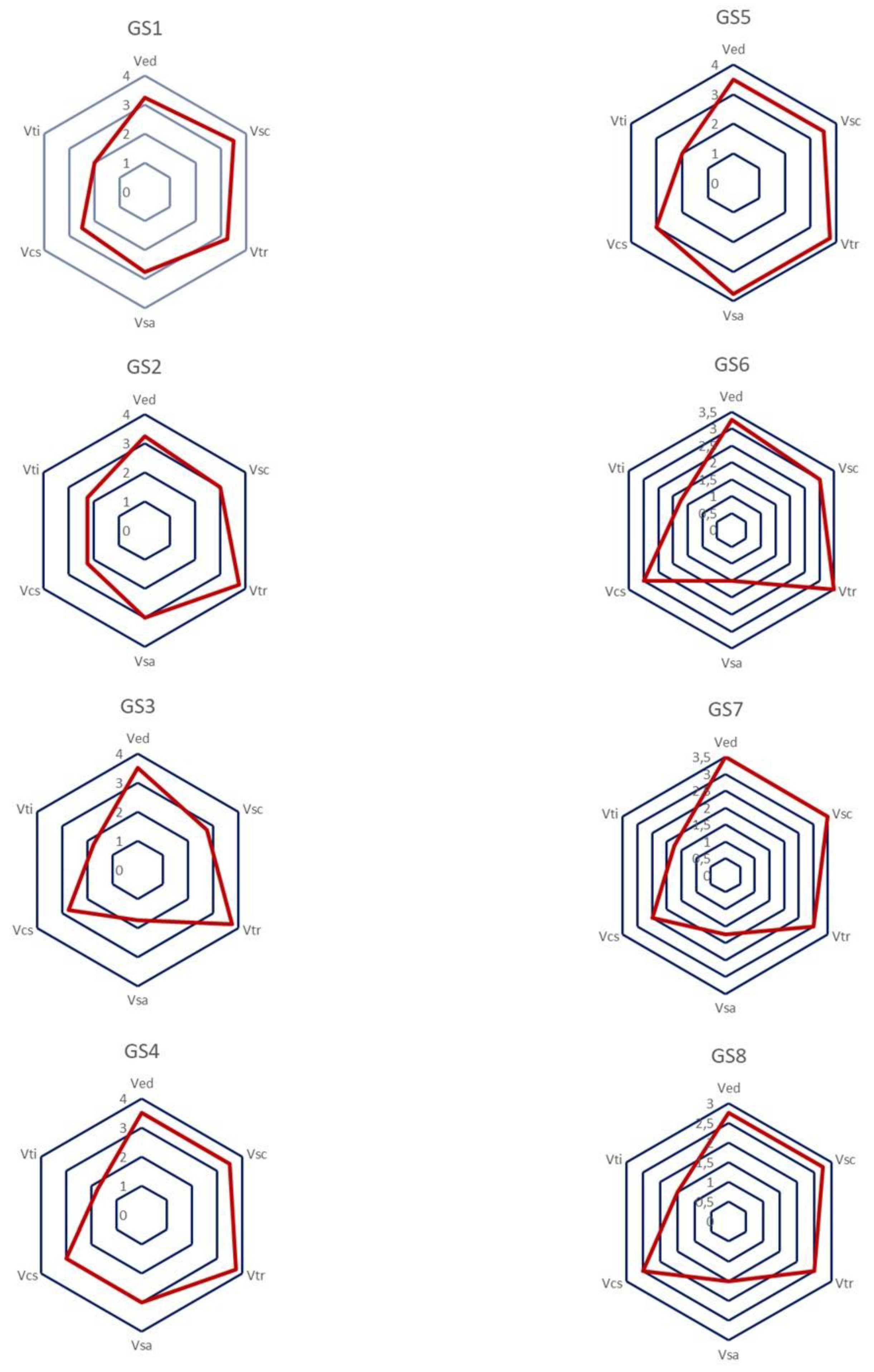
The scores for each axis for each geotope were plotted with radar type diagrams, as shown in
Figure 10.
According to the radar charts, all the geotopes studied had a high educational value (Ved) (score > 3), except for the Mycenaean Fountain (GS6), which was close to score 3. However, in addition to educational value, the majority of the geotopes had relatively high accessibility scores (Vsa). This is critical, because educational activities for all age groups could be developed without difficulty.
All the geotopes had a high scientific value (Vsc) (values/scores > 3) (except the Thrasyllus Monument-GS3 and the Mycenaean Fountain-GS6, which were close to score 3), while also having satisfactory conservation status values (Vcs).
As a result of the above combinations, there is the possibility of promoting and highlighting the geological heritage reflected in the study areas.
Finally, all the study sites had quite high scores in terms of the tourism value (Vtr) they project (six of the eight study sites had values greater than 3). However, they did not quite have satisfactory scores in relation to the information material (Vti) provided (all study sites had scores < 3). This highlights an issue that must be addressed immediately in terms of informing and promoting the values held by these sites. This will only highlight their geotourism value.
4. Discussion
Athens is a city with high geotourism potential due to the large concentration of unique, easily accessible geotourist sites in the area, well-developed tourist infrastructure and good information support. The geotourist sites of Athens are carriers of historical and cultural information, elements of the urban ecosystem.
The Acropolis of Athens, a monument with worldwide fame and recognition, is a combination of natural and cultural heritage. Its natural heritage cannot be separated from the building heritage, according to the UNESCO Convention for the Protection of the World Cultural and Natural Heritage, adopted by the General Conference of UNESCO on 16 November 1972. The study of building and decorative stones used throughout the history of Acropolis hill is, therefore, one of the most important approaches to combining geology and cultural heritage in an urban environment. It is worth noting that natural stones were used as building and/or decorative materials in historical cities. Many experts have focused on building materials that reflect geology at the local/regional level. Morra et al. [
67], for example, investigated volcanic materials used in various construction projects in Naples (Italy) and discovered links between geological and architectural heritage. D’Atri et al. [
68] and Borghi et al. [
69] attempted something similar for Milan and Turin, respectively, in Italy. No doubt, this reflects an aspect of urban geoheritage that cannot be ignored. Del Lama et al. [
18], in their publication on urban geotourism opportunities in the old centre of Sao Paulo (Brazil), highlighted the value of building stones in addition to the importance of local geomorphological features for the development of the city.
The importance of the cultural history of the Acropolis, which is linked to its archaeological and mythological history, is considered indisputable. Its geological history is evident in the field and one can easily perceive how the geological features have contributed to the preservation of the monument over the centuries. However, geo-environmental education has not utilized this very important urban site. Cheila [
66], in her study, revealed that students perceive, to a high degree, the cultural and historical value of the Acropolis rock and its monuments, in contrast to its geological and scientific value. They struggle to understand the close interaction between geological and cultural heritage. The case of the Acropolis of Athens is an excellent opportunity for the implementation of geo-environmental education programmes that will help students to understand the close relationship between the two types of heritage [
66]. Unfortunately, students lack the fundamental understanding of geosciences, which is important for the daily life of citizens [
70]. Therefore, it is vital to include geoeducation in school curricula, which will take place in the field under the supervision of qualified personnel, using a multidisciplinary, holistic approach, with the goal of producing environmentally responsible citizens with well-developed geoethical values [
66]. Geoeducation is called on to help students recognize the need for management of the natural environment, with a sense of responsibility and participation. Furthermore, geoeducation makes it clear that the preservation of geodiversity is a basic condition for the preservation of biodiversity [
71].
Unfortunately, in the Greek educational system, this knowledge is provided in primary school through a series of course-thematic units of a few teaching hours, in the context of Geography course, taught by unskilled geology teaching staff [
72], while in Lower High School Education, through the subject of Geology-Geography, where there is a lack of topics on geoheritage [
73]. Moreover, the number of environmental groups in Greek schools that choose to develop an environmental program with a geoenvironmental theme is very limited [
74], according to annual data. As a result, student education is characterised as very limited or non-existent, and it is regarded as incomplete to negligible in the fields of geosciences and geoenvironmental sciences [
66].
In contrast to geological heritage, the orientation of curricula in cultural heritage understanding is evident through various disciplines (History, Religion, Literature, Visual Arts) and several cultural programs that are annually and voluntarily prepared in Greek schools. However, no research has been conducted on pupils’ and students’ geological understanding, geoethical awareness, or cultural heritage understanding. The work of Georgousis et al. [
75], who investigated the younger generation’s geocultural consciousness, focused on the geological dimension of the world-famous cultural heritage object, Meteora Geomorphes, in Greece, to establish the younger generation’s understanding of the geological heritage concerning cultural heritage, and is the only exception. According to their results, pupils and students in Greece perceived, to a high degree, the aesthetic value and cultural value of geodiversity, with its historical, archaeological and religious aspects, compared to geological value, which was perceived only to a moderate degree. At a moderate grade, they also perceived the scientific value of geoheritage, but recognised the need for geoeducation.
Geotourism has several considerations as well. The high historical and cultural values of the studied geotopes have enormous geotourism potential, which could be developed by establishing a visitor center and organizing more frequent tours. The geoheritage of the Acropolis rock could be promoted through geotours that offer a special tourist (and educational) package and provide an overview of the Acropolis’ geodiversity, and could be included in Athens’ tourism strategy and promotion. Similar cases of geotours exist in London [
76], São Paulo [
18] and Rome [
77].
Except for the caves, the geosites studied in this work are open to the public. This is critical because visitors can see the rocks and unique geological features of each monument. They can tell the difference between the various rocks from which they are formed, such as Pendeli marble, Aktitis Lithos, and so on. However, for the description, understanding, and importance of the geological value, a specialised person who knows geology is required to transmit this knowledge.
Some key considerations and future projects that should be adopted by local governments and incorporated into city planning processes, are proposed. This initiative could be developed into a geodiversity action plan for the city of Athens, which would be the first of its kind for a city in Greece. Such a plan is urgently required to avoid the degradation and destruction of the Acropolis rock’s geological heritage.
The assessment of these geosites should serve as a catalyst for further research into the following: the recording of fauna and flora, in order to highlight biodiversity (biodiversity is listed as an additional value in several inventories, and its detailed assessment should be done separately by appropriate experts); cultural heritage relevance, inviting experts to record the possible associations of each site in this regard; safety and conservation by landscape engineers and architects, who can survey sites to find creative ways to ensure safety while preserving heritage and integrating it into the urban fabric sustainably.
Furthermore, our findings demonstrated the utility of applying the quantitative assessment method developed by Suzuki and Takagi [
64] to urban geosites. This is not the first time this method has been used to assess the potential for geotourism and geoeducation in an urban setting. However, it should be emphasised that in order for the assessment results to be representative of the studied geosites and the target audience group (audience specificities), the peculiarities that may be concealed in each geotope must be taken into account. Modification of the sub-criteria (addition or removal of sub-cases) is required in this case.
5. Conclusions
The Acropolis Rock is one of the most admirable and recognisable monuments in the world, known worldwide for its archaeological, historical, and tourist value. At the same time, it is a remarkable monument of geological heritage, which is, however, unknown to the public. The study of building and decorative stones used throughout the history of the Acropolis hill is one of the most important approaches to combining geology and cultural heritage in an urban environment.
This study described and evaluated eight geosites on the Acropolis rock.
From the assessment data, it was concluded that the studied geosites presented high scientific and touristic value, as well as high value for environmental education. Through the discussion, the immediate need for the integration of geoeducation into the curricula of schools became apparent, so that, apart from the archaeological and cultural value of this world-famous monument, its connection with geological heritage can be made known. At the same time, however, in most geosites there is difficulty in accessibility for different reasons in each one, as they are located in different parts of the rock of the Acropolis, which presents special geological and topographical interest.
The possibility of exploiting these geosites in terms of geotourism is very high and important for strengthening the economy of the place, but mainly for raising the awareness of visitors on matters of the environment, geological heritage, and geoconservation. The sustainability and utilisation of geosites, based on the principles of sustainable development, provide multiple benefits for society and future generations.


