1. Introduction
UNESCO Global Geoparks (UGGps) “are single, unified geographical areas where sites and landscapes of international geological significance are managed with a holistic concept of protection, education, and sustainable development. Their bottom-up approach of combining conservation with sustainable development, while involving local communities is becoming increasingly popular” [
1,
2]. The concept of geoparks began to evolve in Europe 26 years ago [
1,
3,
4]. The main goal of a geopark is the territorial development of an area with significant geoheritage and natural and cultural wealth as well, in order to promote the sustainable development of local communities through the promotion of geotourism and education [
3,
4,
5]. Today, there are 169 UNESCO Global Geoparks located in 44 countries around the world [
2]. In Greece to date, six areas have been designated as UNESCO Global Geoparks: Lesvos (2000), Psiloritis Natural Park (2001), Chelmos-Vouraikos (2009), Vikos–Aoos (2010), Sitia (2015) and Grevena–Kozani (2021). According to UNESCO [
2], UGGps have multidimensional aims which include primarily the protection and conservation of their territorial geoheritage and additionally the cultural and environmentally sustainable development of their territories [
6]. Geoscience education offered at all levels is another goal for UGGps promoting awareness about the history of the earth and sustainable development [
7]. UNESCO Global Geoparks are basically about humans and about exploring and celebrating the connection between our communities and the Earth [
2]. The Earth shapes human identities: it has shaped people’s agriculture practices, the building materials and methods that have been used for constructing their accommodation, and even their mythology, folklore as well as folk traditions. In addition, it is the basement for all earth systems and services (natural values, biodiversity, resources, etc.) [
8,
9]. UNESCO Global Geoparks, therefore, engage in a range of activities to celebrate these connections. The Operational Guidelines of the UGGps define 10 focus areas in which the geoparks should develop activities [
9] and for which they are evaluated every four years [
10]. These areas refer to the natural resources of their territories, and their sustainable use; to geohazards and climate change; to education of local inhabitants and visitors; to natural and cultural heritage; to science and research; to local culture and the celebration of local heritage; to the empowerment of women and equality; to indigenous people and knowledge, if they exist; to the sustainable development through geotourism; and to geoconservation and safeguarding the geological value of their territory.
Over the past three decades, several methodologies for the quantitative and qualitative assessment of Earth’s heritage have been developed [
11,
12,
13,
14,
15,
16,
17,
18,
19,
20,
21,
22,
23,
24,
25,
26,
27,
28,
29,
30,
31] to serve geoconservation and geotourism needs. They aim in minimizing subjectivity in the procedure of organizing the results into an understandable and well recognizable ranking system. Unfortunately, subjectivity cannot be avoided when scoring scientific importance, the need for protection or the potential use of geosites, however, in most cases specific criteria with certain scoring systems are introduced to cope with this problem. When it comes to the preparation of management plans that should be both socially accepted and useful [
18,
19], the establishment of objective criteria is required [
2,
5]. The first methods were developed for the assessment of geomorphosites and landscape features in general [
11,
13,
16,
17,
18,
23,
24,
25,
27,
29], focusing mainly on their aesthetic and scientific values, while others on karst geomorphosites [
22,
26], or on volcanic geomorphosites [
30] as well. Several other methods also induced the assessment of educational [
21] and geotouristic values presenting in that way a more complete approach on the overall geosite value [
12,
15,
20,
31] Among existing methodologies, quite a few were developed primarily for the need of UGGps to achieve progress on the 10 focus areas [
14,
19,
28]. The assessment of the geosites of a geopark not only has a scientific purpose but also aims at the management and conservation of its geological heritage at a certain territorial and legislative context and under the operational framework induced by UNESCO. Geodiversity needs to be considered in a wider view, combining sustainable development with the conservation of geoheritage [
19]. Therefore, such assessment becomes a useful tool for site managers, because it highlights and quantifies the priorities needed for the proper management and protection of the geopark. It can also highlight priorities for sustainable tourism development (geotourism and educational tourism) as well as for the conservation of geosites.
The main objectives of this study are, first, the evaluation of the 40 geosites of Chelmos-Vouraikos UGGp in order to highlight their touristic and educational value as well as the need for their protection, and secondly, the evaluation of the selected methodology, through which its advantages, as well as the respective weaknesses that might need improvement, will be highlighted.
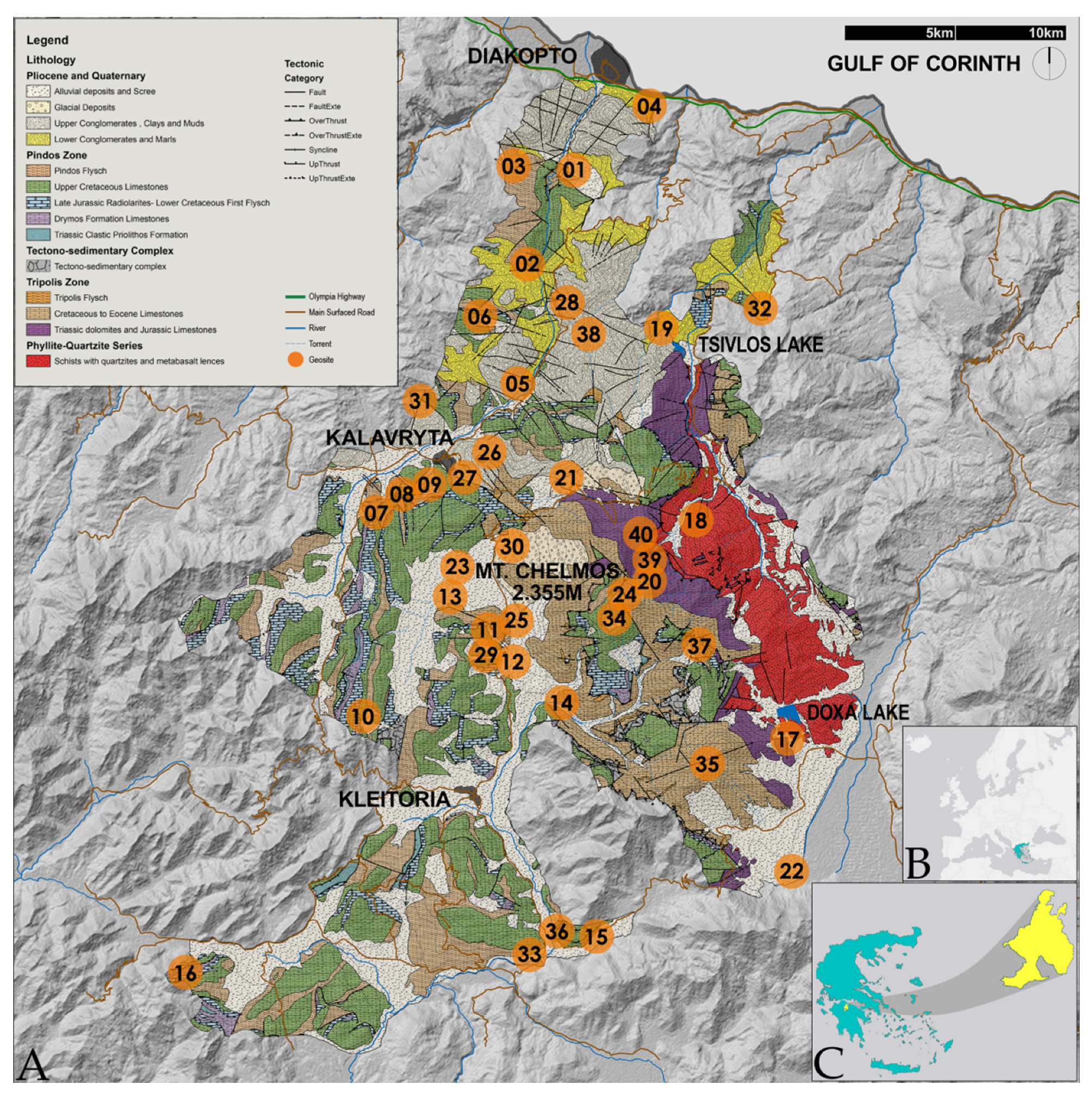
2. Geopark Outline
Chelmos-Vouraikos UGGp is located in North Peloponnese (Greece). It occupies an area of 647 km
2 with a total population of approximately 27,000. The area exhibits unique geoheritage, wonderfully combined with rich bioheritage and exceptional cultural and historical elements. To date, 40 geosites have been established in the geopark (
Table 1,
Figure 1). They include unique geological formations (folds, faults, rocks and lithological formations, etc.), karstic geomorphs (caves, poljes, karstic springs), rich geomorphosites (gorges, high peaks, alpine lakes etc) and fossil sites.
At least 485 million years (lower Palaeozoic) of geological history are “unfolded” in the area of Chelmos-Vouraikos UGGp. The alpine basement consists of three geotectonic zones, namely Tripolis Zone, Pindos Zone and the metamorphic Phyllites–Quartzites Suite which is the oldest. Post-alpine formations, whose deposition is related to the Corinth rift, overlap the alpine basement (
Figure 1).
Tripolis Zone consists of Mesozoic neritic limestones and dolomites [
32], with a maximum visible thickness of approximately 3500 m [
33]. The formations of this unit can be found at the east-southeast part of the geopark, on Chelmos Mt, along Krathis river and at the northern part of Vouraikos gorge. The basement of this zone is the Upper Palaeozoic to Lower Triassic volcano-sedimentary Tyros beds. They consist of a complex of sedimentary and volcanic rocks, which is characterized by a very low grade of metamorphosis. Carbonate sediment deposition in shallow marine environments began during the Early Mesozoic and lasted until the Late Eocene. Flysch formation followed until the end of the Oligocene. The Tripolis Zone underlies sediments of the Pindos zone and post alpine sediments. The whole sequence was overthrusted above the Phyllites–Quartzites Suite.
Pindos Zone develops mainly to the west and south part of the geopark. It consists of a Mesozoic sequence of carbonate and silicate sediments deposited in a deep-sea environment. Their thickness does not exceed 1050 m [
33]. At the base of the sequence, the middle Triassic clastic Priolithos Fm is found. Drymos Fm limestones, with an Upper Triassic–Lower Jurassic age, lie on top of it. The Upper Jurassic to Lower Cretaceous Radiolarites Fm (
sensu lato) which overlies the Drymos Fm consists of alternations of pelites, cherts (mainly radiolarites) and limestones with Calpionellids. During the Albian to Cenomanian, the First Flysch Fm was deposited. Upper Cretaceous thin-bedded limestones follow. These limestones during the Late Maastrichtian–Eocene evolved gradually into flysch [
34].
The rocks of the Phyllites-quartzites Suite appear at the tectonic window of Chelmos Mt, along the Krathis River and in the Feneos plateau (polje) as well. Τhe rocks of this Suite have been formed under high pressure/low temperature metamorphic conditions [
35,
36]. They consist of phyllites and quartzites that originated from a detrital sequence, whereas in some places mafic rocks are intercalated. Zircon dating methods provided an Early Palaeozoic age for these rocks [
37].
Post-alpine sediments (Late Neogene–Quaternary) were deposited across a WNW-ESE direction lying parallel to the Corinth Rift system which is responsible for their formation. The total thickness of these sediments is approximately 2.8 km [
38]. At the north of the study area, five major north-dipping normal faults can be found (from south and older to north and younger): Kalavryta, Kerpini–Tsivlos, Doumena, Pirgaki–Mamoussia and Helike [
38]. These faults have confined a series of approximately WNW-ESE north dipping rotated fault blocks associated with the regional N-S extension of the Rift [
39]. Accordingly, these fault blocks formed the half-grabens where Pliocene and Quaternary sediments were deposited unconformably on the substrate [
40].
According to Ford et al. [
41] and Pope et al. [
42], at the top of Mount Chelmos, as well as on the surrounding edges, glaciers developed during the Middle–Late Pleistocene. Glaciofluvial brecciated deposits can be found around the mountain’s high peaks along with other glacial geomorphological evidence (moraines, cirques, alpine lakes).
The area of the geopark is also valued and protected for its biodiversity and has been classified as a “National Park”, managed by the Chelmos-Vouraikos Management Body and taking into consideration (a) the “IUCN Guidelines for Applying Protected Area Management Categories” and (b) the legal framework for conservation management of the Chelmos -Vouraikos National Park pertaining to four Natura 2000 sites (IUCN Management Category II) [
43]. It is also rendered as a biodiversity hotspot of the Greek flora and is included in the endemism hotspot region of the mountain ranges of Northern Peloponnesus [
44,
45,
46]. The natural vegetation of the Chelmos-Vouraikos UNESCO Global Geopark is the result of the interaction of various parameters and mainly of its various orographic configuration, petrological–geological composition, bioclimatic conditions and human activities that have shaped the landscape since historical times. This results in the contemporary, complex land-use fabric which includes semi-natural and natural ecosystems subject to traditional human practices, as well as ecological, historical and culturally important landscapes [
10].
The people living in the area are mainly farmers and stockbreeders, who take advantage of the rich resources of their land and produce local products famous for their quality and uniqueness, such as dairy products, honey and legumes. In addition, an important driving force for the local economy is tourism. “Odontotos” rack railway runs across the steep Vouraikos gorge, passing by some of the Geopark’s unique geosites, attracting thousands of tourists and giving them the opportunity to admire the incredible geomorphology of the gorge. A popular ski center is hosted at the unique glacial valleys of Chelmos Mt, while the spectacular Cave of the Lakes serves as an exceptional geomorphosite of touristic value. These are classical examples of the way that the geomorphology of the Geopark area shapes the local geotouristic character and provides the means for sustainable development. A large number of tourists is hosted every year at the numerous accommodation facilities that exist in the area.
The area played an important role during the Greek uprisings and for this reason it has a great history. This is witnessed by the numerous monuments of war atrocity which can be found scattered in the area of the geopark (e.g., Holocaust Monument at Kapi hill). The rich history is communicated to the public through the multiple museums (e.g., Holocaust Museum, Folklore-art Museums of Kleitoria and Feneos, etc.). The area has also great archaeological (e.g., archaeological sites of ancient Lousoi and ancient Kleitoria) and religious interest (e.g., historic monasteries of Mega Spilaio and Agia Lavra). One more aspect of the geopark’s multidimensional value is its intangible heritage, which is wonderfully expressed through popular art especially music and poetry and mostly through the great mythological heritage. The myths and the legends that concern specific parts of the geopark are countless. Characteristic examples are the Feneos sinkholes which are connected to the mythical semi-god Hercules as are also the geosites of Portes-Triklia and Roghi.
The geopark offers a spectrum of promotional tools related to its geoheritage, especially geotrails (seven georoutes) and informative material available at the Information Center of the Management Body. Combined information regarding the geoheritage and its links to biodiversity and culture are presented on the geopark’s informative signage.
4. Results
The analytic results (criteria scores) of the 40 assessed geosites of Chelmos-Vouraikos UGGp are presented in
Table 4. The average score of the scientific criteria ranges from 2.1 to 9.5, while the score of ecological, aesthetic and economic criteria ranges from 1 to 10. Furthermore, the cultural criteria values dο not exceed 5.9. The criteria for potential use start from 3.9 and reach up to 9.5.
Τhe geological report and the criteria analysis for ten typical examples of geosites (geosites 2, 7, 11, 14, 19, 20, 24, 28, 35 and 38) are provided in detail in the following sections. These geosites are presented here in detail as they consist some of the most popular and characteristic geosites of the geopark (geosites 2, 7, 11, 14, 19, 28). Some of them also present great need for protection, such as geosites 7 and 14. In addition, very high scores for some of them indicate that they have not been exploited geotouristically so far (geosites 20, 24, 35), while for other geosites, such as geosite 38, the need for immediate protection is highlighted.
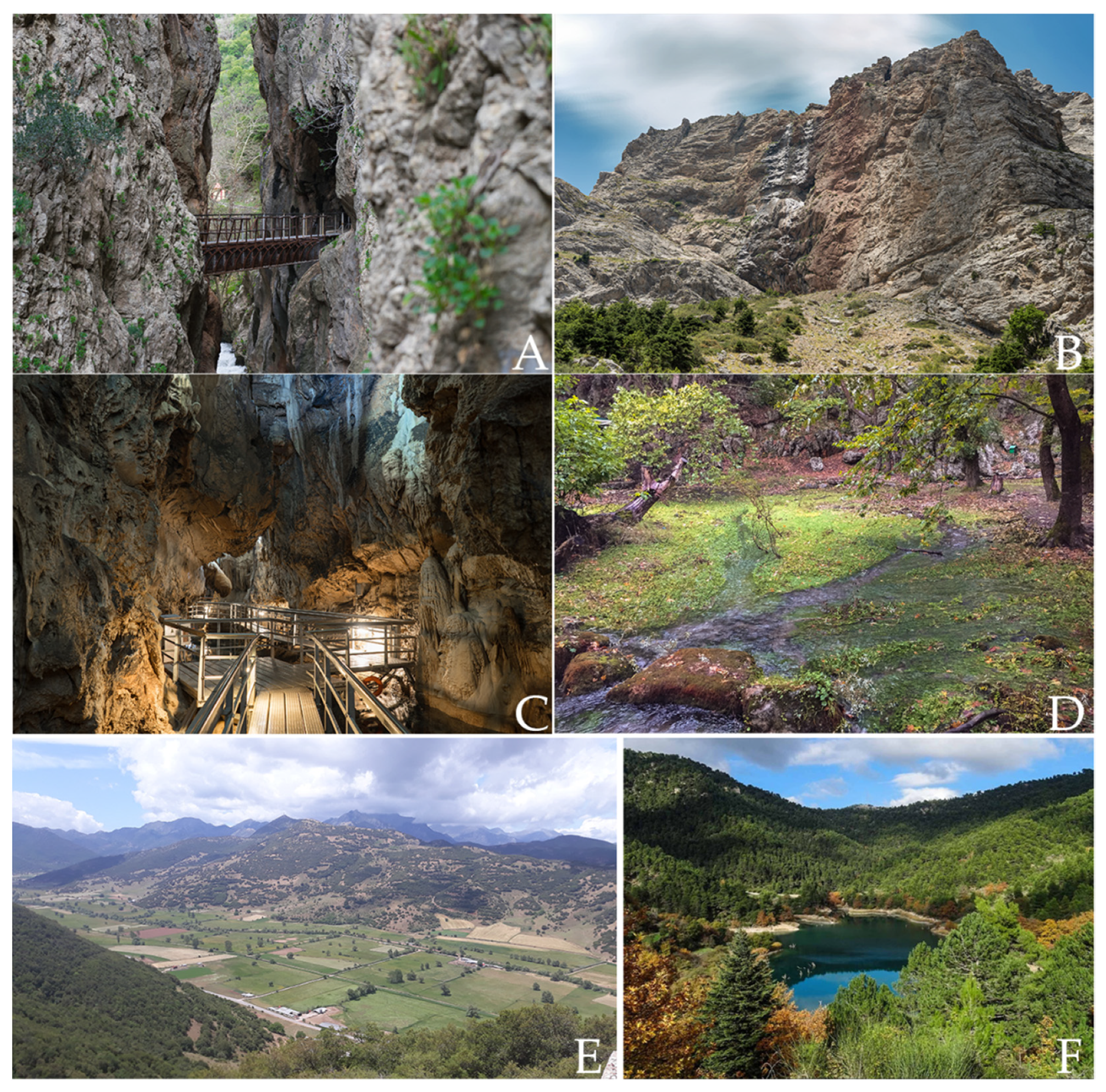
4.1. Portes–Triklia (Geosite 2)
Portes–Triklia (38°6′31.92″ N, 22°9′37.21″ E) is located in the northern part of the geopark in Vouraikos River Gorge. The area consists of Upper Cretaceous bedded limestones of Pindos zone and fluvial-torrential deposits (
Figure 2A). Intense tectonic uplift along normal faults [
54] has shaped the gorge in combination with rapid vertical erosion. As a result, an impressive, very narrow and deep gorge was formed during the Lower–Middle Pleistocene [
54,
55].
This geosite exhibits two types of geological history of the studied area: the deposition of Pindos formation and the intense erosional processes of the river (score of sub-criteria 1.1. and 1.2., 2.5 and 10 respectively). The geological features and the processes related to this geosite are the deposition of the limestones of Pindos zone, the deposition of the fluvial-torrential deposits of Vouraikos river, the high rate of uplift of the wider area combined with the intense vertical erosion of the river (score of sub-criterion 1.3. 7.5). This unique combination of features can be found in no other geosite in the geopark (score of sub-criterion 1.4. 10). The existing status of conservation from human activity and natural processes is considered slightly damaged due to the construction of the historic “Odontotos” rack railway (score of sub-criterion 1.5. 7.5).
The floristic importance of Vouraikos gorge is very high, due to the presence of rare endemic species. The avifauna of the wider area is also remarkable especially because of the high number of species that reproduce there (score of sub-criterion 2.1. 10). The state of actual protection and conservation is very high (score of sub-criterion 2.2. 10) throughout the gorge area.
The European E4 path passes also through this geosite. Its route lies along the Rack railway tracks and is used by thousands of Greeks and foreign hikers every year. The intangible heritage of Vouraikos gorge is invaluable since it is related to Hercules myths. (scores of all sub-criteria of cultural criterion are 2.5 each).
The geosite is not visible from afar mainly due to the dense vegetation but also due to the geomorphology of the area (steep gorge) (score of sub-criterion 4.1. 10) and does not differ from the background (score of sub-criterion 4.2. 7.5).
The historic “Odontotos” rack railway is cross passing this geosite attracting thousands of visitors-Greek and foreigners- each year (e.g., 159,789 visitors during 2018 according to the Hellenic Railways Organization) (score of sub-criterion 5.1. 10). Therefore, it is considered an international attraction (score of sub-criterion 5.2. 10). Vouraikos gorge is located in a NATURA A3 zone area (SCI_GR2320003 and SPA_2320013), (score of sub-criterion 5.3. 1).
No negative effects from human use have been recorded apparently because it is located in a NATURA A3 protection zone (score of sub-criteria 6.1. and 6.2. 10 each). Its physical parameters are characterized by very high fragility (score of 6.3. 10), so changes are not acceptable without the risk of degradation of the geosite (score of sub-criterion 6.5. 1). The site can be reached either from the homonymous railway stations, or by hiking across the E4 path, departing from Diakopto or Zachlorou (score of sub-criterion 6.4. 1).
4.2. Tectonic Graben of Kalavryta (Geosite 7)
The Tectonic Graben of Kalavryta (38°1′59.59″ N, 22°6′30.94″ E) is located at the central part of the study area. Kalavryta basin formed during the Early Pliocene due to the N-S extension of the area, being the oldest half-graben of the Corinth Rift (
Figure 2E). During the first stages of the basin development, lakes were formed. In these lacustrine environments, layers of clays and marls were deposited, with intercalated lignite layers rich in fossil plants [
54]. Alluvial fun sediments fill in the basin upwards [
55].
The Kalavryta basin depicts the post alpine geological history of the study area (score of sub-criterion 1.1. 7.5). It is the oldest basin formed due to the continuous rifting process of the Corinth Gulf (score of sub-criterion 1.2. 5). Both the tectonic mechanism of the basin formation and the deposition of the oldest post-alpine formations above the alpine basement are important geological processes that have taken place (score of sub-criterion 1.3. 7.5). Thus, the tectonic graben of Kalavryta is considered unique (score of sub-criterion 1.4. 10). However, it is strongly deteriorated by human activity, since an entire town has been built on it, and has no protection status (score of sub-criterion 1.5. 2.5).
The ornithological value of the area of Kalavryta is characterized high, along with Vouraikos gorge and Chelmos Mt. (score of sub-criteria 2.1. and 2.2. 5 and 1, respectively).
Kalavryta is one of the most historic settlements in Greece, as it is inextricably linked to both the Greek War of Independence (against Ottoman Empire) of 1821 and the German occupation during World War II. Furthermore, the Folklore and Historic Museum and the Museum of the Kalavryta Holocaust (dedicated to the history of the Massacre of Kalavryta in 1943) are located in the city of Kalavryta. Finally, the local train station is the final stop of the historic “Odontotos” rack railway (score of 3.3. 10, while the other cultural sub-criteria were ranked as 1).
The tectonic graben has at least four viewpoints (score of sub-criterion 4.1.–10), and as a low relief surrounded by high peaks it is easily discernable in the landscape (score of sub-criterion 4.2. 7.5).
According to the Kalavryta Hotels Association and the Ski Center of Kalavryta, the number of visitors usually exceeds 75,000 annually (score of sub-criterion 5.1. 10), and thus is considered an international attraction (score of sub-criterion 5.2. 10) but with no official protection (score of 5.3. 10).
Even though there is very intense human activity in this area (score of sub-criterion 6.1. 10), no negative impact on the geosite has been recorded (score of sub-criterion 6.2. 10), since it has a very high degree of resilience (score of sub-criterion 6.3.–1) in relation to potential degradation (score of sub-criterion 6.4. 10). The place can be reached by car along a well-established road network (score of sub-criterion 6.5. 10).
4.3. Cave of the Lakes (Geosite 11)
The Cave of the Lakes (37°57′34.73″ N, 22°8′24.15″ E) is located close to Kastria village, at an altitude of 827 m. It extends to the Amolinitsa Mt, along a NW-SE trending fault. The cave develops in Cretaceous limestones of the Tripolis and Pindos zones separated by a fault. The cave is characterised by a relatively small width and a great roof height. The total length is 1950 m, and its elevation is 85 m, covering an area of 20,000 m2. Apart from the rich speleothems, its most impressive feature is the existence of 13 successive underground lakes, which are located at different levels. These lakes were created due to slow water flow and water stagnation, resulting in the formation of calcitic walls (gours or rimstones) which continue to grow until today. Thus, two types of geological history are combined in this geosite (score of sub-criterion 1.1. 2.5 and score of sub-criterion 1.2. 7.5) and a variety of geological processes took place for the formation of its limestones (score of sub-criterion 1.3. 7.5).
Excavations that took place in the first part of the cave found rich archaeological and paleoanthropological remains showing that the cave was inhabited since 5650 BC, from the Neolithic to the Late Helladic period. The length of the touristic route in the Cave is 500 m (
Figure 2C).
This geosite is unique in relation to those that have been recognized in the geopark (score of sub-criterion 1.4. 10). The interventions in the cave are considered minimum since all tourist facilities have been built under strict protection measures (score of sub-criterion 1.5. 7.5).
In the non-touristic part of the cave, one of the most important across Europe, a winter colony of bats of the species Miniopterus schreibersi [(18,000 individuals), has been recorded (Life Grecabat project) along with nine more bat species (score of sub-criterion 2.1. 10). It is also located within the protected area (Zone B1-SCI_GR2320009) of the Chelmos-Vouraikos National Park (score of sub-criterion 2.2. 10).
According to the myth [
56,
57,
58], the daughters of the King of Tiryns Proetus, found shelter in a cave on Mount Aroania, north to Nonacris, when they were preoccupied by insanity, for punishment because they insulted the gods [
59] (score of sub-criteria 3.1., 3.2., 3.3., 3.4., 1, 1, 5, 1 respectively).
This geosite is underground, it cannot be seen from anywhere except the small natural entrance point that can be seen from the road (score of sub-criterion 4.1. 10). The surface exposure does not differ from the background (score of sub-criterion 4.2. 10).
The visitors to the geosite exceeded 50,000 in 2018 according to official data (score of sub-criterion 5.1. 7.5). Thus, it is considered as a geosite of international level (score of sub-criterion 5.2. 10). It is also located within a protected area (Zone B1) of the Chelmos-Vouraikos National Park (score of sub-criterion 5.3. 1).
Today, the access to tourists is allowed under strict protection measures (score of sub-criterion 6.1. 2.5). The only negative effect is its oxidation caused by breathing (score of sub-criterion 6.2. 2.5). The degree of resistance of its physical characteristics is thus considered high (score of sub-criteria 6.3., 6.5. 10 and 1, respectively). In addition, it is only 17 km from the town of Kalavryta which facilitates access to it (score of sub-criterion 6.4. 10).
4.4. Aroanios Springs (Geosite 14)
The springs of Aroanios River (a tributary of Ladon River) are located (37°56′1.34″ N, 22°9′57.82″ E) near the village of Planitero, at an altitude of 600 m. The springs are supplied by waters from Chelmos Mt which are discharged underground through the sinkholes in the Loussoi polje area (geosite 23). At the northeastern part of the polje a SE-NW oriented normal fault brings in contact Pindos zone limestones with limestones of Tripolis zone. As a result, the water springs out the Upper Cretaceous limestones all year round from 41 small fault-overflow springs (4 m
2/s of water) [
60] (
Figure 2D) (score of sub-criterion 1.1. 1, score of sub-criterion 1.3. 2.5). It is considered as a place with a very high degree of geoheritage representativeness (score of sub-criterion 1.2. 10). This geosite along with Geosite 15 (Mati tou Ladona) are the only geosites of this kind in the study area (score of sub-criterion 1.4.–7.5). The existing state of conservation of the geosite is characterized as moderately deteriorated, due to lumbering (score of sub-criterion 1.5. 5).
The springs are located within the most extensive floodplain forest of the geopark, dominated by plane trees (
Platanus orientalis), which however has been infected by the “metachromatic ulcer” disease due to anthropogenic impact [
61,
62] (score of sub-criterion 2.1.–5). In fact, the whole forest is not protected (except at the springs) (score of sub-criterion 2.2.–2.5).
Endemic species of fishes inhabit in Aroanios River, (e.g., Salmo magrostigma, Barbus peloponnesius). The area is known for the fish hatchery facilities and traditional watermills. Furthermore, part of the E4 European path crosses this geosite (score of all cultural criteria are 1 except of 3.4. that was scored with 2.5).
The springs are not visible from any other place, due to the dense plane trees (score of sub-criterion 4.1. 7.5). This geosite fully harmonizes with the rest of the beautiful landscape (score of sub-criterion 4.2. 5).
Planitero is a popular destination for tourists all year round but especially during the summer and autumn months (score of sub-criterion 5.1. 7.5). It is considered an attraction of national importance (score of sub-criterion 5.2. 7.5). The geosite is located within the Natura B2 zone “Aroanios Springs” and thus its protection status is considered satisfactory (score of sub-criterion 5.3. 1).
Around the springs there are restaurants (score of sub-criterion 6.1. 7.5). Downstream fish farms and old watermills exist, but they do not have negative impact on the springs (score of sub-criterion 6.2. 7.5). It is considered a geosite of moderate resistance to possible degradation (score of sub-criterion 6.3. 2.5). Thus, changes are not acceptable without damage risk (score of sub-criterion 6.5. 7.5). Its accessibility is considered easy, through a regional road, less than 25 km from Kalavryta town (score of sub-criterion 6.4.–1).
4.5. Tsivlos Lake (Geosite 19)
Tsivlos Lake is located at the northeastern part of Chelmos-Vouraikos UGGp (38°4′37.61″ N, 22°13′58.24″ E). The lake was created in 1913, due to the damming of Krathis river after a large landslide, triggered by the preceding strong rainfalls that destabilized the intensely tectonized rocks of the area, blocked the riverbed [
63] (
Figure 2F).
Tsivlos lake depicts a unique geological history, with its formation from a landslide (score of sub-criterion 1.1. 1, score of sub-criterion 1.3. 7.5). In the geopark there is no other permanent natural lake (score of sub-criterion 1.2. 10, score of sub-criterion 1.4. 10). The geosite is kept intact, although it is used by visitors as a recreation area (score of sub-criterion 1.5. 10).
Due to the young age of the lake, the riparian vegetation is still not well developed. It is surrounded by densely forested landscapes with mixed Mediterranean coniferous trees (Pinus halepensis, Pinus nigra and Abies cephalonica) (score of sub-criterion 2.1. 5). The state of protection and conservation of the lake is considered very high (score of sub-criterion 2.2. 10). Two georoutes have this geosite as a starting point (score of cultural criteria are 1, except of 3.3. 2.5).
This beautiful landscape can be accessed through the local road network (Feneos–Akrata) (score of sub-criterion 4.1. 2.5), with a high differentiation from the background (score of sub-criterion 4.2. 7.5). It receives more than 75,000 visitors each year (score of sub-criterion 5.1. 10) and is thus considered an international attraction (score of sub-criterion 5.2. 10). The lake belongs to a Natura 2000 B3 protection zone of Chelmos-Vouraikos National Park (score of sub-criterion 5.3. 1).
The use by humans around the lake is characterized weak (score of sub-criterion 6.1. 7.5). The hydroelectric power station, which was built 25 years ago, close to the lake to the east, has no negative impact on the environment (score of sub-criterion 6.2. 10). Due to its high fragility (score of sub-criterion 6.3. 7.5), changes are not acceptable either inside the lake or around it (score of sub-criterion 6.5. 1). It can be reached by a detour of the local Feneos–Akrata road (score of sub-criterion 6.4 7.5).
4.6. Water of Styx (Geosite 20)
Water of Styx (or Mavroneri) waterfall (37°59′0.32″ N, 22°12′18.18″ E) is located on Mount Chelmos. It develops on thick bedded to massive Jurassic limestones of Tripolis zone, and flows down a more than 200 m high cliff, draining the eastern side of Neraidorachi limestone plateau (
Figure 2B). It constitutes one of the springs of Krathis River. Near the base of the waterfall there is a small rock shelter a few meters long. The flow of the water on the limestone colors them black, thus the locals named the waterfall after this (Mavroneri = black water). Furthermore, to the northeast, following the path that leads to the geosite, two successive low-angle thrusts can be clearly seen deforming the limestone. Thus, the Water of Styx geosite presents a combination of two types of geological history (score of sub-criterion 1.1. 2.5, score of sub-criterion 1.3. 7.5). The representativeness of the geoheritage of the geopark is high (score of sub-criterion 1.2. 7.5). This geosite is one of the three waterfalls in the study area (score of sub-criterion 1.4. 5). The place is intact by both human activity and natural processes (score of sub-criterion 1.5. 10).
Concerning the ecological features of the geosite, many (at least eight) local endemic species of flora are found (score of sub-criterion 2.1. 7.5). Most of the endemic taxa belong to one of the IUCN risk categories, while G. stygia (named after the Styx myth and the locality) is a priority species for conservation in the EU (Annex II 92/43/EEC). The state of actual protection and conservation is very high (score of sub-criterion 2.2. 10).
This geosite presents significant intangible heritage being a site of great mythological value since it has been connected with several myths related to the ancient Greek gods (Iris, the daughter of Uranus and Tethys and the great oaths of gods and humans above Styx waters, Thetis the mother of Achilles and the famous “Achilles heel” mentioned by Homer and others as well). Due to the morphology of the landscape and the difficulty to access it, Ancient Greeks believed that the water of Styx was a source of immortality [
64] (score of cultural criteria are 1, except of 3.3.–10).
The geosite, due to the black colored limestone is prominent from two points on the regional road network (score of sub-criterion 4.1 7.5). A third place is the geosite ‘’Balcony’’ of Styx (geosite 39). This geosite shows a slight change in color compared to the rest of the background (score of sub-criterion 4.2 2.5). It is also prominent due to the steep morphology of the cliff.
Visitors do not exceed 5000 per year (score of sub-criterion 5.1. 1) and so it is considered a national attraction (score of sub-criterion 5.2. 5). The geosite is part of the A1 protection zone (SCI_GR2320002) of the National Park (score of sub-criterion 5.3.–1).
The intensity of use is considered weak and is related to the grazing of cattle during the summer months (score of sub-criterion 6.1. 7.5). This use causes a low degree of visual alteration of the landscape (score of sub-criterion 6.2 7.5). The degree of durability is considered very high (score of sub-criterion 6.3. 1), so the changes are acceptable without the risk of landscape degradation (score of sub-criterion 6.5. 1). There are three tracks to approach the site (score of sub-criterion 6.4 7.5).
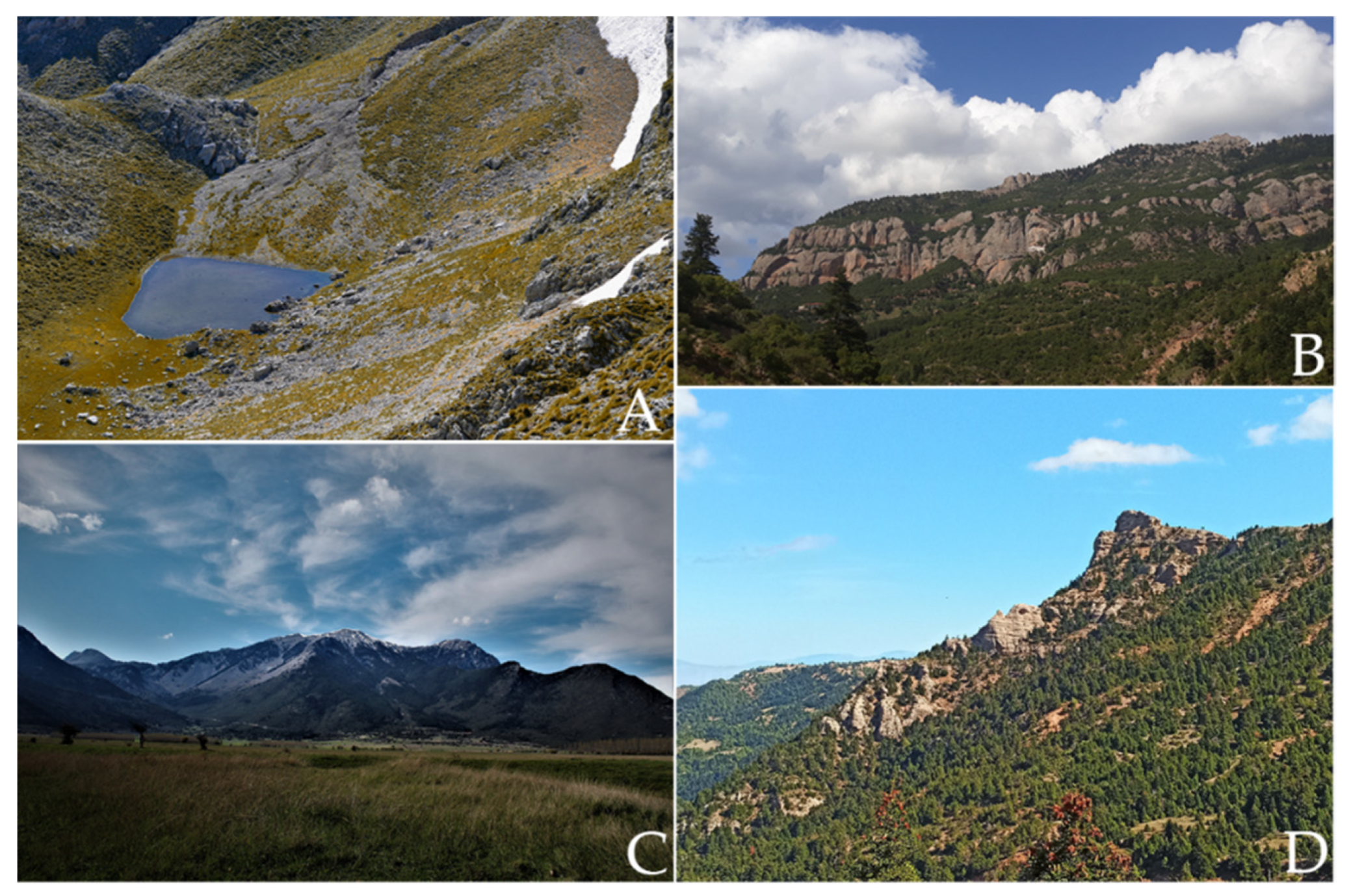
4.7. Mavrolimni (Geosite 24)
Mavrolimni, is a glacial seasonal lake, located on Mount Chelmos at an altitude of 2060 m (37°58′42.43″ N, 22°12′5.15″ E) on bedded limestones of Tripolis zone. To the north of the lake, a moraine ridge was formed due to the movement of glaciers from Psili Korfi or Neraidorachi downstream (
Figure 3A). According to Pope et al. [
42], the formation of the moraine took place during the Middle Pleistocene. The glacial sediments blocked the drainage network resulting in the formation of the alpine lake.
Mavrolimni depicts a combination of two types of geological history, (score of sub-criterion 1.1.–2.5). In terms of its representativeness, it is considered low in relation to the geoheritage of the entire study area (score of sub-criterion 1.2. 2.5). The geological features and processes in this geosite consist of evidence for the existence of glaciers during the last glacial periods and the preservation of glacial geomorphs such as the seasonal alpine lake (score of sub-criterion 1.3. 5). In the past, there were other smaller lakes of this type on Mount Chelmos which today are dry or destroyed and thus Mavrolimni is recognized as the only geosite of this kind (score of sub-criterion 1.4.–10). As for the current state of preservation from human activity and natural processes, this geosite remains intact (score of sub-criterion 1.5. 10).
Rare endemic species of flora (score of sub-criterion 2.1. 10), such as Aquilegia ottonis subsp. ottonis, Achillea umbellata, Dianthus tymphresteus, Saxifraga sibthorpii have been identified around the lake. It is also characterized by high ornithological value. The actual protection status is considered very high throughout the area (score of sub-criterion 2.2. 10).
No important cultural features are associated with this geosite (all cultural criteria are ranked 1). The lake can be seen from the neighboring high peaks (e.g., Neraidorachi) (score of sub-criterion 4.1. 5). It differs to a very high degree from the background due to its aquatic nature in relation to the surrounding rocky environment (score of sub-criterion 4.2. 10).
Visitors do not exceed 5000 per year, as access to the geosite is only possible after hiking on a demanding track (score of sub-criterion 5.1 1) and therefore, it is considered as a local attraction (score of sub-criterion 5.2. 2.5). The official protection of this geosite is international since it belongs to a NATURA 2000 A1 zone (High Peaks of Mount Chelmos-SCI_GR2320002 and SPA_2320013) of Chelmos-Vouraikos National Park (score of sub-criterion 5.3. 1).
There is no use of the site by humans (score of sub-criterion 6.1. 10) and therefore there is no negative impact (score of sub-criterion 6.2. 10). The degree of fragility is considered very high (score of sub-criterion 6.3. 10). No changes are acceptable without the risk of landscape degradation (score of sub-criterion 6.5. 1). The site can be approached only on foot through two different tracks (score of sub-criterion 6.4. 1).
4.8. Mega Spilaio (Geosite 28)
Mega Spilaio geosite is located on the eastern flank of Vouraikos gorge (38°5′25.80″ N, 22°10′28.32″ E) and includes highly elevated peaks (maximum altitude more than 1400 m). The imposing rocks of Mega Spilaio are mainly composed of conglomerates with steep slopes that in some cases form even vertical cliffs with an altitude difference from the riverbed of more than 800 m (
Figure 3B). The conglomerates were formed in alluvial fan systems in two phases during the Middle Pliocene to Middle Pleistocene. In a sandy clay horizon, fossil bones of large mammals were found. The presence of alluvial fan sediments in such a high altitude is attributed to the tectonic setting of the wider area, the secondary extensional tectonism of the Corinth rift and the resulting great uplift rates [
41].
Hence, Mega Spilaio geosite combines different types of geological history (score of sub-criterion 1.1. 5, score of sub-criterion 1.3. 7.5).
Its representativeness for the geoheritage of the geopark is considered moderate (score of sub-criterion 1.2. 5). Kerpini conglomerates geosite (geosite 5) is also a geosite of this category (score of sub-criterion 1.4. 7.5). This outcrop is moderately deteriorated by human activity (construction of the monastery) and natural processes (cavities from the karstification) (score of sub-criterion 1.5.–5).
Mega Spilaio geosite is a place of very high ecological importance (score of sub-criterion 2.1. 10), because of the existence of the stenotopic endemic chasmophyte species Silene conglomeratica, located exclusively in cracks of these specific conglomerates, denoting this way the inseparable relationship between biodiversity and geodiversity. Part of the geosite close to the monastery is protected, while the surrounding outcrops are not (score of sub-criterion 2.2. 5).
The historic monastery of Mega Spilaio was built around 362 AD, in a cavity that had been formed by the erosion of the conglomerates, by two monks and is considered the oldest monastery in Greece. During the 1821 Greek War of Independence, the Monastery was a beacon of resistance against the Otomans (score of sub-criterion 3.2. 10). Every August 15, the monastery celebrates the memory of the Assumption of Virgin Mary (score of sub-criterion 3.1. 2.5).
Due to the large thickness of the sequence, the high and steep slopes and the location of the geosite in higher topographies than the surrounding area, it is easily distinguishable from the regional road Pounta-Kalavryta, from the village of Zachlorou, as well as from the surrounding mountain peaks (score of sub-criterion 4.1. 10). This impressive landscape differs in relation to the background if we consider the canyon of Vouraikos River as the local background (score of sub-criterion 4.2. 7.5).
Visitors exceed 75,000 per year (score of sub-criterion 5.1. 10). Thus, it is considered as an international attraction (score of sub-criterion 5.2. 10). Although it is located close to the NATURA 2000 A3 zone of Vouraikos Gorge, the monastery and the respective outcrops are not included within the protected area. However, the monastery has been declared a protected archaeological site (score of sub-criterion 5.3. 7.5).
The use by humans is considered weak (score of sub-criterion 6.1. 7.5), as the monastery currently does not inflict any further destruction to the geosite (score of sub-criterion 6.2. 1). The degree of fragility of its physical characteristics is considered low regarding the cohesiveness of the conglomerates (score of sub-criterion 6.3. 2.5). Thus, changes are acceptable without the risk of degrading its features (score of sub-criterion 6.5. 10). The geosite is easily accessed through the local Pounta-Kalavryta road, just 10 km before the town of Kalavryta (score of sub-criterion 6.4. 10).
4.9. Ntourntouvana (Geosite 35)
Ntourntouvana (or Pentelia) Peak is located (37°54′51.72″ N, 22°15′11.17″ E) at the southern margins of Mount Chelmos, standing at an altitude of 2109 m (
Figure 3C). It develops on Cretaceous neritic limestones of Tripolis zone which are in tectonic contact with thin-bedded white dolomites. Rudists and other bivalve shells can be macroscopically observed in the limestone outcrops. In these intensively karstified limestones one of the largest and most important potholes of the geopark area the “Hole of Feneos” (maximum depth 130 m) is developing. This geosite therefore reflects a large part of the geological history of Mount Chelmos (score of sub-criterion 1.1. 5, score of sub-criterion 1.3. 10).
It is a place with high representativeness for the geoheritage of the geopark (score of sub-criterion 1.2. 7.5). Two more high peaks of Chelmos Mt have been characterized as geosites (Geosite 34: Psili Korfi and Geosite 37: Madero) (score of sub-criterion 1.4. 5). The condition of the geosite, as far as both human activity and natural processes are concerned, is characterized as intact (score of sub-criterion 1.5. 10).
It is a geosite rich in endemic species of mountain-Mediterranean meadows (genus Nardus), chasmophytic vegetation and mountain tea (Sideritis sclandestina subsp. peloponnesica endemic to Peloponnese) (score of sub-criterion 2.1. 5). The existing protection and conservation status are high throughout the Ntourntouvana area (score of sub-criterion 2.2. 10).
This geosite does not display important features of cultural heritage (all cultural criteria are scored 1). Due to its high altitude, this geosite can be observed from many surrounding localities (score of sub-criterion 4.1. 10). Due to the absence of woody plants at Ntourntouvana Peak, the geosite differs from the surrounding area, where forests of black pines and firs grow (score of sub-criterion 4.2. 7.5).
Visitors do not exceed 5000 per year and are limited to mountaineers who hike across its tracks (score of sub-criterion 5.1. 1). Thus, it is considered as a local attraction (score of sub-criterion 5.2. 2.5). Officially, it is included in zone C of the NATURA 2000 area of Chelmos-Vouraikos National Park (score of sub-criterion 5.3. 1).
There is no use of the area by humans (score of both sub-criteria 6.1., 6.2. 10). Due to the rocky substrate, it does not have any degree of fragility (score of sub-criterion 6.3. 1). Therefore, small changes are acceptable without the risk of degrading its physical characteristics (score of sub-criterion 6.5. 10). There are two tracks to approach the site (score of sub-criterion 6.4. 1).
4.10. Eroded Conglomerates (Geosite 38)
East of the monastery of Megalo Spilaio, the Εroded Conglomerates geosite is developing (38°5′0.37″ N, 22°11′4.26″ E). It is composed of different Lower-Middle Pleistocene cohesive conglomerates. They were deposited as fan deposits of larger or smaller rivers [
54]. Due to the high-altitude, strong winds dominate the microclimate. They erode the cohesive conglomerates forming surface geomorphs, resulting in an impressive landscape (
Figure 3D). The Eroded conglomerates geosite depicts a combination of two types of geological history (score of sub-criterion 1.1. 2.5).
It is not considered representative for the geoheritage of the geopark (score of sub-criterion 1.2. 1), while geodiversity is characterized as low (score of sub-criterion 1.3. 2.5). Along with the Kerpini Conglomerates geosite, they are considered as two geosites depicting similar processes (score of sub-criterion 1.4. 7.5). The continuous erosion of wind and water deforms slowly the geosite. However, this process is considered slow and natural. Moreover, this is what characterizes this geosite. For this reason, it is characterized as weakly deteriorated (score of sub-criterion 1.5. 7.5).
The ornithological value of the site is considered important (score of sub-criterion 2.1. 10), however, the area is not protected (score of sub-criterion 2.2. 1).
No cultural heritage features are related to this specific geosite (all cultural criteria are scored 1). This geosite can be seen from two points on the local road network (score of sub-criterion 4.1. 5). It shows a moderate difference from the rest of the landscape due to the presence of fir trees (score of sub-criterion 4.2. 5). The visitors are limited to those who hike across the Kalavryta to Mega Spilaio georoute (total length 36.5 km). They do not exceed 5000 per year (score of sub-criterion 5.1. 1), and thus it is considered a local attraction (score of sub-criterion 5.2. 2.5). There is no official protection status for this geosite (score of sub-criterion 5.3. 10).
Its use is characterized as moderate due to grazing as well as to the presence of small farming facilities for animal watering (score of sub-criterion 6.1. 5), which alter the aesthetics of the landscape (score of sub-criterion 6.2. 5). In addition, this is a geosite with low fragility (score of sub-criterion 6.3. 2.5) and therefore changes are acceptable (to a moderate degree) without the risk of landscape degradation (score of sub-criterion 6.5. 5). The geosite can be accessed either using the aforementioned track, or from the Waters of Styx-Mega Spilaio georoute. Furthermore, visitors can approach the place by car using a forest road (3.6 km). However, this road is not free to public, and passage is allowed only after a special permit (score of sub-criterion 6.4. 2.5).
4.11. Synthesis of Results
As far as the scientific criteria are concerned, the scores range from 2.1 to 9.5. More specifically, the highest values are presented by Geosite 1 (Niamata) (9.5) and Geosite 23 (Lousoi polje) (8.5). This high score is attributed to the depiction of a large part of the geological history of the study area.
The ecological criteria cover the full scores’ range (1 to 10). Geosites 2 (Portes–Triklia), 5 (Kerpini conglomerates), 11 (the Cave of the Lakes) and 24 (Mavrolimni) present the highest score (10). Geosites 20 and 34 (Water of Styx and Psili Korfi, respectively) are classified slightly lower (8.8). These geosites present very high ecological importance in combination to their high protection status.
The rating of the cultural criteria ranges from low to medium (1 to 5.9). More specifically, Geosite 11 (Mega Spilaio) presents the highest score (5.9) because of its very high religious interest. Geosite 8 (Agia Lavra) follows (5.5) with moderate historical and religious interest. Geosite 17 (Doxa lake) with 4.6 is also at the same score level mainly because of its religious and historical significance. Finally, Geosite 33 (Pausanias Vine), with 3.6, is considered a geosite of mainly historical interest.
The aesthetic criteria score shows a wide range as well (1 to 10). Geosites 11 and 17, Cave of the Lakes and Doxa Lake, respectively, present the highest value, (10). Geosite 11 (Cave of the Lakes), although it cannot be observed from other locations being underground, is one of the most popular geosites of the geopark with amazing speleothems. Geosite 17 (Lake Doxa) is highly visible from many viewpoints of the surrounding area and has a very high landscape diversity. Geosites 2 (Portes–Triklia), 7 (Tectonic Graben of Kalavryta), 28 (Mega Spilaio) and 35 (Ntourntouvana) present also a very high score (8.8).
The score of the economic criteria varies from 1 to 10. Geosite 7 (Tectonic Graben of Kalavryta) has been scored with 10. Geosite 28 (Mega Spilaio) also presents a very high score (9.2). The exceptionally high scores of the aforementioned geosites are mainly attributed to their very high visibility.
The score of the criteria for potential use ranges from 3.9 to 9.5. Geosite 13 (Lousoi sinkholes) bear the highest score for this criterion (9.5), followed by geosites 7 and 36 (Tectonic graben of Kalavryta and Chelonospilia).
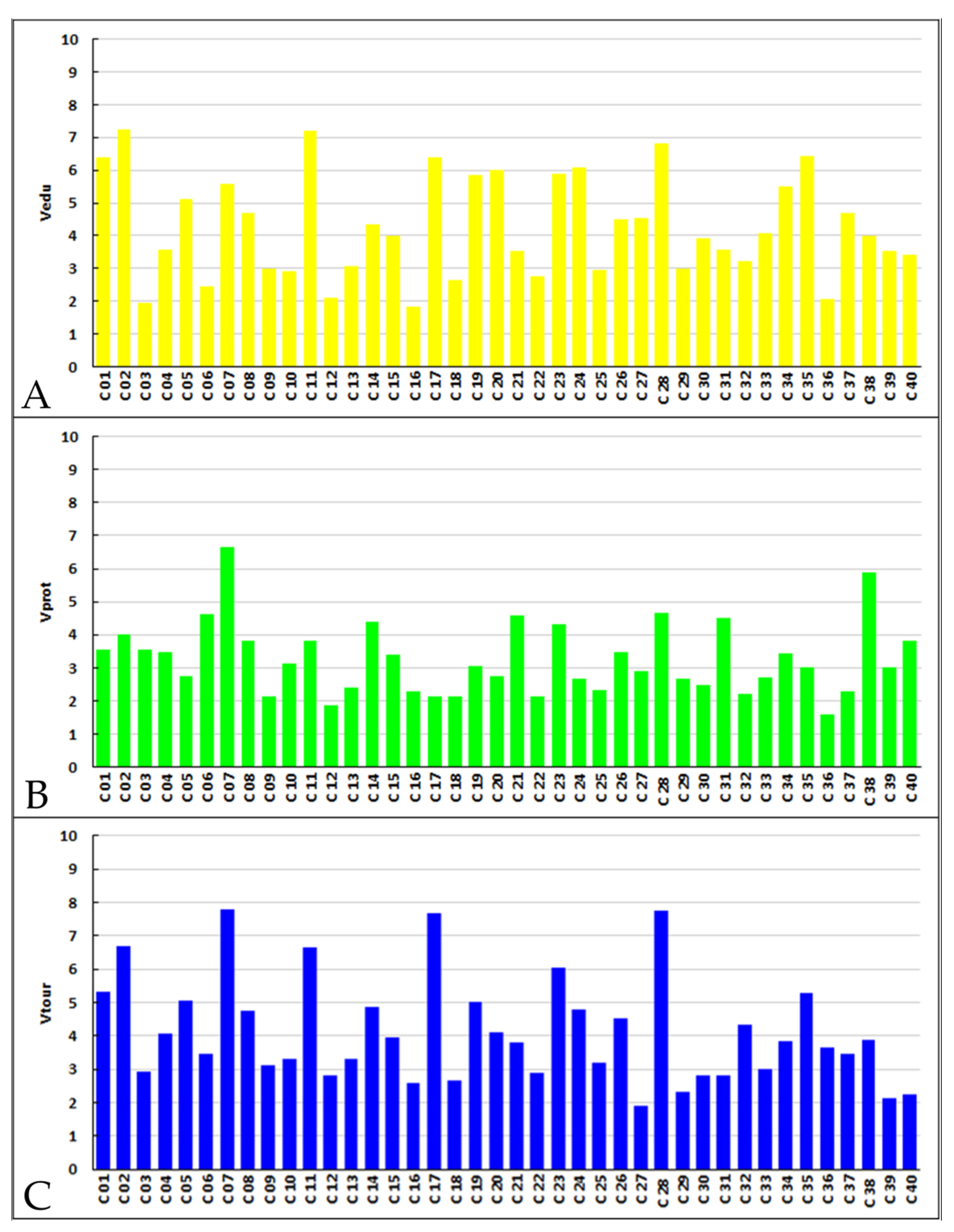
As suitable geosites for educational activities are considered those geosites with values of V
edu exceeding 6 (
Figure 4). These are (in descending order) the geosites Portes-Triklia (C 02, V
edu = 7.3), the Cave of the Lakes (C 11, V
edu = 7.2), Mega Spilaio (C 28, V
edu = 6.8), Ntountouvana (C 35, V
edu = 6.5), Niamata (C 01, V
edu = 6.4), Doxa lake (C 17, V
edu = 6.4) and Mavrolimni (C 24, V
edu = 6.1). Geosites with moderate educational value (4 ≥ V
edu ≤ 6) include the geosites (in descending order) Water of Styx (C 20, V
edu = 6), Lousoi polje (C 23, V
edu = 5.9), Tsivlos lake (C 19, V
edu = 5.9), the Tectonic Graben of Kalavryta (C 07, V
edu = 5.6), Psili Korfi (C 34, V
edu = 5.5), Kerpini conglomerates (C 05, V
edu = 5.1), Water of Styx (C 20, V
edu = 5.1), Agia Lavra (C 08, V
edu = 4.7), Madero (C 37, V
edu = 4.7), Valvousi (C 26, V
edu = 4.5), Keramidaki (C 27, V
edu = 4.5), Aroanios springs (C 14, V
edu = 4.4), Pausanias Vine (C 33, V
edu = 4.1), Mati tou Ladona (C 15, V
edu = 4) and the Eroded conglomerates (C 38, V
edu = 4). Geosites Ntourntouvana, Psili korfi, Water of Styx and Madero remain unused for educational purposes mainly as access to these sites is difficult.
Regarding the geotouristic value of the geosites index V
tour is considered (
Figure 4). The highest values are presented by Tectonic Graben of Kalavryta (C 07, V
tour = 7.8), Mega Spilaio (C 28, V
tour = 7.7), Doxa lake (C 17, V
tour = 7.7), the Cave of the Lakes (C 11, V
tour = 6.7), Portes–Triklia (C 02, V
tour = 6.7) and Lousoi polje (C 23, V
tour = 6). Lower values (4 ≥ V
tour < 6) are presented by the following geosites (in descending order): Niamata (C 01, V
tour = 5.3), Kerpini conglomerates (C 05, V
tour = 5.1), Tsivlos lake (C 19, V
tour = 5), Aroanios springs (C 14, V
tour = 4.9), Agia Lavra (C 08, V
tour = 4.8), Mavrolimni (C 24, V
tour = 4.8), Valvousi (C 26, V
tour = 4.5), Valimi landslides (C 32, V
tour = 4.3), Ntourntouvana (C 35, V
tour = 5.3), Waters of Styx (C 20, V
tour = 4.1), Trapeza Marine terrace (C 04, V
tour = 4.1) and Mati Tou Ladona (C 15, V
tour = 4). Ntourntouvana and Water of Styx geosites are not yet touristically exploited due to difficult access.
Geosites that according to the V
prot index, show the greatest need for protection are the Tectonic Graben of Kalavryta (C 07, V
prot = 6.7) and the Eroded conglomerates (C 38, V
prot = 5.9), (
Figure 4). The need for protection of the Tectonic Graben of Kalavryta Geosite concerns the very high human activity (farming, industry, etc.) which is spotted in the wider area. The Eroded conglomerates geosite needs protection from overgrazing that has caused alteration in the landscape.
As far as the ecological risk factor (Fecol) is concerned, the highest value is held by the Eroded conglomerates geosite (C 38, Fecol = 10). The Fecol is also particularly high in the Tectonic Graben of Kalavryta (C 07, Fecol = 5). Therefore, there is an urgent need for official protection in these geosites.
5. Discussion
Over the last decades, geoconservation [
65] approaches have become very popular, contributing significantly as an important component of nature conservation practices [
66]. Deterioration of the environment driven by the constantly increasing human pressure to our planet has made clear the need to record, protect and promote not only biodiversity but geodiversity as well [
67]. Preserving geological heritage has thus become a key factor for future legislation and policies that would allow the more effective management of the natural environment through the protection of geosites [
68]. To achieve these goals, geosite conservation practices need to be implemented to limit anthropogenic and natural deterioration or destruction [
69]. Nevertheless, to plan or take specific geoconservation measures for geosites and particularly in places where geoconservation can be enhanced such as geoparks, geosite assessments need to be implemented first to identify their value, possible threats and the need for protection [
69,
70].
Except for geoconservation, geoparks in their effort to promote sustainable development and economic benefits for local communities through geotourism and education, have also as main goals the connection of nature with people and the connection of geodiversity with biodiversity, cultural heritage and local communities [
68,
71,
72]. Through geotouristic and educational activities organised by the geoparks, geoscientific knowledge and geoconservation concepts are transferred to the public [
72].
To succeed in all these, a more holistic approach for the sustainable management of geoparks is required, that will combine sustainable development activities with effective geoconservation which will promote geoheritage values [
71]. The first step, however, before geopark management approaches are developed, is the assessment of a geopark’s geosites where scientific, cultural, ecological and economic criteria are considered. Thus, employing a method for the assessment of geosites such as the Fassoulas et al. [
19] method, which was particularly developed to meet the needs of UGGps, is considered as a good starting point for the management planning of the Chelmos-Vouraikos UGGp.
The evaluation method of Fassoulas et al. [
19] has provided very detailed information regarding the value of each geosite and its needs. It takes into account all the existing parameters so that a geosite can be scored impartially and completely. Τhe large range of the grading system (1 to 10) provides the opportunity for a more detailed assessment of the criteria.
Nevertheless, during the evaluation of the results after the application of this methodology, some minor discrepancies became apparent. Concerning the aesthetic criteria (criteria 4.1. and 4.2.), in the case of caves and generally underground geosites, some improvements are certainly needed. We have to stress here that during the development and testing of the methodology [
19], no caves were used under the assessment process and thus no certain specifications are provided for their scoring. In our case, particular caves present low visibility and for this reason they bear a low score on this criterion. However, these geosites are often very popular and aesthetically enhanced and thus this criterion scoring gives a misleading impression. A characteristic example is the Cave of the Lakes geosite. Hence, application of another evaluation methodology which was created for karst systems, by Li et al. [
22] was put under consideration. However, this methodology was difficult to be carried out in this case, due to the fact that a lot of different geosites, such as karstic geomorphs, gorges and rivers, should be taken into account as well. Therefore, the above method could have been applied only for these geosites, since most of the geosites of Chelmos-Vouraikos UGGp do not fall into the above category. Thus, this method is not appropriate for the evaluation of all geosites of the geopark but just for a number of them. To overpass the problem with Fassoulas et al. [
19] methodology, if criteria 4.1 and 4.2 are treated for caves under their strict meaning (number of view points, or landscape difference), we should consider the underground aesthetic image in a broader sense as it happens with the open air. Thus, the variety of the cave system (number of halls, length, different levels) could count as the number of viewpoints, whereas the landscape difference could, in this case, represent the wealth of speleothems (i.e., Stalagmites, stalactites, gours, curtains, etc.).
A similar problem is encountered in the cultural criteria which are divided into four sub-criteria. A geosite may bear a high score in one sub-criterion because of its exceptional value, however it could be scored low in the rest. As a result, the final score of this criterion is low for this specific geosite even if the value of one of the sub-criteria is exceptionally high. A characteristic example is the Water of Styx geosite which has a very important mythological heritage but has low values of ethics, history and art. It thus presents a final low score on this criterion which undermines the undeniably high cultural value of this geosite. Thus, a more careful inspection and consideration in the broader sense of each of the cultural sub-criteria separately must be taken into account when implementing this methodology, or maybe the introduction of an additional one that could refer to intangible cultural heritage might also be useful.
Finally, the scoring for the number of visitors is easy to be calculated in the case that ticket offices exist (e.g., Cave of the Lakes). There, the number of visitors is recorded with accuracy. However, in geosites where the number of visitors cannot be calculated with absolute values but only approximately, the score of this criterion is questionable. Thus, an additional visitor’s estimation system has to be considered under scoring.
The criteria focus on a regional level, which helps to identify the priorities of the geopark. Geosites that have high values in the touristic or educational index should be utilized in corresponding activities. Similarly, the geosites that have a high index for the need of protection are the ones that face higher risks, and it is deemed necessary to implement actions to protect them. Geosites with great touristic and educational value that are already exploited for corresponding activities, it is necessary to be maintained at this level. Conversely, in geosites with high touristic and education importance that are not exploited to date, actions such as opening of new paths or construction of funiculars etc, must be taken, so that they can be approached safely by tourists and students. Characteristic examples are the geosites Water of Styx and Psili Korfi at Chelmos Mt. According to their assessment they are geosites of great interest that certainly need enhancement. For this reason, the Management Body of Chelmos-Vouraikos, after evaluating the results of the assessment, has already planned during the following year a series of interventions for all the geosites found on Chelmos Mt (including Water of Styx and Psili Korfi) to improve accessibility to the geosites and enhance their promotion including activities in collaboration with the local Ski Center, even for people that will not be able to access the actual sites. This is a classic example of how the assessment of geosites can help the managing authorities to prioritize the needs of their geoparks. Moreover, in geosites with high protection-need, more intense protection measures need to be taken. For instance, livestock and respective facilities should be removed, as well as restrictions on crop cultivation within these geosites should be applied.
The immediate next aim of this research is to improve the existing evaluation method. Additionally, an average score for each index or criteria could be calculated for all the geosites of the evaluated geopark. If such a methodology is implemented by different geoparks, a comparison between them would be possible. This comparison would be helpful for the further development of all geoparks, which have as their main objective the conservation of the geological heritage and the promotion of sustainable development. In addition, by using a single rating system by different geoparks, it would be possible to propose response measures for low-scored geosites. Utilization of the above measures would be helpful for other geoparks as well facing similar difficulties.


 ,
, 


