

Analysis of Flooding Vulnerability in Informal Settlements Literature: Mapping and Research Agenda


Abstract
:1. Introduction
- What are the existing research trends in flooding among informal settlements globally?
- What have been the main domains of research, and how has flooding within this socioeconomic group been studied?
- What constitutes the key knowledge areas in South African informal settlements?
- What are the important research gaps and areas where further research is needed?
2. Background and Theoretical Foundations
2.1. Historical Overview of South Africa’s Informal Settlement and Marginalization
2.2. Legislative Framework on Human Settlement in South Africa
3. Materials and Methods
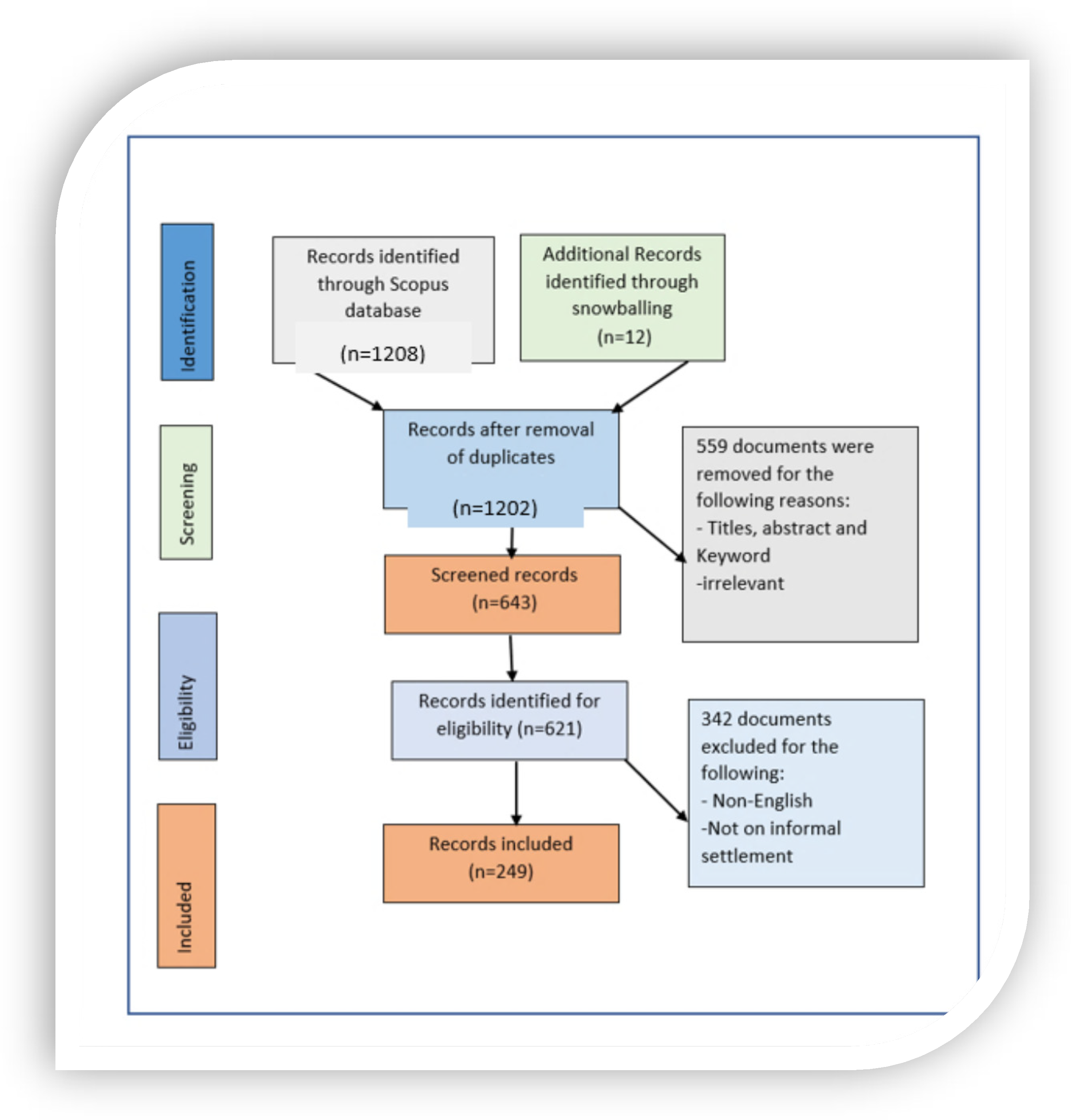
Databases, Keywords, and Inclusion Criteria
4. Results
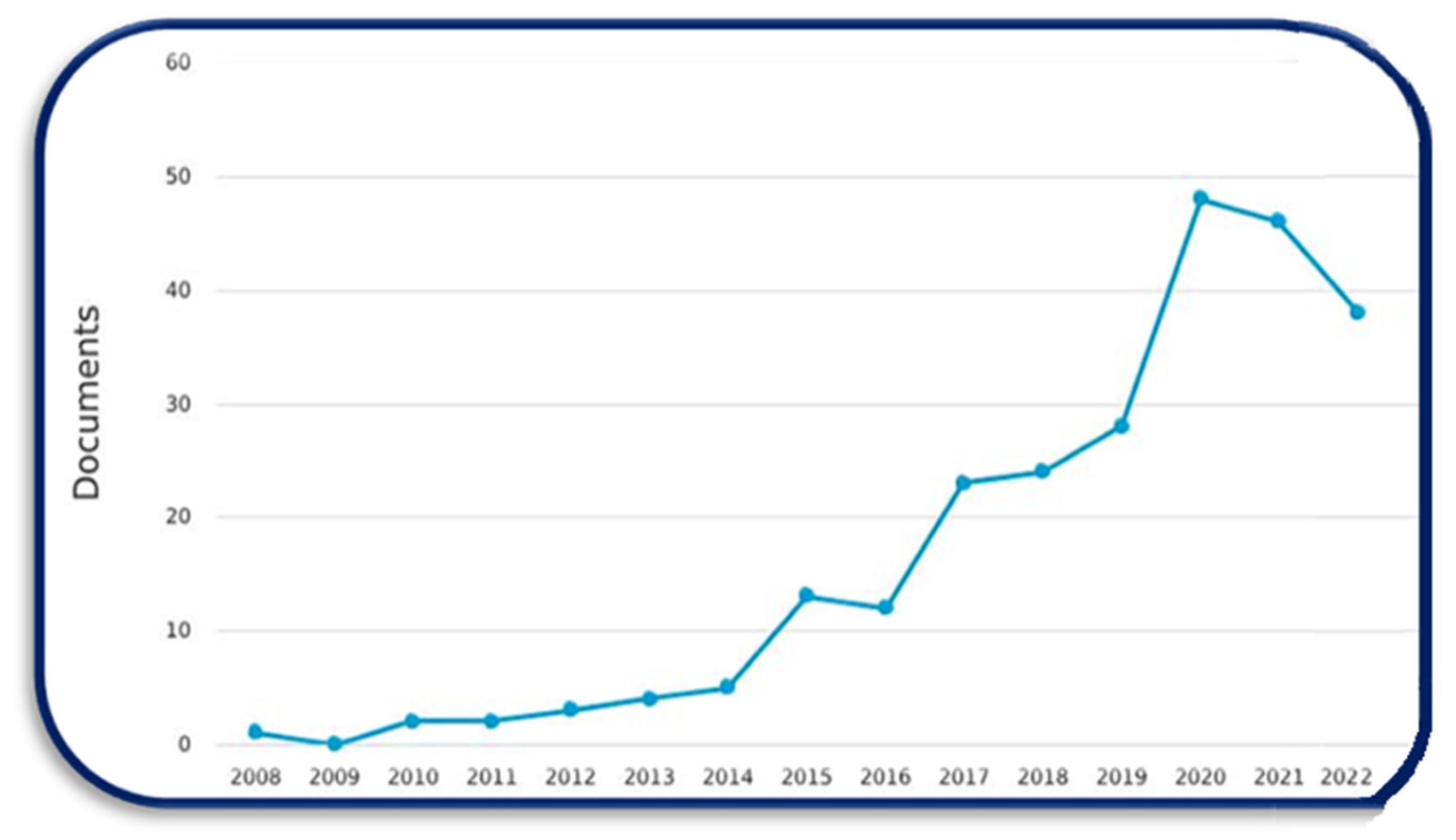
4.1. Global Mapping
4.2. Spatial Distribution of Articles
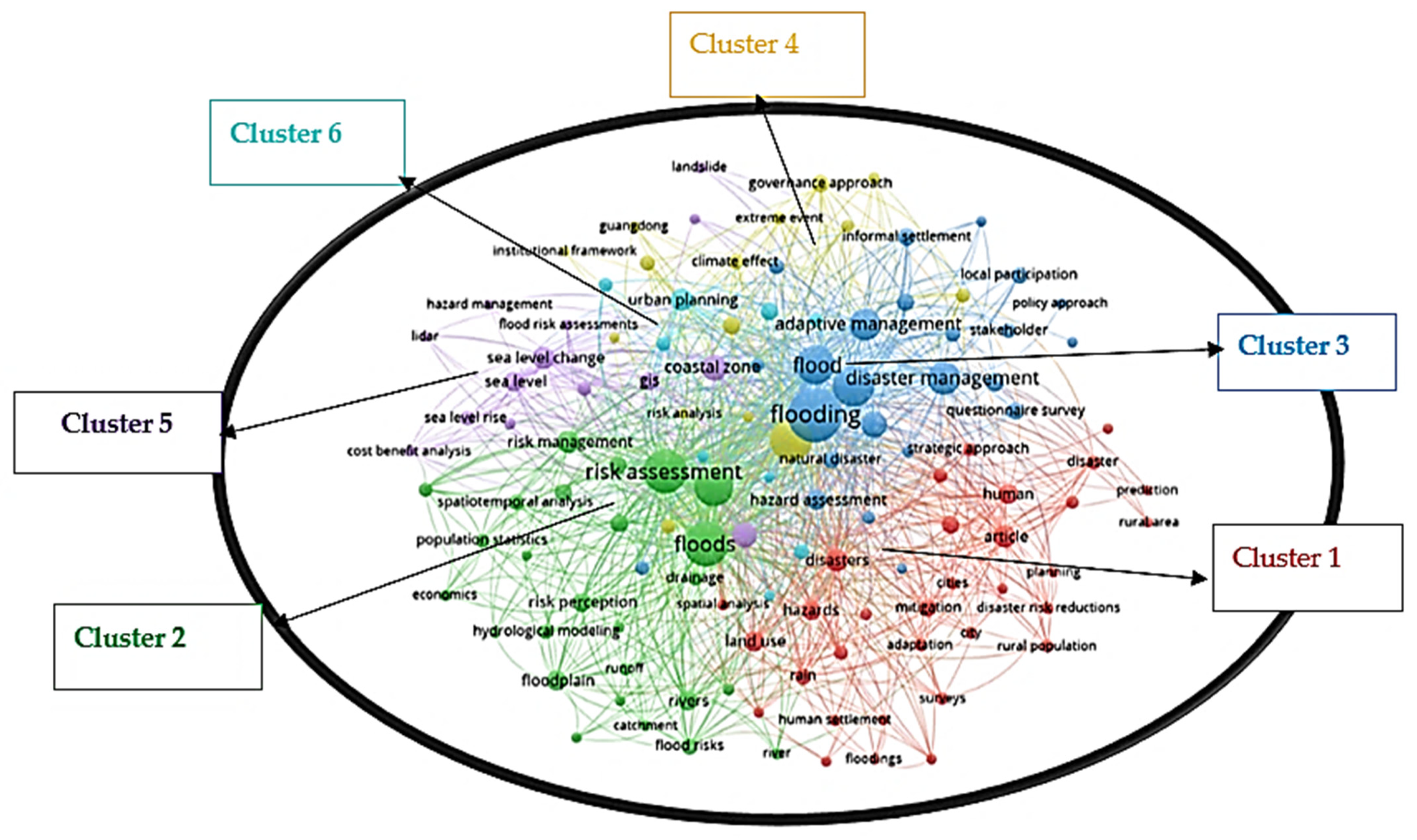
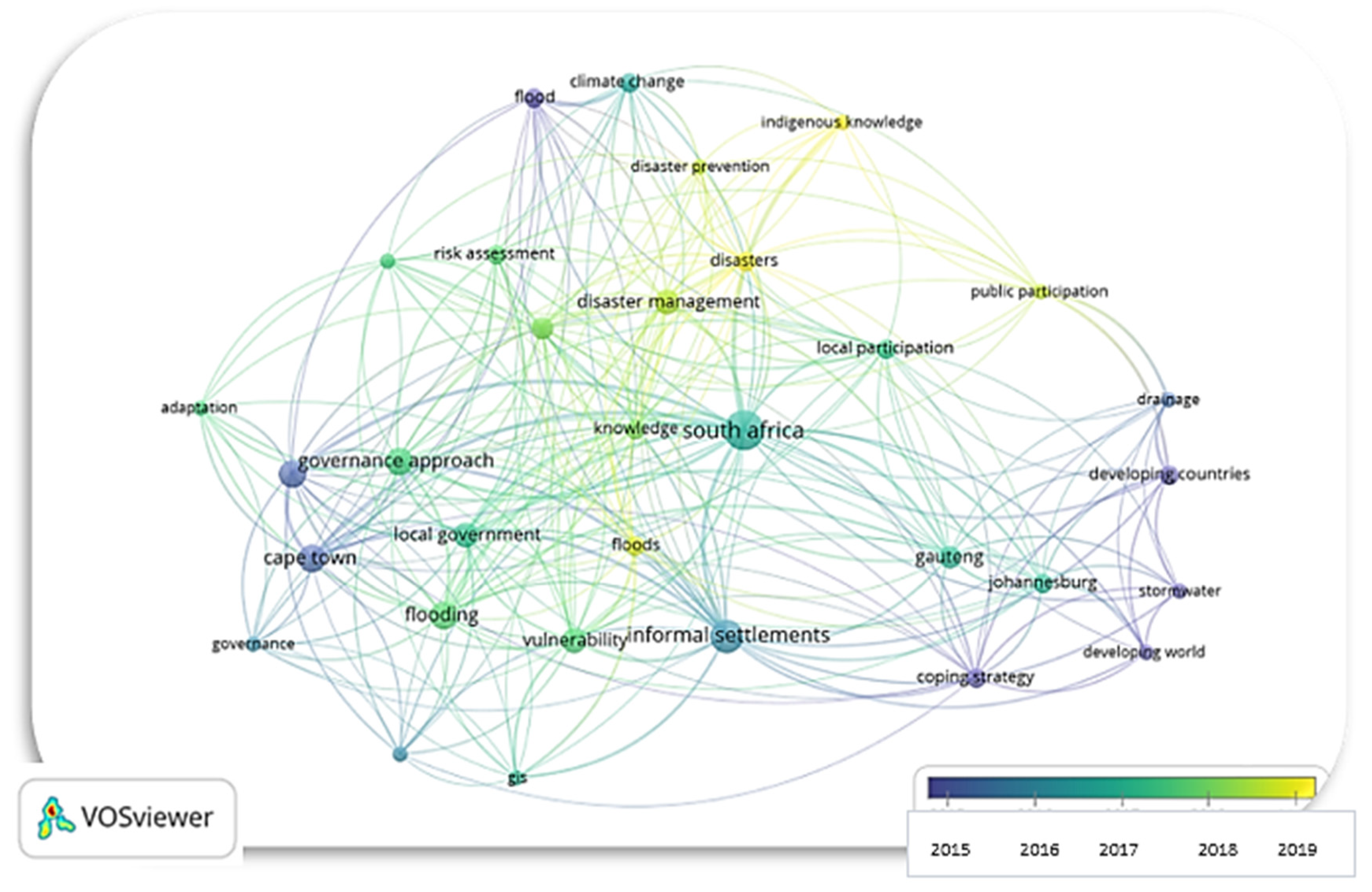
4.3. Keyword Co-Occurrence
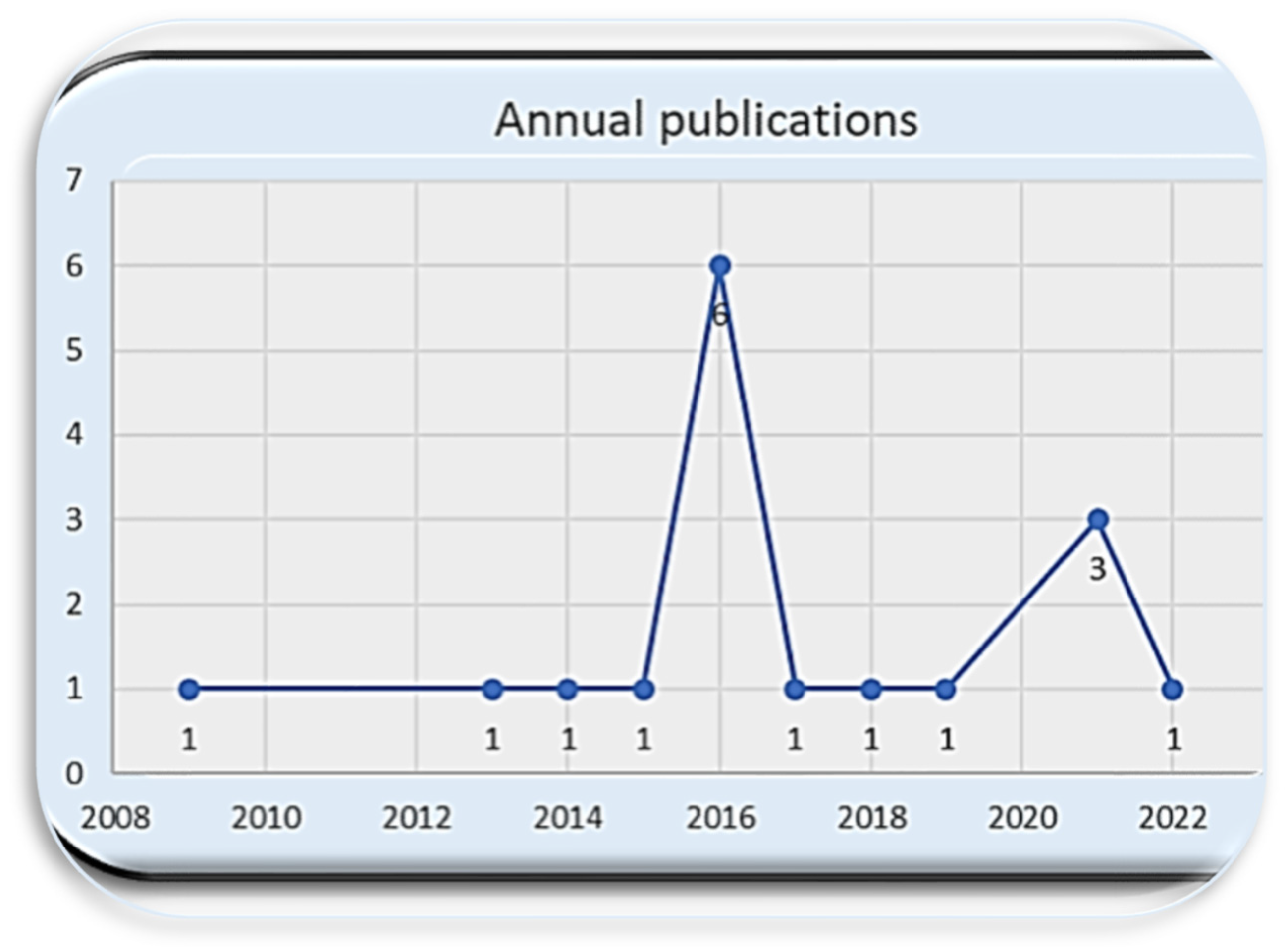
4.4. Flooding in Informal Settlements of South Africa
4.5. Keyword Co-Occurrence Analysis
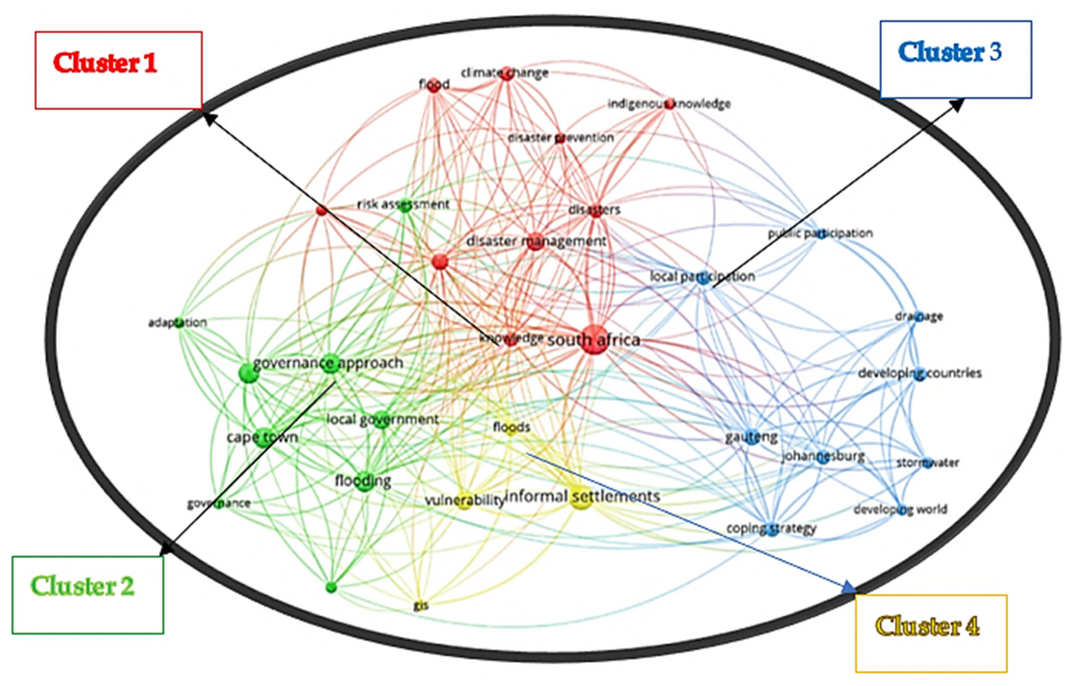
Overview of the Connections between the Clusters
5. Discussion
5.1. Strengthening the Resiliency of Informal Settlements
5.2. Housing and Infrastructure Upgrading
5.3. Mapping/Modeling Levels of Flood Vulnerability
5.4. Indigenous Knowledge and Mapping
5.5. Green Infrastructure
5.6. Community Participation
5.7. Suggested Areas of Future Research
5.8. Summary
5.9. Limitations
6. Conclusions
Author Contributions
Funding
Institutional Review Board Statement
Informed Consent Statement
Data Availability Statement
Conflicts of Interest
References
- Abunyewah, Matthew, Thayaparan Gajendran, Kim Maund, and Seth Asare Okyere. 2020. Strengthening the information deficit model for disaster preparedness: Mediating and moderating effects of community participation. International Journal of Disaster Risk Reduction 46: 101492. [Google Scholar] [CrossRef]
- Adelekan, Ibidun. 2010. Vulnerability of poor urban coastal communities to flooding in Lagos, Nigeria. Environment & Urbanization 22: 433–50. [Google Scholar]
- Adelekan, Ibidun, Cassidy Johnson, Mtafu Manda, David E. Matyas, Blessing U. Mberu, Susan Parnell, Mark Pelling, David Satterthwaite, and Janani Vivekananda. 2015. Disaster risk and its reduction: An agenda for urban Africa. International Development Planning Review 37: 33–43. [Google Scholar] [CrossRef] [Green Version]
- Alfieri, Lorenzo, Luc Feyen, and Giuliano di Baldassarre. 2016. Increasing flood risk under climate change: A pan-European assessment of the benefits of four adaptation strategies. Climatic Change 136: 507–21. [Google Scholar] [CrossRef] [Green Version]
- Amoako, Clifford, and Daniel Kweku Baah Inkoom. 2018. The production of flood vulnerability in Accra, Ghana: Re-thinking flooding and informal urbanisation. Urban Studies 55: 2903–22. [Google Scholar] [CrossRef]
- Amoako, Clifford, and Emmanuel Frimpong Boamah. 2015. The three-dimensional causes of flooding in Accra, Ghana. International Journal of Urban Sustainable Development 7: 109–29. [Google Scholar] [CrossRef]
- Baker, Judy. 2012. Climate Change, Disaster Risk, and the Urban Poor: Cities Building Resilience for a Changing World. Washington, DC: World Bank Publications. [Google Scholar]
- Baldassarre, Giuliano Di, Alberto Montanari, Harry F. Lins, Demetris Koutsoyiannis, Luigia Brandimarte, and Günter Blöschl. 2010. Flood fatalities in Africa: From diagnosis to mitigation. Geophysical Research Letters 37: L22402. [Google Scholar] [CrossRef] [Green Version]
- Berrisford, Stephen. 2011. Unravelling Apartheid Spatial Planning Legislation in South Africa. Urban Forum 22: 247–63. [Google Scholar] [CrossRef]
- Botha, Doret, and Dewald Van Niekerk. 2013. Views from the Frontline: A Critical Assessment of Local Risk Governance in South Africa. Jàmbá: Journal of Disaster Risk Studies 5: 101102. [Google Scholar] [CrossRef]
- Busayo, Emmanuel Tolulope, Ahmed Mukalazi Kalumba, Gbenga Abayomi Afuye, Adeyemi Oludapo Olusola, Olusola Oluwayemisi Ololade, and Israel Ropo Orimoloye. 2022. Rediscovering South Africa: Flood disaster risk management through ecosystem-based adaptation. Environmental and Sustainability Indicators 14: 100175. [Google Scholar] [CrossRef]
- Desai, Bina, Andrew Maskrey, Pascal Peduzzi, Andrea de Bono, and Christian Herold. 2015. Making Development Sustainable: The Future of Disaster Risk Management, Global Assessment Report on Disaster Risk Reduction. Available online: https://www.preventionweb.net/english/hyogo/gar/2015/en/gar-pdf/GAR2015_EN.pdf (accessed on 10 August 2022).
- Desportes, Isabelle, Michaela Hordijk, and Joy Waddell. 2016. Improving flood risk governance through multi-stakeholder collaboration: A case study of Sweet Home informal settlement, Cape Town. South African Geographical Journal = Suid-Afrikaanse Geografiese Tydskrif 98: 61–83. [Google Scholar] [CrossRef]
- DOH. 1997. Urban Development Policy. Department of Housing, Pretoria. Available online: http://www.dhs.gov.za/sites/default/files/legislation/Policies_Housing_White_Paper.pdf (accessed on 13 September 2022).
- Donthu, Naveen, Satish Kumar, and Debidutta Pattnaik. 2020. Forty-five years of Journal of Business Research: A bibliometric analysis. Journal of Business Research 109: 1–14. [Google Scholar] [CrossRef]
- Douglas, Ian. 2018. The challenge of urban poverty for the use of green infrastructure on floodplains and wetlands to reduce flood impacts in intertropical Africa. Landscape and Urban Planning 180: 262–72. [Google Scholar] [CrossRef]
- Douglas, Ian, Kurshid Alam, Marianne Maghenda, Yasmin Mcdonnell, Louise Mclean, and Jack B. Campbell. 2008. Unjust waters: Climate change, flooding and the urban poor in Africa. Environment & Urbanization 20: 187–205. [Google Scholar]
- Drivdal, Laura. 2016. Flooding in Cape Town’s informal settlements: Conditions for community leaders to work towards adaptation. South African Geographical Journal = Suid-Afrikaanse Geografiese Tydskrif 98: 21–36. [Google Scholar] [CrossRef]
- Dube, Kaitano. 2022. EXPERT Opinion: Flooding Events in Kwazulu Natal and Eastern Cape and Implications for Disaster Management in South Africa—Vaal University of Technology. Available online: https://www.vut.ac.za/expert-opinion-flooding-events-in-kwazulu-natal-and-eastern-cape-and-implications-for-disaster-management-in-south-africa/ (accessed on 14 September 2022).
- Dube, Kaitano, Godwell Nhamo, and David Chikodzi. 2021. Flooding Trends and Their Impacts on Coastal Communities of Western Cape Province, South Africa. GeoJournal 87: 453–68. [Google Scholar] [CrossRef]
- Fatti, Christina Elizabeth, and Zarina Patel. 2013. Perceptions and responses to urban flood risk: Implications for climate governance in the South. Applied Geography 36: 13–22. [Google Scholar] [CrossRef]
- Gough, Katherine V., Paul William Kojo Yankson, Robert L. Wilby, Ebenezer Forkuo Amankwaa, Mercy A. Abarike, Samuel Nii Ardey Codjoe, Paula L. Griffiths, Raymond Abudu Kasei, Sam Kayaga, and Cuthbert Kaba Nabilse. 2019. Vulnerability to extreme weather events in cities: Implications for infrastructure and livelihoods. Journal of the British Academy 7: 155–81. [Google Scholar] [CrossRef]
- Guelke, Adrian. 2004. Politics in South Africa: From Mandela to Mbeki by TOM LODGE Cape Town: David Philip, 2002. Pp. 314. £19.95 (pbk.). The Journal of Modern African Studies 42: 158–59. [Google Scholar] [CrossRef]
- Gu, Zhouyang, Fanchen Meng, and Muhammad Farrukh. 2021. Mapping the Research on Knowledge Transfer: A Scientometrics Approach. IEEE Access 9: 34647–59. [Google Scholar] [CrossRef]
- Haque, Anika Nasra. 2021. Climate risk responses and the urban poor in the global South: The case of Dhaka’s flood risk in the low-income settlements. International Journal of Disaster Risk Reduction 64: 102534. [Google Scholar] [CrossRef]
- Hu, Wanjie, Jianjun Dong, Bon-Gang Hwang, Rui Ren, and Zhilong Chen. 2019. A Scientometrics Review on City Logistics Literature: Research Trends, Advanced Theory and Practice. Sustainability 11: 2724. [Google Scholar] [CrossRef]
- Jongman, Brenden, Philip J. Ward, and Jeroen C. Aerts. 2012. Global exposure to river and coastal flooding: Long term trends and changes. Global Environmental Change 22: 823–35. [Google Scholar] [CrossRef]
- Karamouz, Mohammad, Ali Razmi, Sara Nazif, and Zahra Zahmatkesh. 2017. Integration of inland and coastal storms for flood hazard assessment using a distributed hydrologic model. Environmental Earth Sciences 76: 395. [Google Scholar] [CrossRef]
- Khalid, Ishaq, and Elsa Maishman. 2022. Nigeria Floods: ‘Overwhelming’ Disaster Leaves More than 600 People Dead—BBC News. BBC News. Available online: https://www.bbc.com/news/world-africa-63280518 (accessed on 25 September 2022).
- Klijn, Frans, Heidi Kreibich, Hans de Moel, and Edmund C. Penning-Rowsell. 2015. Adaptive flood risk management planning based on a comprehensive flood risk conceptualisation. Mitigation and Adaptation Strategies for Global Change 20: 845–64. [Google Scholar] [CrossRef] [Green Version]
- Kundzewicz, Zbigniew W., Buda Su, Yanjun Wang, Guojie Wang, Guofu Wang, Jinlong Huang, and Tong Jiang. 2019. Flood risk in a range of spatial perspectives—From global to local scales. Natural Hazards and Earth System Sciences 19: 1319–28. [Google Scholar] [CrossRef] [Green Version]
- Kundzewicz, Zbigniew W., Shinjiro Kanae, Sonia I. Seneviratne, John Handmer, Neville Nicholls, Pascal Peduzzi, Reinhard Mechler, Laurens M. Bouwer, Nigel Arnell, Katharine Mach, and et al. 2014. Flood risk and climate change: Global and regional perspectives. Hydrological Sciences Journal 59: 1–28. [Google Scholar] [CrossRef] [Green Version]
- Leduka, Resetselemang Clement. 2008. Unlawful Occupation: Informal Settlements and Urban Policy in South Africa and Brazil. Urban Forum 19: 105–7. [Google Scholar] [CrossRef]
- Letsoalo, Essy M., and Mabjoalo Jane Thupana. 2013. The repeal of the land acts: The challenge of land reform policies in South Africa. Social Dynamics 39: 298–307. [Google Scholar] [CrossRef]
- Mapedza, Everisto, Tambudzai Rashirayi, Cai Xueliang, Alemseged Tamiru Haile, Barbara van Koppen, Mukelabai Ndiyoi, and Sonali Senaratna Sellamuttu. 2022. Indigenous Knowledge Systems for the management of the Barotse Flood Plain in Zambia and their implications for policy and practice in the developing world. In Current Directions in Water Scarcity Research. Amsterdam: Elsevier, vol. 4, pp. 209–25. [Google Scholar]
- Melore, Tamirat W., and Verna Nel. 2020. Resilience of Informal Settlements to Climate Change in the Mountainous Areas of Konso, Ethiopia and QwaQwa, South Africa. Jàmbá Journal of Disaster Risk Studies 12: 778. [Google Scholar] [CrossRef]
- Membele, Garikai Martin, Maheshvari Naidu, and Onisimo Mutanga. 2022. Using Local and Indigenous Knowledge in Selecting Indicators for Mapping Flood Vulnerability in Informal Settlement Contexts. International Journal of Disaster Risk Reduction 71: 102836. [Google Scholar] [CrossRef]
- Mongeon, Philippe, and Adèle Paul-Hus. 2015. The journal coverage of Web of Science and Scopus: A comparative analysis. Scientometrics 106: 213–28. [Google Scholar] [CrossRef]
- Morin, Véronique M., Mokbul Morshed Ahmad, and Pennung Warnitchai. 2016. Vulnerability to typhoon hazards in the coastal informal settlements of Metro Manila, the Philippines. Disasters 40: 693–719. [Google Scholar] [CrossRef] [PubMed]
- Moser, Caroline, and David Satterthwaite. 2008. Towards Pro-poor Adaptation to Climate Change in the Urban Centres of Low-and Middle-income Countries. Human Settlements Discussion Paper Series, Climate Change and Cities 3; London: IIED. [Google Scholar]
- Motsau, Brown, and David van Wyk. 2022. Report on the Jagersfontein Tailings Disaster. Available online: https://www.bench-marks.org.za/wp-content/uploads/2022/10/Jagersfontein-report.pdf (accessed on 9 October 2022).
- Moulds, Simon, Wouter Buytaert, Michael R. Templeton, and Ishmael Kanu. 2021. Modeling the Impacts of Urban Flood Risk Management on Social Inequality. Water Resources Research 57: e2020WR029024. [Google Scholar] [CrossRef]
- Munyai, Rendani B., Hector Chikoore, Agnes Musyoki, James Chakwizira, Tshimbiluni P. Muofhe, Nkosinathi G. Xulu, and Tshilidzi C. Manyanya. 2021. Vulnerability and Adaptation to Flood Hazards in Rural Settlements of Limpopo Province, South Africa. Water 13: 3490. [Google Scholar] [CrossRef]
- Musungu, Kevin, Laura Drivdal, and Julian Smit. 2016. Collecting flooding and vulnerability information in informal settlements: The governance of knowledge production. South African Geographical Journal = Suid-Afrikaanse Geografiese Tydskrif 98: 84–103. [Google Scholar] [CrossRef]
- Musungu, Kevin, Siddique Motala, and Julian Smit. 2012. Using multi-criteria evaluation and GIS for flood risk analysis in informal settlements of Cape Town: The case of graveyard pond. South African Journal of Geomatics 1: 92–108. [Google Scholar]
- Musyoki, Agnes, Reuben Thifhulufhelwi, and Florence M. Murungweni. 2016. The Impact of and Responses to Flooding in Thulamela Municipality, Limpopo Province, South Africa. Jàmbá: Journal of Disaster Risk Studies 8: 166. [Google Scholar] [CrossRef] [PubMed]
- Nethengwe, Nthaduleni S. 2007. Integrating Participatory GIS and Political Ecology to Study Flood Vulnerability in the Limpopo Province of South Africa. Thohoyandou: University of Venda. [Google Scholar]
- Ngie, Adeline. 2012. A GIS Approach for Flood Vulnerability and Adaptation Analysis in Diepsloot, Johannesburg. Johannesburg: University of Johannesburg. [Google Scholar]
- Oakland, Clare. 2015. Doing a Literature Review in Health and Social Care: A Practical Guide Aveyard Helen Doing a Literature Review in Health and Social Care: A Practical Guide208pp £19.99 Open University Press Third edition 9780335263073 0335263070. Nursing Management 22: 15. [Google Scholar] [CrossRef]
- Owojori, Oluwatobi Mary, and Chioma Sylvia Okoro. 2022a. Overcoming Challenges Associated with Circular Economy in Real Estate Development. In Sustainable Education and Development—Making Cities and Human Settlements Inclusive, Safe, Resilient, and Sustainable. Berlin: Springer, pp. 49–61. [Google Scholar]
- Owojori, Oluwatobi Mary, and Chioma Okoro. 2022b. The Private Sector Role as a Key Supporting Stakeholder towards Circular Economy in the Built Environment: A Scientometric and Content Analysis. Buildings 12: 695. [Google Scholar] [CrossRef]
- Pandey, Chandra Lal. 2018. Making communities disaster resilient: Challenges and prospects for community engagement in Nepal. Disaster Prevention and Management: An International Journal 28: 106–18. [Google Scholar] [CrossRef]
- Pienaar, Juanita M. 2002. The housing crisis in South Africa: Will the plethora of policies and legislation have a positive impact? Southern African Public Law 17: 336–70. [Google Scholar]
- Pritchard, Allan. 1969. Statistical bibliography or bibliometrics. Journal of Documentation 25: 348. [Google Scholar]
- Rojas, Octavio, Evelyn Soto, Carolina Rojas, and J. Javier López. 2022. Assessment of the flood mitigation ecosystem service in a coastal wetland and potential impact of future urban development in Chile. Habitat International 123: 102554. [Google Scholar] [CrossRef]
- Sakijege, Tumpale, John Modestus Lupala, and Shaaban A. Sheuya. 2012. Flooding, flood risks and coping strategies in urban informal residential areas: The case of Keko Machungwa, Dar es Salaam, Tanzania. Jàmbá: Journal of Disaster Risk Studies 4: 10. [Google Scholar] [CrossRef]
- Salami, Rafiu O., Jason K. Von Meding, and Helen Giggins. 2017. Vulnerability of Human Settlements to Flood Risk in the Core Area of Ibadan Metropolis, Nigeria. Jàmbá: Journal of Disaster Risk Studies 9: 371. [Google Scholar] [CrossRef] [PubMed]
- Sandoval, Vicente, and Juan Pablo Sarmiento. 2020. A neglected issue: Informal settlements, urban development, and disaster risk reduction in Latin America and the Caribbean. Disaster Prevention and Management: An International Journal 29: 731–45. [Google Scholar] [CrossRef]
- Satterthwaite, David, Diane Archer, Sarah Colenbrander, David Dodman, Jorgelina Hardoy, Diana Mitlin, and Sheela Patel. 2020. Building Resilience to Climate Change in Informal Settlements. One Earth 2: 143–56. [Google Scholar] [CrossRef] [Green Version]
- Seekings, Jeremy. 2009. Planning and Transformation: Learning from the Post-Apartheid Experience—By Philip Harrison, Alison Todes and Vanessa Watson. International Journal of Urban and Regional Research 33: 266–68. [Google Scholar] [CrossRef]
- SERI. 2018. Socio-Economic Rights Institute of South Africa. Available online: https://www.seri-sa.org/ (accessed on 6 September 2022).
- Sguazzin, Antony, and Khuleko Siwele. 2022. Climate Change Caused Floods That Killed 435 in South Africa. Available online: https://www.bloomberg.com/news/articles/2022–05–13/climate-change-caused-floods-that-killed-435-in-south-africa (accessed on 23 September 2022).
- Sinthumule, Ndidzulafhi I., and Ntavheleni V. Mudau. 2019. Participatory approach to flood disaster management in Thohoyandou. Jàmbá: Journal of Disaster Risk Studies 11: a711. [Google Scholar] [CrossRef]
- Siyongwana, Pakama, Desiree Heijne, and Asanda Tele. 2015. The vulnerability of low-income communities to flood hazards, missionvale, South Africa. Journal of Human Ecology 52: 104–15. [Google Scholar] [CrossRef]
- Tabari, Hossein. 2020. Climate Change Impact on Flood and Extreme Precipitation Increases with Water Availability. Scientific Reports 10: 13768. [Google Scholar] [CrossRef]
- Tasantab, Jerry Chati, Thayaparan Gajendran, and Kim Maund. 2022. Expanding protection motivation theory: The role of coping experience in flood risk adaptation intentions in informal settlements. International Journal of Disaster Risk Reduction 76: 103020. [Google Scholar] [CrossRef]
- Tom, Randa O., Krhoda O. George, Atela O. Joanes, and Akala Haron. 2022. Review of Flood Modelling and Models in Developing Cities and Informal Settlements: A Case of Nairobi City. Journal of Hydrology: Regional Studies 43: 101188. [Google Scholar] [CrossRef]
- Tran, Phong, Rajib Shaw, Guillaume Chantry, and John Norton. 2009. GIS and local knowledge in disaster management: A case study of flood risk mapping in Viet Nam. Disasters 33: 152–69. [Google Scholar] [CrossRef]
- Turok, Ivan, and Jacqueline Borel-Saladin. 2014. Is Urbanisation in South Africa on a Sustainable Trajectory? Development Southern Africa 31: 675–91. [Google Scholar] [CrossRef]
- US Environmental Protection Agency/USEPA. 2010. Climate Change Vulnerability Assessments: A Review of Water Utility Practices; EPA 800-R-10–001; Washington, DC: Office of Water.
- UNISDR. 2009. UNISDR Terminology on Disaster Risk Reduction. Geneva: United Nations, p. 30. [Google Scholar]
- UNISDR (United Nations International Strategy for Disaster Reduction). 2015. Sendai Framework for Disaster Risk Reduction 2015–2030. Available online: http://www.wcdrr.org/uploads/Sendai_Framework_for_Disaster_Risk_Reduction_2015–2030.pdf (accessed on 3 September 2022).
- van Eck, Nees Jan, and Ludo Waltman. 2014. Visualizing Bibliometric Networks. In Measuring Scholarly Impact: Methods. Edited by Ying Ding, Ronald Rousseau and Dietmar Wolfram. Cham: Springer, pp. 285–320. [Google Scholar] [CrossRef]
- Van Wyk, Jeannie. 2012. Planning Law, 2nd ed. Cape Town: Juta. [Google Scholar]
- Volgraff, Rene, and S’thembile Cele. 2022. South Africa Declares Floods a Disaster as Deaths Pass 300. Available online: https://www.bloomberg.com/news/articles/2022–04–14/south-africa-declares-floods-a-disaster-after-more-than-300-die?leadSource=uverify%20wal (accessed on 13 September 2022).
- Wilby, Robert L., and Rodney J. Keenan. 2012. Adapting to flood risk under climate change. Progress in Physical Geography 36: 348–78. [Google Scholar] [CrossRef]
- Williams, David, María Máñez Costa, Louis Celliers, and Catherine Sutherland. 2018. Informal Settlements and Flooding: Identifying Strengths and Weaknesses in Local Governance for Water Management. Water 10: 871. [Google Scholar] [CrossRef] [Green Version]
- Wong, Tony E., Alexander M. R. Bakker, and Klaus Keller. 2017. Impacts of Antarctic fast dynamics on sea-level projections and coastal flood defense. Climatic Change 144: 347–64. [Google Scholar] [CrossRef] [Green Version]
- Zehra, Dua, Sandile Mbatha, Luiza Cintra Campos, Antonio J. Queface, António Beleza, Cm Cavoli, Kamalasudhan Achuthan, and Priti Parikh. 2019. Rapid flood risk assessment of informal urban settlements in Maputo, Mozambique: The case of Maxaquene A. International Journal of Disaster Risk Reduction 40: 101270. [Google Scholar] [CrossRef]
- Ziervogel, Gina, Joy Waddell, Warren Smit, and Anna Taylor. 2016. Flooding in Cape Town’s informal settlements: Barriers to collaborative urban risk governance. South African Geographical Journal = Suid-Afrikaanse Geografiese Tydskrif 98: 1–20. [Google Scholar] [CrossRef]
- Zuma, Nkosinathi. 2018. Rural-urban Migration in South Africa. China Institute for Reform and Development Economic Policy Forum. November 1–2. Available online: https://ageconsearch.umn.edu (accessed on 13 September 2022).
- Zupic, Ivan, and Tomaž Čater. 2014. Bibliometric Methods in Management and Organization. Organizational Research Methods 18: 429–72. [Google Scholar] [CrossRef]


| Cluster 1 | Disaster mitigation, risk reduction, flood vulnerability, land use planning, and resilience in human settlements |
| Cluster 2 | Risk management, hydrological modeling, spatiotemporal analysis, risk assessment |
| Cluster 3 | Adaptive management, vulnerability to flooding in informal settlements, knowledge, local participation, mapping methods, natural hazards, stakeholder and policy approach |
| Cluster 4 | Global change occurrences, such as climate change and “sea level rise”. |
| Cluster 5 | Flood damage due to sea level rise, sea level change, coastal zone, and cost-benefit analysis |
| Cluster 6 | Sustainable integrated method, climate change mitigation, urban development, urban planning, and coastal zone management in informal settlements. |
| Cluster | Keywords |
|---|---|
| Cluster 1 | Vulnerability assessment and flood mitigation measures, building adaptive capacity for climate change, and preparing proactively for disasters |
| Cluster 2 | Local government, social economic factors, inclusive governance, flooding, governance mechanisms, and governance system in informal settlements |
| Cluster 3 | This cluster comprises studies on local participation, community participation, marginalization, and climate change governance |
| Cluster 4 | This cluster centers on vulnerability, informal settlements, and flooding |
| Theme | Further Research |
|---|---|
| Governance and policies | Investigate the effects of various institutional weaknesses on the system. More studies are needed to develop a more holistic perspective on the bottom-up approach for informal communities. Incorporating governance best practices from other jurisdictions to develop flood resilience techniques tailored to the local conditions |
| Upgrading of housing and infrastructure | studies on the upgrading of informal settlements through multi-stakeholder partnerships Assessing community needs and priorities, and using this data to garner support for future actions Research on private and public sector involvement in land accessibility |
| Indigenous knowledge | Additional research on local knowledge and experiences is needed to enhance flood disaster policies. |
| Flood mapping/modeling | More studies on spatiotemporal dynamics of vulnerability aspects. Application of socioeconomic vulnerability to flooding exposure models for extremely vulnerable locations Studies on multicriteria approach for risk assessment Mapping vulnerability by incorporating sensitivity analysis and validation in marginalized communities |
| Green infrastructure | Role of GI technologies in lowering flood risk in informal communities Challenges associated with implementing green infrastructure for flood mitigation Research to examine how much communities value the environmental and social advantages of GI Research to develop efficient GI design guidelines that are tailored to the regional ecological context |
| Community participation | Develop institutional capacity for social inclusion in improving flood resilience in detail. Evaluating public participation in depth in flood-prone neighborhoods utilizing quantitative and qualitative methodologies |
Disclaimer/Publisher’s Note: The statements, opinions and data contained in all publications are solely those of the individual author(s) and contributor(s) and not of MDPI and/or the editor(s). MDPI and/or the editor(s) disclaim responsibility for any injury to people or property resulting from any ideas, methods, instructions or products referred to in the content. |
© 2023 by the authors. Licensee MDPI, Basel, Switzerland. This article is an open access article distributed under the terms and conditions of the Creative Commons Attribution (CC BY) license (https://creativecommons.org/licenses/by/4.0/).
Share and Cite
Anwana, E.O.; Owojori, O.M. Analysis of Flooding Vulnerability in Informal Settlements Literature: Mapping and Research Agenda. Soc. Sci. 2023, 12, 40. https://doi.org/10.3390/socsci12010040
Anwana EO, Owojori OM. Analysis of Flooding Vulnerability in Informal Settlements Literature: Mapping and Research Agenda. Social Sciences. 2023; 12(1):40. https://doi.org/10.3390/socsci12010040
Chicago/Turabian StyleAnwana, Emem O., and Oluwatobi Mary Owojori. 2023. "Analysis of Flooding Vulnerability in Informal Settlements Literature: Mapping and Research Agenda" Social Sciences 12, no. 1: 40. https://doi.org/10.3390/socsci12010040