1. Introduction
Churches are an architectural type deeply rooted in urban landscapes as well as in the subconscious of Western, traditionally Catholic societies [
1,
2,
3]. From an international point of view, in all the countries that share this background and culture, the presence of religious buildings is part of everyday life [
4,
5,
6,
7]. Thus, even to those who do not frequent churches or do not consider them to be buildings of actual interest, churches still play a crucial role in the image of many cities, including Barcelona (Catalonia, Spain) [
8]. However, knowledge of the link between churches and city remains limited.
Barcelona’s history was shaped by the influence of ancient peoples such as the Iberians, Romans, Christians, Visigoths, Muslims, and Jews, among others [
9], all of whom left their mark on the city. However, little is known about the role and the contribution made by its churches to the formation, development, and articulation of its different neighborhoods, both at the urban and architectural levels, and also at the circumstantial level.
1.1. State of the Art
It should be noted that Catholic architecture in Spain was previously studied by other authors, such as Juan José Arrizabalaga [
10], who examined 16 cases in the Basque Country, analyzing the territorial and urban fit of the sacred precincts surrounding the church. Ricardo Gómez-Val [
11] analyzed, from a restoration perspective, the 56 parish churches built during the second half of the 20th century in Barcelona, focusing on liturgical and ecclesiastical issues. Esteban Fernández-Cobián [
12] analyzed Spanish religious architecture of the 1950s and 1960s, and E. Delgado [
13] described Spanish sacred architecture between 1936 and 1975. Paloma Gil [
14] highlighted the idea of the temple in 20th century architecture, while Magda Mària [
15] analyzed churches between 1545 and 1621 with an interdisciplinary approach between architecture, history, and liturgy.
Consequently, while there is adequate information on parish churches from an architectural point of view, no study assessed the relevance of current parish churches in the public space of the city of Barcelona analyzed globally, and how they relate to the city’s public space and urban growth.
Although the Catholic religion no longer plays a decisive role in Catalan society, it still remains in the cultural framework as an active part of tradition and social and popular celebrations [
16]. It is for this circumstance that the application of new non-liturgical uses in some underutilized churches is a possible and non-negligible future perspective.
In fact, this idea can easily apply to most places boasting a religious tradition but where people are also increasingly less religious than in the past. In said societies, however, churches were always exemplary buildings with regard to relating the built architectural forms with their contemporary political and economic moment, the mindset of the society that paid for them, and the culture of the architects who were in charge of their design. Several studies showed this relationship to have been clear enough up to the 17th century [
17,
18,
19]. However, we can see here how, in the case of the Catalan capital, the temples continued to articulate the city over the following centuries, allowing for a better understanding of today’s Barcelona.
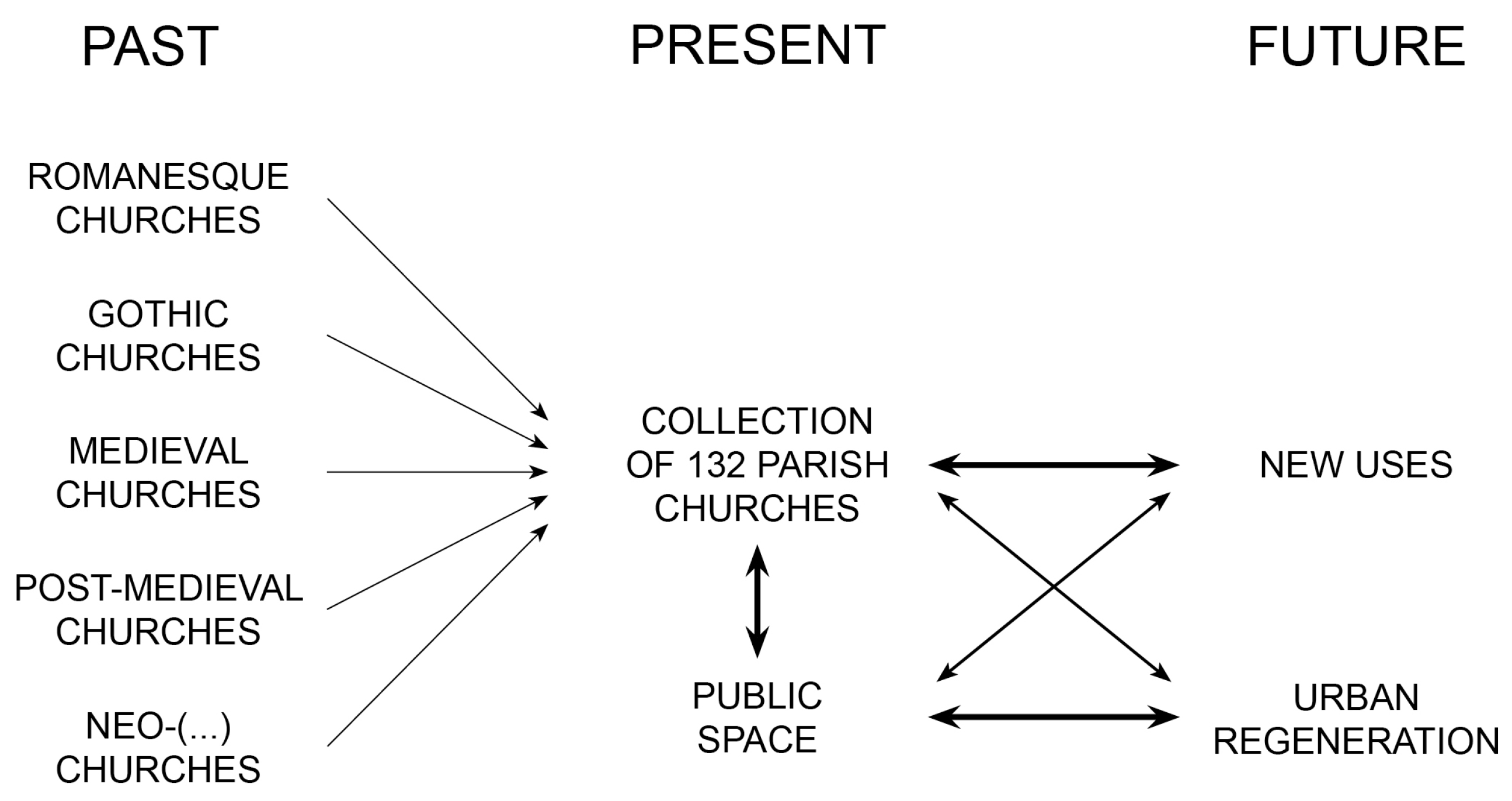
1.2. Theoretical Framework
The theoretical framework for understanding the relevance of churches in public space in Barcelona, and their relation to urban regeneration and new uses of some underutilized churches, is shown in
Figure 1.
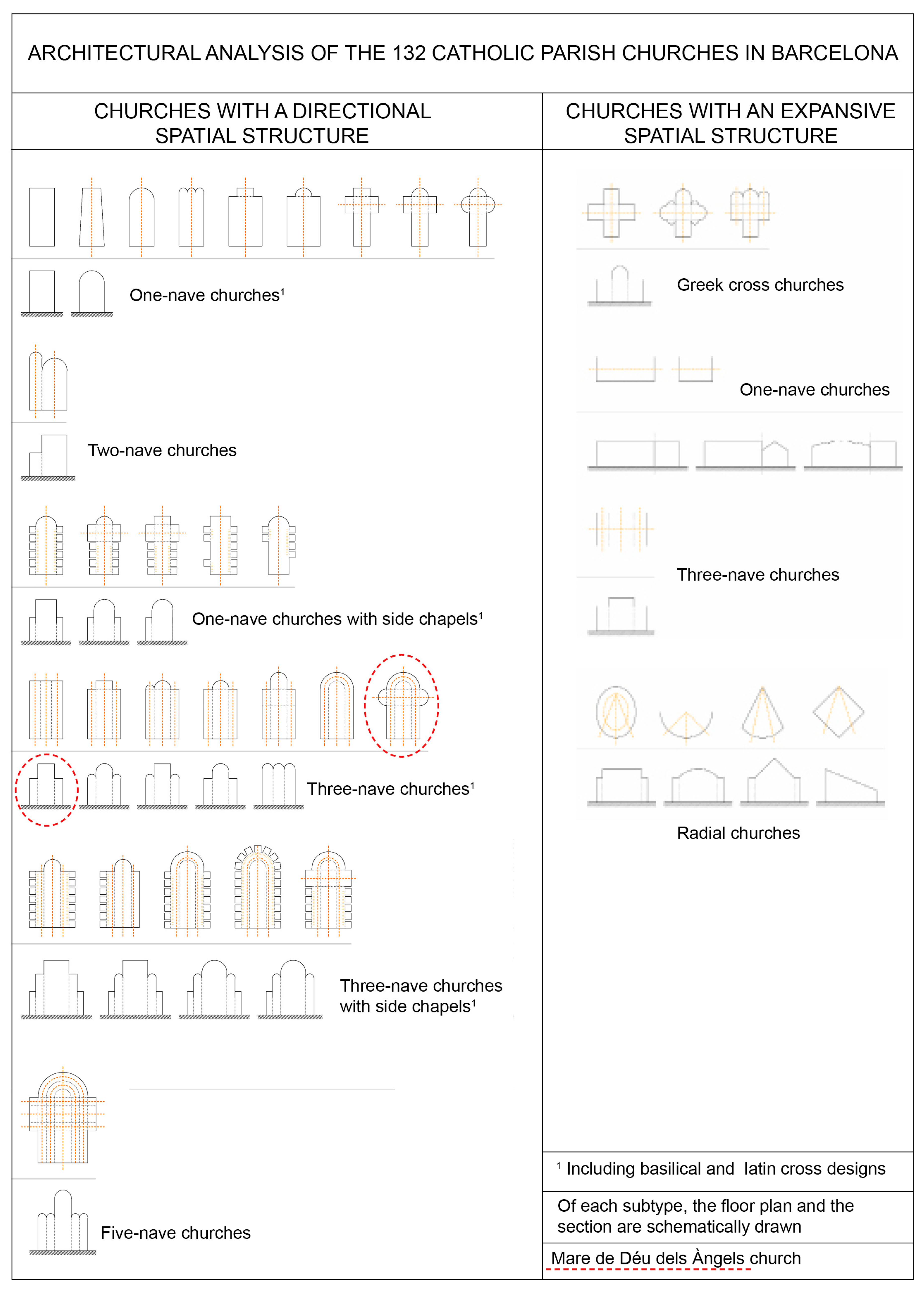
The religious buildings included in our study, that is, the Catholic churches that have the category of parish, present very varied forms and styles. Perhaps it is the singular type of building that presents the most variation, as buildings constructed in very different periods where different liturgies also coexisted. In any case, as far as the architectural spatial structure is concerned and speaking broadly, we have pre-conciliar churches and post-conciliar churches. The former, mostly of basilica type, tend towards more longitudinal and linear dispositions, while the latter, following the guidelines dictated by the Second Vatican Council (1965), promote more sprawling and radial forms for a more democratic interior space as the parish priest faces the faithful (until then, he was positioned with his back to them) and seeks interaction among attendees.
So far, we have adequate knowledge regarding the architectural, liturgical, and ecclesial aspects related to some of the churches in the city of Barcelona (such as the Sagrada Família or Santa Maria del Mar, among others, or some churches from historical styles such as Romanesque or Gothic). However, there is no adequate knowledge of the role played by parish churches, studying all 132 of them, one by one, understanding them as a collection of architectural objects. Additionally, even the most paradigmatic churches were not studied with an urban approach. Therefore, this model shows how an urban approach could be a relevant layer to add to the study of the urban growth of Barcelona. With this approach, we could establish a relationship between the past, present, and future, focusing our attention on the latter. Studying parish churches, public space, new uses, and urban regeneration could be an interesting approach to show the relevance of churches and public space in Barcelona.
It would be interesting to clarify that the 132 sacred buildings here analyzed have the category of parish churches, but not all of them were originally built as such. Some of these churches were, in the past, part of convent and monastic complexes. The ecclesiastical confiscations of Mendizábal during the 19th century caused many church assets to become property of the Spanish state. Thus, the conventual and monastic dependencies were used for other purposes (or demolished to build new buildings on the land they occupied) and the churches became the new parishes of that part of the city.
This model does not seek to explain all the complexities associated with public space and urban growth related to churches, such as social or faithful approaches. However, the model seeks to explain all the morphological possibilities between a church and its surrounding urban space.
2. Material and Methods
The present study was designed to gather information on the interrelationships established by Catholic parish churches and the public space and the urban growth and expansion of the city of Barcelona in Catalonia, Spain. All 132 Catholic parish churches located within the municipal limits of the city were included with the primary objective of highlighting and providing a deep insight of the role of religious buildings in the urban landscape and development of the contemporary city. A secondary objective was to assess potential new non-liturgical uses for some underutilized religious buildings. The following hypotheses were established: (a) there is a strong relationship between Catholic parish churches, not only of medieval churches, but also of those built recently in the XX and XXI centuries, and the urban growth; and (b) the relationships between churches and the public space is different according to the presence or absence of an open space surrounding the religious building.
The present study was based on a previous preliminary research study (doctoral thesis of Alba Arboix-Alió) of the 132 Catholic parish churches built in the course of 2000 years within Barcelona’s municipal boundaries [
20]. The data provided aim to demonstrate the existence of a possible link between church and city from the first foundational temples to the churches built in the most recently created tower block neighborhoods.
Consequently, the list here presented includes the first historical churches in Barcelona, as well as those that disappeared or were replaced by new squares or repurposed for other activities. Our goal was to include all the parish churches and use maps and drawings to connect them intentionally, highlighting the urban axes, patterns, and activities that surround the churches. We also sought to describe the evolution of Barcelona’s urban form and history.
We will illustrate this with a mosaic of representative cases plus a final representative case study: Mare de Déu dels Àngels church, where the liturgical orientation of the church and its urban adaptation to Cerdà’s plan were successfully combined and is useful to discuss the eventual reuse of public space.
In methodological terms, we made a complete list of the 132 existing parishes within the municipal limits of the city, and we also elaborated a collection of files—one for each church—where we systematically analyzed the architectural objects presented from the planimetry and urban situation along the historical information of its past and present.
All this information was collected through active in situ visits in all the parish churches of the study (drawing and taking current photographs of all of them) and from various archives of the city of Barcelona (searching and comparing old photographs and maps), forming the scientific and unpublished corpus of the research.
The authors consulted and analyzed the following archives and catalogs: Diocesan Archive of the Archdiocese of Barcelona; Barcelona Municipal Archives; Historical Archive of Barcelona; Archive of Provincial Council of Barcelona, Historical Archive of the Association of Architects of Catalonia, Photo Archive of Barcelona, Archive of the Excursionist Center of Catalonia, Archive of the Gaudi Chair, Archive of the Cartographic Institute of Catalonia, Archive of the National Art Museum of Catalonia, Archive of the Museum History of Barcelona, and several parish archives and the inventory of Churches of JM Gavín.
The AutoCad computer software was used to create precise drawings of the 132 Catholic parish churches based on the notes and sketches taken by hand during personal on-site visits and the plans collected from the different sources (archives and catalogs), following the graphic style of Camillo Sitte and Nolli. All the current plans are self-made. The different quadrants of the cartographic records of the City Council (
https://w20.bcn.cat/cartobcn/, accessed on 30 April 2023) were downloaded, piece by piece, and joined through the AutoCad program. The layers of interest were selected, line thickness and colors were edited, patterns were added, and churches and their surrounding urban spaces were drawn on top. For the Nolli’s style, the Photoshop program was used, so that the churches and urban plans were then superimposed.
The historical evolution of the appearance of these 132 parish churches in the city of Barcelona was also analyzed. It should be noted that the location and placement of buildings are crucial to the urban growth of a city. While we may see modern or contemporary structures today, many of them are actually the second, third, or even fourth iteration of a church built on the same plot, with the original structure dating back centuries. Over time, forced expropriations by the ecclesiastical government and wars led to the rebuilding of these sacred spaces. However, for the purposes of our analysis, we approached the city’s history from a present-day perspective (taking inspiration from Italo Calvino’s approach). When gathering data to draw our pictures, we considered the year of the current building while also keeping in mind the year of the first structure on the site.
The methodological approach used, then, was both deductive and inductive, guaranteeing its applicability beyond the city of Barcelona itself.
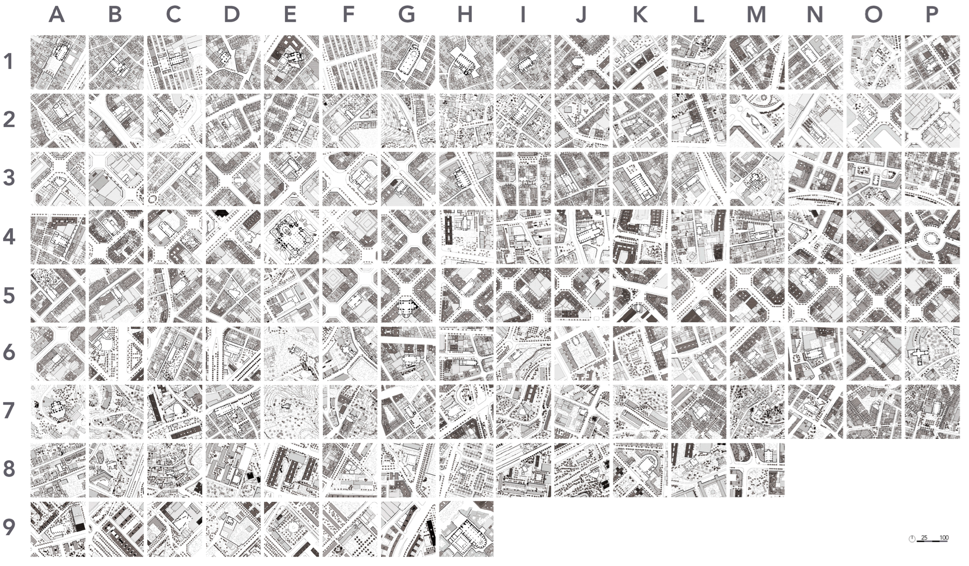
As a result, an urban layout of the parish churches in the city of Barcelona was carried out with the sacred interior open to the surrounding public space to visualize the relationship between the church and urban space. They were drawn in the style of Nolli’s plan (
Figure 2). Additionally, these 132 urban enclaves were drown following the Camillo Sitte’s style.
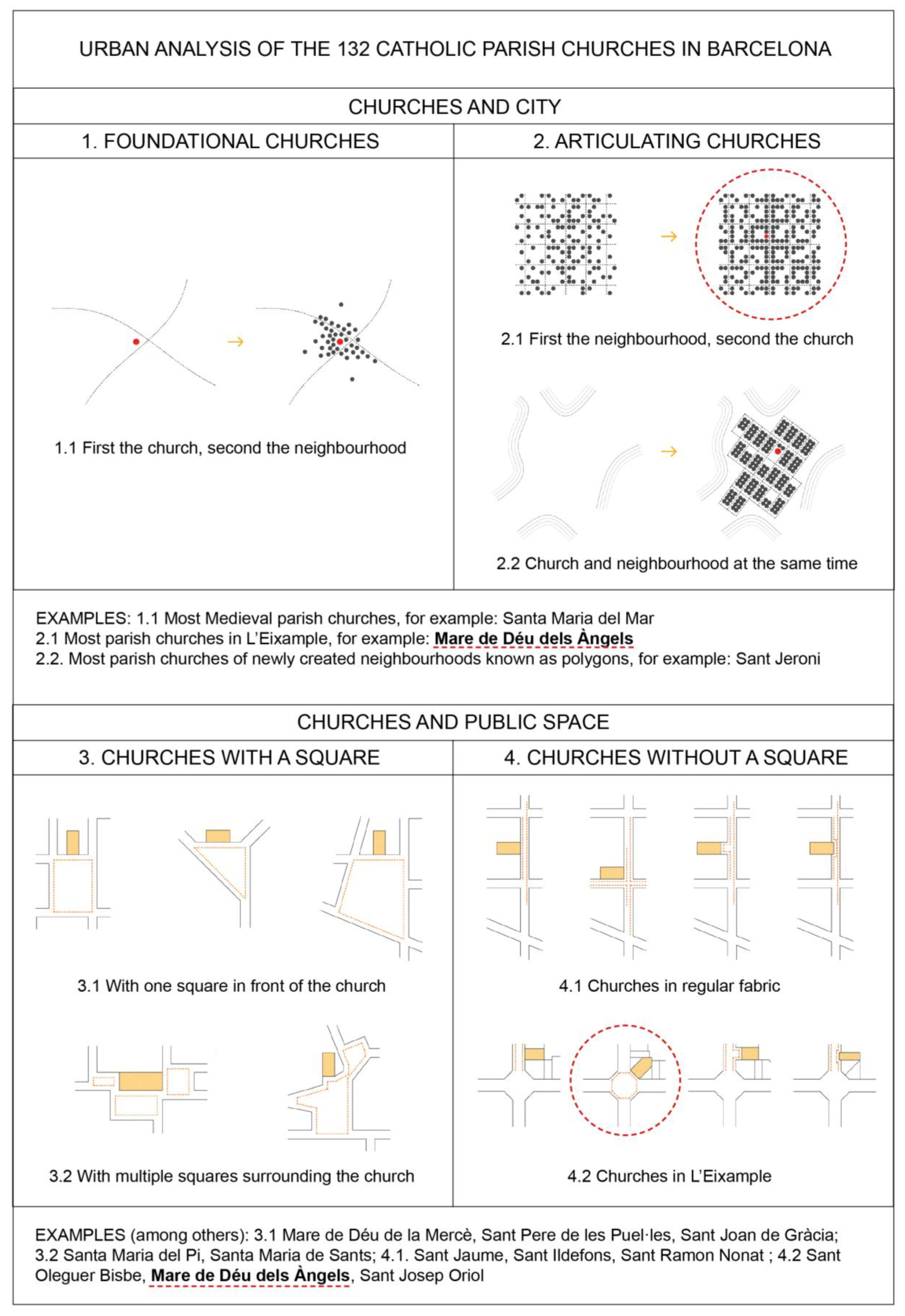
Consequently, we classified the relationship between parish churches and urban space in the city of Barcelona using the following approaches: (1) foundational churches; (2) articulating churches; (3) churches with a square; (4) churches without a square, including a subsection for “shoehorned churches”; (5) Mare de Déu dels Àngels church, which is presented as a case study, and (6) urban regeneration.
This was a didactic classification acknowledging that each church can belong to more than one of these approaches. For example, one church can have a square and also be considered foundational, or it may not have a square and still be an articulating church, as was the case with Mare de Déu dels Àngels church.
3. Results
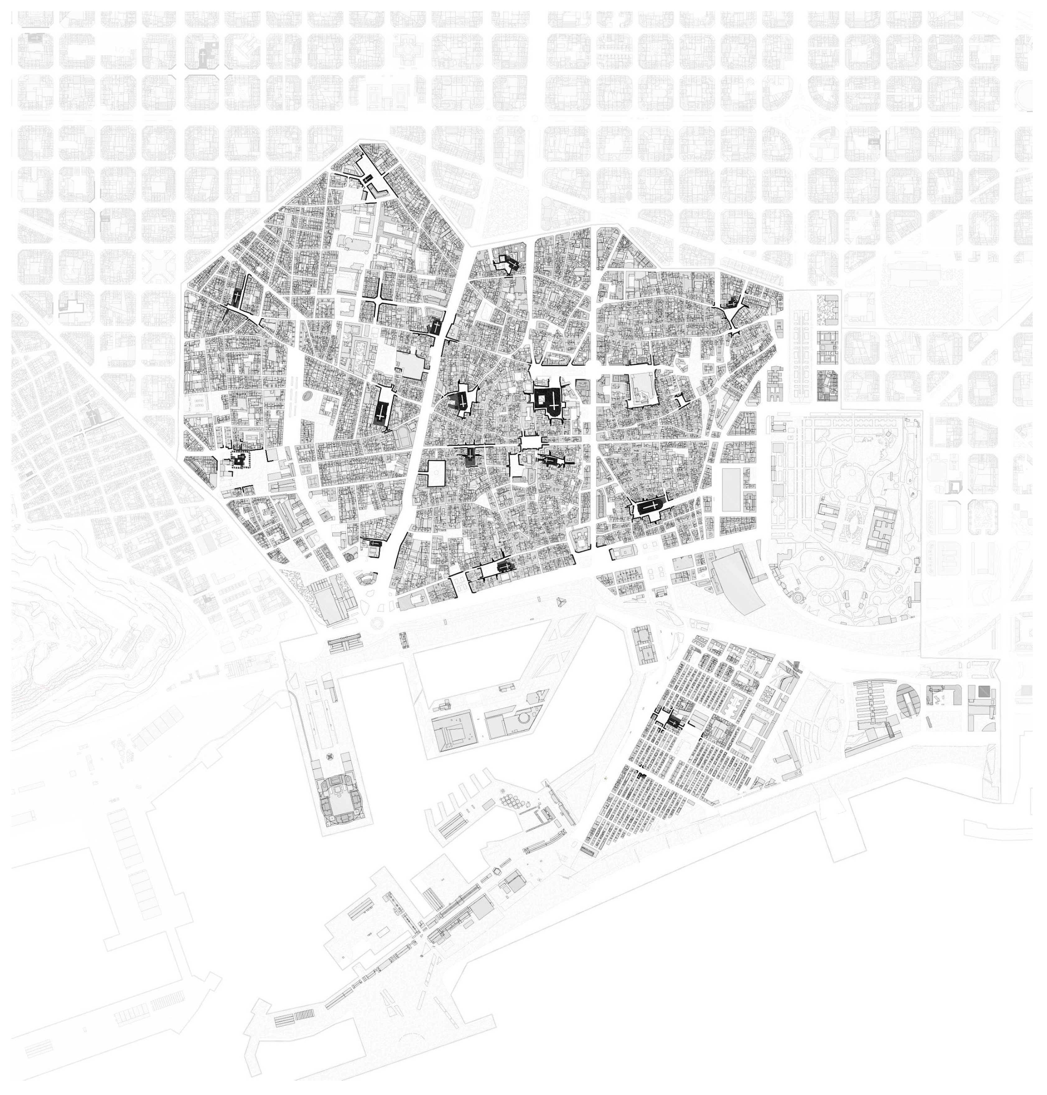
The results of the research, presented in maps and drawings (overview in
Figure 3 and
Figure 4), are organized to understand the different urban relationships that exist between the churches and the city, from urban, architectural, and social points of view, starting from the oldest churches to the newest ones.
3.1. Foundational Churches
In the early days of the Roman city of Barcelona on Mount Taber in the first century BC, as well as throughout the medieval period, the foundational role of ecclesiastic buildings in the formation and growth of this city was very revealing. If we look at the attached figure, a mid-19th century city map showing the churches that currently have parish status, their importance within the urban form as it is today becomes easily understandable (
Figure 5). In this way, by analyzing the location of the churches in relation to the roads leading out of the medieval city, we can observe how they gave rise to new urban settlements around them, representing the beginnings of the urban expansion of Barcelona.
In the inner ring surrounding the Roman city, suburbs emerged in the environs of the parishes of Santa Maria del Mar, Santa Maria del Pi, Sant Pere de les Puel·les, and Santa Anna.
While these population centers—closer to Roman Barcelona—were already consolidated by the 12th century, from the 13th century onwards, the agricultural centers surrounding slightly more distant churches became stronger and grew in size and the number of inhabitants: Sant Vicenç de Sarrià, Sant Joan d’Horta, Santa Maria de Sants, Sant Andreu del Palomar, Sant Martí de Provençals or Sants Gervasi i Protasi, the latter popularly known as ‘La Bonanova’—that is, the Good Tidings, the Good News—all bearing a dedication that would later be used to christen the respective neighborhoods centered around them.
In the centuries that followed, new settlements continued to consolidate, also with a church as their main feature. These are other examples that appeared on the same map: Verge de Gràcia i Sant Josep—or, to use its popular name again: ‘els Josepets de Gràcia’—Santa Maria de Gràcia in the same district, Sant Miquel del Port in the Barceloneta neighborhood, Santa Maria del Remei in Les Corts, Sant Àngel Custodi in Hostafrancs, Santa Maria del Taulat in Poblenou, and Sant Martí del Clot in the ward of the same name.
Consequently, a linear and direct “cause–effect” relationship between the foundational church and the growth of the urban space was observed.
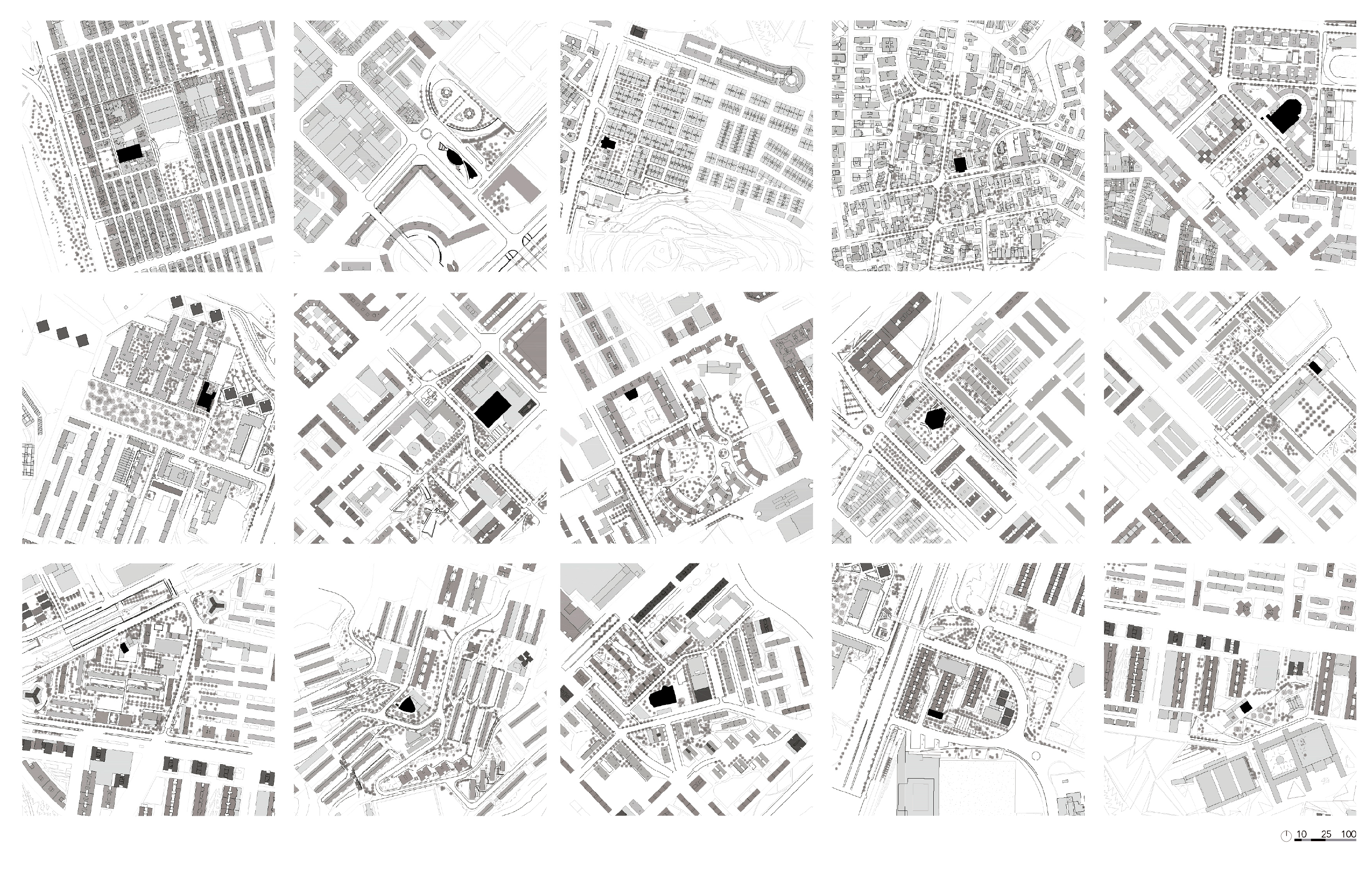
3.2. Articulating Churches
The relationship between ward and church can be much more complex than the linear case of the foundational city [
20]. On the heels of the well-known expansion of the city undertaken with Cerdà’s homogeneous plan, Barcelona went through a great demographic and urban boom in the mid-20th century. The first wave of immigration in the 1920s and two other waves of even bigger intensity throughout the 1940s/50s and 1950s/60s [
9] would render the medieval growth model obsolete: as a response, the regular layout of the Eixample district was filled in, neighborhoods suddenly sprouted around a factory or a commercial axis, and industrial estates would be projected on paper and transposed into the city at the same time, three of the new ways of operating [
22] (
Figure 6).
Before that, Barcelona began to gain international prominence with the two Universal Exhibitions held there, the first in 1888 and the second in 1929 [
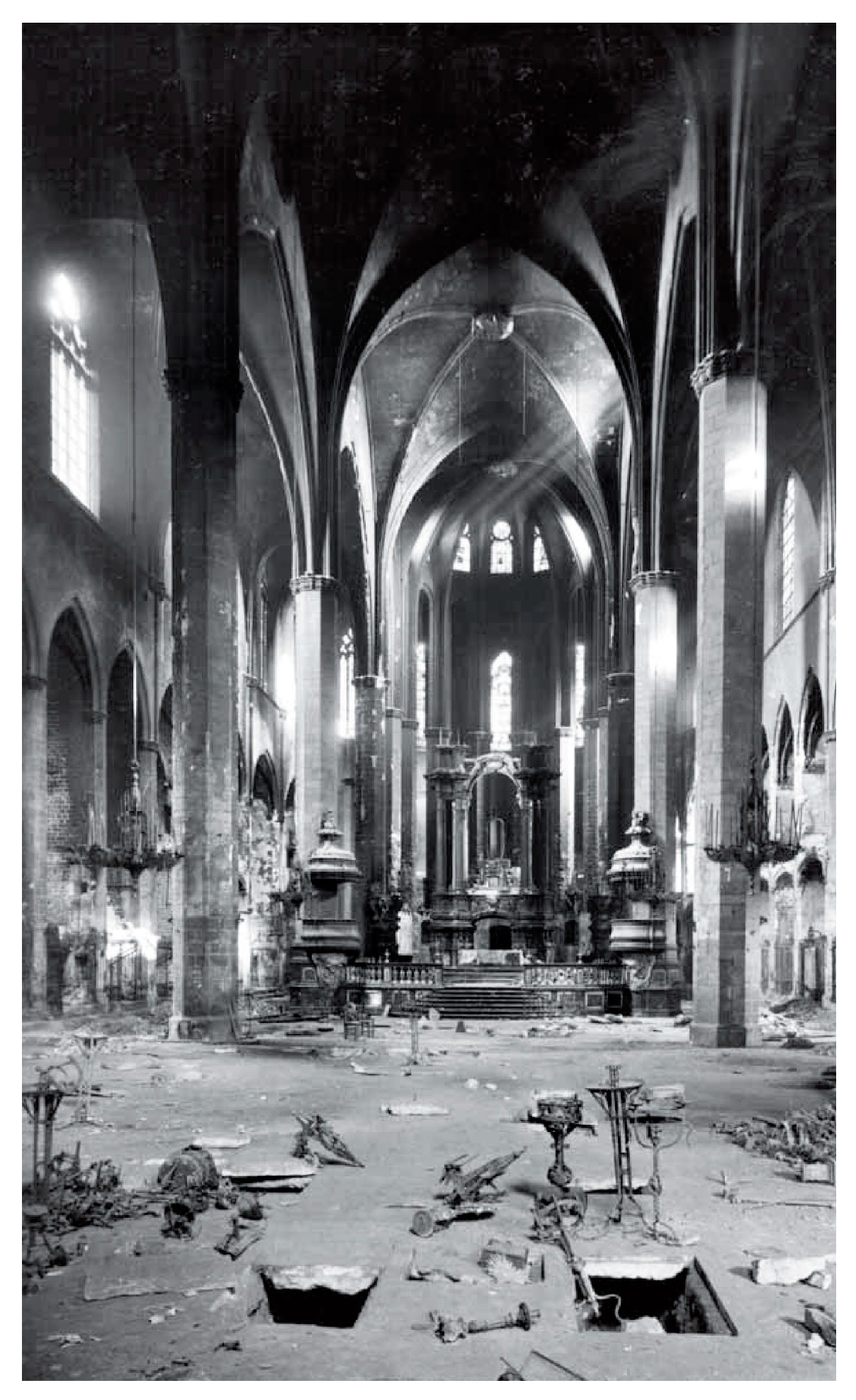
23]. The Spanish Civil War (1936–1939) partly slowed down that expansion, as did the Second World War (1939–1945), which had an impact on Spain, even though it did not take part in the conflict. The period after the wars was a time of destitution. A practically destroyed country had to be rebuilt, aggravated by the shortage of raw materials [
24]. The resulting constructions were affected by the use of very poor materials. Churches were once again the protagonist buildings in two ways. On the one hand, they were particularly damaged during the war; and on the other hand, resources for their proper reconstruction were not available (
Figure 7).
It was not until the 1960s that the country experienced significant economic growth again. That translated into a significant level of development in turn [
25]. Cities grew rapidly, a fact that necessitated the creation of new housing and social infrastructures, with churches being normally either the only buildings of this type to be built or the first to be constructed.
Once again, the internationalization of the city became fully apparent during the closing decades of the twentieth century, in an increasingly globalized context. An event that undoubtedly came to define it was the designation of the city as the venue for the XXV Olympic Games of 1992. In the 21st century, we can highlight Barcelona’s hosting of the Forum of Cultures in 2004.
In hindsight, it was revealed that the churches also played a leading role in consolidating those newly created neighborhoods. Both in those quarters that emerged prior to the construction of a particular church and in built-up areas that were planned with a church in mind, it can be shown that, in most cases, the local church is the only public building that articulates an eminently residential complex. It is the architectural piece associated with the emergence of a free space in the area—often, the defining feature of the only square in the settlement. It is the landmark placed at the spot of a greatest visibility, it is the one building that usually stands out from the alignment and urban homogeneity of the complex, and it is the symbolic element that defines the specificity of an urban enclave. Additionally, all this, not least because churches are “singular buildings” [
26] but, and perhaps even more crucially, because they are accompanied by a singular urban feature: the square [
27]. Aldo Rossi is cited here to effectively point out that churches are singular buildings that stand out among the common fabric of the city. These buildings can be included in the triple classification of “monument”, “physical sign of the past”, and “plan drawing”; thus, in the words of the Italian architect, they are primary elements that are active elements of urban form, understood as monuments that are preserved and represented as propulsive facts of the evolution of the city.
Accordingly, we can find examples in a number of neighborhoods, ranging from La Barceloneta (1753, the first industrial estate in Barcelona, that is, the first quarter that was first planned on paper and then transferred to the city) to La Vila Olímpica (1992, the last large neighborhood built in Barcelona following this urban logic, in the context of the previously mentioned Olympic Games held in the city); ‘Las Casas Baratas’ groups of the 1920s, and the industrial estates of the outskirts built in the 1950s and 1960s. Certainly, focusing on the sacred architectural work, the range of examples appeared to be broad and varied (
Figure 8).
However, there was no architecture without urban planning, nor was there urban planning without history—understood in the broadest sense of the term. We can speak of the city, on the one hand, of the architectural project, on the other, and about the events that took place in a third instance, but admitting that the relationship between these three parameters was above them. Thus, Barcelona, like so many other international cities, such as Paris, London, or Amsterdam, is not only composed of its individual buildings, nor is it only designed on the basis of its urban plans. Likewise, no sense can be made of it merely through the historical events that have taken place there. The city of Barcelona is projected, developed, and explained through the formal articulation of its various parts over time and in concordance with economic, political, social, and cultural developments.
In this way, the multiple and diverse objectifiable forms of Barcelona’s urban growth—a synthesis of architectural and town-planning projects, along with social, political, economic, cultural, and religious episodes—stand as direct testimonies for the understanding of a much richer and convoluted tangle. Additionally, in this intricate panorama, as the following image substantiates, the parish churches were found to play an active, clarifying, and leading role.
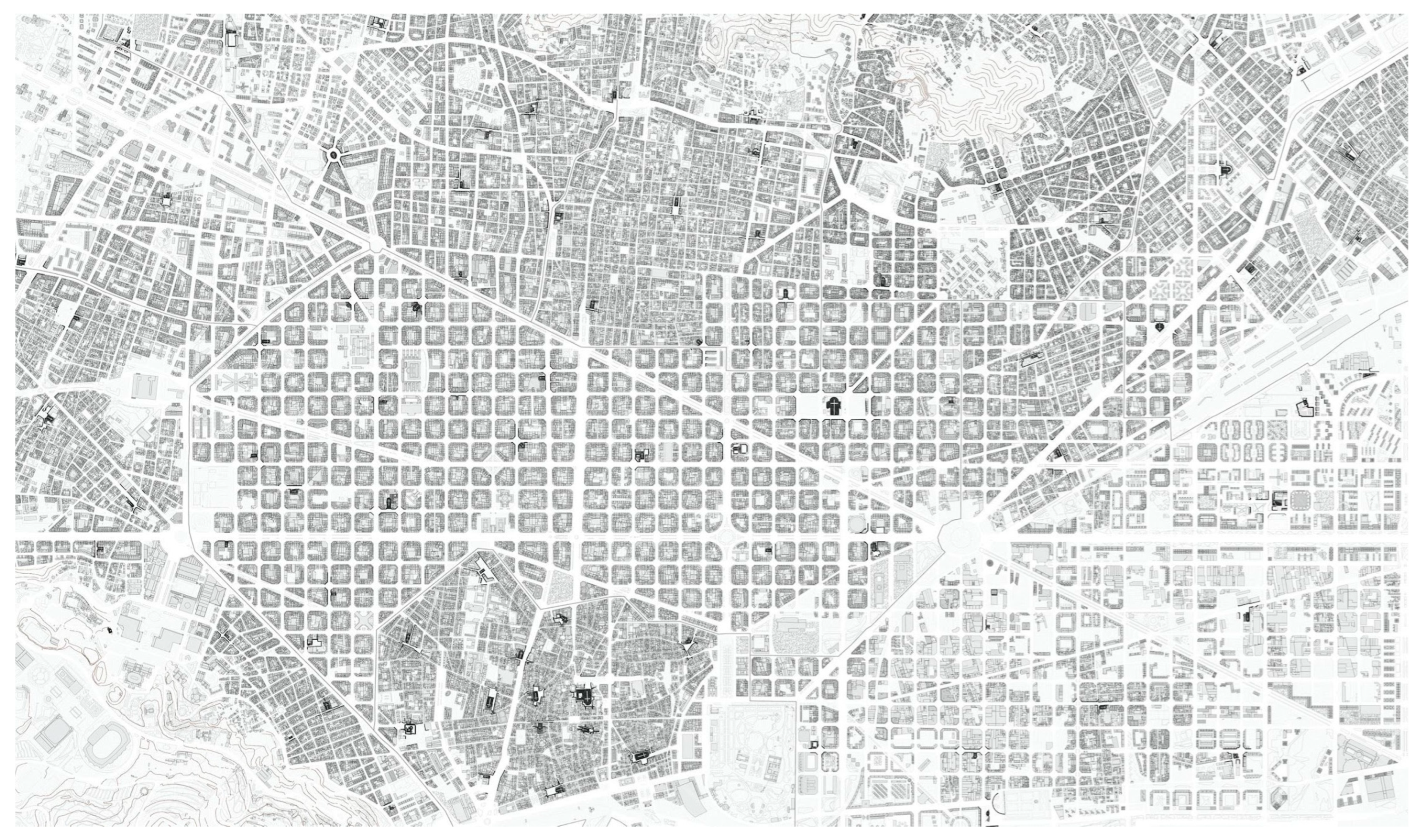
Figure 9 shows the historical evolution of the 132 parish churches located in the city of Barcelona, categorized by the year when the current building was constructed. Among these churches, 1 dates back to the 10th century, 1 to the 11th century, 2 to the 12th century, 1 to the 13th century, 4 to the 14th century, 1 to the 15th century, 10 to the 16th century, 7 to the 17th century up to 1855, 28 from 1856 to 1921, 32 from 1922 to 1956, 29 from 1957 to 1972, and 16 from 1973 to 2015.
The historical intervals refer to the following dates that represented a turning point for the urban growth of the city and the number of existing parish churches: 1856, ecclesiastical confiscation of Mendizábal when many convents, abbeys, and monastic churches became parish churches (although the government decree was released in 1836, the main transformations to which it gave rise can be considered, in the case of the city of Barcelona, from 1855 onwards); 1921, first waves of migration of people from other Spanish regions (e.g., Andalusia) as a result of which the first polygon neighborhoods (also known as “cheap houses”) were built; 1957 and during the 1960s, the strongest waves of migration took place, and all the polygon neighborhoods on the urban periphery were built, which made up the last neighborhoods that belong to the city. Starting in the 1970s, a final group was categorized to include the last parish churches built in the city of Barcelona.
The historical evolution of the 132 parish churches can provide insights into the growth and current shape of Barcelona. Through their distribution, we can observe the core of the medieval city, the independent urban settlements that are now districts of the city, the grid layout of Ildefons Cerdà, and the expansion of newer neighborhoods. The churches are dispersed throughout the city in an isotropic pattern, reflecting the city’s form. Notably, there are no sacred buildings in areas without urban settlements, such as the Port and the mountains of Tibidabo and Montjuïc.
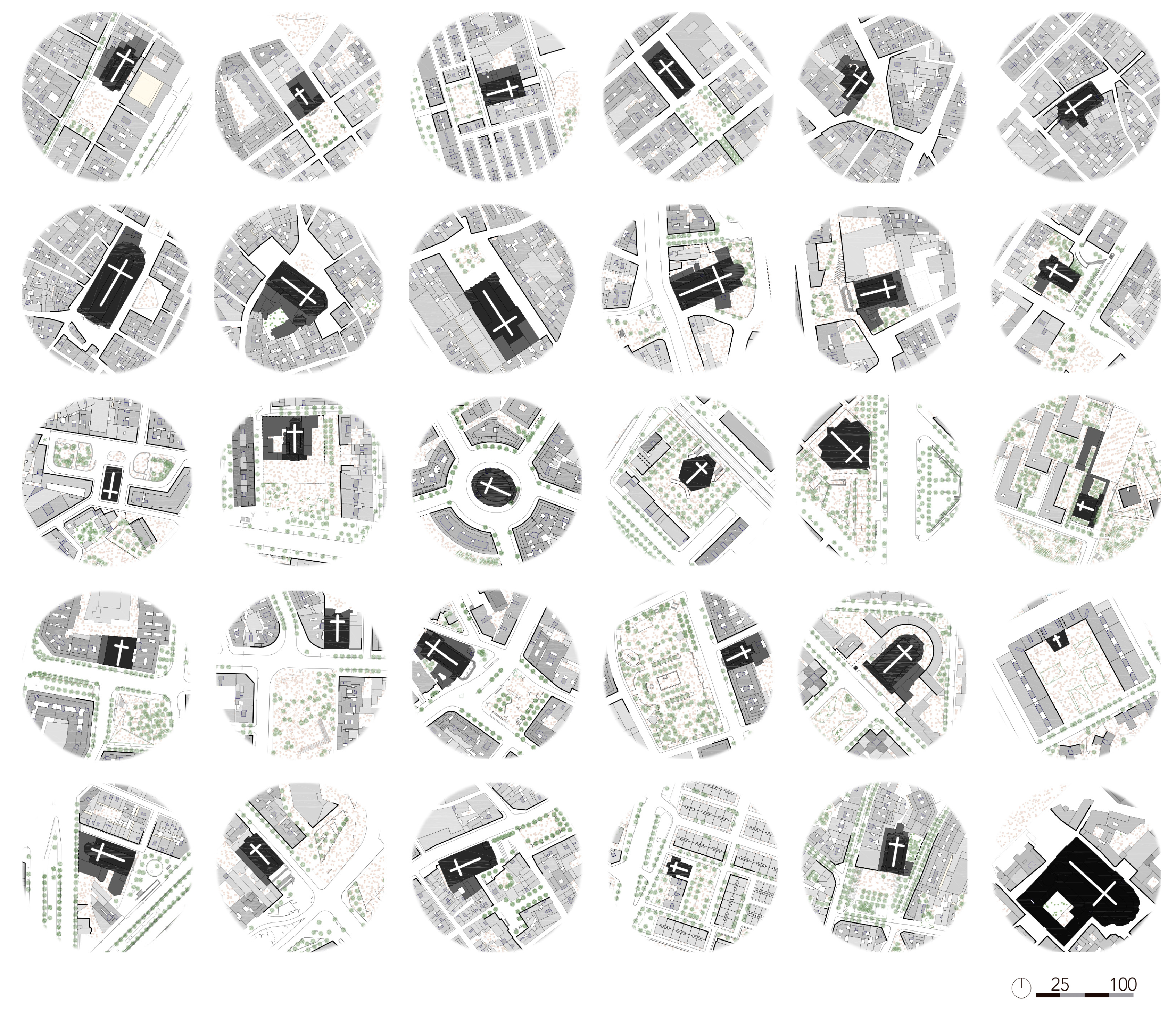
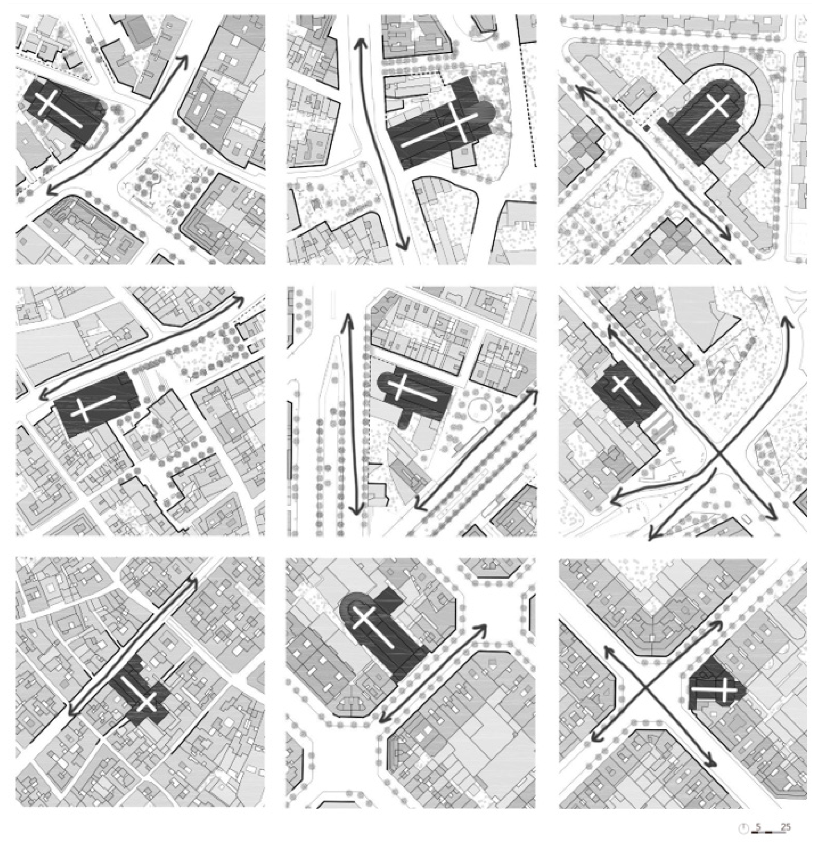
3.3. Churches with a Square
Throughout ages and styles, and in any urban fabric, this paper demonstrated that, whenever possible, a square accompanied the church. In those cases, the sacred facades, although part of the church, also acted as the square’s main decoration, both comprising an inseparable entity [
28]. It is not trivial that in so many cases, a square and a church share their name and make up a single urban image. This is true both of foundational urban enclaves and of the most recently created neighborhoods in industrial estates (
Figure 10).
This idea, focusing on empty space and the walls that delimit it, appeals directly to the origins of the Mediterranean city, the genesis of which lies in the presence of the public agora. So much so that some authors argue that in a country accustomed to pouring out into the streets to celebrate festivities, nothing but public space is required to live in a community. José Ortega y Gasset, Louis I. Kahn, and Jahn Gehl often claimed that the city needs nothing more than facades as decoration, that the street is an open-air community room, and that the city is, in fact, comprised by the social life that takes place between buildings [
29,
30,
31]. This way, the square becomes the communal space par excellence, and the buildings that delimit it, an unrivaled backdrop. In this representative scenographic support of the city, the church becomes the landmark that singles out an urban enclave and symbolizes a neighborhood (
Figure 11).
That said, obtaining empty space is a key issue not only for new churches but also for existing ones. A good example is the parish church of Mare de Déu de la Mercè i Sant Miquel Arcàngel, at the end of Las Ramblas. Initially, this church had no matching square. There was no empty space to accompany them, neither in the case of the original 13th-century Gothic building nor with the currently standing Baroque one, built in the 18th century on the same spot. In 1982, however, in an act of urban microsurgery, the block in front of its main facade was demolished, offering the church and the whole area more light, salubrity, perspective, and urban usability.
There are some other instances where the appearance of urban gaps originated from ecclesiastical expropriations. During the Liberal Triennium (1820–1823), one of the oldest parishes in the city, Sant Jaume, was demolished, giving the Town Hall Square its current shape. Later on, due to Mendizábal’s Confiscations in 1836, a large number of orchards and cloisters were replaced by streets and public squares. The transformations of the site of the Trinitarian Fathers must be highlighted. They gave rise to the present-day Liceu theatre, as well as those of the convents of Sant Josep and the Discalced Carmelites, which became the location of the current Boqueria market [
23]. However, if anyone’s space was taken away to be publicly offered to the city, it was that of the deceased who used to rest in the parish cemeteries. During the second half of the 18th century, there was a strong demographic expansion in Barcelona while the town was still confined by its walls. Additionally, industries were growing and vying for land. The only available empty spaces left—although they were private and secluded—were the churchyards. The Floridablanca Law was passed in this context. It was a government order enforcing the transfer of all cemeteries adjacent to the parishes outside the city walls. Thus, former churchyards became the new parish squares of Santa Maria del Pi, Santa Maria del Mar, Sants Just i Pastor, and Sant Pere de les Puel·les, among others.
Thus, Barcelona gained urban space thanks to its parishes. It was the churches that, with this strategic operation, offered specific spots in the city that could be “sponged”, shaping the system of concatenated medium-size and small squares that we find in the old fabric of modern Barcelona (
Figure 12).
In any case, from the moment empty spaces begin to appear around the temples, they become endowed with greater versatility and functionality. Using the city as a stage, without the need to build new infrastructures, is a much cheaper way to celebrate festivities in a country where, owing to its climate and culture, streets and squares are already “the great theatre of the world”. They are the place for funerals, weddings, and baptisms; the place for processions and public blessings; the place for popular celebrations and, in short, the setting for all kinds of feasts.
3.4. Churches without a Square
Unfortunately, many streets and squares adjacent to churches are only used for circulation and not for staying. They are increasingly used as infrastructures for passing through rather than as an open-air hall where socializing and liturgical functions can be carried out. There are cases—some of them conceived as such right from the design stage—where the church and the square are separated by the passage of a road.
The presence of a cut between the large, empty space and the church gate—the visual discontinuity and the physical separation of the ground floor—undermines the dialogue and spatial continuity that should exist between the “roofed square” represented by the church and the “open-air room” that the square represents. This segregation between the church and the adjacent space became more pronounced with the arrival of the motorcar and, above all, with the specialization of streets, since, in most cases, the crossings were already in place, but the entire public space became uniformly paved or covered with sand, so carts, bicycles, and pedestrians could pass through it.
Some architects such as Camillo Sitte and Aldo van Eyck praised the conditions squares exhibit when they are covered in snow. That is precisely because the snow causes the unevenness and zoning of the area to vanish, promoting the freedom of movement and use alternation naturally allowed by the old medieval squares [
32,
33].
Some spaces appended to churches—far from being understood as areas which lack divisions—now are full of irregularities, distinctions in paving, zoning for specific activities, and many eventually end up filled with fences and perimeter walls (
Figure 13).
A Shoe-Horned Churches
However, a church located between medians—a special church without a square—that only shows its main facade to the city, and cannot easily obtain an empty space to configure its entrance atrium (a “shoe-horned church”), is the type par excellence among those inserted into the mesh of the Eixample (
Figure 14). This is typical of all churches built within regular grids of any city. However, Ildefons Cerdà, in his “Teoría General de la Urbanización: Reforma y Ensanche de Barcelona”, referred to the street not only as a place of passage, but also as a public space, a place of relationship and coexistence, and an auxiliary atrium for the houses [
21]. Its multifaceted character can be seen in the great infrastructure he proposed: a binomial of circulating and permanence, which, therefore, distinguished ‘road’ from ‘street’ and, therefore, emphasized their non-synonymous nature. Cerdà emphasized the complexity of the latter (street), which encompassed the former (road) by including the buildings that limit and contain it, and above all, make up a courtyard for dwellings. In what became the first modern treatise on town planning, he wrote: “The street must be considered by every practitioner in charge of studying the project of reform, enlargement or foundation of a city under the double concept of the courtyard or courtyard-of-the-house, and the public thoroughfare” [
21].
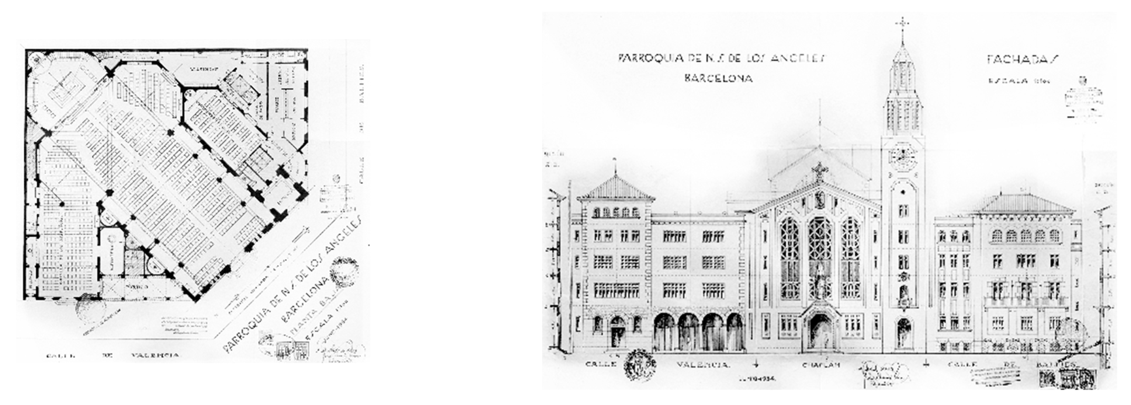
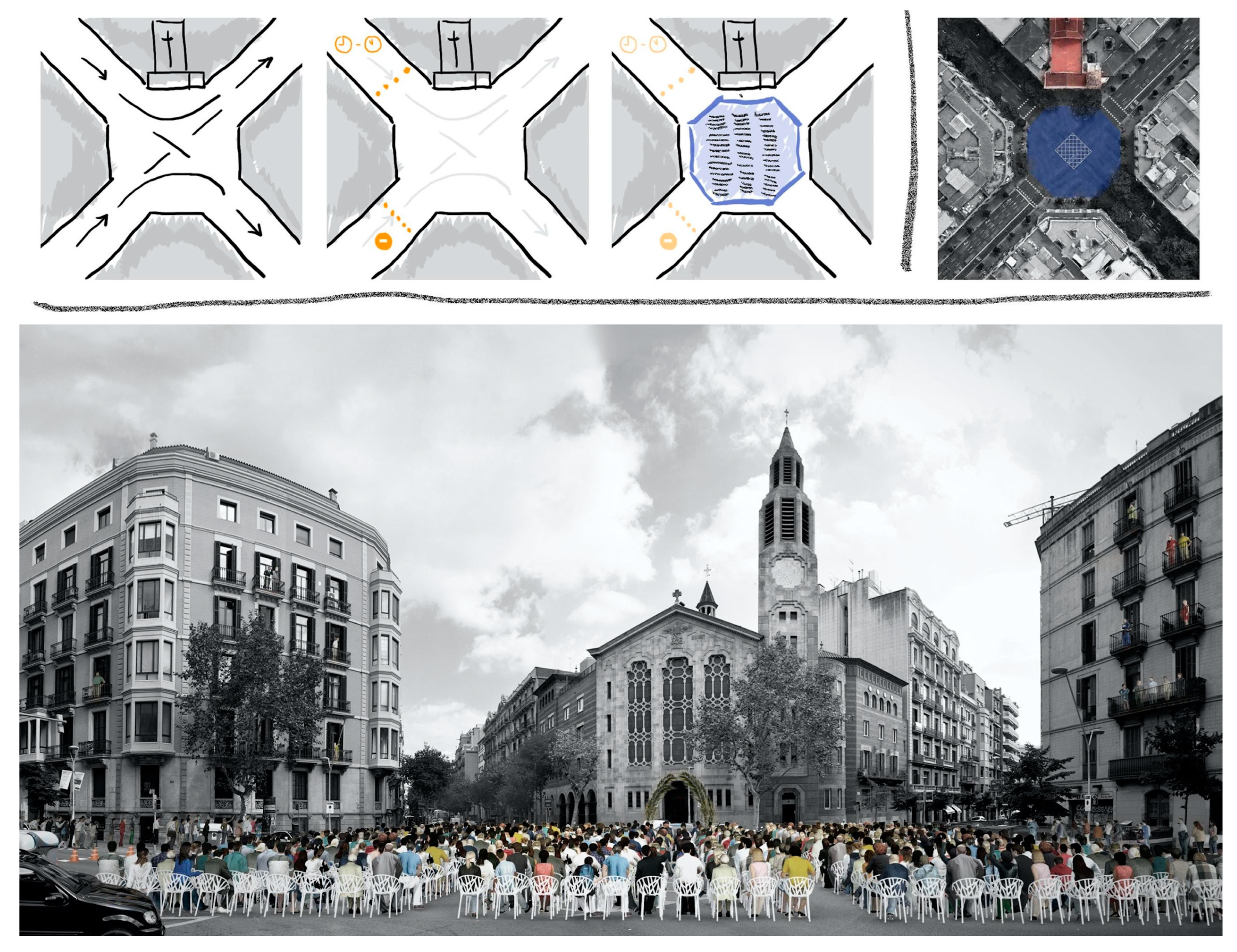
3.5. Mare de Déu dels Àngels Church as a Case Study
A paradigmatic example of a shoehorned church into the Eixample district, one that has no apparent free space around it, is the parish church of Mare de Déu dels Àngels, at the intersection of Balmes street and València street. At this time, this church is a significant example of the potential urban regeneration (
Figure 15).
Josep Danés i Torras, one of the leading exponents of Catalan regionalist architecture and a member of the second generation of Noucentist architects, was the architect of Mare de Déu dels Àngels church. The canonical erection of the parish dates back to 1868, but it would not be until more than half a century later, specifically in 1932, during the Second Spanish Republic (1931–1939), that the parish boundaries were defined, and this site was allocated for the church.
Therefore, this parish, although built after the war, is considered a Republican era project [
34]. However, above all, the Mare de Déu dels Àngels parish church has the virtue of being excellently implanted in the urban fabric of Barcelona’s Eixample. Josep Danés rejected the increasingly recurrent idea of leaving the religious building fully isolated. As early as 1889, Camillo Sitte warned that, contrary to what seemed to be becoming fashionable, religious architecture should always be well attached and strongly embedded in neighboring buildings [
32]. According to the Austrian architect, an expert in the principles that make cities beautiful, isolation only brings drawbacks to a church: the sacred building’s interest can be distorted, the architect needs to devise four monumental facades instead of just one—with the entailing cost increase for those paying for it—the empty space where it is located is narrow, the perspectives are shortened and, likewise, some free directions of circulation around it are lost.
Mare de Déu dels Àngels church is undoubtedly the paradigm of sacred architecture in L’ Eixample district. Not only because it is a magnificent lesson in adaptation to the orthogonal and homogeneous urban landscape of this neighborhood, but also because it is elegantly placed on the corner, the genesis of its layout. This church is the ecclesiastical model of Barcelona’s Eixample because it is the only parish church in the whole fabric that perfectly combines the correct urban implantation with the exact theological orientation to which the Christian religion aspires [
20].
In fact, at each crossroad of the Barcelona grid, one of the four facades is perfectly arranged along the west–east axis (access-apse), providing the correct orientation of the church according to the liturgy. Each east-facing chamfer of each street crossing of L’ Eixample district allows the optimal placement of the sacred piece without interfering with the shape of the layout or in compliance with the approved urban planning regulations.
There are other parishes located on chamfers, but without choosing the one that prioritizes Christian orientation: Sant Eugeni i Papa (1880, Jeroni Granell), Mare de Déu del Pilar (1939, Antoni Fisas, of which only the crypt was ever built), and Sant Francesc de Pàola (2005–2009, Guillermo Maluenda Colomer and Tomàs Ivars Companys) are positioned on a north–south axis (access-apse), and Corpus Christi (1963–1965, Jordi Vidal de Llobatera) faces the less favorable direction, that is, accessing from the east and advancing towards the west.
All the parish churches belonging to existing archpriestships in the fabric of L’ Eixample could have been correctly orientated if they had been located at the eastern corners of the respective crossroads instead. However, there is only one, that of Mare de Déu dels Àngels, which, consciously or unconsciously, realized this and took advantage of it.
3.6. Urban Regeneration
Considering Ildefons Cerdà’s definition of his urban plan once again, even though, nowadays, a plan that is appealing to car traffic has more weight, we have examples in Cerdà that show that this road infrastructure is possible to tame. Weekly markets or street markets, occasional open-air shows, and specific celebratory events bring cars to an exceptional halt and force a change in the appearance and use of streets and squares by putting them at the service of traders and pedestrians for a few hours.
Thus, applying the idea of the reversibility of functions for the public space that is part of the sacred heritage, we present a proposal to occupy the street on a one-off basis. All that is needed is a few folding chairs, some light and reversible elements, and well-managed occupation time. The temples that would benefit the most from such a proposal are those that do not have squares in front of them, such as those in the Eixample, especially churches which occupy the chamfers, as the crossroads offer a clean and smooth canvas with the potential to celebrate multiple miscellaneous celebrations. Moreover, it was argued that they are the only ones that offer the possibility of correctly orienting the church along an east–west axis, as dictated by the Christian liturgy.
Therefore, in front of Mare de Déu dels Àngels church, the only parish church in the whole of the Eixample which displays this orientation, and which has crossroads in front where any given celebration can be held. A colored square could be painted on the asphalt to highlight the status of ‘street’ and square and to celebrate, on a specific day, a blessing of palms or an open-air wedding. In short, it is proposed to recover the alternation of uses inherent to Cerdà’s urban layout, demonstrating that the crossroads between Balmes and València streets can become, for a few hours, the square that accompanies the church (
Figure 16).
In short, future perspectives between churches and public space could adapt the street and bring the religious use outside the temple when it does not have sufficient capacity to host a specific activity. This is a strategic element that can be useful in some churches.
Another future perspective could be replacing activities in churches that were left with less liturgical use or carrying out an alternation of liturgical and non-liturgical functions in the temple itself. A library, archive, museum of liturgical art, or exhibition hall are some examples of potential new uses that some churches could have. Examples of churches with new and complementary uses in Barcelona include: La Central del Raval bookstore inside Capella de la Casa de la Misericòridia, the MACBA Museum inside Capella del Convent dels Àngels, the MareNostrum Supercomputer inside Capella Manel Girona, Pere Pruna Civic Centre inside Convent de les Mares Reparadores, Exhibition Space inside the ancient chapel of Hospital de la Santa Creu, and the MUHBA Museum inside Capella de Santa Àgata.
Finally, from the level of cultural recognition, 45 churches (34%) have the distinction of assets of cultural interest by the city council (n = 37) or national heritage (n = 8). Additionally, cartography of the ecclesiastical jurisdictions is not included in the study but more information can be obtained from the Diocesan Historical Archive of the city of Barcelona at
https://esglesia.barcelona/es/delegacions/arxiu-diocesa-de-barcelona/, accessed on 30 April 2023. Additionally, at
https://esglesia.barcelona/mapa/?lang=es, accessed on 30 April 2023 there is an online map with this information [
35,
36,
37].
4. Discussion
This investigation evidenced that Catholic parish churches influenced both the public space adjacent to the religious temples and the urban growth and expansion of the city of Barcelona, as shown in
Figure 3. This occurred in all churches from historical ones to the most recent buildings.
We would like to emphasize that the present study was based exclusively on Catholic parish churches within the municipal limits of the city of Barcelona. Temples of other religions were not the purpose of the study and were not analyzed. All Catholic parish churches (n = 132) independently of the architectural design were included in our study (as shown in
Figure 3 and
Figure 4), confirming that the classification proposed for the urban and architectural analysis of these churches allowed to approach the study objectives and corroborate the hypotheses.
A linear direct “cause–effect” relationship between the foundational church and urban space was observed. In all of foundational churches, the foundation stone of urban settlements was precisely the church, which was accompanied, in most cases, by an atrium preceding it. This was a characteristic of Roman and medieval cities. For centuries, the dual entity formed by the square and the church represented the reference point and articulating center of the city’s social, economic, and cultural life [
38,
39]. Not only is the embryonic and foundational role played by churches noteworthy, but these edifices also synthesize the technological and cultural progress of each era. Thus, churches are a paradigmatic type which can showcase urban evolution. Before the expansion proposed by Ildefons Cerdà—which, like a great adaptable canvas, was going to unify the whole city—it was shown that churches determined the position and shape of the center of Barcelona, its new villas, and neighboring suburbs [
21]. That would also happen with towns that were annexed at a later stage.
So, our study confirmed that in the foundational cases of Barcelona, the church was established first, and then, the urban nucleus appeared around it.
However, the relationship between the ward and church can be much more complex, because our investigation showed that churches also played a leading role in consolidating the newly created neighborhoods related to migratory processes and demographic growth [
39]. That is important because it offers a new insight into the urban history of Barcelona, a benchmark city in the study of Urbanism, thanks to well-known international authors such as Manuel de Solà Morales and Joan Busquets [
22].
Our research intended to provide a method of urban analysis adding a new layer of information while studying the urban history of cities, as seen in “The Forms of Urban Growth” in “Ten Lessons on Barcelona” [
22,
40]; in “Urban Grids: Handbook for Regular City Design” or in “Barcelona: the urban construction of a compact capital” [
39,
41].
In these newly created neighborhoods that emerged before the construction of a particular church and in built-up areas that were planned with a church in mind, it can be shown that, in most cases, the local church is the only public building that articulates an eminently residential complex, and they become a place that brings together significant social and cultural activities [
42,
43,
44,
45,
46].
So, our study provided evidence, for the first time, in our knowledge, that churches also played a key role in the development of L’ Eixample district from Cerdà and also in the development of newly created neighborhoods in Barcelona (1920s, 1950s, 1960s, and 1970s). As a result, we observed a clear correlation between all parish churches and the urban growth of Barcelona, not just the foundational or medieval ones, but also those built in the 20th century.
Barcelona contributes to signifying the protagonism of the parishes within the scenario of a city with a notorious presence of Catholic religious buildings, some even currently developing important works on them, perpetuating a process that began in the Middle Ages. This fact distinguishes the city of Barcelona from others, today, for example, having as its main cultural tourist attraction a Catholic religious building in the process of being finished (The Sagrada Familia, the most iconic example of the architect Antoni Gaudí).
Churches are usually accompanied by a singular urban feature: the square. This idea, which can be found in so many other towns around the world, focusing on empty space and the walls that delimit it, appeals directly to the origins of the Mediterranean city, the genesis of which lies in the presence of the public agora. Likewise, Barcelona gained urban space thanks to its parishes. It was the churches that, with this strategic operation, offered for the first time specific spots in the city that could be “sponged”, shaping the system of concatenated squares and small squares that we find in the old fabric of modern Barcelona [
47,
48]. They are the place for funerals, weddings, and baptisms; the place for processions and public blessings; the place for popular celebrations and, in short, the setting for all kinds of feasts [
49,
50,
51].
Unfortunately, these activities cannot be carried out when the churches do not have a square, as in “shoehorned churches” that are characteristic of the Eixample district of Ildefons Cerdà. However, all the parish churches belonging to existing archpriestships in the fabric of L’ Eixample could have been correctly orientated if they had been located at the eastern corners of the respective crossroads instead. However, there is only one, that of Mare de Déu dels Àngels church, the paradigm of sacred architecture in L’ Eixample district, which realizes this and takes advantage of it.
In summary, our study showed that the relationship between parish churches and public space varies depending on whether they have open space surrounding them [
52,
53,
54,
55] and if there is a physical and pedestrian continuity between them. Some significant examples of churches with open space in front of them and pedestrian continuity include Mare de Déu de la Mercè, Santa Maria de Sants, and Santa Maria del Mar (
Figure 8). On the other hand, significant examples of churches with open space in front of them but without pedestrian continuity include Sants Gervasi I Protasi, Sant Andreu, and Pius X (
Figure 11). Lastly, some significant examples of churches lacking public space in front of them are Sant Jaume, Sant Josep Oriol, and Mare de Déu dels Àngels (
Figure 11). However, through urban regeneration, we can return public space to these latter churches. Adaptive reuse is essential not only for the churches themselves but also for the urban space surrounding them. With this approach, we can create a reversible square for these churches when needed. This approach was potentially tested in front of Mare de Déu dels Àngels, which is considered emblematic because it stands out as the only well-oriented church in L’ Eixample. Moreover, it is an unpublished case and a significant example of the Noucentism style, a period of architecture that received little attention in the study of Catalan sacred architecture. Therefore, it is regarded as a representative and iconic church that connects the past, present, and future.
An interesting future perspective is the repurposing of underused churches [
56,
57,
58,
59,
60]. Around the world, churches and synagogues are being transformed into various establishments, including pubs, restaurants, and discotheques. This trend is especially seen in the UK, Scotland, and the Netherlands. In Barcelona, some churches were repurposed with new and complementary uses. For example, Capella de la Casa de la Misericòridia now houses the bookshop La Central del Raval, Capella del Convent dels Àngels is home to the Museum MACBA, Capella Manel Girona hosts the Supercomputer MareNostrum, and the convent de les Mares Reparadores became the Pere Pruna Civic Center. Repurposing churches that experienced a significant decline in their liturgical activity could be a viable alternative. Additionally, reversible uses of public space in front of churches that still have religious activities are also a possibility.
On the other hand, the results of this study could be reproduced in other cities within Catalonia, such as the capitals of provinces: Girona, Tarragona, or Lleida. However, it should be noted that while this is a possibility, there was not a conclusive investigation on this topic to date. Thus, it could be a potential area of future research as parallel and comparative lines. The methodology used in this study to analyze Catholic parish churches could be also applied for assessing other singular buildings independently of their religious or laic character and their relationships with their surrounding urban spaces. Finally, a limitation of the study was that space syntax analysis was not used. While our main objective was to study the city and churches from a basic urban and architectural perspective, the inclusion of space syntax analysis, coined by Hillier and Hanson, could be a valuable area of future research adding interesting information to the present findings. Additionally, evaluation of value issues of alternative uses or the coexistence of compatible uses between religious and the secular functions are also an interesting line of future research.
In Barcelona, it was shown that Catholic parish churches serve as a reference point that facilitates the functioning of a public space in its front. The traditional urban design further enhances this space by incorporating surrounding buildings of suitable scale, creating an attractive and usable environment. However, an appropriate regulation of the urban traffic is an essential aspect in defining the area as primarily or exclusively accessible to pedestrians [
61].


