Article

Optimization of On-Street Parking in the Historical Heritage Part of Lviv (Ukraine) as a Prerequisite for Designing the IoT Smart Parking System

1
School of Arts & Design, Hubei University of Technology, Wuhan 430068, China
2
Institute of Architecture & Design, Department of Urban Planning and Design, Lviv Polytechnic National University, 79013 Lviv, Ukraine
3
School of Computer Science, Hubei University of Technology, Wuhan 430068, China
4
Department of Measuring Information Technologies, Institute of Computer Technologies, Automation and Metrology, Lviv Polytechnic National University, 79013 Lviv, Ukraine
*
Author to whom correspondence should be addressed.
Buildings 2022, 12(6), 865; https://doi.org/10.3390/buildings12060865
Submission received: 17 May 2022 / Revised: 5 June 2022 / Accepted: 14 June 2022 / Published: 20 June 2022
(This article belongs to the Section Architectural Design, Urban Science, and Real Estate)

Abstract

:
The city of Lviv faces a scarcity of parking lots, especially in its central zone. A comparison of the results of the in situ studies carried out in 2016 and 2021 in the city center showed the efficiency of the planning activities, due to which the number of on-street parking spaces increased by 72%, whereas the amount of on-street parking spaces in prohibited areas decreased by 32%. The extremely high demand shows that parking spaces in the city center should always be charged. It is reasonable to develop and implement a smart parking system compatible with the concept of the internet of things. In this case, drivers can get a real-time map of available parking spaces. The implementation of such a system should be preceded by a reasonable organization of the on-street parking zones. The high population density of Lviv and the development of urban subcenters require the expansion of the existing parking zones not only in the historic center but also in the remote areas of the city to balance the high demand for parking spaces and to ensure the sustainable development of the whole transport system.

1. Introduction

The reasons for the transport problems in Lviv are as follows: (i) the increasing density of urban development caused by the housing boom of the 2010s; (ii) the not fully formed radial-concentric planning scheme (chords and fragments of bypass rings are missed, which provokes transit through the center); and (iii) the historic center has a high functional concentration and contains the area under the protection of UNESCO, which imposes several limitations. The transport infrastructure of the city is developing in favor of public transportation; however, the domination of buses in the public transportation system creates additional problems. A positive innovation is the implementation of the bicycle network, but it is just being formed.
The owners of cars face several problems that can be solved primarily by the local authorities. The arrangement of parking lots during the time of increasing motorization is one of them. The city master plans in different years have formulated forecasts and implemented proposals for parking throughout the city, but the problem is still relevant. This article explores one of the possible ways to arrange parking in the short term and without the construction of new objects.
We carried out the study of on-street parking (excluding ground off-street parking lots and carparks located in buildings) in the historic center of Lviv, as the area with the greatest need for parking spaces in early 2022 and compared its results with the similar study carried out in 2016. The field surveys of on-street parking were conducted on 46 streets of the central part of the city and aimed to determine the number of arranged parking spaces; the number of non-arranged parking spaces (in which the cars are parked without traffic violations); and the number of parking spaces with a violation of traffic regulations. This made it possible to perform a comparative analysis and to identify trends in street parking. On this basis, and taking into account the growing population density and the developing city subcenters, we proposed the extension of the Lviv parking zones and the implementation of the IoT-based smart parking system in the areas with the highest demand.
The novelty of the paper is as follows. The authors proposed to use on-street parking in all areas in zone 2 (the city center), where parking is allowed by the acting legislation and does not interfere with other functions (public squares, summer cafes, etc.). In fact, the finding of new parking spaces is a quick way to solve the problem. In the central part of Lviv, the construction of underground parking lots is complicated due to the presence of several meters of valuable archaeological layers. In the conditions of high urban density, there is a lack of free space for the construction of multi-floor parking. In some places, this is solved during the construction of new buildings, but only for their employees and not for visitors and city residents.
The authors’ research in this article is based on three categories of related works: (i) the direct study of the general trends in parking, (ii) sustainable urban transport development studies, and (iii) the study of the local features of the city of Lviv.
The study takes into account the “classic” work by Kodransky and Hermann [1], which is important for our article because it examines and summarizes the experience of ten European cities similar to Lviv. These cities, after decades of the maximization of parking spaces, switched to strict parking limitations, especially in historic areas. The fundamental work by Mingardo, van Wee, and Rye [2] considers similar problems. The modern world trends on the examples of 12 cities on 5 continents are considered in the monograph edited by Pojani et al. [3]. The problems posed by unlimited and unsupervised parking are considered in the works by Shoup [4,5]. As the goal of this article was to study the on-street parking in Lviv, special attention was paid to the work by Barter [6]. The works that study the impact of parking on the urban transport system in general were also considered [7,8].
Parking in this article is considered in the context of the general transport system of the city, as it is an integral part of it. Nowadays, the global urban concept of transport development is a sustainable urban transportation system; so, to better understand the place of parking within it, several fundamental works on this topic were considered [9,10,11,12,13].
The problems caused by car addiction, such as noise, air and water pollution, accidents and injuries, congestion, energy waste, urban sprawl, social segregation, and inequality in mobility, are described in detail in the work by Pucher and Lefèvre [14]. The secondary role of the private car in the city of sustainable development (sustainable city) is pointed out by V. Vuchic, expressing the idea of assistance (stimulation of the use of public transportation, walking, and cycling) and counteraction (limitations of car trips) [15].
As Lviv is a historically formed city (Magdeburg law was obtained in 1356), it is necessary to take into account the peculiarities of the valuable historical planning structure of the city when developing parking and transport systems. The features of the historical development of Lviv, which formed the modern transport infrastructure of the city are considered in the works by Petryshyn and Liubytskyi [16,17]. The study also took into account the previous works by Liubytskyi, carried out over the past five years on the development of the parking system in Lviv [18,19,20,21,22], which largely describe most of the problems discussed in this article. The similar studies of urban development in Lviv were taken into account when creating proposals for improving the conditions of the parking [23,24,25,26,27].

2. Current Trends in the Development of Parking and IoT Smart Parking Systems

The extension of streets, the construction of highways through cities, the building of multi-story parking lots in central areas, and the refusal to use public transport are common features of the urban planning and transportation planning in the 1950s and 1970s in developed European and US cities [9,10,11,28]. However, these significant efforts to adapt urban transport systems to the growing car fleet have proved completely ineffective.
Depending upon the relationship between a city and the cars, modern urban transport policies can be grouped into three categories [15]:
  • The restriction of auto travel to fit the city. This policy is based on the concept that cities have great social and historical value that cannot be sacrificed to enable unlimited car traffic within the city;
  • The reconstruction of the city to allow maximum traveling by car. The city must actually be redesigned and rebuilt in a different form. The physical and the social character of urban areas are changed radically;
  • Sustainable development. The harmonization of a city with an integrated multimodal transport system.
According to V. Vuchic, to form modern sustainable transport systems, cities should apply two sets of measures—assistance and counteraction [11]. Assistance includes the stimulation of the use of public transport due to the improved quality of its services, creating the conditions of maximum comfort for pedestrians and cyclists. Counteraction includes the restrictions imposed on car trips.
Each of these transport strategies focuses on the most efficient ways of travelling around the city, which depend on the goals and existing conditions. Beginning in the 1960s, Western European cities began to realize that mistakes had been made in meeting the needs of cars. There has been a gradual transition to the policy of restricting the parking and presence of cars in the central areas of historic cities [1]. In Eastern European cities, including Ukrainian ones, the number of cars began to grow only in the 1990s, due to the transition to the free market economy [14]. For example, the number of cars in East Germany increased by 75% between 1989 and 1992, and in Poland, after the transition to a market economy, the number of cars increased by 40% per year [12]. The former socialist cities, not being marred by measures to adapt them to car traffic, were able to adopt the Western European experience and immediately focus on sustainable transport development.
Despite the peculiarities of each European city, most of them follow an identical path in parking management. The evolution of the policy of parking management in European cities is summarized by G. Mingardo, B. van Wee, and T. Rye. It consists of three phases, each of which is split into particular measures.
The first phase of “The rise of parking regulation” is split into the following measures:
  • The absence of explicit parking measures. In this phase, the level of motorization is low, and the city has enough space to meet the need for free-of-charge (mostly on-street) parking. Most European cities were in this phase in the first half of the twentieth century [6];
  • The basic parking regulation. The number of car owners grows in this phase, and it is necessary to introduce parking management in the central part of the city in order to regulate the demand for parking spaces. Most parking spaces remain the on-street ones and are free of charge;
  • Time restrictions. In the central part of the city, time restrictions are imposed on street parking, which remains free of charge. For the first time, fines are imposed for violating parking rules. The measures encourage temporary parking in order to increase the number of visitors to the central part of the city [7].
The second phase of “the advent of charged parking” is split into the following measures:
  • The introduction of charged parking. The increase in urban density, the wealth of the residents, and, consequently, the level of motorization create problems for parking and traffic difficulties in the central part of the city. In order to regulate the demand for parking lots and spaces, parking charges are introduced in those parking spaces where a parking time limit was introduced in the previous stage. Usually, special parking permits for residents are introduced at the same time. The first parking meters in Europe were installed in 1958 in London, and the introduction of parking charges in Vienna reduced the mileage of cars in search of free parking spaces from 10 to 3 million [1];
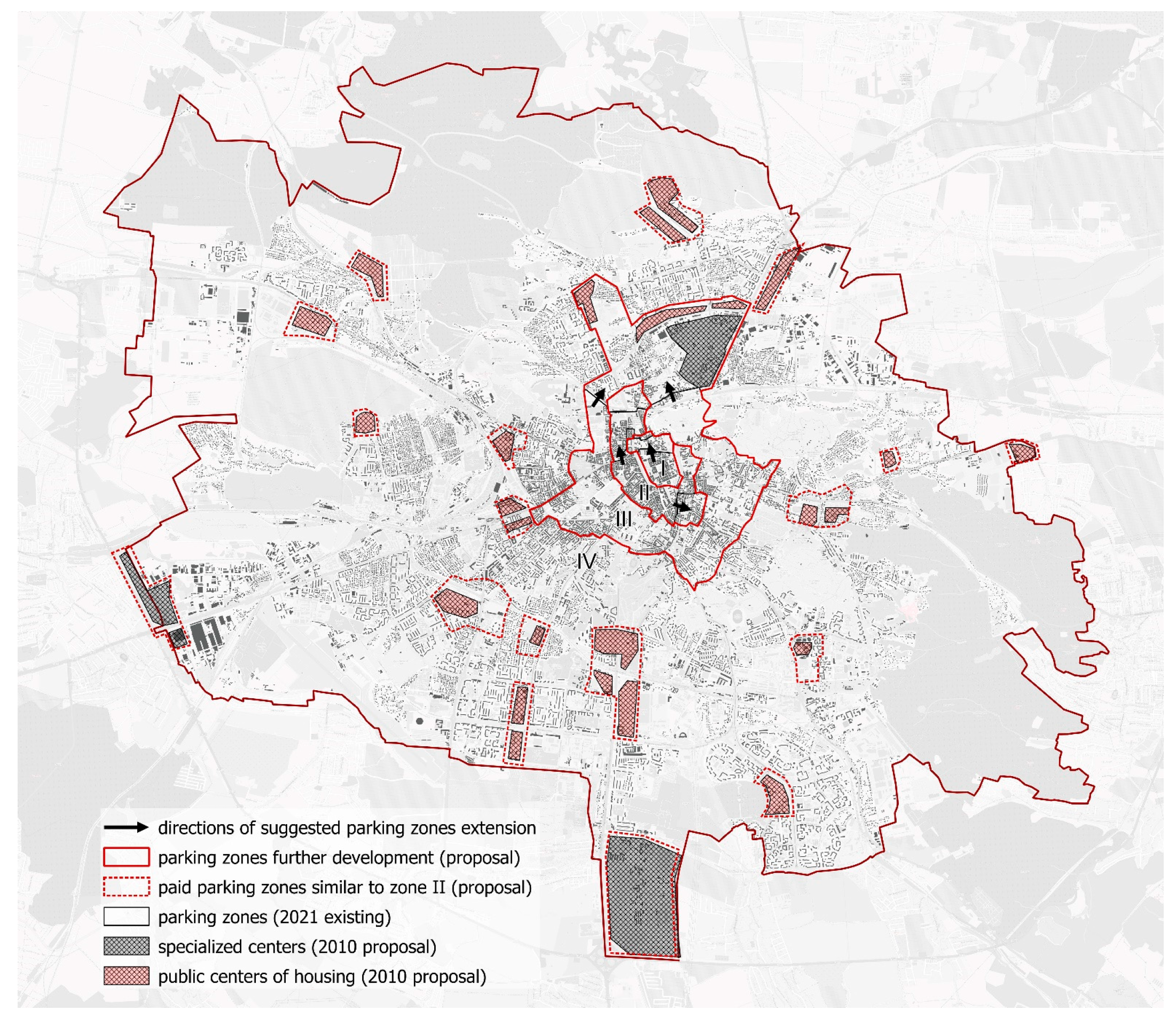
  • The expansion of the charged parking zone. As more and more drivers look for free parking spaces outside the charged parking zone, mainly in the residential areas, creating inconvenience for the residents, the local authorities decide to expand the charged parking zone. Usually, over time, the charged parking area covers the entire city center. For example, from 2003–2017, the charged parking area in Cracow doubled [29].
The third phase of “Parking policy as integral part of Transportation Demand Management (TDM) strategies” includes the following measures:
  • Supply restrictions. In this phase, cities reduce the number of parking spaces in the central part of the city to improve urban mobility by improving public transport, the cycling infrastructure, and the pedestrian communications. Copenhagen began to eliminate parking lots in the central areas as early as 1960, and during the 2000s, the number of street parking spaces in Paris decreased by 9% (by 14,300 parking lots) [2];
  • “Park and Ride”. Intercepting car parking lots are organized to limit the entry of cars arriving from the suburbs to the city during the daily labor migration. The survey of interceptor users in Strasbourg found that in the past 90% of them used only a private car to travel around the city, and four percent of tram passengers were interceptor users [1];
  • Differentiated parking tariffs. In this phase, the city sets differentiated parking tariffs depending on the demand. As a rule, the cost of parking increases with the approach to the city center, as well as in public subcenters. In the last decade, the differentiation of parking tariffs has gained in popularity, depending on the level of harmful emissions from cars [7];
  • The multiple use of parking facilities. The improvement of the efficiency of parking zones is achieved by providing the opportunity to share them—for example, multi-level parking in the city center can be used during the day to park visitors’ cars and at nighttime to park the vehicles of the residents of nearby areas;
  • The workplace parking levy. In some cities, municipalities impose a tax on the private parking spaces of (off-street) companies that are used by their employees. The study carried out in Paris showed that in the case of the taxation of free parking spaces for workers, 20% of drivers would travel to work on foot or by bicycle, 20% would go by public transport, 15% would share a car or take turns, 40% would seek for parking spaces away from the office, and only 5% would be willing to pay for parking [1].
Successful modern strategies for parking management in European cities are described by M. Kodransky and G. Hermann in their work “Europe’s parking U-turn: From accommodation to regulation” [1]. The authors split them into four groups: the first—economic mechanisms (pricing, the introduction of a tax on pollutant emissions, tax from employers for the parking of their employees, and the targeted reservation of funds); the second—regulatory measures (limiting parking spaces, setting a maximum of parking spaces, and regulating parking lots); the third—physical design (the installation of columns/pedestals, marking parking lots, changing the purpose of public places, and street geometry); and the fourth—quality of service contracting (the use of modern technologies—an electronic parking management system, cellphone payment, smart meters, and car scanners).
The modern approach is to use modern information technologies and concepts such as the internet of things (IoT) [30,31,32] to solve the problem of parking. In 1999, Kevin Ashton, an innovator and consumer sensor expert, coined the phrase “Internet of Things” to describe the network which connects objects in the physical world to the internet. Since then, smart connected objects have become a part of everyday life. According to Alexander S. Gillis, the internet of things, or IoT, is a system of interrelated computing devices, mechanical and digital machines, objects, animals, or people, which are provided with unique identifiers (UIDs) and the ability to transfer data over a network without requiring human-to-human or human-to-computer interaction. A thing in the internet of things can be a person with a heart monitor implant, a farm animal with a biochip transponder, an automobile that has built-in sensors to alert the driver when tire pressure is low, or any other natural or man-made object that can be assigned an Internet Protocol (IP) address and is able to transfer data over a network. In general, an IoT system can be used not only for data acquisition [31,32,33] but also for complex data analysis [34,35], ensuring its privacy [36] and safety [37,38].
The concept of IoT has also evolved to manage public transport. In many cities around the world today, real-time public transport monitoring and management systems (DIMO-FUH, MOVIA, NOMAGO, etc.) are successfully used under various trademarks [39]. The IoT concept in the field of parking management evolved into the so-called “Smart Parking system”.
The IoT smart parking system is a set of IoT sensors that are installed in parking spaces and monitor whether a free space for parking is available. The sensors are connected to a wireless network and send data to a server, which allows one to create an interactive map that is updated in real time and shows drivers the availability of spaces, the price, and the parking conditions, as well as paving the way for them. Drivers have the opportunity to temporarily reserve a place while driving to it, as well as to pay for the cost of the parking time. Today, an application for renting “Bolt” scooters has a similar function in Lviv. The round-the-clock monitoring by the smart parking system provides an opportunity to track the supply and demand of parking spaces and to identify certain patterns, with which it is possible to establish dynamic pricing. This is implemented in San Francisco, California [40]. The best implementations of the smart parking system, particularly in historic cities similar to Lviv, are described by Biyik et al. [41]. So, the next stage in the development of city parking is the introduction of the smart parking system, which is compatible with the IoT concept. It achieves two important goals—the ability to have the flexible management of parking conditions and the convenience of parking for drivers. Such a system has a significant impact on the transport network in the city as a whole, as it significantly relieves the traffic on city streets, which is caused by cars looking for a free parking space—the so-called phenomenon of “cruising for parking”. Current studies simulating this phenomenon show that 9–56% of the total car traffic is looking for a parking space, on average within 6.03 min [42].
The implementation of the IoT smart parking system should be preceded by the rational organization of street parking spaces, their placement on the street space, and the further accounting.
One interesting approach is proposed in this article [43]. However, it is designed for a smart factory, where the flow of cars is not as big and is less stochastic and more predictable, in contrast to that of a city. Therefore, the direct application of this approach in the city is hardly possible. Additional studies are needed to make a decision on whether this approach is suitable for the urban conditions of Lviv and what adjustments are needed to make this approach effective. These studies need a lot of space; so, they should be considered in a separate paper.

3. The Features of the Transport System of Lviv and Its Impact on the Problem of Parking in the Central Part of the City

The reason for the main global transport problems of Lviv, which exacerbate the problem of parking, is the short-sighted, sometimes chaotic planning development of the city. This has resulted in:
  • A very high density of urban development caused by the housing boom of 2010 [23] and, at the same time, the short length of the city streets;
  • An unformed system of city chords and bypass rings (transporting loads in the network, moving in transit through the center) [16] during the 20th century;
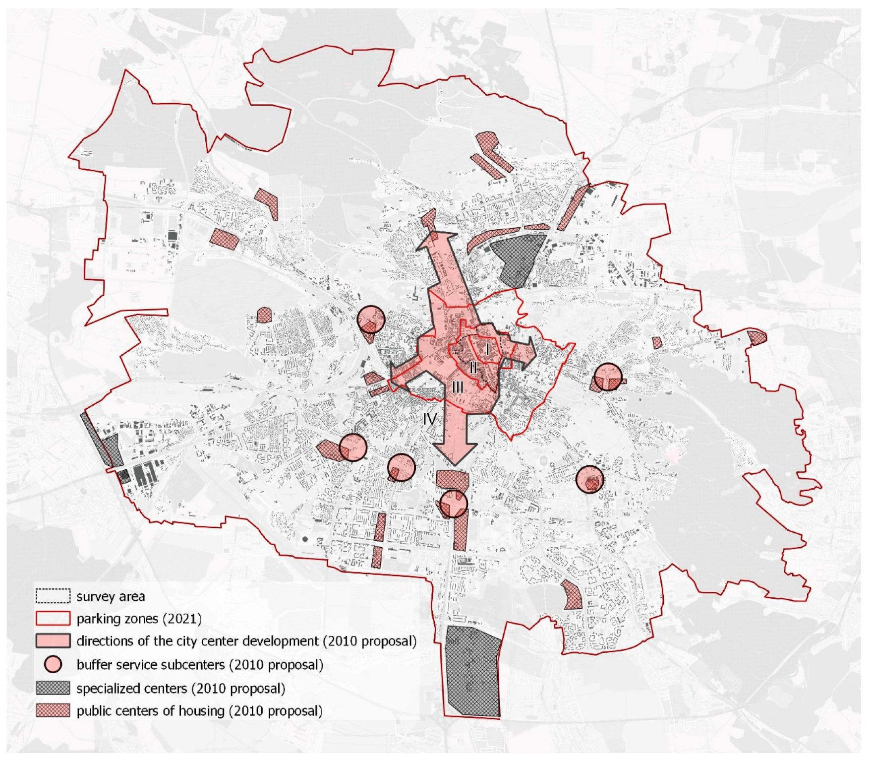
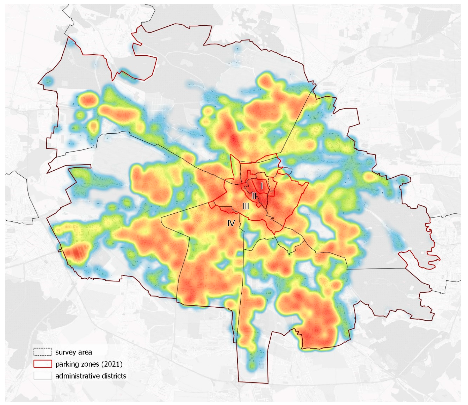
  • A historical center of high functional concentration (the historical center attracts a large amount of transport). The development of the “Lviv brand” focuses on the historical environment, which determines its filling with even more functions. In addition to the saturating of the city center of Lviv with tourist and cultural functions, the city center has a large number of commercial and business facilities [24]. In the historical core of the city, historical administrative buildings have been preserved and operate, e.g., the city council in the town hall and the Lviv regional state administration in the building of the former Galician governorate [44]. The oversaturation of the historic center of Lviv and the need to remove the functions that cause traffic congestion in the city center were justified in the 1970s [45]. The plans to create local subcenters have only been partially implemented, as a result of which the functional significance of the center remains to this day. The master plan of Lviv until 2025 envisages the creation of a new commercial and business subcenter in the Pidzamche district, which should be adjacent to the second transport ring in the northern part of the city. In addition, the development of new industrial areas is proposed in the city. Despite the plans, since the approval of the master plan in 2008, no progress has been made in the development of the planned subcenters;
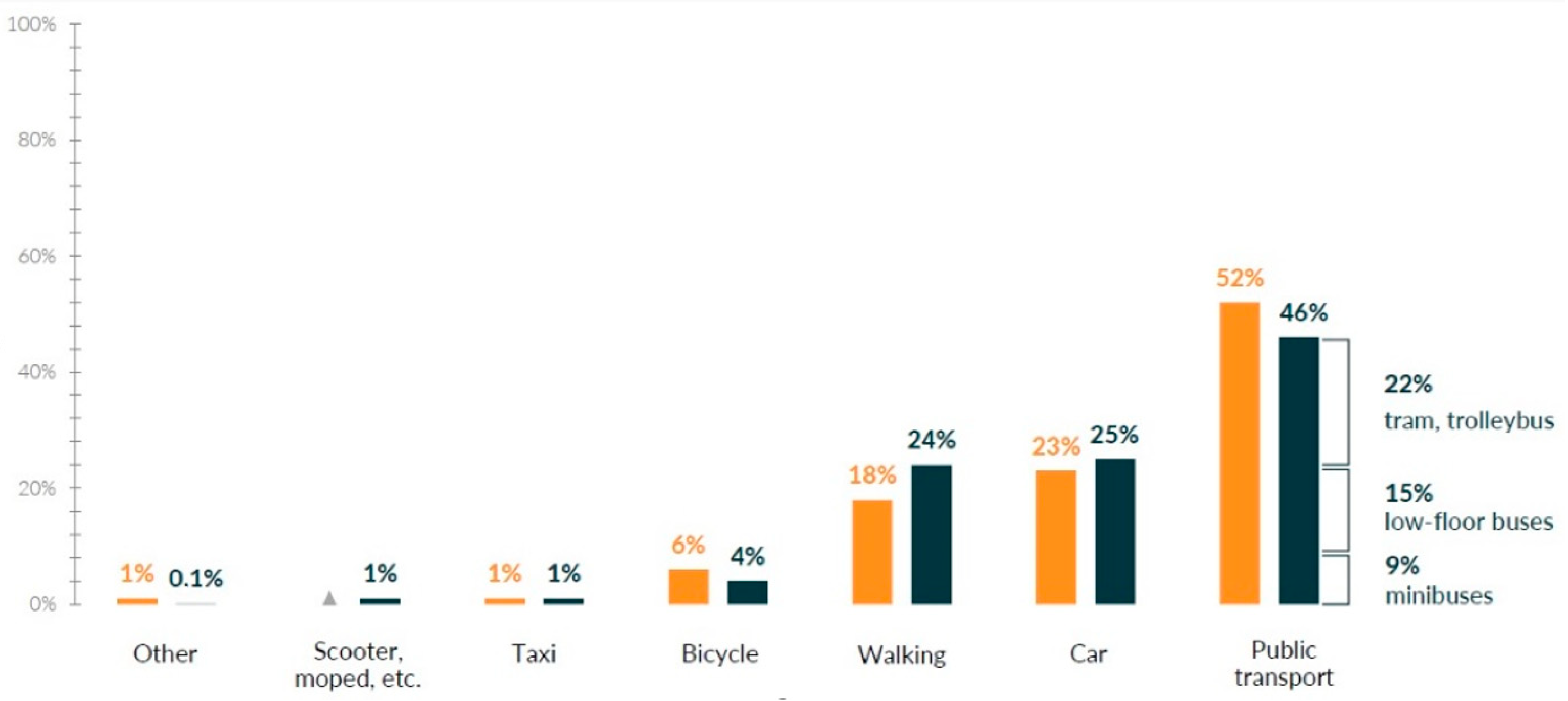
  • The improperly operating public transport network and the currently underdeveloped bicycle network further aggravate transport problems, which further motivates the use of private vehicles in the historic city center;
  • The rise in the motorization level (the annual rise of 10% [46]).
Historically, the planning structure of Lviv was formed on the main radial routes, which were concentrated in the city center. After the dismantling of the medieval walls, which began in 1777, a circular “street around the city” was formed in their place, which still performs transport and walking functions. Later, the planning structure continued its development on the basis of radial roads, also forming cross-links between them [17].
Today, the main highways of Lviv, including the international highways and the highways of European importance, are included in the structure of the city and cross the city center of Lviv, loading the historic city center with transit traffic.
The Lviv bypass roads consist of three traffic rings:
  • The first ring took place on the site of the former medieval walls, which were completely dismantled in 1825;
  • The second ring was formed approximately on the border of the territory, which was built in the interwar period (before 1939) and runs at the distance of 1.5–4.5 km from the first ring. The existing route of the ring does not correspond to the plans of its development, which were laid down in the Soviet period. Due to the variable number of street bands of the second ring, the band widths of the different fragments vary [18];
  • The third ring is a bypass road, built in the 1980s; it passes at a distance of 8–10 km from the historical core of Lviv and has an unfinished northern fragment. The absence of the northern part of the bypass induces long-distance transit through the central part of the city, and the considerable distance of the second transport ring from the historic core makes it virtually impossible to move within the city via the other way rather than through the historic center of Lviv. In fact, in the planning structure of Lviv there is no active ring that would bypass the city center, the presence of which is typical of similar historically formed cities (e.g., the second ring in Leipzig and Cracow).
According to the research carried out in 2018 on the basis of the analysis of the data provided by the geographic information system (GIS) and the use of OpenStreetMap (OSM) data [19], a comparative analysis of the parameters of the road network of three similar cities was performed. The cities of Leipzig and Cracow, which are similar in terms of planning structure, historical development, and population, were chosen for comparison with Lviv (see Table 1).
Thus, the street network length per 1 inhabitant is 55.47% in Lviv and is 50% shorter than in Leipzig and Cracow, respectively. These numbers are expressive and clearly characterize the low potential of the city for the needs of private cars and, in particular, for the needs of the development of a large number of on-street parking places, which will cause a transport collapse, especially in the historic part of the city.
As the previously mentioned study showed [19], the alternatives to private transport mean that transportation in Lviv is also “lagging behind” in comparison with the similar cities. The fact that the length of the lines of highly mobile and capacious modes of transport in Lviv is 67.61% less than that in Leipzig and 55.77% less than that in Cracow is vivid.
Nowadays, the public transport network of Lviv tries to compensate for this demand by bus transportation; so, transport services in the peripheral areas are carried out only by bus and partially by trolleybus routes. The bus network is mostly served by small buses of small passenger capacity (“minibuses” or “route taxis”); large buses are available only on the radial routes [47]. The problem of the uninterrupted operation of the bus and trolleybus connections is the movement by mostly common carriageways along the streets, together with the private vehicles.
The density of the bicycle network in Lviv is increasing every year and is commensurable with that in similar cities. However, there is still a frequent problem of the bicycle network with the inconsistency of the connections, which are often intermittent and have no continuation. These figures indicate a low level of infrastructure for the sustainable urban transport, which will encourage its use.
The study of different modes of transport use in the cold period of the year (2019 and 2021), carried out within the framework of the Lviv Sustainable Urban Mobility Plan, included the survey of 800 people aged 14 and older. The geographical coverage was of Lviv and four communities of the Lviv agglomeration: Vynnyky, Rudno, Bryukhovychi, and Dublyany. There was found to be a rise in the number of residents who preferred walking (+6%) instead of using public transport (a decline of −6%, respectively), even in the cold period of the year (Figure 1). This tendency is related not only to the poor public transportation services, but also to the achievement of the city council’s promotion campaign of Lviv as “the city of short-walking distances” (up to 8 km from the center to the city border). These results are very picturesque and show the potential for the further development of the walking and bicycle infrastructure, while simultaneously implementing measures for limiting the use of cars.
The Sustainable Urban Mobility Plan has been developed by Lviv utilities since 2018 within the framework of the international project “Integrated Urban Development in Ukraine I, II” of the German government company “Deutsche Gesellschaft für Internationale Zusammenarbeit (GIZ) GmbH”. It sets out the prospects for each group of transport users. For the drivers of private cars, this means a sufficient number of lanes for continuous traffic, multi-level interchanges, the absence of traffic lights, measures that reduce speed, a good markup and arrangement of signs, the most direct ways for quick movement, the absence of other road users, and free parking [26].
In general, the peculiarities of the urban development of Lviv create a very limited potential for the development of the city for the needs of private transport, especially in the historic center. It is worth noting that the limited amount of parking spaces that are organized in the dense conditions of the streets of the historic part are particularly scarce; so, they should be subject to strict conditions and a high cost of parking, i.e., the short-term rent, in fact, of 15 square meters of urban land, which in Lviv is much less available than it is in similar cities.

4. Methodology

The sociological survey carried out in 2014 showed that 39% of the inhabitants owned a car, whereas in 2019 the number of car owners had already reached 43% [48]. Over 150,000 cars were registered in Lviv in 2018 [49]. The mayor of Lviv argues that the number of cars rises by 10% annually [46]. Thus, at the end of 2021, we can presume that there are at least 200,000 cars among the 721,500 inhabitants [50], i.e., 277 cars per 1000 inhabitants.
The methodology of the study is as follows. We counted the number of potential on-street parking spaces using the size of the standard parking space (6.0/2.5/3.0 m (parallel/perpendicular/at an angle of 60°)) and found some potential parking spaces in the places that do not violate the acting traffic codes. Having counted all the parking lots, the IoT-based system can be implemented.
The aim of this article is to analyze the current state of on-street parking in the central part of Lviv and the progress of its development over the past 5 years (2016–2021) as Lviv has made significant progress, in particular due to city policy, including a project of on-street parking in the central part of the city, developed in 2016 [20]. The article outlines further prospects for the creation of an IoT smart parking system, the implementation of which is impossible without the rational organization of the street parking lots, their placement in the street space, and the further accounting. The study is limited to on-street parking lots in the central part of the city and excludes the ground of off-street parking lots and the carparks located in buildings (garages).
The first stage of the “in situ” research was conducted by the authors of the article in 2016—on-street parking was surveyed on 78 streets in the central part of Lviv (19 in the pedestrian zone, 59 outside the zone). The choice of 78 streets was conditioned by the proposed “short-term entry zone”, the boundaries of which were laid out by the project of the arrangement of on-street parking commissioned by the Lviv City Council (LCC) [20]. The purpose of the field surveys was to identify:
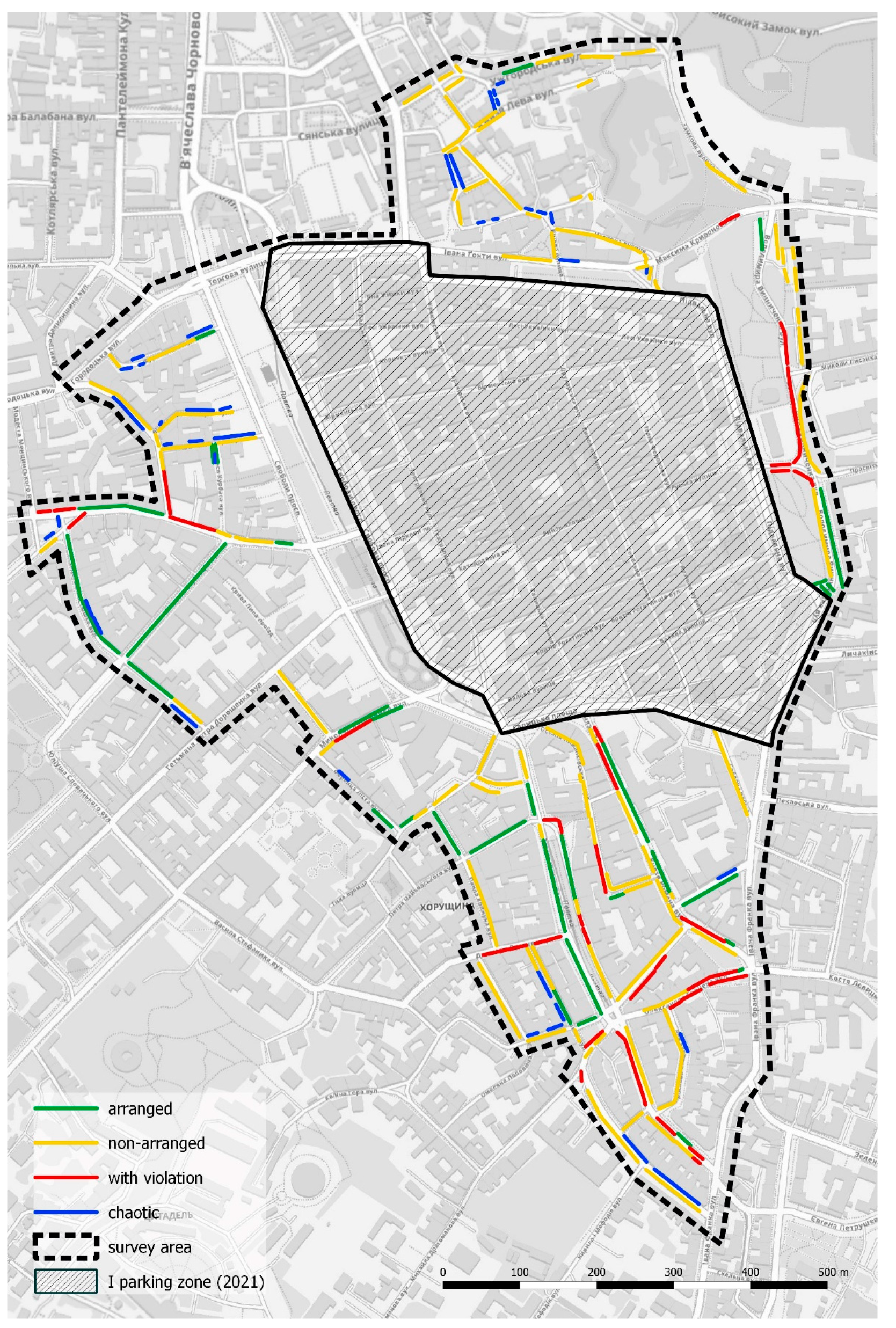
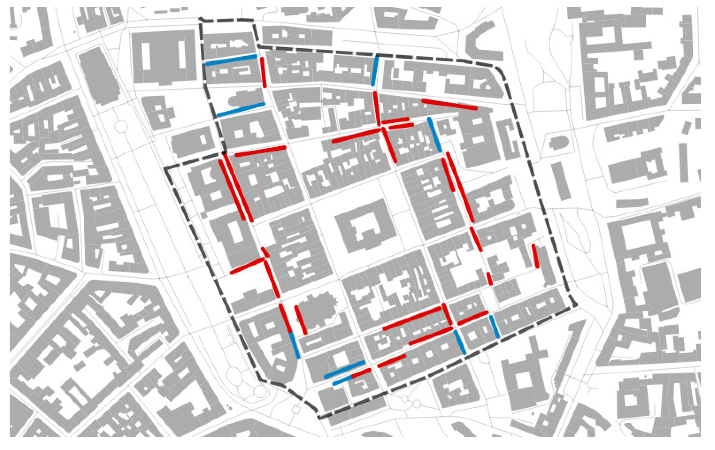
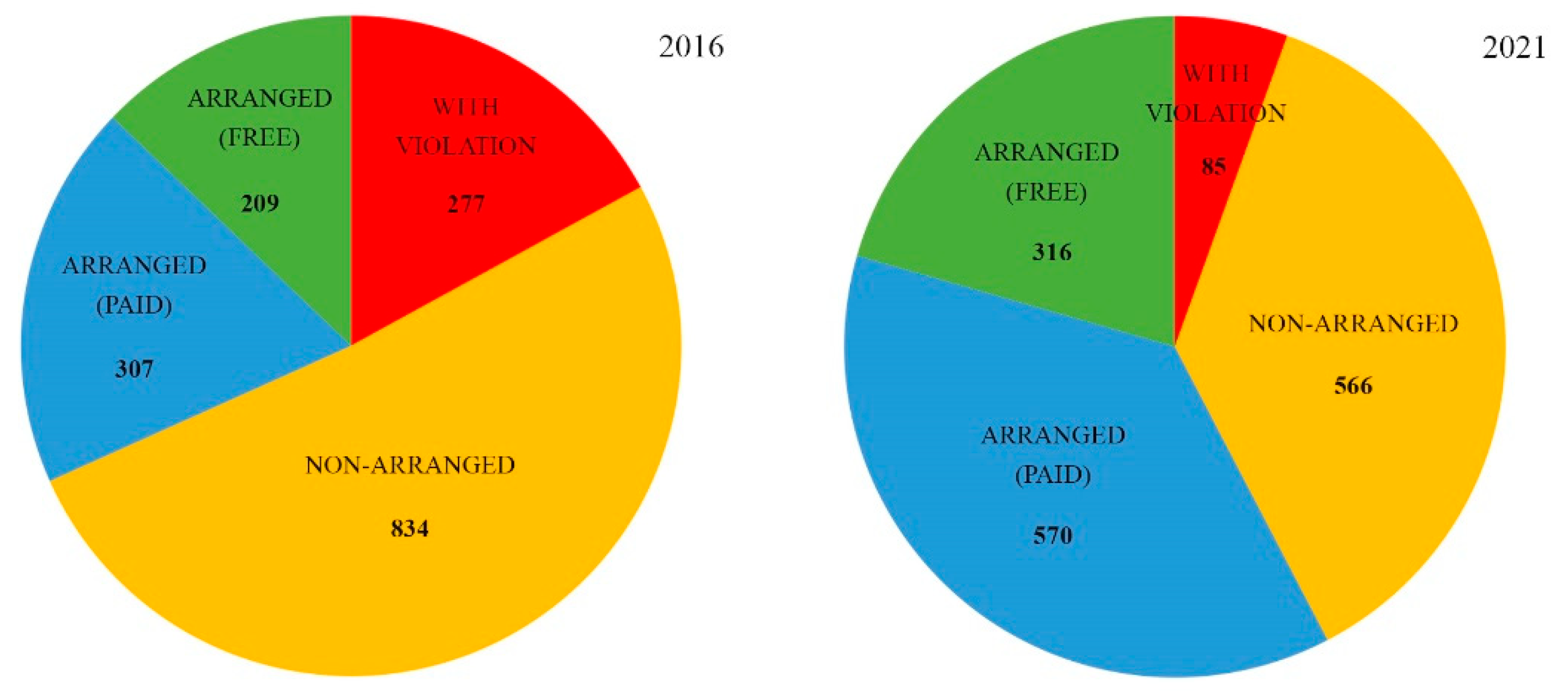
  • The number of arranged parking spaces;
  • The number of non-arranged parking spaces (in which the cars were parked without traffic violations);
  • The number of parking spaces with a violation of traffic regulations.
All the studies were carried out during working hours from 8 A.M. through to 7 P.M., i.e., during the time of the highest demand. During the pilot study, it was difficult to determine who owned the cars—visitors or residents, as most drivers (when available) refused to answer this question. Moreover, the official services do not have such information, as the residents often do not live at the place of registration, and the cars are often owned by others.
Additionally, we revealed streets with chaotic parking spaces (hitting the sidewalks, green lanes, bike paths, etc.). The investigated parking places were put on the scheme of the on-street parking of the central part of the city. The results of the study became the basis for the development of a project for the arrangement of organized on-street parking spaces in the central part of the city.
The second stage of the “in situ” research was repeated in 2021. On 4 June 2019, the Executive Committee of the LCC approved the “Concept of Lviv Public Transport Development and Parking in Lviv”. Accordingly, the Lviv parking areas have undergone significant changes compared to those of 2016. The “short-term entry zone” (proposals for the short-term entry of cars into the projected area [20,27] were not implemented), which was proposed in 2016 in the project [20] has evolved into today’s “parking zone II” and now covers 1.1 km2 (excluding “parking zone I”). For comparison, “parking zone I” in 2016 was placed on just 0.75 km2 (excluding the “pedestrian zone”), and the project of the “short-term entry zone” proposed to cover 0.65 km2 (excluding the “pedestrian zone”) (see Figure 2).
In the article, the authors identify, by the method of field surveys, the number of on-street parking spaces on 46 streets in the central part of the city, the choice of which was determined by the projected “short-term entry zone” in 2016, excluding the modern “parking zone I” (which completely covers a pedestrian zone plus a few adjacent streets of the historical city center). The authors assessed the progress of the arrangement in comparison with: (a) that since 2016 and (b) the project proposal of 2016. In addition to expanding the parking area and the amount of parking lots, it also considers progress in the development of the legal framework for parking and its compliance with modern world practices, and it evaluates the problems of and the prospects for the creation of the IoT-based smart parking system.

5. Results and Discussion. Determining of the Planning and Spatial Characteristics of On-Street Parking as a Basis for the Formation of IoT Smart Parking System in Lviv

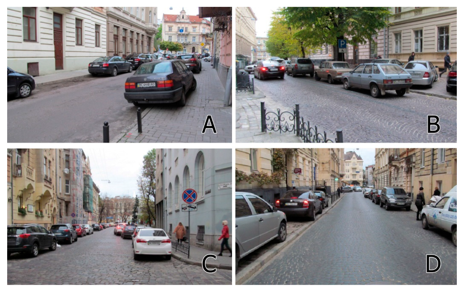
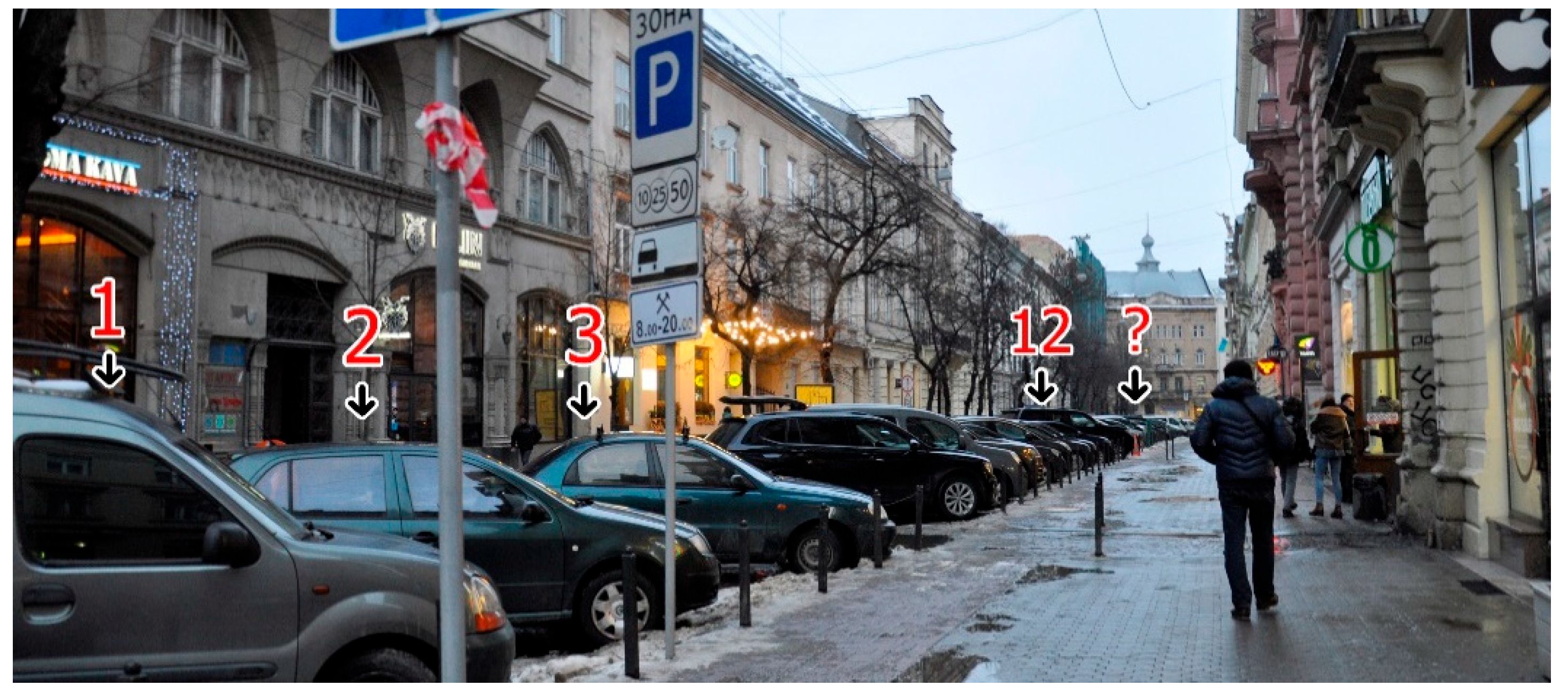
5.1. Problems of On-Street Parking in the Central Part of Lviv in 2016

The demand for parking varies considerably in different areas of Lviv. However, the supply of parking lots in the center of Lviv (zone 2) is significantly lower than the demand, and this imbalance is the reason for the need to find as many parking lots as possible, as well as to expand the area of the charged parking spaces. The demand is created due to the multifunctional uses of the center: the educational institutions, administrative buildings, restaurants, hotels, etc., are located here, and most of them do not have their own parking spaces.
Given the functional concentration in the historic center of Lviv, car parking of the type “park and walk” should provide for the need for temporary and long-term parking. Despite this, there were only 3 parking lots of this type in the city center, with a total of 186 parking spaces (the parking lot on Voronoho Street had 35 parking spaces; “Vernisazh” had 73; and Valova Street had 78), 2 of which were reserved for charged parking on the parts of the streets which were isolated from the traffic in the historical core of Lviv: 1—the parking lot on Valova Street and 2—the parking lot “Vernisazh”, within the streets of Virmenska, Teatralna, Lesi Ukrainky, and Nyzkyi Zamok [53]. Some public facilities in the city center that have their own carparks (the Rius Hotel, 12A Hnatiuka Street, and the FORUM LVIV shopping center) offered public parking services, but with operating mode restrictions. For example, the Rius Hotel offers only daily payment [54], and the parking lot of the FORUM LVIV shopping center is open from 8:00 to 2:00 and is targeted at its own visitors [55]. According to the official data, within the central part of the city (parking zone I) there were only 138 paid on-street parking spaces [51].
An inventory of the on-street parking lots in the central part of the city (within the limits proposed for the “short-term entry zone”, not including the pedestrian zone [27]), conducted by the author from October–November 2016, revealed a total of 2289 parking lots (as part of the project “Project development of the on-street parking places, parking lots and garages”. Developer—PPVP “Arkhnovo”, 2016 (the author’s team: H. Petryshyn, S. Tupis, N. Sosnova, I. Skliarova, R. Liubytskyi [20]). The customer was the Department of Housing and Infrastructure of the Lviv City Council [20])). Of these, 784 (34% were designated as parking lots by the municipality and 1050 (46%) were the lots of the allowed parking lots, with no prohibition signs installed (“parking is prohibited” or “stopping is prohibited”). The field surveys revealed 455 on-street parking lots (20%) located in prohibited places under the road signs “no parking” or “no stopping”, as well as chaotic parking on the sidewalks and lawns [20]. Due to the lack of alternatives for on-street parking in the central part of the city, the main load fell on 46% of the parking spaces, which were free and did not have established rules and conditions of parking. Free, unregulated parking in the city center led to significant financial losses for the city and encouraged the use of cars [44,45]. It was found that the developed projects of on-street parking in the central part of the city provided 30% of the free-of-charge parking lots, which is unacceptable in conditions of high demand [18].
The on-street parking of 46 streets, the detailed research of which is limited in this article to the borders of the projected “short-term entry zone” in 2016, excluding the modern “parking zone I”, in 2016 contained a total of 1627 parking lots: 516 (32%) were designated as parking lots by the municipality; 834 (51%) were lots of allowed parking (with no prohibition signs installed); and 277 (17%) involved parking in prohibited places (see Figure 3 and Table 2).
There were two parking zones in Lviv (see Figure 2A), on which the hourly cost of paying for parking depended. Car parking within the zones was paid only in the period from 8.00 to 19.00, and it is worth noting that paid on-street parking spaces were available only on some streets of the first zone [53]. The exceptions were the “park and walk” parking lots of “Vernisazh” and the parking on Valova Street, where the fee was paid through the entrance/exit terminals [53].
Until April 2016, the cost of parking was USD 0.15 per hour on all parking in the city center. From April 2016, the cost became USD 0.30 per hour in the parking lots (“park and walk”) and USD 0.23 per hour on all on-street paid parking in parking zone I [56]. From the beginning of 2018, the cost of parking rose by almost three times—up to USD 0.70 per hour for parking in the parking lots and up to USD 0.52 per hour for the charged on-street parking spaces of parking zone I [57].
The parking zones in Lviv are conditional and do not have clear territorial boundaries within which all on-street parking is charged (as in Leipzig or Cracow). Much of the on-street parking spaces in the central part, as in the rest of the city, are free of charge and not regulated in any way, due to the lack of a ban on parking in places where no prohibition signs are installed [58]. Zone II, in 2016, was the territory outside zone I, which formally covered the entire city, but in fact it regulated only the price of individual on-street parking spaces. As mentioned earlier, an inventory of on-street parking in the central part of the city revealed 455 (20%) cases of parking in prohibited places (within the scope of the prohibitory signs), due to the impossibility of issuing a fine without the personal presence of the offender and the exclusive right to monitor compliance with parking rules by the national police [59]. The significant number of free-of-charge on-street parking spaces in the central part of the city and the limited possibilities to punish violators in 2016 caused the excessive demand for parking lots, which provoked difficulties in traffic and pedestrian movement [60].
Special parking conditions were applied in the pedestrian zone of the city in the historic center, where residents and property owners were allowed to park subject to a permit issued by the city council. In addition, the right for free temporary entry into the pedestrian zone of the city was provided to the vehicles of residents and businesses of the pedestrian zone from 6.00 to 8.00 (charged—from 8.00 to 11.00) [60]. Parking was only allowed on certain streets, but due to the large number of provided permits, it was often found elsewhere. A field survey of parking within the pedestrian zone in November 2016 revealed 319 street parking spaces, of which 80 were permitted parking spaces (25%), and 239 were additional parking spaces in the prohibited areas (75%), indicating ineffective management and the optional observance of the parking rules (see Figure 4) [20].
The problems of parking were the most acute in the central part of the city, which accumulated traffic flows and was not able to meet the demand for parking. The lack of a strategy for regulating parking in the city in the face of a pronounced shortage of parking lots and weak rules and conditions led to spontaneous and uncontrolled on-street parking (see Figure 5).

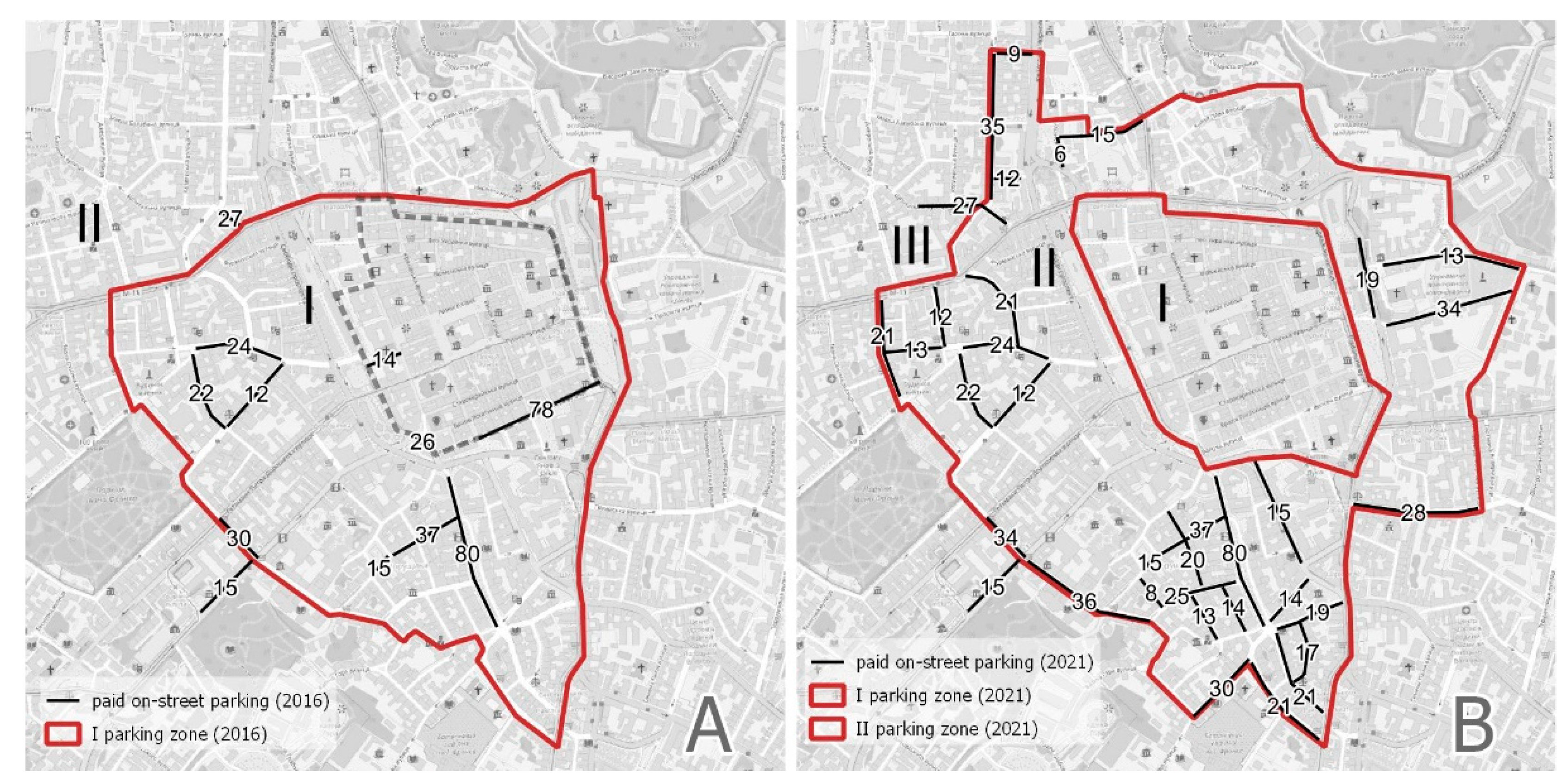
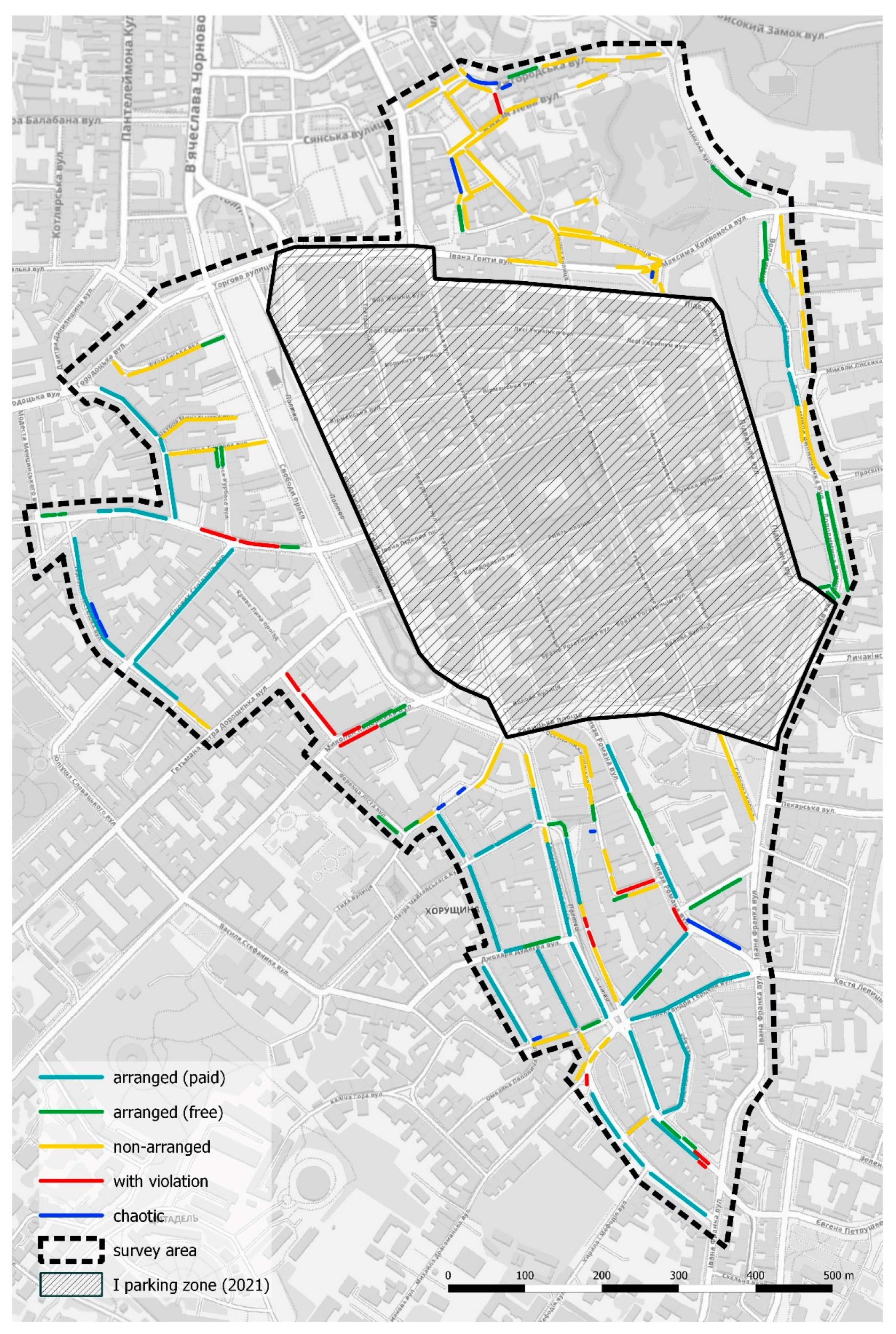
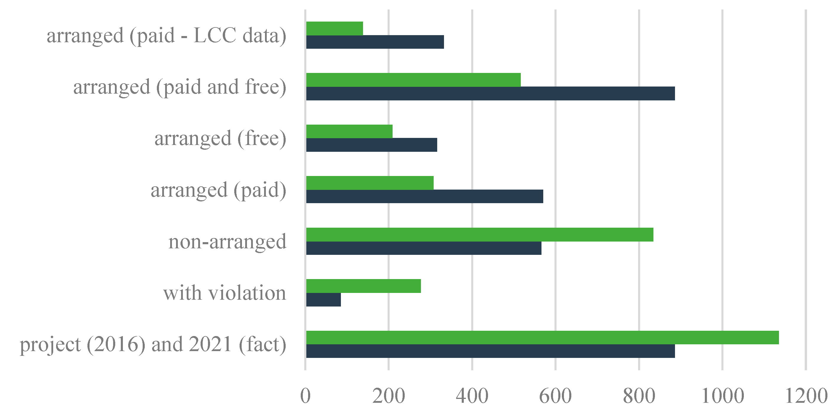
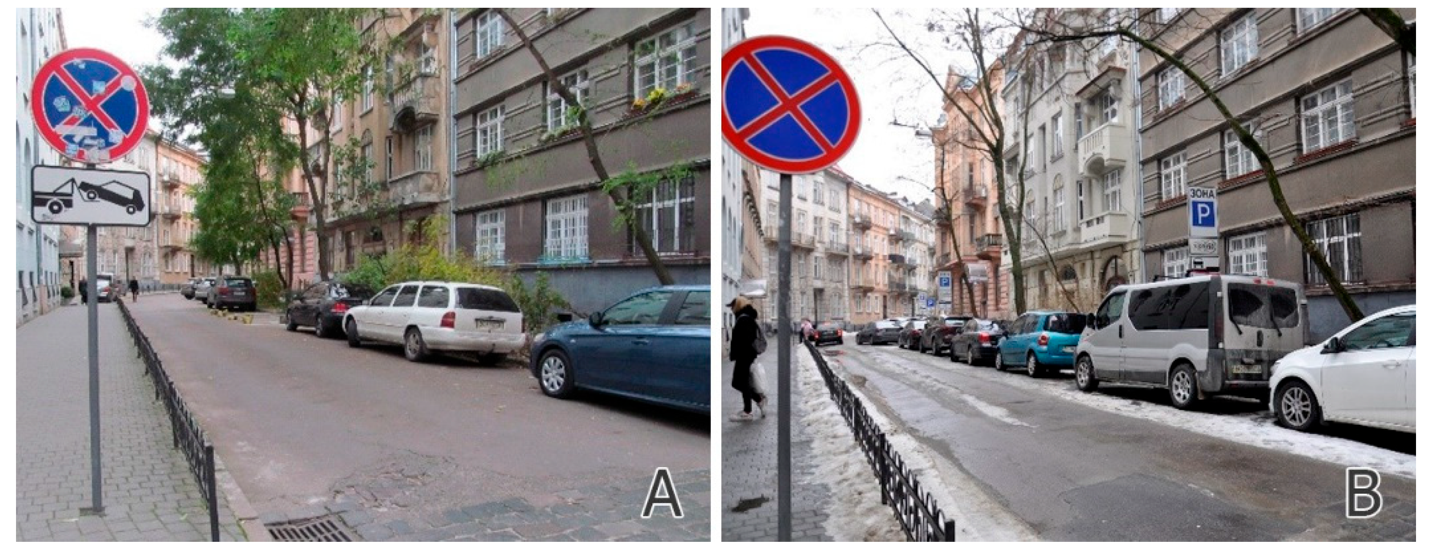
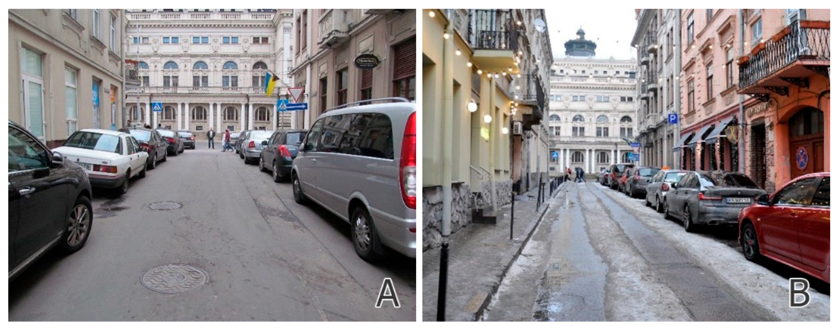
5.2. Progress in the Development of On-Street Parking from 2016–2021

The formation of a network of parking facilities should be split into stages and primarily aimed at the solving of the most acute problems. First of all, it is strategically important to organize system elements (“park and ride” or “park and walk” parking lots and allowed parking zones), which are aimed at reducing the load on the historically formed part of the city and the development of a balanced transport system.
The first stage in the formation of a full-fledged network of parking facilities in the historically formed city is the arrangement of controlled parking zones in the central part of the city. Charged on-street parking with certain rules, conditions, and strict inspection allows the elimination of chaotic parking [6] and makes the residents aware that the street space in the central part of the historically formed city has high social and economic value and can be used in other ways [21] Instead of an on-street parking lane, it is possible to design the widening of the carriageway or sidewalk, a public transport or bicycle lane, a “parklet” or taxi stand, a green lane, etc. The arrangement of an inspected parking area does not require significant financial costs but significantly contributes to the sustainable mobility of the historically formed city and can influence the behavior of private car drivers in five different ways: finding an alternative parking lot; starting the trip at another time of day; changing the type of movement in the city; changing the place of destination; and avoiding travel altogether [8].
The arrangement of an inspected parking area is a transitional stage and should be accompanied by the construction of “park and walk” parking lots, with the subsequent elimination of on-street parking spaces to expand the pedestrian zones, sidewalks, green lanes, etc. In addition, the absence of on-street parking in the historically formed city center contributes to the aesthetic perception of the environment, which has a positive impact on the tourist potential of the city.
For example, the creation of an inspected parking area in Vienna has reduced the mileage of private cars looking for a street for car parking from 10 to 3 million kilometers, increasing the use of bicycle and public transport by 25% [1]. The effectiveness of parking areas is also confirmed by a study in the UK, which found that an increase in parking prices reduced car use by 20%, and the reduction mitigated on-street parking by 30%. In contrast, improved public transport services reduced car use by only 1–2% [13].
Unreasonable spatial solutions of parking objects in the territories of historical areas can cause architectural problems that may arise due to the uncharacteristic visual intrusion into the historical environment. First of all, the problem concerns the territory within the second transport ring (the central parking zone), whose buildings have the greatest historical and architectural value. The main spatial type of parking in this area should be off-street underground and multi-level parking lots (garages). Off-street parking lots in the central zone should be considered only as a temporary reserve of the territory for the construction of multi-level parking lots, given the high cost of land and the visual dissonance in the historic area. The main principle of the design of multi-level parking lots in the historic area is that it should be the least invasive in terms of architecture and engineering, minimizing the negative impact on the valuable historical environment.
Considering the problems of the on-street parking in 2016, the project to arrange on-street parking spaces in the central part of the city was developed [20]. In the area of the proposed “short-term entry zone”, field surveys (the field survey was conducted by R. Liubytskyi from October–November 2016) revealed only 784 specified parking spaces. In other places, the parking was carried out in places not provided for this purpose. The analysis of the territory revealed that even with the preservation of the existing organization of traffic, it was possible to provide 1616 additional on-street parking spaces that would not complicate traffic and pedestrian movement. In places of chaotic parking on the sidewalks, the installation of restrictive devices—columns, pedestals, etc.—was proposed. The proposed planning organization should have been accompanied by the establishment of the rules and conditions of on-street parking (tariffs, time limits), which had to be set so that some parking spaces remained free of charge—optimally 15% [6]. The arrangement of on-street parking spaces in the historically formed part of the city does not require significant financial costs, but it can make a significant contribution to the reduction in the traffic load in the city center, and it can promote the use of alternative modes of public transport.
As of 2021, the “short-term entry zone”, which was proposed in the project in 2016 [20], has evolved in today’s “parking zone II” and covers the area of 1.1 km2 (see Figure 2B,C). In just 5 years, the number of arranged on-street parking spaces on 46 surveyed streets has increased by 370 (from 516 in 2016), and now there are 886 parking spaces (see Figure 6, Figure 7, Figure 8 and Figure 9 and Table 3). The official count of the charged on-street parking shows a quantity mismatch in comparison to the “in situ” results (see Figure 6B Figure 10). The most typical measure of parking spaces increase was arranging of legal spaces in places that don’t violate traffic codes with the elimination of chaotic parking spaces simultaneously (see Figure 11 and Figure 12).
The logic of the pricing policy is as follows: the closer the car is parked to the city center, the more expensive the service should be, because there is less supply and higher demand. Therefore, in zone I the parking price is the highest at 0.75 USD/hour. The local residents also pay for parking, but at special prices, e.g., they have a choice to pay either 0.11 USD/hour regardless of the parking area or buy a half-year subscription for 53.23 USD/six months (see Table 4). The residents of the Lviv city center can park their cars free of charge in the evening (from 7 P.M. to 8 A.M.) and on weekends (according to the Sustainable Urban Mobility Plan in Lviv). That is, parking is 14 times cheaper for the local residents. This approach increases the demand for parking spaces from visitors; so, in 2020 the problem of increasing prices for visitors up to 1.14 USD/hour was debated [61].
The current prices, which are favorable for local residents, have led to the situation that on-street parking does not meet the demand of visitors to the city center, who create additional traffic while searching for free parking spaces, as well as using prohibited activities and places (parking in the middle of the roadway with emergency lights on, parking in the second row and blocking the first one, parking in the yards of residential buildings, parking on sidewalks and greenery, etc.). The level of prices is set by the city council in response to demand, but nowadays the local authorities in Ukraine do not have enough authority in the pricing policy and must follow by enacting legislation which governs economically reasonable tariffs [62].
The perception of local residents who own cars and travel around the city is unequivocal—there are not enough parking spaces in Lviv, and the local authorities do not make enough efforts to construct multi-level parking lots [63]. In addition, they are angry due to the need to pay for parking. Drivers and lawyers often try to find ways to avoid paying fines [64]. A director of the Lviv road department claims that almost 50% of drivers try to avoid paying for parking in paid parking spaces, and they intend to solve this situation only at the end of 2021 by implementing an automatic system for checking for proof of payment by license plates [65].
The generalized narratives of local car owners can be expressed as follows: “there is nowhere to park our cars”, “why should I pay for on street parking?”, “the city does not care about car owners because it does not construct parking lots”. Let us try to answer these narratives from the point of view of urbanism. Indeed, during the decade since Lviv’s master plan was approved in 2010, no multi-level or underground parking lots were constructed due to the extremely high cost which is caused by the difficult geological conditions. These difficult geological conditions, for example, stopped the construction of the underground tram in 1989 because of cracks in the Potocki Palace when drilling a mine 25 m deep nearby [66,67]. However, even if all the planned multi-level parking lots were built, it would solve the parking problem only partially. More parking spaces attract more cars, which complicate traffic and cause traffic jams in the central areas. That is why in world practice it is customary to limit parking in urban centers [1]. The answer to the question “why should I pay?” is related to the need to balance supply and demand, and the motivation to use another type of transportation, and “nowhere to park” means that demand is too high and prices in the central areas are too low.
In general, the current parking policy in the city seems reasonable, providing stricter rules in the areas with greater demand for parking spaces. However, in any case, it is impossible and unjustified to fully meet the demand for parking spaces in the central areas of the historic city according to the European trends of prioritizing pedestrians, cycling, and environmentally friendly public transportation. Charged and limited parking permits for residents in the areas of greatest demand and expensive parking for visitors will motivate the use of other kinds of transportation. Thus, it is extremely important to improve them. Developed public transportation accompanied by intercepting parking lots (“park and ride”) on the edges of the city and “park and walk” parking lots in the vicinity of the city center can solve not only the parking problem but also positively affect the whole transport network.
The parking organization in Lviv requires further improvement. The regulations and projects developed for the central part of Lviv can be applied to other areas of the city because of the redistribution of the central and local functions as well as the increasing population density.
Since the 1970s, a polycentric structure has been developing in Lviv. The master plan of Lviv, approved by the city council in 2010, is valid until 2025. It continues the tendency of its predecessors to develop the city center in the northern direction and creates public subcenters in the western, eastern, and southern directions (Figure 13). In addition, this master plan intends to create several buffer subcenters and three specialized subcenters: the commercial and business subcenter in the northern direction between Zhovkivska Street, Lypynskoho and B. Khmelnytskoho streets, the sports quarter in the southern direction near the Lviv-Arena Stadium on Stryiska Street, and the shopping quarter at the intersection of Gorodotska Street and the ring road in the western direction.
The growing density of buildings induces a scarcity of funds for the availability of street parking spaces. During the last decade, there was a construction boom in the largest cities of Ukraine (Kyiv, Kharkiv, Dnipro, Odesa, and Lviv). In the new areas, multi-story residential buildings (9-16-22 floors) have been constructed. Due to the desire of developers to reduce the cost of construction, the new buildings are supplied with much fewer parking spaces than the building codes of Ukraine require. Residents must park their cars on the nearby streets.
The population density of the urban areas is a direct prerequisite for determining the demand for parking. Based on the population density diagram in Lviv, we can draw the conclusion that the greatest demand for parking is in the central historical part of the city, where this study was carried out (parking zone II). Along with the greatest demand, it has the least potential for creating additional parking lots and spaces, due to the high density of valuable historic buildings. Similar to the historic center in terms of high population density are the predominantly 9-story neighborhoods of the Soviet period, which are located mostly in the southwestern and northern parts of Lviv. They are separated from the historic center by historic villas. It is obvious that these densely populated neighborhood “islands” will form their own subcenters (as confirmed by the proposals of the Lviv master plan (Figure 14)) and will have a high demand for parking spaces, similar to the one in zone II.
Having analyzed the demand for parking spaces with respect to population density and the development of public subcenters, it is possible to forecast the further development of parking areas (Figure 15). In the central part of the city, there is a need to transform the current parking areas. The expansion of zone I (the pedestrian zone) affects the expansion of parking zone II, especially in the northern direction. The need to develop the pedestrian area in the northern direction is justified by the inclusion into its boundaries of the oldest part of Lviv, which preserves the first market square of the city and the oldest sacred buildings of the XIII–XVI centuries. Moreover, numerous decisions of the city council proposed to create pedestrian streets in the vicinity of the historic center (e.g., Kulisha Street and others), which will exclude parking lots.
According to the master plan, it is proposed to extend parking zone II by the development of the Lviv city center in the northern direction along Chornovil Avenue. The master plan envisages the saturation of this territory with service facilities of city importance. In addition, it is necessary to expand parking zone II to the quarters along Levytskyi Street (the southeastern direction), which has high building density and is directly adjacent to the historic center of Lviv. This approach will create “rings of parking zones” that correspond to the historically formed radial-circular structure of Lviv and meet the demand for parking spaces with respect to the population density and the saturation of public functions.
Parking zones III and IV with the least strict rules need another organization. Due to the increased demand for parking lots in the public, buffer, and specialized subcenters of the city, it is proposed to create special charged parking zones similar to those of zone II in order to implement the IoT-based parking system. The implementation of the Sustainable Mobility Plan in Lviv stimulates the focus on public transportation, encourages pedestrian zones and bicycle routes, and optimizes the city’s transport and pedestrian networks and their use. Parking management should be an important component of the Sustainable Mobility Plan.
It should be noted that the IoT-based smart parking system also has certain limitations and drawbacks that should be taken into account when planning its implementation.
First of all, the implementation of the IoT-based smart parking system should be carried out in the parking lanes of those city streets whose redesign or reconstruction is not planned in the future. This is due to the high cost of installing, configuring, and maintaining such a system, which can be considered as the most significant limitation. It is clear that the implementation of this technology should start in the areas with the greatest demand for parking so that the system will pay off in the long run, as well as positively affect the most problematic areas of the city in terms of transport. In the context of the city of Lviv, such a territory is the existing parking zone II, which, according to the authors, should be expanded in the nearest future. It is also reasonable to install this system outside parking zone II, in the areas of greatest demand for parking—the urban subcenters of the areas with the highest population density (Figure 14 and Figure 15).
In considering the possibilities of smart parking systems, we encountered certain technological limitations. Most “simple” systems, such as “PlacePod”, “IoTSolutions”, “Smart Parking”, etc., mainly use ground-based sensors that monitor whether a particular parking space is “occupied” or “free”. Such systems are good for ground off-street parking, as well as carparks located in buildings (garages), which have parking spaces, such as near the airports, train stations, large shopping centers, “park and ride” facilities, etc. In the city of Lviv, these are mostly objects outside parking zone II. However, on most streets of the historic center of Lviv, where on-street parking places are mostly parallel, the installation of such a system is not reasonable, because it requires clear limits between parking spaces and cannot take into account different lengths of cars of different models. In this case, a more flexible and “complex” system is needed, which can determine the number of cars on the unmarked parking lane, identify the facts of parking with violations (parking on sidewalks, public transport stations, etc.). For example, the Siemens Smart Parking Solution has such technological characteristics. It requires the installing of sensors at the height of several meters above the street parking lane [70]. It is reasonable to implement a similar system in parking zone II.

6. Conclusions

For the last 30 years, Lviv has had problems with parking chaos amid rising levels of motorization. From 2016–2021, the parking zones in Lviv were split into the following four zones:
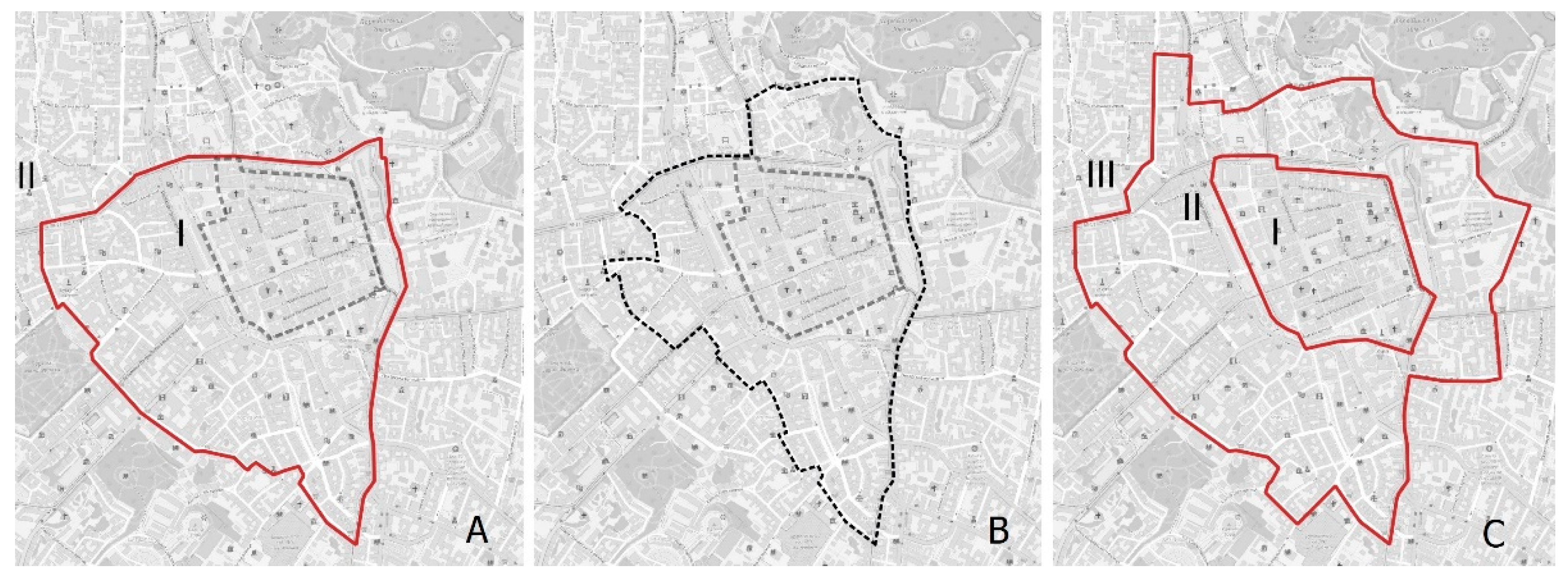
  • “Zone I” covers the historic center (the pedestrian zone);
  • “Zone II” includes streets adjacent to the historic center;
  • “Zone III” is approximately within the so-called “near the center”, with early twentieth century buildings;
  • “Zone IV” covers the rest of the city.
Parking spaces in “Parking Zone II” are of the greatest demand. According to the official data, there are 757 charged parking spaces today (see Figure 6B), which is almost twice as many as in 2016 (see Figure 6A). As of 2021, the cost of on-street parking for visitors in this area is USD 0.57 per hour, which indicates a rise in price by 380% compared to the price of USD 0.15 per hour at the beginning of 2016. Because of the big demand for parking spaces, the current price is USD 0.76 per hour, and the local government is intending to further raise the price. However, local residents have a big discount.
The 2021 “in situ” study of 46 streets in the city center was carried out by the same methodology as in 2016 in order to objectively assess changes in the structure of the parking. It was assumed for the study that one parking space occupies 6.0/2.5/3.0 m (parallel/perpendicular/at an angle of 60°) of the length of street space.
We found considerable progress over five years. The number of arranged on-street parking spaces in the area under study increased by 72% (from 516 to 886). The rise of the charged parking spaces is 86% (from 307 to 570) and that of the free-of-charge ones is 51% (from 209 to 316). It should be noted that the actual number of charged parking spaces reported on 15 streets by the LCC is always less than the number revealed in the study by situation (the method of 6.0/2.5/3.0 m). This raises the question about the legality of the “over-official” parking spaces (see Figure 10).
The possibility of increasing the number of on-street parking spaces lies in arranging parking spaces in places that do not violate traffic codes (see Figure 11). The number of such unarranged places fell by 32% (from 834 to 566)
The number of on-street parking occurrences in prohibited places has significantly fallen, by 69% (from 277 to 85), mainly because of the changes in legislation.
In 2016, chaotic parking was recorded on 18 of the 46 surveyed streets, and in 2021—on 13 of them, which shows a fall of 28%. The installation of barriers on sidewalks (columns) is the most effective tool to be used in streets where similar problems still occur (see Figure 12).
In general, the trends in the arrangement of on-street parking indicate that Lviv is in the second phase according to G. Mingardo, B. van Wee, and T. Rye—“The advent of pricing parking”, which includes the introduction of priced parking and the extension of the paid parking zone. In order to move to the third phase of the “Parking policy as integral part of TDM (Transportation Demand Management) strategies”, it is necessary to complete the previous one and arrange parking spaces in the entire of “Parking Zone II”. It is alarming that at least 36% (316 of 886) of the arranged spaces in the surveyed streets are still free of charge for parking. The experience of Cracow seems to be reasonable, in which parking within the paid parking zone is always charged and does not require the clear equipment of a specific number of paid parking spaces and their accounting and marking.
As the buildings of Lviv have a high historical value in combination with their high density and narrow streets, it is physically impossible to adapt the transport network for convenient car traffic. The intensive development of housing construction in Lviv leads to an increase in population density and city decentralization—the formation of urban subcenters in remote districts, in which the authors propose to use on-street parking on the same principle as in the center. Growing demand creates the necessity to expand the existing parking zones, which today cover only part of the historic center of the city. The authors of the article are convinced that further development of the parking network must include the expansion of parking zones with their strict rules and conditions for the territory of the whole historic center. Travel to the city center by car should be convenient but expensive. To do this, it is necessary to set high prices in the neighborhoods of greatest demand, and when implementing the IoT smart parking system, one should think about dynamic pricing. During the construction of multi-level parking lots, street parking spaces will be eliminated in favor of adapting the historic environment of the city for the comfortable movement of pedestrians, cyclists, and environmentally friendly public transportation. The small number of places, their high cost, and the ability to find a free parking place using the IoT smart parking system make it possible to balance the demand for parking lots, reduce the use of cars for city trips, and harmonize the use of different types of transportation. Simultaneously, with the development of parking zones, intercepting parking “park and ride” lots, which do not exist in Lviv now, should be constructed. They should be located at the end stations of the routes of public transportation. In the future, such a set of measures will expand the car-free zone of Lviv and will make a significant contribution to the development of the sustainable transport system in Lviv.

Author Contributions

Conceptualization, C.Z. and H.P.; methodology, H.P. and R.L.; software, C.Z. and O.K; validation, C.Z., H.P. and R.L.; formal analysis, C.Z. and O.K.; investigation, C.Z. and H.P.; resources, H.P, R.L. and O.K.; data curation, O.K.; writing—original draft preparation, C.Z. and H.P.; writing—review and editing, H.P. and O.K.; visualization, H.P. and R.L.; supervision, C.Z. and H.P.; project administration, C.Z. and O.K.; funding acquisition, C.Z. and O.K. All authors have read and agreed to the published version of the manuscript.

Funding

The study in 2016 was carried out within the project Petryshyn, H.P.; Tupis, S.P.; Sosnova, N.S.; Skliarova, I.V.; Liubytskyi, R.I. Designing the project of parking lots, parking spaces and garages, vol. 1. Description. PPVP “Arkhnovo”: Lviv, Ukraine, 2016.

Institutional Review Board Statement

Not applicable.

Informed Consent Statement

Not applicable.

Data Availability Statement

The supplementary data and all computational results can be found in the corresponding author.

Conflicts of Interest

The authors declare no conflict of interest.

References

  1. Kodransky, M.; Hermann, G. Europes Parking U-turn. From Accommodation to Regulation; Institute for Transportation and Development Policy: New York, NY, USA, 2011. [Google Scholar]
  2. Mingardo, G.; van Wee, B.; Rye, T. Urban parking policy in Europe. A conceptualization of past and possible future trends. Transp. Res. A Policy Pract. 2015, 74, 268–281. [Google Scholar] [CrossRef] [Green Version]
  3. Pojani, D.; Corcoran, J.; Sipe, N.; Mateo-Babiano, I.; Stead, D. Parking: An International Perspective; Elsevier: Amsterdam, The Netherlands, 2019. [Google Scholar]
  4. Shoup, D.C. The trouble with minimum parking requirements. Transp. Res. A Policy Pract. 1999, 33, 549–574. [Google Scholar] [CrossRef] [Green Version]
  5. Shoup, D.C. The High Cost of Free Parking; Routledge: New York, NY, USA, 2021. [Google Scholar]
  6. Barter, P. On-Street Parking Management. An International Toolkit. Sustainable Urban Transport Technical Document; Deutsche Gesellschaft für Internationale Zusam-Menarbeit (GIZ) GmbH: Eschborn, Germany, 2016; Volume 14. [Google Scholar]
  7. Ison, S.; Mulley, C. Parking. Issues and Policies. Transport and Sustainability; Emerald Publishing: Bingley, UK, 2014; Volume 5. [Google Scholar]
  8. Feeney, B.P. A review of the impact of parking policy measures on travel demand. Transp. Plan. Technol. 1989, 13, 229–244. [Google Scholar] [CrossRef]
  9. Banister, D. Transport and Urban Development, 1st ed.; E & FN Spon: London, UK; New York, NY, USA, 1995. [Google Scholar]
  10. Daniels, P.W.; Warnes, A.M. Movement in Cities. Spatial Perspectives on Urban Transport and Travel. University Paperbacks; Routledge: London, UK, 2013; Volume 809. [Google Scholar]
  11. Vuchic, V.R. Urban Transit Systems and Technology; John Wiley & Sons.: New York, NY, USA, 2007. [Google Scholar]
  12. Cervero, R. The Transit Metropolis: A Global Inquiry; Island Press: Washington, WA, USA, 1998. [Google Scholar]
  13. Dasgupta, M.; Oldfield, R.; Sharman, K.; Webster, V. Impact of Transport Policies in Five Cities; Traffic and Transport Research Centre: Texas, TX, USA, 1994. [Google Scholar]
  14. Pucher, J.R.; Lefèvre, C. The Urban Transport Crisis in Europe and North America; Macmillan: Basingstoke, UK, 1996. [Google Scholar]
  15. Vuchic, V. Transportation for Livable Cities, 1st ed.; Routledge: London, UK, 2017. [Google Scholar]
  16. Petryshyn, H.P.; Liubytskyi, R.I. Significance of “Project of detailed planning of the city center in Lviv” issued in 1970 in forming modern city. In Andrii Rudnytskyi: Architecture Portrait of the Epoch; Cherkes, B., Dyda, I., Eds.; Lviv Polytechnic National University: Lviv, Ukraine, 2019; pp. 57–69. [Google Scholar]
  17. Petryshyn, H.; Liubytskyi, R. Ignacy Drexlers vision of planning development of the city of Lviv. Przestrz. I Forma. 2018, 33, 173–194. [Google Scholar]
  18. Tupis, S.P.; Liubytskyi, R.I. Urban planning and administrative problems of parking in the center of Lviv. Her. Lviv. Polytech. Natl. Univ. Ser. Archit. 2016, 856, 145–154. [Google Scholar]
  19. Liubytskyi, R.I. Designign the Network of the Parking Objects for Personal Automobile Transportation in Historical Cities (The case study of Lviv). Ph.D. Thesis, Lviv Polytechnic National University, Lviv, Ukraine, 2018. [Google Scholar]
  20. Petryshyn, H.P.; Tupis, S.P.; Sosnova, N.S.; Skliarova, I.V.; Liubytskyi, R.I. Designing the Project of Parking Lots, Parking Spaces and Garages; Description. PPVP “Arkhnovo”: Lviv, Ukraine, 2016; Volume 1. [Google Scholar]
  21. Liubytskyi, R.I. “On-street parking” in historical city. Modern problems of architecture and urban planning. Sci. Tech. J. KNUBA 2016, 45, 253–263. [Google Scholar]
  22. Liubytskyi, R.I. Influence of unorganized parking on operation of the structure of a city. Archit. Her. KNUBA 2017, 13, 127–138. [Google Scholar]
  23. Cherkes, B.; Petryshyn, H.; Konyk, S. Urbanizational trends and impulses in the housing consruction of Ukraine. IOP Conf. Ser. Mater. Sci. Eng. 2019, 471, 092058. [Google Scholar] [CrossRef]
  24. Dubyna, V.I.; Krupa, P.I.; Krupa, I.P.; Pona, O.S.; Mariev, O.P. DP DIPM "Mistoproekt", Architecture-Planning Wirkshop No. Corrections of the General Plan of Lviv. Archive DP DIPM "Mistoproekt", Inv. No. P-16; Lviv Branch of "Giprograd": Lviv, Ukraine, 2008. [Google Scholar]
  25. Mobility Lviv: The Mobility Survey. The Cold Period of the Year. Available online: http://city-institute.org/content/uploads/2021/07/prezz_mob-2021-eng.pdf (accessed on 11 February 2022).
  26. Mobility Lviv: About the Project. Available online: https://mobilitylviv.com/en/about-the-project-eng/ (accessed on 20 February 2022).
  27. Zantke, G. Solution of traffic problems in the central area of Lviv. Arch. St. 2015, 1, 99–106. [Google Scholar]
  28. Liubytskyi, R.I. Rise of the amount of cars as an appearance of anthropogenic load on environment of historical cities. Urban and landscape planning. Sci. Tech. J. KNUBA 2017, 64, 183–192. [Google Scholar]
  29. Miejska Infrastruktura Sp. z o.o.: Biuro Strefy Płatnego Parkowania. Available online: http://mi.krakow.pl/strefa-platnego-parkowania/informacje-ogolne (accessed on 19 February 2022).
  30. Greengard, S. The Internet of Things; MIT Press: Cambridge, MA, USA, 2015. [Google Scholar]
  31. Xu, H.; Przystupa, K.; Fang, C.; Marciniak, A.; Kochan, O.; Beshley, M. A combination strategy of feature selection based on an integrated optimization algorithm and weighted k-nearest neighbor to improve the performance of network intrusion detection. Electronics 2020, 9, 1206. [Google Scholar] [CrossRef]
  32. Kochan, R.; Kochan, O.; Chyrka, M.; Vasylkiv, N. Precision Data Acquisition (DAQ) Module with Remote Reprogramming. In Proceedings of the Third Workshop-2005 IEEE Intelligent Data Acquisition and Advanced Computing Systems: Technology and Applications, IDAACS 2005, Sofia, Bulgaria, 5–7 September 2005; pp. 279–282. [Google Scholar]
  33. What Is the Internet of Things (IoT)? Available online: https://www.techtarget.com/iotagenda/definition/Internet-of-Things-IoT (accessed on 29 May 2022).
  34. Jun, S.; Kochan, O.; Kochan, R. Thermocouples with built-in self-testing. Int. J. Thermophys. 2016, 37, 1–9. [Google Scholar] [CrossRef]
  35. Kochan, R.; Kochan, O.; Chyrka, M.; Jun, S.; Bykovyy, P. Approaches of Voltage Divider Development for Metrology Verification of ADC. In Proceedings of the 2013 IEEE 7th International Conference on Intelligent Data Acquisition and Advanced Computing Systems (IDAACS), Berlin, Germany, 12–14 September 2013. [Google Scholar]
  36. Hu, Z.; Khokhlachova, Y.; Sydorenko, V.; Opirskyy, I. Method for optimization of information security systems behavior under conditions of influences. Int. J. Intell. Syst. Appl. 2017, 9, 46–58. [Google Scholar] [CrossRef] [Green Version]
  37. Hu, Z.; Dychka, I.; Onai, M.; Zhykin, Y. Blind payment protocol for payment channel networks. Int. J. Comput. Netw. Inf. Secur. 2019, 11, 22–28. [Google Scholar] [CrossRef]
  38. Song, W.; Beshley, M.; Przystupa, K.; Beshley, H.; Kochan, O.; Pryslupskyi, A.; Pineniak, D.; Su, J. A software deep packet inspection system for network traffic analysis and anomaly detection. Sensors 2020, 20, 1637. [Google Scholar] [CrossRef] [Green Version]
  39. Demand-Responsive Parking Pricing. Available online: https://www.sfmta.com/demand-responsive-parking-pricing (accessed on 29 May 2022).
  40. The Internet of Things in Public Transport. Available online: https://cms.uitp.org/wp/wp-content/uploads/2021/01/IOT-KB-final.pdf (accessed on 29 May 2022).
  41. Biyik, C.; Allam, Z.; Pieri, G.; Moroni, D.; O’Fraifer, M.; O’Connell, E.; Olariu, S.; Khalid, M. Smart parking systems: Reviewing the literature, architecture and ways forward. Smart Cities 2021, 4, 623–642. [Google Scholar] [CrossRef]
  42. You, I.; Kwon, S.; Choudhary, G.; Sharma, V.; Seo, J.T. An Enhanced LoRaWAN security protocol for privacy preservation in IoT with a case study on a smart factory-enabled parking system. Sensors 2018, 18, 1888. [Google Scholar] [CrossRef] [Green Version]
  43. Zhu, Y.; Ye, X.; Chen, J.; Yan, X.; Wang, T. Impact of cruising for parking on travel time of traffic flow. Sustainability 2020, 12, 3079. [Google Scholar] [CrossRef] [Green Version]
  44. Cherkes, B.; Fedak, A.; Shtendera, A. The current features of the central public space functioning in the historical city, a UNESCO world heritage site. IOP Conf. Ser. Mater. Sci. Eng. 2019, 603, 032006. [Google Scholar] [CrossRef]
  45. Novakovskii, Y.A.A.; Petrova, A.A.; Mih, R.M.; Novakovskii, A.Y.A.; Rudnickii, A.M. Lviv Branch of "Giprograd", Arhitecture-planning Workshop No.2: Project of Detailed Planning of the City Center in Lviv. Archive DP DIPM "Mistoproekt", Inv. No. P-213; Lviv Branch of "Giprograd": Lviv, Ukraine, 1970. [Google Scholar]
  46. Chetverta Studiia: The Annual Rise of the Amount of Cars in Lviv Is 10%. Available online: https://4studio.com.ua/novyny/u-lvovi-kilkist-avtomobiliv-kozhnogo-roku-zbilshuyetsya-na-10-foto-video/ (accessed on 19 February 2022).
  47. EasyWay: Routes of the Public Transportation in Lviv. Available online: https://www.eway.in.ua/ua/cities/lviv/routes (accessed on 18 February 2022).
  48. From Cars to Public Transport: The Transport Strategy Access in Lviv is Changed. Available online: https://cutt.ly/dGvOOVO (accessed on 26 April 2022).
  49. There Was Accepted the Concept for Developing of Electrical Mobility. Available online: https://tvoemisto.tv/news/u_lvovi_zatverdyly_kontseptsiyu_rozvytku_elektromobilnosti_90748.html (accessed on 26 April 2022).
  50. Population of Cities in Ukraine. Available online: https://index.minfin.com.ua/ua/reference/people/town/ (accessed on 25 April 2022).
  51. Lviv City Council: Parking in the City. Available online: https://web.archive.org/web/20160410060158/https://city-adm.lviv.ua/portal/transport/parking (accessed on 11 February 2021).
  52. Lviv City Council: Parkuvannia u Misti. Available online: https://city-adm.lviv.ua/portal/transport (accessed on 11 February 2022).
  53. Lviv City Council: Parking in the City. Available online: https://web.archive.org/web/20180512071358/http://city-adm.lviv.ua/portal/transport/parking (accessed on 15 February 2022).
  54. Hotel «Rius»: Parkuvannia-Hotel RIUS Lviv. Available online: http://www.rius-hotel.lviv.ua/ua/services/parking/ (accessed on 11 February 2022).
  55. Forum Lviv: Forum Lviv-Parkovka. Available online: http://lviv.multi.eu/ua/parkovka/ (accessed on 11 February 2022).
  56. ZAXID.NET: Miskrada Ostatochno Zatverdyla Pidvyshcheni Taryfy na Parkuvannia v Tsentri Lvova. Available online: https://zaxid.net/miskrada_ostatochno_zatverdila_pidvish-heni_tarifi_na_parkuvannya_v_tsentri_lvova_n1403737 (accessed on 11 February 2022).
  57. ZAXID.NET: Vartist Parkuvannia v Tsentri Lvova Zrosla Maizhe Vtrychi. Available online: https://zaxid.net/vartist_parkuvannya_v_tsentri_lvova_zrosla_do_15_20_griven_za_mayzhe_vtrichi_n1444745 (accessed on 11 February 2022).
  58. Cabinet of Ministrers of Ukraine: On the Traffic Codes, No. 1306 (Decision No. 1306). Available online: http://zakon2.rada.gov.ua/laws/show/1306-2001-p/page (accessed on 11 February 2022).
  59. Verkhovna Rada Ukrainy: Pro Dorozhnii Rukh, No. 3353-XII (Zakon Ukrainy No. 3353-XII). Available online: http://zakon5.rada.gov.ua/laws/show/3353-12/page?text=%EF%E0%F0%EA%F3 (accessed on 11 February 2022).
  60. Lviv City Council: On Changing the Decisions of the Executive Committee from 05.12.2014 No. 929, No. 493 (Decision No. 493). Available online: http://www8.city-adm.lviv.ua/Pool/Info/doclmr_1.NSF/6fe2c915759101d6422566a0003bb602/f68e2215ce662274c2257fdc004bc876?OpenDocument (accessed on 11 February 2022).
  61. On Approvement of the Order of Formation of Tariffs for Services on the Use of Sites for a Fee of Charge Vehicle Parking. Available online: https://zakon.rada.gov.ua/laws/show/258-2010-п#Text (accessed on 13 May 2022).
  62. Parking in Lviv for 30 Hryvnias per Hour. Available online: https://wz.lviv.ua/news/405659-parkuvannia-v-tsentri-lvova-30-hryven-za-hodynu (accessed on 13 May 2022).
  63. Where Can I park. Available online: https://lviv.nashigroshi.org/2020/08/07/a-de-ya-mayu-staty/ (accessed on 29 May 2022).
  64. How to Park in Lviv and Do Not Pay a Fine? Available online: https://radiopershe.com/news/yak-parkuvatys-u-lvovi-ne-platyty-shtrafy (accessed on 29 May 2022).
  65. Almost 50% of Drivers Try to Avoid Paying for Parking–Director of Lvivatodor. Available online: https://suspilne.media/164332-majze-50-vodiiv-namagautsa-uniknuti-oplati-za-parkuvanna-direktor-lvivavtodoru/ (accessed on 29 May 2022).
  66. Liubytskyi, R. Urban planning concepts of the underground tram network creation in Lviv in the 70–80s of the 20th century. Bull. Lviv. Polytech. Natl. University. Ser. Arkhitektura. 2018, 893, 159–166. [Google Scholar]
  67. Posatskyi, B.; Mazur, T.; Korol, E. Development of the tram network in the big city (on the example of Lviv). IOP Conf. Ser. Mater. Sci. Eng. 2020, 907, 012063. [Google Scholar] [CrossRef]
  68. The Master Plan of Lviv. Available online: https://drive.google.com/drive/u/0/folders/14z0dQ6_ZSvKpFcwPEUWZ8ES7Cwez1nV9] (accessed on 13 May 2022).
  69. Sosnova, N.S. Theoretic and Methodological Bases of Formation of Public Spaces of Ukrainian Cities. Ph.D. Thesis, Lviv Polytechnic National University, Lviv, Ukraine, 2021. Available online: https://lpnu.ua/sites/default/files/2021/dissertation/10294/disertaciya-sosnova-2.pdf (accessed on 13 May 2022).
  70. Road Traffic: Smarter Parking. Available online: https://new.siemens.com/global/en/company/stories/mobility/smarter-parking.html (accessed on 29 May 2022).
Figure 1. The ratio of users of different modes of transport in Lviv in the cold period of the year (2019—orange and 2021—black). Source: http://city-institute.org/content/uploads/2021/07/prezz_mob-2021-eng.pdf [25]. (accessed on 16 May 2022).
Buildings 12 00865 g001
Figure 2. Scheme of expansion of parking zones in the center of Lviv: (A) parking zones and the pedestrian area in 2016 [51]; (B) proposal for a short-term entry zone (2016) within which the study was conducted [20]; (C) parking zones in 2021 [52]. Schemes by R. Liubytskyi.
Buildings 12 00865 g002
Figure 3. Scheme of on-street parking status in 2016 (“in situ”). Scheme by R. Liubytskyi.
Buildings 12 00865 g003
Figure 4. On-street parking in the pedestrian zone in 2016. Parking in permitted places is depicted in blue, and the prohibited places are in red. The scheme by R. Liubytskyi.
Buildings 12 00865 g004
Figure 5. Typical on-street parking situations in the central part of Lviv in 2016: (A) parking on part of the sidewalk; (B) double parking; (C) parking under the prohibition sign; (D) parking on the entire sidewalk. Photo by R. Liubytskyi.
Buildings 12 00865 g005
Figure 6. The charged on-street parking spaces in 2016 (A) and 2021 (B), based on Lviv City Council data [51,52]. Schemes by R. Liubytskyi.
Buildings 12 00865 g006
Figure 7. The scheme of on-street parking status in 2021 (“in situ”). Scheme by R. Liubytskyi.
Buildings 12 00865 g007
Figure 8. Comparative analysis of changes in on-street parking conditions, based on Table 2 and Table 3 (2016—green and 2021—black).
Buildings 12 00865 g008
Figure 9. Comparative analysis of changes in on-street parking—field survey (2016 and 2021).
Buildings 12 00865 g009
Figure 10. According to the official data on Sichovykh Striltsiv Street there are only 12 on-street parking places (LCC website [52]). Photo by R. Liubytskyi.
Buildings 12 00865 g010
Figure 11. (A) On-street parking on Stetska Street. Non-arranged parking, but without violation of traffic rules (2016). (B) Paid on-street parking in the same place (2021). Photo by R. Liubytskyi.
Buildings 12 00865 g011
Figure 12. (A) Parked sidewalk, which blocks pedestrian movement on Furmanska Street (2016). (B) Parking barriers (columns) protect the sidewalk from the former chaotic parking (2021). Photo by R. Liubytskyi.
Buildings 12 00865 g012
Figure 13. The directions of territorial development of the city center according to the master plan of Lviv for the period of 2010–2025. The scheme was prepared by the authors using the master plan [68].
Buildings 12 00865 g013
Figure 14. The population density diagram in Lviv with modern parking zones (it was constructed after processing the OpenStreetMap data according to [69].
Buildings 12 00865 g014
Figure 15. The suggested plan for developing parking zones based on demand. The scheme by H. Petryshyn and R. Liubytskyi.
Buildings 12 00865 g015
Table 1. Comparative analysis of the street and public transport network parameters [19].
City,
Population, and Area
Street Network Length, km Street Network Length per 1 Inhabitant, m Street Network Density, km/km2 High-Capacity Public Transport Network Length, km High-Capacity Public Transport Network Density, km/km2
Lviv
758,500
inhabitants
150.09 km2
1360.851.799.0734
(tram)
0.23
Cracow
744,250
inhabitants
326.85 km2
2666.513.588.16171
(tram and urban rail)
0.52
Leipzig
575,000
inhabitants
297.36 km2
2314.474.027.78212
(tram and urban rail)
0.71
Table 2. Results of the on-street parking field survey in the city center, 2016.
No. Street A B C D E F
1Bankivs’ka--16--25
2Chaykovskoho3721 (21)---21
3Chornomorska--18--17
4Doroshenka-----0
5Dudaieva----160
6Fredra--21-1118
7Furmanska-414+-21
8Hertsena-111-2711
9Hnatyuka2443 (35)14-3549
10Honty--21+-16
11Hrushevs’ koho
(+ beginning of Drahomanova)
--40+730
12Hryhorovycha--37--17
13Knyazya Leva--32--22
14Knyazya Romana-41 (37)42-2568
15Kopernika15225-922
16Kostyushka2245 (45)8+ 43
17Kovzhuna-1119- 27
18Kryvonosa----50
19Kurbasa-8-+-8
20Lista-10-+-10
21Mosyazhna--5--4
22Mykhal’chuka--18+-16
23Mukachivska---+-0
24Nalyvayka--29+1019
25Nasypna--23--17
26Nyzhankivskoho-634-2938
27Pisha--8--0
28Popovycha-48+-12
29Rudanskoho--16--8
30Rybna---+-6
31Saksahanskoho-545-2939
32Shevchenka80112 (112)33-22110
33Shukhevycha-23-+-20
34Sichovykh Striltsiv1257 (57)---54
35Snizhna---+-0
36Soborna--20--19
37Staryy Rynok--43--33
38Stetska--28+-27
39Tyktora--20+-17
40Uzhhorodska-1521+-32
41Vicheva--9+-11
42Voloshyna-819+-17
43Voronoho-719--14
44Vynnychenka-73119-52182
45Zamkova--11--11
46Zvenyhorods’ka--8--4
Total138516 (307)834182771135
A—official LCC data—paid parking places [51] (whole street/within the study border); B—field survey—arranged (paid in brackets); C—field survey—non-arranged; D—field survey—chaotic; E—field survey—with violation; F—project quantity proposal of 2016 [51].
Table 3. Results of the on-street parking field survey in the city center, 2021.
No.StreetABCDEFGHIJ
1Bankivs’ka-----1625−250-
2Vynnychenka1912627104--182−29808
3Vicheva---13--11−110-
4Voloshyna14-184--171104
5Voronoho-7-15+-14−70-
6Hertsena19-27---1116268
7Hnatyuka24730 +1949−12−66
8Honty---37+-16−160-
9Hryhorovycha13-37---17203724
10Hrushevs’koho (with the beginning of Drahomanova)21 (30)-3210-23023211
11Doroshenka------000-
12Dudaieva2594---01313N/A
13Zamkova-11----11011-
14Zvenyhorods’ka-7-8--437-
15Knyazya Leva---47--22−220-
16Knyazya Romana151522-+668−31−47
17Kovzhuna20-30---2731910
18Kopernika1523---182211N/A
19Kostyushka22-398+-43−4−617
20Kryvonosa------000-
21Kurbasa-8--+-800-
22Lista-10----1000-
23Mykhal’chuka---18+-16−160-
24Mosyazhna---7--4−40-
25Muykachivska-----4000-
26Nalyvayka21-32-+-19133211
27Nasypna---29--17−170-
28Nyzhankivskoho-13-47+838−257-
29Pisha---8--000-
30Popovycha-4-8+-12−80-
31Rybna---8+-6−60-
32Rudanskoho------8−80-
33Saksahanskoho2110315-63923610
34Sichovykh Striltsiv12-57---543045
35Snizhna-------00-
36Soborna---20--19−190-
37Staryy Rynok---45--33−330-
38Stetska17-30---2733013
39Tyktora---20--17−170-
40Uzhhorodska-15-26+-32−170-
41Fredra14821---1811297
42Furmanska-4-25--21−170-
43Chaykovskoho37-21---2100N/A
44Chornomorska---18--17−170-
45Shevchenka801611236-6110181632
46Shukhevycha-23--+-2030-
Total33231657056613851135−249370213
A—official LCC data—paid parking places [52] (whole street/within the study border); B—field survey—arranged (free); C—field survey—arranged (paid); D—field survey—non-arranged; E—field survey—chaotic; F—field survey—with violation; G—project quantity proposal of 2016 [20]; H—difference between the project quantity of 2016 and the 2021 fact; I—increase in actual parking places from 2016–2021; J—difference between actual and official paid parking spaces.
Table 4. Absolute and relative cost of parking in the study area for visitors and residents (1 parking space during the working day).
Average Wage in the Lviv Region per Month
(2021)
Parking Price for a Visitor Parking Price for a Local Resident Who Uses a Half-Year Subscription
8 h Working Dayfor One Month (8 h Working Day)Ratio of Parking Price (on Working Days) to Average Wage 8 h Working Dayfor One Month (8 h Working Day)Ratio of Parking Price (on Working Days) to Average Wage
USD 492USD 0.76 × 8 h = USD 6.120.8 days × USD 6.1 = USD 126.5126.5 USD/492.0 = 0.257 (25.7%)53.23 USD/(6 months × 20.8 working days) = USD 0.4353.23 USD/6 months = USD 8.98.9 USD/492 USD = 0.018 (1.8%)
Publisher’s Note: MDPI stays neutral with regard to jurisdictional claims in published maps and institutional affiliations.

