
The Current State of Research on Secondary Quartzites of the Northern Segment of the Jungar-Balkhash Folded System and Their Au Mineralization (Central Kazakhstan)
 ,
,
Abstract
:1. Introduction
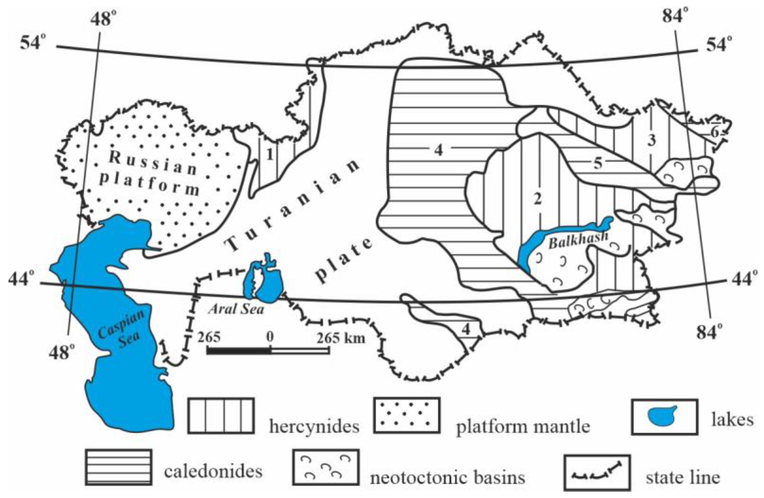
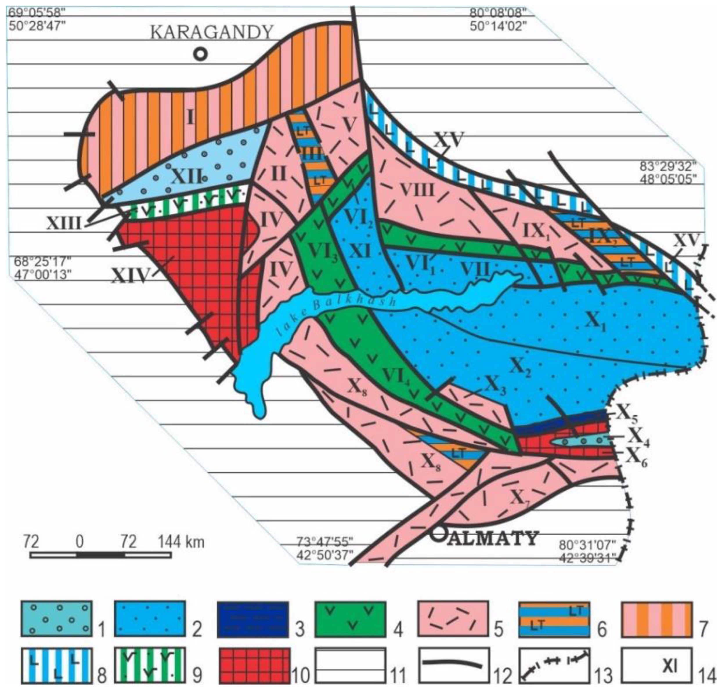
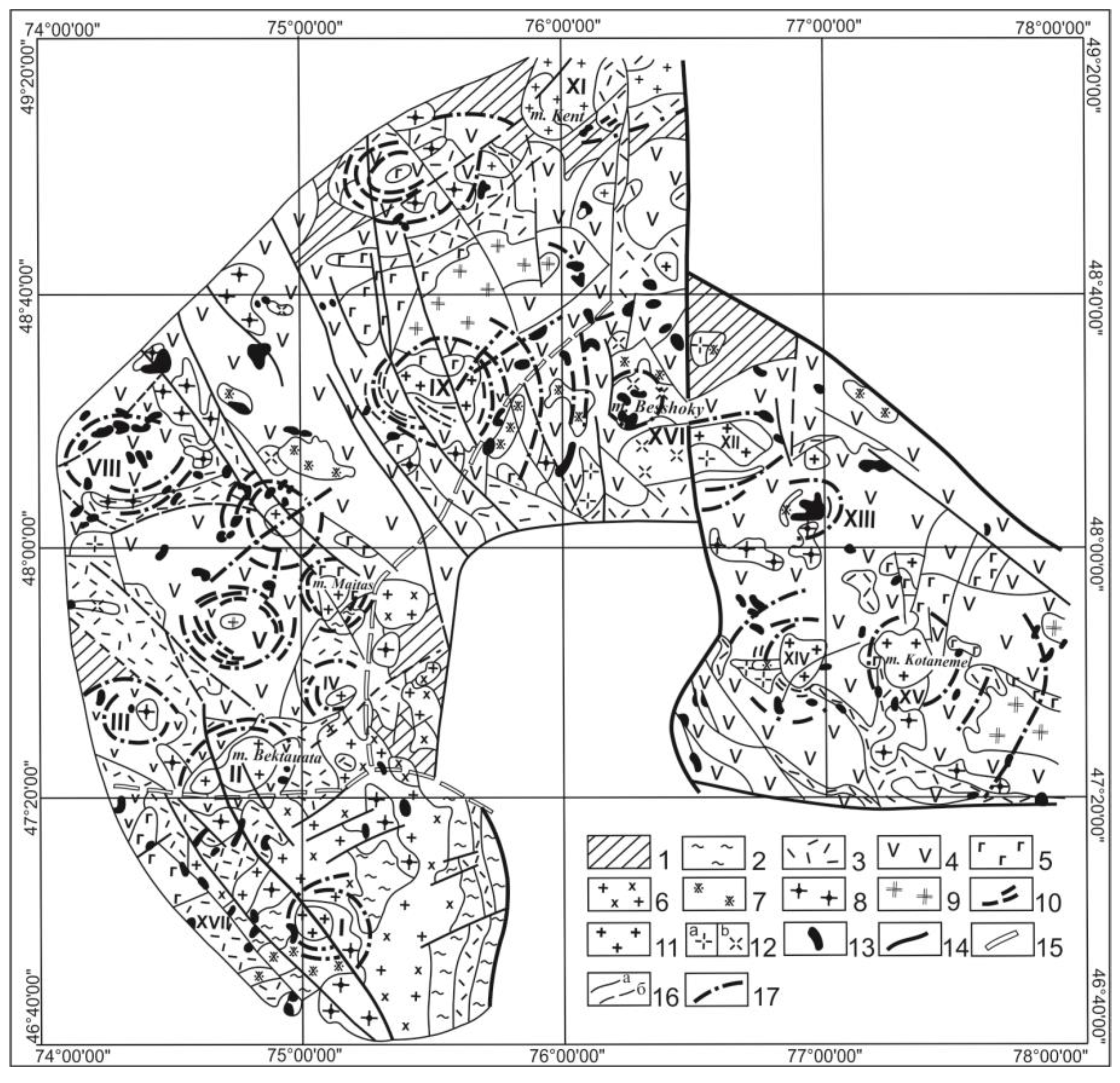
2. Materials and Methods
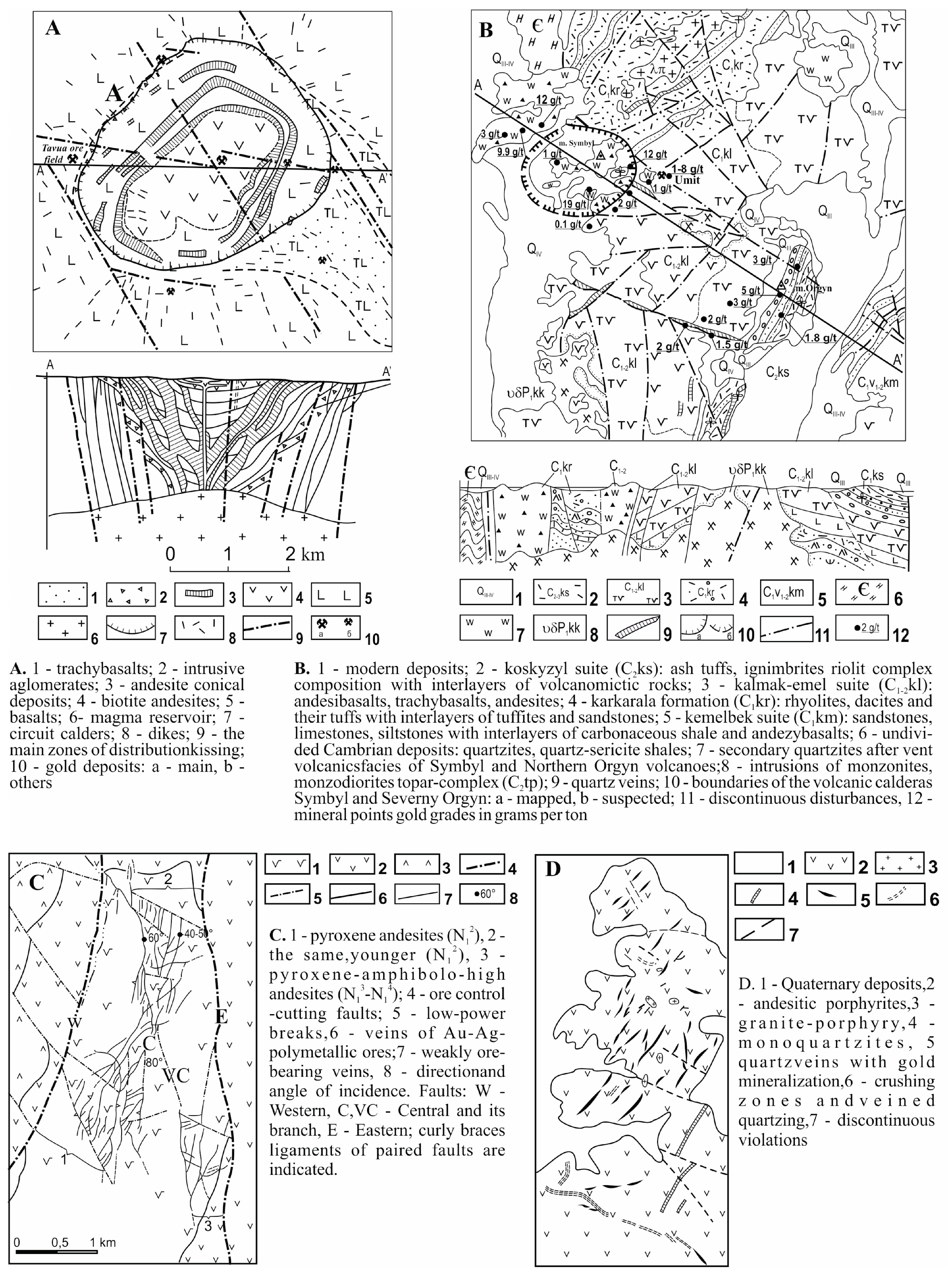
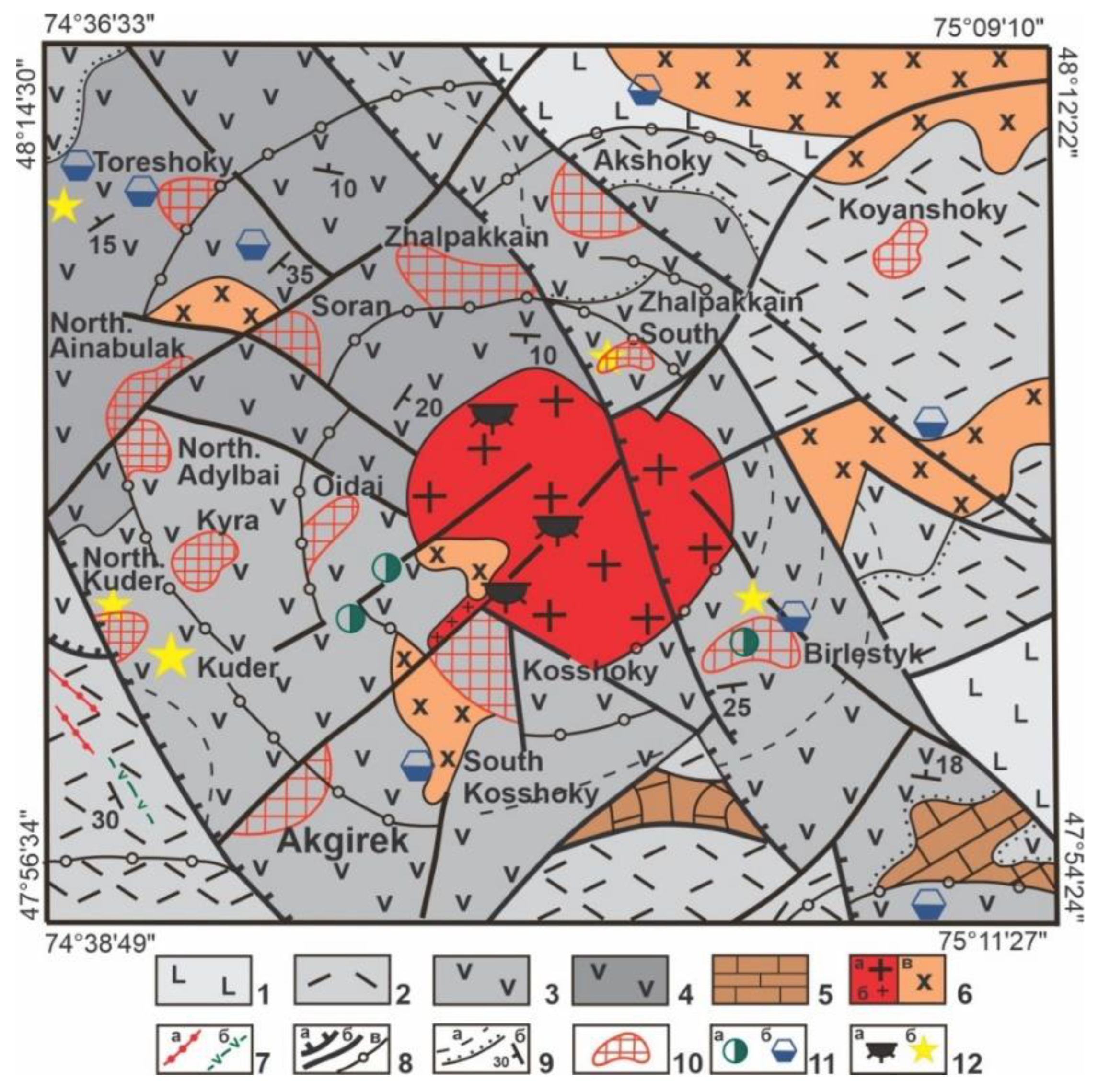
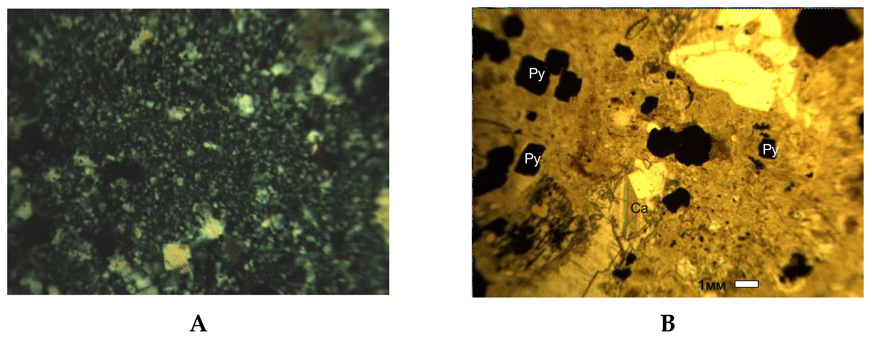
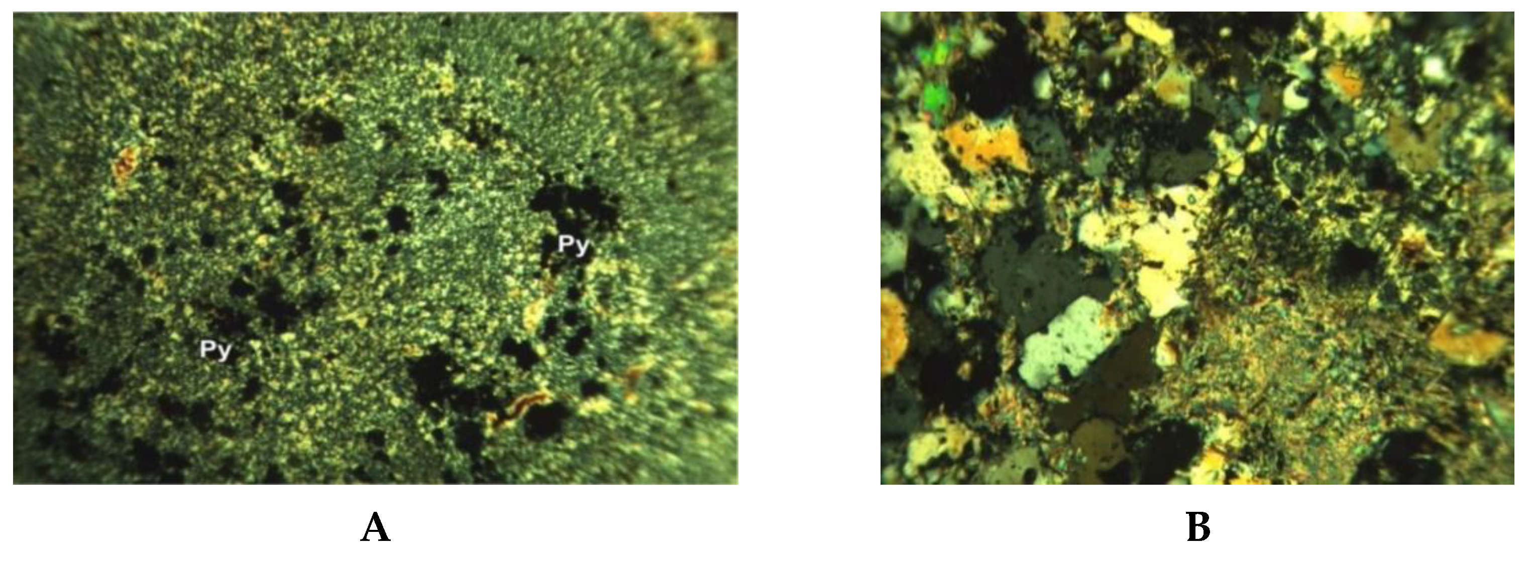
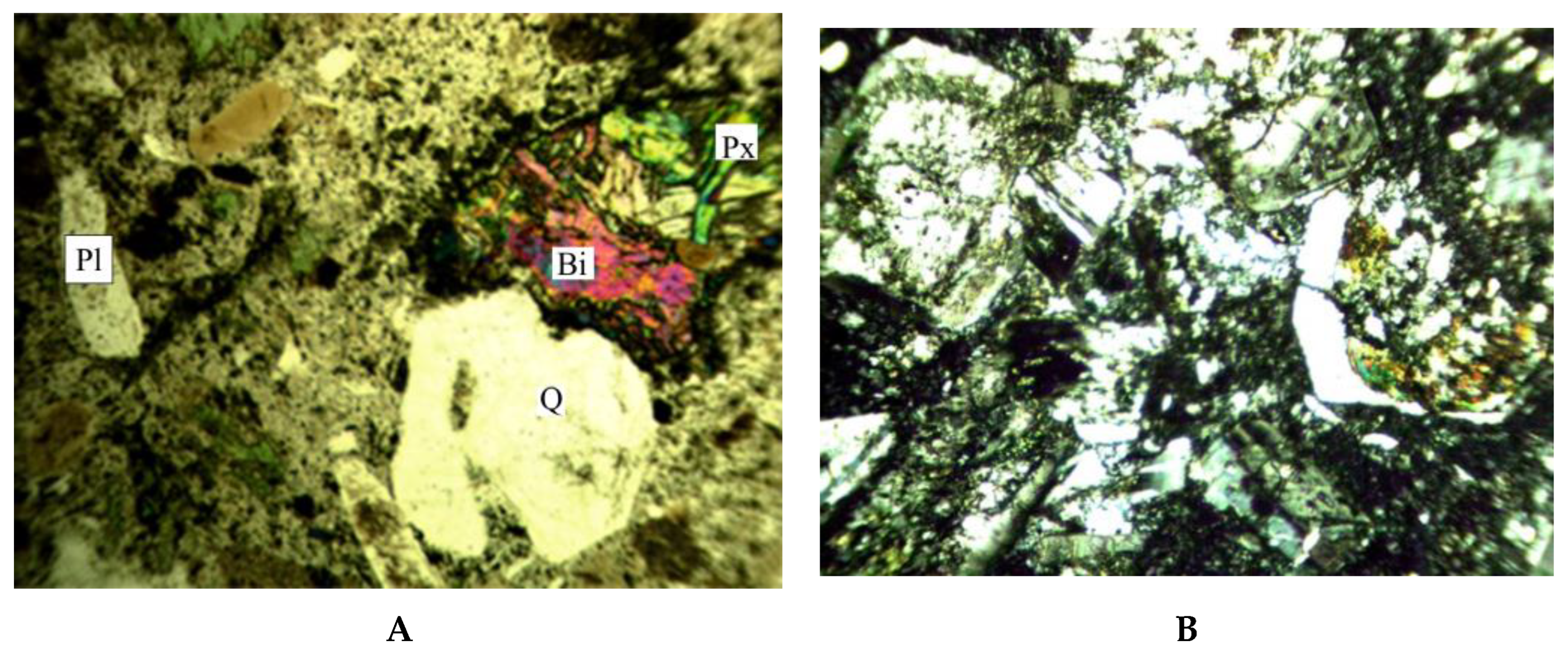
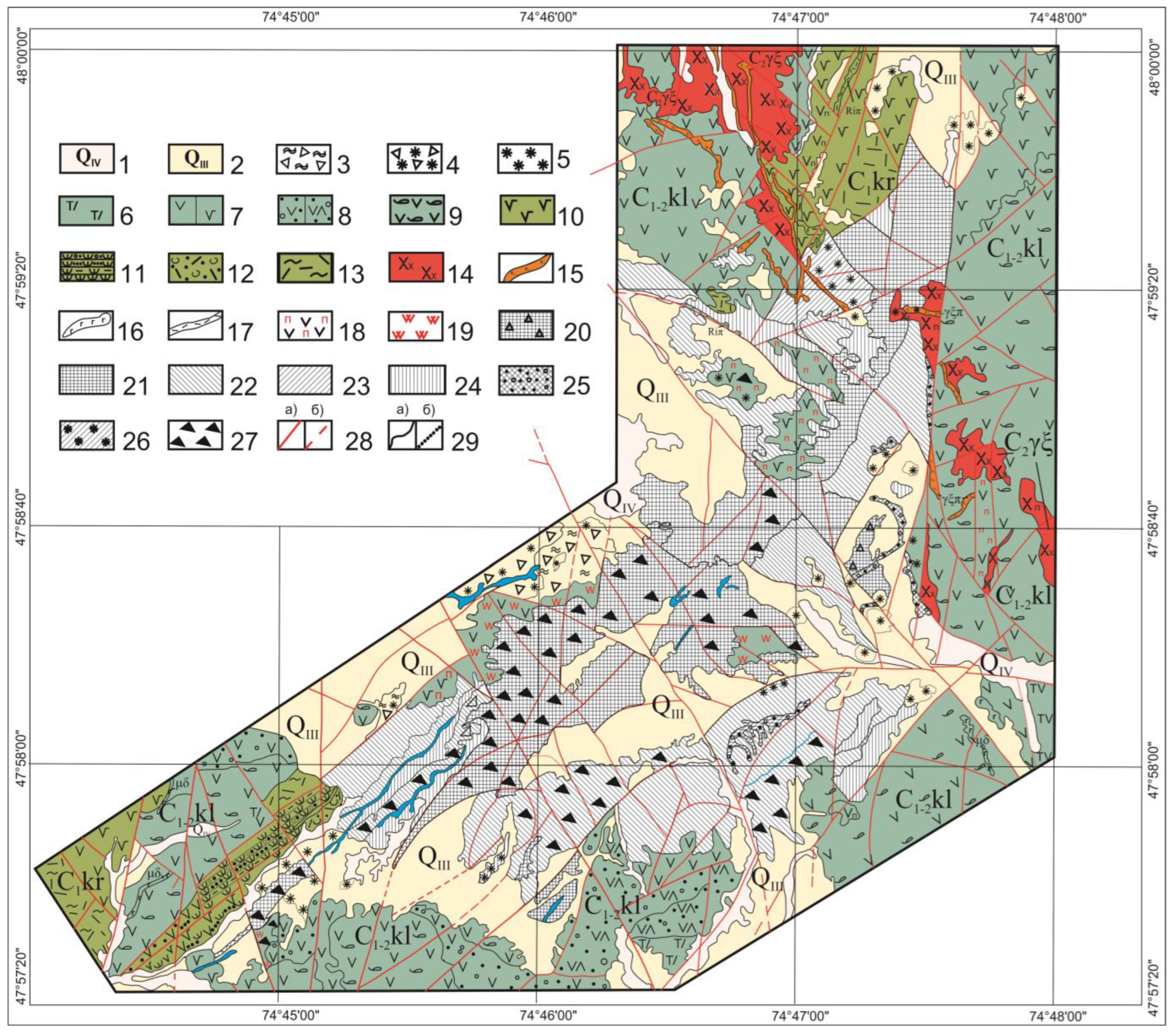
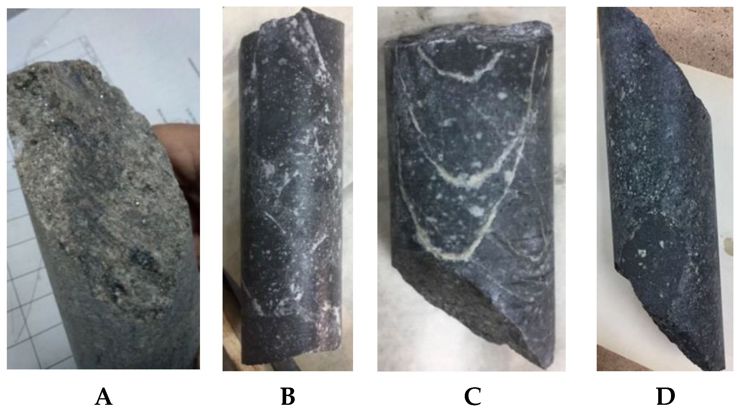
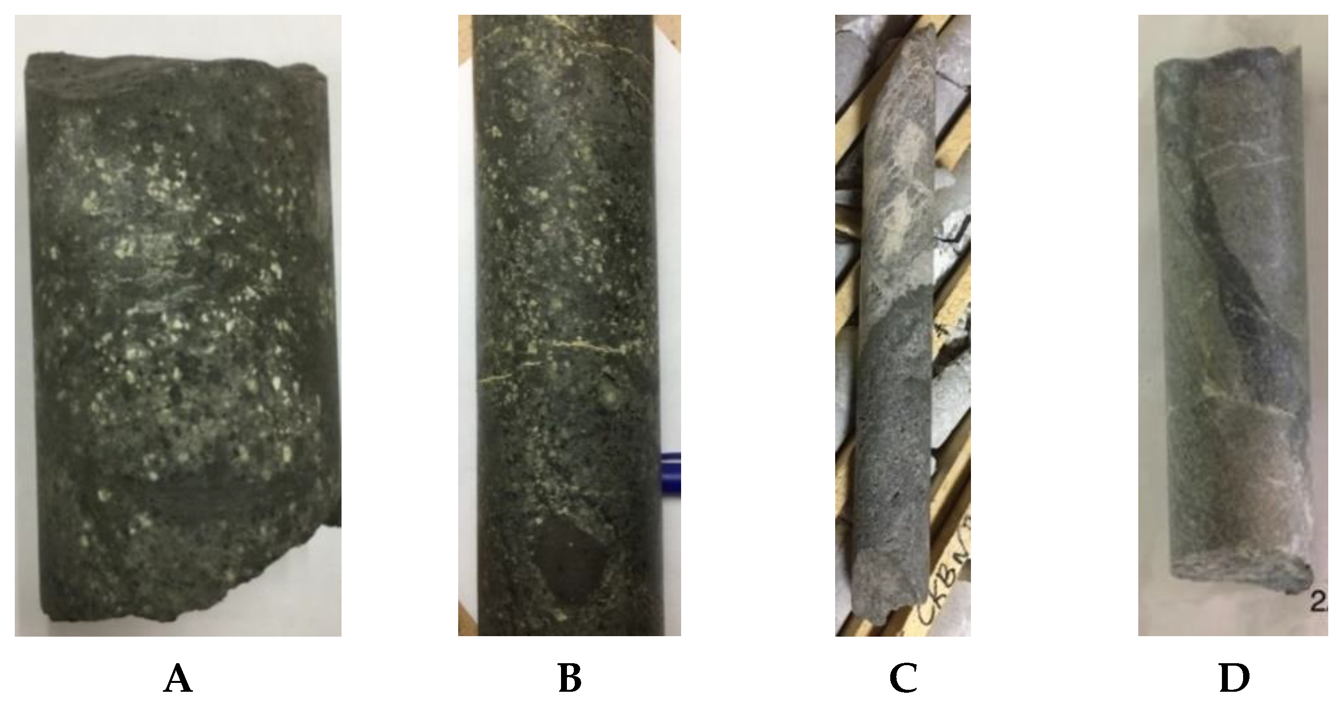
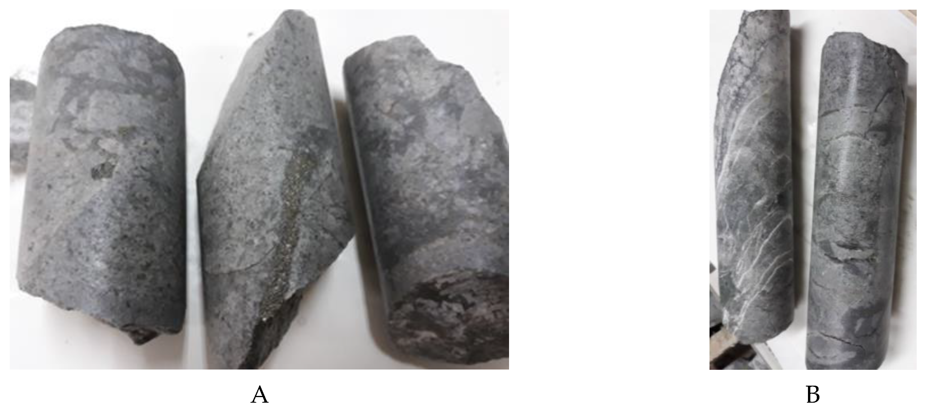
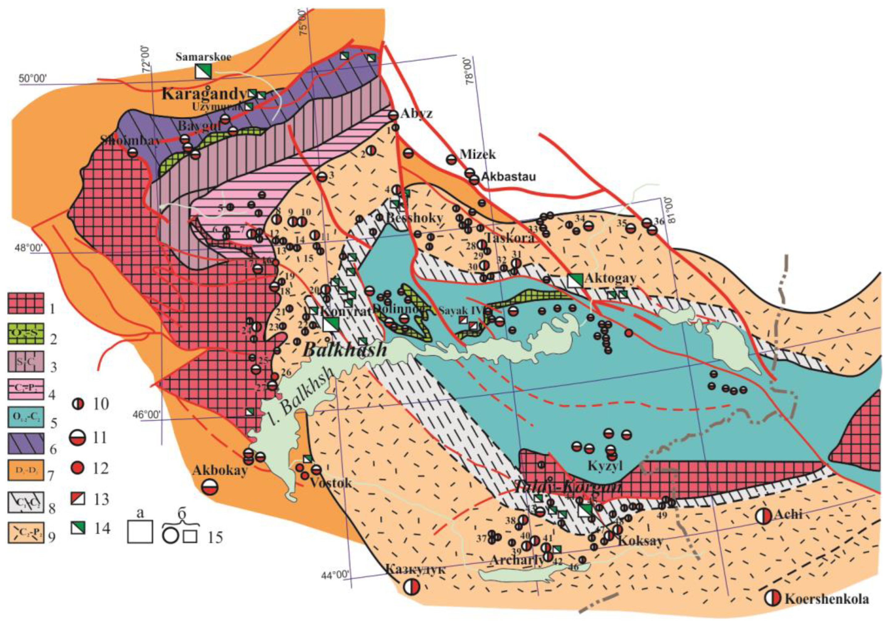
3. The Formations of the Kyzyltass Volcanic-Plutonic Structure Caused by Hydrothermal-Metasomatic Processes
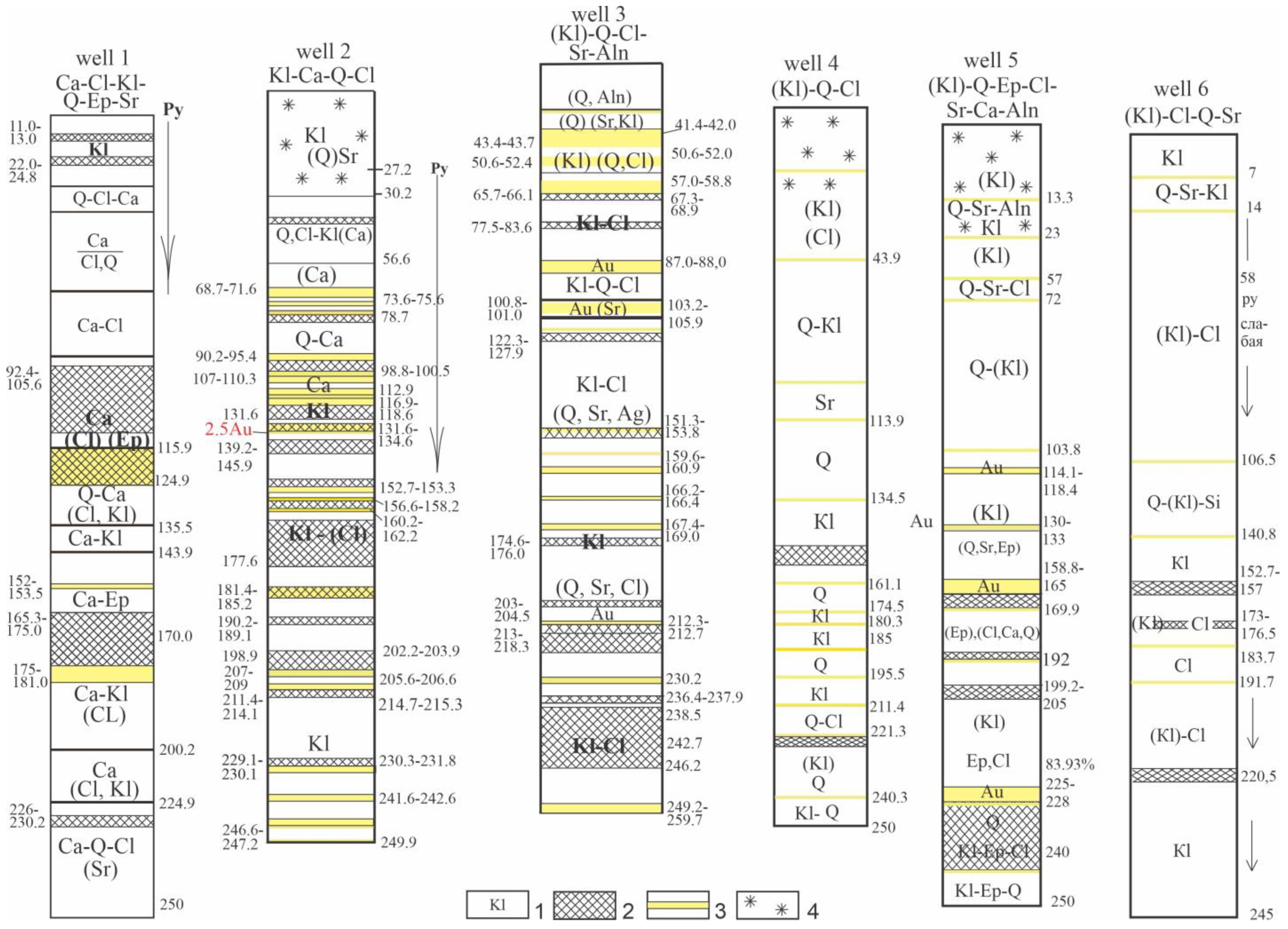
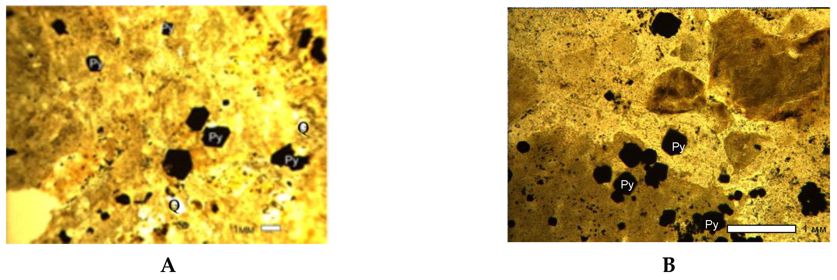
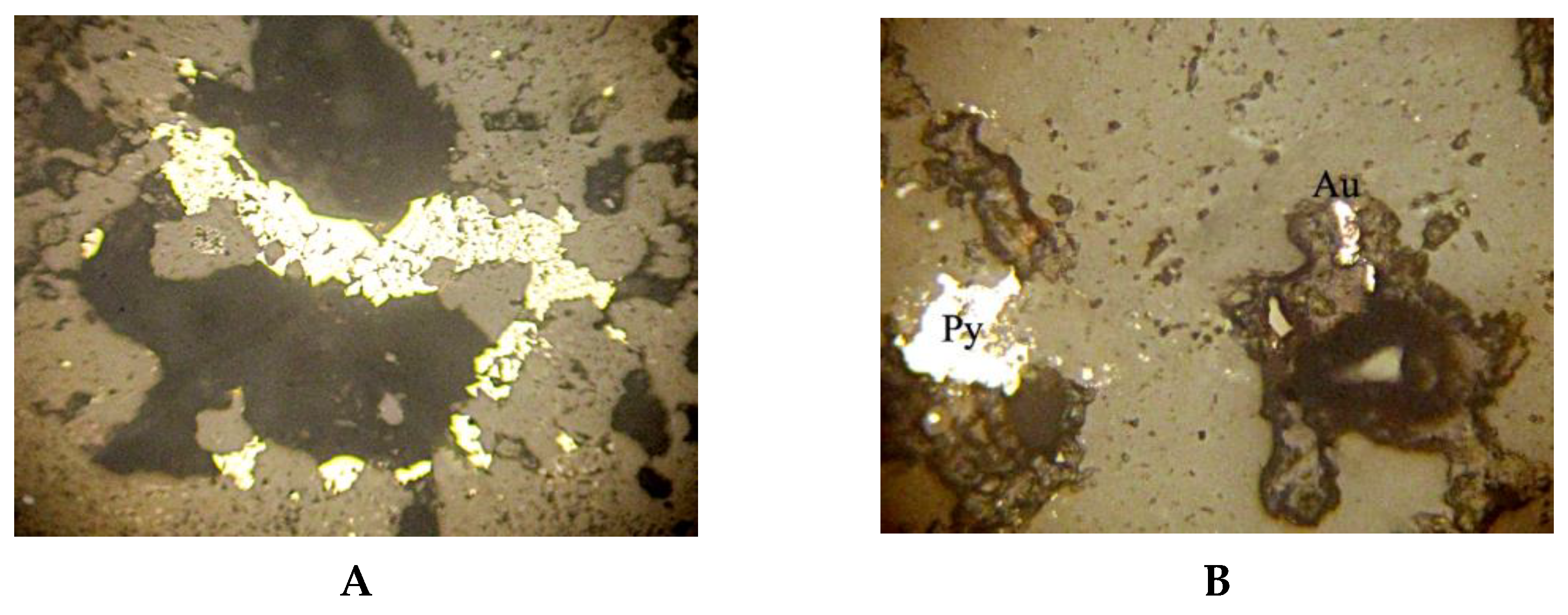
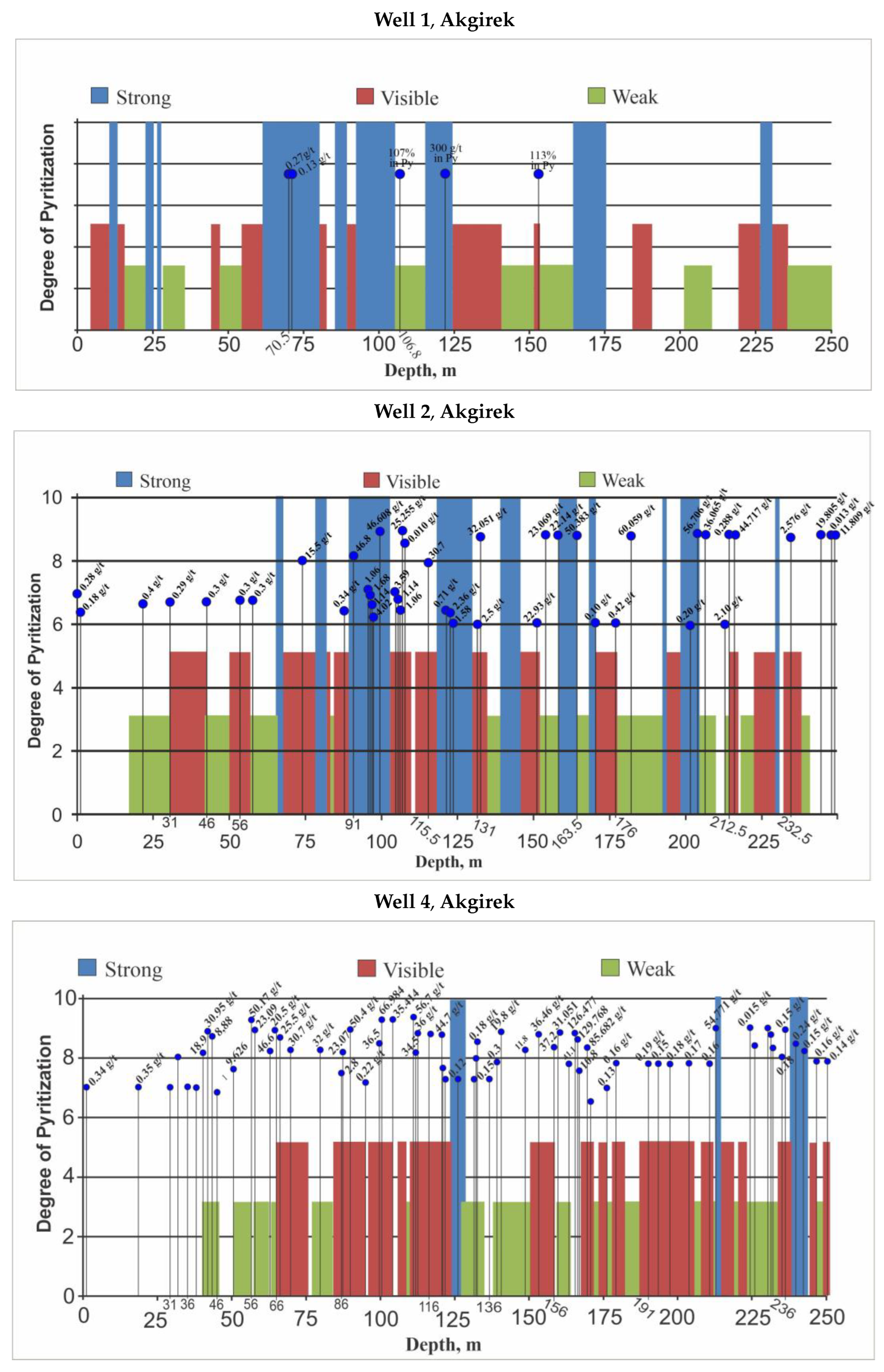
4. Results and Discussion
5. Conclusions
Author Contributions
Funding
Data Availability Statement
Conflicts of Interest
References
- Rafailovich, M.S. Gold of the Bowels of Kazakhstan: Geology, Metallogeny, Predictive and Search Models; Book Print: Almaty, Kazakhstan, 2009; 304p. [Google Scholar]
- Konstantinov, M.M. Gold and Silver Mineralization of the Volcanogenic Belts of the World; Nedra: Moscow, Russia, 1984; 138p. [Google Scholar]
- Konstantinov, M.M. Metallogeny of Volcanic-Plutonic Belts of the Pacific Ring. In Pacific Ore Belt. Materials of New Research; Dal’nauka: Vladivostok, Russia, 2008; pp. 106–120. [Google Scholar]
- Narseev, V.A.; Shashkin, V.M. Strategic Direction for Development of Precious Metals Mining (Problem of Large-Volume Deposits). Geo. Okhr. Nedr 2012, 1, 2–5. [Google Scholar]
- Karaganova, V.V.; Uzhkenova, B.S. (Eds.) Heap Leaching of Gold—Foreign Experience and Development Prospects; Book Print: Almaty, Kazakhstan, 2002; 87p. [Google Scholar]
- Nekrasov, E.M. Foreign Endogenous Gold Deposits; Nedra: Moscow, Russia, 1988; 286p. [Google Scholar]
- Rafailovich, M.S. Epithermal gold deposits of Kazakhstan. Geol. Razved. Nedr Kaz. 1997, 5–6, 12–18. [Google Scholar]
- Savva, N.E.; Plyashkevich, A.A.; Petrov, S.F. Gold-silver and silver deposits of the marginal-continental volcanic belts of the North-East Russia. Otechestv. Geol. 1997, 12, 6–14. [Google Scholar]
- Saidasheva, F.F. Epithermal Gold-Silver Mineralization of the Akshatau-Konyrat Ore Region; Candidate of Geol.-Min. Sciences; KazNTU: Almaty, Kazakhstan, 2010. [Google Scholar]
- Seitmuratova, E.Y. Gold content of the Late Paleozoic volcanic-plutonic belts of the Jungar-Balkhash province. Geol. Razved. Nedr Kaz. 1998, 2, 13–24. [Google Scholar]
- Struzhkov, S.F.; Konstantinov, M.M. Metallogeny of Gold and Silver in the Okhotsk-Chukotka Volcanogenic Belt; Nauchnyy Mir: Moscow, Russia, 2005; 320p. [Google Scholar]
- Shilo, N.A. Volcanic belts and their gold-silver mineralization. Smirnovsky collection-1997. In Main Problems of Ore Formation and Metallogeny; Fond Akademika Smirnova: Moscow, Russia, 1997; pp. 38–74. [Google Scholar]
- Goncharov, V.I.; Buryak, V.A.; Goryachev, N.A. Large-volume deposits of gold and silver of volcanogenic belts. Russ. Acad. Sci. 2002, 387, 678–680. [Google Scholar]
- Kravtsova, R.G. Geochemical zonality and features of the distribution of the main elements-indicators of gold-silver-bearing hydrothermal systems. Geokhimiya 1997, 2, 202–210. [Google Scholar]
- Sher, S.D. Metallogeny of Gold (Asia, South America); Nedra: Moscow, Russia, 1974; 215p. [Google Scholar]
- Hedenguist, J.W. Epithermal Gold Deposits: Styles, Characteristics, and Exploration. SEG Newsl. 1995, 23, 9–13. [Google Scholar] [CrossRef]
- Hedenquist, J.W.; Antonio, A. Exploration Implications of Multiple Formation Environments of Advanced Argillic Minerals. Econ. Geol. 2022, 117, 609–643. [Google Scholar] [CrossRef]
- Vinkovetsky, Y.A. Geological Conditions of Ore Formation by Secondary Quartzites of the Aktogay Region: Central Kazakhstan; Candidate of Geol.-Min. Sciences; Russian Scientific Research Institute of Geology: St. Petersburg, Russia, 1968. [Google Scholar]
- Grebenchikov, A.M.; Diarov, A.B. Gold-adularia-quartz formation. In Dome-Block Structures and Metallogeny of Gold in Kazakhstan; Kazakh Scientific Institute of Mineral Resources: Almaty, Kazakhstan, 1982; pp. 149–165. [Google Scholar]
- Diarov, A.B. On the manifestation of a new gold formation in Central Kazakhstan. Izv. Kazakh SSR 1966, 6, 68–70. [Google Scholar]
- Diarov, A.B. Near-Surface Gold Mineralization of Kazakhstan; Doctor of Sciences; Satbayev Institute of Geosciences: Almaty, Kazakhstan, 1997. [Google Scholar]
- Seitmuratova, E.Y.; Rafailovich, M.S.; Diarov, A.V.; Saidasheva, F.F. To the search for large-volume gold-silver deposits in Kazakhstan. Geo. Okhr. Nedr 2007, 4, 17–27. [Google Scholar]
- Seitmuratova, E.Y.; Saydasheva, F.F. Epithermal Gold Deposits of the World and Kazakhstan; Satbayev Institute of Geosciences: Almaty, Kazakhstan, 2015; 238p. [Google Scholar]
- Azbel, K.A.; Borukaeva, M.R.; Lyapichev, G.F. Nature, Tectonic-Magmatic and Mineralogical Features of the Evolution of Marginal Volcanic Belts; Nedra: Moscow, Russia, 1973; pp. 101–115. [Google Scholar]
- Alekseeva, L.K. Secondary Quartzites of the Northern Balkhash Region and Their Ore Potential; Doctor of Sciences; Satbayev Institute of Geosciences: Almaty, Kazakhstan, 1968. [Google Scholar]
- Bekzhanov, G.R. Volcanic Belts of Kazakhstan and Their Ore Content. Geol. Razved. Nedr Kaz 1994, 1, 4–10. [Google Scholar]
- Bespalov, V.F. Geology, areas of development of hydrothermally altered rocks of Central Kazakhstan. In Geological Outline of the Northern Balkhash Region; Report; Kazakh Research Institute of Minerals: Almaty, Kazakhstan, 1958; p. 203. [Google Scholar]
- Bespalov, V.F. Jungar-Balkhash Hercynian geological province. Probl. Geol. Asia 1954, 4, 129–154. [Google Scholar]
- Bespalov, V.F. Study of Fields of Hydrothermally Altered Rocks of the Northern Balkhash Region; CentKazGeolAdmin: Karagandy, Kazakhstan, 1954; 95p. [Google Scholar]
- Bespalov, V.F. Problems of Metal Mineralization in Connection with Secondary Quartzites of Central Kazakhstan; Exploration project; Kazgeolupravlenie: Almaty, Kazakhstan, 1953; 43p. [Google Scholar]
- Bespalov, V.F.; Borzov, R.P. Hydrothermally Altered Rocks of Central Kazakhstan; Report; Kazakh Research Institute of Minerals: Almaty, Kazakhstan, 1959; 198p. [Google Scholar]
- Gavrikova, S.N. Secondary Quartzites of the Northwestern Balkhash Region and Their Metallogenic Features; Candidate of Geol.-Min. Sciences; Moscow Geological Institute: Moscow, Russia, 1967; 305р. [Google Scholar]
- Gazizova, K.S. Geological-Structural and Genetic Features of the Kounrad Copper Deposit; Gosgeoltekhizdat: Moscow, Russia, 1957; 130p. [Google Scholar]
- Gavrikova, S.N.; Bakhteeva, M.N. Geology of some massifs of secondary quartzites of the Kounrad region (North-Western Balkhash region). Geol. Ore Depos. 1965, 4, 12–20. [Google Scholar]
- Zhukov, P.K. On the relationship of ore concentrates with volcano-tectonic structures of the Tokrau volcanic zone (Central Kazakhstan). Paleovolcanoes Volcano-Tecton. Struct. 1971, 3, 91–107. [Google Scholar]
- Nakovnik, N.I. Vertical zonality of products of postmagmatic metasomatism and place in it of formations of secondary quartzites and propylites. Notes All-Union Mineral. Soc. 1963, 4, 31–45. [Google Scholar]
- Nakovnik, N.I. Secondary Quartzite of the USSR and Associated Mineral Deposits, 1st ed.; Subsoil: Moscow, Russia, 1964; p. 339. [Google Scholar]
- Nurbaev, K.K.; Madenov, E.I. Search for Copper Deposits within the Kyzyltas Volcano-Plutonic Structure—Dzhezkazgan Region; CentKazGeolAdmin: Karagandy, Kazakhstan, 1980; 150p. [Google Scholar]
- Rusakov, M.P. Kounrad Copper Deposit; Gorgeolneftizdat: Moscow, Russia, 1934; 112p. [Google Scholar]
- Rusakov, M.P.; Nakovnik, N.I. Secondary quartzites and porphyry coppers of the Kirghiz steppe. Bull. Geol. Comm. 1926, 15–20. [Google Scholar]
- Rusakov, M.P.; Fremd, G.M. Some Questions of Genesis, Composition, Localization and Mineralization of Secondary Quartzites of Kazakhstan, 4th ed.; Scientific Notes of Kazakh State University: Almaty, Kazakhstan, 1958; Volume 37, pp. 3–10. [Google Scholar]
- Sokolov, V.A. Genetic features of secondary quartzites of Central Kazakhstan and questions of their ore content. In Proceedings of the II All-Union Volcanological Conference, Kazakh Scientific Research Institute of Mineral Resources, Almaty, Kazakhstan, 12 October 1964. [Google Scholar]
- Cholpankulov, T.C. Copper content of secondary quartzites of Central Kazakhstan. In Intrusive Magmatism and Metasomatic Formations of Kazakhstan, Proceedings of the Institute of Geological Sciences of the Academy of Sciences of the Kazakh Soviet Socialist Republic; Nauka KazSSR: Almaty, Kazakhstan, 1968; Volume 25. [Google Scholar]
- Seitmuratova, E.Y.; Lyapichev, G.F.; Zhukov, P.K. Geological Additional Study of the Kounrad-Akchatau Ore District, Scale 1:200000, of the Territory of Sheets L-43-III, IV, IX, X. Report; Republican geological funds; Satbayev Institute of Geosciences: Almaty, Kazakhstan, 2000; Volume 1–5, 900p. [Google Scholar]
- Seitmuratova, E.Y.; Diarov, A.B.; Zhakupova, S.A.; Goryaeva, V.S. Analysis of Epithermal Gold-Silver Mineralization of the Jungar-Balkhash Region and Identification of Promising Areas for the Discovery of Large Deposits of a New Type; Grant Project Report № 0112 PK 00917; Satbayev Institute of Geosciences: Almaty, Kazakhstan, 2014; 174p. [Google Scholar]
- Seitmuratova, E.Y.; Diarov, A.B.; Zhakupova, S.O.; Goryaeva, V.S. Compilation of Large-Scale Predictive Maps of Promising Gold Ore Areas of Central Kazakhstan in Order to Select Specific Areas for Prospecting and Appraisal Work; Grant Project Report; Satbayev Institute of Geosciences: Almaty, Kazakhstan, 2014; 72p. [Google Scholar]
- Seitmuratova, E.Y.; Baratov, R.T.; Dautbekov, D.O.; Zeilik, B.S.; Apshamov, Y.K.; Berdina, L.E.; Saidasheva, A.A.; Kelyukhov, V.N. Studying the Ore Content of Volcanic Structures in Central and Southern Kazakhstan with the Identification of the Most Promising of Them for Setting Prospecting Operations; Grant Project Report; Satbayev Institute of Geosciences: Almaty, Kazakhstan, 2018–2020; 40p. [Google Scholar]
- Seitmuratova, E.Y.; Goryaeva, V.S.; Baratova, R.T. Comprehensive Search Technologies for Identifying and Modeling Promising Areas of Epithermal Au-Ag Mineralization in the Kyzyltas Volcanic-Plutonic Structure for Geological Exploration with Subsequent Production; Grant Project Report № 0110-17-ГК; Satbayev Institute of Geosciences: Almaty, Kazakhstan, 2020; 180p. [Google Scholar]
- Seitmuratova, E.Y. Late Paleozoic of the Jungar-Balkhash Folded Region; Satbayev Institute of Geosciences: Almaty, Kazakhstan, 2011; 279p. [Google Scholar]
- Lyapichev, G.F.; Nikitin, I.F.; Seitmuratova, E.Y. Geology and Metallogeny of the Balkhash Segment of Kazakhstan: Report for the period 1983–1992; Satbayev Institute of Geosciences: Almaty, Kazakhstan, 1993; 190p. [Google Scholar]
- Lyapichev, G.F.; Seitmuratova, E.Y. Structural-formational zoning of the paleozoic of Kazakhstan. Geol. Kazakhstan 1995, 52–58. [Google Scholar]
- Lyapichev, G.F.; Seitmuratova, E.Y.; Borukaeva, M.R. Late Paleozoic volcanogenic formations of the Jungar-Balkhash folded system. In Magmatism and ore potential of Kazakhstan; Nauka KazSSR: Almaty, Kazakhstan, 1991; pp. 77–85. [Google Scholar]
- Korzhinsky, D.S. Essay on metasomatic processes. In Main Problems in the Study of Magmatogenic Ore Deposits; Academy of Sciences of the USSR: Moscow, Russia, 1955; pp. 332–352. [Google Scholar]
- Zavaritsky, A.N. Introduction to the Petrochemistry of Igneous Rocks; Academy of Sciences of the USSR: Moscow, Russia, 1950; p. 702. [Google Scholar]
- Lindgren, V. Deposits of Gold and Platinum; Gosgeoltechizdat: Moscow-Leningrad, Russia, 1935; 393p. [Google Scholar]
- Zharikov, V.A. Some Regularities of Metasomatic Processes. In Metasomatic Changes Side Rocks and Their Role in Ore Formation; Nedra: Moscow, Russia, 1966; pp. 38–49. [Google Scholar]
- Petrov, O.V. (Ed.) Geological Vocabulary; All-Russian Geological Institute: St. Petersburg, Russian, 2011; Volume 2, pp. 225–228. [Google Scholar]
- Plushev, E.V.; Shatov, V.V.; Kashin, S.V. Metallogeny of Hydrothermal-Metasomatic Formations S-P; VSEGEI: St. Petersburg, Russia, 2012; 358p. [Google Scholar]
- Khairutdinov, D.K. Secondary Quartzites of the Jamshi-Tokrau Region of Central Kazakhstan; Academy of Sciences of the KazSSR: Almaty, Kazakhstan, 1959; 260p. [Google Scholar]
- Khairutdinov, D. Some patterns of distribution of massifs of secondary quartzites in the Northern Balkhash. In Geology, Geochemistry and Mineralogy of Porphyry Copper Deposits in Kazakhstan; Academy of Sciences of the KazSSR: Almaty, Kazakhstan, 1969; pp. 33–41. [Google Scholar]
- Cholpankulov, T.C. Secondary quartzites of Central Kazakhstan and Minerals. In Proceedings of the Karaganda United Scientific Session, Karagandy, Kazakhstan, 25–28 October 1958. [Google Scholar]
- Esenov, S.E.; Kayupov, A.K.; Kolesnikov, V.V.; Benevolensky, I.P. (Eds.) Geology and Metallogeny of the Northern Balkhash Region; Nauka KazSSR: Almaty, Kazakhstan, 1972; 267p. [Google Scholar]
- Shcherba, G.N.; Sitko, A.T. (Eds.) Geology and Metallogeny of the North-Western Balkhash Region; Nauka KazSSR: Almaty, Kazakhstan, 1968; 226p. [Google Scholar]
- Kolesnikov, V.V.; Lyalin, Y.I.; Sterkin, V.D. Magmatism and the main features of the metallogeny of the Balkhash-Ile volcanic belt. In Proceedings of the XVIII Scientific Conference Geol., Vladivostok, Russia, 12–15 September 1968. [Google Scholar]
- Koshkin, V.Y. On the Age of the Late Paleozoic Volcanic Formations of the North-Western Balkhash Region; Alma-Ata: Almaty, Kazakhstan, 1974; pp. 85–88. [Google Scholar]
- Narseev, V.A.; Levin, G.B. Breccia formations of gold deposits. In Ore-Bearing Breccias and Their Exploration Value; Kazakh Scientific Research Institute of Mineral Resources: Almaty, Kazakhstan, 1977; pp. 189–203. [Google Scholar]
- Smirnov, A.M. The role of fault tectonics in the formation of massifs of secondary quartzites Jaur, Jorga, Ushkain. In The Eastern Part of the Tokrau Synclinorium in Central Kazakhstan; Kazakh Scientific Research Institute of Mineral Resources: Almaty, Kazakhstan, 1969; pp. 12–20. [Google Scholar]
- Sokolova, I.B. Volcanites, Metasomatites of the North-Eastern Balkhash Region and Associated Mineralization. Diploma Thesis, Satbayev Institute of Geosciences, Almaty, Kazakhstan, 1973. [Google Scholar]
- Solodilova, V.V. Secondary quartzites of the Kyzylrai volcano-tectonic structure and their ore content. In Proceedings of the II Conference of Young Scientists of the Academy of Sciences of the Kazakh SSR, Almaty, Kazakhstan, 18–21 September 1970. [Google Scholar]
- Srayylov, T. On the Types of Secondary Quartzites of the North-Eastern Part of Central Kazakhstan; Academy of Sciences of the KazSSR: Almaty, Kazakhstan, 1980; Volume 4, pp. 37–42. [Google Scholar]
- Fremd, G.M.; Isaeva, M.D. Mineral facies, metasomatic zoning and genesis of secondary quartzites and propylites of Southern Jungar. In Paleovolcanology and the Problem of Volcanogenic Formations; Academy of Sciences of the KazSSR: Almaty, Kazakhstan, 1963; pp. 34–45. [Google Scholar]
- Avdeev, A.V. On the ring structures of igneous complexes. Sov. Geol. 1965, 50–66. [Google Scholar]
- Bakhteev, M.K. Paleozoic Volcanogenic-Plutonic Belts of Kazakhstan, Features of Structure and Development. Doctor of Geol.-Min. Sciences; Russian Institute of Geosciences: Moscow, Russia, 1985. [Google Scholar]
- Erdzhanov, K.N. Secondary Quartzites of the Southeastern Part of Central Kazakhstan; Academy of Sciences of the KazSSR: Almaty, Kazakhstan, 1945; 100 p. [Google Scholar]
- Kopteva, V.V. Late Paleozoic Volcano-Tectonic Structures of the Northern Balkhash Region; Nauka: Moscow, Russia, 1974; 164p. [Google Scholar]
- Zeylik, B.S. Gold mineralization in the Hercynides of Central Kazakhstan. Bull. Acad. Sci. KazSSR 1968, 33–46. [Google Scholar]
- Zeylik, B.S.; Kozlovskaya, Z.A.; Sushkov, V.A.; Skublov, G.T. Studying the Distribution and Formation of Gold Deposits in the Northern Balkhash Region, Agadyr and Karagaily Ore Regions; Report; CentKazGeolAdmin: Karagandy, Kazakhstan, 1976; Volume 6, 643 p. [Google Scholar]
- Shcherba, G.N. Connection of ore deposits of Kazakhstan with Hercynian volcanism. In Ore-Bearing of Volcanogenic Formations; Nedra: Moscow, Russia, 1965; pp. 18–29. [Google Scholar]
- Larin, V.N. Vertical metasomatic zoning in the Late Hercynian volcanic-plutonic formations of the Northern Balkhash region. Dokl. Akad. Nauk. SSSR 1966, 171, 129–143. [Google Scholar]
- Skublov, G.T. Features of the Distribution of Chemical Elements in Comagmatic Volcanogenic and Intrusive Formations of the Kargaly Volcanic Structure (Central Kazakhstan); Candidate of Geol.-Min. Sciences; VSEGEI: Leningrad, Russia, 1974. [Google Scholar]
- Zeylik, B.S.; Efimenko, V.A.; Skublov, G.T.; Sushkov, V.A. Accelerated Prospecting for Gold Deposits in the Shet Ore Region Using Helicopters; CentKazGeolAdmin: Karagandy, Kazakhstan, 1971; 294p. [Google Scholar]
- Zeylik, B.S. On the relics of large Paleozoic volcanoes in Central Kazakhstan and the possibility of using high-altitude photographs to detect such structures. News Acad. Sci. USSR Geol. Ser. 1968, 4, 3–10. [Google Scholar]
- Zeylik, B.S.; Vinkovetsky, Y.A.; Kozhev, A.V. Geological structure and minerals of the Aktogay region, Report on geological survey and prospecting at 1:50000 scale, carried out by the Aktogay party in 1962–1964. Cent.-Kaz. Geol. 1965, 4, 662. [Google Scholar]
- Vinkovetsky, Y.A.; Zeylik, B.S. Geological Structure and Minerals of the Keregetas Mountains; CentKazGeolAdmin: Karagandy, Kazakhstan, 1962; 398 p. [Google Scholar]
- Vlasov, G.M.; Vasilevsky, M.M. Hydrothermally Altered Rocks of Central Kamchatka, Their Ore Content and Patterns of Spatial Distribution; Subsoil: Moscow, Russia, 1964; 220p. [Google Scholar]
- Kumpan, A.S. Upper Paleozoic of East Kazakhstan, Central and South Kazakhstan, Kalba Altai; Nedra: Leningrad, Russia, 1966; 247 p. [Google Scholar]
- Kurchavov, A.M. Zoning of Orogenic Volcanic Rocks of Kazakhstan (on the Example of the Upper Paleozoic); Nedra: Moscow, Russia, 1984; 207p. [Google Scholar]
- Yakovlev, P.D. Structural types of deposits confined to volcanic vents. Sov. Geol. 1967, 7, 12–26. [Google Scholar]
- Vinkovetsky, Y.A.; Solodilova, V.V. On the issue of the genesis of andalusite and corundum in secondary quartzites of Kazakhstan. In Metasomatite Ore-Bearing Criteria; Nauka KazSSR: Almaty, Kazakhstan, 1969; pp. 45–53. [Google Scholar]
- Shlygin, A.E. On the classification of metasomatic processes. Izv. AN KazSSR. Geol. Ser. 1958, 1, 5–10. [Google Scholar]
- Bok, I.I. Fundamentals of Ore Geology; Science: Almaty, Kazakhstan, 1974; 230p. [Google Scholar]
- Metallogeny of Kazakhstan. In Ore Formations: Deposits of Gold Ores; Kayupov, A.K. (Ed.) Nauka: Almaty, Kazakhstan, 1980; 224p. [Google Scholar]
- Bely, V.F. The Okhotsk-Chukotka and Kazakhstan marginal volcanic belts. In Volcanic-Plutonic Formations and Their Ore Potential; Nauka KazSSR: Almaty, Kazakhstan, 1969; pp. 75–87. [Google Scholar]
- Petrovskaya, N.V. Native Gold—General Characteristics, Typomorphism, Issues of Genesis; Nauka: Moscow, Russia, 1973; 344p. [Google Scholar]
- Methodological guide for geological survey scale 1:50000. In Predictive Metallogenic Studies in Regional Geological Work; Kumpan, A.S. (Ed.) Nedra: Leningrad, Russia, 1985; 279 p. [Google Scholar]
- Kogotkova, E.A.; Sedelnikova, G.V.; Volarovich, G.P. The role of small mines in the gold mining industry of non-socialist countries. In Economics of Minerals and Geological Exploration; Nedra: Moscow, Russia, 1982; 52p. [Google Scholar]


| Metasomatic Formation | Type of Metasomatism | Metasomatism Temperature: | Accumulation of Components |
|---|---|---|---|
| Gumbeite | Alkaline to acidic | Low temperature | K→Si |
| Eclogite | Alkaline to basic | Na→RO | |
| Argillite | Acidic | Al, Si | |
| Carbonate-chlorite | Basic | RO→RCO3 | |
| Secondary quartzite | Acidic | Low-to-medium temperature | Al, Si |
| Beresite | Alkaline to acidic | RCO2→Si | |
| Propylite | Basic to alkaline | RO→Na | |
| Albitite | Alkaline | Medium temperature | Na |
| Skarnoid | Basic | RO | |
| Greisen | Alkaline to acidic | Medium-to-high temperature | K→Si |
| Potassic feldspar | Alkaline | K | |
| Quartz-aluminous | Acidic | High temperature | Al, Si |
| Ferruginous quartzite | Acidic | Fe, Si | |
| Orthoclase-sillimanite granulite | Alkaline to acidic | K→Al, Si | |
| Skarn | Basic | RO | |
| Anorthosite | Alkaline-earth | Al, Ca |
| Name of Massifs, Topomap Indexes, Area (sq. km) | Mineral Types Found by Researchers | Commodity (Summary) | |||||
|---|---|---|---|---|---|---|---|
| Nakovnik 1936–1945 | Khairutdinov 1963–1968 | Bespalov 1955–1958 | Vinkovetsky and Zeylik, and Others | Authors of This Article 2012–2014, 2017–2020 | |||
| 1 | Birlestik, M-43-138, S—3 | _ | Q, Sr, Al, An, Tr | _ | Q, Sr, An, Dk, Z, Tr, Kl | Q, An, Dk, Al, Tr, Co, Ds, Ep, Py, Cl | Au, Ag, Pb, Sn |
| 2 | Kosshoky, M-43-138, S—3.5 | Q, An, Ds, Sr | Q, Sr, An, Al, Kl, Z, Tp | Q, Sr, An, Gm | Q, An, Ds, Al, Kl, Dk | Q, An, Al, Tr, Prl, Dk | Au, Pb |
| 3 | Oidai, M-43-138, S—2.0 | Q, Al, Z, Dk, Sr | Q, Al, Ds, Sr | Q, Sr, Kl | Q, An, Al, Sr | Q, Al, An, Dk, Sr, Prl | Au, Cu |
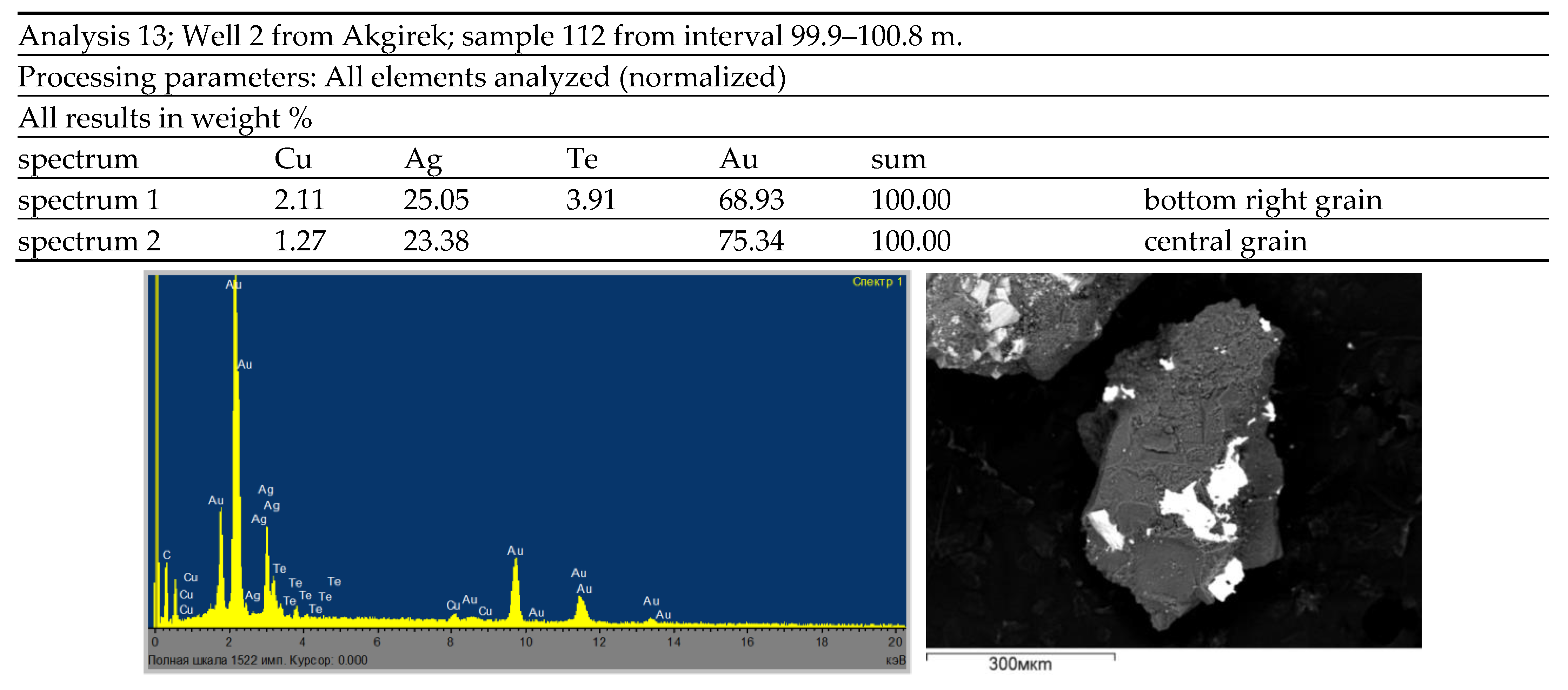
| 4 | Akgirek, L-43-6, S—2.0 | Q, Al, Sr, Z | Q, Sr, Al, Tr, An, Ds, Gm | Q, An, Al, Dk, Tr, Kl, Z, Py | Au, Ag, Cu, Mo, Pb, Bi | ||
| 5 | Kyra, M-43-138, S—4.5 | Q, Sr, Z | Q, Kl, S, Ds | Q, Sr, Kl | Q, Al, Dk, Sr, Kl, Gm | Q, Al, Dk, Kl, Sr, Gm | Cu, Mo, Bi, Au |
| 6 | Jalpakkain, M-43-138, S—10.0 | Q, Al, Ds, Tp, Sr, Z | Q, Al, Sr, Kl | Q, Al, Sr, Kl, Gm | Q, Al, Ds, Sr, Kl, Z | Q, Al, Prl, Sr, Kl, Gm | Au, Pb, Bi |
| 7 | Toreshoy, M-43-138, S—1.2 | Q, An, Ds, Al, Sr | Q, An, Co, Prl, Sr | Q, Al, Ds, Dk, Kl, Sr | Q, Sr, Al, Prl | Pb, Au | |
| 8 | Akshoky, L-43-29-A, S—5.5 | Q, An, Co, Al, Sr, Tr, Dk | Q, Sr, Kl, Gm | Au, Ag, Cu, Bi | |||
| 9 | Kuder, M-43-138, S—3.5 | Q, Al, Ds, An, Sr, Kl | Q, An, Gm, Sr, Dk, Ad | Bi, Ag, Au | |||
| 10 | North Akshoky, M-43-138, S—7.0 | Q, Al, Tp, Z, Dk, Sr | Q, Al, An, Ds, Sr, Kl | Q, Al, Sr, Dk | Pb, Au | ||
| 11 | Koyanshoky, M-43-138, S—0.5 | Q, An, Co, Al, Dk | Q, Al, Co, Tp, Ds, Sr, Gm | Q, Al, Sr, Gm | Q, Sr, Gm | Cu, Mo, Au | |
| 12 | Symbyl, L-43-29, S—2.5 | Q, Al, Ds, Sr, Dk | Q, Al, An, Ad, Ds, Dk, Gm, Py, Sr | Cu, Mo, Au, Bi | |||
| 13 | Sokurkoi, L-43-53, S—9.0 | Q, Al, An, Dk, Sr | Q, Al, Dk, An, Sr, Kl, Gm | Cu, Au, Ag | |||
| 14 | Sargul, L-43-29, S—12.0 | Q, Al, Ds, Sr | Q, Al, Sr, Dk, Ge, Kl, Gm | Cu, Au | |||
| 15 | Korgantas, M-43-137, S—1.2 | Q, An, Ds, Z, Ms | Q, Al, Kl, Sr, Gm | Q, Sr, Gm, Al, An | Cu, Au | ||
| 16 | Targyl, L-43-53, S—12.0 | Q, Al, An, Ds, Co, Z, Dk | Q, Dk, An, Al, Sr, Ds, Z | Au | |||
| 17 | Ktai, L-43-6-A, S—5.0 | Q, An, Kl, Sr | Q, Al, Kl, Sr | Cu, Mo, Au, Ag | |||
| 18 | Kose, L-43-17-A, S—10.0 | Q, Sr, Al, Kl, Gm | Q, Sr, Gm, Kl, Py | Au, As, Cu, Pb, Mo, Bi | |||
| 19 | Karateke, L-43-30-B, S—0.7 | Q, Sr, Kl | Q, An, Ds, Sr, Kl | Au, Ag, Bi, Cu, Pb, Mo | |||
| 20 | Shozek, L-43-30-A, S—5.0 | Q, An, Ds, Dk, Sr | Q, An, Tp, Dk, Kl, Sr, Gm, Ds | Au, Cu | |||
| 21 | Karabas, L-43-30-B, S—5.2 | Q, Al, Dk, Sr | Q, Kl, Sr | Q, Al, Dk, Kl, Sr, Gm | Cu, Au, Ag, Pb, | ||
| 22 | Itlay-Ushtobe, L-43-18-г, S—36.0 | Q, Co, An, Al, Ds, Sr | Q, Sr, Al, An, Ds | Au, Ag, Pb | |||
| 23 | Koskyzyl, L-43-42-A, S—4.0 | Q, An, Sr | Q, Al, Kl, Sr, Gm | Au | |||
| 24 | Borly, L-43-30-B, S—7.5 | Q, Co, An, Sr, Gm | Q, An, Sr, Gm | Cu, Mo, Au, Ag | |||
| 25 | Jusaly, M-43-137, S—15.0 | Q, Ds, Al, Sr | Q, Ds, Sr, Dk | Q, Al, Prl, Dk, Sr | Au, Cu, Pb | ||
| 26 | Korpetai, M-43-125, S—6.0 | Q, An, Al, Dm, Sr | Q, An, Al, Sr | Q, Al, An, Ds, Sr, Prl, Tr | Pb, Zn | ||
| 27 | Sheshen-Kara, L-43-28, S—32.0 | Q, Co, An, Al, Ds, Sr, Gm | Q, An, Al, Prl, Kl, Sr, Co | Al, Au | |||
| 28 | Bosaga, M-43-128, S—7.5 | Q, Co, An, Al, Ds, Dk, Sr | Q, Al, An, Co, Dk, Sr | Q, Co, An, Al, Dk, Kl, Sr | Al, Cu, Pb, Sb, Bi, Au, Ag | ||
| 29 | South Kyzylray group, M-43-128, S—6.5 | Q, Al, An, Sr, Kl, | Cu, Mo, Pb, Au | ||||
| 30 | Jorga, M-43-Г, S—18.0 | Q, Co, Al, Dk, Sr | Q, Al, Sr, Kl, Ds, Tp, Z | Cu, Au | |||
| 31 | Jaur, M-43-Г, S—30.0 | Q, Dk, Al, Co, Ds, Sr, Ba | Q, Al, Ds, Prl, An, Sr, Co, Gm | Mo, Cu, Pb, Zn, Au | |||
| Number of Wells | Types of Metasomatites | ||||||||
|---|---|---|---|---|---|---|---|---|---|
| Kaolinitization (Kl) | Silicification (Q) | Chloritization (Cl) | Carbonatization (Ca) and Epidotization (Ep) | Epidotization (Ep) and Adularization (Ad) | Sericitization (Sr) and K-Feldspathization (Kfsp) | Alunization (Aln) and Tourmalinization (Tu) | Pyritization | The Most Pervasive Types | |
| Well 1 | Kl-6 | Q-3 | Cl-9 | Ca-11 Ep 2 | Ep-2 | Sr-1 | - | Py-6 | Ca-11 |
| Well 2 | Kl-5 | Q-4 | Cl-2 | Ca-4 | - | Sr-2 | - | Py-14 | Kl-5 |
| Well 3 | Kl-8 | Q-6 | Cl-6 | Ep-2 | Ep-2 | Sr-4 | Aln-2 | Py-10 | Kl-8 |
| Well 4 | Kl-8 | Q-7 | Cl-1 | - | - | Sr-1 | - | Py-2 | Kl-8 |
| Well 5 | Kl-9 | Q-7 | Cl-3 | Ca-1 Ep 5 | Ep-5 | Sr-3 | Aln-1 | Py-5 | Kl-9 |
| Well 6 | Kl-8 | Q-2 | Cl-4 | - | - | Sr-2 | - | Py-4 | Kl-8 |
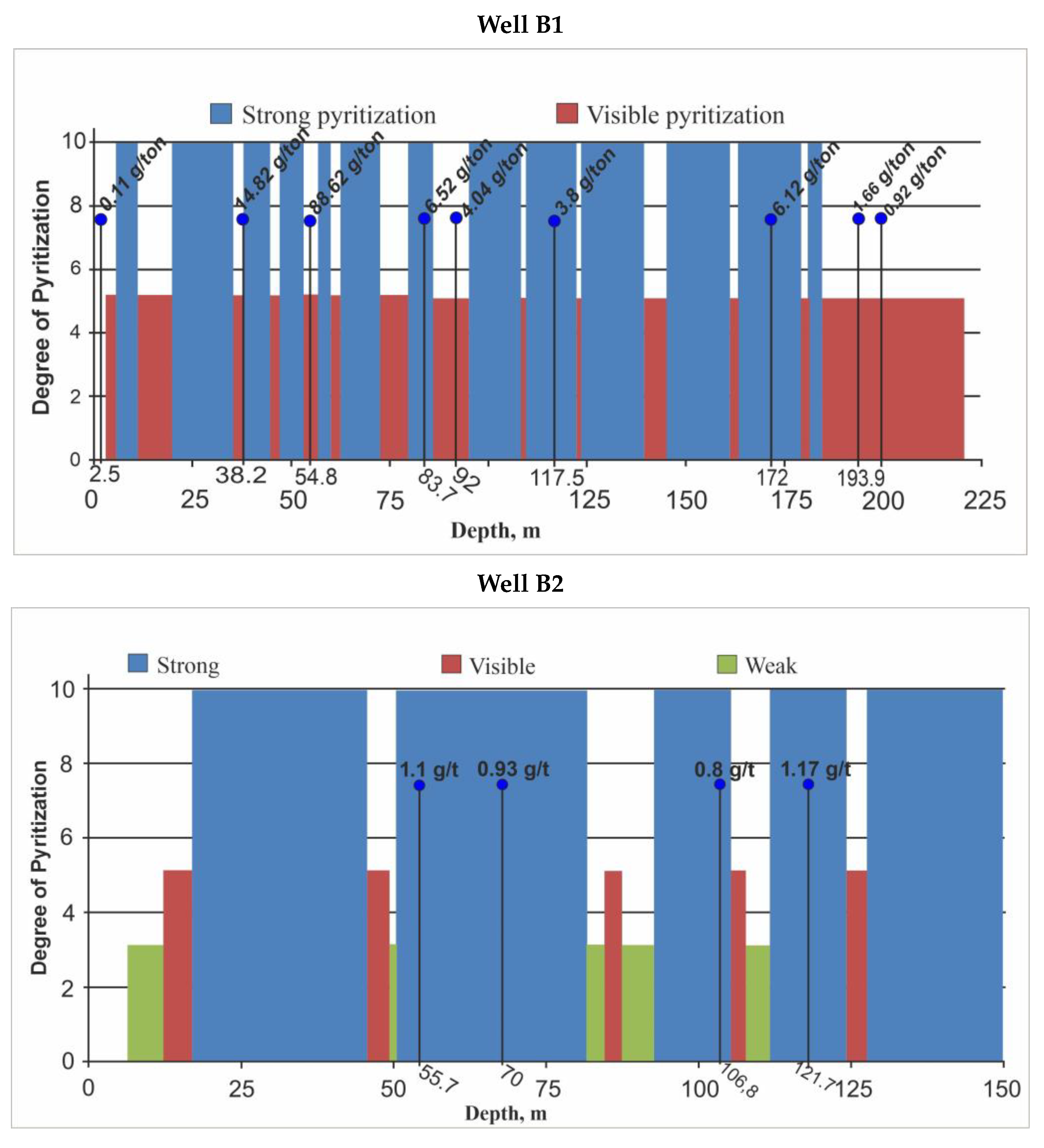
| Б1 | Kl-38 | Q-24 | Cl-5 | Ca-12 | Ad-8 | Sr-22 | Aln-5 Tu-4 | Py 91.2% | Kl-38 |
| Б2 | Kl-33 | Q-20 | Cl-15 | Ca-4 | Ad-2 | Sr-15 Kfsp-3 | Aln-15 Tu-7 | Kl-33 | |
| Well No. | Ore Element Concentration Clarks | Gold Companion Element Clarke Concentrations | ||||||
|---|---|---|---|---|---|---|---|---|
| Cu | Bi | Zn | Mo | Pb | Ag | As | ||
| 2 | Average | 0.02 | 0.0006 | 0.022 | 0.0028 | 0.0047 | 0.0001 | 0.01 |
| Clarke | 0.01 | 0.00005 | 0.022 | 0.0003 | 0.0016 | 0.00001 | 0.00024 | |
| Clarke concentration | 20 | 12 | 1.0 | 9.3 | 2.9 | 10 | 41.6 | |
| 4 | Average | 0.007 | 0.0004 | 0.023 | 0.02 | 0.005 | 0.00011 | 0.01 |
| Clarke | 0.01 | 0.00005 | 0.022 | 0.0003 | 0.0016 | 0.00001 | 0.00024 | |
| Clarke concentration | 0.7 | 8.0 | 1.05 | 6.66 | 3.2 | 10 | 41.6 | |
| 5 | Average | 0.005 | 0.0002. | 0.01 | 0.00056 | 0.03 | 0.00002 | 0.01 |
| Clarke | 0.01 | 0.00005 | 0.022 | 0.0003 | 0.0016 | 0.00001 | 0.00024 | |
| Clarke concentration | 0.5 | 4.0 | 0.45 | 1.86 | 1.87 | 2.0 | 41.6 | |
| 6 | Average | 0.007 | 0.0001 | 0.023 | 0.0013 | 0.04 | 0.0004 | 0.0017 |
| Clarke | 0.01 | 0.00005 | 0.022 | 0.0003 | 0.0016 | 0.00001 | 0.00024 | |
| Clarke concentration | 0.5 | 2.0 | 1.05 | 4.3 | 25 | 40 | 7 | |
| 7 | Average | 0.011 | 0.00007 | 0.006 | 0.0005 | 0.014 | 0.00011 | 0.0016 |
| Clarke | 0.01 | 0.0005 | 0.022 | 0.0003 | 0.0016 | 0.00001 | 0.00024 | |
| Clarke concentration | 1.1 | 1.4 | 0.3 | 1.66 | 8.8 | 1.0 | 6.6 | |
Disclaimer/Publisher’s Note: The statements, opinions and data contained in all publications are solely those of the individual author(s) and contributor(s) and not of MDPI and/or the editor(s). MDPI and/or the editor(s) disclaim responsibility for any injury to people or property resulting from any ideas, methods, instructions or products referred to in the content. |
© 2023 by the authors. Licensee MDPI, Basel, Switzerland. This article is an open access article distributed under the terms and conditions of the Creative Commons Attribution (CC BY) license (https://creativecommons.org/licenses/by/4.0/).
Share and Cite
Seitmuratova, E.Y.; Goryaeva, V.S.; Saidasheva, F.F.; Arshamov, Y.K.; Baratov, R.T.; Dautbekov, D.O.; Shadiyev, N.S.; Mashrapova, M.A.; Dauletuly, A.; Karimbekov, T.K. The Current State of Research on Secondary Quartzites of the Northern Segment of the Jungar-Balkhash Folded System and Their Au Mineralization (Central Kazakhstan). Minerals 2023, 13, 813. https://doi.org/10.3390/min13060813
Seitmuratova EY, Goryaeva VS, Saidasheva FF, Arshamov YK, Baratov RT, Dautbekov DO, Shadiyev NS, Mashrapova MA, Dauletuly A, Karimbekov TK. The Current State of Research on Secondary Quartzites of the Northern Segment of the Jungar-Balkhash Folded System and Their Au Mineralization (Central Kazakhstan). Minerals. 2023; 13(6):813. https://doi.org/10.3390/min13060813
Chicago/Turabian StyleSeitmuratova, Eleonora Y., Vera S. Goryaeva, Farida F. Saidasheva, Yalkunzhan K. Arshamov, Refat T. Baratov, Diyas O. Dautbekov, Nurgali S. Shadiyev, Moldir A. Mashrapova, Ansagan Dauletuly, and Tauassar K. Karimbekov. 2023. "The Current State of Research on Secondary Quartzites of the Northern Segment of the Jungar-Balkhash Folded System and Their Au Mineralization (Central Kazakhstan)" Minerals 13, no. 6: 813. https://doi.org/10.3390/min13060813