
Meso–Cenozoic Exhumation in the South Qinling Shan (Central China) Recorded by Detrital Apatite Fission-Track Dating of Modern River Sediments

 , ,
, ,
Abstract
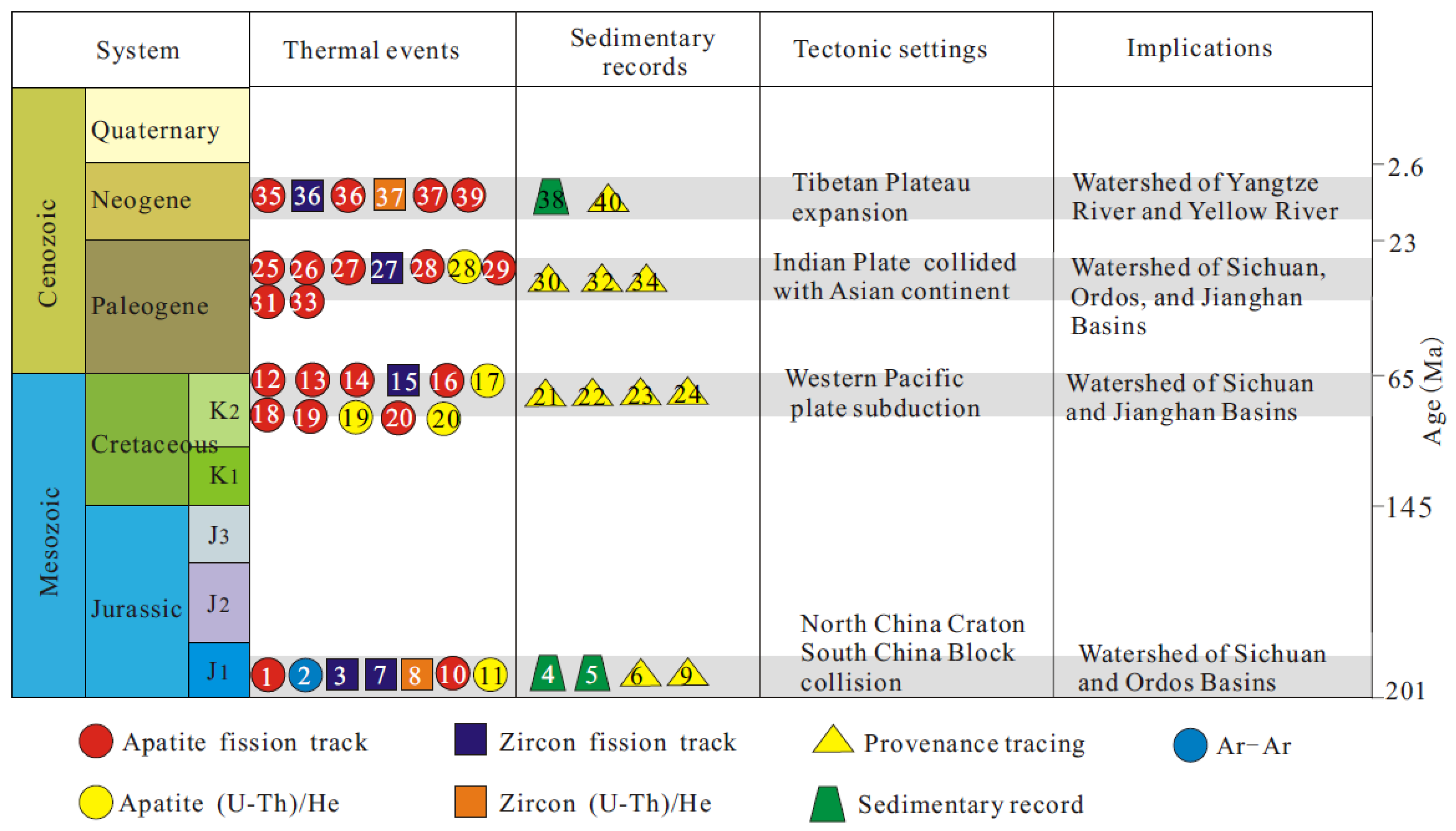
:1. Introduction
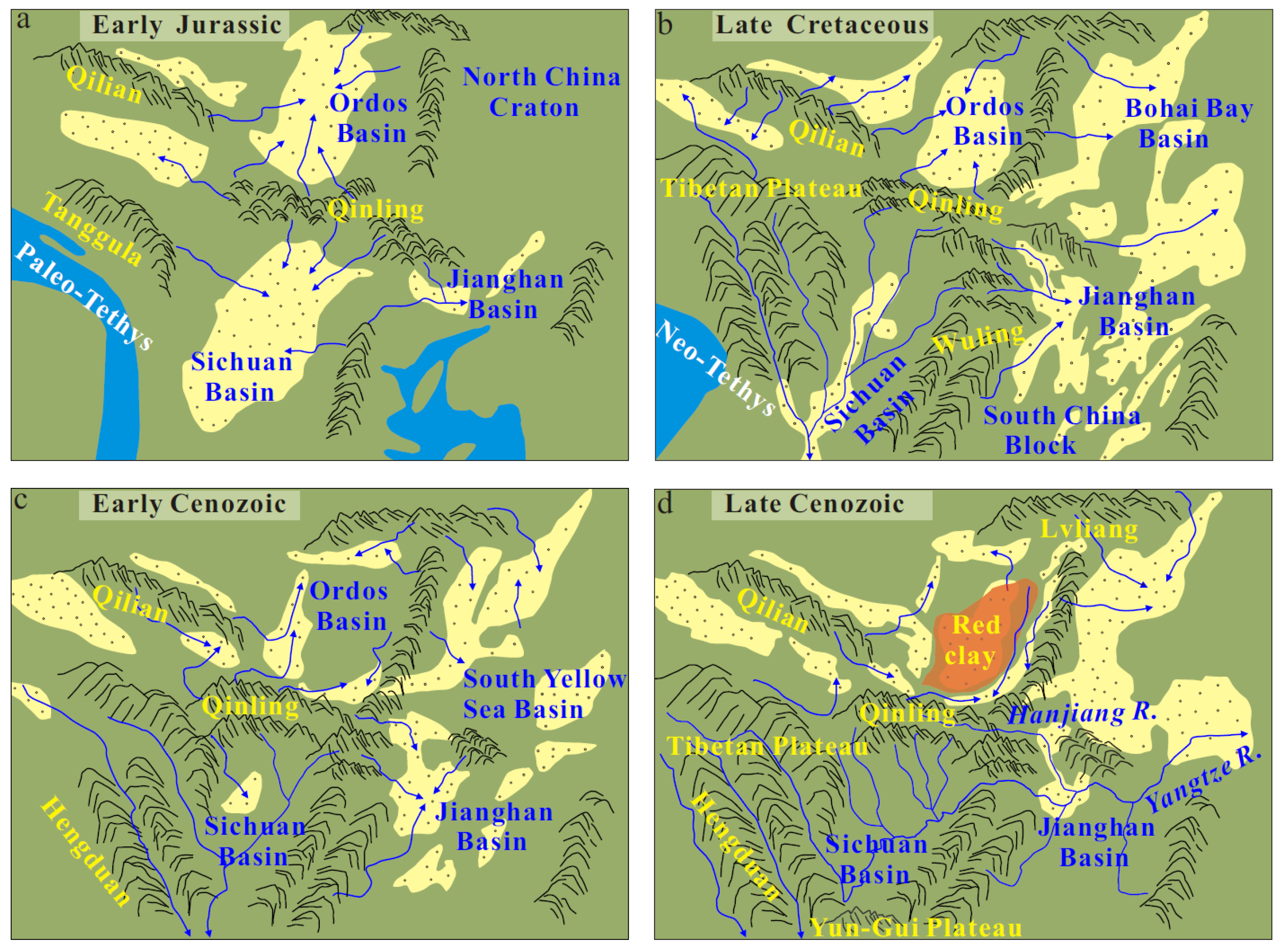
2. Geological Setting
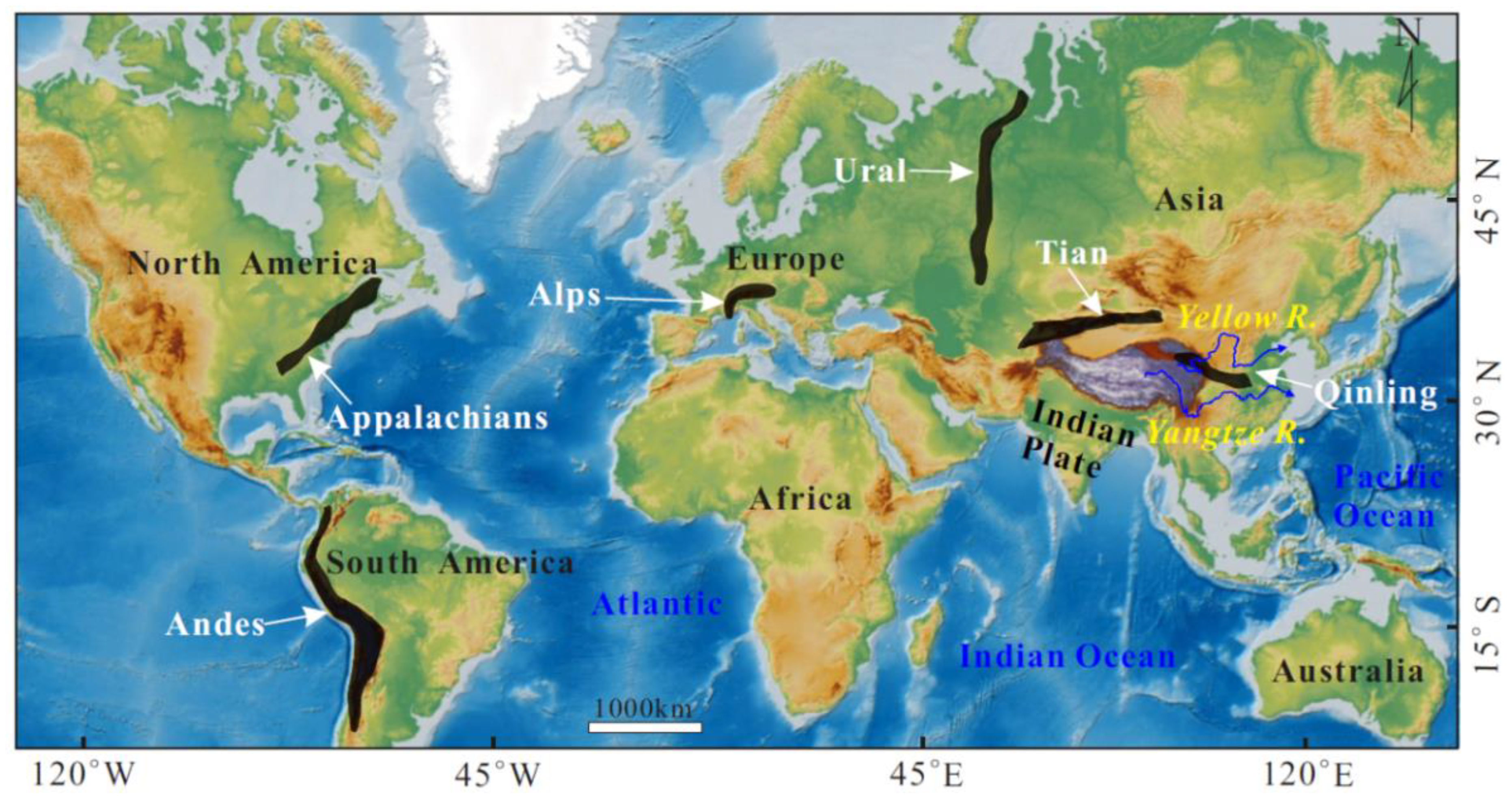
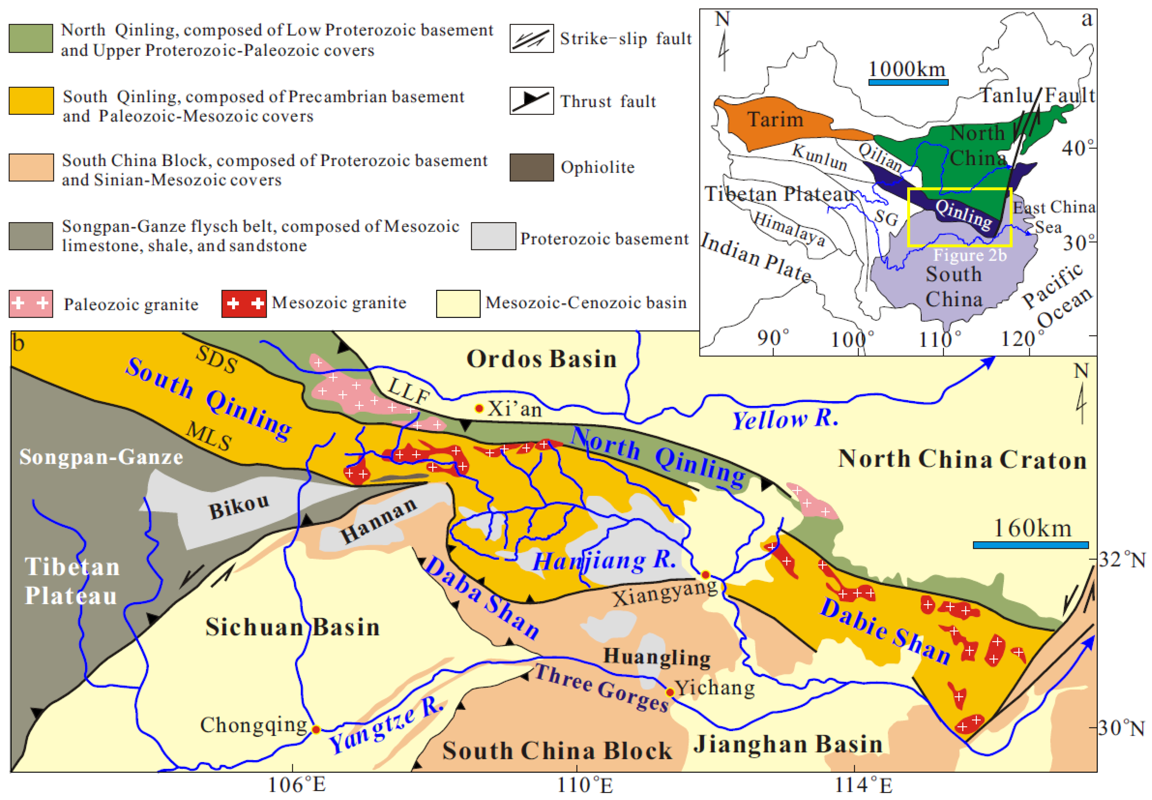
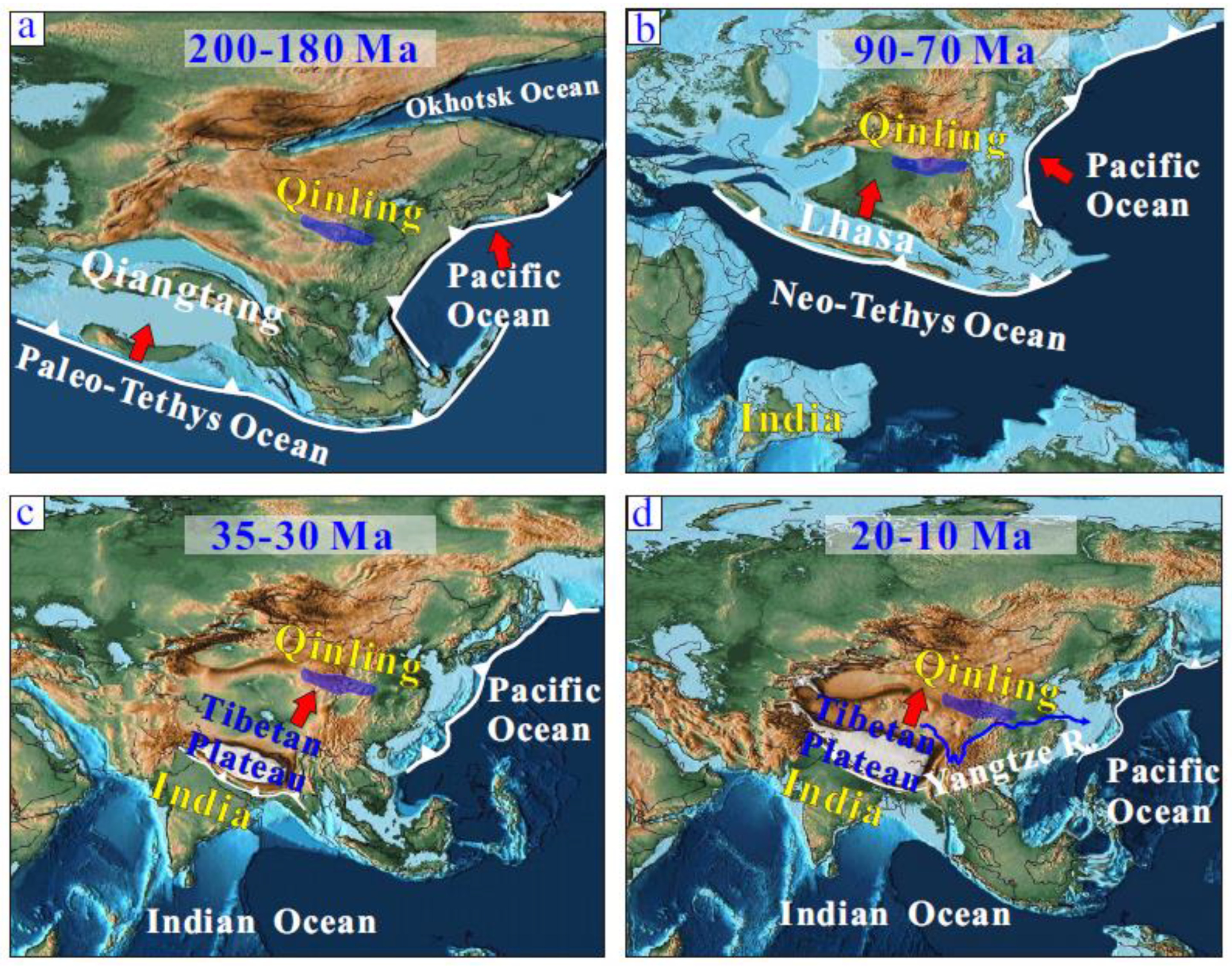
2.1. Qinling Shan

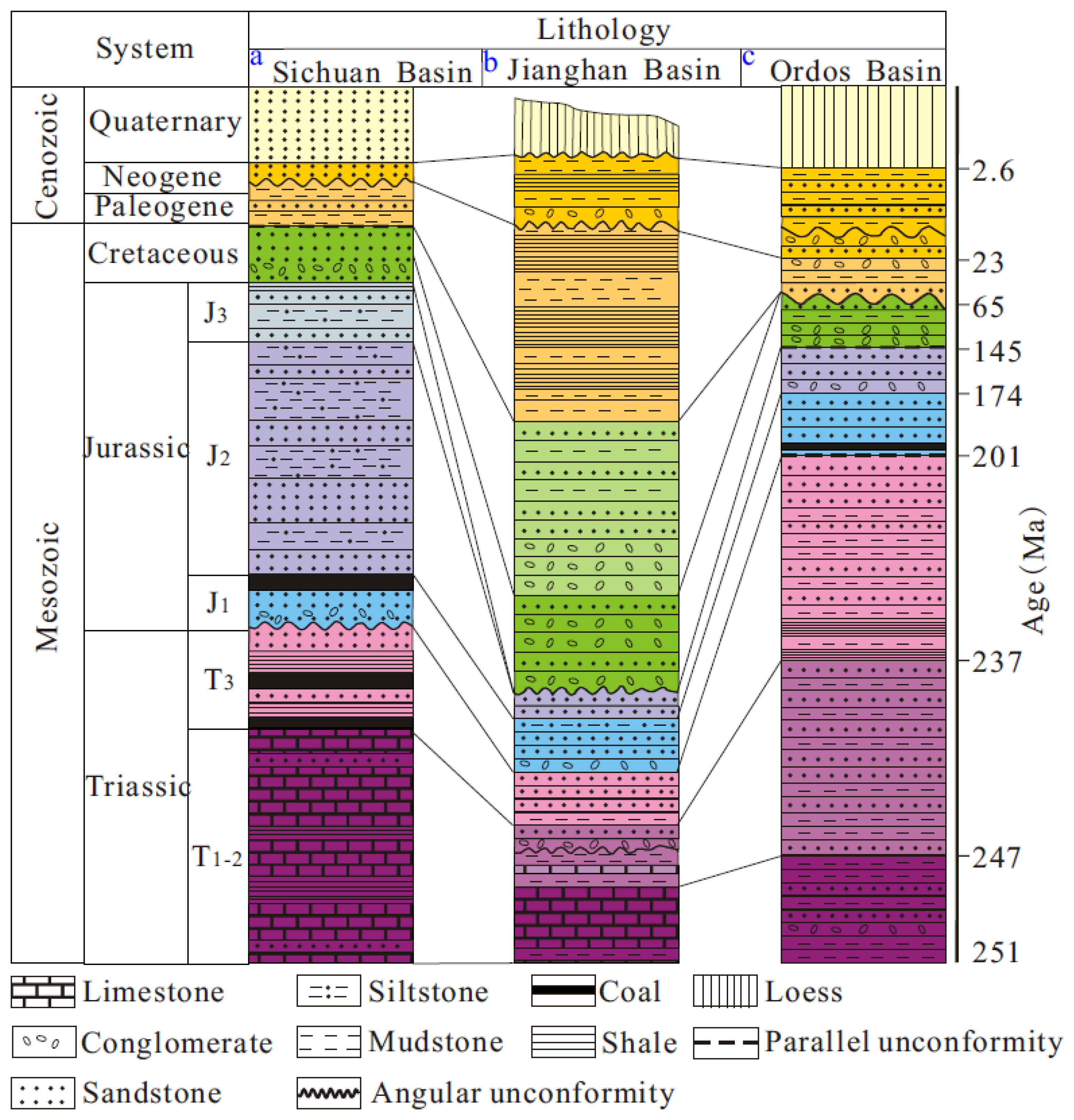
2.2. Sedimentary Basins
2.3. Rivers
3. Methods
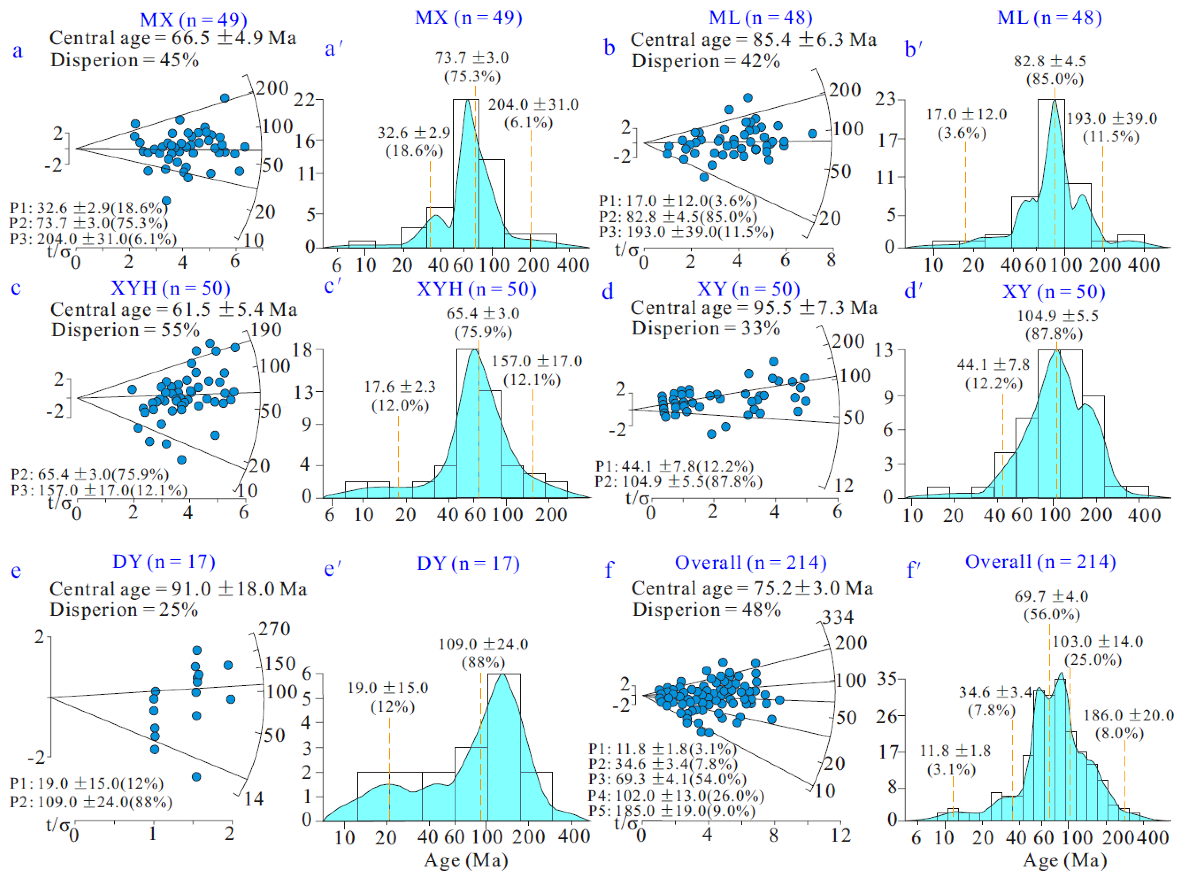
4. Results
5. Discussion
5.1. The Mesozoic Exhumation
5.2. Cenozoic Exhumation

5.3. Implications
6. Conclusions
Supplementary Materials
Author Contributions
Funding
Data Availability Statement
Acknowledgments
Conflicts of Interest
References
- Dewey, J.F.; Bird, J.M. Mountain belts and the new global tectonics. J. Geophys. Res. Earth Surf. 1970, 75, 2625–2647. [Google Scholar] [CrossRef]
- Dewey, J.F. Extensional collapse of orogens. Tectonics 1988, 7, 1123–1139. [Google Scholar] [CrossRef]
- Jolivet, M.; Dominguez, S.; Charreau, J.; Chen, Y.; Li, Y.; Wang, Q. Mesozoic and Cenozoic tectonic history of the central Chinese Tian Shan: Reactivated tectonic structures and active deformation. Tectonics 2010, 29, 1–30. [Google Scholar] [CrossRef]
- Dong, Y.; Shi, X.; Sun, S.; Sun, J.; Hui, B.; He, D.; Chong, F.; Yang, Z. Co-evolution of the Cenozoic tectonics, geomorphology, environment and ecosystem in the Qinling Mountains and adjacent areas, Central China. Geosyst. Geoenviron. 2022, 1, 100032. [Google Scholar] [CrossRef]
- Lin, X.; Liu, J.; Liu, W.; Zhang, P.; Wang, B.; Liu, H. Development and Evolution of Yellow River and Yangtze River; Geological Publishing House: Beijing, China, 2023; pp. 1–181, (In Chinese with English Abstract). [Google Scholar]
- Li, J.; Zhang, Y.; Dong, S.; Shi, W.; Li, H.L. Apatite fission track thermochronologic constraint on Late Mesozoic uplifting of the Fenghuangshan basement uplift. Chin. J. Geol. 2010, 45, 969–986, (In Chinese with English Abstract). [Google Scholar]
- Enkelmann, E.; Ratschbacher, L.; Jonckheere, R.; Nestler, R.; Fleischer, M.; Gloaguen, R.; Ma, S. Cenozoic exhumation and deformation of northeastern Tibet and the Qinling: Is Tibetan lower crustal flow diverging around the Sichuan Basin? Geol. Soc. Am. Bull. 2006, 118, 651–671. [Google Scholar] [CrossRef]
- Hu, S.; Raza, A.; Min, K.; Kohn, B.P.; Reiners, P.W.; Ketcham, R.A.; Wang, J.; Gleadow, A.J.W. Late Mesozoic and Cenozoic thermotectonic evolution along a transect from the north China craton through the Qinling orogen into the Yangtze craton, central China. Tectonics 2006, 25, 1–15. [Google Scholar] [CrossRef]
- Burbank, D.W.; Leland, J.; Fielding, E.; Anderson, R.S.; Brozovic, N.; Reid, M.R.; Duncan, C. Bedrock incision, rock uplift and threshold hillslopes in the northwestern Himalayas. Nature 1996, 379, 505–510. [Google Scholar] [CrossRef]
- Enkelmann, E.; Zeitler, P.K.; Pavlis, T.L.; Garver, J.I.; Ridgway, K.D. Intense localized rock uplift and erosion in the St Elias orogen of Alaska. Nat. Geosci. 2009, 2, 360–363. [Google Scholar] [CrossRef]
- Lin, X.; Tian, Y.; Donelick, R.A.; Liu-Zeng, J.; Cleber, S.J.; Wu, Q.; Li, Z. Mesozoic and Cenozoic tectonics of the north-eastern edge of the Tibetan plateau: Evidence from modern river detrital apatite fission-track age constraints. J. Asian Earth Sci. 2019, 170, 84–95. [Google Scholar] [CrossRef]
- Chen, H.; Hu, J.; Wu, G.; Shi, W.; Geng, Y.; Qu, H. Apatite fission-track thermochronological constraints on the pattern of late Mesozoic–Cenozoic uplift and exhumation of the Qinling Orogen, central China. J. Asian Earth Sci. 2015, 114, 649–673. [Google Scholar] [CrossRef]
- Liu, J.; Zhang, P.; Lease, R.O.; Zheng, D.; Wan, J.; Wang, W.; Zhang, H. Eocene onset and late Miocene acceleration of Cenozoic intracontinental extension in the North Qinling range–Weihe graben: Insights from apatite fission track thermo-chronology. Tectonophysics 2013, 584, 281–296. [Google Scholar] [CrossRef]
- Lease, R.O.; Burbank, D.W.; Clark, M.K.; Farley, K.A.; Zheng, D.; Zhang, H. Middle Miocene reorganization of defor-mation along the northeastern Tibetan Plateau. Geology 2011, 39, 359–362. [Google Scholar] [CrossRef]
- Wang, P.; Zheng, H.; Liu, S.; Hoke, G. Late Cretaceous drainage reorganization of the middle Yangtze River. Lithosphere 2018, 10, 392–405. [Google Scholar] [CrossRef]
- Richardson, N.; Densmore, A.; Seward, D.; Wipf, M.; Yong, L. Did incision of the Three Gorges begin in the Eocene? Geology 2010, 38, 551–554. [Google Scholar] [CrossRef]
- Yang, Z.; Shen, C.; Ratschbacher, L.; Enkelmann, E.; Jonckheere, R.; Wauschkuhn, B.; Dong, Y. Sichuan Basin and be-yond: Eastward foreland growth of the Tibetan Plateau from an integration of Late Cretaceous-Cenozoic fission track and (U-Th)/He ages of the eastern Tibetan Plateau, Qinling, and Daba Shan. J. Geophys. Res. Solid Earth 2017, 122, 4712–4740. [Google Scholar] [CrossRef]
- Garver, J.I.; Brandon, M.T.; Roden-Tice, M.; Kamp, P.J.J. Exhumation history of orogenic highlands determined by detrital fission-track thermochronology. Geol. Soc. London, Spéc. Publ. 1999, 154, 283–304. [Google Scholar] [CrossRef]
- Lin, X.; Jolivet, M.; Liu-Zeng, J.; Cheng, F.; Wu, Z.; Tian, Y.; Li, L.; Chen, J. The formation of the north qilian shan through time: Clues from detrital zircon fission-track data from modern river sediments. Geosciences 2022, 12, 166. [Google Scholar] [CrossRef]
- Huyghe, P.; Bernet, M.; Galy, A.; Naylor, M.; Cruz, J.; Gyawali, B.; Gemignani, L.; Mugnier, J.-L. Rapid exhumation since at least 13 Ma in the Himalaya recorded by detrital apatite fission-track dating of Bengal fan (IODP Expedition 354) and modern Himalayan river sediments. Earth Planet. Sci. Lett. 2020, 534, 116078. [Google Scholar] [CrossRef]
- Lin, X.; Jolivet, M.; Cheng, F. Spatiotemporal evolution of Central Qilian Shan (Northwest China) constrained by fis-sion-track ages of detrital grains from the Huangshui River. Minerals 2023, 13, 890. [Google Scholar] [CrossRef]
- Bernet, M.; Brandon, M.T.; Garver, J.I.; Molitor, B.R.; Spiegel, C. Fundamentals of detrital zircon fission-track analysis for provenance and exhumation studies with examples from the European Alps. Geol. Soc. Am. Spec. Publ. 2004, 378, 25–36. [Google Scholar]
- Bernet, M. Detrital zircon fission-track thermochronology of the present-day Isère River drainage system in the western alps: No evidence for increasing erosion rates at 5 Ma. Geosciences 2013, 3, 528–542. [Google Scholar] [CrossRef]
- Malusà, M.G.; Zattin, M.; Andò, S.; Garzanti, E.; Vezzoli, G. Focused erosion in the Alps constrained by fission-track ages on detrital apatites. Geol. Soc. London, Spéc. Publ. 2009, 324, 141–152. [Google Scholar] [CrossRef]
- Urueña-Suárez, C.L.; Peña-Urueña, M.L.; Muñoz-Rocha, J.A.; Rayo-Rocha, L.P.; Villamizar-Escalante, N.; Amaya-Ferreira, S.; Bernet, M. Zircon U–Pb and fission–track dating applied to resolving sediment provenance in modern rivers draining the Eastern and Central Cordilleras, Colombia. Serv. Geol. Colomb. Publ. Geol. Espec 2020, 37, 1–23. [Google Scholar]
- Carrapa, B.; Mustapha, F.S.; Cosca, M.; Gehrels, G.; Schoenbohm, L.M.; Sobel, E.R.; DeCelles, P.G.; Russell, J.; Goodman, P. Multisystem dating of modern river detritus from Tajikistan and China: Implications for crustal evolution and exhumation of the Pamir. Lithosphere 2014, 6, 443–455. [Google Scholar] [CrossRef]
- Li, L.; Najman, Y.; Dupont-Nivet, G.; Parra, M.; Roperch, P.; Kaya, M.; Aminov, J. Mesozoic–Cenozoic multistage tec-tonic evolution of the Pamir: Detrital fission-track constraints from the Tajik Basin. Basin Res. 2023, 35, 530–550. [Google Scholar] [CrossRef]
- You, J.; Yang, Z.; Shi, X.; Shen, C.; Dong, Y.; Cheng, B. Exhumation and deformation of the Daba Shan Orocline as determined from modern river sands apatite fission-track. J. Earth Sci. 2023, 34, 1140–1149. [Google Scholar] [CrossRef]
- Dong, Y.; Zhang, G.; Neubauer, F.; Liu, X.; Genser, J.; Hauzenberger, C. Tectonic evolution of the Qinling orogen, China: Review and synthesis. J. Asian Earth Sci. 2011, 41, 213–237. [Google Scholar] [CrossRef]
- Li, J.; Zhang, Y.; Dong, S.; Shi, W. Structural and geochronological constraints on the Mesozoic tectonic evolution of the North Dabashan zone, South Qinling, central China. J. Asian Earth Sci. 2013, 64, 99–114. [Google Scholar] [CrossRef]
- Meng, Q.-R.; Zhang, G.-W. Geologic framework and tectonic evolution of the Qinling orogen, central China. Tectonophysics 2000, 323, 183–196. [Google Scholar] [CrossRef]
- Enkin, R.J.; Yang, Z.; Chen, Y.; Courtillot, V. Paleomagnetic constraints on the geodynamic history of the major blocks of China from the Permian to the present. J. Geophys. Res. Solid Earth 1992, 97, 13953–13989. [Google Scholar] [CrossRef]
- Dong, S.; Zhang, Y.; Long, C.; Yang, Z.; Ji, Q.; Wang, T.; Hu, J.; Chen, X. Jurassic tectonic revolution in China and new interpretation of the “Yanshan Movement”. Acta Geol. Sin. Engl. Ed. 2008, 82, 334–347. [Google Scholar]
- Song, P.; Teng, J.; Zhang, X.; Liu, Y.; Si, X.; Ma, X.; Qiao, Y.; Dong, X. Flyover crustal structures beneath the Qinling Orogenic Belt and its tectonic implications. J. Geophys. Res. Solid Earth 2018, 123, 6703–6718. [Google Scholar] [CrossRef]
- Li, S.; Guo, L.; Xu, L.; Somerville, I.D.; Cao, X.; Yu, S.; Wang, P.; Suo, Y.; Liu, X.; Zhao, S. Coupling and transition of Meso–Cenozoic intracontinental deformation between the Taihang and Qinling Mountains. J. Asian Earth Sci. 2015, 114, 188–202. [Google Scholar] [CrossRef]
- Shi, X.; Yang, Z.; Dong, Y.; Qu, H.; Zhou, B.; Cheng, B. Geomorphic indices and longitudinal profile of the Daba Shan, northeastern Sichuan Basin: Evidence for the late Cenozoic eastward growth of the Tibetan Plateau. Geomorphology 2020, 353, 107031. [Google Scholar] [CrossRef]
- Einsele, G. Sedimentary Basins: Evolution, Facies, and Sediment Budget; Springer: Berlin/Heidelberg, Germany, 2020; pp. 1–781. [Google Scholar]
- Zhai, M.; Santosh, M. Metallogeny of the North China Craton: Link with secular changes in the evolving Earth. Gondwana Res. 2013, 24, 275–297. [Google Scholar] [CrossRef]
- Luo, L.; Qi, J.-F.; Zhang, M.-Z.; Wang, K.; Han, Y.-Z. Detrital zircon U–Pb ages of Late Triassic–Late Jurassic deposits in the western and northern Sichuan Basin margin: Constraints on the foreland basin provenance and tectonic implications. Int. J. Earth Sci. 2014, 103, 1553–1568. [Google Scholar] [CrossRef]
- Shi, W.; Dong, S.-W.; Ratschbacher, L.; Tian, M.; Li, J.-H.; Wu, G.-L. Meso-Cenozoic tectonic evolution of the Dangyang Basin, north-central Yangtze craton, central China. Int. Geol. Rev. 2013, 55, 382–396. [Google Scholar] [CrossRef]
- Xu, Y.; He, D. Triassic provenance shifts and tectonic evolution of southeast Ordos Basin, Central China. Palaeogeogr. Palaeoclim. Palaeoecol. 2022, 598, 111002. [Google Scholar] [CrossRef]
- Li, Z.C.; Li, W.H.; Li, Y.X.; Li, Y.H.; Han, W. Cenozoic stratigraphy and Paleoenvironments in the Weihe area, Shaanxi province. Stratigraphy 2016, 40, 168–179. [Google Scholar]
- Liu-Zeng, J.; Tapponnier, P.; Gaudemer, Y.; Ding, L. Quantifying landscape differences across the Tibetan plateau: Im-plications for topographic relief evolution. J. Geophys. Res. Earth Surf. 2008, 113, 1–26. [Google Scholar] [CrossRef]
- Clark, M.K.; Schoenbohm, L.M.; Royden, L.H.; Whipple, K.X.; Burchfiel, B.C.; Zhang, X.; Tang, W.; Wang, E.; Chen, L. Surface uplift, tectonics, and erosion of eastern Tibet from large-scale drainage patterns. Tectonics 2004, 23, 1–21. [Google Scholar] [CrossRef]
- Brookfield, M. The evolution of the great river systems of southern Asia during the Cenozoic India-Asia collision: Rivers draining southwards. Geomorphology 1998, 22, 285–312. [Google Scholar] [CrossRef]
- Xie, W.; Wang, X.; Zhang, H.; Liu, Q.; Wang, S.; Lu, H. Drainage evolution in intermontane basins at the Qinling-Daba Mountains. Sci. China Earth Sci. 2021, 64, 1949–1968. [Google Scholar] [CrossRef]
- Clift, P.D.; Van Long, H.; Hinton, R.; Ellam, R.M.; Hannigan, R.; Tan, M.T.; Blusztajn, J.; Duc, N.A. Evolving east Asian river systems reconstructed by trace element and Pb and Nd isotope variations in modern and ancient Red River-Song Hong sediments. Geochem. Geophys. Geosyst. 2008, 9, 1–29. [Google Scholar] [CrossRef]
- Zheng, H.; Clift, P.D.; He, M.; Bian, Z.; Liu, G.; Liu, X.; Xia, L.; Yang, Q.; Jourdan, F. Formation of the First Bend in the late Eocene gave birth to the modern Yangtze River, China. Geology 2021, 49, 35–39. [Google Scholar] [CrossRef]
- Yan, Y.; Yao, D.; Tian, Z.; Huang, C.; Dilek, Y.; Clift, P.D.; Li, Z. Tectonic topography changes in cenozoic east asia: A landscape erosion-sediment archive in the South China Sea. Geochem. Geophys. Geosyst. 2018, 19, 1731–1750. [Google Scholar] [CrossRef]
- Fu, X.; Zhu, W.; Geng, J.; Yang, S.; Zhong, K.; Huang, X.; Zhang, L.; Xu, X. The present-day Yangtze River was established in the late Miocene: Evidence from detrital zircon ages. J. Asian Earth Sci. 2021, 205, 104600. [Google Scholar] [CrossRef]
- Shen, X.; Tian, Y.; Li, D.; Qin, S.; Vermeesch, P.; Schwanethal, J. Oligocene-Early Miocene river incision near the first bend of the Yangze River: Insights from apatite (U-Th-Sm)/He thermochronology. Tectonophysics 2016, 687, 223–231. [Google Scholar] [CrossRef]
- Su, H.; Dong, M.; Hu, Z. Late Miocene birth of the Middle Jinsha River revealed by the fluvial incision rate. Glob. Planet. Chang. 2019, 183, 103002. [Google Scholar] [CrossRef]
- Zhang, D.; Cao, K.; Yuan, X.; Wang, G.; van der Beek, P. Late Oligocene-early Miocene Origin of the First Bend of the Yangtze River explained by thrusting-induced river reorganization. Geomorphology 2022, 411, 108303. [Google Scholar] [CrossRef]
- Liu, Y. Neogene fluvial sediments in the northern Jinshaan Gorge, China: Implications for early development of the Yellow River since 8 Ma and its response to rapid subsidence of the Weihe-Shanxi Graben. Palaeogeogr. Palaeoclim. Palaeoecol. 2020, 546, 109675. [Google Scholar] [CrossRef]
- Bao, G.; Chen, H.; Zhao, X. Late Miocene Yellow River formation in Qingtongxia area, North China: Detrital zircon and heavy mineral analysis at Niushou Mountain, Ningxia. Geol. J. 2020, 55, 7304–7321. [Google Scholar] [CrossRef]
- Lu, H.; Wang, X.; An, Z.; Miao, X.; Zhu, R.; Ma, H.; Wang, X. Geomorphologic evidence of phased uplift of the north-eastern Qinghai-Tibet Plateau since 14 million years ago. Sci. China Ser. D Earth Sci. 2004, 47, 822–833. [Google Scholar] [CrossRef]
- Kong, P.; Jia, J.; Zheng, Y. Time constraints for the Yellow River traversing the Sanmen Gorge. Geochem. Geophys. Geosyst. 2014, 15, 395–407. [Google Scholar] [CrossRef]
- Yang, J.; Yuan, H.; Hu, Y.; Wang, F. Significance of sedimentary provenance reconstruction based on borehole records of the North China Plain for the evolution of the Yellow River. Geomorphology 2022, 401, 108077. [Google Scholar] [CrossRef]
- Sobel, E.; Seward, D. Influence of etching conditions on apatite fission-track etch pit diameter. Chem. Geol. 2010, 271, 59–69. [Google Scholar] [CrossRef]
- Hasebe, N.; Barbarand, J.; Jarvis, K.; Carter, A.; Hurford, A.J. Apatite fission-track chronometry using laser ablation ICP-MS. Chem. Geol. 2004, 207, 135–145. [Google Scholar] [CrossRef]
- Soares, C.J.; Guedes, S.; Hadler, J.C.; Mertz-Kraus, R.; Zack, T.; Iunes, P.J. Novel calibration for LA-ICP-MS-based fis-sion-track thermochronology. Phys. Chem. Miner. 2014, 41, 65–73. [Google Scholar] [CrossRef]
- Hurford, A.J.; Green, P.F. The zeta age calibration of fission-track dating. Chem. Geol. 1983, 41, 285–317. [Google Scholar] [CrossRef]
- McDowell, F.A.; McIntosh, W.C.; Farley, K. A precise 40Ar–39Ar reference age for the Durango apatite (U–Th)/He and fission-track dating standard. Chem. Geol. 2005, 214, 249–263. [Google Scholar] [CrossRef]
- Vermeesch, P. On the visualisation of detrital age distributions. Chem. Geol. 2012, 312–313, 190–194. [Google Scholar] [CrossRef]
- Yin, A.; Nie, S. An indentation model for the North and South China collision and the development of the Tan-Lu and Honam Fault Systems, eastern Asia. Tectonics 1993, 12, 801–813. [Google Scholar] [CrossRef]
- Lu, G.; Li, C.; Li, W.; Deng, S.; Zhang, J. Structural geometry and kinematics of thrust belts between the Dabashan and eastern Sichuan Basin, South China block: Constraints from (U-Th)/He dating and seismic data. GSA Bull. 2021, 133, 1749–1764. [Google Scholar] [CrossRef]
- Wu, C.; Zuza, A.V.; Levy, D.A.; Li, J.; Ding, L. Discovery of Permian–Triassic eclogite in northern Tibet establishes coeval subduction erosion along an ~3000-km-long arc. Geology 2023, 51, 833–838. [Google Scholar] [CrossRef]
- Yang, Z.; Ratschbacher, L.; Jonckheere, R.; Enkelmann, E.; Dong, Y.; Shen, C.; Wiesinger, M.; Zhang, Q. Late-stage foreland growth of China’s largest orogens (Qinling, Tibet): Evidence from the Hannan-Micang crystalline massifs and the northern Sichuan Basin, central China. Lithosphere 2013, 5, 420–437. [Google Scholar] [CrossRef]
- Liu, S.; Heller, P.L.; Zhang, G. Mesozoic basin development and tectonic evolution of the Dabieshan orogenic belt, central China. Tectonics 2003, 22, 1–21. [Google Scholar] [CrossRef]
- Li, Y.; He, D.; Li, D.; Lu, R.; Fan, C.; Sun, Y.; Huang, H. Sedimentary provenance constraints on the Jurassic to Cretaceous paleogeography of Sichuan Basin, SW China. Gondwana Res. 2018, 60, 15–33. [Google Scholar] [CrossRef]
- Meng, L.; Chen, W.; Shen, T.; Cai, J. A Study on the provenance of Early to Late Triassic clastic rocks from the North-western Sichuan Basin, Southwestern China: Constraints on the early Mesozoic tectonic evolution of the western Yangtze Block. Front. Earth Sci. 2022, 10, 940301. [Google Scholar] [CrossRef]
- Cao, Z.; Deng, B.; Hu, X.; Yang, R.; Xu, H.; Liu, C.; Qiu, Y.; Zheng, C.; Liu, G.; Liu, S. Tectonic chronology and sedimentary response characteristics of the late Triassic source sink system in the northwestern margin of Sichuan. Nat. Gas Geosci. 2023, 10, 1–20, (In Chinese with English Abstract). [Google Scholar]
- Xie, X. Provenance and sediment dispersal of the Triassic Yanchang Formation, southwest Ordos Basin, China, and its implications. Sediment. Geol. 2016, 335, 1–16. [Google Scholar] [CrossRef]
- Yu, Q.; Ren, Z.; Li, R.; Ling, C.; Ni, T.; Lei, W.; Wang, B.; Wu, X.; Qin, X.; Lei, X. Different burial-cooling history of Triassic strata between the western Weibei Uplift and the Northwestern Weihe Basin in Northwest China. J. Earth Sci. 2023, 1–13. [Google Scholar] [CrossRef]
- Yu, Q.; Ren, Z.; Li, R.; Chung, L.; Tao, N.; Cui, J.; Wang, B.; Qi, K.; Khaled, A. Cooling history of the southwestern Ordos Basin (northern China) since Late Jurassic: Insights from thermochronology and geothermometry. J. Asian Earth Sci. 2021, 219, 104895. [Google Scholar] [CrossRef]
- Shen, C.; Hu, D.; Shao, C.; Mei, L. Thermochronology quantifying exhumation history of the Wudang Complex in the South Qinling Orogenic Belt, central China. Geol. Mag. 2018, 155, 893–906. [Google Scholar] [CrossRef]
- Wang, M.; Tian, Y.; Zhou, B.; Jiao, R.; Zhang, G. Instant far-field effects of continental collision: An example study in the Qinling Orogen, northeast of the Tibetan Plateau. Tectonophysics 2022, 833, 229334. [Google Scholar] [CrossRef]
- Reiners, P.W.; Zhou, Z.; Ehlers, T.A.; Xu, C.; Brandon, M.T.; Donelick, R.A.; Nicolescu, S. Post-orogenic evolution of the Dabie Shan, eastern China, from (U-Th)/He and fission-track thermochronology. Am. J. Sci. 2003, 303, 489–518. [Google Scholar] [CrossRef]
- Shen, C.-B.; Mei, L.-F.; Xu, S.-H. Fission track dating of Mesozoic sandstones and its tectonic significance in the Eastern Sichuan Basin, China. Radiat. Meas. 2009, 44, 945–949. [Google Scholar] [CrossRef]
- Tian, Y.; Qiu, N.; Kohn, B.P.; Zhu, C.; Hu, S.; Gleadow, A.J.; McInnes, B.I. Detrital zircon (U–Th)/He thermochronometry of the Mesozoic Daba Shan Foreland Basin, central China: Evidence for timing of post-orogenic denudation. Tectonophysics 2012, 570, 65–77. [Google Scholar] [CrossRef]
- Peng, L.; Shen, C.; Yang, Z.; Ge, X. Apatite fission-track data from upper Cretaceous formations in the Yuan’an Graben (China): Constraints on the timing of synsedimentary fault activity. Radiat. Meas. 2013, 50, 187–191. [Google Scholar] [CrossRef]
- Yang, F.; Jepson, G.; Liu, C.; Qian, Z.; Zhang, X.; Zhang, Y.; Glorie, S. Uplift-exhumation and preservation of the Yumugou Mo-W deposit, East Qinling, China: Insights from multiple apatite low-temperature thermochronology. Ore Geol. Rev. 2022, 141, 104670. [Google Scholar] [CrossRef]
- Shen, C.; Mei, L.; Peng, L.; Chen, Y.; Yang, Z.; Hong, G. LA-ICPMS U–Pb zircon age constraints on the provenance of Cretaceous sediments in the Yichang area of the Jianghan Basin, central China. Cretac. Res. 2012, 34, 172–183. [Google Scholar] [CrossRef]
- Chen, Y.; Li, J.; Miao, P.; Chen, L.; Zhao, H.; Wang, C. U-Pb ages and Hf isotopes of detrital zircons from the Cretaceous succession in the southwestern Ordos Basin, Northern China: Implications for provenance and tectonic evolution. J. Asian Earth Sci. 2021, 219, 104896. [Google Scholar] [CrossRef]
- Li, J.; Zhang, Y.; Dong, S.; Johnston, S.T. Cretaceous tectonic evolution of South China: A preliminary synthesis. Earth-Sci. Rev. 2014, 134, 98–136. [Google Scholar] [CrossRef]
- Dong, S.; Li, J.; Gao, R.; Cawood, P.A.; Thybo, H.; Johnston, S.T.; Jiao, L.; Zhang, Y.; Wang, J. Intraplate lithospheric extension revealed by seismic reflection profiling of South China. Earth Planet. Sci. Lett. 2023, 609, 118100. [Google Scholar] [CrossRef]
- Li, J.; Dong, S.; Cawood, P.A.; Thybo, H.; Clift, P.D.; Johnston, S.T.; Zhao, G.; Zhang, Y. Cretaceous long-distance lithospheric extension and surface response in South China. Earth-Sci. Rev. 2023, 243, 104496. [Google Scholar] [CrossRef]
- Clark, M.K.; Farley, K.A.; Zheng, D.; Wang, Z.; Duvall, A.R. 2010. Early Cenozoic faulting of the northern Tibetan Plateau margin from apatite (U–Th)/He ages. Earth Planet. Sci. Lett. 2010, 296, 78–88. [Google Scholar] [CrossRef]
- He, P.; Wang, X.; Song, C.; Wang, Q.; Deng, L.; Zhong, S. Cenozoic evolution of the Western Qinling Mt. Range based on thermochronologic and sedimentary records from the Wudu Basin, NE Tibetan Plateau. J. Asian Earth Sci. 2017, 138, 484–494. [Google Scholar] [CrossRef]
- Zhang, Y.-P.; Zheng, W.-J.; Wang, W.-T.; Tian, Y.-T.; Zhou, R.; Xu, B.-B.; Li, M.-J.; Yan, Y.-G.; Tian, Q.-Y.; Zhang, P.-Z. Rapid eocene exhumation of the West Qinling Belt: Implications for the growth of the Northeastern Tibetan Plateau. Lithosphere 2020, 2020, 8294751. [Google Scholar] [CrossRef]
- Wang, X.; Zattin, M.; Li, J.; Song, C.; Peng, T.; Liu, S.; Liu, B. Eocene to Pliocene exhumation history of the Tianshui-Huicheng region determined by Apatite fission track thermochronology: Implications for evolution of the north-eastern Tibetan Plateau margin. J. Asian Earth Sci. 2011, 42, 97–110. [Google Scholar] [CrossRef]
- Wang, W.; Zhang, P.; Liu, C.; Zheng, D.; Yu, J.; Zheng, W.; Chen, X. Pulsed growth of the West Qinling at ~30 Ma in northeastern Tibet: Evidence from Lanzhou Basin magnetostratigraphy and provenance. J. Geophys. Res. Solid Earth 2016, 121, 7754–7774. [Google Scholar] [CrossRef]
- Ge, X.; Shen, C.; Yang, Z.; Mei, L.; Xu, S.; Peng, L.; Liu, Z. Low-temperature thermochronology constraints on the mes-ozoic-cenozoic exhumation of the Huangling massif in the Middle Yangtze Block, Central China. J. Earth Sci. 2013, 24, 541–552. [Google Scholar] [CrossRef]
- Wu, L.; Mei, L.; Liu, Y.; Luo, J.; Min, C.; Lu, S.; Guo, L. Multiple provenance of rift sediments in the composite ba-sin-mountain system: Constraints from detrital zircon U-Pb geochronology and heavy minerals of the early Eocene Jianghan Basin, central China. Sediment. Geol. 2017, 349, 46–61. [Google Scholar] [CrossRef]
- Yang, C.; Shen, C.; Zattin, M.; Yu, W. Formation of the Yangtze Three Gorges: Insights from detrital apatite fission-track dating of sediments from the Jianghan Basin. Terra Nova 2021, 33, 511–520. [Google Scholar] [CrossRef]
- Chen, B.-L.; Yin, G.-M.; Li, W.-L.; Guo, L.; Li, L.; Lu, Y.-C.; Guo, S.-L. Determination of tectonic uplift rates of Qinling mountains in central China by fission tracks. Radiat. Meas. 2001, 34, 405–408. [Google Scholar] [CrossRef]
- Lu, H.; Zhang, H.; Feng, H.; Wang, Y.; Cai, D.; Li, G.; Lyu, H.; Lei, F.; Wang, K.; Wang, S.; et al. Landform evolution in Asia during the Cenozoic revealed by formation of drainages of Wei River and Indus River. Palaeogeogr. Palaeoclim. Palaeoecol. 2023, 619, 111516. [Google Scholar] [CrossRef]
- Wang, C.; Dai, J.; Zhao, X.; Li, Y.; Graham, S.A.; He, D.; Ran, B.; Meng, J. Outward-growth of the Tibetan Plateau during the Cenozoic: A review. Tectonophysics 2014, 621, 1–43. [Google Scholar] [CrossRef]
- Ding, L.; Kapp, P.; Cai, F.; Garzione, C.N.; Xiong, Z.; Wang, H.; Wang, C. Timing and mechanisms of Tibetan Plateau uplift. Nat. Rev. Earth Environ. 2022, 3, 652–667. [Google Scholar] [CrossRef]
- Deng, B.; Liu, S.-G.; Li, Z.-W.; Jansa, L.F.; Liu, S.; Wang, G.-Z.; Sun, W. Differential exhumation at eastern margin of the Tibetan Plateau, from apatite fission-track thermochronology. Tectonophysics 2013, 591, 98–115. [Google Scholar] [CrossRef]
- Molnar, P.; England, P.; Martinod, J. Mantle dynamics, uplift of the Tibetan Plateau, and the Indian monsoon. Rev. Geophys. 1993, 31, 357–396. [Google Scholar] [CrossRef]
- Jolivet, M.; Brunel, M.; Seward, D.; Xu, Z.; Yang, J.; Roger, F.; Tapponnier, P.; Malavieille, J.; Arnaud, N.; Wu, C. Mesozoic and Cenozoic tectonics of the northern edge of the Tibetan plateau: Fission-track constraints. Tectonophysics 2001, 343, 111–134. [Google Scholar] [CrossRef]
- Tian, Y.; Li, R.; Tang, Y.; Xu, X.; Wang, Y.; Zhang, P. Thermochronological constraints on the late Cenozoic mor-photectonic evolution of the Min Shan, the eastern margin of the Tibetan Plateau. Tectonics 2018, 37, 1733–1749. [Google Scholar] [CrossRef]
- Zheng, D.; Zhang, P.Z.; Wan, J.; Yuan, D.; Li, C.; Yin, G.; Chen, J. Rapid exhumation at ~8 Ma on the Liupan Shan thrust fault from apatite fission-track thermochronology: Implications for growth of the northeastern Tibetan Plateau margin. Earth Planet. Sci. Lett. 2006, 248, 198–208. [Google Scholar] [CrossRef]
- Meng, Q.-R.; Wu, G.-L.; Fan, L.-G.; Wei, H.-H. Tectonic evolution of early Mesozoic sedimentary basins in the North China block. Earth-Sci. Rev. 2019, 190, 416–438. [Google Scholar] [CrossRef]
- Dong, Y.; Santosh, M. Tectonic architecture and multiple orogeny of the Qinling Orogenic Belt, Central China. Gondwana Res. 2016, 29, 1–40. [Google Scholar] [CrossRef]
- Liu, S.; Deng, B.; Jansa, L.; Li, Z.; Sun, W.; Wang, G.; Yong, Z. Multi-stage basin development and hydrocarbon accu-mulations: A review of the Sichuan Basin at eastern margin of the Tibetan Plateau. J. Earth Sci. 2018, 29, 307–325. [Google Scholar] [CrossRef]
- Wu, L.; Mei, L.; Liu, Y.; Paton, D.A.; Luo, J.; Yu, L.; Wang, D.; Min, C.; Li, M.; Guo, L.; et al. The stratigraphic and structural record of the Cretaceous Jianghan Basin, central China: Implications for initial rifting processes and geodynamics. Cretac. Res. 2018, 90, 21–39. [Google Scholar] [CrossRef]
- Su, J.C.; Lin, X.; Li, C.; Jolivet, M.; Wu, L.; Cheng, F.; Deng, B.; Wu, Z.; Chen, X.; Hu, C. Late Mesozoic exhumation of the Huangling Massif: Constraints on the evolution of the middle Yangtze River. Acta Geol. Sin. Engl. Ed. 2023, in press. [Google Scholar] [CrossRef]
- Deng, B.; Chew, D.; Jiang, L.; Mark, C.; Cogné, N.; Wang, Z.; Liu, S. Heavy mineral analysis and detrital U-Pb ages of the intracontinental Paleo-Yangzte basin: Implications for a transcontinental source-to-sink system during Late Cretaceous time. GSA Bull. 2018, 130, 2087–2109. [Google Scholar] [CrossRef]
- Lin, X.; Liu-Zeng, J.; Jolivet, M.; Liu, W.; Cheng, F.; Liu, H.; Li, L.; Chen, J.; Hu, C.; Chen, X. Sedimentary provenance constraints on the Cretaceous to Cenozoic palaeogeography of the western margin of the Jianhan Basin, South China. Gondwana Res. 2023, 125, 343–358. [Google Scholar] [CrossRef]
- Zhu, D.-C.; Zhao, Z.-D.; Niu, Y.; Mo, X.-X.; Chung, S.-L.; Hou, Z.-Q.; Wang, L.-Q.; Wu, F.-Y. The Lhasa Terrane: Record of a microcontinent and its histories of drift and growth. Earth Planet. Sci. Lett. 2011, 301, 241–255. [Google Scholar] [CrossRef]
- Liu, D.L.; Shi, R.D.; Ding, L.; Zou, H.B. Late Cretaceous transition from subduction to collision along the Ban-gong-Nujiang Tethys: New volcanic constraints from central Tibet. Lithos 2018, 296, 452–470. [Google Scholar] [CrossRef]
- Jolivet, M. Mesozoic tectonic and topographic evolution of Central Asia and Tibet: A preliminary synthesis. Geol. Soc. Lond. Spéc. Publ. 2017, 427, 19–55. [Google Scholar] [CrossRef]
- Liu-Zeng, J.; Zhang, J.; McPhillips, D.; Reiners, P.; Wang, W.; Pik, R.; Zeng, L.; Hoke, G.; Xie, K.; Xiao, P.; et al. Multiple episodes of fast exhumation since Cretaceous in southeast Tibet, revealed by low-temperature thermochronology. Earth Planet. Sci. Lett. 2018, 490, 62–76. [Google Scholar] [CrossRef]
- Dai, J.; Wang, C.; Hourigan, J.; Santosh, M. Multi-stage tectono-magmatic events of the Eastern Kunlun Range, northern Tibet: Insights from U–Pb geochronology and (U–Th)/He thermochronology. Tectonophysics 2013, 599, 97–106. [Google Scholar] [CrossRef]
- Dai, J.; Wang, C.; Polat, A.; Santosh, M.; Li, Y.; Ge, Y. Rapid forearc spreading between 130 and 120Ma: Evidence from geochronology and geochemistry of the Xigaze ophiolite, southern Tibet. Lithos 2013, 172, 1–16. [Google Scholar] [CrossRef]
- Wang, L.; Shen, L.; Liu, C.; Chen, K.; Ding, L.; Wang, C. The Late Cretaceous source-to-sink system at the eastern margin of the Tibetan Plateau: Insights from the provenance of the Lanping Basin. Geosci. Front. 2021, 12, 101102. [Google Scholar] [CrossRef]
- Wang, L.; Ding, L.; Garzanti, E.; Shen, L.; Nulay, P.; Siritongkham, N. Mid-Cretaceous drainage reorganization and exorheic to endorheic transition in Southeast Tibet. Sediment. Geol. 2022, 439, 106221. [Google Scholar] [CrossRef]
- Zhao, X.; Zhang, H.; Hetzel, R.; Kirby, E.; Duvall, A.R.; Whipple, K.X.; Xiong, J.; Li, Y.; Pang, J.; Wang, Y.; et al. Existence of a continental-scale river system in eastern Tibet during the late Cretaceous–early Palaeogene. Nat. Commun. 2021, 12, 7231. [Google Scholar] [CrossRef]
- Wu, C.; Sun, X.; Li, G.; Huang, L.; Jiao, H.; Li, Z.; Jian, X.; Mason, C.C.; Rodríguez-López, J.P. Cretaceous mountain building processes triggered the aridification and drainage evolution in east Asia. GSA Bull. 2023, in press. [Google Scholar] [CrossRef]
- Li, S.; Currie, B.S.; Rowley, D.B.; Ingalls, M. Cenozoic paleoaltimetry of the SE margin of the Tibetan Plateau: Constraints on the tectonic evolution of the region. Earth Planet. Sci. Lett. 2015, 432, 415–424. [Google Scholar] [CrossRef]
- Jiao, R.; Fox, M.; Yang, R. Late Cenozoic erosion pattern of the eastern margin of the Sichuan Basin: Implications for the drainage evolution of the Yangtze River. Geomorphology 2022, 398, 108025. [Google Scholar] [CrossRef]
- Zhang, Y.Q.; Mercier, J.L.; Vergély, P. Extension in the graben systems around the Ordos (China), and its contribution to the extrusion tectonics of south China with respect to Gobi-Mongolia. Tectonophysics 1998, 285, 41–75. [Google Scholar] [CrossRef]
- Shi, W.; Dong, S.; Hu, J. Neotectonics around the Ordos Block, North China: A review and new insights. Earth-Sci. Rev. 2020, 200, 102969. [Google Scholar] [CrossRef]
- Lin, A.; Yang, Z.; Sun, Z.; Yang, T. How and when did the Yellow River develop its square bend? Geology 2001, 29, 951–954. [Google Scholar] [CrossRef]
- Zheng, H.; Jia, D.; Chen, J.; Wang, P. Did incision of the Three Gorges begin in the Eocene? COMMENT. Geology 2011, 39, e244. [Google Scholar] [CrossRef]
- Wu, L.; Wang, F.; Yang, J.; Wang, Y.; Zhang, W.; Yang, L.; Shi, W. Meso-Cenozoic uplift of the Taihang Mountains, North China: Evidence from zircon and apatite thermochronology. Geol. Mag. 2020, 157, 1097–1111. [Google Scholar] [CrossRef]
- Huang, X.; Wang, Y.; Zhang, J.; Wu, F.; Yang, Y. Low-temperature thermochronological insights into the Mesozoic–Cenozoic exhumation history of the Taihang–Lvliangshan region: A review. Geol. J. 2022, 57, 1511–1529. [Google Scholar] [CrossRef]
- Yu, J.; Zheng, D.; Pang, J.; Li, C.; Wang, Y.; Wang, Y.; Hao, Y.; Zhang, P. Cenozoic mountain building in eastern China and its correlation with reorganization of the Asian climate regime. Geology 2022, 50, 859–863. [Google Scholar] [CrossRef]
- Nie, J.; Peng, W.; Möller, A.; Song, Y.; Stockli, D.F.; Stevens, T.; Horton, B.K.; Liu, S.; Bird, A.; Oalmann, J.; et al. Provenance of the upper Miocene–Pliocene Red Clay deposits of the Chinese loess plateau. Earth Planet. Sci. Lett. 2014, 407, 35–47. [Google Scholar] [CrossRef]
- Sun, J.; Ding, Z.; Xiao, W.; Windley, B.F. Coupling between uplift of the Central Asian Orogenic Belt-NE Tibetan Plateau and accumulation of aeolian Red Clay in the inner Asia began at ~7 Ma. Earth Sci. Rev. 2022, 226, 103919. [Google Scholar] [CrossRef]
- Deng, B.; Chew, D.; Mark, C.; Liu, S.; Cogné, N.; Jiang, L.; O’sullivan, G.; Li, Z.; Li, J. Late Cenozoic drainage reorganization of the paleo-Yangtze river constrained by multi-proxy provenance analysis of the Paleo-lake Xigeda. GSA Bull. 2021, 133, 199–211. [Google Scholar] [CrossRef]
- Zhao, X.; Zhang, H.; Tao, Y.; Wang, Y.; Pang, J.; Ma, Y.; Zhang, J.; Ma, Z.; Xiong, J. Pliocene to Early Pleistocene Drainage Reorganization in Eastern Tibet Inferred From Detrital Zircons. Geophys. Res. Lett. 2021, 48, e2021GL094563. [Google Scholar] [CrossRef]
- Liu, D.; Li, H.; Wang, P.; Pan, J.; Zheng, Y.; Zhu, X. Sedimental provenance response in the northern South China Sea to the Cenozoic fluvial evolution. Acta Geol. Sin. 2022, 96, 2761–2774, (In Chinese with English Abstract). [Google Scholar]
- McPhillips, D.; Hoke, G.D.; Liu-Zeng, J.; Bierman, P.R.; Rood, D.H.; Niedermann, S. Dating the incision of the Yangtze River gorge at the First Bend using three-nuclide burial ages. Geophys. Res. Lett. 2016, 43, 101–110. [Google Scholar] [CrossRef]
- Yang, C.; Shen, C.; Zattin, M.; Yu, W.; Shi, S.; Mei, L. Provenances of Cenozoic sediments in the Jianghan Basin and implications for the formation of the Three Gorges. Int. Geol. Rev. 2019, 61, 1980–1999. [Google Scholar] [CrossRef]


| Sample | GPS | N | P1 Ma | P2 Ma | P3 Ma | P4 Ma | P5 Ma | Data Source |
|---|---|---|---|---|---|---|---|---|
| MX | 106°43′18″ 33°08′51” | 49 | 32.6 ± 2.9 (18.6%) | 73.7 ± 3.0 (75.3%) | 204.0 ± 31.0 (6.1%) | This study | ||
| ML | 106°44′29″ 33°08′49″ | 48 | 17.0 ± 12.0 (3.6%) | 82.8 ± 4.5 (85.0%) | 193.0 ± 39.0 (11.5%) | |||
| XYH | 109°20′07″ 32°49′18″ | 50 | 17.6 ± 2.3 (12%) | 65.4 ± 3.0 (75.9%) | 157.0 ± 17.0 (12.1%) | |||
| XY | 109°24′00″ 32°50′8″ | 50 | 44.1 ± 7.8 (12.2%) | 104.9 ± 87.8 (87.8%) | ||||
| DY | 110°33′43″ 32°41′10″ | 17 | 19.0 ± 15.0 (12%) | 109.0 ± 24.0 (88%) | ||||
| DBS06 | 32°25.13′ 108°39.71′ | 19 | 116.0 ± 12.0 (100%) | You et al. [28] | ||||
| DBS08 | 32°25.55′ 108°52.25′ | 67 | 36.8 ± 7.6 (6.3%) | 85.9 ± 6.1 (73%) | 152.0 ± 34.0 (21%) | |||
| DBS14 | 31°57.65′ 109°31.45′ | 53 | 69.0 ± 8.9 (72%) | 140.0 ± 29.0 (28%) | ||||
| DBS18 | 32°30.36′ 109°09.47′ | 22 | 102.6 ± 7.1 (100%) | |||||
| DBS30 | 32°1.46′ 108°35.87′ | 43 | 101.8 ± 6.7 (100%) |
Disclaimer/Publisher’s Note: The statements, opinions and data contained in all publications are solely those of the individual author(s) and contributor(s) and not of MDPI and/or the editor(s). MDPI and/or the editor(s) disclaim responsibility for any injury to people or property resulting from any ideas, methods, instructions or products referred to in the content. |
© 2023 by the authors. Licensee MDPI, Basel, Switzerland. This article is an open access article distributed under the terms and conditions of the Creative Commons Attribution (CC BY) license (https://creativecommons.org/licenses/by/4.0/).
Share and Cite
Lin, X.; Liu-Zeng, J.; Wu, L.; Cleber, S.J.; Liu, D.; Dai, J.; Hu, C.; Chen, X.; Li, L.; Zhang, L. Meso–Cenozoic Exhumation in the South Qinling Shan (Central China) Recorded by Detrital Apatite Fission-Track Dating of Modern River Sediments. Minerals 2023, 13, 1314. https://doi.org/10.3390/min13101314
Lin X, Liu-Zeng J, Wu L, Cleber SJ, Liu D, Dai J, Hu C, Chen X, Li L, Zhang L. Meso–Cenozoic Exhumation in the South Qinling Shan (Central China) Recorded by Detrital Apatite Fission-Track Dating of Modern River Sediments. Minerals. 2023; 13(10):1314. https://doi.org/10.3390/min13101314
Chicago/Turabian StyleLin, Xu, Jing Liu-Zeng, Lin Wu, Soares Jose Cleber, Dongliang Liu, Jingen Dai, Chengwei Hu, Xiaokang Chen, Lingling Li, and Liyu Zhang. 2023. "Meso–Cenozoic Exhumation in the South Qinling Shan (Central China) Recorded by Detrital Apatite Fission-Track Dating of Modern River Sediments" Minerals 13, no. 10: 1314. https://doi.org/10.3390/min13101314