
Polyphase Deformation of the High-Grade Metamorphic Rocks along the Neusspruit Shear Zone in the Kakamas Domain: Insights into the Processes during the Namaquan Orogeny at the Eastern Margin of the Namaqua Metamorphic Province, South Africa


Abstract
:1. Introduction
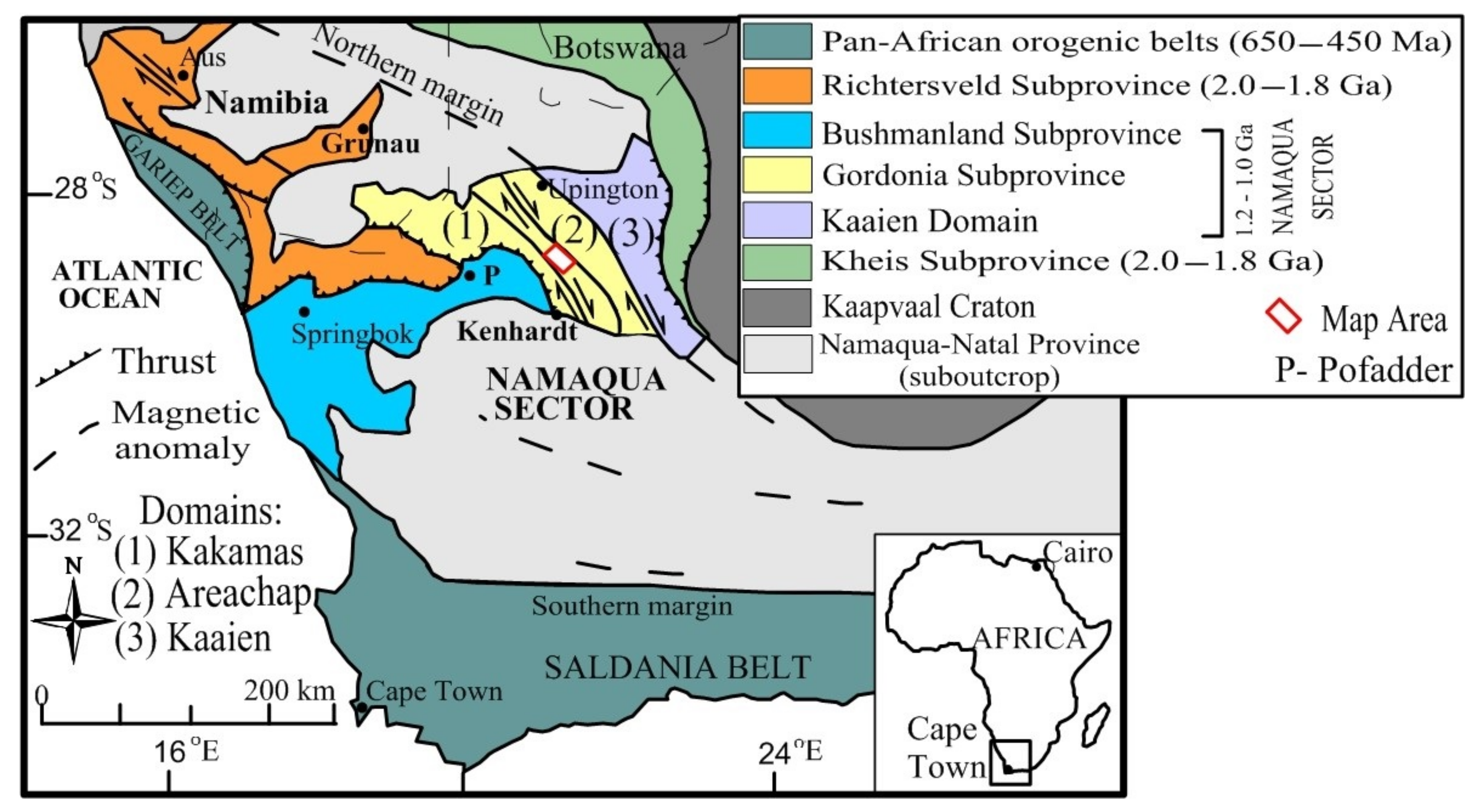
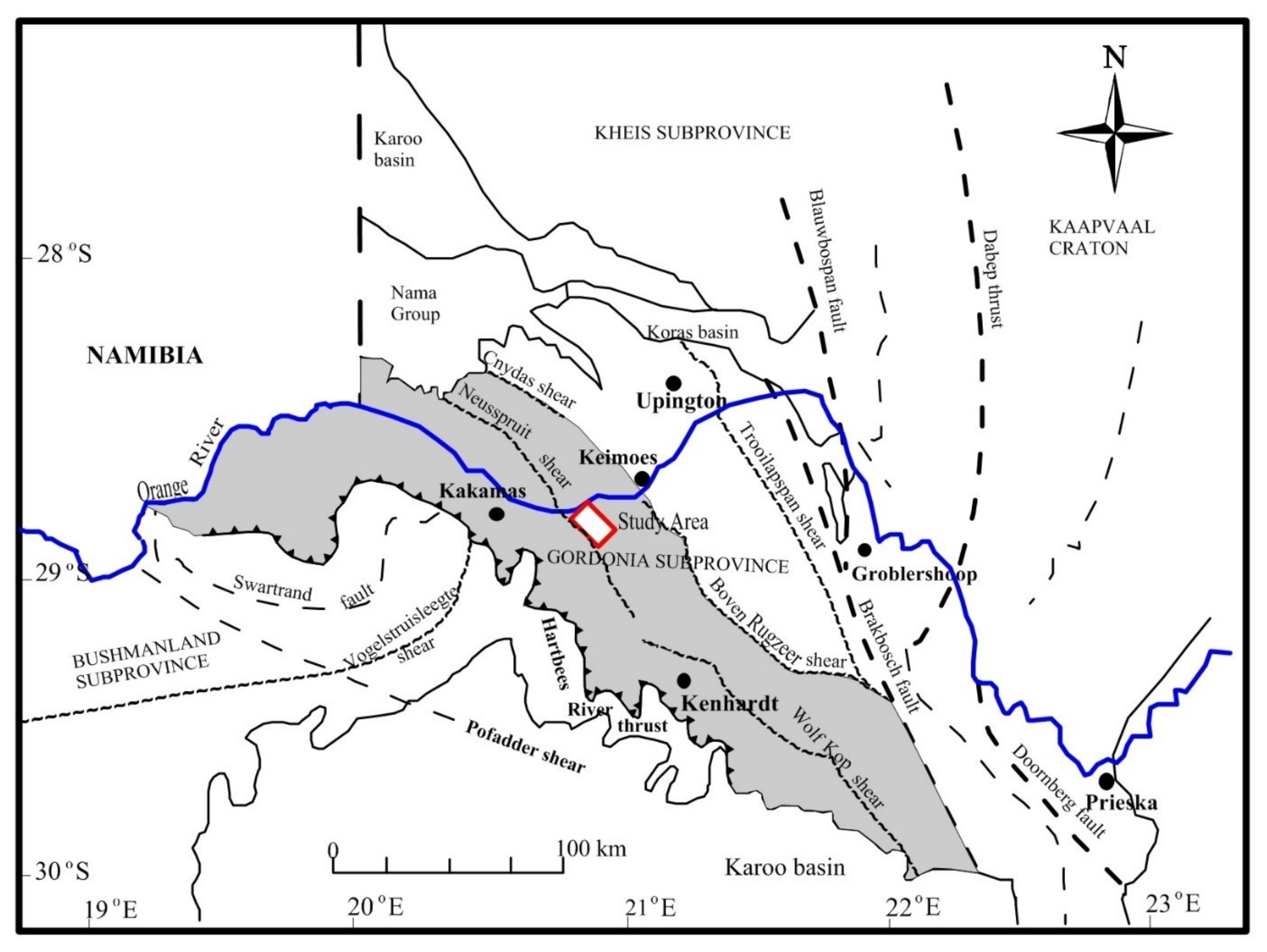
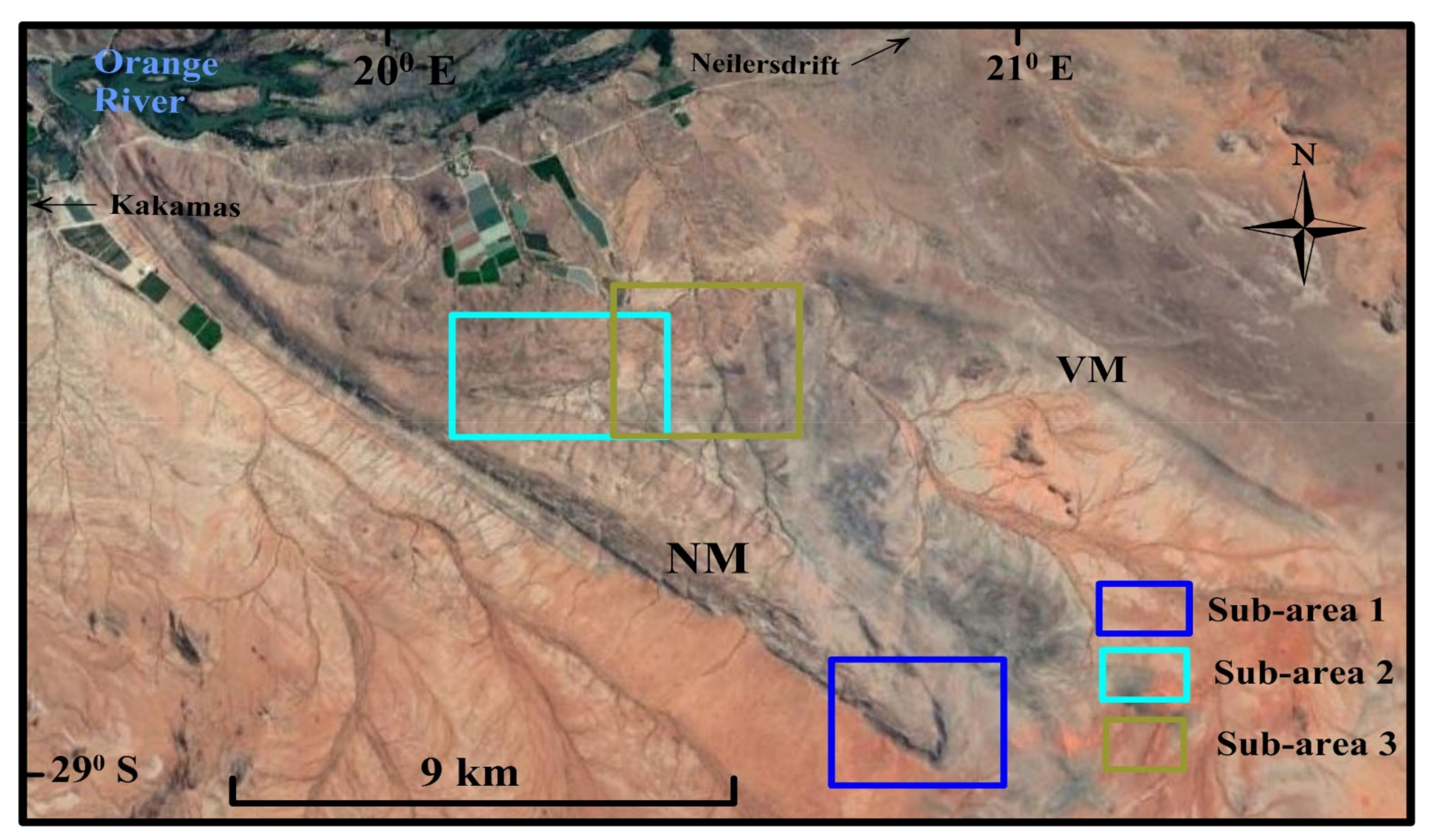
2. Geological Setting
3. Methodology
4. Results
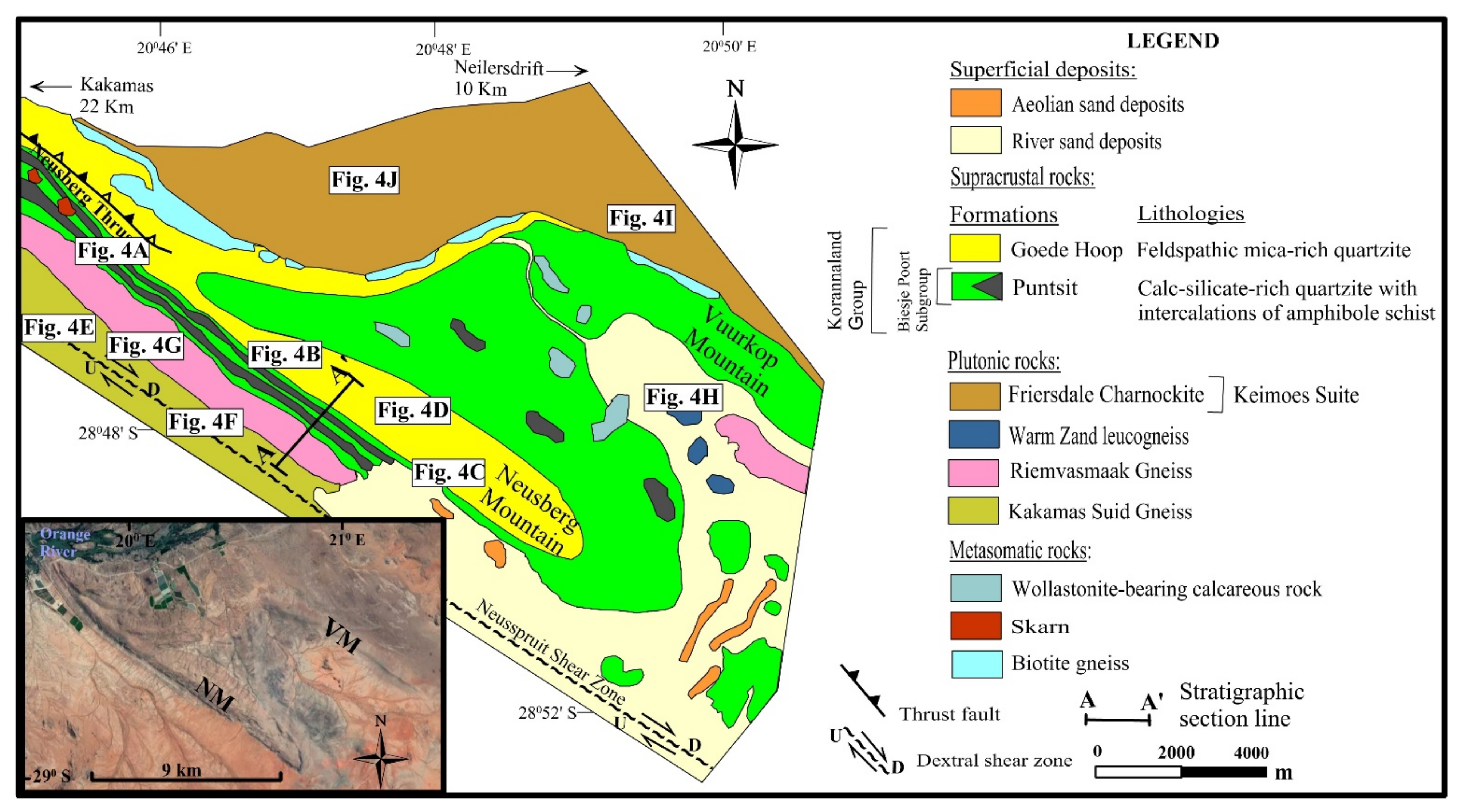
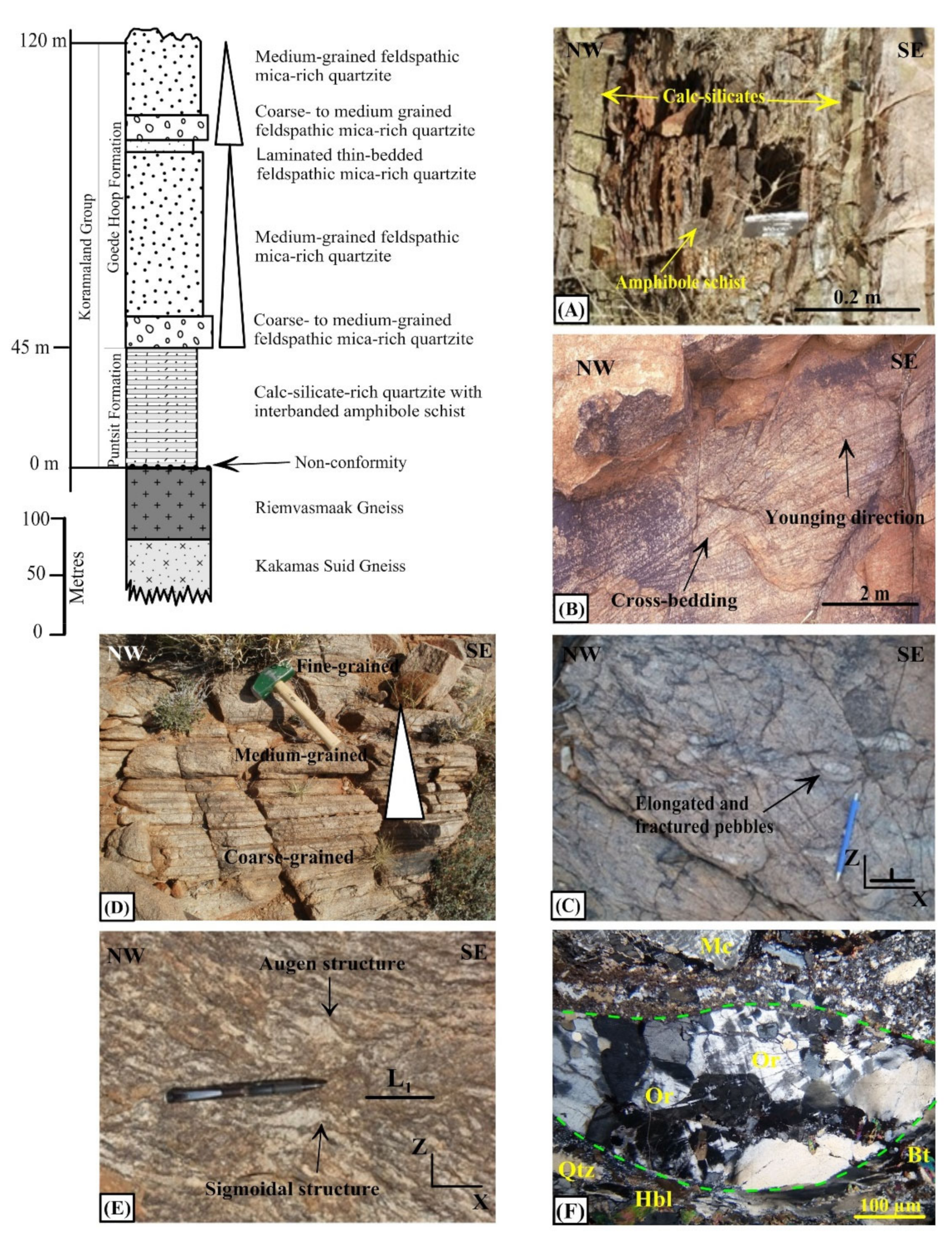
4.1. Lithostratigraphy
4.1.1. Supracrustal Rocks
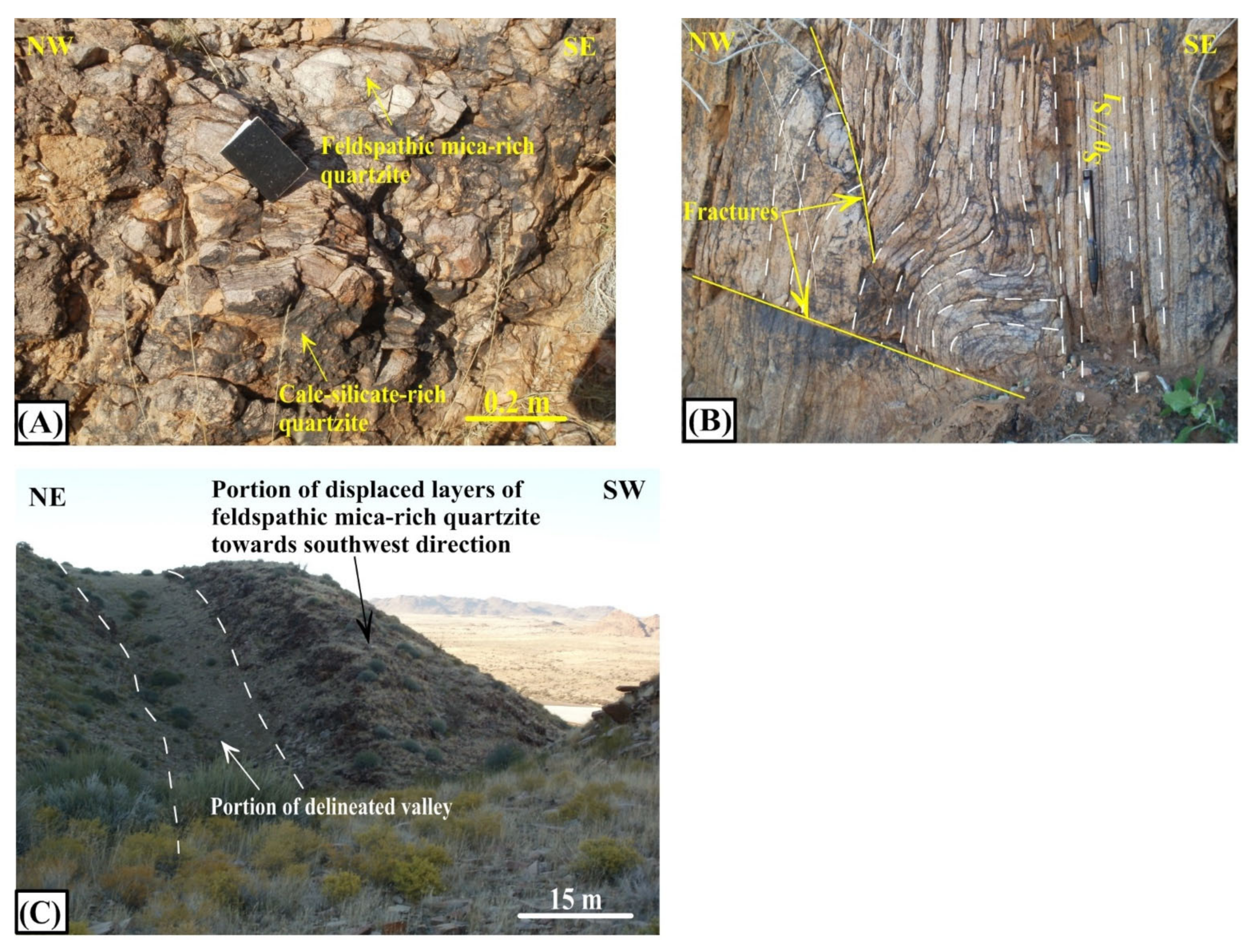
Puntsit Formation
Goede Hoop Formation
4.1.2. Plutonic Rocks
Basement
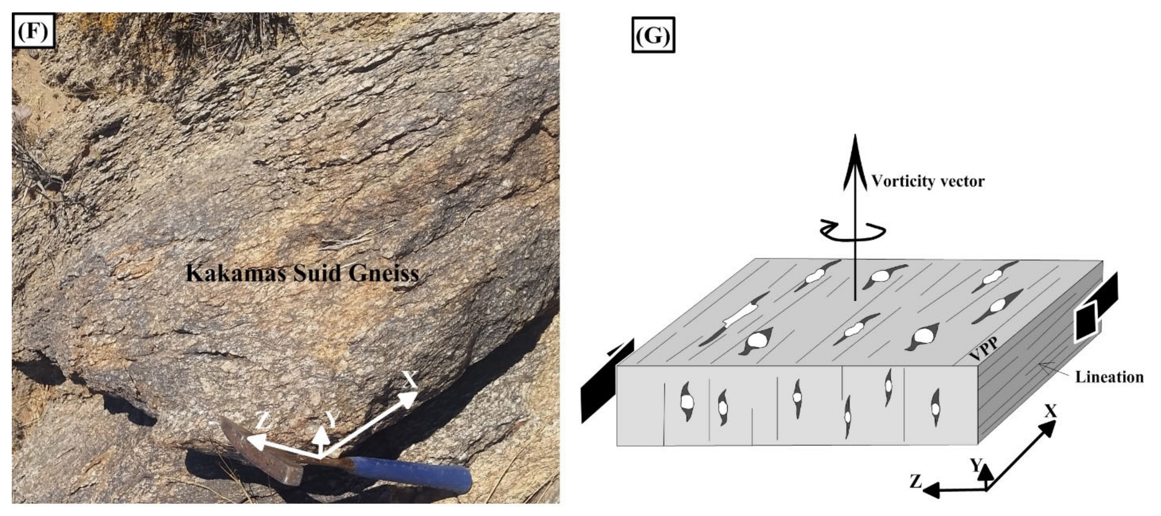
Kakamas Suid Gneiss
Riemvasmaak Gneiss
Warm Zand Leucogneiss
Friersdale Charnockite
4.2. Metamorphism
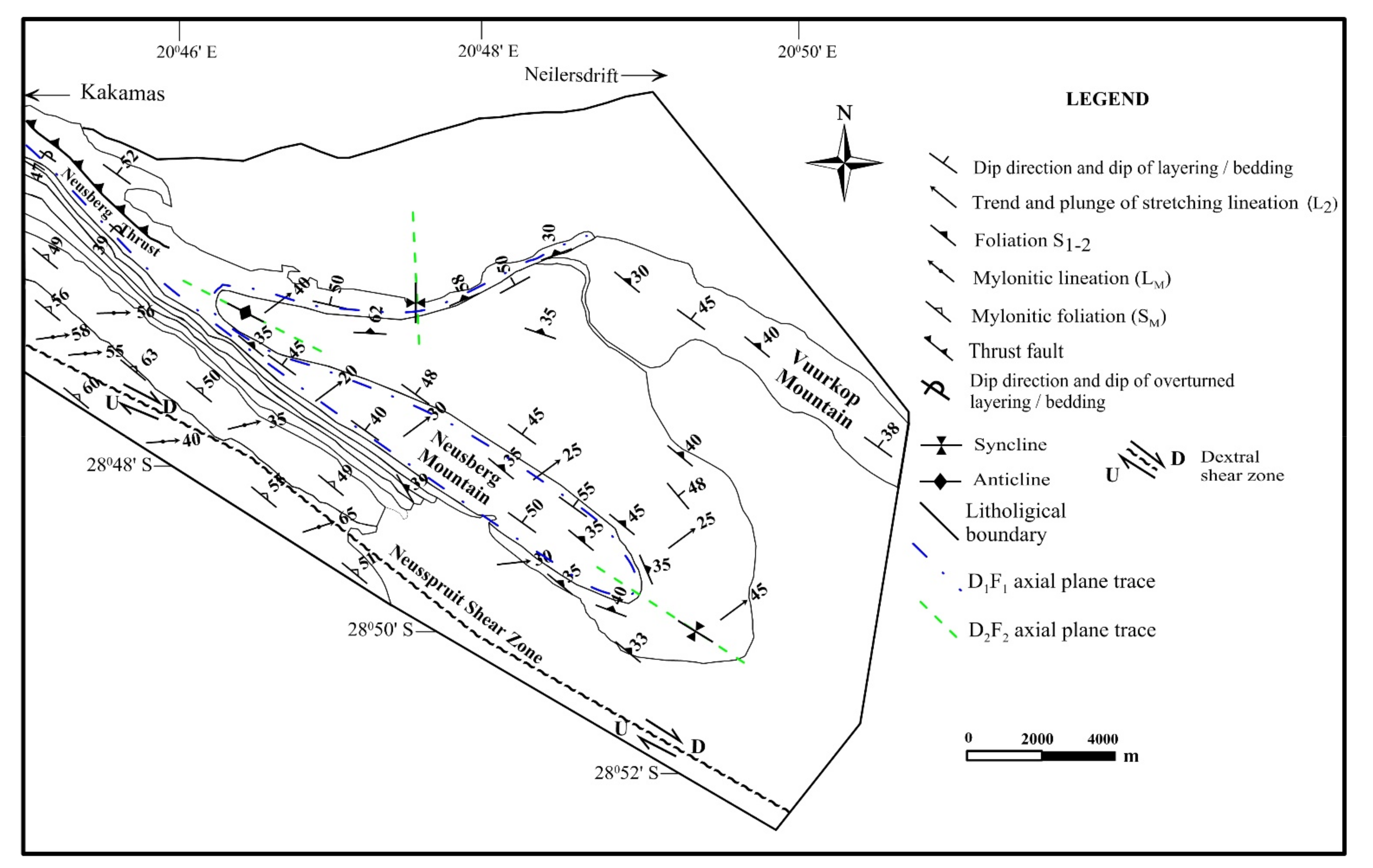
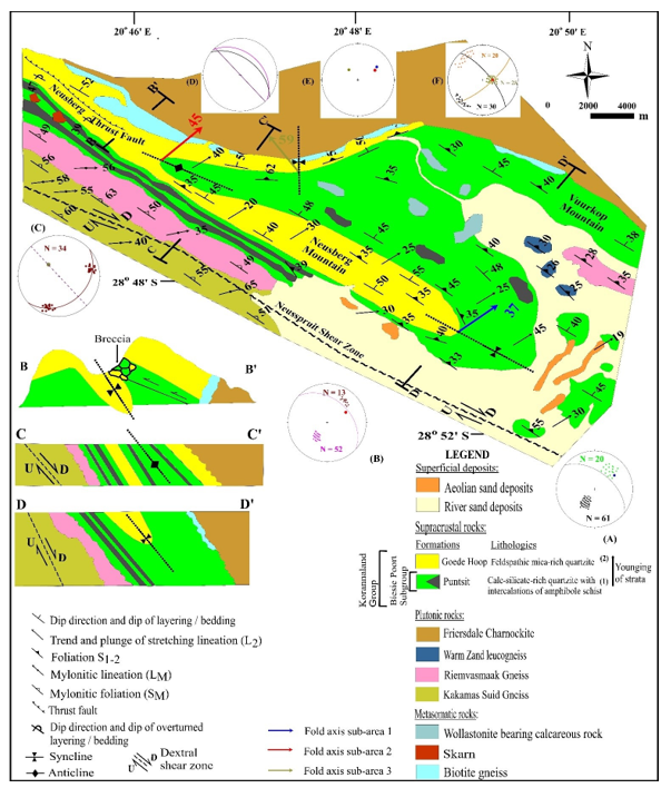
4.3. Structure
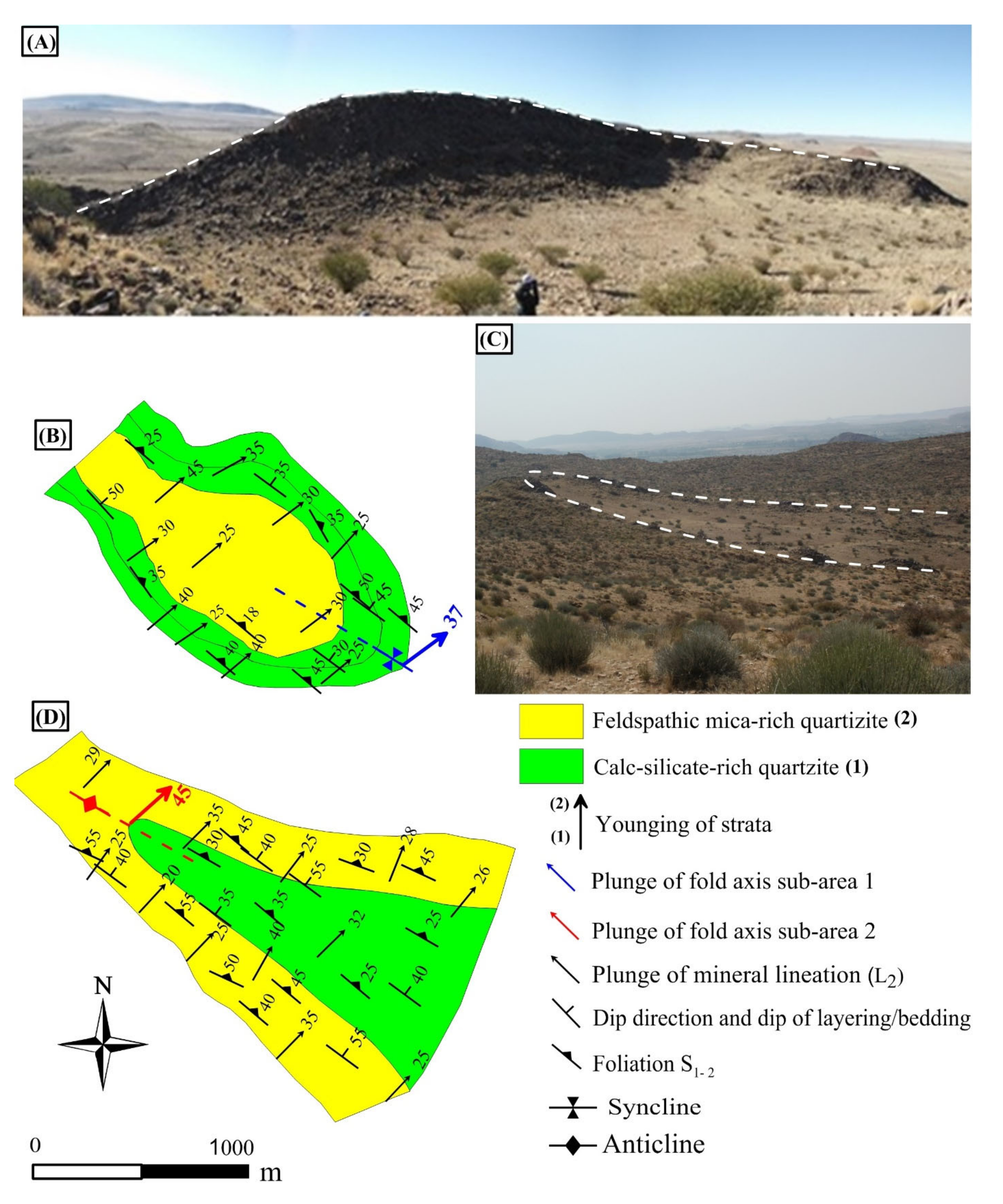
4.3.1. Neusberg Macrofold
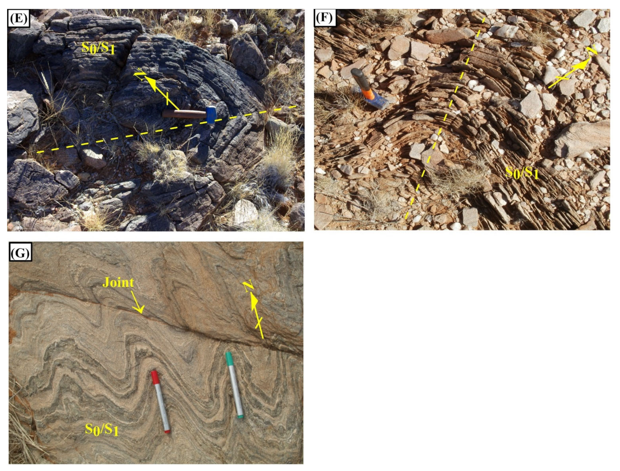
4.3.2. Structural Fabrics and Related Metamorphic Grade
Sub-Area 1
Sub-Area 2
Sub-Area 3
4.4. Thrusting
4.5. Shearing
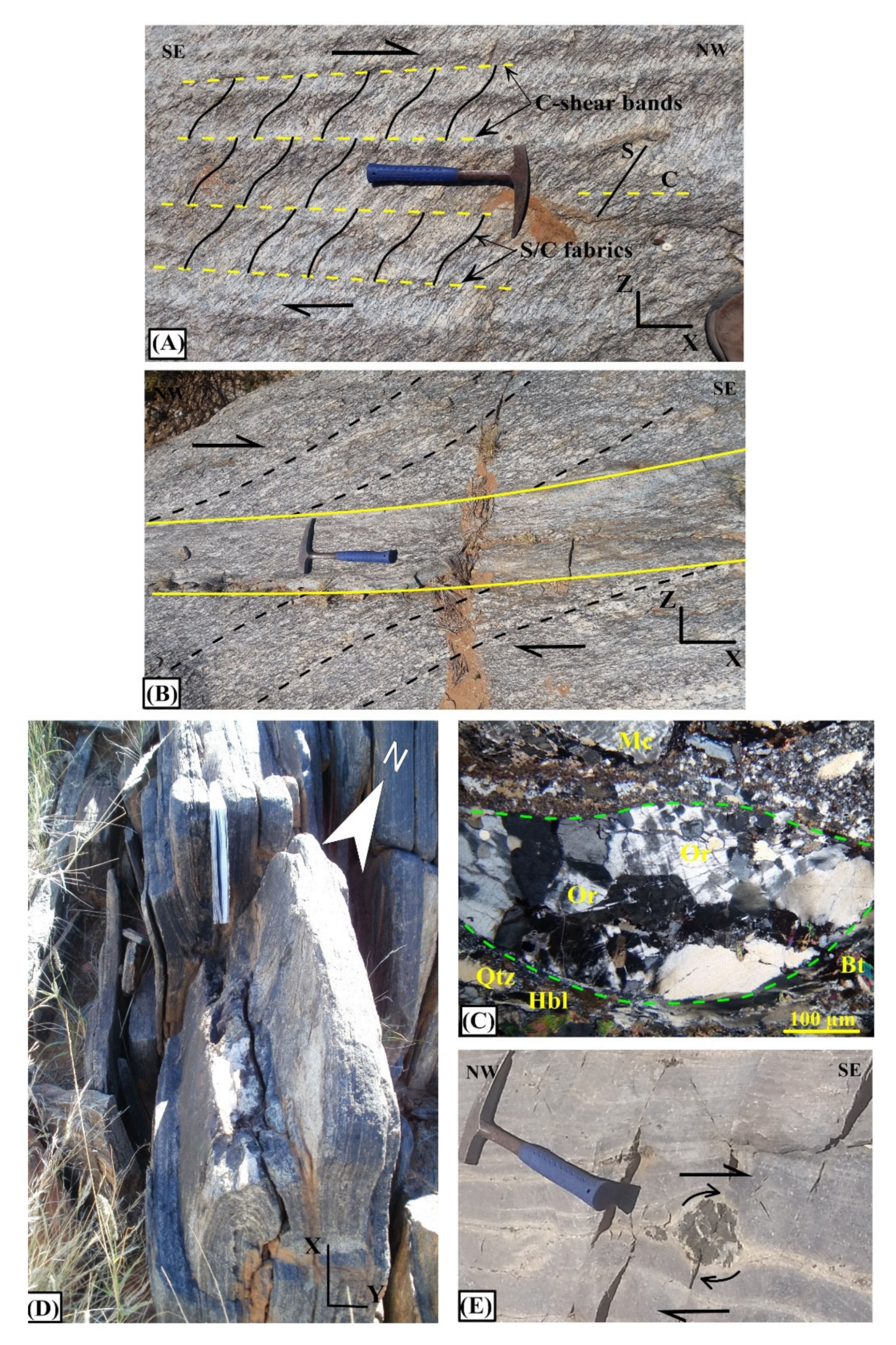
4.5.1. Shear Sense Indicators
4.5.2. Kinematic Analysis
5. Discussion
5.1. Basement/Cover Stratigraphy
5.2. Comparison of Sub-Areas
5.3. Metamorphism and Deformation
5.3.1. M1 and D1 Events
5.3.2. M2 and D2 Events
5.3.3. M3 and D3 Events
5.3.4. M4 and D4 Events
5.4. Tectonic Evolution
6. Conclusions
Supplementary Materials
Author Contributions
Funding
Data Availability Statement
Acknowledgments
Conflicts of Interest
References
- Colliston, W.P.; Schoch, A.E. Wrench-shearing during the Namaqua Orogenesis-a Mesoproterozoic window on late-phase deformation during Rodinia assembly. Precambr. Res. 2013, 233, 44–58. [Google Scholar] [CrossRef]
- Spencer, C.J.; Cawood, P.A.; Hawkesworth, C.J.; Prave, A.R.; Roberts, N.M.W.; Horstwood, M.S.A.; Whitehouse, M.J. Generation and preservation of continent crust in the Grenville Orogeny. Geosci. Front. 2015, 6, 357–372. [Google Scholar] [CrossRef] [Green Version]
- Macey, P.H.; Thomas, R.J.; Minnaar, H.M.; Gresse, P.G.; Lambert, C.W.; Groenewald, C.A.; Miller, J.A.; Indingo, J.; Angombe, M.; Shifotoka, G.; et al. Origin and evolution of the ~1.9 Ga Richtersveld Magmatic Arc, SW Africa. Precambr. Res. 2017, 292, 417–451. [Google Scholar] [CrossRef]
- Colliston, W.P.; Cornell, D.H.; Schoch, A.E.; Praekelt, H.E. Geochronological constraints on the Hartbees River Thrust and Augrabies Nappe: New insights into the assembly of the Mesoproterozoic Namaqua-Natal Province of Southern Africa. Precambr. Res. 2015, 265, 150–165. [Google Scholar] [CrossRef]
- Colliston, W.P.; Schoch, A.E.; Cole, J. The Grenvillian Namaqua fold belt adjacent to the western Kaapvaal Craton: 2. Archean Craton and supercontinent connections. Precambr. Res. 2017, 300, 289–314. [Google Scholar] [CrossRef]
- Mathee, H. Structural-Stratigraphic Investigation of an Area Near Kakamas and Environs, Namaqua Mobile Belt. Master’s Thesis, University of the Free State, Bloemfontein, South Africa, 2017. [Google Scholar]
- Jacobs, J.; Pisarevsky, S.; Thomas, R.J.; Becker, T. The Kalahari Craton during the assembly and dispersal of Rodinia. Precambr. Res. 2008, 160, 142–158. [Google Scholar] [CrossRef] [Green Version]
- Dalziel, I.W.; Mosher, S.; Gahagan, L.M. Laurentia-Kalahari Collision and the assembly of Rodinia. J. Geol. 2000, 108, 499–513. [Google Scholar] [CrossRef]
- Li, Z.X.; Bogdanova, S.V.; Collins, A.S.; Davidson, A.; De Waele, B.; Ernst, R.E.; Fitzsimons, I.C.W.; Fuck, R.A.; Gladkochub, D.P.; Jacobs, J.; et al. Assembly, configuration, and break-up history of Rodinia: A synthesis. Precambr. Res. 2008, 160, 179–210. [Google Scholar] [CrossRef]
- McLelland, J.M.; Selleck, B.W.; Bickford, M.E. Review of the Proterozoic evolution of the Grenville Province, its Adirondack outlier, and the Mesoproterozoic inliers of the Appalachians. Mem. Geol. Soc. Am. 2010, 206, 1–29. [Google Scholar]
- Hartnady, C.J.H.; Joubert, P.; Stowe, C.W. Proterozoic crustal evolution in southwestern Africa. Episodes 1985, 8, 236–244. [Google Scholar] [CrossRef] [Green Version]
- Thomas, R.J.; Cornell, D.H.; Moore, J.M.; Jacobs, J. Crustal evolution of the Namaqua-Natal metamorphic Province, southern Africa. S. Afr. J. Geol. 1994, 97, 8–14. [Google Scholar]
- Cornell, D.H.; Thomas, R.J.; Moen, H.F.G.; Reid, D.L.; Moore, J.M.; Gibson, R.L. The Namaqua-Natal Province. In The Geology of South Africa; Johnson, M.R., Anhaeusser, C.R., Thomas, R.J., Eds.; Geological Society of South Africa, Johannesburg/Council for Geoscience: Pretoria, South Africa, 2006; pp. 325–379. [Google Scholar]
- Miller, R. Review of Mesoproterozoic magmatism, sedimentation and terrane amalgamation in Southwestern Africa. S. Afr. J. Geol. 2012, 115, 417–448. [Google Scholar] [CrossRef]
- Colliston, W.P.; Schoch, A.E. Proterozoic metavolcanic rocks and associated metasediments along the Orange River in the Pofadder Terrane, Namaqua metamorphic belt. S. Afr. J. Geol. 1996, 99, 1–17. [Google Scholar]
- Moen, H. The Geology of the Upington Area. Map Sheet Explanation, 2820. Scale 1:250 000; Council for Geoscience: Pretoria, South Africa, 2007; p. 160. [Google Scholar]
- Coney, P.J.; Jones, D.L.; Monger, J.W.H. Cordilleran suspect terranes. Nature 1980, 288, 467–480. [Google Scholar] [CrossRef]
- Joubert, P. The Namaqualand Metamorphic Complex. In Precambrian of the Southern Hemisphere. Developments in Precambrian Geology 2; Hunter, D.R., Ed.; Elsevier: Amsterdam, The Netherlands, 1981; pp. 671–705. [Google Scholar]
- Blignault, H.J.; van Aswegen, G.; van der Merwe, S.W.; Colliston, W.P. The Namaqualand geotraverse and environs: Part of the Proterozoic Namaqua Mobile Belt. In Namaqualand Metamorphic Complex; Botha, B.V., Ed.; Special Publication of the Geological Society of South Africa: Johannesburg, South Africa, 1983; Volume 10, pp. 1–30. [Google Scholar]
- Cornell, D.H.; Pettersson, Å. Ion probe zircon dating of metasediments from the Areachap and Kakamas Terranes, Namaqua-Natal Province and the stratigraphic integrity of the Areachap Group. S. Afr. J. Geol. 2007, 110, 169–178. [Google Scholar] [CrossRef] [Green Version]
- Cornell, D.H.; Humphreys, H.; Theart, H.F.J.; Scheepers, D.J. A collision-related pressure-temperature-time path for Prieska Copper Mine, Namaqua-Natal tectonic Province, South Africa. Precambr. Res. 1992, 59, 43–71. [Google Scholar] [CrossRef]
- Cornell, D.H.; Pettersson, Å.; Simonsen, S.L. Zircon U-Pb emplacement and Nd-Hf crustal residence ages of the Straussburg granite and Friersdale Charnockite in the Namaqua-Natal Province, South Africa. S. Afr. J. Geol. 2012, 115, 465–484. [Google Scholar] [CrossRef]
- Joubert, P. The Namaqualand Complex-a model of Proterozoic accretion? Trans. Geol. Soc. S. Afr. 1986, 89, 79–96. [Google Scholar]
- Thomas, R.J.; von Veh, M.W.; McCourt, S. The tectonic evolution of southern Africa: An overview. J. Afr. Earth Sci. 1993, 16, 5–24. [Google Scholar] [CrossRef]
- Van Bever Donker, J. Structural and Metamorphic Evolution of an Area around Kakamas and Keimoes, Cape Province, South Africa; Bulletin of the Precambrian Research Unit, University of Cape Town 28: Cape Town, South Africa, 1980; p. 165. [Google Scholar]
- Van Bever Donker, J. The Neusspruit lineament, Upington geotraverse, possible boundary between the Namaqualand Metamorphic Complex and the Namaqua front. In Namaqualand Metamorphic Complex; Botha, B.J.V., Ed.; Special Publication of the Geological Society of South Africa: Johannesburg, South Africa, 1983; Volume 10, pp. 193–198. [Google Scholar]
- Van Bever Donker, J. A synthesis of the structural geology of a major tectonic boundary between a 1000 m.y. mobile belt and a 3000 m.y. craton. Tectonophysics 1991, 196, 359–370. [Google Scholar] [CrossRef]
- Colliston, W.P.; Praekelt, H.E.; Schoch, A.E. A progressive shear model for the Proterozoic Aggeneys Terrane, Namaqua mobile belt, South Africa. Precambr. Res. 1991, 49, 205–215. [Google Scholar] [CrossRef]
- De Beer, J.H.; Meyer, R. Geoelectrical and gravitational characteristics of the Namaqua-Natal mobile belt and its boundaries. In Namaqualand Metamorphic Complex; Botha, B.J.V., Ed.; Special Publication of the Geological Society of South Africa: Johannesburg, South Africa, 1983; Volume 10, pp. 91–100. [Google Scholar]
- De Beer, J.H.; Meyer, R. Geophysical characteristics of the Namaqua-Natal Belt and its boundaries. J. Geodynam. 1984, 1, 473–494. [Google Scholar] [CrossRef]
- Madi, K. Seismicity and neotectonic uplift in the Augrabies Falls National Park, Namaqualand, Northern Cape, South Africa. Earthquake Sci. 2016, 29, 281–289. [Google Scholar] [CrossRef] [Green Version]
- Eglington, B.M.; Armstrong, R.A. Geochronological and isotopic constraints on the Mesoproterozoic Namaqua-Natal Belt: Evidence from deep borehole intersections in South Africa. Precambr. Res. 2003, 125, 179–189. [Google Scholar] [CrossRef]
- Eglington, B.M. Evolution of the Namaqua-Natal Belt, southern Africa-a geochronological and isotope geochemical review. J. Afr. Earth Sci. 2006, 46, 93–111. [Google Scholar] [CrossRef]
- Armstrong, R.A.; de Wit, M.J. Armstrong, R.A.; de Wit, M.J. A summary of the geochronology and Precambrian crustal architecture of southern Africa, and possibilities for correlations with South America. In Problems in western Gondwana, Proceedings of South America-Africa correlations; Centro de Investigações do Gondwana: Gramado, Brazil, 2007; pp. 12–17. [Google Scholar]
- Bailie, R.; Gutzmer, J.; Rajesh, H.M. Age of ferroan post-tectonic granitoids of the southern part of the Keimoes Suite, Northern Cape Province, South Africa. J. Afr. Earth Sci. 2011, 60, 153–174. [Google Scholar] [CrossRef]
- Bailie, R.; Rajesh, H.M.; Gutzmer, J. Bimodal volcanism at the western margin of the Kaapvaal Craton in the aftermath of collisional events during the Namaqua-Natal Orogeny: The Koras Group, South Africa. Precambr. Res. 2012, 200, 163–183. [Google Scholar] [CrossRef]
- Bailie, R.; Macey, P.H.; Nethenzheni, S.; Frei, D.; Le Roux, P. The Keimoes Suite redefined: The geochronological and geochemical characteristics of the ferroan granites of the eastern Namaqua Sector, Mesoproterozoic Namaqua-Natal Metamorphic Province, southern Africa. J. Afr. Earth Sci. 2017, 134, 737–765. [Google Scholar] [CrossRef]
- Bial, J.; Büttner, S.H.; Frei, D. Formation and emplacement of two contrasting late-Mesoproterozoic magma types in the central Namaqua Metamorphic Complex (South Africa, Namibia): Evidence from Geochemistry and geochronology. Lithos 2015, 224, 272–294. [Google Scholar] [CrossRef]
- Colliston, W.P.; Schoch, A.E. Tectonostratigraphic features along the Orange River in the western part of the Mesoproterozoic Namaqua mobile belt. S. Afr. J. Geol. 1998, 101, 91–100. [Google Scholar]
- Colliston, W.P.; Schoch, A.E.; Praekelt, H.E. Stratigraphy of the Mesoproterozoic Aggeneys terrane, western Namaqua mobile belt, South Africa. S. Afr. J. Geol. 2012, 115, 449–464. [Google Scholar] [CrossRef]
- Von Backström, J. The Geology of an Area around Keimoes, Cape Province, with Special Reference to Phacoliths of Charnockitic Adamellite-Porphyry; Memoir of the Geological Survey of South Africa 53: Pretoria, South Africa, 1964; p. 218. [Google Scholar]
- Pettersson, Å.; Cornell, D.H.; Moen, H.F.G.; Reddy, S.; Evans, D. Ion-probe dating of 1.2 Ga collision and crustal architecture in the Namaqua-Natal Province of southern Africa. Precambr. Res. 2007, 158, 79–92. [Google Scholar] [CrossRef] [Green Version]
- Pettersson, Å. Mesoproterozoic Crustal Evolution in Southern Africa. Ph.D. Thesis, University of Gothenburg, Stockholm, Sweden, 2008. [Google Scholar]
- Slabbert, M.J.; Moen, H.F.G.; Agenbacht, A.L.D.; van der Merwe, S.W.; Siegfried, H.P. An. Introduction to the Proterozoic Rocks on the 1:250 000 Sheets 2820 Upington and 2920 Kenhardt. Pre-Summer Field School Guidebook; Geological Society of South Africa: Pretoria, South Africa, 1989; p. 90. [Google Scholar]
- Waters, D. Metamorphic zonation and thermal history of pelitic gneisses from western Namaqualand, South Africa. Trans. Geol. Soc. S. Afr. 1986, 89, 97–102. [Google Scholar]
- Waters, D.J. Thermal history and tectonic setting of the Namaqualand granulites, southern Africa: Clues to Proterozoic crustal development. In Granulites and Crustal Evolution; Vielzeuf, D., Vidal, P., Eds.; Kluver: Dondrecht, The Netherlands, 1990; pp. 243–256. [Google Scholar]
- Sandiford, M.; Martin, M.; Zhou, S.; Fraser, G. Mechanical consequences of granite emplacement during high-T, low-P metamorphism and the region of “anti-clockwise” PT paths. Earth Planet. Sci. Lett. 1991, 107, 164–172. [Google Scholar] [CrossRef]
- Bial, J.; Büttner, S.H.; Schenk, V.; Appel, P. The long-term high-temperature history of the central Namaqua Metamorphic Complex: Evidence for a Mesoproterozoic continental back-arc in southern Africa. Precambr. Res. 2015, 268, 243–278. [Google Scholar] [CrossRef]
- Bial, J.; Büttner, S.; Appel, P. Timing and conditions of regional metamorphism and crustal shearing in the granulite facies basement of south Namibia: Implications for the crustal evolution of the Namaqualand metamorphic basement in the Mesoproterozoic. J. Afr. Earth Sci. 2016, 123, 145–176. [Google Scholar] [CrossRef]
- Pederast, A.; von Backström, J.W. A study of an area at Kakamas. Trans. Geol. Soc. S. Afr. 1949, 52, 435–495. [Google Scholar]
- Lipson, R. Lithogeochemistry and Origin of Metasediments Hosting the Broken Hill Deposit, Aggeneys, South Africa, and Implications for Ore Genesis. Ph.D. Thesis, University of Cape Town, Cape Town, South Africa, 1990. [Google Scholar]
- McClung, C. Basin Analysis of the Mesoproterozoic Bushmanland Group of the Namaqua Metamorphic Province, South Africa. Ph.D. Thesis, University of Johannesburg, Johannesburg, South Africa, 2006. [Google Scholar]
- Bailie, R.; Armstrong, R.; Reid, D. The Bushmanland Group supracrustal succession, Aggeneys, Bushmanland, South Africa: Provenance, age of deposition and metamorphism. S. Afr. J. Geol. 2007, 110, 59–86. [Google Scholar] [CrossRef]
- Bailie, R.; Armstrong, R.; Reid, D. Composition and single zircon U–Pb emplacement and metamorphic ages of the Aggeneys Granite Suite, Bushmanland, South Africa. S. Afr. J. Geol. 2007, 110, 87–110. [Google Scholar] [CrossRef]
- Theart, H. Copperton-Areachap Cu, Zn Mineralization. Ph.D. Thesis, University of Stellenbosch, Stellenbosch, South Africa, 1985. [Google Scholar]
- Geringer, G.J.; Humphreys, H.C.; Scheepers, D.J. Lithostratigraphy, protolithology and tectonic setting of the Areachap Group along the eastern margin of the Namaqua mobile belt, South Africa. S. Afr. J. Geol. 1994, 97, 78–100. [Google Scholar]
- Bailie, R.; Gutzmer, J.; Rajesh, H. Lithogeochemistry as a tracer of the tectonic setting, lateral integrity and mineralisation of a highly metamorphosed Mesoproterozoic volcanic arc sequence on the eastern margin of the Namaqua Province, South Africa. Lithos 2010, 119, 345–362. [Google Scholar] [CrossRef]
- Diener, J. Low-P-high-T metamorphism of the Aggeneys terrane, Namaqua Metamorphic Complex, South Africa. S. Afr. J. Geol. 2014, 117, 31–44. [Google Scholar] [CrossRef]
- Diener, J.F.A.; White, R.W.; Link, K.; Dreyer, T.S.; Moodley, A. Clockwise, low-P metamorphism of the Aus granulite terrain, southern Namibia, during the Mesoproterozoic Namaqua Orogeny. Precambr. Res. 2013, 224, 629–652. [Google Scholar] [CrossRef]
- Stowe, C. The Upington Geotraverse and its implications for craton margin tectonics. In Namaqualand Metamorphic Complex; Botha, B.J.V., Ed.; Special Publication of the Geological Society of South Africa: Johannesburg, South Africa, 1983; Volume 10, pp. 147–171. [Google Scholar]
- Humphreys, H.C.; van Bever Donker, J.M. Early Namaqua low-pressure metamorphism: Deformation and porphyroblast growth in the Zoovoorby staurolite schist, South Africa. J. Metam. Geol. 1990, 8, 159–170. [Google Scholar] [CrossRef]
- Stowe, C. Synthesis and interpretation of structures along the north-eastern boundary of the Namaqua Tectonic Province, South Africa. Trans. Geol. Soc. S. Afr. 1986, 89, 185–198. [Google Scholar]
- Praekelt, H. Die geologie van die gebied rondom Augrabies (2820 C.). Master’s Thesis, University of the Orange Free State, Bloemfontein, South Africa, 1984. [Google Scholar]
- Büttner, S.H.; Fryer, L.; Lodge, J.; Diale, T.; Kazondunge, R.; Macey, P.M. Controls of host rock mineralogy and H2O content on the nature of pseudotachylyte melts: Evidence from Pan-African faulting in the foreland of the Gariep Belt, South Africa. Tectonophysics 2013, 608, 552–575. [Google Scholar] [CrossRef]
- Moen, H. Petrology of the Wilgenhoutsdrif Group; Bulletin of the Geological Survey of South Africa 89: Pretoria, South Africa, 1988; p. 37. [Google Scholar]
- Allmendinger, R.W.; Cardozo, N.C.; Fisher, D. Structural Geology Algorithms: Vectors and Tensors; Cambridge University Press: Cambridge, UK, 2013; p. 289. [Google Scholar]
- Fleuty, M. The description of folds. Proceed. Geol. Assoc. 1964, 75, 461–492. [Google Scholar] [CrossRef]
- Geringer, G. The Geology of the Archaean Rocks and Younger Formations in the Area to the West of Upington with Special Reference to Various Occurrences of Granite. Ph.D. Thesis, University of the Orange Free State, Bloemfontein, South Africa, 1973. [Google Scholar]
- Thomas, R.J.; Macey, P.H.; Spencer, C.; Dhansay, T.; Diener, J.F.A.; Lambert, C.W.; Frei, D.; Nguno, A. The Sperrgebiet domain, Aurus Mountains, SW Namibia: A 2020-850 Ma window within the Pan-African Gariep orogen. Precambr. Res. 2016, 236, 35–58. [Google Scholar] [CrossRef]
- Barton, E.S.; Burger, A.J. Reconnaissance isotopic investigations in the Namaqua mobile belt and implications for Proterozoic crustal evolution-Upington geotraverse. In Namaqualand Metamorphic Complex; Botha, B.J.V., Ed.; Special Publication of the Geological Society of South Africa: Johannesburg, South Africa, 1983; Volume 10, pp. 173–192. [Google Scholar]
- Janney, P.E.; Shirey, S.B.; Carlson, R.W.; Pearson, D.G.; Bell, D.R.; Le Roex, A.P.; Ishikawa, A.; Nixon, P.H.; Boyd, F.R. Age, composition and thermal characteristics of South African off-craton mantle lithosphere: Evidence for a multi-stage history. J. Petrol. 2010, 51, 1849–1890. [Google Scholar] [CrossRef]
- Pettersson, Å.; Cornell, D.H.; Yuhara, M.; Hirahara, Y. Sm-Nd data for granitoids across the Namaqua-Natal Province, South Africa. Geol. Soc. Lond. Spec. Publ. 2009, 323, 219–230. [Google Scholar] [CrossRef]
- Ramsay, J. Shear zone geometry: A review. J. Struct. Geol. 1980, 2, 83–99. [Google Scholar] [CrossRef]
- Ramsay, J.G.; Huber, M.I. The Techniques of Modern Structural Geology. Volume 1: Strain Analysis; Academic Press: London, UK, 1983; p. 307. [Google Scholar]
- Stowe, C. Preliminary Report on Geodynamics in the Upington Geotraverse; Annual Report, Precambrian Research Unit, University of Cape Town: Cape Town, South Africa, 1980; Volume 24–48, p. 17. [Google Scholar]
- Passchier, C.W.; Trouw, R.A.J. Microtectonics, 2nd ed.; Springer: Berlin, Germany, 2005; p. 371. [Google Scholar]
- Passchier, C.W.; Coelho, S. An outline of shear-sense analysis in high-grade rocks. Gondwana Res. 2006, 10, 66–76. [Google Scholar] [CrossRef]
- Oriolo, S.; Wemmer, K.; Oyhantcabal, P.; Fossen, H.; Schulz, B.; Siegesmund, S. Geochronology of shear zones-A review. Earth-Sci. Rev. 2018, 185, 665–683. [Google Scholar] [CrossRef]
- Robin, P.Y.F.; Cruden, A.R. Strain and vorticity patterns in ideally ductile transpression zones. J. Struct. Geol. 1994, 16, 447–466. [Google Scholar] [CrossRef]
- Passchier, C. Monoclinic model shear zones. J. Struct. Geol. 1998, 20, 1121–1137. [Google Scholar] [CrossRef]
- Jacobs, J.; Thomas, R.J.; Weber, K. Accretion and indentation tectonics at the southern edge of the Kaapvaal craton during the Kibaran (Grenville) orogeny. Geology 1993, 21, 203–206. [Google Scholar] [CrossRef]
- Clifford, T.N.; Barton, E.S.; Stern, R.A.; Duchesne, J.-C. U-Pb zircon calendar for Namaquan (Grenville) crustal events in the granulite-facies terrane of the O’okiep Copper District of South Africa. J. Petrol. 2004, 45, 669–691. [Google Scholar] [CrossRef] [Green Version]


| Group | Subgroup | Suite | Formation/Nature | Member/Unit | Rock Type | Age (Ma) | Thickness (m) | Description |
|---|---|---|---|---|---|---|---|---|
| Keimoes | Friersdale Charnockite | Intrusive rock | 1113–1080 | Opalescent blue quartz, lenses of felsic and mafic composition, medium- to coarse-grained, granoblastic texture | ||||
| Non-conformity | ||||||||
| Korannaland | Goede Hoop (Fluviatile) | Feldspathic mica-rich quartzite | Supracrustal rock | 140–200 | Medium to coarse-grained quartzite, granoblastic texture, well-bedded, presence of pebbles, extensively intruded by Friersdale Charnockite, biotite gneiss within the contact zone | |||
| Biesie Poort | Puntsit (psammitic and calcareous with intercalations of likely basaltic material) | Calc-silicate-rich quartzite with intercalations of amphibole schist | 30–80 | Fine- to medium-grained quartzite, granoblastic texture, presence of intercalations of fine-grained amphibole schist, well-bedded, lenses of skarn and wollastonite-bearing calcareous rock | ||||
| Non-conformity | ||||||||
| Warm Zand leucogneiss | Intrusive rock | Brown in colour, fine- to medium-grained, quartz and feldspar, faint streaks of amphibole and biotite, granoblastic texture | ||||||
| Riemvasmaak Gneiss | Pink in colour, medium- to coarse-grained, quartz and feldspar, amphibole and biotite, granoblastic texture | |||||||
| Kakamas Suid Gneiss | Grey to brown in colour, augen texture, feldspar mylonites, inequigranular showing augen texture | |||||||
| Deformation Event | Age (Ma) | Magmatism | Metamorphism | Structure | Characteristic | Fabric | Deformation Style |
|---|---|---|---|---|---|---|---|
| D1a | ~1200 | a T = ~800 °C P = 5.5 kbar | Inter-terrane thrust (HBRT) | Compressional deformation | start of progressive shear | ||
| D1b | F₁ folding | D₁bF₁ folds, transposition S₀ into S₁ | S₁ shear fabric | progressive shear continuing | |||
| D2 | ~1155–1110 | Syn-tectonic plutons | b T = 700–660 °C P = 5.5 kbar | F₂ folding | D₁bF1 folds, S2 axial planar, S₁/S₂ co-planar | S₂ regional fabric | Main progressive shear |
| D3 | c 1113 to 1080 | Post-tectonic Friersdale Charnockite of the Keimoes Suite | d T = ~640–550 °C P = 4.8 kbar | Friersdale Charnockite into D₁b fold hinge | Weakly defined fabric | Progressive shear terminated | |
| D4 | e T = ~350 °C P = ~3.5 kbar | Reactivation of intra-terrane thrust, formation of transcurrent shear zone | Northwest-trending steeply inclined shear zone, shear direction towards east | Deformation of adjacent pre-existing structure | Start of transpressional shearing |
Publisher’s Note: MDPI stays neutral with regard to jurisdictional claims in published maps and institutional affiliations. |
© 2021 by the authors. Licensee MDPI, Basel, Switzerland. This article is an open access article distributed under the terms and conditions of the Creative Commons Attribution (CC BY) license (https://creativecommons.org/licenses/by/4.0/).
Share and Cite
Tsakou Sonwa, C.S.; van Bever Donker, J.; Bailie, R. Polyphase Deformation of the High-Grade Metamorphic Rocks along the Neusspruit Shear Zone in the Kakamas Domain: Insights into the Processes during the Namaquan Orogeny at the Eastern Margin of the Namaqua Metamorphic Province, South Africa. Minerals 2021, 11, 759. https://doi.org/10.3390/min11070759
Tsakou Sonwa CS, van Bever Donker J, Bailie R. Polyphase Deformation of the High-Grade Metamorphic Rocks along the Neusspruit Shear Zone in the Kakamas Domain: Insights into the Processes during the Namaquan Orogeny at the Eastern Margin of the Namaqua Metamorphic Province, South Africa. Minerals. 2021; 11(7):759. https://doi.org/10.3390/min11070759
Chicago/Turabian StyleTsakou Sonwa, Cyrille Stephane, Jan van Bever Donker, and Russell Bailie. 2021. "Polyphase Deformation of the High-Grade Metamorphic Rocks along the Neusspruit Shear Zone in the Kakamas Domain: Insights into the Processes during the Namaquan Orogeny at the Eastern Margin of the Namaqua Metamorphic Province, South Africa" Minerals 11, no. 7: 759. https://doi.org/10.3390/min11070759