Article

The Miedzianka Mountain Ore Deposit (Świętokrzyskie Mountains, Poland) as a Site of Historical Mining and Geological Heritage: A Case Study of the Teresa Adit

1
Geology Department, Institute of Geography, Pedagogical University of Krakow, Podchorążych 2, 30-084 Kraków, Poland
2
Okręgowy Urząd Górniczy w Kielcach, Wrzosowa 44, 25-211 Kielce, Poland
3
LafargeHolcim, Al. Jerozolimskie 142 B, 02-305 Warszawa, Poland
*
Author to whom correspondence should be addressed.
Minerals 2021, 11(11), 1177; https://doi.org/10.3390/min11111177
Submission received: 15 September 2021 / Revised: 19 October 2021 / Accepted: 20 October 2021 / Published: 24 October 2021
(This article belongs to the Special Issue The Role of Minerals in Cultural and Geological Heritage)

Abstract

:
There are numerous traces of mining activity in the Miedzianka Mountain (Świętokrzyskie Mountains, Poland), because copper and silver ores have been mined in this region since at least the 13th century. The history of scientific research on the Miedzianka Mountain ore deposit spans almost 200 years. Almost 40 minerals have been found: ore minerals of Cu and Fe, and also secondary minerals, including carbonates, sulphates and even very rare arsenates, phosphates and vanadates. Three new minerals have been found, staszicite, lubeckite and miedziankite, but their chemical composition has not been precisely determined and therefore their names have not been approved by the International Mineralogical Association (IMA). The Miedzianka Mountain deposit is an important area on the map of educational activities. It is included in the “Świętokrzyskie Archaeological and Geological Trail” as a site of historical (mining and metallurgy) and natural (geological sciences) heritage. Despite the large potential, none of the underground workings (adits and shafts) are currently available to the public. Our research and exploration of the Teresa adit, which is one of the historical underground complexes of the Miedzianka Mountain, show that this adit displays a wide spectrum of topics in the field of mineralogy, geology and mining history. The Teresa adit, which is a 523 m system of underground corridors, contains 270 m of natural karst caves altered by mining works and is constituted of Upper Devonian limestones, locally cut by cherry shales. In several sites of the adit unique features can be observed, such as: (1) old mining works—galleries carved in the rock back in the 19th century; (2) interesting vein mineralization with secondary-colored copper carbonates and multi-colored calcite veins; (3) mineralization with azurite domination; and (4) karst phenomena (coatings, flowstone, dripstones and stalactites) in a cave part of the adit. The sites with unique features suggest that the Teresa adit is highly suitable to be presented to tourists. That is why we propose seven sites on the underground route that could be the basis for further projects to create a “geotouristic trail” in the Teresa adit. The proposal to make the Teresa adit available to tourists is in line with the tendency to protect the post-industrial landscape associated with former mining activities.

1. Introduction

The term geological heritage (or geoheritage) is used to describe natural geological features or geomorphological forms that are distinguished by aesthetic, scientific and educational values. Due to such objects, we can learn about dynamic geological processes that influence the evolution of the Earth and its geodiversity. Geological objects that are related to human activities, such as mining, can be referred to as geological heritage as well as cultural heritage. The original concept of geoheritage also included the protection of dynamic geological processes and geodiversity. The definition and term geological heritage or geoheritage has evolved since the 1980s [1,2,3,4,5,6,7]. The most recent update of the concept of geoheritage concerns the planetary (space) geology of vertical destinations [8]. The Świętokrzyskie Mountains (southeastern part of Poland) are known for the occurrence of lead ores, copper, silver and also gold, as well as rock resources (e.g., so-called “Świętokrzyskie marbles”) [9,10,11,12,13]. Many of these ore deposits are examples of unique sites with geological, mineralogical, mining, historical and archeological heritage. One very interesting example is the Miedzianka Mountain, which is a massif in the southwestern part of the Świętokrzyskie Mountains. The history of copper mining in the Miedzianka Mountain probably began in the Bronze Age, dated at 1800–700 B.C. [14]. The first written documents regarding the exploitation of ore deposits date back to the 13th century [14]. The Miedzianika Mountain concerning numerous traces of old mining activity, such as partially collapsed and flooded adits, shafts, underground excavations, heaps and queries exist. Geology, mineralization and the history of mining in the Miedzianka Mountain has been described in many papers since the 18th century, e.g., [11,12,14,15,16,17,18,19,20,21,22,23,24,25]. Since the 1950’s, the Miedzianka Mountain has been established as the Miedzianka Mountain Reserve in order to protect the remains of mining activity in this area. The Miedzianka Mountain is one of the sites on the “Świętokrzyskie Archaeological and Geological Trail”, created in 2011. It is also included in a proposed project entitled the “Establishment of the Old Polish District of Ore Mining in Miedzianka”. This project includes providing access to the underground galleries of historical adits in the Miedzianka Mountain deposit [15]. It mainly focuses on developing a safe route for visiting, as well as technical documentation (e.g., electrical installation, sound system, strengthen of side walls and roof, etc.) [15].
The aim of our work is to present the geological, educational and cultural heritage of mining in the Miedzianka Mountain deposit via the example of research on one of the underground adits, called the Teresa adit. The Teresa adit was operated as a mine in the beginning of the 19th century. It is partially a natural cave, and underground galleries formed during mining activities. So far, this adit has been mentioned in the literature [12,26,27]. However, it has not been thoroughly researched in terms of science, and there is no publication describing geotouristic values. In this paper, we present the results of our geological study of the Teresa adit. We explored the underground space and collected representative samples of minerals and rocks. We have described the most representative sites where there are clearly visible records of some ore deposit mineralization and geological processes (tectonics and karst), which are hardly observed on the surface in quarries as well as heaps, e.g., [25]. We also discuss the geotouristic potential of the Teresa adit.

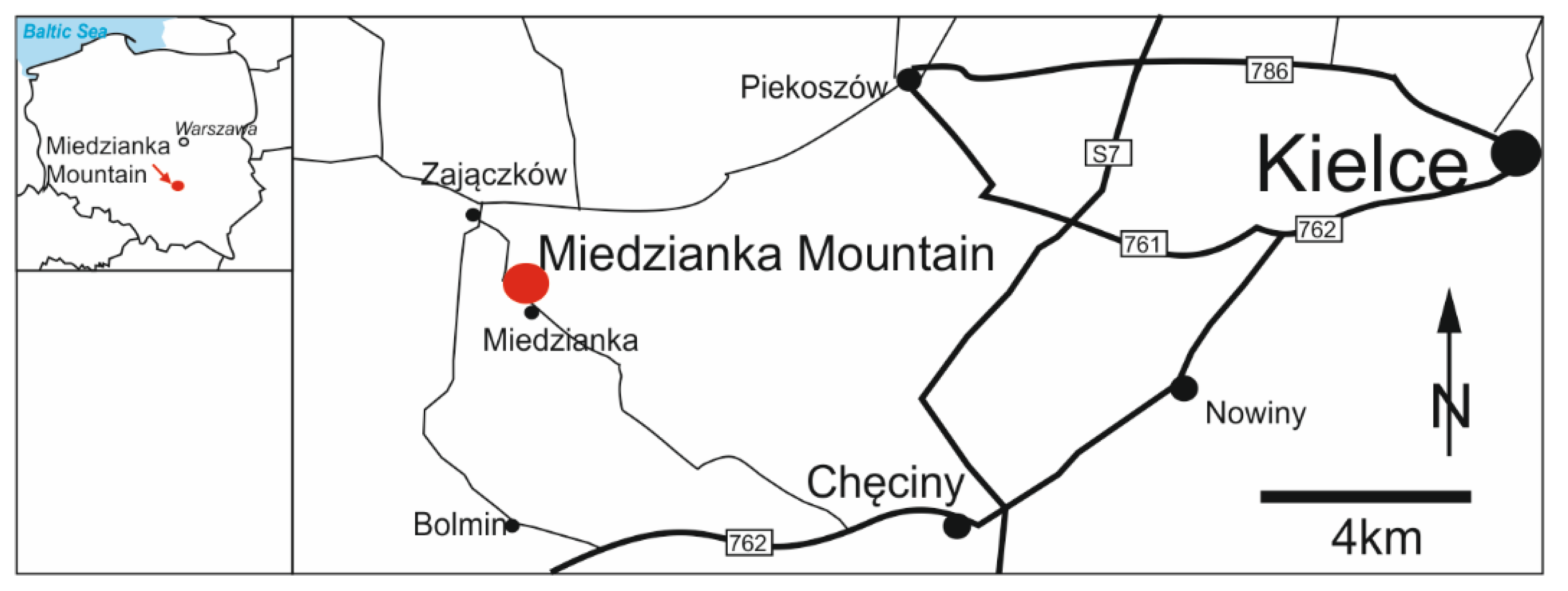
2. Miedzianka Mountain Location

The Miedzianka Mountain is located in the southeastern part of Poland, about 20 km west of Kielce (Figure 1). The Miedzianka Mountain is a massif in the southwestern part of the Świętokrzyskie Mountains, in the northwest end of the Chęciński range. It consists of two rocky peaks: the eastern one—the highest one—is 354 m above sea level, and the second—the western one—is slightly lower, at 350 m above sea level. At the foot of the Miedzianka Mountain there is Miedzianka, a village.

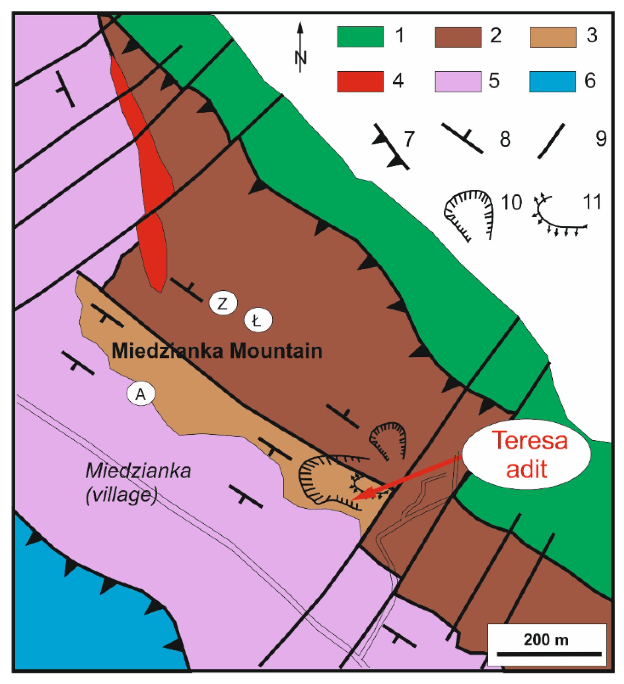
3. Geological Setting of the Miedzianka Mountain

The Miedzianka Mountain is constituted of Middle (Givetian) and Upper (Frasnian–Famennian) Devonian limestones [21,29,30,31,32,33,34,35] (Figure 2). They are mainly represented by massive stromatoporoid–coral limestones. The thickness of these limestones is estimated to be from 330–800 m [33]. Locally, the marly shales and marly limestones deposits of the Famennian are observed as a thin, deformed and tectonically wedged intercalations (e.g., SE slope). The limestone deposits represent the shallow carbonate platform environment in the zone of dynamic sedimentation of bioclastic material [34,35]. They are evidence of the sinking of the carbonate shelf during transgression from the Givetian to the Famennian. The foothills from the southern and western parts of the slope are built of Triassic deposits, represented by Buntsandstein sandstones and clays and Rhaetian clay and limestone (Figure 2). On the western slopes of the Miedzianka Mountain, on Devonian limestones, there are several isolated patches of Permian conglomerates.
The Miedzianka Mountain area is a highly complex tectonic structure. It belongs geologically to the Paleozoic core of the Świętokrzyskie Mountains. The Miedzianka Mountain is located in the Kielce fold zone and constitutes the southern wing of the Chęciny anticline. Devonian limestones fall both to the south and to the north directions (Figure 2). Deposits that build the Miedzianka Mountain are shifted towards the northeast on strongly folded Lower Cambrian deposits that belong to the core part of the Chęciny anticline [36]. To the southwest, the Triassic deposits of the Mesozoic cover of the Świętokrzyskie Mountains lie on Devonian limestones. Southwest of the hill, the Jurassic limestones are overlapped by the Triassic deposits (Figure 2). The Miedzianka Mountain is cut with numerous faults. There are two main systems of dislocations on the Miedzianka Mountain: longitudinal and transverse faults [37]. The longitudinal faults are the older ones, pre-Triassic (time of Variscan orogenic movement), with the direction coinciding with the axis of the Chęciny anticline. The longitudinal faults cut only the Paleozoic deposits. The transverse faults are younger—post-Triassic, likely post-Jurassic—and their direction is transverse to the extent of the Paleozoic deposits (Figure 2).
The tectonically complex structure of Miedzianka Mountain is caused by two superimposed orogeneses [31,37]. First, the Variscan orogenesis in the Late Carboniferous when the Palaeozoic core in the Miedzianka Mountain was folded. The second is the Alpine orogeny (during the Laramian phase), when the Paleozoic core was tectonically rejuvenated. During these movements, the Mesozoic deposits pressed against the Paleozoic formations of the Chęciny anticline, causing a reverse overthrow of Devonian limestones in the Miedzianka Mountain. Devonian sediments were detached from the bedrock and thrust over the Cambrian sediments, located in the Chęciny anticline [31].
Ore Deposits in the Miedzianka Mountain
Mineralogical and geochemical research on the Miedzianka Mountain has been carried out since the 19th century up to the present day, e.g., [11,14,16,17,18,19,21,24,25,38,39,40,41,42]. A total of 40 minerals have been discovered so far in Miedzinka Mountain ore deposits [11]. Copper ore deposits are connected with the complicated tectonics of the Miedzianka Mountain. Mineralization developed mainly in the network of longitudinal cracks and faults with azimuths within 130–145 degrees (the main workings also have a similar course) [21].
There are two main types of deposit concentrations of copper minerals in the Miedzianka Mountain: primary and secondary ore deposits [21].
Primary ore deposits include copper sulfide minerals, mainly goldish chalcopyrite, chalcocite and black tennantite, as well as other minerals represented by galena, hematite, calcite, barite and quartz [24,38,39]. They are situated in veins and tectonic breccia cutting the Devonian limestones. They are concentrated mainly in the longitudinal tectonic zones associated with the Variscan tectonics, which do not cross the Triassic sandstone rocks anywhere. The primary ore deposits are detected in the lower parts of the Devonian limestones, approximately at a depth of less than 230 m above sea level. The origin of these deposits are explained as a result of the migration of heated, highly mineralized hydrothermal solutions in both intergranular pores and along cracks. Hydrothermal processes were connected to Variscan magmatism (Upper Carboniferous–Lower Permian) and related to diabases and lamprophyre dykes [31].
The second type of ore deposit is related to secondary mineralization, and includes secondary copper sulfide, copper oxide and carbonate minerals, mainly blue azurite and green malachite [21,42]. These minerals are often accompanied by black spots of manganese oxides. Less common are small concentrations of olivenite, tyrolite, conichalcite or pyromorphite [11,25]. This mineralization occurs in shallower subsurface zones, up to a depth of about 50 m, where they are often associated with karst sediments, mainly at the contact of rugged Devonian limestones with Triassic sandstones. This mineralization is of a weathering nature and is related to the activity of rainwater and oxidation of the primary deposit. Primary minerals in aqueous solutions were distributed and precipitated in karst fissures and voids [21].

4. Mining Activity and Exploration in the Miedzianka Mountain

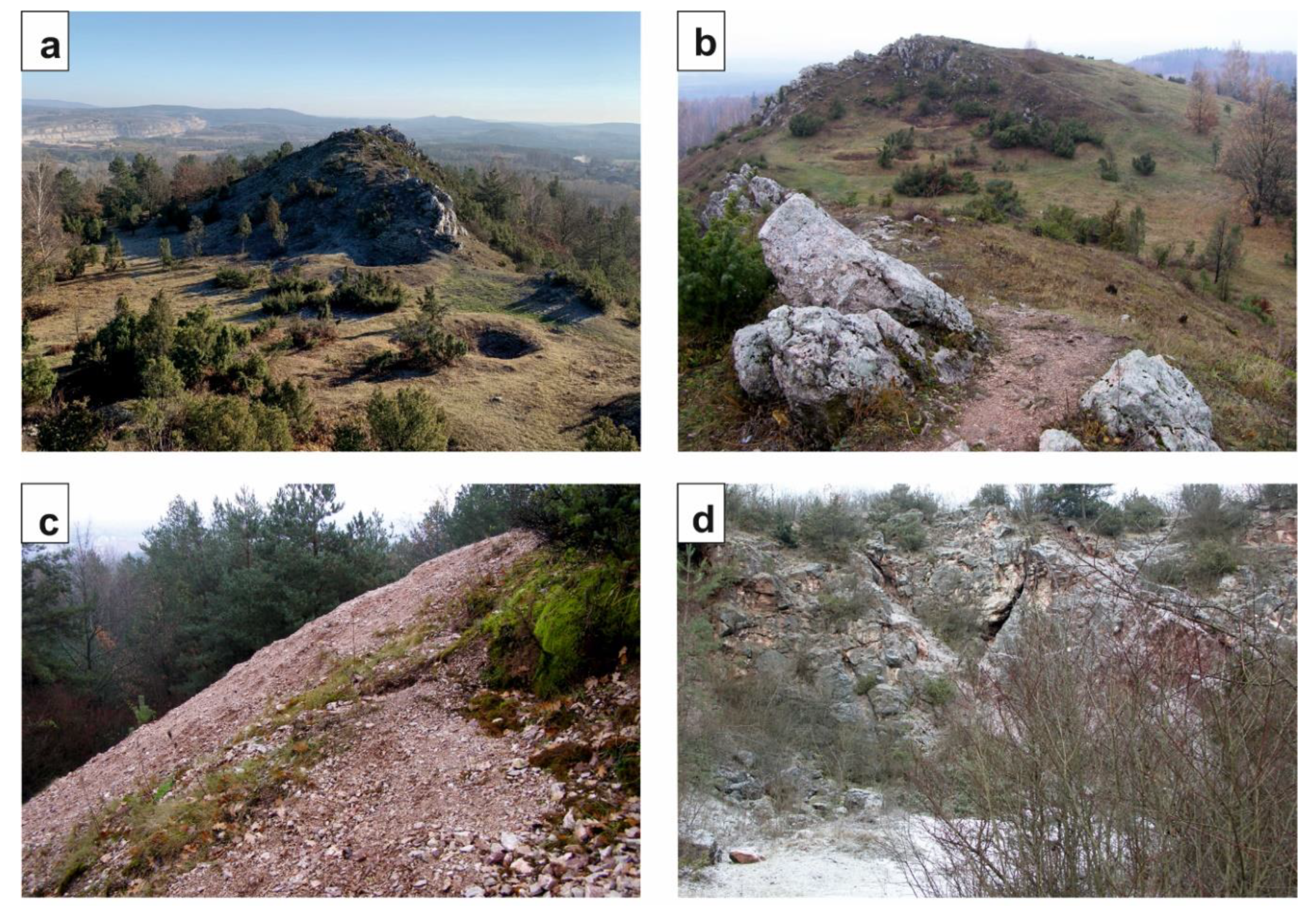
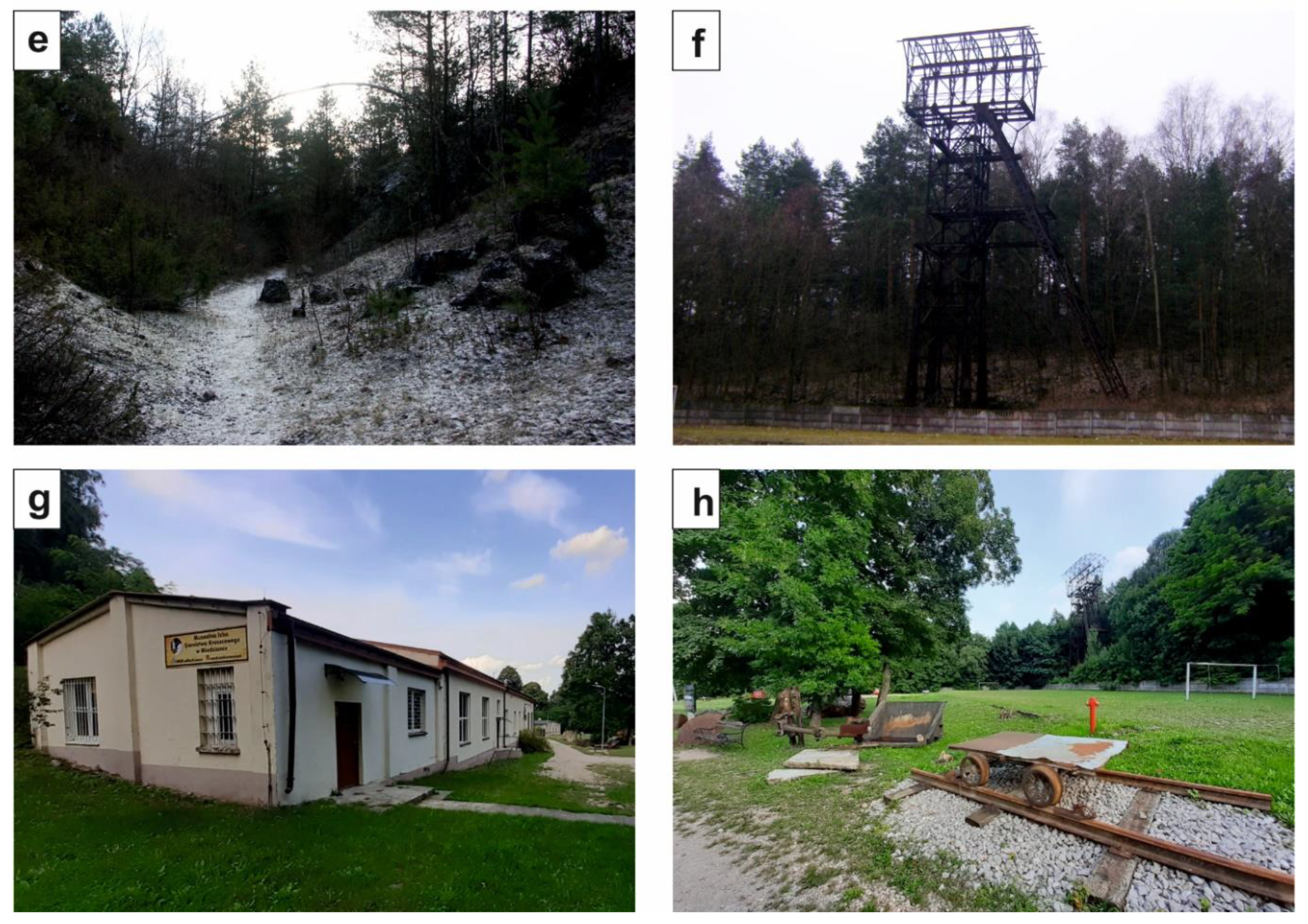
4.1. Unique Mining Sites in the Miedzianka Mountain

The Miedzianka Mountain is included in the Miedzianka Mountain Reserve, which is an inanimate nature reserve. The area of this reserve is approximately 0.25 km2. Within the boundaries of the reserve, numerous traces of old mining activity are observed.
There are several historical shafts and adits (e.g., Zofia, Teresa, Łaszczyńscy and Austrian) (Figure 2). There are also underground excavations and heaps, tunnels, etc. (Figure 3a–c). They are common on the southern and northern slopes in particular. There are also two abandoned quarries where the limestones were excavated (Figure 3d,e).
At the southeastern foot of the Miedzianka Mountain, there remains the steel structure of the shaft hoist tower of the old mine shaft “Piotr”, which was built in the 1950s (Figure 3f). It is the only one preserved in the Świętokrzyskie Mountains.
The Museum Chamber of Ore Mining in Miedzianka was created in the year 2008 in Miedzianka. The museum is devoted to history of mining in the Miedzianka Mountain; the museum exhibit contains numerous documents and historical photographs on the topic as well as a field exposition of ores and rocks in addition to mining instruments and machines (Figure 3g,h).

4.2. History of Mining Activity and Exploration in the Miedzianka Mountain

The history of copper mining in the Miedzianka Mountain area is associated with multiple periods of operation, discontinuation and resumption of activity [43]. The mining operations in the Miedzianka Mountain likely began in the Bronze Age (1800–700 B.C.) [14]. The first written accounts of the mining come from the 13th century [14]. Historical documents indicate that the peak of silver, copper and gold excavation occurred in the 15th century and the first half of 16th century [40]. This is documented in the records of King Kazimierz Jagiellończyk from 1478 [9]. Descriptions from Chęciny County in 1569 [43] show that during the reign of King Zygmunt Stary, Queen Bona and their son Zygmunt August, mines and smelters were established in which copper ores, azurite, silver and malachite were mined.
In the 17th century (during the reign of King Jan Sobieski), the Miedzianka Mountain field was made famous in Europe due to the fact that a local steward in the Chęciny region gave the pope a table made of azurite extracted from the Miedzianka Mountain deposit [29].
In the 18th century, the Ore Commission was established by King Stanisław August Poniatowski. It included foreign specialists, and the aim was to study the ore deposits in Polish lands, especially in the Miedzinka Mountain [29].
The 19th century was a time when intensive mining works were carried out in the Miedzinka Mountain. From 1800 to 1809 the Austrians conducted intensive mining works in the Miedzianka Mountain. They introduced modern exploitation methods (including the use of explosives). At that time the first detailed “illustration” of the mine in the Miedzianka Mountain was created by order of the government of the Duchy of Warsaw. The mining was carried out with ramps and exploratory in addition to extractive underground galleries and shafts. At that time, a few shafts and adits were established. The Austrian (also called Antoni) shaft (Figure 3) was established, where an accumulation of copper ores was discovered on the border of Triassic sandstone and clay (Buntsandstein) and Devonian limestones. The Teresa adit was also established in the Devonian limestones. Copper ore was found in a group of fine veins [43] (Figure 3). The Zofia (also called Maria) shaft was also built in Middle Devonian limestones (Figure 2). In 1816 the Old Polish Industrial District was established, thanks to the efforts of Stanisław Staszic (1755–1826), a famous geographer, geologist, researcher and politician [10]. The Academic Mining School was also founded in Kielce at that time. The mine in the Miedzianka Mountain produced 2835 tons of ore, containing 235 tons of coppers, between 1817 and 1827 [44]. Probably due to the difficult political situation in Poland, the mines were closed from the 1830s.
In the beginning of the 20th century, copper ore exploitation in the Miedzianka Mountain was restored. In 1902 the Łaszczyńscy family established the Łaszczyńscy adit in Middle Devonian limestones (Figure 2). The exploration was continued until 1907 when the catastrophic flooding of the mine happened, because the operation was carried out below the groundwater level [32].
The next period was during World War I (1916–1918), when the Austrians started the extraction of copper ore in the Miedzianka Mountain. The mining operation was carried out below the groundwater level, and this level was lowered by water pumps. They exploited one of the ore-bearing veins in Devonian limestones that was over 110 m long (wire 2–4 cm thick) at a depth of 40 m, and extracted 1264 tons of ore for war purposes [32,43]. Other sources say that in the period of 1915–1917 the Austrians mined 1054 tons of ore from the Miedzianka Mountain, yielding 66 tons of copper and 91 kg of silver; this would indicate the ore grade was 6.3% Cu and 0.0087% Ag ([11] and references therein).
After World War I attempts to resume work again were made by the Łaszczyńscy family. However, in 1922 the underground work was finally interrupted, and the mine was flooded. From that time the limestone was exploited in newly established quarries. In the years 1950–1954 mining exploration works were carried out.
Ultimately, mining in the Miedzianka Mountain was finished in 1954 because of severe mining conditions, noncommercial resources of ores and the discovery of a new copper deposit on the Fore-Sudetic Monocline [12]. After the mining activities were finished, the Miedzianka Mountain Reserve was established in 1958 in order to protect the remains of copper and silver mining activity in this area.

4.3. The Exploitation Methods in the Miedzianka Mountain Deposit

Mining works in the Miedzianka Mountain area were usually carried out with a shaft system, in which horizontally arranged galleries departed from the main shaft at various levels. Another method of exploitation was the rift system, which consisted of conducting mining works along karst crevices. The exploited spaces were characterized by variable width and height dimensions. There was also a chamber system, where the nest concentrations of copper ore in karst chambers were exploited [12].
Before the 15th century the operations were mostly surface mining, leaving behind numerous funnel-shaped structures, holes which are sinkholes of former shafts and heaps of waste rock surrounding the funnels [9].
In the 15th and 16th centuries, during the heyday of mining in the Miedzianka Mountain, the richest shallow underground deposits were exploited [40]. Miners got underground along tectonic fissures and through karst channels. Therefore, exploited spaces from that time often have very irregular shapes and directions. The corridors are sometimes so low that the miner had to work on his knees and sometimes move around on all fours. The miners used tallow lamps (vessels with animal fat) to illuminate underground workings. Ore deposits were mined mainly with the use of two tools: a wedge-shaped iron and a hammer. The excavated material was transported in wooden transport troughs.
From the beginning of the 19th century, modern exploitation methods were introduced in the Miedzianka Mountain. Drilling machines and explosives began to be used in the mine. Therefore, the galleries dug in massive Devonian limestone have more regular shapes and directions. In the 20th century, mining carts were also introduced for underground transport. This resulted in the transformation of corridors—they became regular and quite wide. The remains of blast holes are preserved on the walls of exploited spaces [40].

5. Teresa Adit

On the eastern slope of the Miedzianka Mountain there is an abandoned quarry. The entrance to the Teresa adit is located on the eastern part of this quarry (Figure 2). The entrance is a hole in the bottom of the quarry: this is the mouth of the adit and is secured with a fence [12]. The Teresa adit is located within the Upper Devonian–Frasnian and Famennian limestones, cut by cherry, marly shales (Famennian) in several places. The Teresa adit has a length of 523 m, of which 270 m is karst corridors of a natural cave visibly changed by mining works (artificial corridors and trenches). The denivelation of the cave part is 16 m, and the denivelation of the entire underground system is 21 m (Figure 4). The corridors run in the NW-SE direction [26]. Two shafts in the Teresa adit are described: shaft one is 8.73 m deep, and shaft two is 9.67 m deep. Both have a wooden casing at the level of the shaft opening.
The Teresa adit was opened as a mine at the beginning of the 19th century (years 1800–1809) and operated until the 1940s. Nowadays, the Teresa adit is unavailable to the general public; access requires the permission of the Regional Director for Environmental Protection in Kielce. Due to the specific nature of the Teresa adit and the varying degree of preservation of its underground workings, its exploration now requires great speleological skills and experience. The entrance to the adit is not extended. Exploration of it requires the participation of an experienced speleologist and specialist equipment.

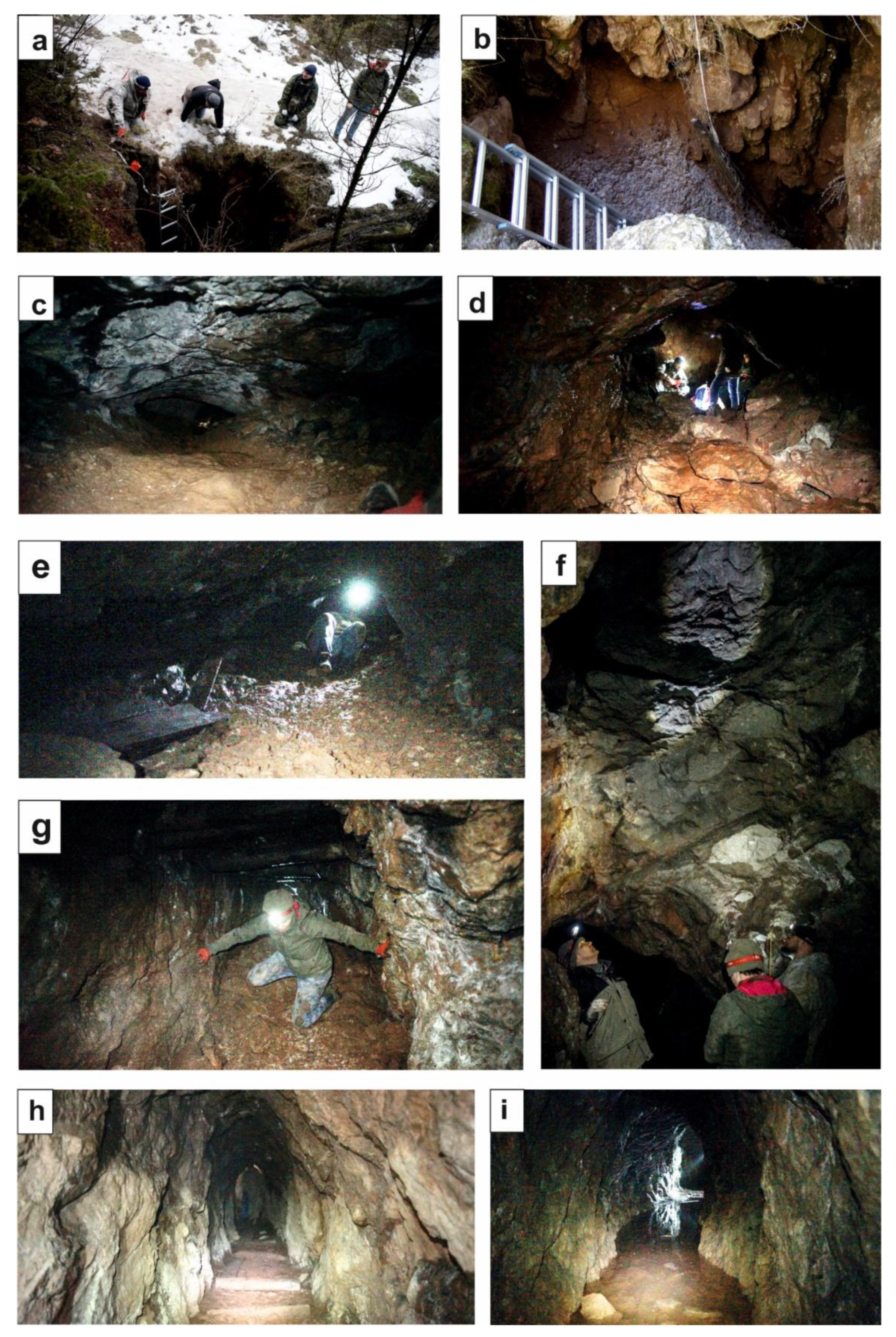
6. Research Methods of the Teresa Adit

Study of the Teresa adit took place in 2019, after obtaining permission from the Regional Director for Environmental Protection in Kielce. The study was attended by geologists and speleologists. All available caves, corridors and underground galleries of the Teresa adit were penetrated. The authors of the article did not examine the two shafts, which are present in the studied adit, because their penetration requires the use of specialized climbing equipment.
Seven representative sites with symbols P1–P7 were selected for detailed study (Figure 4). The distance between the sites furthest apart was 150 m (Figure 4). The sites and area between them were photographed in detail. From each site representative samples were collected. In total, twenty-three rock samples were obtained. The samples were chipped (detached) with a hammer and also drilled using a core drill with an internal diameter of 2.5 cm. Each sample was cut and their surface was polished for the aim of the detailed study of, among other things, the mineralization.
The representative samples were photographed, under the same lighting conditions, to present a record of geological processes in the rocks. Photos were obtained using a CANON EOS 90D digital SLR camera.
The minerals directly in the adit and in the collected samples were identified based on the macroscopic physical properties (for example: color, hardness, cleavage and streak) and chemical properties (reaction of calcite with hydrochloric acid) of minerals. The collected samples were also analytically studied in detail (optical microscopic and microprobe chemical analyses (EDS) and X-Ray Diffraction (XRD). The obtained analytical results will be the subject of another article (in preparation).
The samples are archived at the Institute of Geography, Geology Department, Pedagogical University of Krakow, Podchorążych 2, 30-084 Kraków, Poland; Collection reference: Góra Miedzianka, 2019/ P1–P7.

7. Results of Geological Study of the Teresa Adit

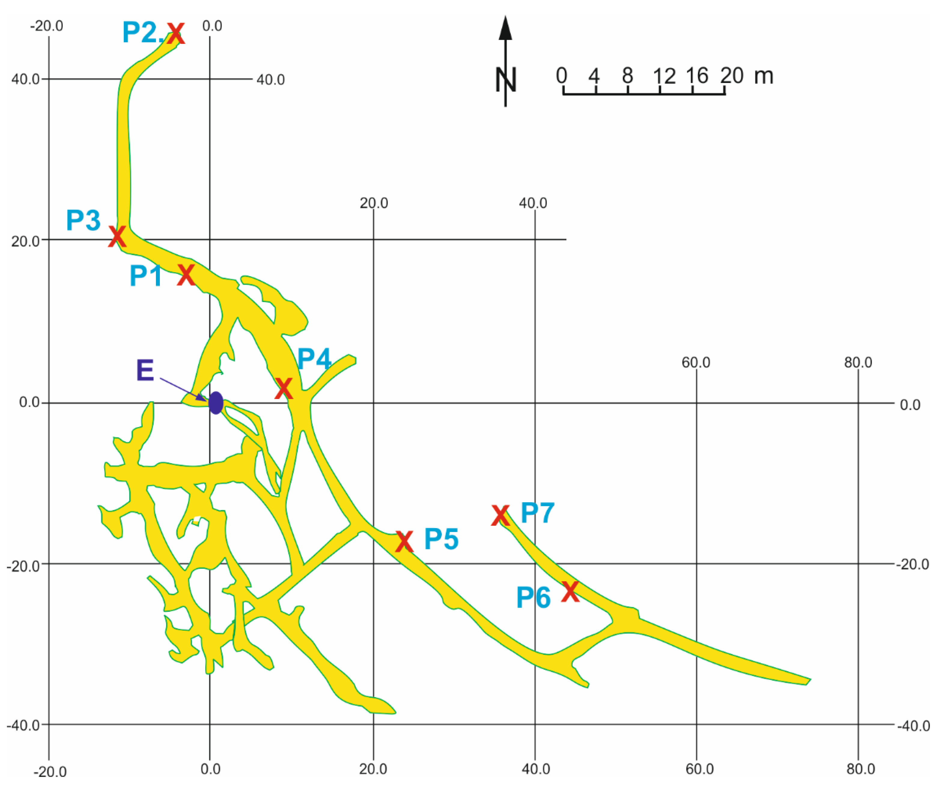
7.1. Characteristic of the Studied Sites in the Teresa Adit

Seven selected sites (P1 to P7) (Figure 4) are representative and display interesting geologies, structures, mineralization and minerals. They represent natural cave corridors, cave corridors changed by mining operations, and underground galleries created during the mining works.
The entrance to the adit (it was partially buried, and recently it was cleared of rubble and widened) is an almost vertical trench (its depth is approximately 5 m), which narrows downwards to form a chimney (Figure 5a,b).
There is a passage from the chimney to a larger natural chamber of the cave (site P1, Figure 5c), from which there is a passage to an adit gallery. This gallery in the northern direction is a dead end (site P2, Figure 4). Towards the south, galleries diverge in different directions. In the southwest direction, there are the cave corridors partially modified by mining works, while in the southeast direction there are artificially constructed galleries (Figure 4).
In the natural part of the cave there are small chambers with heaps of waste rocks (Figure 5d, site P3) and a large chamber about 4 m high and from 2 to 5 m wide (site P4, Figure 5f). This chamber is located near the entrance and further corridors diverge from it to other parts of the adit (Figure 4).
Going southeast, there are galleries already excavated by mining works (site P5, Figure 5g,h). These galleries are hollowed in Upper Devonian limestones and are 1.4 to 2.2 m high and 0.8 to 1.8 m wide. Their walls are quite regular and the ceilings are semicircular (Figure 5h). The branch to the east is flooded with water (Figure 5i).
The entire Teresa adit is quite humid. In winter, frost is visible on the rocks of walls of galleries and corridor walls (especially in the part of the entrance to the adit where cold air from the outside enters).

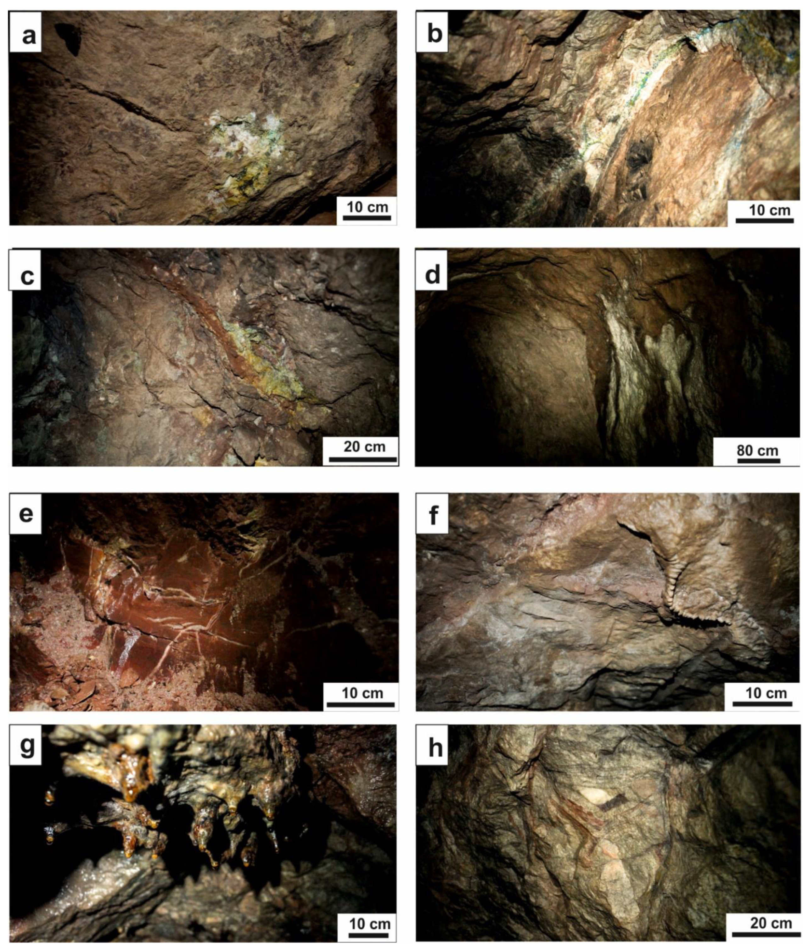
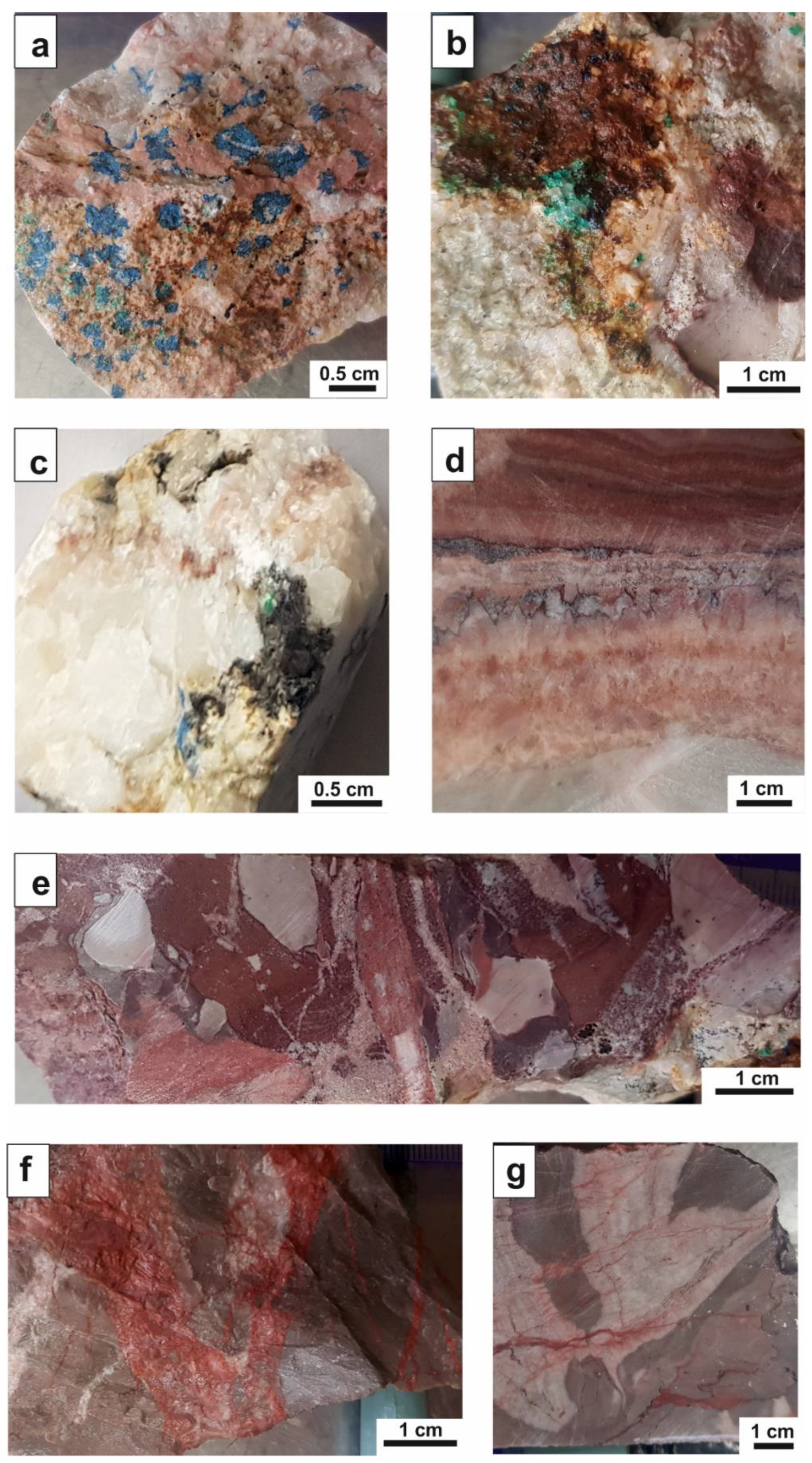
7.2. Mineralogical Features and Speleothems in the Teresa Adit

The limestones and cherry, marly shales of the Upper Devonian were observed during the exploration of the Teresa adit. The limestones are strongly tectonically deformed and cut with numerous veins of different mineral compositions and various colors: white, red, green–blue and black.
Ore mineralization with secondary copper carbonates, such as malachite and azurite, occurred. They are well visible on the side walls and the ceiling of underground galleries (sites P6 and P7, Figure 6a–c). In studied sites these minerals often occur together. The malachite and azurite ore form nests (Figure 6a), the sizes of which can reach up to 20 cm. They also occur as mineralization in calcitic veins (Figure 6b,c). The sizes of the observed veins range from 5 to 15 cm in width. The detailed style of the mineralization is clearly visible in the collected samples. In Figure 7a the diffuse mineralization of blue azurite in pink calcite is presented. In Figure 7b a malachite nest is presented together with brown iron oxides and hydroxides, which are secondary minerals after primary sulfides. Moreover, detailed studies of the collected samples showed the presence of a very fine mixture of black colors, consisting of earthly cuprite, silica, Fe oxides and Mn oxides, so-called black copper ore [45], within white calcite veins (Figure 7c).
In some studied sites, for example, in sites P1, P4 and P5, the white and pink sparite calcite veins are present. Calcite crystals can form veins and nests. The size of observed veins ranged from 2–15 cm (Figure 6b), and nest widths were up to approximately 20 cm. Calcite can be accompanied by various minerals. Most often they are green malachite and blue azurite, and sometimes they are a black mineral formed of a mixture of powdered cuprite with oxides or hydroxides of iron and silica, the so-called black copper ore [45]. Detailed studies of calcite veins in polished rocks (Figure 7d) shows a sequence of thin, calcite laminae (about 0.5 cm thick) of different colors, as pink, white and brown. This laminae alternation suggests several generations of mineralization.
In natural parts—caves—of the studied adit there are characteristic karst structures, such as coatings, flowstone, dripstones and stalactites. In some sites, for example P2 and the area close to P3, there are large hematite flowstone on walls and ceilings of the underground gallery (Figure 6d,e). Their color varies in shades of red, orange–yellow, red, brown and dark-brown, related to the admixture of secondary Cu minerals in Fe oxide minerals.
Other characteristic structures of speleothems on the limestones are stalactites observed in natural parts (caves) in the studied adit, especially in sites P4 and P1. They are stalactites made of white calcite (Figure 6f) and a brown to dark-brown color of hydroxide minerals (Figure 6g). The length of the stalactites reaches up to about 35 cm. They belong to the most interesting natural karst forms in the studied tunnel. Such brown-colored stalactites are most commonly found in the zones of karstification of ore deposits. Among the interesting structures observed in some sites (e.g., site P1 and the area close to site P4) is tectonic breccia developed within limestones (Figure 6h). The width of this tectonic zone is about 50 cm. Detailed study of polished rock sections shows that breccia is composed of gray-colored clasts of limestones, cemented by white and pink calcite and cut by Fe oxide veins (Figure 7e–g). The thicknesses of these veins vary from 1 mm to 5 cm (Figure 7f,g). This breccia zone is related to the rejuvenation of Variscan faults [21].

8. Educational, Scientific, Mining and Historical Heritage of the Miedzianka Mountain Deposit

The Miedzianka Mountain ore deposit is described in the historical chronicles as a very rich deposit of copper and silver. It had a great influence (until the 1920s) on economic development, and thus it was strongly marked in the history of Poland. The history of copper mining in the Miedzianka Mountain probably began as early as the Bronze Age (1800–700 B.C.) [14]. The first written documents on the exploitation of ore deposits date back to the 13th century. The 15th century and the first half of the 16th century were the period of the greatest mining of copper, silver and gold [40]. This period is regarded as the golden age of Polish history, because it was associated with economic and political achievements. At that time, King Zygmunt Stary of the Jagiellonian Dynasty founded a Chapel of Zygmunt in the Wawel Cathedral—a mausoleum of the Jagiellonian Dynasty. This chapel is built in the Renaissance style; the main architect of this building was the famous Italian architect Bartolomeo Berecci. An important aspect related to the Miedzianka deposit is the fact that the dome of this chapel was covered with gold extracted from this deposit [46] (Figure 8). Since historical times, this chapel was called the “Pearl of the Renaissance north of the Alps” due to the unique features of the Renaissance style. This name has survived to the present day.
In the 17th century, in the Miedzianka Mountain deposit, a rich mineralization with azurite was found, which made it possible to make a table with azurite inlays, which was given to the pope—Innocent XI [43]. It was an event that led to the promotion of Miedzianka Mountain ore deposits as well as Poland in Europe.
The Miedzianka Mountain ore deposit also had an important influence on the development of modern geology and mining in Poland. At the end of the 18th century, during the reign of King August Poniatowski, the Ore Commission was established, in which domestic and foreign researchers worked. The aim of the Commission was to search for and research ore deposits using modern exploration methods. One of the first important researchers was Stanisław Staszic (1755–1826), who conducted intensive research on the Miedzianka deposit in the years 1809 to 1816. Due to his enormous influence on the introduction of modern mining and metallurgical methods, he is called the “Father of Polish geology”. At that time, the Antoni shaft and the Teresa and Zofia adits in the Miedzianka Mountain were established. Their method of drilling (using explosives and specialized tools) is an example of introducing modern technologies to mining works. The intensive development of mining in the area of the Miedzianka Mountain influenced the development of mining and geological education. At that time, in 1816, due to the demand for educated people, the Academic Mining School in Kielce was established [21].
The name of the mineralogist and petrographer J. Morozewicz (1865–1941), known in Europe, is clearly associated with the Miedzianka Mountain ore deposit, who described three new minerals during his research on the Miedzianka Mountain deposit: (a) staszicite (in memory of S. Staszic) [17], (b) lubeckite (in remembrance of the Minister of the Treasury of the Kingdom of Poland, Prince F. K. Drucki-Lubecki (1778–1946) [18] and (c) miedziankite (after the mountain itself) [45]. At that time (early 20th century), this researcher did not present detailed studies on these mineral phases because he did not have the required technological equipment—it was only possible to complete that research at the end of the 20th century. Therefore, the names of these minerals were not approved by the IMA Commission on New Minerals, Nomenclature and Classification. The compositions of the minerals are as follows: staszicite is a synonym for conichalcite, lubeckite probably refers to cuprian-cobaltoan vad and miedziankite is probably a zincian variety of tennantite [11].
Despite the fact that the Miedzianka Mountain ore deposit is no longer exploited (since the 1950s), mineralogical, geochemical and geological studies are still being carried out on the Miedzianka Mountain, e.g., [11,14,21,24,25,27,38,39,40,41,42]. As a result of this research, 40 minerals from this deposit have been described so far [11]. They are mainly copper ore minerals, but also very rare minerals, including arsenates and vanadates. Mineralogical and geochemical research in recent years has focused on materials obtained from old heaps, e.g., [11,25]. These scientific studies show the processes of the formation of new mineral phases in the conditions of weathering and exposure to environmental pollutants. The nature of the Miedzianka Mountain deposit, and the constant interest of researchers on different generations in this deposit prove that it is an object of high scientific potential. The field trip programs of various conferences, as well as scientific meeting and sessions that are organized in the area of the Świętokrzyskie Mountains usually include the Miedzianka Mountain ore deposit. An example would be the conferences of the Polish Geological Society, e.g., meetings in 1921, 1962, 1993, 2006 [47,48,49]. Polish geologists, mineralogists, geographers, geomorphologists, miners and many researchers from Poland and other countries participate in these conferences. Recently, in 2019, the 26th meeting of the petrology group of the Polish Society of Mineralogy in Chęciny was held, and the “iron point” of which was a trip to the copper field of the Miedzianka Mountain ore deposit.
The Miedzianka Mountain ore deposit has been offering the excellent educational opportunity to study geology, mineralogy and ore mining for 200 years, since 1816, when the Academic Mining School in Kielce was established. Subsequent generations of geology and mining majors take part in field exercises or field trips, including students from the Jagiellonian University in Krakow, the University of Warsaw, the AGH University of Science and Technology, the Jan Kochanowski University of Kielce and the Pedagogical University of Krakow.
The important place of the Miedzianka Mountain deposit in the history of geology and mining in Poland is evidenced by the collections of minerals from this deposit being presented in many museums and private collections, and used for the education of geology and mining during studies, various practical courses and workshops for geology enthusiasts. Collections of these minerals can be admired in, for example: the Museum Chamber of Ore Mining in Miedzianka that was established in Miedzianka village, the Geological Museum in the Polish Geological Institute (PGI) in Kielce, the Nature Education Center of Jagiellonian University, the Geological Museum in the University of Science and Technology (AGH) and the Geological Museum in the Polish Academy of Science. The mineral collections from the Miedzianka Mountain are used in the education of geography students (e.g., Department of Geology of the Pedagogical University of Krakow).
The Miedzinka Mountain is a unique place of geological, mining, mineralogical and historical heritage. In addition, it has the scientific and educational values described above. Therefore, in 1958, the Miedzianka Mountain Reserve was established on and around the Miedzianka Mountain, in which efforts were made to preserve the traces of mining activities. In this reserve, you can see the remains of collapsed shafts (Figure 3a,b), the Piotr shaft tower (Figure 3f) and the chamber that was used to store the explosives when the mine was in operation. It should be mentioned that this is not the first preservation effort in the area; at the beginning of the 19th century, Jerzy Pusch-Koreński (1790–1846) appreciated the unique qualities of this region and already postulated the need to protect them [50]. In the 1950s, the natural landscape with the underground adit and shaft was used for the scenography of a movie, entitled “The Mystery of the Wild Shaft”.
The Miedzianka Mountain was included in the “Świętokrzyskie Archaeological and Geological Trail” (opened in 2011). The trail runs from Bałtów through Krzemionki Opatowskie, Nowa Słupia to the Miedzianka Mountain. The entire trail includes 27 objects and locations. Miedzianka Mountain is one of the six located in the Chęciny commune. It is one of the most interesting sites in the trail. On the trail there are information boards and geotouristic as well as educational paths, and many popularization materials about the trail have been published. All these bring this subject closer to tourists, geotourists, speleologists and enthusiasts of geology as well as the history of mining.
Seeing the need to popularize the history of mining activities, including the history of the Miedzianka Mountain ore deposit, an exhibition was made available at the Museum Chamber of Ore Mining in Miedzianka in 2008. Moreover, in 2015, in a closed quarry on the Rzepka Mountain (9 km southeast of the Miedzianka Mountain), the European Geological Education Center of the University of Warsaw was opened. Educational and research activities in the field of geological sciences as well as various scientific conferences, symposiums and conventions are carried out here.
Recently, there have been proposals to popularize this unique deposit even more. A project entitled the “Establishment of the Old Polish District of Ore Mining in Miedzianka” was created. This project was implemented in cooperation with the University of Science and Technology (AGH) in Kraków, the Institute of Nature Conservation of the Polish Academy of Sciences, the community of Miedzianka village and the Government of the Świętokrzyskie Voivodeship in 2014–2020 [12]. The project includes providing access to the underground galleries of the Teresa and Zofia adits after adaptation works to increase their safety and ease of access and the creation of an exhibition in the underground corridors of the adits, which will familiarize visitors with the subject of mining and geological works. The technical documentation includes underground works, for example the installation of electricity, the installation of sound, strengthening of side walls and the roof, etc. [15]. In addition, it is proposed to create a multimedia exhibition on environmental education and the history of mining and geology of this area with collections of minerals from the Museum Chamber of Ore Mining in Miedzianka. Additionally, there is an educational surface trail in preparation, which would include the available adits.

9. Geotouristic Potential of the Teresa Adit

Our geological research in the Teresa adit has shown that it has high scientific and geotouristic value. It displays a wide spectrum of scientific issues. There are seven sites with unique geological, mineralogical and mining topics as well as educational features, which are listed in Table 1. One of the main topics is the mineralization of copper ore. This study shows that the most interesting sites, in mineralogical terms (mineralization processes), are sites P7 and P6, where there are zones containing blue azurite and green malachite. The forms of karst occurrence in the natural parts of the adit are also very interesting; we can observe speleothems especially in sites P1, P3 and P4 (Figure 6d–g). Notable forms include karst characterized by a phenome of iron minerals as infiltrate speleothems (e.g., site P4, Figure 6g) and a large iron flowstone (site P1–P3). Site P4 deserves more attention. It is located inside of a large chamber about 4 m high and 2–5 m wide. This chamber is developed within the tectonic breccia zone with well-visible breccia on the walls (site P4, Figure 6h). Unfortunately, some of the cave’s corridors and chambers are transformed or partially destroyed by mining works. There are also heaps of waste rocks observed in the chambers (Figure 5c–e).
Traces of mining activity, visible in the underground galleries, are also interesting. Sites P2 and P5 through P7 present the remnants of mining operations. These are located in post-excavation galleries and the dead ends of galleries. Galleries are approximately 1.4 to 2.2 m high and 0.8 to 1.8 m wide. In these sites, mineralization in the individual veins of up to 16 cm wide and the remnants of blast holes can be observed.
It should be emphasized here that in the adit there are records of some deposit mineralization processes that are not observed on the surface in heaps and quarries. For example, the ore mineralization zones associated with the tectonic involvement of the rock mass (site P4, Figure 6b) are well visible in the studied adit. On the other hand, in the cave part of the studied adit, there are unique karst forms (e.g., sites P3 and P4, Figure 6e,g) that do not occur on the surface (quarry).

10. Summary

The Miedzianka Mountain ore deposit has a long history of mining of copper, silver and even gold. As discussed above with the most important facts, this deposit is undoubtedly an important site of geological and historical heritage. Since the 19th century, the scientific community in Poland (J. Pusch-Koreński) was aware of the unique value of this deposit and saw the need to preserve and protect it for future generations. Therefore, in 1958 the “Miedzianka Mountain Reserve” inanimate nature reserve was established. In 2008, the Museum Chamber of Ore Mining was established in Miedzianka village. Additionally, in 2011, the Archaeological and Geological Trail of the Świętokrzyskie Voivodeship was opened, and one of the important points on this trail is the Miedzianka Mountain. Recently, there was an initiative the technical, mining project entitled “Establishment of the Old Polish District of Ore Mining in Miedzianka” implemented in 2014–2020. This project is focused on making the Teresa and Zofia adits in the Miedzianka Mountain available to visitors from technical and safety aspects. This project runs in cooperation with the AGH University of Science and Technology in Kraków, the Institute of Nature Conservation of the Polish Academy of Sciences, the community of Miedzianka village and the Świętokrzyskie Voivodeship Government.
Our research widens the knowledge of ore mineralization and geotouristic values in relation to the Teresa adit, which has so far been poorly studied. Our analyses show that this adit displays a whole spectrum of topics in the field of mineralogy, geology, mining and history. Taking into account the projects for making the adits accessible to visitors, we suggest, based on our research, that the Teresa adit should be adapted first. We believe that in the Teresa adit there is a whole spectrum of topics in the field of mineralogy, geology, mining and history that could be presented to visitors. These include: (1) old mining works—galleries carved in the rock back in the 19th century, (2) interesting vein mineralization (secondary-colored copper carbonates and multi-colored calcite veins), (3) karst phenomena (coatings, flowstone, dripstones and stalactites) in a cave formed in the limestones of the Upper Devonian (Frasnian–Famennian), which is a natural part of the Teresa adit and which has been partially transformed by mining works. The proposed seven sites on the underground route could be the basis for further works to create a “geotouristic trail” in the Teresa adit.
The proposal to make the Teresa adit available to tourists is in line with tendencies to protect the post-industrial landscape associated with former mining activities, as described in the work of Gioncada et al. [51]. Numerous articles postulate the creation of geotouristic/touristic routes in such areas, where subsequent geosites are old and abandoned mines or tunnels [52]. In areas of old unique deposits (e.g., Lavrion, Greece), it is suggested to create a future UNESCO Global Geopark [53]. The creation of underground mining routes in old mines has a positive impact on the protection of cultural and industrial heritage, activates the region economically, but it also has negative aspects—increasing costs of maintenance or adaptation to touristic needs/functions [54].
Access to the adits located on the Miedzianka Mountain for tourists requires large financial outlays. Therefore, the authors suggest the creation of an underground mining route in only one adit, for example, in the Teresa adit, which will reduce investment costs and at the same time protect the unique mining heritage.

Author Contributions

Conceptualization, A.C., A.W., and M.S.; Methodology, A.C., A.W., M.S., and W.C.; Investigation and Data Curation, A.C., A.W., and M.S.; Writing—Original Draft Preparation, A.C. and A.W.; Writing—Review and Editing, A.C., A.W., M.S., and W.C. All authors have read and agreed to the published version of the manuscript.

Funding

The research was financed from statutory research of the Pedagogical University: Project BN.610-408/PBU/2020.

Data Availability Statement

The samples are archived at the Institute of Geography, Geology Department, Pedagogical University of Krakow, Podchorążych 2, 30-084 Kraków, Poland; Collection reference: Góra Miedzianka, 2019/ P1-P7.

Acknowledgments

The authors thank the Regional Director for Environmental Protection in Kielce, Ing. Aldona Sobolak, for issuing permission for study of the Teresa adit. The authors are also grateful to two anonymous reviewers for constructive suggestions and thorough, critical comments on the manuscript.

Conflicts of Interest

The authors declare no conflict of interest.

References

  1. Hallam, A. Great Geological Controversies, 2nd ed.; Oxford University Press: Oxford, UK, 1989. [Google Scholar]
  2. Anonymous. In Proceedings of the First International Symposium on the Conservation of our Geological Heritage, Digne, France, 11–16 June 1991; Terra Abstracts Supplement 2 to Terra Nova Volume 3. p. 17.
  3. Joyce, E.B. Geological Heritage Committee. In Rock Me Hard. Rock Me Soft; A History of the Geological Society of Australia Inc.; Cooper, B.J., Branagan, D.F., Eds.; Geological Society of Australia Inc.: Sydney, Australia, 1994; pp. 30–36. [Google Scholar]
  4. O’Halloran, D.; Green, C.; Harley, M.; Stanley, M.; Knil, J. (Eds.) Geological and Landscape Conservation. In Proceedings of the Malvern International Conference 1993; Geological Society: London, UK, 1994. [Google Scholar]
  5. Busby, A.B., III; Conrads, R.; Willis, P.; Roots, D. An Australian Geographic Guide to Fossils & Rocks; Australian Geographic: Sydney,Australia, 2001; pp. 1–288. [Google Scholar]
  6. Sharples, C. Geoconservation in forest management—Principles and procedures. Tasforests 1995, 7, 37–50. [Google Scholar]
  7. Sharples, C. Concepts and Principles of Geoconservation; Tasmanian Parks & Wildlife Service: Hobart, Australia, 2002; pp. 1–79.
  8. Sadry, B.N. (Ed.) The Geotourism Industry in the 21st Century: The Origin, Principles, and Futuristic Approach; Apple Academic Press, Inc.: Palm Bay, FL, USA, 2021; pp. 1–596. [Google Scholar]
  9. Pyzik, Z.W. Materiały archeologiczne do znajomości górnictwa i hutnictwa kruszcowego na obszarze województwa kieleckiego. Sesja z okazji jubileuszu IX wieków Kielc, 11. Listopada 1970 r. In Dzieje i Technika Świętokrzyskiego Górnictwa i Hutnictwa Kruszcowego; Wyd. Geologiczne: Warszawa, Poland, 1972; pp. 101–105. [Google Scholar]
  10. Braun, J. Miedzianka—Karta z dziejów kopalnictwa i przetwórstwa miedzi w rejonie chęcińskim. Rocz. PTTK Ziemia 1968, 1, 41–47. [Google Scholar]
  11. Kozłowski, A. Native gold from Miedzianka Mt., Świętokrzyskie Mts. In Gold in Poland; Kozłowski, A., Mikulski, S.Z., Eds.; Uniwersytet Warszawski, Wydział Geologii, Państwowy Instytut Geologiczny, Państwowy Instytut Badawczy, AM Monograph: Warszawa, Poland, 2011; Volume 2, pp. 339–349. [Google Scholar]
  12. Borowiecki, N.; Barzycki, M.; Chudzik, W. Możliwości zagospodarowania naturalnych i pogórniczych podziemi rezerwatu “Góra Miedzianka” do celów geoturystycznych. Bezpieczeństwo Pr. Ochr. Sr. Górnictwie 2017, 275, 8–17. [Google Scholar]
  13. Wolska, A.; Ciurej, A.; Kowalik, S. The use of natural resource in the interior design of the main building of the Pedagogical University of Cracow. Biul. Państwowego Inst. Geol. 2018, 472, 339–348. [Google Scholar] [CrossRef]
  14. Kowalczewski, Z. Historia Górnictwa Świętokrzyskiego—Geologia Złóż, Dzieje Eksploatacji, Wykorzystanie Kopalin. In Proceedings of the 42 Zjazd Polskiego Towarzystwa Geologicznego, Kielce, Poland, 27–30 June 1993; pp. 7–8 & 24–32. [Google Scholar]
  15. Studium wykonywalności inwestycji w ramach Regionalnego Programu Operacyjnego Województwa Świętokrzyskiego na lata 2014–2020. “Utworzenie Staropolskiego Ośrodka Górnictwa Kruszcowego w Miedziance”. Gmina Chęciny. Świętokrzyski Informator Samorządowy 15. Nasz Reg. 2015, 7–8, 15. [Google Scholar]
  16. Staszic, S.; O Ziemiorództwie Karpatów i Innych Gór i Równin Polski. Warszawa, w Drukarni Rządowei 1815, 107s. + Atlas. Available online: https://jbc.bj.uj.edu.pl/dlibra/doccontent?id=267 (accessed on 15 June 2021).
  17. Morozewicz, J. O kobaltowym minerale Miedzianki, lubeckicie. Rozprawy Akademii Umiejętności-Rozprawy Wydziału Matematyczno-Przyrodniczego. ser. III, t. 18 (58), dział A, Drukarnia UJ—1919, 205–209 (Wielkopolska Biblioteka Cyfrowa: Cz3216-1919).
  18. Morozewicz, J. Staszycyt—Nowy Minerał Złoża Kruszcowego na Miedziance (Staszicit, ein neues Mineral des Kupfererzvorkommens Miedzianka). Rozprawy Akademii Umiejętności-Rozprawy Wydziału Matematyczno-Przyrodniczego. ser. III, t. 18 (58), Dział A, Drukarnia UJ—1919, 123–134 (Wielkopolska Biblioteka Cyfrowa: Cz3216-1919).
  19. Czarnocki, J. Marmury świętokrzyskie. W: Materiały do znajomości skał w Polsce. Biul. Inst. Geol. 1952, 80, 27–48. [Google Scholar]
  20. Rubinowski, Z. Wyniki badań geologicznych w okolicy Miedzianki świętokrzyskiej. Biul. Inst. Geol. 1958, 126, 143–153. [Google Scholar]
  21. Rubinowski, Z. Z badań złóż kruszców w Polsce. Biul. Inst. Geol. 1971, 247, 27–46 & 105–132. [Google Scholar]
  22. Rubinowski, Z. Interpretacja górniczo-geologiczna planu kopalni w Miedzianej Górze z 1782 roku. Studia Kieleckie 1984, 1, 65–80. [Google Scholar]
  23. Wieser, T.; Żabiński, W. Copper arsenate and sulphate minerals from Miedzianka near Kielce (Poland). Mineral. Pol. 1986, 17, 17–42. [Google Scholar]
  24. Balcerzak, E.; Nejbert, K.; Olszyński, W. Nowe dane o paragenezach kruszcowych w żyłach siarczków pierwotnych złoża Miedzianka (Góry Świętokrzyskie). Przegląd Geol. 1992, 40, 659–663. [Google Scholar]
  25. Swęd, M.; Urbanek, P.; Krechowicz, I.; Dworczak, P.; Wiecka, P.; Mleczak, M.; Tobys, P. Mineralogia hałd wietrzeniowych złoża Miedzianka (Góry Świętokrzyskie). Przegląd Geol. 2015, 63, 363–372. [Google Scholar]
  26. Recielski, K. Jaskinia w Sztolni Teresa na Miedziance. In Jaskinie Regionu Świętokrzyskiego; Urban, J., Ed.; PTPNoZ: Warszawa, Poland, 1996. [Google Scholar]
  27. Ciurej, A.; Struska, M.; Wolska, A.; Chudzik, W. Atrakcje geoturystyczne rejonu pogórniczego na przykładzie dawnej sztolni Teresa, Góra Miedzianka koło Chęcin. In Proceedings of the XXIX Konferencja Aktualia i Perspektywy Gospodarki Surowcami Mineralnymi, 6–8 November 2019; Rytro: Nowy Sącz, Poland, 2019; pp. 15–17. [Google Scholar]
  28. Brygier, W. Góry Świętokrzyskie Przewodnik z Mapami; Galileos, Wydawnictwo Studio Plan: Wrocław, Poland, 2011; 48p. [Google Scholar]
  29. Kotański, Z. Przewodnik Geologiczny po Górach Świętokrzyskich (Geological Guidebook to Świętokrzyskie Mountains); Wyd. Geologiczne: Warszawa, Poland, 1959; pp. 1–204. [Google Scholar]
  30. Mizerski, W. Geologia Polski; PWN: Warszawa, Poland, 2009; pp. 119–122. [Google Scholar]
  31. Czarnocki, J. Ogólna Mapa Geologiczna Polski, Arkusz 4 Kielce. (General Geological Map of Poland, Sheet 4 Kielce); Państwowy Instytut Geologiczny: Warszawa, Poland, 1938. [Google Scholar]
  32. Czarnocki, J. Surowce mineralne w Górach Świętokrzyskich. Surowce skalne. Pr. Państwowego Instytutu Geol. 1958, 21, 128–160. [Google Scholar]
  33. Kaźmierczak, J. Morphogenesis and systematics of the Devonian stromatoporoidea from the Holy Cross Mountains, Poland. Palaeont. Pol. 1971, 26, 5–147. [Google Scholar]
  34. Racki, G. Evolution of the bank of reef complex in the Devonian of the Holy Cross Mountains. Acta Palaeont. Pol. 1993, 37, 87–182. [Google Scholar]
  35. Narkiewicz, M.; Racki, G.; Skompski, S.; Szulczewski, M. Zapis procesów i zdarzeń w dewonie i karbonie Gór Świętokrzyskich. In Przewodnik LXLVII Zjazdu Nauk PTG, Ameliówka k. Kielc, Poland, 28–30 June 2006; Skompski, A., Żylińska, Eds.; Państwowy Instytut Geologiczny: Warszawa, Poland, 2006; pp. 51–77. [Google Scholar]
  36. Czarnocki, J. Mapa Geologiczna Środkowej Części Gór Świętokrzyskich w Skali 1:100000 Wraz z Objaśnieniami; Wyd. Państwowego Instytutu Geologicznego: Warszawa, Poland, 1919. [Google Scholar]
  37. Kowalski, W. Tektonika zachodniego zakończenia antykliny chęcińskiej i otaczających ją struktur obrzeżenia mezozoicznego. Rocz. Pol. Tow. Geol. 1975, 40, 45–62. [Google Scholar]
  38. Rubinowski, Z. Zarys metalogenezy paleozoiku świętokrzyskiego (An outline of the metallogeny of the Świętokrzyskie Mts. Paleozoic rocks). Przegląd Geol. 1962, 10, 395–399. [Google Scholar]
  39. Rubinowski, Z. The position of barite mineralization in the regional metallogeny of the Góry Świętokrzyskie. Origin, occurrence and exploration of barite. Pr. Inst. Geol. 1970, 59, 125–155. [Google Scholar]
  40. Wróblewski, T. Rys historyczny górnictwa kruszcowego w Górach Świętokrzyskich. Przegląd Geol. 1962, 10, 414–417. [Google Scholar]
  41. Jaśkowski, B.; Kowalski, B.; Sołtysik, R. Góra Miedzianka—Budowa Geologiczna i Historia Eksploatacji Rud Miedzi. In Proceedings of the Konferencja Naukowa nt. Geomorfologia gór i Wyżyn w Polsce—Kontrowersje i Nowe Spojrzenia, Kielce, Poland, 16–19 May 2000; pp. 90–94. [Google Scholar]
  42. Wojciechowski, A. Hałdy dawnego górnictwa świętokrzyskiego jako źródło metali kolorowych i szlachetnych. Przegląd Geol. 2002, 50, 240–244. [Google Scholar]
  43. Kotański, Z. Z plecakiem i młotkiem w Góry Świętokrzyskie. In Przewodnik Geologiczny dla Turystów; Wyd. Geologiczne: Warszawa, Poland, 1968; p. 225. [Google Scholar]
  44. Łabęcki, H. Górnictwo w Polsce: Opis kopalnictwa i Hutnictwa Polskiego Pod Względem Technicznym, Historyczno-Statystycznym i Prawnym; Drukarnia Jana Kaczanowskiego: Warszawa, Poland, 1841; Volume 1, pp. 1–538, Public domain: Biblioteka UŚ Katowice, źródło BG-256389/I-II. As of: 30.05.2021. [Google Scholar]
  45. Morozewicz, J. O miedziankicie (On miedziankite). Spraw. Pol. Inst. Geol. 1924, 2, 1–3. [Google Scholar]
  46. Bolewski, A.; Manecki, A. Mineralogia Szczegółowa; Wydawnictwo PAE: Warszawa, Poland, 1993; p. 663. [Google Scholar]
  47. Rajchel, J. LXXVII Zjazd Polskiego Towarzystwa Geologicznego Ameliówka k. Kielc, 28–30. 06. 2006. Przegląd Geol. 2006, 54, 841–842. [Google Scholar]
  48. Szunke, M.; Kowalczewski, Z. Zjazdy Polskiego Towarzystwa Geologicznego w regionie świętokrzyskim. Przegląd Geol. 2006, 54, 509–512. [Google Scholar]
  49. Giełżecka-Mądry, D.; Fijałkowska-Mader, A.; Szczepanik, Z. Działalność Oddziału Świętokrzyskiego PIG-PIB w zakresie geologii środowiskowej, ochrony przyrody nieożywionej oraz edukacji geologicznej (Activity of the Holy Cross Mountains Branch of the Polish Geological Institute-NRI in the field of environmental geology, protection of inanimate nature and geological education). Przegląd Geol. 2021, 69, 250–258. [Google Scholar]
  50. Gągol, J.; Urban, J. Jerzy Bogumił Pusch prekursorem ochrony geologicznych stanowisk dokumentacyjnych. Przegląd Geol. 2000, 48, 55–56. [Google Scholar]
  51. Gioncada, A.; Pitzalis, E.; Cioni, R.; Fulignati, P.; Lezzerini, M.; Mundula, F.; Funedda, A. The volcanic and mining geoheritage of San Pietro Island (Sulcis, Sardinia, Italy): The potential for geosite valorization. Geoheritage 2019, 11, 1567–1581. [Google Scholar] [CrossRef]
  52. Marescotti, P.; Brancucci, G.; Sasso, G.; Solimano, M.; Marin, V.; Muzio, C.; Salmona, P. Geoheritage values and environmental issues of derelict mines: Examples from the sulfide mines of Gromolo and Petronio valleys (Eastern Liguria, Italy). Minerals 2018, 8, 229. [Google Scholar] [CrossRef] [Green Version]
  53. Voudouris, P.; Melfos, V.; Mavrogonatos, C.; Photiades, A.; Moraiti, E.; Rieck, B.; Zaimis, S. The Lavrion Mines: A Unique Site of Geological and Mineralogical Heritage. Minerals 2021, 11, 76. [Google Scholar] [CrossRef]
  54. Kimic, K.; Costa, C.S.; Negulescu, M. Creating Tourism Destinations of Underground Built Heritage—The Cases of Salt Mines in Poland, Portugal, and Romania. Sustainability 2021, 13, 9676. [Google Scholar] [CrossRef]
Figure 1. Location of the Miedzianka Mountain, compiled from Brygier, W. [28].
Minerals 11 01177 g001
Figure 2. Geological map (without Cenozoic deposits) of the Miedzianka Mountain region after [21,31], simplified with the location of some shafts and adits: 1, Lower Cambrian (mudstones and sandstones); 2, Middle Devonian–Givetian (massive limestones); 3, Upper Devonian–Frasnian and Famennian (limestones with marly shales); 4, Permian (conglomerate); 5, Triassic (sandstones and mudstones); 6, Jurassic (limestones); 7, overthrust; 8, bed strike; 9, faults; 10, quarries; 11, heap; Z, Zofia adit; Ł, Łaszczyńscy adit; and A, Austrian shaft. The red arrow points to the location of the Teresa adit, studied in this article.
Minerals 11 01177 g002
Figure 3. Field photos showing historical mining activity in the Miedzianka Mountain: (a) the summit of the mountain with shallow morphological depressions, which are the remains of collapsed mining excavations (funnels), with a view towards the northwest; (b) peak of the Miedzianka Mountain, with visible excavation remains; (c) heap left over after copper mine extraction from the Zofia adit; (d) abandoned quarry on the eastern slope of the Miedzianka Mountain, showing the Devonian limestones; (e) entrance to the quarry; (f) the steel structure of the shaft hoist tower of historical shaft on the Miedzianka Mountain; and (g,h) a building and exposition of rocks, mining instruments and machines in the Museum Chamber of Ore Mining in Miedzianka.
Minerals 11 01177 g003aMinerals 11 01177 g003b
Figure 4. Map of the cave in the Teresa adit inside the Miedzianka Mountain after simplifying [26], with the location of studied sites and collected samples for mineralogical studies. X, location of studied sites and E, entrance.
Minerals 11 01177 g004
Figure 5. Underground photos from the exploration of the Teresa adit: (a) the entrance to the Teresa adit in the bottom of the abandoned quarry on the eastern slope of the Miedzianka Mountain; (b) close-up view of the entrance–chimney, carved within Devonian limestones; (c) small and low chamber in a natural part (cave) of the adit with waste rock heap, site P1; (d) small chamber in natural part (cave) of the adit with rock debris and heap waste rock, site P3; (e) small chamber in natural part (cave) of the adit with visible wood remnants after mining activities, site P4; (f) large chamber in a natural part (cave) of the adit developed within the tectonic breccia zone, P4; (g) underground workings with remnants of wood elements in the ceiling, area between sites P4 and P5; (h) underground workings with remnants of wood sleepers—the beams support the track of the railway transporting the excavated material on the floor; note the regular shape of walls and semi-oval shape of ceiling, site between P5 and P6; and (i) flooded underground gallery in east direction from site P6 and P7 (not explored in this study).
Minerals 11 01177 g005
Figure 6. Underground photos showing various styles of mineralization and morphological features in the Teresa adit: (a) nest of malachite (green color) and azurite (blue color) mineralization, 20 cm wide, between sites P1 and P3; (b) calcite vein with malachite (green color) and azurite (blue color) mineralization, 5 cm wide, near site P4; (c) vein filled with malachite and Fe oxide secondary minerals after primary Cu-Fe sulfide (chalcopyrite) ore minerals, 12 cm wide near site P3; (d) infiltrates of white calcite on the wall of an underground gallery, near site P2; (e) Fe oxide or hydroxide minerals flowstone on the wall, between sites P1 and P3; (f) white calcite stalactites in natural parts (caves) of the Teresa adit, site P1; (g) red stalactites of a mixture of calcite and Fe oxide minerals in natural parts (caves) of the Teresa adit, site P4; and (h) tectonic zone within limestones with visible tectonic breccia cut by Fe oxide mineral veins, near site P4.
Minerals 11 01177 g006
Figure 7. Rock specimens with secondary mineralization: (a) azurite (deep-blue), site P6 (sample P6A1); (b) malachite, site P1 (sample P1A1); (c) nest of so-called black copper ore (aggregate of cuprite, Fe hydroxide and silica) within a white calcite vein, site P7 (sample P7A1); (d) complex of the generation of several calcite veins. Pink, white and brown in host limestones, site P5 (sample P5A1); (e) breccia cemented by pink and red calcite, site P1 (sample P1A1/1); (f) breccia cut by veinlets of Fe oxide, site P3 (sample P3A1); and (g) breccia cemented by white calcite, cut by Fe oxide veinlets (red), site P3 (sample P3A3).
Minerals 11 01177 g007
Figure 8. Chapel of Zygmunt in the Wawel Cathedral in Kraków, Poland, with a dome covered with gold extracted from the Miedzianka Mountain ore deposit. (a) Distant view and (b) close-up view of the dome.
Minerals 11 01177 g008
Table 1. List of representative sites in the Teresa adit with examples from scientific topics.
Number of SiteType of SiteScientific TopicsExamplesFigures
P1Natural karst caveMineralogy, tectonics and karstMulti-colored calcite veins and tectonic brecciaFigure 5c, Figure 6f and Figure 7e
P2Underground blind corridorMineralogy and karstHematite covers, hematite stalactite and infiltrates of white calcite on the wallsFigure 4 and Figure 6 d
P3Natural karst cave
(small chamber)
Karst, mineralogy and history of miningHematite cover, malachite and Fe oxides after primary Cu-Fe ore mineral (chalcopyrite), tectonic breccia, rock debris and heap waste rockFigure 5d, Figure 6c and Figure 7f,g
P4Natural karst cave
(a great chamber in a tectonic zone)
Mineralogy and tectonicsMulti-colored calcite veins and tectonic brecciaFigure 5f and Figure 6b,g,h
P5Underground corridorMineralogy and history of miningVarious generation of calcite veins and wood elements in the ceilingFigure 5g and Figure 7d
P6Underground corridorMineralogy and history of miningAzurite and malachite veins in addition to wood sleepers—the beams that support the track of the railway transporting the excavated material on the floorFigure 5h and Figure 7a
P7Underground corridorMineralogy, karst and history of mining Azurite and malachite veinsFigure 7d
Publisher’s Note: MDPI stays neutral with regard to jurisdictional claims in published maps and institutional affiliations.

