Article

Landscape Planning for an Agricultural Research Center: A Research-by-Design Case Study in Chiang Mai, Thailand

by
Nadchawan Charoenlertthanakit
,
Chulalux Wanitchayapaisit
,
Ekachai Yaipimol
,
Vipavee Surinseng
and
Pongsakorn Suppakittpaisarn
*
Department of Plant and Soil Sciences, Faculty of Agriculture, Chiang Mai University, Chiang Mai 50200, Thailand
*
Author to whom correspondence should be addressed.
Land 2020, 9(5), 149; https://doi.org/10.3390/land9050149
Submission received: 28 April 2020 / Revised: 10 May 2020 / Accepted: 13 May 2020 / Published: 14 May 2020

Abstract

:
Effective planning at the landscape scale is a difficult but crucial task. Modern landscape planning requires economic success, ecological resilience, and environmental justice. Thus, planners and designers must learn to use a deliberative approach in planning: an approach in which decisions are made with the common understanding of stakeholders. This notwithstanding, there is a lack of localized and site-specific design examples for deliberative planning. One of the lacking examples is agricultural research station, which is unique because it balances economic, academic, and public uses. This study used a Research-by-Design Method to explore deliberative planning for an agricultural research station in Chiang Mai, Thailand. Field surveys, interviews, and archival search were conducted for database. Design decisions were delivered via linear-combination suitability analysis. We found that the site was viewed differently by different sets of users. The basic and safety infrastructure was the top priority, and clear direction of governance was crucial to move the site forward in the future. This study was one of the first recorded attempts to design an agricultural research center via the Research-by-Design process. The method and results of the research contribute to the growing body of evidence to support the need of evidence-based design and planning for all sites.

1. Introduction

Effective planning at the landscape scale is a difficult task, yet it is crucial to any project. Selman (2006) introduced the importance of landscape planning and decision-making to involve “ways in which they can evolve that are sustainable and continue to support social vibrancy, economic opportunity, visual complexity, and environmental resilience” [1]. Landscape planning and decision-making require several factors, people, and processes. A well-planned landscape can demonstrate the implications of policies on the ways in which laypeople understand and appreciate. For example, the innovative zoning for agricultural land protection in York County, Pennsylvania and Black Hawk County, Iowa effectively helped integrate agricultural and ecological land into the fabric of the expanding urbanization [2].
At the same time, a poorly planned landscape can cost a project and stakeholders greatly. For example, the Gikongoro Agricultural Project in Nyamagabe, Rwanda was a demonstrative agricultural center that had been supported by the Rwandese government and other organizations in billions of dollars from 1990 to 2001. When the site failed and shut down, more than 42,000 households of agriculturalists had lost their jobs and land. A research team from England interviewed agriculturalists, researchers, and politicians to ascertain the reasons for the failure of the project. The interviewees suggested that the main reasons were poor future planning and poor collaboration between researchers, project managers, and agriculturalists [3,4]. Aside from economic failure, other impacts from poor planning include the spread of plant pathogens. Dutch Elm Disease and Emerald Ash Borer from the United States were great examples of poor planting and maintenance planning affecting human health, ecological health, and land values [5,6,7,8]. Allocating spaces can also lead to failure, such as in Lagos, Nigeria, where pig farms were placed near residential communities, causing an epidemic and bad smell until the government had to shut them down [9,10]. Furthermore, the correction of this poor planning may cost time and resources. One example is in Seoul, Korea, where the government decided to daylight the Cheonggyechon canal by deconstructing a large road, costing 900 million USD and several years of restoration [11].
Modern landscape planning demands more than economic success, such as resilience and environmental justice [12,13]. Landscape can deliver sustainable development from multifunctional perspectives [1], and the landscapes in the future should consider factors such as biodiversity, access, ecosystem health, human health, economy, flood, and resilience to natural disasters. These types of multifunctionality can only work through the integration of physical and cultural dimensions [14,15]. That is, planners must design both a physical and social infrastructure for the site [2]. Without the physical spaces, people would find difficulties exchanging perspectives, and without people’s stewardship, the physical infrastructure might not last [12].
Thus, new planners and landscape planners must improve their planning strategies from normative approaches to include deliberative approaches [12]. While normative planning is important as it considers the physical dimension of ecosystem-based management as a priority for planning, deliberative planning—in which decisions are reached through the discussions and conversations of stakeholders, experts, and executives—is equally important in maintaining the resilience of the planned landscapes [12,16]. Plans cannot come to fruition or be maintained in the expected fashion without the support of everyone involved. At the same time, well-maintained landscapes can be established for governance and conversations between executives, experts, and laypeople [16,17].
While we understand the main concept and importance of deliberative approach in landscape planning, there are emerging knowledge gaps in its physical applications. First, we must consider the fact that landscape planning depends greatly on the site on which the landscape is located and the functions for which the people intend to use the landscape [2,16]. We cannot produce general knowledge for every specific geography and function. Thus, how do we provide a practical guideline for landscape planning? One way to approach this issue is to provide examples to showcase different approaches to landscape planning in different locations. The case study approaches may help in collecting evidence that later can turn into a larger scale study [12].
Second, many dilemmas that arise from landscape planning can dictate the future of the sites through deliberative planning. For example, as the need for land and resources increases, should the planning expand to use more resources, or should it reduce the size to fit the resources required (expansion vs. withdrawal)? Should landscape planning generate intensive infrastructure on small parts of the site, or should it extend the usage throughout the spaces to reduce the disturbance of natural processes (intensification vs. extensification)? Should the landscape planning move for central governance for clear and directional command or should it plan to spread the power to different units for the spontaneity and fluidity of changes (centralization vs. marginalization) [1]? These considerations depend heavily on cultural identity and organization identity. How do planners engage with these dilemmas through conversation?
In many types of sites to be designed and planned, an agricultural research station is unique in its clashes between public, academic, and economic uses [18]. Planners face challenges in designing such a place because of its confluence. Suggestions, examples, and design steps relating to agricultural research centers and relevant information have not been collected in a unified place. For example, there are different guidelines about how to design field crops and mixed planting, taboos and important rules for agricultural experimental fields [19], studies about life stock area design and animal research center, or even studies about natural resource planning that may impact agricultural pollution [20]. However, these bodies of knowledge had not been combined in a way that creates a strong guideline for designers to design an agricultural research station. This research gap can slow down the development of such knowledge and sciences related to agriculture and natural resources. Designing and planning these research stations without proper knowledge can have a great cost, such as the spread of plant diseases or a delay in the advancement of agricultural and agricultural sustainability research.
Furthermore, design and planning research needs to fill the gap between research and design implications. At the current stage of the design–research relationship, there is a lack of communication between the two sides of landscape design and planning. While design needs research, and research tries to inform design, there is a lack of dynamic between the two, and the knowledge is lost in translation [21,22]. Filling this gap requires the development of ways in which design becomes a part of research inquiry. Design needs to inform research. At the same time, research needs to become a part of design processes, such as including testable design measures, design using empirical evidence, and post-occupancy evaluation [23,24]. If the gap between research and design is not mended, we risk building poorly researched designs and plans, while new knowledge remains unused.
Fortunately, there are new research methods and frameworks such as human ecology, Geodesign, and Research-by-Design Methods that have begun to blend design and research [21,25,26], but such frameworks need more development and evidence to provide confidence for designers and researchers.
The research team aimed to combine research and design, create a landscape zoning plan for an agricultural research station, and develop design suggestions for designing such sites using the knowledge of agricultural researchers and field experts.

2. Materials and Methods

2.1. Case Selection

The Mae-Hia Agricultural Research, Demonstrative, and Training Center (Rai Mae-Hia) is located in the city of Chiang Mai, 5 km from Chiang Mai University, Thailand. Established by Assoc. Prof. Sukhum Assawet, a professor in Agricultural Sciences, the site’s main purpose was research and education, especially in agriculture and related sciences.
Currently, the vision of Rai Mae-Hia is to be “the research center that supports research, education, training, and participates in development and distribution of appropriate agricultural technology systematically for the safety and sustainability of natural resources and the environment.” At the time of this research, the Center contained 615 acres of land, 513 of which were under the responsibility of the Faculty of Agriculture, Chiang Mai University. The Center also consisted of eleven organizations, research units, and projects related to agriculture.
Other organizations outside of the Faculty of Agriculture’s association included the Faculty of Veterinary; the Faculty of Agricultural Industry; the Dormitories; the Energy Development and Research Institute (ERDI); the Science and Technology Park (STeP); and the Laboratory Animal Center. Figure 1 shows a map of stakeholders within the Rai Mae-Hia boundary.
The site was selected from an opportunity sample, and the research team was contacted by the administrative team to start a planning process for Rai Mae-Hia. While Rai Mae-Hia was well-known to the locals and had produced several successful research projects, there were some problems in managing the site. The issues, as discovered from our preliminary investigation, came from the incongruency with the existing masterplan made in 1987 and the confusion about land use and ownership. The administrative team hoped that the new zoning plan could improve Rai Mae-Hia’s capacity as an agricultural research center.

2.2. Research Methods

This study used the Research-by-Design Method (RDM), which has been used for landscape architecture research [27]. RDM is a new way by which research and design can be developed together to understand design issues in real world contexts. RDM has great potential in bridging the gap between research and application, and the process is continuing to develop and change with the real world. In this study, we decided to use an operational approach to RDM, which focused on the knowledge learned from the entire process of the design operation [27]. There are three main parts in RDM [21], including the following:
-
Database building includes the collection of all the existing information regarding the design, such as inventory, analysis, and evidence gathering. In normative design procedure, this process is called the analysis process [27,28];
-
Design process is the part associated most with the idea of normative design. It included the synthesis of design from existing evidence, mixing and weighing the credibility, value, and importance of information, and systemically making informed decisions about design [27,29];
-
Feedback process is the part where the design is examined by someone other than the designers of the project, such as the public or the project client. There are several ways to gain and analyze the feedback, such as Post-Occupancy Evaluation, interviews, and surveys. However, with current technology and communications, Post-Design Evaluation processes are starting to be explored [27,28,30].

2.2.1. Database Building

The researchers approached database-building in two ways: the physical conditions of the site and stakeholders’ expectations from the site. For physical condition, the researchers worked with the managers of the site to investigate the site during the monsoon season (September–October 2018) and the dry season (April–May 2019). The researchers moved throughout the site via car, foot, and motorcycle, and recorded the physical condition of the site. Aerial photography, estimated elevation and slope, and maps were used to construct the physical understanding of the site, along with the archival search for construction documents and masterplans recorded from 1987 for any missing information.
For stakeholders’ needs and expectations, we conducted a series of interviews from departments in the Faculty of Agriculture. These interviews were two-pronged: the initial interview (T1) and the follow-ups (T2).
The initial interviews were conducted in during September–November 2018. We sent a letter from the research team reaching out to the head of each department, unit, and stakeholder group and requested to perform focus groups with the people from their organizations. Specifically, the letter specified that we need all people available and willing to hold discussions about site conditions, needs, expectations, and visions. However, because the organizations involved with Rai Mae-Hia were independent from one another and had their own systems, the participating organizations could not agree to a common arrangement for the initial interviews. The data collection, thus, was done in three different forms to accommodate each organization, including the following:
  • Interviews with the heads of the organization. The groups that employed this strategy included: The Department of Animal and Aquatic Sciences; the Department of Highland Agriculture and Natural Resources; the Multiple Cropping Center of the Faculty of Agriculture Administrative Team; the Department of Entomology and Plant Pathology; the Agricultural Technology Services Center; the Postharvest Technology Research Center; and the Highland Research and Training Center;
  • Multiple interviews with the representatives of the organization that directly related to Rai Mae-hia operations. The groups that employed this strategy included the Department of Plant and Soil Sciences. The department wanted to give information this way in order to emphasize the specialization of each division’s involvement. We interviewed the representatives of three sub-groups, including the Division of Horticulture, the Division of Agronomy, and the Division of Soil Sciences;
  • Focus groups of all willing members of the organization. The groups that employed this strategy included the Faculty of Agriculture Administrative Team; the Department of Entomology and Plant Pathology; the Department of Agricultural Economy and Development; the Faculty of Agriculture’s Student Union; and the Faculty of Agriculture’s Alumni Association.
The initial interviews were semi-structured and lasted between 30 min and 3 h. The researchers asked to record the audio during the interviews. If the participants expressed a wish to refuse to be recorded via audio or to omit parts of the interviews, we complied without exception.
We based the interview directions on the interviewees’ level of expertise in agricultural and landscape management and their level of involvement with Rai Mae-Hia, and anticipated their interests through evidence from previous studies [1] (Table 1). During the interview, we allowed them to express their opinions and main concerns about the sites. If they stalled or were unsure where to start, we guided them with questions such as the following:
-
How are you involved with Rai Mae-Hia? What do you do there?
-
What do you think can improve Rai Mae-Hia greatly?
-
What do you wish to see in Rai Mae-Hia in the future, 5–10 years from now?
-
What are the issues you are facing using Rai Mae-Hia?
-
What do you wish to do in Rai Mae-Hia?
-
What do you need to perform [your functions] within the site?
After the initial interviews and field surveys, we conducted the follow-up interviews (T2). The participants of these interviews were selected for their specific knowledge of the site including technical functions, ownership, specific issues, or unclear information. These included on-site specialists, project managers and assistant managers, site landscape workers, professors, researchers, research assistants, agriculturalists, and graduate students. The interviews were one-on-one only and were structured for those specific questions. However, if the participants shared any information and opinions regarding the site, we recorded them and coded them accordingly.
Both sets of interviews were conducted by two to four researchers (PS, NC, CW, and graduate assistant), who recorded separated notes. Audio recordings were saved and shared only among the researchers in the team. The audio recordings were transcribed into word documents. Then, two researchers examined all records and performed content analysis on the interview recordings to find emerging themes and topics. If there was more than one initial interview for an organization, the data were pooled and organized as one.
The data analysis was conducted separately by two researchers (PS, CW). All interviews and focus groups were analyzed in the same ways. Each of the researchers used Microsoft Word to color code the emerging themes. These themes were then organized and counted. The results were then compared between groups. If there were any inconsistencies, the items were noted for triangulation and reconfirmations with the third party during the follow-up interviews [31]. We also investigated the conflicting opinions on the vision of the sites and examined some possible reasons for the discrepancies. The planner (CW) then translated these suggestions, facts, and opinions into planning-related issues.
Because of each participant’s involvement with the sites, we noted that there would be biases in the interview results. We mitigated these possible biases by accounting for participants’ interests based on what we have anticipated (Table 1). We further triangulated participants’ information against other interviews, maps, satellite images, and field survey data. We reasoned that another possible bias may come from the research team because two members of the team were employed by the Department of Plant and Soil Sciences during the time of the study. The researchers who were not employed by the organization at the time (EY, VS, and CW) analyzed the results to avoid such bias.

2.2.2. Design

After the database was constructed from the field survey, interviews, and maps, the researchers started designing using the acquired data combined with theories and principles in landscape design and planning such as transportation design, environmental design, urban planning theories, and environmental psychology [32,33,34]. The main part of the design was based on suitability analyses for five key functions of the site, as follows:
-
Residence: dormitories and houses for students and staffs;
-
Plant production and research: areas for crop and horticultural plant research, entomology, plant protection, etc;
-
Livestock production and research: areas for feed crops, animal raising, aquatic animal research, butchering, and related sciences;
-
Academic and administration buildings: areas for central labs, new classrooms, new conference hall, or other offices;
-
Recreation: areas for sport arenas, soccer fields, jogging trails, and other public activities.
Two researchers (PS and CW) were involved in the suitability analysis process, using QGIS 3.6 [35] to perform the calculation. The researchers compiled the interview results, maps, and survey data. Then, they broke down the main functions of the sites being used for different organizations. After knowing the common uses of the site, the data built from the database building process were then used again to determine the requirements of each function and the priority of each requirement. The ranked requirements were then shared among all researchers for evaluation. Then, the priorities were calculated into proportions based on its importance for the functions.
The final suitability maps were calculated using the Linear Combination Method described in Randolph, 2003 [16], which weighed the factors based on their importance to the decision-making process.
The summarized physical datasets for the analysis were collected from the following:
-
Rai Mae-Hia land used a map, developed from the interviews;
-
Aerial photographs and Rai Mae-Hia dataset, collected by the Department of Highland Agriculture and Natural Resources of the Faculty of Agriculture, which offered circulation, water, building, boundaries, and contour maps with 5 m interval;
-
Masterplan of Rai Mae-Hia, developed by the Department of Public Works and Town and Country Planning in 1987 [36].

2.2.3. Site Placement

After the suitability maps for the five main functions were produced, design researchers discussed the construction of the final composite map via four main factors:
-
Suitability scores;
-
Connection with the existing land use;
-
Size of land needed for each function;
-
Campus policy and vision from the interview.

2.3. Feedback

The developed masterplan was presented to all departments and available organizations for feedback. The feedback was collected in a focus group, lasting about 1 h, and was a part of the Administrative Team’s monthly meeting. The data collected were then analyzed and translated for future research use, using the same methods of data collection and analysis as the interview.

3. Results

3.1. Database Building

3.1.1. Site Investigation

According to the physical site investigations, guided and unguided, in dry and monsoon seasons, the physical characteristics of Rai Mae-Hia could be described by the following three themes:
-
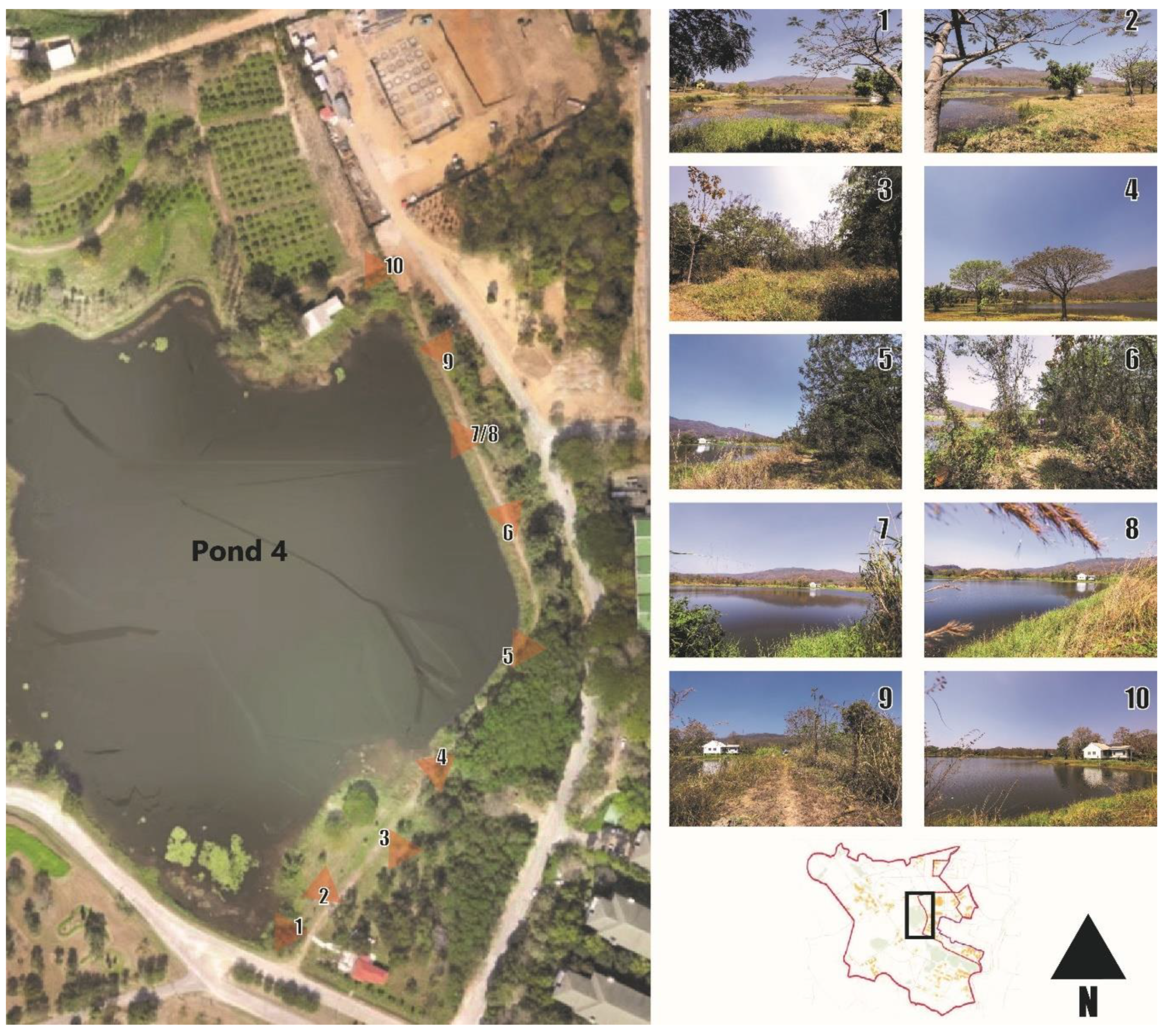
Aesthetic potential: Rai Mae-Hia offered many beautiful spots. One can enjoy many sceneries including the classic views of Suthep Mountain over the rice fields, especially during sunrise and sunset and large reservoirs across the site (Figure 2). However, weeds and signs of neglect were shown throughout the site. If the site is to have the full aesthetic potential, maintenance strategies must be applied;
-
Complicated and organic systems: Throughout its development, Rai Mae-Hia grew and developed organically by the contribution of all its organizations. The evidence was clear through its blurred boundaries and separated centers throughout the site, creating delicate webs of connections and complicated structures. However, the development with insufficient communication had created a system that lacked important connection throughout the site, such as, for example, transportation issues and collaborations between adjacent sites;
-
Lack of maintenance and monitoring: Due to its complicated system and limited budget, many locations of Rai Mae-Hia lacked proper monitoring and maintenance. Few people at the site knew the ownership of the areas across the site, and the records about where the amenities, facilities, and infrastructures are were inaccessible. In the future, the research team suggest the importance of developing a maintenance and monitoring system for future design.
The land uses of the site, based on the on-site observation and interview, are created and recorded as shown in Figure 3.
After examining the current land uses, we confirmed that the land uses highly differed from the existing one. The existing uses were more fractured and disconnected than the proposed master plan. (Figure 4).

3.1.2. Results from Stakeholder Interviews

For the initial interviews, we conducted nine individual interviews with the heads of the organizations, three interviews with the representatives, and six focus groups. For the follow-up interviews, we conducted additional 21 individual interviews.
There were roughly three levels of perceived involvement with the site from the different organizations (Figure 5). The organization with highest levels of perceived involvement included the Department of Animal and Aquatic Sciences, the Department of Highland Agriculture and Natural Resources, the Division of Horticulture, the Division of Agronomy, and the Multiple Cropping Center. These groups identified their involvement, having multiple experimental projects and staff stationed on site. They were responsible for the large areas of land and were active in using and maintaining them. They were sensitive to any changes made to the site.
The organizations with medium levels of perceived involvement included Rai Mae-Hia itself, the Faculty of Agriculture Student Union, the Division of Soil Sciences, the Department of Entomology and Plant Pathology, the Postharvest Technology Research Center, and the Highland Research and Training Center. These organizations have some facilities on site but are mostly involved with passive maintenance and running small operations. They were interested in changing the site, but they felt that they had not been involved in the decision-making process as much as they would like. These organizations were receptive toward the site changes, but not sensitive.
The organizations with low levels of perceived involvement included the Faculty of Agriculture Administrative Team, the Agricultural Technology Services Center, the Department of Agricultural Economics and Development, and the Faculty of Agriculture Alumni Association. These groups do not have permanent facilities in Rai Mae-Hia, and would like to be more involved in the future.
Three themes of changes in Rai Mae-Hia consistently emerged during the initial interviews: Technology, Public Engagement, and Centralization. The strength of the feelings toward these themes for each organization is shown in Figure 5.
The theme of technology included the discussion about the extent to which we should use technology to replace labor. Most organizations felt strongly about the issue. While some believed that technology cannot replace human labor for common agricultural practices, others, such as the Division of Horticulture, noted that the highly precise practice in the experiments cannot be replaced with machines, especially with reasonable tradeoffs. Some organizations, such as the Rai Mae-Hia Center, saw the issue on a case-by-case basis and noted that hiring engineers for technological maintenance may cost more than usual labor. Some organizations, such as the Multiple Cropping Center, however, saw it as an inevitable change and saw Rai Mae-Hia as one of the first few places to explores the possibilities of new technological advancement.
The theme of public engagement included the discussion about the extent to which Rai Mae-Hia should be open to non-researchers and outside visitors. The Department of Entomology and Plant Pathology was against the idea of public visits due to safety, citing trespassers and possible crimes towards students. It was noteworthy that all organizations in the Low-Involvement group agreed that Rai Mae-Hia should open at least some parts to public use and visits, while the High-Involvement group remained neutral about the issues, expressing concerns about their experiments being compromised by littering, intrusions, or pathogens that were carried by outside visitors.
The theme of centralization included the discussion about the extent to which the organizations should be tracked and managed as one unit. While the High-Involvement group preferred that the management be decentralized, as they were, they admitted that there were needs for systems to understand overall pictures of the site. The other groups were either neutral or fully supported the centralization of the place for fluid changes in responsibilities such as if the facilities were to be used in the future.
The overall observation of these trends suggested that the units that were already highly involved with the site were likely to want to keep the site in the same ways. Those with medium engagement were likely to want a transformation of the site administration. Those with low engagements are neutral or supportive of the changes in other aspects of the site but wanted to open the site to the public.
During the interviews, the research team asked the units about what requirements their experiments and project had so that the site can be designed to better fit the projects. However, the responses predominantly showed that, because each project lasted for only a few years at a time, the requirements change consistently, and the design ought to focus on the adaptability and availability of basic resources and infrastructure.
In terms of what they want from Rai Mae-Hia, there were two dimensions along which the participants expressed their needs and wants: policy and physical.
The policy dimension concerned the ways in which Rai Mae-Hia should be managed and what decisions should be made. The most popular patterns are marketing and income generation, clear management strategies, and workforce. The general idea was that Rai Mae-Hia’s policies needed to focus more on public relations and income generation, stronger and clearer directions, and human resources. Other issues, including related laws and clear boundaries between organizations, were expressed, but were not viewed as the biggest concerns. The patterns and numbers of the participants who mentioned them are shown in Table 2.
The physical dimension was about what Rai Mae-Hia should provide in order for it to be successful in the eyes of the interviewees. The most popular patterns are amenities and infrastructure, safety, and public use (both yes and no). The general idea was that Rai Mae-Hia’s physical features needed more accommodations, such as toilet, internet, lights, security, and public transportation. The patterns and numbers of the participants who mentioned them are shown in Table 3.
The results suggest that the involved organizations wished to develop some marketing plan and strategies for the site development direction if there was one, and that among the physical needs of the site, infrastructure and safety are top priorities.

3.2. Design

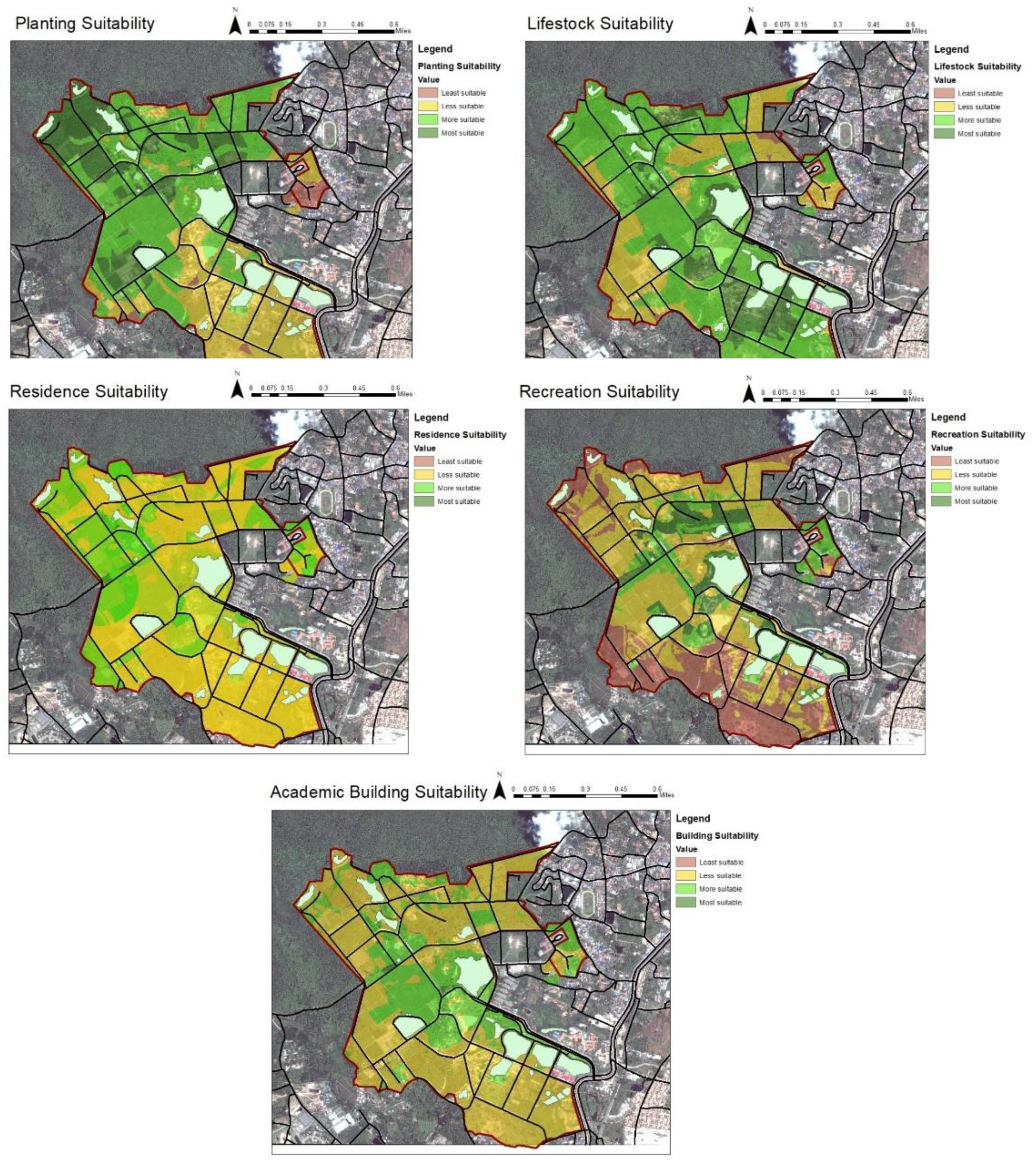
3.2.1. Suitability Analysis

From the interview, existing information from the literature, and the 1987 master plan, the suitability analysis for five sites are calculated into percentages as shown in Figure 6.
After running the analysis, the suitability of the five sites are shown as follows (Figure 7):
-
Residence: The most suitable areas for residence is connected to the entrance, the conference hall, and the existing dormitories;
-
Plant production and research: The most suitable area for plant production and research site is on the west and north east of Rai Mae-Hia, which mimics the existing land use;
-
Livestock production and research: Suitable areas for livestock are spread across the site, but the most suitable ones are at the southeast area and growing towards the northeast area of Rai Mae-Hia;
-
Academic and administration buildings: The most suitable areas for academic and administration buildings are close to the main road at the center of Rai Mae-Hia, the existing research station for the Department of Plant and Soil Sciences, and the existing conference hall;
-
Recreation: The most suitable area for recreation is next to the main road, at the waterfront, and near Pond 3.

3.2.2. Site Placement

The design-researchers had planned the site according to the survey, interviews, and suitability analysis (Figure 8).

3.3. Evaluation

Overall, the administrative team was satisfied with the preliminary survey and zoning and expressed that they would consider adding the design suggestions to the policy of Rai Mae-Hia. They saw that this zoning plan was helpful for planning the collaborations and activities within Rai Mae-Hia. The team encouraged future research into the more detailed masterplan, which would allow the development of the site and the vision of the organization, namely Go for Smart Agriculture. The design feedback from the administrative team can be categorized in the three following themes.

3.3.1. Application

Many members of the executive team expected the completed design plan and expressed their disappointment when they learned that only the zoning plan was presented. However, most understood that many group and executive decisions were needed before Rai Mae-Hia could continue into a more detailed stage of landscape planning. However, suggestions were made to the research team that they should provide 2–3 scenarios, which explained short-term, middle-term, and long-term changes based on feasible decisions of the executive team to inform their decisions in the future.

3.3.2. Flexibility

Members, especially those involved with research projects, were satisfied with the level of flexibility and resilience the research team offered to the site. Because Rai Mae-Hia is being used by several organizations, the physical planning and policies of Rai Mae-Hia are constantly evolving. Even between the beginning of the analysis and its end, new research projects and site developments are being added to the site. Thus, the suitability analysis and general suggestions offered were viewed as satisfactory.

3.3.3. Equality

While members of the executive team agree that the researchers reached out to as many participants as we could and the results reflected Rai Mae-Hia in novel lights, some input from other groups may be needed for future development of the project, including the following:
-
Stakeholders current involvement: some stakeholders are already using the site; thus, they understand the issues and impact more than those who want to use the site. However, the other group within the administrative team pointed out that if the no-use stakeholders cannot fully participate, they will have fewer opportunities to use the site. Designers and non-designers should weigh the options carefully in continuing with this project;
-
Adjacent communities: Rai Mae-Hia is adjacent to several existing communities. Beyond the organizations within the site, the needs of these communities should be considered in the development of the site;
These suggestions and recommendations were noted by the research team to improve the development of the Rai Mae-Hia masterplan in the future stages.

4. Discussion

4.1. Key Findings and Contribution

In this study, the researchers used Research-by-Design method to approach a design of an agricultural research station. They found that 1) people with different levels of engagement in the site see the future of the site differently; 2) designing for agricultural experiments, requires the adaptability and availability of basic resources due to the ever-changing nature of the experimental projects; 3) stakeholders were highly interested in marketing strategies, clear vision and policy communication, and workforce management regarding the policy aspects of agricultural research center design; 4) stakeholders prioritized infrastructure, safety, and public involvement regarding the physical design of an agricultural research center design.
These findings are congruent with the existing evidence in landscape planning and landscape design. It seemed that, in order to plan deliberatively at landscape scale, the common understanding of stakeholders is important [1,16,37,38]. The landscape, in this case Rai Mae-Hia, became a stage of discourse in the governance of the site [1]. It also expanded on the common conflicts of landscape planning, such as expansion vs. withdrawing and centralization vs. marginalization. The difficulties in following the 1987 site plan and designing the current site came from the conflicts that Wondelleck and Yaffee explained as barriers in collaborative planning, including the institutional and structural barriers, competition between units, and attitudes toward the site [39].
Resilience has not been discussed at great length during the interview, even though it had been a big part of planning for agriculture [12,15]. Neither did precise planning for agricultural crop management. This incongruency may come from more pressing issues such as safety and basic infrastructure, abstraction of water, and income, as discussed in previous studies [12]. This phenomenon might draw similarity with Maslow’s pyramid of needs [40,41]. For the units to consider ecological sustainability, their basic needs must be met. However, the researchers may argue that some ecosystem services from the site’s resilience may offset some of the issues they have been facing [42,43,44].
Many issues we found were strikingly similar to the findings in the Gikongoro project. The lack of coordination between the units and direction of the site may lead to a project’s lack of improvement [3,4]. However, because of the research team’s planning directions with the site, we can apply our findings to prevent similar negative outcomes.

4.2. Design Implications

This study’s results yielded a few implications for design and planning, including the following.

4.2.1. Plan for Monitoring and Communication

Clear communications about vision, progress, and issues on the site to all involving organizations may be key to developing a site as complex as Rai Mae-Hia more effectively.

4.2.2. Prioritize Infrastructure and Safety and Their Visibility

The study suggested that Rai Mae-Hia was underutilized due to the perceived lack of safety and infrastructure. Designers and planners should consider the well-being and safety of workers and visitors as the number one priority.

4.2.3. Budget for Maintenance or Design Landscapes with Low Maintenance

Even though Rai Mae-Hia is relatively safe, the perception of safety partially derives from maintenance [45]. Designers and planners should consider maintenance strategies as a part of the design procedure.

4.2.4. Engage in Participatory Action Community Design

The feedback suggested that community engagement and participation may be needed for a project like this to be successful [46]. Designers should seek out ways to include all stakeholders in the design processes.

4.3. Limitations and Future Studies

Future research-design studies should develop ways in which all stakeholders can be reached consistently. Due to the permissions required for each organization, the research team had to use several approaches to obtain the interview data. The interview formats differed between each organization (focus group, personal, etc.) and cannot, therefore, be compared with high accuracy. Future research may develop a way to approach this issue.
Researchers should develop more measurable design items and post-occupancy evaluation. With current technology, researchers could collect measurable data from the site such as soil chemicals, water quality and quantity, temperature, estimated travel time, or vegetation covers. Likewise, they can measure the effectiveness of design via preference, stakeholders’ willingness to pay, or modeled estimation of temperature, air flow, and water quantity and quality. Researchers might work in multi-disciplinary research with scientists, engineers, or economists to develop a complete Research-by-Design study.
Researchers may focus on more specific items of the site. In this study, due to the extent of the project and limited research time, the research team could not fully develop the site design to the extent that we could get any full feedback from laypeople. Future research can focus on only one aspect of the site, such as transportation, stormwater, productivity, or ecosystem services. Such a focus would allow for better project manageability while producing measurable and communicable outcomes.
Finally, researchers should engage in more participatory action research in similar projects. The feedback from this project indicated that there must be ways in which we allow the community and stakeholders to come together and develop the design. Future research can use this tool to get more design data and valuable design feedback to develop this research method even further in the future.

5. Conclusions

Landscape planning is crucial for a project’s sustainable development. This study recorded the processes of Research-by-Design Method with the application of deliberative planning. The researchers designed and develop a zoning mater plan for Mae Hia Agricultural Research, Demonstrative, and Training Center (Rai Mae-Hia). The study confirmed challenges found in deliberative landscape planning, such as management issues, technological applications, and public involvements. It also suggested the priorities from different stakeholders for an agricultural research station, such as basic infrastructure, safety, and marketing strategies. Future research should develop ways to explore possible scenarios and more involvement with stakeholders and adjacent communities. This study contributes to the field by providing evidence and an example in a complex research method and a novel way of planning at a landscape scale. It is a small step towards developing the practice of evidence-based design in landscape architecture and planning.

Author Contributions

Conceptualization, N.C. and P.S.; Methodology, P.S.; Validation, E.Y., V.S. and N.C.; Formal Analysis, P.S and N.C.; Investigation, P.S., N.C., and C.W.; Resources, P.S.; Data Curation, P.S., N.C., and C.W.; Writing—Original Draft Preparation, P.S.; Writing—Review and Editing, N.C., E.Y., V.S., and P.S.; Visualization, C.W.; Supervision, N.C.; Project Administration, N.C.; Funding Acquisition, N.C. and P.S. All authors have read and agreed to the published version of the manuscript.

Funding

This research has been supported by Faculty of Agriculture, Chiang Mai University under the grant number R000019458.

Acknowledgments

Some archival documents had been provided by Mae-Hia Agricultural Research, Demonstrative, and Training Center. We also would like to thank Thaworn Onprapai for his mentorship on this project.

Conflicts of Interest

The authors declare no conflict of interest. The funders had no role in the design of the study; in the collection, analyses, or interpretation of data; in the writing of the manuscript, or in the decision to publish the results.

References

  1. Selman, P. Planning at the Landscape Scale; Routledge: Abingdon, UK, 2006. [Google Scholar]
  2. Steiner, F.R. The Living Landscape: An Ecological Approach to Landscape Planning; Island Press: Washington, DC, USA, 2012. [Google Scholar]
  3. Musekura, C. Assessment of Causes of the Failure of Gikongoro Agricultural Development Project; University of KwaZulu-Natal: Durban, South Africa, 2011. [Google Scholar]
  4. Niyongabo, J. Where Sustainable Agriculture means Agricultural Productivity? In The Case Study of Gikongoro in Southwestern Rwanda; Lund University: Lund, Sweden, 2004. [Google Scholar]
  5. Donovan, G.H.; Butry, D.T.; Michael, Y.L.; Prestemon, J.P.; Liebhold, A.M.; Gatziolis, D.; Mao, M.Y. The relationship between trees and human health: Evidence from the spread of the emerald ash borer. Am. J. Prev. Med. 2013, 44, 139–145. [Google Scholar] [CrossRef]
  6. Donovan, G.H.; Michael, Y.L.; Gatziolis, D.; Prestemon, J.P.; Whitsel, E.A. Is tree loss associated with cardiovascular-disease risk in the Women’s Health Initiative? A natural experiment. Health Place 2015, 36, 1–7. [Google Scholar] [CrossRef]
  7. Kondo, M.C.; Han, S.; Donovan, G.H.; MacDonald, J.M. The association between urban trees and crime: Evidence from the spread of the emerald ash borer in Cincinnati. Landsc. Urban Plan. 2017, 157, 193–199. [Google Scholar] [CrossRef] [Green Version]
  8. Hubbes, M. The American elm and Dutch elm disease. For. Chron. 1999, 75, 265–273. [Google Scholar] [CrossRef] [Green Version]
  9. Adedayo, V. Poultry waste management techniques in urban agriculture and its implications: A case of metropolitan Lagos, Nigeria. Asian J. Agric. Sci. 2012, 4, 258–263. [Google Scholar]
  10. Meseko, C.; Odaibo, G.; Olaleye, D. Detection and isolation of 2009 pandemic influenza A/H1N1 virus in commercial piggery, Lagos Nigeria. Vet. Microbiol. 2014, 168, 197–201. [Google Scholar] [CrossRef] [PubMed]
  11. Lee, Y. Cheonggyechon Restoration and Urban Development; Kōchi University: Kochi, Japan, 2005. [Google Scholar]
  12. Selman, P. Sustainable Landscape Planning: The Reconnection Agenda; Routledge: Abingdon, UK, 2012. [Google Scholar]
  13. Redman, C.L.; Kinzig, A.P. Resilience of past landscapes: Resilience theory, society, and the longue durée. Conserv. Ecol. 2003, 7, 14. [Google Scholar] [CrossRef] [Green Version]
  14. Naveh, Z. Introduction to the theoretical foundations of multifunctional landscapes and their application in transdisciplinary landscape ecology. In Multifunctional Landscapes. Interdisciplinary Approaches to Landscape Research and Management; Centre for Landscape Research: Roskilde, Denmark, 2000; pp. 27–43. [Google Scholar]
  15. Naveh, Z. Multifunctional, self-organizing biosphere landscapes and the future of our Total Human Ecosystem. World Futures 2004, 60, 469–502. [Google Scholar] [CrossRef]
  16. Randolph, J. Environmental Land use Planning and Management; Island Press: Washington, DC, USA, 2004. [Google Scholar]
  17. Collins, M.G.; Steiner, F.R.; Rushman, M.J. Land-use suitability analysis in the United States: Historical development and promising technological achievements. Environ. Manag. 2001, 28, 611–621. [Google Scholar] [CrossRef]
  18. Parr, D.M.; Trexler, C.J.; Khanna, N.R.; Battisti, B.T. Designing sustainable agriculture education: Academics’ suggestions for an undergraduate curriculum at a land grant university. Agric. Hum. Values 2007, 24, 523–533. [Google Scholar] [CrossRef]
  19. Pretty, J.N. Alternative systems of inquiry for a sustainable agriculture. IDS Bull. 1994, 25, 37–49. [Google Scholar] [CrossRef] [Green Version]
  20. Krishna, R.; Kalpana, S. Utilization in agricultural and related fields; a better alternative for ecofriendly maintenance of Coal Fly Ash. J. Chem. Pharm. Res. 2010, 2, 365–372. [Google Scholar]
  21. Lenzholzer, S.; Duchhart, I.; Koh, J.J.L.; Planning, U. ‘Research through designing’ in landscape architecture. Landsc. Urban Plan. 2013, 113, 120–127. [Google Scholar] [CrossRef]
  22. Milburn, L.-A.S.; Brown, R.D.; Mulley, S.J.; Hilts, S.G.J.L.; Planning, U. Assessing academic contributions in landscape architecture. Landsc. Urban Plan. 2003, 64, 119–129. [Google Scholar] [CrossRef] [Green Version]
  23. Chareonlertthanakij, N.; Yaipimol, E.; Surinseng, W.; Suppakittpaisarn, P. Residential garden as green infrastructure: A research-by-design case study in Chiang Mai. In Proceedings of the I International Symposium on Botanical Gardens and Landscapes, Bangkok, Thailand, 2–4 December 2019. [Google Scholar]
  24. Milburn, L.-A.S.; Brown, R.D.J.L.; Planning, U. The relationship between research and design in landscape architecture. Landsc. Urban Plan. 2003, 64, 47–66. [Google Scholar] [CrossRef] [Green Version]
  25. Gu, Y.; Deal, B.; Larsen, L. Geodesign Processes and Ecological Systems Thinking in a Coupled Human-Environment Context: An Integrated Framework for Landscape Architecture. Sustainability 2018, 10, 3306. [Google Scholar] [CrossRef] [Green Version]
  26. Dyball, R.; Newell, B. Understanding Human Ecology: A Systems Approach to Sustainability; Routledge: Abingdon, UK, 2014. [Google Scholar]
  27. Deming, M.E.; Swaffield, S. Landscape Architectural Research: Inquiry, Strategy, Design; John Wiley & Sons: Champaign, IL, USA, 2011. [Google Scholar]
  28. Ziesel, J. Inquiry by Design: Environment/ Behavior/Neurosciences in Architecture, Interiors, Landscape, and Planning; W.W. Norton & Company: New York, NY, USA, 2006. [Google Scholar]
  29. Waterman, T. The Fundamentals of Landscape Architecture; Bloomsbury Publishing: London, UK, 2015. [Google Scholar]
  30. Marcus, C.C.; Francis, C. People Places: Design Guidelines for Urban Open space; Van Nostrand Reinhold: New York, NY, USA, 1997. [Google Scholar]
  31. Pierce, R. Evaluating information: Validity, reliability, accuracy, triangulation. In Research Methods in Politics: A Practical Guide; Sage Publications: Edmonton, AB, Canada, 2008. [Google Scholar]
  32. Bossard, E.G.; Hobbs, J.; Hondorp, B.; Kelly, T.; Plembaeck, S.; Salazar, D.; Subotic, A.; Taketa, R.; Tran, T.; Wang, P.Y.; et al. Envisioning Neighborhoods with Transit Oriented Development Potential. In The Mineta Transportation Institute; San Jose State University: San Jose, CA, USA, 2002. [Google Scholar]
  33. Lynch, K.; Lynch, K.R.; Hack, G. Site Planning; MIT Press: Cambridge, MA, USA, 1984. [Google Scholar]
  34. Kaplan, R.; Kaplan, S.; Ryan, R.L. With People in Mind: Design and Management of Everyday Nature/Rachel Kaplan, Stephen Kaplan, and Robert L. Ryan; Island Press: Washington, DC, USA, 1998. [Google Scholar]
  35. QGIS. QGIS Geographic Information System Version 3.6; Open Source Geospatial Foundation: Beaverton, OR, USA, 2009. [Google Scholar]
  36. Department of Public Works and Town & Country Planning. Master Plan of Mae-Hia Agricultural Research, Demonstrative, and Training Center (ผังแม่บทศูนย์วิจัย สาธิต และฝึกอบรมการเกษตรแม่เหียะ); Department of Public Works and Town & Country Planning: Chiang Mai, Thailand, 1987.
  37. American Planning Association. Planning and Urban design Standards; John Wiley & Sons: Hoboken, NJ, USA, 2006. [Google Scholar]
  38. Corburn, J. Toward the Healthy City: People, Places, and the Politics of Urban Planning; Mit Press: Cambridge, MA, USA, 2009. [Google Scholar]
  39. Wondolleck, J.M.; Yaffee, S.L. Making Collaboration Work: Lessons from Innovation in Natural Resource Managment; Island Press: Washington, DC, USA, 2000. [Google Scholar]
  40. Wahba, M.A.; Bridwell, L.G. Maslow reconsidered: A review of research on the need hierarchy theory. Organ. Behav. Hum. Perform. 1976, 15, 212–240. [Google Scholar] [CrossRef]
  41. Heylighen, F. A cognitive-systemic reconstruction of maslow’s theory of self-actualization. Behav. Sci. 1992, 37, 39–58. [Google Scholar] [CrossRef]
  42. Coutts, C.; Hahn, M. Green Infrastructure, Ecosystem Services, and Human Health. Int. J. Environ. Res. Public Health 2015, 12, 9768–9798. [Google Scholar] [CrossRef] [Green Version]
  43. Tscharntke, T.; Klein, A.M.; Kruess, A.; Steffan-Dewenter, I.; Thies, C. Landscape perspectives on agricultural intensification and biodiversity–ecosystem service management. Ecol. Lett. 2005, 8, 857–874. [Google Scholar] [CrossRef]
  44. Carpenter, S.R.; Mooney, H.A.; Agard, J.; Capistrano, D.; DeFries, R.S.; Díaz, S.; Dietz, T.; Duraiappah, A.K.; Oteng-Yeboah, A.; Pereira, H.M. Science for managing ecosystem services: Beyond the Millennium Ecosystem Assessment. Proc. Natl. Acad. Sci. USA 2009, 106, 1305–1312. [Google Scholar] [CrossRef] [Green Version]
  45. Nassauer, J.I. Care and stewardship: From home to planet. Landsc. Urban Plan. 2011, 100, 321–323. [Google Scholar] [CrossRef]
  46. Churchman, A.; Sadan, E. Public Participation in Environmental Design and Planning. In Encyclopedia of Applied Psychology; Spielberger, C., Ed.; Elsevier: Oxford, UK, 2004; pp. 793–800. [Google Scholar]
Figure 1. Stakeholders outside of the Faculty of Agriculture within the Rai Mae-Hia boundary.
Land 09 00149 g001
Figure 2. Example of site investigation report, showing beautiful sceneries next to Pond 4, but at the same time showing some overgrown vegetation and swales.
Land 09 00149 g002
Figure 3. Land use of the site based on site observation and interview between August 2018 and September 2019.
Land 09 00149 g003
Figure 4. The comparison between the 1987 proposed masterplan and the surveyed land uses.
Land 09 00149 g004
Figure 5. Involvement of the organizations and their opinions about three main themes of changes. The closer to the center, the more they are against these changes.
Land 09 00149 g005
Figure 6. The suitability analysis criteria.
Land 09 00149 g006
Figure 7. Suitability analysis for each land use needed.
Land 09 00149 g007
Figure 8. Zoning results of suitability analysis.
Land 09 00149 g008
Table 1. Items of interests between the different levels of involvement and expertise (developed from Selman (2006) and Parr et. al, 2007 [1,18]).
More InvolvedLess Involved (but also often Valued by those Involved)
Lay-peoplequality of liferecreation and tourism
memories and associationsscenic beauty
safetyexperiences at the site
symbolsarchitectural significance
living spacesafe foods
Expertsproduction and maintenanceterritory acquisition
facilities and servicesbiodiversity and environmental service functions
natural resources conservationcollaboration opportunities
knowledge gained through research
Table 2. Policy-related theme from the groups.
KeywordGroupRep.IndividualTotalCommon Expressions (Paraphrased)
692439
Marketing and income generation481123Marketing plan is needed
Clear management strategies421218We do not know/ have not planned the strategies of the site as a whole
Lack of workforce231318We have limited work force due to budget issues
Usage rights and other laws 3429We are not sure what can/ cannot be legally done to the site
Clear physical and management boundaries2237We are not sure if the area(s) belongs to us or other organization
Table 3. Physical-related theme from the groups.
KeywordGroupRep.IndividualTotalCommon Expressions
692439
Amenities and infrastructure441826We are not sure where the infrastructure and amenities (such as restrooms) are
Safety431118We feel a bit unsafe after dark. It needs more security and lighting
Open to public use33915The place should be more accommodating for public use
Learning center411015A learning center might help increase the use of this place
Better links between zones32914Sometimes the layout of the site could be more connected
Aesthetics33511The view is great, but the site itself needs to be more beautiful
Wayfinding21811We sometimes got lost in the site
Technological application13610We want to see more technological engagement on the site
Agritourism43310This site has a potential for agritourism
Pest management2079We don’t have enough resources to manage weeds and grasses on site
Transportation1078There is no public transportation within the site
Demonstrative business4037It would be nice to have some more demonstrative business on site
Common area for staff and students1236We do not have places to rest after working on the field
Demonstrative Smart Farm1146The place should have a demonstrative smart farm
Continuous research projects0066Sometimes the field is empty for a long time after a research project is completed
Central laboratory1135A central laboratory would be a great opportunity for the site

