Next Issue
Volume 9, June
Previous Issue
Volume 9, April


Land, Volume 9, Issue 5 (May 2020) – 43 articles

Cover Story (view full-size image): 
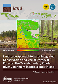
Primeval, primary, virgin and naturally dynamic are some of the ways to describe forests with a high degree of naturalness. Intact forest landscapes (top map) with these characteristics are globally recognised for their importance. These forests sustain species, their habitats and the processes that maintain them; store and sequester carbon; and provide opportunities for rural development. The border between the European Union and the Russian Federation illustrates the consequences of different landscape histories for rural development (centre map). This study of the transboundary Kovda River catchment (in blue) stresses the need for an integrated landscape approach that encompasses restoration and conservation of forest ecosystem services, as well as adaptive multilevel governance of rural landscapes. Transboundary collaboration offers opportunities for transdisciplinary knowledge production and [...] Read more.
  • Issues are regarded as officially published after their release is announced to the table of contents alert mailing list.
  • You may sign up for e-mail alerts to receive table of contents of newly released issues.
  • PDF is the official format for papers published in both, html and pdf forms. To view the papers in pdf format, click on the "PDF Full-text" link, and use the free Adobe Reader to open them.
Order results
Result details
Section
Select all
Export citation of selected articles as:
20 pages, 586 KiB  
Article
Old Ways, New Ways—Scaling Up from Customary Use of Plant Products to Commercial Harvest Taking a Multifunctional, Landscape Approach
by Julian Gorman, Diane Pearson and Penelope Wurm
Land 2020, 9(5), 171; https://doi.org/10.3390/land9050171 - 25 May 2020
Cited by 9 | Viewed by 4282
Abstract
Globally, the agricultural sector is facing many challenges in response to climate change, unsustainable farming practices and human population growth. Despite advances in technology and innovation in agriculture, governments around the world are recognizing a need for transformative agricultural systems that offer solutions [...] Read more.
Globally, the agricultural sector is facing many challenges in response to climate change, unsustainable farming practices and human population growth. Despite advances in technology and innovation in agriculture, governments around the world are recognizing a need for transformative agricultural systems that offer solutions to the interrelated issues of food security, climate change, and conservation of environmental and cultural values. Approaches to production are needed that are holistic and multisectoral. In planning for future agricultural models, it is worth exploring indigenous agricultural heritage systems that have demonstrated success in community food security without major environmental impacts. We demonstrate how indigenous practices of customary harvest, operating in multifunctional landscapes, can be scaled up to service new markets while still maintaining natural and cultural values. We do this through a case analysis of the wild harvest of Kakadu plum fruit by Aboriginal people across the tropical savannas of northern Australia. We conclude that this system would ideally operate at a landscape scale to ensure sustainability of harvest, maintenance of important patterns and processes for landscape health, and incorporate cultural and livelihood objectives. Applied to a variety of similar native products, such a production system has potential to make a substantial contribution to niche areas of global food and livelihood security. Full article
(This article belongs to the Special Issue Multiple Roles for Landscape Ecology in Future Farming Systems)
Show Figures

Figure 1

22 pages, 7428 KiB  
Article
Spatio-Temporal Coordination and Conflict of Production-Living-Ecology Land Functions in the Beijing-Tianjin-Hebei Region, China
by Zhuxiao Yu, Erqi Xu, Hongqi Zhang and Erping Shang
Land 2020, 9(5), 170; https://doi.org/10.3390/land9050170 - 23 May 2020
Cited by 29 | Viewed by 3346
Abstract
Assessment of multiple land use functions promotes both utilization efficiency of land and regional coordination. Different personal and public products and services are offered by various land use types, meaning their functionality varies. Lack of judgment on temporal trends, turning points, or consideration [...] Read more.
Assessment of multiple land use functions promotes both utilization efficiency of land and regional coordination. Different personal and public products and services are offered by various land use types, meaning their functionality varies. Lack of judgment on temporal trends, turning points, or consideration of multi-source indicators like the ecological and air quality index leads to uncertainties in urban multifunctionality evaluation and functional orientation. In this study, the production-living-ecology land use function index system and evaluation process was improved using an entropy weight, triangle model, and coupling coordination degree. The production-living-ecology land use function (PLELUF) is defined from land use multi-functions. The Beijing-Tianjin-Hebei urban agglomeration was the representative area. The model was applied to quantify land use functions and measure spatio-temporal coordination and conflict from 1990 to 2015. Results found that the production and living functions displayed an overall upward trend and the growth rate of production function is larger, doubling from 1990 to 1995, while living function increases steadily. Ecology function remained steady from 1990 to 2000 but increased afterward. Land use function stage became balanced in ecology-living-production after 2005. No function-balanced cities existed in 1990; nine function-balanced cities were found in 2015. The coupling coordination degree increased from a slight conflict to a high coordination. Land use multi-functionality was high in the north and low in the south in 2015; Beijing had the most significant multifunctionality. This study can aid land use zoning and sustainable land management. Full article
(This article belongs to the Section Land Systems and Global Change)
Show Figures

Graphical abstract

13 pages, 750 KiB  
Article
Spatial Planning, Urban Governance and the Economic Context: The Case of ‘Mehr’ Housing Plan, Iran
by Saeed Zanganeh Shahraki, Narges Ahmadifard, Hossein Farhadikhah, Bagher Fotouhi Mehrabani, Asghar Haydari, Yaghob Abdali, Vahid Abbasi Fallah, Ebrahim Farhadi, Sirio Cividino, Sabato Vinci and Luca Salvati
Land 2020, 9(5), 169; https://doi.org/10.3390/land9050169 - 22 May 2020
Cited by 14 | Viewed by 3032
Abstract
With the increasing concentration of population and economic activities in metropolitan regions, dwelling shortages and housing quality have become critical issues in urban management. Town plans considering social, economic, political, and cultural features of local communities have been developed with the aim of [...] Read more.
With the increasing concentration of population and economic activities in metropolitan regions, dwelling shortages and housing quality have become critical issues in urban management. Town plans considering social, economic, political, and cultural features of local communities have been developed with the aim of supporting housing, especially in emerging economies. In Iran, the ‘Mehr Housing’ Plan has been considered as one of the most relevant strategies for social housing since the 2000s. However, the acceptance of ‘Mehr Housing’ plans at the community scale has been rather low, reflecting the fact that it is a top-down, non-participatory policy. The present study investigates the most important factors affecting social acceptance of ‘Mehr Housing’ plans by interviewing 45 experts through a structured questionnaire that evaluated multiple analyses’ dimensions of housing and urban planning in Iran. Results showed that six dimensions (physical, institutional-managerial, economic, socio-cultural, legal, and locational) had contributed to social dissatisfaction with ‘Mehr Housing’ local initiatives. In particular, socio-cultural and legal dimensions were demonstrated to have a large impact on local communities’ dissatisfaction. Full article
(This article belongs to the Section Urban Contexts and Urban-Rural Interactions)
Show Figures

Figure 1

21 pages, 2773 KiB  
Article
Who Remains When Professional Farmers Give up? Some Insights on Hobby Farming in an Olive Groves-Oriented Terraced Mediterranean Area
by Sabine Gennai-Schott, Tiziana Sabbatini, Davide Rizzo and Elisa Marraccini
Land 2020, 9(5), 168; https://doi.org/10.3390/land9050168 - 22 May 2020
Cited by 10 | Viewed by 4016
Abstract
Many land use systems in Mediterranean sloping areas risk abandonment because of nonprofitability, while their hydro-geological stability depends on an appropriate management. However, who are the land managers? What are their practices? Our research on the traditional olive groves of the Monte Pisano [...] Read more.
Many land use systems in Mediterranean sloping areas risk abandonment because of nonprofitability, while their hydro-geological stability depends on an appropriate management. However, who are the land managers? What are their practices? Our research on the traditional olive groves of the Monte Pisano (Tuscany, Italy) reveals for the first time the quantitatively important role of hobby farmers as land managers in the area. We used a three-step-method: first, a database was constructed using several data sources to identify and map the population of olive growers; then, 35 semi-structured interviews were conducted, and finally, the data were analyzed to highlight the contribution of olive growers to the land management, along with their motivations and constraints. Our results found that hobby farmers constitute about 90% of all land managers in the study area and manage more than half of the agricultural land. They are a very uneven group, and there are no clear categories detectable by analyzing sociodemographic factors, practices and farm characteristics. They are the “same but different”, not following any market rules, as they are not profit-oriented. Their farming practices are quite homogeneous and mainly in-line with professional farming practices of that area, oriented versus a minimum input management. Full article
Show Figures

Figure 1

13 pages, 494 KiB  
Review
The Rush for Land and Agricultural Investment in Ethiopia: What We Know and What We Are Missing
by Logan Cochrane and Danielle D. Legault
Land 2020, 9(5), 167; https://doi.org/10.3390/land9050167 - 22 May 2020
Cited by 25 | Viewed by 4682
Abstract
More than a decade has passed since the triple crises of food, energy and finance in the period 2007–2008. Those events turned global investor interest to agriculture and its commodities and thereafter the leasing of tens of millions of hectares of land. This [...] Read more.
More than a decade has passed since the triple crises of food, energy and finance in the period 2007–2008. Those events turned global investor interest to agriculture and its commodities and thereafter the leasing of tens of millions of hectares of land. This article reviews and synthesizes the available evidence regarding the agricultural investments that have taken place in Ethiopia since that time. We use a systematic review approach to identify literature from the Web of Science and complement that with additional literature found via Google Scholar. Qualitative and quantitative methods are used to analyze the available literature. In so doing, we raise questions of data quality, by analyzing the evidence base used by many studies (the Land Matrix database) and compare it with data we obtained from the Government of Ethiopia. We find that while the Land Matrix is the largest available database, it appears to present only a fraction of the reality. In critically assessing the literature, we identify areas that have been under-researched or are missing from the literature, namely assessments of gendered impacts, the role of diaspora and domestic investors, interdisciplinary approaches (e.g., integrating climate change, biodiversity, and water), and studies that move beyond technical assessment, such as looking at the impacts on traditional knowledge and socio-cultural systems. Full article
(This article belongs to the Special Issue Land Rush in Africa)
Show Figures

Figure 1

20 pages, 6084 KiB  
Article
Land Cover and Land Use Change in the US Prairie Pothole Region Using the USDA Cropland Data Layer
by Woubet G. Alemu, Geoffrey M. Henebry and Assefa M. Melesse
Land 2020, 9(5), 166; https://doi.org/10.3390/land9050166 - 21 May 2020
Cited by 11 | Viewed by 3741
Abstract
The Prairie Pothole Region (PPR) is a biotically important region of grassland, wetland, and cropland that traverses the Canada-US border. Significant amounts of grasslands and wetlands within the PPR have been converted to croplands in recent years due to increasing demand for biofuels. [...] Read more.
The Prairie Pothole Region (PPR) is a biotically important region of grassland, wetland, and cropland that traverses the Canada-US border. Significant amounts of grasslands and wetlands within the PPR have been converted to croplands in recent years due to increasing demand for biofuels. We characterized land dynamics across the US portion of the PPR (US–PPR) using the USDA Crop Data Layer (CDL) for 2006–2018. We also conducted a comparative analysis between two epochs (1998–2007 & 2008–2017) of the CDL data time series in the North Dakotan portion of the US–PPR. The CDL revealed the western parts of the US–PPR have been dominated by grass/pasture, to the north it was spring wheat, to the east and southern half, soybeans dominated, and to the south it was corn (maize). Nonparametric trend analysis on the major crop and land cover types revealed statistically significant net decreases in the grass/pasture class between 2006 and 2018, which accounts for more than a quarter of grass/pasture area within the US–PPR. Other crops experiencing significant decreases included sunflower (-5%), winter wheat (-3%), spring wheat (-2%), and durum wheat (-1%). The combined coverage of corn and soybeans exhibited significant net increases in 23.5% of its cover; whereas, the individual significant net increases were 5% for corn and 11% for soybeans. Hotspots of increase in corn and soybeans were distributed across North and South Dakota. Other crop/land covers with huge significant increases include other hay/non-alfalfa (15%), and alfalfa (11%), which appear to be associated with the sharp increase in larger dairy operations, mostly in Minnesota. Wetland area increased 5% in the US–PPR, due to increased precipitation as well as inundation associated with Devils Lake in North Dakota. Hotspots of decreasing grass/pasture area were evident across the study area. Comparative trend analysis of two epochs (1998–2007 vs. 2008–2017) in North Dakota revealed that grass/pasture cover showed a negligible net trend (-0.3 %) between 1998 and 2007; whereas, there was a statistically significant decrease of more than 30% between 2008 and 2017. Combined coverage of corn and soybeans experienced statistically significant net increases in both epochs: 11% greater during 1998–2007 and 17% greater during 2008–2017. Recent sharp losses of grasslands and smaller wetlands combined the expansion of corn, soybeans, and alfalfa bode ill for wildlife habitat and require a re-examination of agricultural and energy policies that have encouraged these land transitions. Full article
Show Figures

Graphical abstract

17 pages, 11349 KiB  
Article
Historical-Genetic Features in Rural Settlement System: A Case Study from Mogilev District (Mogilev Oblast, Belarus)
by Elena Gorbenkova and Elena Shcherbina
Land 2020, 9(5), 165; https://doi.org/10.3390/land9050165 - 21 May 2020
Cited by 15 | Viewed by 3438
Abstract
Settlement system development is currently one of the basic objectives in land use planning, which is significant for Belarus, as it is the most urbanized country in the European region. Historical-genetic analysis is the most effective approach for studying the transformational changes in [...] Read more.
Settlement system development is currently one of the basic objectives in land use planning, which is significant for Belarus, as it is the most urbanized country in the European region. Historical-genetic analysis is the most effective approach for studying the transformational changes in settlement systems. The research was aimed at analyzing the transformation peculiarities in the rural settlement system of Belarus. The core of the methodological basis lies in general scientific methods (systematic approach, historicism approach, historical-genetic method) and special interdisciplinary methods (cartographic analysis using GIS software). Historical-genetic analysis made it possible to identify the most significant historical periods in the formation of the rural settlement system in Belarus: pre-revolutionary, Soviet and recent. For each period, the pattern and spatial configuration of the rural settlement system were analyzed. Spatial changes in settlement pattern were highlighted: polarization, increasing the share and the population number of the “largest” settlements, the decreasing of “large” and “medium-sized” settlements and the degradation of “small” settlements. As a result, two types of rural settlement transformation were identified: “development” and “degradation”. Three ways of spatial configuration of the rural settlement system were identified: “relocation to city”, “relocation to the center of the settlement system” and “relocation to settlement”. Directions for future research are linked with conceptualizing the model of the spatial–territorial organizing of the rural settlement system. Full article
Show Figures

Figure 1

13 pages, 1049 KiB  
Article
Effect of Herbage Density, Height and Age on Nutrient and Invertebrate Generalist Predator Abundance in Permanent and Temporary Pastures
by Rémi Toupet, Alastair T. Gibbons, Sara L. Goodacre and Matt J. Bell
Land 2020, 9(5), 164; https://doi.org/10.3390/land9050164 - 21 May 2020
Cited by 6 | Viewed by 2253
Abstract
The aim of this research was to assess differences in the quantity and quality of herbage and invertebrate generalist predator abundance among permanent and temporary pastures. Two permanent pastures and four temporary ley pastures (either one year or two years since being sown) [...] Read more.
The aim of this research was to assess differences in the quantity and quality of herbage and invertebrate generalist predator abundance among permanent and temporary pastures. Two permanent pastures and four temporary ley pastures (either one year or two years since being sown) were monitored weekly for 10 weeks in the spring. Permanent pastures included a diverse range of native UK grass species, and temporary ley pastures were predominantly perennial ryegrass (Lolium perenne) with or without white clover (Trifolium repens). Weekly measurements of herbage height (in centimeters), herbage cover (fresh and dry matter in kg per hectare) and herbage density (fresh and dry matter in kg per hectare per centimeter) were obtained for each field, along with lycosid spider and carabid beetle abundance. Weekly pasture samples were used to obtain nutrient concentrations of dry matter, crude protein, neutral detergent fibre (NDF), acid detergent fibre (ADF), ash, oil, sugars, digestible organic matter in the dry matter (DOMD) and metabolisable energy (ME) in the herbage as a measure of forage quality for grazing or harvesting. A linear mixed model was used to assess the effect of sward age, herbage density and height on herbage production, nutrient concentrations and invertebrate abundance. Although this study showed that permanent pastures were associated with lower nutrient concentrations of crude protein, ash, oil and ME compared to younger and predominantly perennial ryegrass pastures, the older pastures were associated with higher carabid numbers. Furthermore, permanent pastures had a higher density of dry matter herbage compared to younger pastures, and more dense and taller swards were associated with higher lycosid numbers. The study suggests that within pastures of 3 to 20 cm height, increasing the height and density of swards increases both ME and oil concentrations in herbage, therefore enhancing forage nutrient quality. Older and more permanent pastures can be beneficial for plant and invertebrate generalist predator populations, and still provide a useful source of nutrients for forage production. Full article
(This article belongs to the Section Landscape Ecology)
Show Figures

Figure 1

25 pages, 1267 KiB  
Article
Community Development through the Empowerment of Indigenous Women in Cuetzalan Del Progreso, Mexico
by Pamela Durán-Díaz, Adriana Armenta-Ramírez, Anne Kristiina Kurjenoja and Melissa Schumacher
Land 2020, 9(5), 163; https://doi.org/10.3390/land9050163 - 20 May 2020
Cited by 15 | Viewed by 6443
Abstract
Women are an underappreciated economic force who, when empowered by association with a female organization, can be a catalyst for development. To assess the status of Indigenous rural women, as well as the mechanisms and impacts of their empowerment, this paper presents a [...] Read more.
Women are an underappreciated economic force who, when empowered by association with a female organization, can be a catalyst for development. To assess the status of Indigenous rural women, as well as the mechanisms and impacts of their empowerment, this paper presents a case study of a community development approach based on the Masehual Siuamej Mosenyolchicacauani organization in Cuetzalan del Progreso, Puebla. The methodology used is a mixed-methods approach involving a literature review of two regional instruments: The Federal Program “Pueblos Mágicos” and the Land and Environmental Management Program “POET” for Cuetzalan. It also includes geo-data collection from public sources, empirical data collection from open-ended interviews, and focus group discussions with key informants from the Indigenous organization. The research found that, despite an inclusive legal and institutional framework, weak policy implementation and certain federal programs tend to segregate Indigenous communities. Mechanisms such as cultural tourism and inclusive land management programs, capacity building initiatives, and female associations have proven useful for empowering women and have had positive socioeconomic impacts on the community. The research concluded that female Indigenous associations are a tool to empower rural women, grant them tenure security, strengthen their engagement in decision making, and consolidate them as key stakeholders in community development. Full article
(This article belongs to the Special Issue Land, Women, Youths, and Land Tools or Methods)
Show Figures

Figure 1

11 pages, 1139 KiB  
Communication
The Incremental Demise of Urban Green Spaces
by Johan Colding, Åsa Gren and Stephan Barthel
Land 2020, 9(5), 162; https://doi.org/10.3390/land9050162 - 20 May 2020
Cited by 62 | Viewed by 9832
Abstract
More precise explanations are needed to better understand why public green spaces are diminishing in cities, leading to the loss of ecosystem services that humans receive from natural systems. This paper is devoted to the incremental change of green spaces—a fate that is [...] Read more.
More precise explanations are needed to better understand why public green spaces are diminishing in cities, leading to the loss of ecosystem services that humans receive from natural systems. This paper is devoted to the incremental change of green spaces—a fate that is largely undetectable by urban residents. The paper elucidates a set of drivers resulting in the subtle loss of urban green spaces and elaborates on the consequences of this for resilience planning of ecosystem services. Incremental changes of greenspace trigger baseline shifts, where each generation of humans tends to take the current condition of an ecosystem as the normal state, disregarding its previous states. Even well-intended political land-use decisions, such as current privatization schemes, can cumulatively result in undesirable societal outcomes, leading to a gradual loss of opportunities for nature experience. Alfred E. Kahn referred to such decision making as ‘the tyranny of small decisions.’ This is mirrored in urban planning as problems that are dealt with in an ad hoc manner with no officially formulated vision for long-term spatial planning. Urban common property systems could provide interim solutions for local governments to survive periods of fiscal shortfalls. Transfer of proprietor rights to civil society groups can enhance the resilience of ecosystem services in cities. Full article
(This article belongs to the Special Issue Urban Ecosystem Services)
Show Figures

Figure 1

16 pages, 1567 KiB  
Article
Spatial Orientation Skill for Landscape Architecture Education and Professional Practice
by Carlos Carbonell-Carrera, Jose Luis Saorin and Stephany Hess-Medler
Land 2020, 9(5), 161; https://doi.org/10.3390/land9050161 - 20 May 2020
Cited by 7 | Viewed by 3494
Abstract
Professional landscape architecture organizations have requested training from educational institutions based on new skills and methodologies in the curriculum development of students. Landscape architects need to visualize and evaluate the spatial relationships between the different components of the landscape using two-dimensional (2D) or [...] Read more.
Professional landscape architecture organizations have requested training from educational institutions based on new skills and methodologies in the curriculum development of students. Landscape architects need to visualize and evaluate the spatial relationships between the different components of the landscape using two-dimensional (2D) or three-dimensional (3D) maps and geospatial information, for which spatial orientation skills are necessary. The data from six workshops conducted throughout the 2010–2020 period, in which 560 second-year engineering students participated using different strategies and technical tools for spatial orientation skills’ development, were collected in a unique study. Factors such as the technology used, the gaming environment, the type of task, the 2D/3D environment, and the virtual environment were considered. The Perspective-Taking Spatial Orientation Test was the measurement tool used. The results show that mapping tasks are more efficient than route-based tasks. Strategies using 2D and a 2D/3D combination are more effective than those with only 3D. First-person perspective gaming environments are also a valid alternative. The technologies applied in this study are easy to use and free, and a measurement tool is provided. This facilitates an interdisciplinary approach between landscape architecture education and professional practice since these workshops could also be easily carried out by professional bodies for landscape planning and management. Full article
Show Figures

Figure 1

19 pages, 2996 KiB  
Article
A Spatial-Temporal Analysis of the Effects of Households’ Land-use Behaviors on Soil Available Potassium in Cropland: A Case Study from Urban Peripheral Region in Northeast China
by Hongbin Liu, Zhanli Sun, Xiaojuan Luo, Xiuru Dong and Mengyao Wu
Land 2020, 9(5), 160; https://doi.org/10.3390/land9050160 - 20 May 2020
Cited by 5 | Viewed by 2642
Abstract
Available potassium (AVK) in the soil of cropland is one of the most important factors determining soil quality and agricultural productivity. Thus, it is crucial to understand the variation of AVK and its influencing factors for sustaining soil fertility and mitigating land degradation. [...] Read more.
Available potassium (AVK) in the soil of cropland is one of the most important factors determining soil quality and agricultural productivity. Thus, it is crucial to understand the variation of AVK and its influencing factors for sustaining soil fertility and mitigating land degradation. Farm households are the ultimate land users, and their land-use behaviors inevitably play an important role in the variation of AVK. This paper, therefore, aims to explore the effects of households’ land-use behaviors on soil AVK from spatial and temporal perspectives. Taking an urban peripheral region in Northeast China as the study area, we firstly use geostatistics (Kriging interpolation) and GIS tools to map out the spatial AVK distributions in 1980, 2000, and 2010, based on soil sampling data points, and then assess the impacts of land-use behaviors on AVK using econometric models. The results show that, although the AVK content in the study area has a largely downward trend over the 30 years, there are distinct trends in different stages. The disparity of trends can be attributed to the changes in households’ land-use behaviors over time. The spatial variation of AVK is also substantial and intriguing: the closer to the urban area, the greater the decline of soil AVK content, while the farther away from the urban area, the greater the rise of soil AVK content. This spatial disparity can too be largely explained by the obvious differences in households’ land-use behaviors in various regions. Full article
(This article belongs to the Special Issue Soil Management for Sustainability)
Show Figures

Figure 1

18 pages, 1169 KiB  
Article
Mapping Suburbs Based on Spatial Interactions and Effect Analysis on Ecological Landscape Change: A Case Study of Jiangsu Province from 1998 to 2018, Eastern China
by Yasi Tian
Land 2020, 9(5), 159; https://doi.org/10.3390/land9050159 - 19 May 2020
Cited by 17 | Viewed by 2877
Abstract
As the transitional area between urban and rural areas, land-use change in suburbs is drastic, which generates negative effects on the ecological environment. However, the identification of the suburbs remains controversial. Usually, the density of the population and residential land is referenced, and [...] Read more.
As the transitional area between urban and rural areas, land-use change in suburbs is drastic, which generates negative effects on the ecological environment. However, the identification of the suburbs remains controversial. Usually, the density of the population and residential land is referenced, and the close spatial interactions between urban areas and suburbs are generally neglected. To fill this research gap, this study adopts a case study method to map the suburbs of Jiangsu based on estimating the spatial interactions. First, a regression model is built to estimate the population distribution. Second, a radiation model is utilized to evaluate the spatial interaction at a grid level. After the main urban area is identified based on the high density of the population and construction land, the interaction strength between the main urban grid and other grid areas is calculated, and the grids that share high values of interaction strength with urban grids are identified as suburban areas. Finally, the suburbs of Jiangsu in 1998 and 2018 are mapped, and the ecological landscape pattern metrics are used to verify the effects of suburban expansion. As a result, the suburban expansion of Jiangsu over the 20 years was significant, and the effects of suburban expansion on ecological land fragmentation were evident. On the basis of the results, the enlightenment of mapping suburbs on ecological landscape planning is discussed. Full article
Show Figures

Figure 1

17 pages, 3834 KiB  
Communication
On How Crowdsourced Data and Landscape Organisation Metrics Can Facilitate the Mapping of Cultural Ecosystem Services: An Estonian Case Study
by Oleksandr Karasov, Stien Heremans, Mart Külvik, Artem Domnich and Igor Chervanyov
Land 2020, 9(5), 158; https://doi.org/10.3390/land9050158 - 19 May 2020
Cited by 22 | Viewed by 4072
Abstract
Social media continues to grow, permanently capturing our digital footprint in the form of texts, photographs, and videos, thereby reflecting our daily lives. Therefore, recent studies are increasingly recognising passively crowdsourced geotagged photographs retrieved from location-based social media as suitable data for quantitative [...] Read more.
Social media continues to grow, permanently capturing our digital footprint in the form of texts, photographs, and videos, thereby reflecting our daily lives. Therefore, recent studies are increasingly recognising passively crowdsourced geotagged photographs retrieved from location-based social media as suitable data for quantitative mapping and assessment of cultural ecosystem service (CES) flow. In this study, we attempt to improve CES mapping from geotagged photographs by combining natural language processing, i.e., topic modelling and automated machine learning classification. Our study focuses on three main groups of CESs that are abundant in outdoor social media data: landscape watching, active outdoor recreation, and wildlife watching. Moreover, by means of a comparative viewshed analysis, we compare the geographic information system- and remote sensing-based landscape organisation metrics related to landscape coherence and colour harmony. We observed the spatial distribution of CESs in Estonia and confirmed that colour harmony indices are more strongly associated with landscape watching and outdoor recreation, while landscape coherence is more associated with wildlife watching. Both CES use and values of landscape organisation indices are land cover-specific. The suggested methodology can significantly improve the state-of-the-art with regard to CES mapping from geotagged photographs, and it is therefore particularly relevant for monitoring landscape sustainability. Full article
(This article belongs to the Section Landscape Ecology)
Show Figures

Figure 1

16 pages, 606 KiB  
Article
Delivering Climate-Development Co-Benefits through Multi-Stakeholder Forestry Projects in Madagascar: Opportunities and Challenges
by Nicola Favretto, Stavros Afionis, Lindsay C. Stringer, Andrew J. Dougill, Claire H. Quinn and Hery Lisy Tiana Ranarijaona
Land 2020, 9(5), 157; https://doi.org/10.3390/land9050157 - 18 May 2020
Cited by 5 | Viewed by 5105
Abstract
This paper explores multi-stakeholder perspectives on the extent to which forestry projects that pursue ecological restoration and rehabilitation in Madagascar engage with local communities and can co-deliver climate-development benefits. Drawing on mixed methods (policy analysis, semi-structured interviews, participatory site visits and focus groups) [...] Read more.
This paper explores multi-stakeholder perspectives on the extent to which forestry projects that pursue ecological restoration and rehabilitation in Madagascar engage with local communities and can co-deliver climate-development benefits. Drawing on mixed methods (policy analysis, semi-structured interviews, participatory site visits and focus groups) in two different forestry contexts, we show that by strengthening access to capital availability, projects can enhance local adaptive capacity and mitigation and deliver local development. We show that active consideration of ecological conservation and action plans early in project design and implementation can co-develop and support monitoring and reporting systems, needed to progress towards integrated climate-compatible development approaches. Climate mitigation benefits remain poorly quantified due to limited interest in, and low capacity to generate, carbon revenues. Monitoring alone does not ensure carbon benefits will materialize, and this research stresses that institutional considerations and strengthened engagement and cooperation between practitioners and communities are key in achieving both climate mitigation and community development impacts. Multiple benefits can be fostered by aligning objectives of multiple landscape actors (i.e., community needs and project developers) and by systematically linking project deliverables, outputs, outcomes and impacts over time, grounded in a theory of change focused on ensuring community buy-in and planning for delivery of tangible benefits. Full article
Show Figures

Figure 1

18 pages, 3142 KiB  
Review
Desertification–Scientific Versus Political Realities
by Geert Sterk and Jetse J. Stoorvogel
Land 2020, 9(5), 156; https://doi.org/10.3390/land9050156 - 18 May 2020
Cited by 25 | Viewed by 7796
Abstract
Desertification is defined as land degradation occurring in the global drylands. It is one of the global problems targeted under the Sustainable Development Goals (SDG 15). The aim of this article is to review the history of desertification and to evaluate the scientific [...] Read more.
Desertification is defined as land degradation occurring in the global drylands. It is one of the global problems targeted under the Sustainable Development Goals (SDG 15). The aim of this article is to review the history of desertification and to evaluate the scientific evidence for desertification spread and severity. First quantitative estimates of the global extent and severity of desertification were dramatic and resulted in the establishment of the UN Convention to Combat Desertification (UNCCD) in 1994. UNCCD’s task is to mitigate the negative impacts of desertification in drylands. Since the late 1990s, science has become increasingly critical towards the role of desertification in sustainable land use and food production. Many of the dramatic global assessments of desertification in the 1970s and 1980s were heavily criticized by scientists working in drylands. The used methodologies and the lack of ground-based evidence gave rise to critical reflections on desertification. Some even called desertification a myth. Later desertification assessments relied on remote sensing imagery and mapped vegetation changes in drylands. No examples of large areas completely degraded were found in the scientific literature. In science, desertification is now perceived as a local feature that certainly exists but is not as devastating as was earlier believed. However, the policy arena continues to stress the severity of the problem. Claims that millions of hectares of once productive land are annually lost due to desertification are regularly made. This highlights the disconnection between science and policy, and there is an urgent need for better dialogue in order to achieve SDG 15. Full article
(This article belongs to the Special Issue Restoring Degraded Lands to Attain UN-SDGs)
Show Figures

Figure 1

20 pages, 3457 KiB  
Article
Coupling Analysis of Urban Land Use Benefits: A Case Study of Xiamen City
by Xuanming Ji, Kun Wang, Tao Ji, Yihua Zhang and Kun Wang
Land 2020, 9(5), 155; https://doi.org/10.3390/land9050155 - 17 May 2020
Cited by 33 | Viewed by 3664
Abstract
The high coupling coordination of urban land use benefits is a significant factor for urbanization and sustainable urban development. This study, based on the statistical data from 2002 to 2017 of Xiamen City, constructs an index system that includes social, economic, ecological, and [...] Read more.
The high coupling coordination of urban land use benefits is a significant factor for urbanization and sustainable urban development. This study, based on the statistical data from 2002 to 2017 of Xiamen City, constructs an index system that includes social, economic, ecological, and environmental benefits by evaluating the overall coupling coordination degree of land use benefits, using the entropy weight method (EWM), the coupling coordination degree (CCD) model, and the dynamic coupling coordination degree (DCCD) model. The results show that the coupling degree of Xiamen City’s land use is relatively low, while showing a positive trend of development. In terms of the management of land use, the market should play a major role to achieve more efficient land use and promote industrial upgrading. The government should take responsibility for supplying infrastructure, perfecting related laws and regulations, intervening the land use according to the law of markets, and expanding the investment in education, as well as science and technology. Full article
Show Figures

Figure 1

42 pages, 12212 KiB  
Article
A Comparative Analysis of a Detailed and Semi-Detailed Soil Mapping for Sustainable Land Management Using Conventional and Currently Applied Methodologies in Greece
by Orestis Kairis, Vassiliki Dimitriou, Chrysoula Aratzioglou, Dionisios Gasparatos, Nicholas Yassoglou, Constantinos Kosmas and Nikolaos Moustakas
Land 2020, 9(5), 154; https://doi.org/10.3390/land9050154 - 15 May 2020
Cited by 7 | Viewed by 5167
Abstract
Two soil mapping methodologies at different scales applied in the same area were compared in order to investigate the potential of their combined use to achieve an integrated and more accurate soil description for sustainable land use management. The two methodologies represent the [...] Read more.
Two soil mapping methodologies at different scales applied in the same area were compared in order to investigate the potential of their combined use to achieve an integrated and more accurate soil description for sustainable land use management. The two methodologies represent the main types of soil mapping systems used and still applied in soil surveys in Greece. Diomedes Botanical Garden (DBG) (Athens, Greece) was used as a study area because past cartographic data of soil survey were available. The older soil survey data were obtained via the conventional methodology extensively used over time since the beginnings of soil mapping in Greece (1977). The second mapping methodology constitutes the current soil mapping system in Greece recently used for compilation of the national soil map. The obtained cartographic and soil data resulting from the application of the two methodologies were analyzed and compared using appropriate geospatial techniques. Even though the two mapping methodologies have been performed at different mapping scales, using partially different mapping symbols and different soil classification systems, the description of the soils based on the cartographic symbols of the two methodologies presented an agreement of 63.7% while the soil classification by the two taxonomic systems namely Soil Taxonomy and World Reference Base for Soil Resources had an average coincidence of 69.5%. Full article
(This article belongs to the Special Issue Soil Management for Sustainability)
Show Figures

Figure 1

24 pages, 4493 KiB  
Article
Land Use/Land Cover Data of the Urban Atlas and the Cadastre of Real Estate: An Evaluation Study in the Prague Metropolitan Region
by Ondrej Micek, Jan Feranec and Premysl Stych
Land 2020, 9(5), 153; https://doi.org/10.3390/land9050153 - 15 May 2020
Cited by 12 | Viewed by 3774
Abstract
Landscape research involves a large number of scientific disciplines. Different disciplinary and scale approaches have led to the creation of numerous land use/land cover databases with different classification nomenclature. It is very important for end-users of databases to know the capabilities and limits [...] Read more.
Landscape research involves a large number of scientific disciplines. Different disciplinary and scale approaches have led to the creation of numerous land use/land cover databases with different classification nomenclature. It is very important for end-users of databases to know the capabilities and limits of land use/land cover data to avoid potential mistakes resulting from inappropriate combinations and interpretations. In this context, the aim of this study was to evaluate the thematic content of the Urban Atlas database and data from the Czech cadastre of real estate in the Prague metropolitan region between the years 2006 and 2012 with a focus on the meaning of the nomenclature used by both datasets. The data were processed using approaches with different levels of thematic harmonisation and statistical tools to quantify the similarities and differences among the researched data. The methods of comparison used for land use/land cover data with different nomenclature were based on an aggregation approach or modified difference indices (the overall difference index and the sub-index of the difference). The areas with high degrees of dissimilarity and similarity were found and further examined and interpreted. These intentions were documented precisely on the Czech cadastre of real estate and the Urban Atlas databases at two scale levels: 1) an analysis of the whole area of the Prague metropolitan region and 2) a detailed analysis of the selected cadastral units. It was proven that the differences between both datasets are significant and they share certain characteristics. Most of the differences are distributed in the classes of the built-up areas, gardens, and other areas. Smaller differences are characteristic for waterways, agricultural lands, and forests. This study provides relevant information on the evaluated databases with the intention of raising awareness of their limits, strengths, and weaknesses. The results enhance the scientific knowledge about the Urban Atlas and Czech cadastre of real estate databases, thereby facilitating decision-making about the options of their use. Full article
Show Figures

Figure 1

25 pages, 3339 KiB  
Article
Sustainable Residential Building Considerations for Rural Areas: A Case Study
by Lawrence Fulton, Bradley Beauvais, Matthew Brooks, Scott Kruse and Kimberly Lee
Land 2020, 9(5), 152; https://doi.org/10.3390/land9050152 - 15 May 2020
Cited by 3 | Viewed by 4782
Abstract
Intelligent use of rural residential land and sustainable construction is inexorably linked to cost; however, options exist that are eco-friendly and have a positive return on investment. In 2011, a research residence was built to evaluate various land-use and sustainable components. This Texas [...] Read more.
Intelligent use of rural residential land and sustainable construction is inexorably linked to cost; however, options exist that are eco-friendly and have a positive return on investment. In 2011, a research residence was built to evaluate various land-use and sustainable components. This Texas house has subsequently been used for both residential and research purposes. The purpose of this case study was to evaluate break-even construction considerations, to assess environmental impacts, and to evaluate qualitatively efficacy of sustainable options incorporated in the research residence. Some of the specific components discussed are home site placement (directional positioning); materiel acquisition (transportation); wood product minimization; rainwater harvesting; wastewater management; grid-tied solar array power; electric car charging via a solar array; geothermal heating and cooling; insulation selection; windows, fixtures, and appliance selection; and on-demand electric water heaters for guest areas. This study seeks to identify the impact of proper land use and sustainable techniques on the environment and return-on-investment in rural areas. Break-even and 15-year Net Present Value (NPV) analysis at 3% and 5% cost of capital were used to evaluate traditional construction, partially sustainable construction, and fully sustainable construction options for the case study house, which was built sustainably. The additional cost of sustainable construction is estimated at $54,329. At 3%, the analysis suggests a 15-year NPV of $334,355 (traditional) versus $250,339 million (sustainable) for a difference of $84K. At 5% cost of capital, that difference falls to $63K. The total estimated annual difference in carbon emissions is 4.326 million g/CO2e for this research residence. The results indicate that good choices for quick return-on-investment in rural construction would be the use of engineered lumber, Icynene foam, and Energy Star windows and doors. Medium-term options include photovoltaic systems (PVS) capable of powering the home and an electric car. Sustainable construction options should positively affect the environment and the pocketbook. Regulations and code should require adoption of short-range, break-even sustainable solutions in residential construction. Full article
Show Figures

Figure 1

18 pages, 3412 KiB  
Article
Smart Villages: Where Can They Happen?
by Łukasz Komorowski and Monika Stanny
Land 2020, 9(5), 151; https://doi.org/10.3390/land9050151 - 14 May 2020
Cited by 53 | Viewed by 8594
Abstract
The European Union is actively promoting the idea of “smart villages”. The increased uptake of new technology and in particular, the use of the internet, is seen as a vital part of strategies to combat rural decline. It is evident that those areas [...] Read more.
The European Union is actively promoting the idea of “smart villages”. The increased uptake of new technology and in particular, the use of the internet, is seen as a vital part of strategies to combat rural decline. It is evident that those areas most poorly connected to the internet are those confronted by the greatest decline. The analysis in this paper is based on Poland, which at the time of EU accession had many deeply disadvantaged rural areas. Using fine-grained socio-economic data, an association can be found between weak internet access and rural decline in Poland. The preliminary conclusions about the utility of the smart village concept as a revitalisation tool for rural Poland point to theoretical and methodological dilemmas. Barriers to the concept’s implementation are also observed, although there is a chance they may be overcome with the continued spread of information and communication technologies in rural areas. Full article
Show Figures

Figure 1

18 pages, 1540 KiB  
Review
From City- to Site-Dimension: Assessing the Urban Ecosystem Services of Different Types of Green Infrastructure
by Patrycia Brzoska and Aiga Spāģe
Land 2020, 9(5), 150; https://doi.org/10.3390/land9050150 - 14 May 2020
Cited by 44 | Viewed by 6612
Abstract
Cities have a wide variety of green infrastructure types, such as parks and gardens. These structures can provide important ecosystem services (ES) with a major impact on human well-being. With respect to urban planning, special consideration must be given to such green infrastructure [...] Read more.
Cities have a wide variety of green infrastructure types, such as parks and gardens. These structures can provide important ecosystem services (ES) with a major impact on human well-being. With respect to urban planning, special consideration must be given to such green infrastructure types when implementing measures to maintain and enhance the quality of life. Therefore, generating knowledge on the urban ES of differently scaled green infrastructure types is important. This systematic literature review provides an overview of existing studies which have explicitly investigated the urban ES of differently spatial-scaled green infrastructure types. By reviewing 76 publications, we confirm rising academic interest in this topic. The most frequently assessed urban ES belong to the category Regulating and Maintenance. Only a few have considered individual small structures such as green roofs or single gardens; green spaces are often aggregated into one, mostly city-wide, object of investigation, with resulting oversimplifications. Moreover, generalizing methods are mostly applied. Simultaneously, many studies have applied methods to evaluate location-specific primary data. More research is needed on small-scale structures, in particular to consider site-, and thus location-specific, parameters in order to successfully implement the ES concept into urban planning and to obtain realistic results for ES assessments. Full article
(This article belongs to the Special Issue Urban Ecosystem Services)
Show Figures

Figure 1

19 pages, 7611 KiB  
Article
Landscape Planning for an Agricultural Research Center: A Research-by-Design Case Study in Chiang Mai, Thailand
by Nadchawan Charoenlertthanakit, Chulalux Wanitchayapaisit, Ekachai Yaipimol, Vipavee Surinseng and Pongsakorn Suppakittpaisarn
Land 2020, 9(5), 149; https://doi.org/10.3390/land9050149 - 14 May 2020
Cited by 4 | Viewed by 5126
Abstract
Effective planning at the landscape scale is a difficult but crucial task. Modern landscape planning requires economic success, ecological resilience, and environmental justice. Thus, planners and designers must learn to use a deliberative approach in planning: an approach in which decisions are made [...] Read more.
Effective planning at the landscape scale is a difficult but crucial task. Modern landscape planning requires economic success, ecological resilience, and environmental justice. Thus, planners and designers must learn to use a deliberative approach in planning: an approach in which decisions are made with the common understanding of stakeholders. This notwithstanding, there is a lack of localized and site-specific design examples for deliberative planning. One of the lacking examples is agricultural research station, which is unique because it balances economic, academic, and public uses. This study used a Research-by-Design Method to explore deliberative planning for an agricultural research station in Chiang Mai, Thailand. Field surveys, interviews, and archival search were conducted for database. Design decisions were delivered via linear-combination suitability analysis. We found that the site was viewed differently by different sets of users. The basic and safety infrastructure was the top priority, and clear direction of governance was crucial to move the site forward in the future. This study was one of the first recorded attempts to design an agricultural research center via the Research-by-Design process. The method and results of the research contribute to the growing body of evidence to support the need of evidence-based design and planning for all sites. Full article
Show Figures

Figure 1

16 pages, 2786 KiB  
Article
The Montado/Dehesa Cow-Calf Production Systems in Portugal and Spain: An Economic and Resources’ Use Approach
by Maria de Belém Costa Freitas, Maria Raquel Ventura-Lucas, Lola Izquierdo and Claus Deblitz
Land 2020, 9(5), 148; https://doi.org/10.3390/land9050148 - 12 May 2020
Cited by 2 | Viewed by 2889
Abstract
The Montado in Portugal and Dehesa in Spain is a unique agro-silvo-pastoral system designed to overcome food needs in a scarce resource’s environment. The system competitiveness is not clear and it is now under severe threats, caused by extensification or abandonment of less [...] Read more.
The Montado in Portugal and Dehesa in Spain is a unique agro-silvo-pastoral system designed to overcome food needs in a scarce resource’s environment. The system competitiveness is not clear and it is now under severe threats, caused by extensification or abandonment of less fertile areas and by intensification in more fertile ones. The aim of the undertaken research is to compare the cow-calf production within these systems in Portugal and Spain, identifying their strengths and weaknesses and the main drivers of their evolution, and to compare these systems with other European countries’ systems, ranking their competitiveness and efficiency among other systems in the EU. The research indicates that Montado/Dehesa farms systems are dependent on the type of farming system, its context and management, i.e., on the decision and its context; so, in a context of Mediterranean land system changes, the future of the Montado/Dehesa ecosystem depends on the ability of the cow-calf production systems to face the future and to perceive the modifications needed to overcome new challenges and take advantage of new opportunities. Full article
Show Figures

Figure 1

16 pages, 1812 KiB  
Article
Analysis of Land-Use Change in Shortandy District in Terms of Sustainable Development
by Onggarbek Alipbeki, Chaimgul Alipbekova, Arnold Sterenharz, Zhanat Toleubekova, Saule Makenova, Meirzhan Aliyev and Nursultan Mineyev
Land 2020, 9(5), 147; https://doi.org/10.3390/land9050147 - 12 May 2020
Cited by 12 | Viewed by 3114
Abstract
The suburban territories of large cities are transitional zones where intensive transformations in land use are constantly taking place. Therefore, the presented work is devoted to an integrated assessment of land use changes in the Shortandy district (Kazakhstan) based on an integrated study [...] Read more.
The suburban territories of large cities are transitional zones where intensive transformations in land use are constantly taking place. Therefore, the presented work is devoted to an integrated assessment of land use changes in the Shortandy district (Kazakhstan) based on an integrated study of the dynamics of land use and sustainable development indicators (SDIs). It was found that the main tendency in the land use of this Peri-urban area (PUA) during 1992–2018 is their intensification, through an increase in arable lands. Kazakhstan only recently started the systematic collection of SDIs according to international standards. Therefore, to assess the sustainable development of the study area, limited amounts of information were available. Nevertheless, the use of SDIs from 2007 to 2017 showed that the growth of economic development inthe study area is almost adequately accompanied by an increase in the level of social and environmental development. The methodological approach used can be widely used to assess the sustainable development of specific territories in general and the development of the capital of Kazakhstan and their PUA, in particular. Full article
Show Figures

Figure 1

25 pages, 995 KiB  
Review
Key Roles for Landscape Ecology in Transformative Agriculture Using Aotearoa—New Zealand as a Case Example
by Diane Pearson
Land 2020, 9(5), 146; https://doi.org/10.3390/land9050146 - 11 May 2020
Cited by 10 | Viewed by 4685
Abstract
Aotearoa—New Zealand (NZ) is internationally renowned for picturesque landscapes and agricultural products. Agricultural intensification has been economically beneficial to NZ but has implications for its clean green image. Contaminated waterways, high carbon emissions, and extensive soil erosion demonstrate the downside of high stocking [...] Read more.
Aotearoa—New Zealand (NZ) is internationally renowned for picturesque landscapes and agricultural products. Agricultural intensification has been economically beneficial to NZ but has implications for its clean green image. Contaminated waterways, high carbon emissions, and extensive soil erosion demonstrate the downside of high stocking rates and land clearing. Transformative farming systems are required to address the challenge of balancing production with the environment. Whilst navigating through the process of change, farmers need to be supported to make informed decisions at the farm and landscape scale. Landscape ecology (LE) is ideally positioned to inform the development of future farming landscapes and provide a scientific context to the criteria against which land-related information can be evaluated. However, to do this effectively, LE needs to demonstrate that it can link theory with practice. Using NZ as a case example, this paper discusses the key roles for LE in future farming systems. It looks at the way LE can help quantify the state of the landscape, provide support towards the co-creation of alternative futures, and assist with the inclusion of land-related information into design and planning to ensure mitigation and adaption responses assist in the transformation of farming systems for sustainable outcomes. Full article
(This article belongs to the Special Issue Multiple Roles for Landscape Ecology in Future Farming Systems)
Show Figures

Figure 1

18 pages, 4142 KiB  
Article
Agricultural Landscape Composition Linked with Acoustic Measures of Avian Diversity
by Adam P. Dixon, Matthew E. Baker and Erle C. Ellis
Land 2020, 9(5), 145; https://doi.org/10.3390/land9050145 - 10 May 2020
Cited by 8 | Viewed by 4952
Abstract
Measuring, monitoring, and managing biodiversity across agricultural regions depends on methods that can combine high-resolution mapping of landscape patterns with local biodiversity observations. This study explores the potential to monitor biodiversity in agricultural landscapes by linking high-resolution remote sensing with passive acoustic monitoring. [...] Read more.
Measuring, monitoring, and managing biodiversity across agricultural regions depends on methods that can combine high-resolution mapping of landscape patterns with local biodiversity observations. This study explores the potential to monitor biodiversity in agricultural landscapes by linking high-resolution remote sensing with passive acoustic monitoring. Land cover maps produced using a small unmanned aerial system (UAS) and PlanetScope (PS) satellite imagery were used to investigate relationships between landscape patterns and an acoustically derived biodiversity index (vocalizing bird species richness) across 12 agricultural sample locations equipped with acoustic recorders in Iowa, USA during the 2018 growing season. Statistical assessment revealed a significant direct association between vocalizing bird richness and percent noncrop vegetation cover. High spatial resolution (1 m) UAS mapping produced stronger statistical associations than PS-based maps (3 m) for landscape composition metrics. Landscape configuration metrics (Shannon’s diversity index, contagion, perimeter-area-ratio, and circumscribing circle index) were either cross-correlated with composition metrics or unusable owing to complete landscape homogeneity in some agricultural landscape samples. This study shows that high resolution mapping of noncrop vegetation cover can be linked with acoustic monitoring of unique bird vocalizations to provide a useful indicator of biodiversity in agricultural landscapes. Full article
(This article belongs to the Section Landscape Ecology)
Show Figures

Graphical abstract

27 pages, 3059 KiB  
Article
Landscape Approach towards Integrated Conservation and Use of Primeval Forests: The Transboundary Kovda River Catchment in Russia and Finland
by Per Angelstam, Michael Manton, Taras Yamelynets, Ole Jakob Sørensen and Svetlana V. Kondrateva (Stepanova)
Land 2020, 9(5), 144; https://doi.org/10.3390/land9050144 - 09 May 2020
Cited by 9 | Viewed by 5059
Abstract
Regional clear-felling of naturally dynamic boreal forests has left remote forest landscapes in northern Europe with challenges regarding rural development based on wood mining. However, biodiversity conservation with higher levels of ambition than what is possible in regions with a long forest history, [...] Read more.
Regional clear-felling of naturally dynamic boreal forests has left remote forest landscapes in northern Europe with challenges regarding rural development based on wood mining. However, biodiversity conservation with higher levels of ambition than what is possible in regions with a long forest history, and cultural heritage, offer opportunities for developing new value chains that support rural development. We explored the opportunities for pro-active integrated spatial planning based on: (i) landscapes’ natural and cultural heritage values in the transboundary Kovda River catchment in Russia and Finland; (ii) forest canopy loss as a threat; and (iii) private, public and civil sector stakeholders’ views on the use and non-use values at local to international levels. After a 50-year history of wood mining in Russia, the remaining primeval forest and cultural heritage remnants are located along the pre-1940 Finnish-Russian border. Forest canopy loss was higher in Finland (0.42%/year) than in Russia (0.09%/year), and decreased from the south to the north in both countries. The spatial scales of stakeholders’ use of forest landscapes ranged from stand-scale to the entire catchment of Kovda River in Russia and Finland (~2,600,000 ha). We stress the need to develop an integrated landscape approach that includes: (i) forest landscape goods; (ii) other ecosystem services and values found in intact forest landscapes; and (iii) adaptive local and regional forest landscape governance. Transboundary collaboration offers opportunities for effective knowledge production and learning. Full article
(This article belongs to the Special Issue Rural Landscapes - Challenges and Solutions to Landscape Governance)
Show Figures

Figure 1

18 pages, 16323 KiB  
Article
Mass Appraisal Modeling of Real Estate in Urban Centers by Geographically and Temporally Weighted Regression: A Case Study of Beijing’s Core Area
by Daikun Wang, Victor Jing Li and Huayi Yu
Land 2020, 9(5), 143; https://doi.org/10.3390/land9050143 - 08 May 2020
Cited by 17 | Viewed by 4460
Abstract
The traditional linear regression model of mass appraisal is increasingly unable to satisfy the standard of mass appraisal with large data volumes, complex housing characteristics and high accuracy requirements. Therefore, it is essential to utilize the inherent spatial-temporal characteristics of properties to build [...] Read more.
The traditional linear regression model of mass appraisal is increasingly unable to satisfy the standard of mass appraisal with large data volumes, complex housing characteristics and high accuracy requirements. Therefore, it is essential to utilize the inherent spatial-temporal characteristics of properties to build a more effective and accurate model. In this research, we take Beijing’s core area, a typical urban center, as the study area of modeling for the first time. Thousands of real transaction data sets with a time span of 2014, 2016 and 2018 are conducted at the community level (community annual average price). Three different models, including multiple regression analysis (MRA) with ordinary least squares (OLS), geographically weighted regression (GWR) and geographically and temporally weighted regression (GTWR), are adopted for comparative analysis. The result indicates that the GTWR model, with an adjusted R2 of 0.8192, performs better in the mass appraisal modeling of real estate. The comparison of different models provides a useful benchmark for policy makers regarding the mass appraisal process of urban centers. The finding also highlights the spatial characteristics of price-related parameters in high-density residential areas, providing an efficient evaluation approach for planning, land management, taxation, insurance, finance and other related fields. Full article
Show Figures

Figure 1

16 pages, 2578 KiB  
Article
Land Use Impacts on Particulate Matter Levels in Seoul, South Korea: Comparing High and Low Seasons
by Hyungkyoo Kim
Land 2020, 9(5), 142; https://doi.org/10.3390/land9050142 - 07 May 2020
Cited by 11 | Viewed by 3764
Abstract
Seoul, a city in South Korea, experiences high particulate matter (PM) levels well above the recommended standards suggested by the World Health Organization. As concerns about public health and everyday lives are being raised, this study investigates the effects of land use on [...] Read more.
Seoul, a city in South Korea, experiences high particulate matter (PM) levels well above the recommended standards suggested by the World Health Organization. As concerns about public health and everyday lives are being raised, this study investigates the effects of land use on PM levels in Seoul. Specifically, it attempts to identify which land use types increase or decrease PM10 and PM2.5 levels and compare the effects between high and low seasons using two sets of land use classifications: one coarser and the other finer. A series of partial least regression models identifies that industrial land use increases the PM levels in all cases. It is also reported that residential and commercial land uses associated with lower density increase these levels. Other uses, such as green spaces and road, show mixed or unclear effects. The findings of this study may inform planners and policymakers about how they can refine future land use planning and development practice in cities that face similar challenges. Full article
Show Figures

Figure 1

Previous Issue
Next Issue
Back to TopTop