


A Systematic Review of Disaster Management Systems: Approaches, Challenges, and Future Directions

 ,
,  ,
,  , and
, and
Abstract
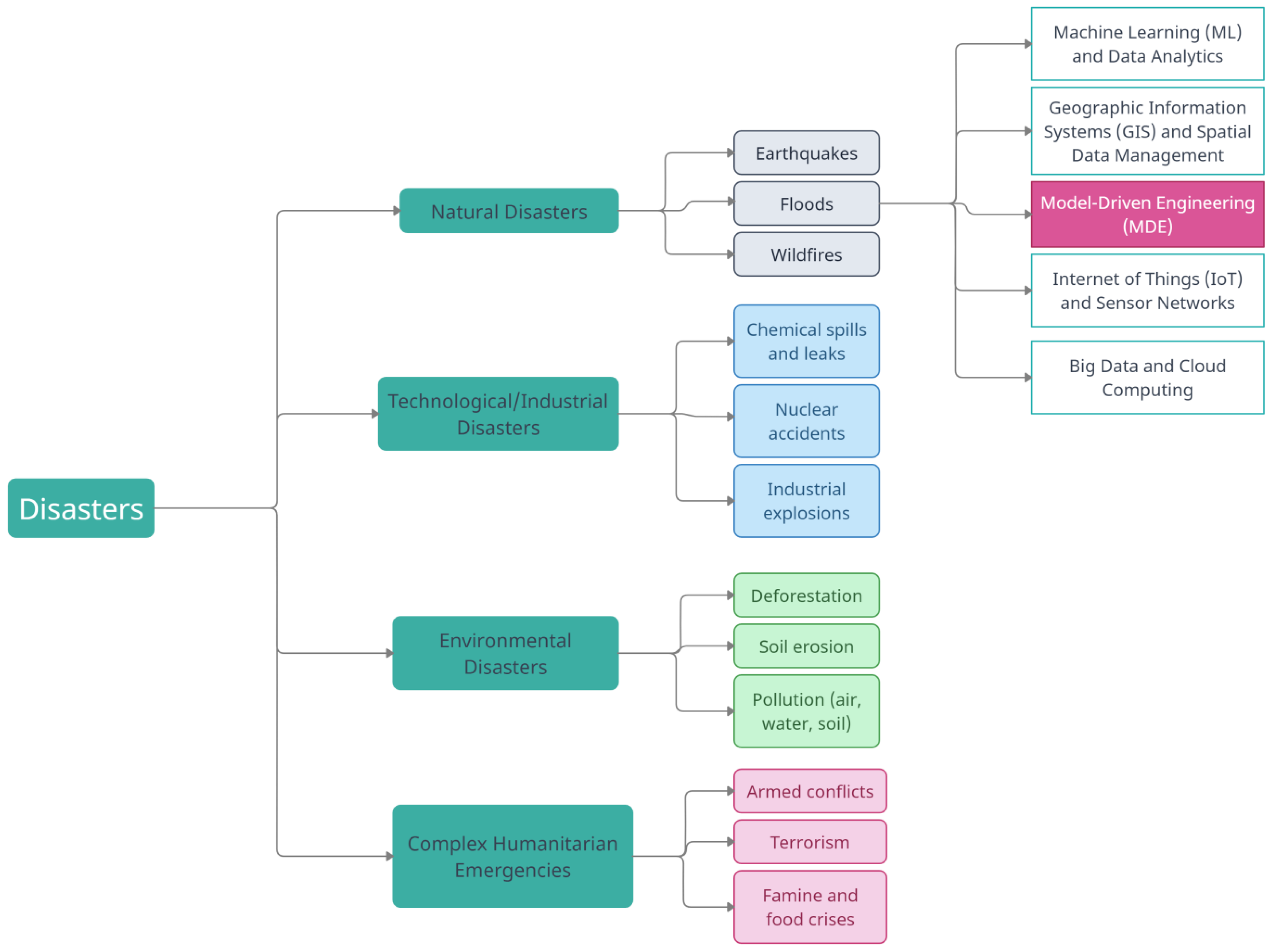
:1. Introduction
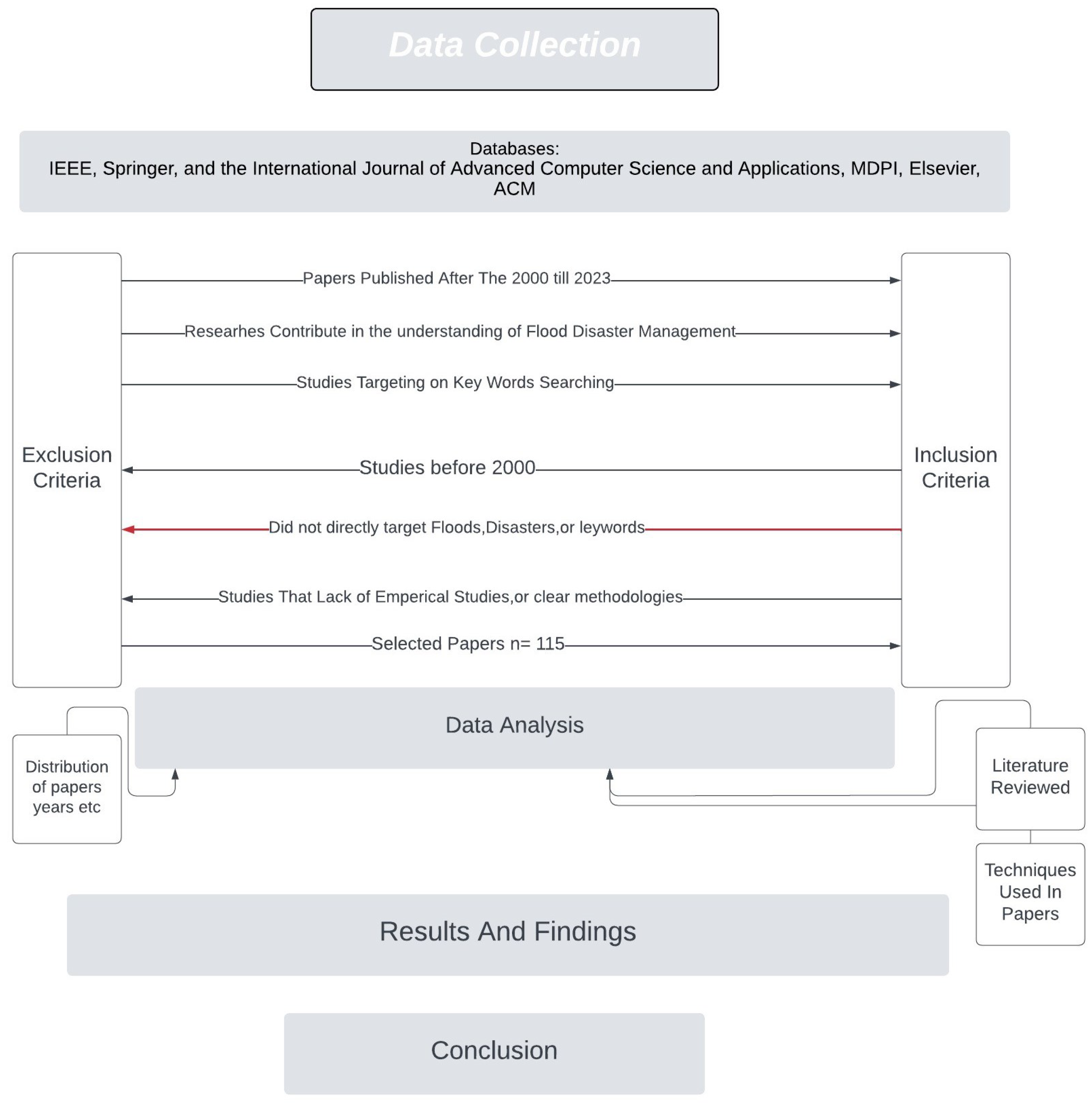
2. Research Methodology
3. Earthquake
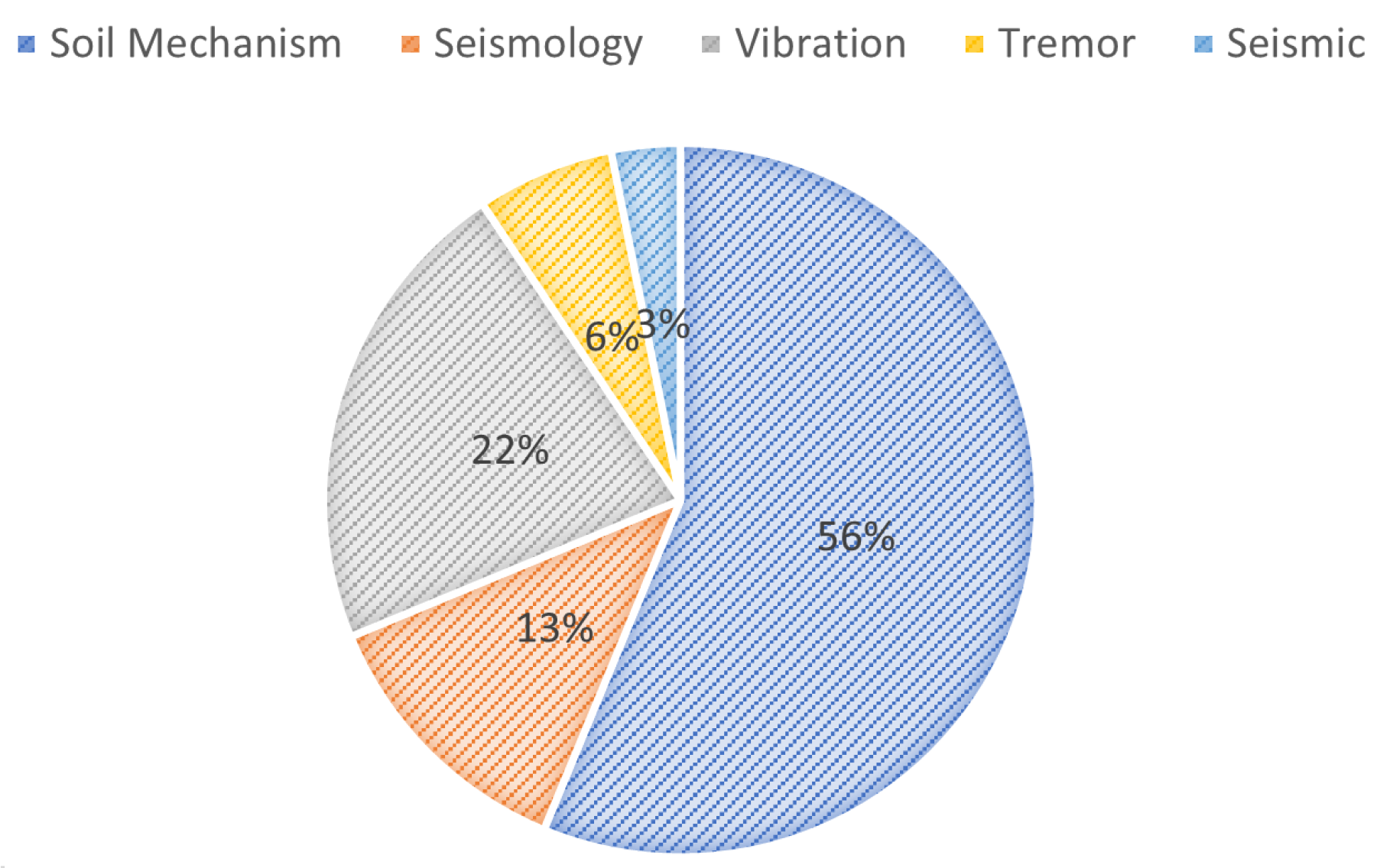
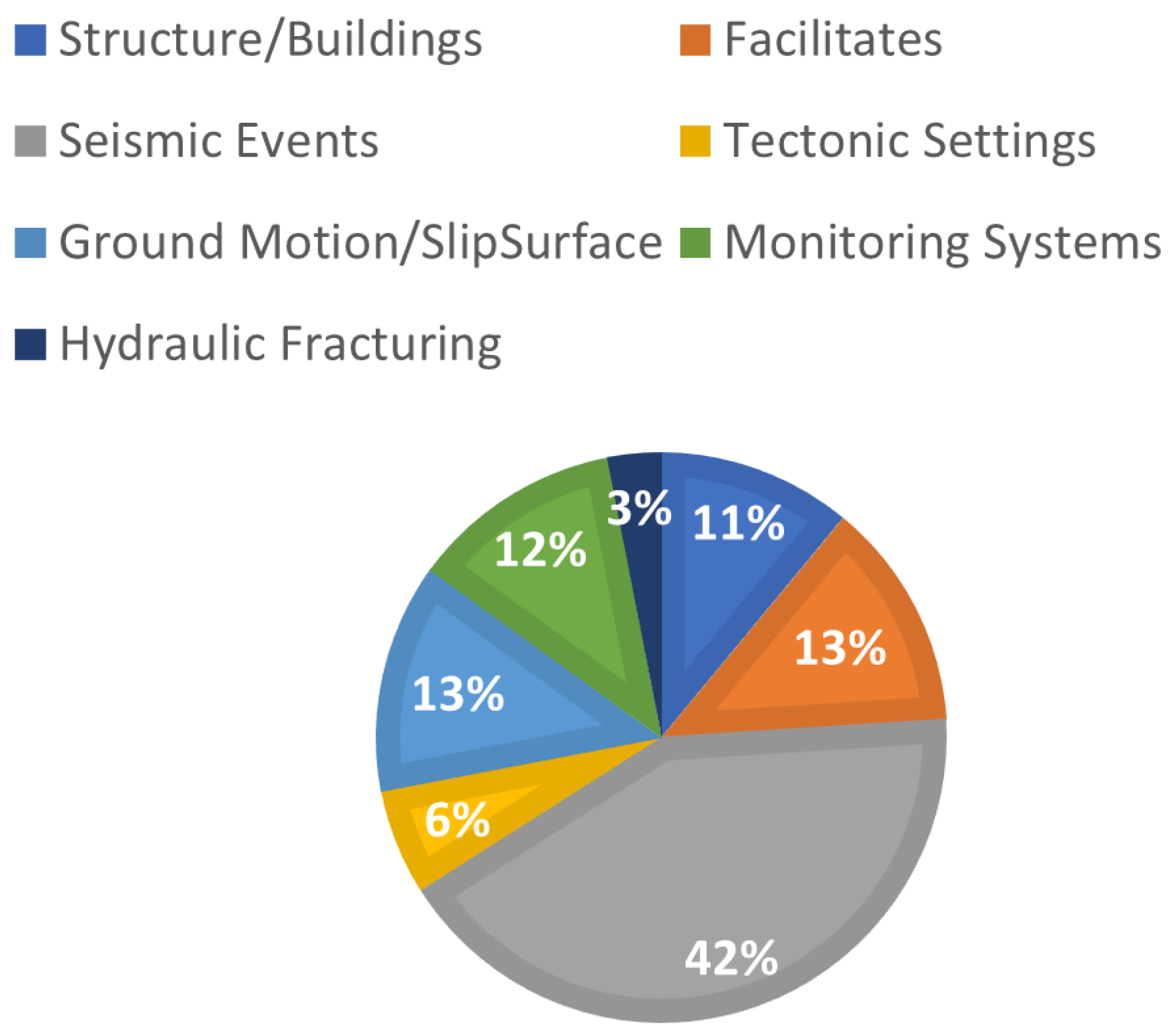
3.1. Analysis of Earthquake Keywords
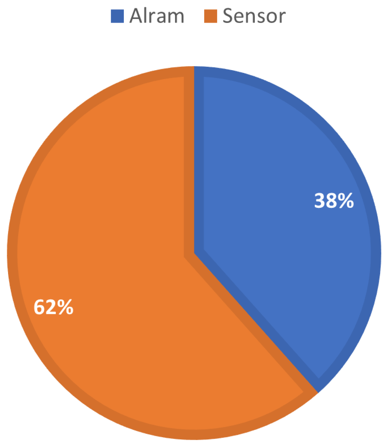
3.2. Analysis of Detector Keywords
3.3. Findings on Different Earthquake Detectors
3.4. Analysis of Earthquake Effects on the Environment
4. Wildfires
5. Floods
5.1. Data Analytics and Machine Learning for Floods
5.2. Geographical Information System and Spatial Data Management
5.3. Model-Driven Engineering
5.4. Sensors Network and Internet of Things
5.5. Big Data Analysis and Cloud Computing
5.6. Google Earth Engine
6. Applications Based on Remote Sensing for Disasters
6.1. Wildfires
6.2. Earthquakes
6.3. Floods
6.4. Interconnections between Techniques
6.5. Impacts of Disaster Management System on Human Beings
- Loss of Life and Injury: Technical problems in crisis management systems can slow down response and rescue efforts. This may cause delays in reaching affected areas, resulting in a larger number of casualties and injuries.
- Psychological Distress: When emergency management systems do not work well, people may feel alone and overwhelmed. This can make them feel more stressed, anxious, and traumatized.
- Disruption of Social Networks: When a disaster strikes, people often band together to help each other. Technical problems with crisis management systems can make it hard for people and communities to talk to each other and coordinate their relief efforts.
- Loss of Culture: Sometimes, disasters can damage or destroy culturally important locations and artifacts. Technical problems could make it harder to maintain and protect these important parts of cultural identity.
- Economic Loss: Technical flaws can stymie disaster response and recovery efforts, resulting in protracted downtime for businesses and key infrastructure. People, companies, and governments may lose money because of such disruptions.
- Inequality and Vulnerability: Vulnerable individuals, such as the elderly, disabled, or disadvantaged communities, may experience additional difficulties obtaining resources during catastrophes. Technical problems can make these differences worse, placing groups even more at risk.
- Migration and Displacement: If emergency management systems do not provide people with the right information or help, they may have to move or be moved in order to obtain help and resources.
- Lack of Information: During disasters, timely and accurate information is critical. Technical problems with communication systems can cause people to receive the wrong information, resulting in confusion and fear.
- Interconnected Disasters: In complex disasters with multiple events, technical problems can make it hard to obtain a full picture of events, in turn making it difficult to coordinate reactions.
- Loss of Trust in Institutions: Persistent technological failures in disaster management systems can erode public trust in government agencies and other institutions responsible for disaster response and management.
- Long-Term Recovery Challenges: It might be difficult to plan for effective recovery and mitigation plans when technical issues that hamper data collection and analysis make it impossible to estimate the long-term effects of catastrophes.
7. Challenges and Future Directions
7.1. General Challenges
- Effectively allocating limited resources such as personnel, equipment, and funding poses a challenge in disaster management, especially during simultaneous or resource-scarce events.
- Ensuring effective communication and coordination among stakeholders is needed to overcome issues such as complex networks, language barriers, and coordination problems between agencies and organizations.
- Gathering, analyzing, and disseminating timely and accurate information can be challenging during rapidly evolving disasters due to obstacles such as limited data, misinformation, and communication breakdowns.
- Engaging local communities and promoting their resilience presents challenges due to cultural differences, distrust, limited awareness, and resource constraints.
- It is necessary to adapt disaster management systems to cope with the changing characteristics and impacts of disasters, including climate change and urbanization.
- Overcoming challenges in collaboration across disciplines such as emergency management, engineering, social sciences, and public health, which have differing terminologies, approaches, and priorities, can be difficult.
- Ensuring sustainable and equitable recovery, addressing vulnerabilities, and integrating disaster risk reduction into development planning pose challenges beyond the immediate response phase.
7.2. Challenges Related to Floods
- The need for constant improvement in domains related to floods (model-driven, machine learning, GIS, etc.) to enhance the speed and interpretability of flood-related models.
- Lack of information on the computational time associated with flood modeling, hindering the evaluation of model applicability in disaster management.
- Limited development of feature selection techniques needed to increase the efficiency of decision support in flood management.
- Scarcity of studies comparing the computational efficiency of different simulation platforms for flood management.
7.3. Challenges Related to Earthquakes
- Insufficient exploration of global models that can be applied to different regions and datasets in earthquake prediction along with limited assessment of their potential for generalization.
- Limited integration of earthquake protection concerns in multi-functional landscape management planning considering multiple ecosystem services.
- Inadequate analysis of the minimum amount of data required for useful earthquake modeling, particularly during the active disaster stage.
- Challenges in dealing with uncertainties in earthquake forecasting models and their impact on management decisions.
7.4. Wildfire Challenges
- Lack of extensive wildfire datasets for training models; most models are developed using smaller wildfire events, and may not adequately represent extreme wildfire contexts.
- Need for advances in acquiring landscape dynamics data to quantify spatial patterns and changes in wildfire management.
- Addressing issues of model overfitting in wildfire prediction and management.
- Bridging the gaps between monitoring, learning, and decision-making in wildfire management.
- Developing broader models that can integrate different stages of wildfire management effectively.
7.5. Limitations and Challenges in Using Remote Sensing for Disaster Management
- Finding the most applicable remote sensing system for a given type of disasters.
- The need to evaluate the nature of the disaster and select appropriate sensors while considering spectral and temporal resolution as well as cloud coverage limitations; notably, the synergistic approach suggested by Joyce et al. [23] and Leblon et al. [55], involves combining visible sensors with microwave sensors to overcome cloud coverage effects.
- Available frameworks for using remote sensing in disaster management are limited [23]; moreover, there is a need to develop new frameworks or templates for applications in remote sensing for disaster management without “reinventing the wheel”.
- Challenges around timely provision of data mean that developing countries in particularly face limited access to certain data (e.g., high-resolution images) and may lack the technical expertise to handle it.
- Lack of research funding for application of remote sensing data in hazard management contexts limits the effective use of satellite data [21].
7.6. Future Directions
8. Conclusions
Funding
Data Availability Statement
Conflicts of Interest
Appendix A

| Ref. | Key Aspects | Conclusions with Specific Work | Validation/Results | Technique |
|---|---|---|---|---|
| [66] | Based on past data, create a monthly fire spread probability model. | Historical data and the likelihood of fire spread are significantly correlated. | Historical data | GIS |
| [67] | Analysis of wildfire exposure and risk transfer in Sardinia using wildfire simulation modeling | The major conclusions can be applied to further assess the likelihood of transmission or anticipated wildfire behavior. | Historical data | GIS |
| [68] | Introduction of Fire Map, a web platform for geospatial data services and fire prediction, including its architecture and main components. | Fire map has proven valuable in the firefighting community, providing automatic fire perimeter detection and reliable future forecasts. | - | GIS |
| [69] | Presentation of a methodology that combines automated wildfire monitoring with accurate fire spread forecasting. | The backward time method is a simple and effective approach for solving fire prediction. | Experiments | GIS |
| [70] | Proposal of various algorithms for fire behavior analysis using the final perimeter as input. | The developed tool is efficient and fully functional. | - | GIS |
| [71] | Discussion on integrating two models into a GIS-based interface | The tool developed is efficient and fully operational. | Historical data | GIS |
| [72] | Introduction of a model that evaluates the impact of five landscape factors on fire spread performance. | Categorizing fires based on synoptic weather conditions can enhance fire modeling in landscape fire models. | Historical data | GIS |
| [73] | Exploration of multi-fidelity approaches to fire spread prediction. | Fuel moisture, fuel load, and wind speed are the main uncertainties affecting fire spread rates. | Experiments | CFD |
| [74] | Investigation of how fuel density and heterogeneity affect fire behavior in relation to wind characteristics. | Increasing canopy fuel structure detail and implementing turbulent boundary conditions have minimal impact | Experiments | CFD |
| [75] | How fuel density and heterogeneity affect fire behavior in relation to wind characteristics. | Incorporating high-resolution fuel fidelity and heterogeneity information is crucial to capture effective wind conditions. | - | CFD |
| [76] | Considers the effect of vegetation characteristics on the flame tilt angle and the radiative heat transfer. | High-resolution fuel fidelity and heterogeneity information are vital for accurately capturing wind conditions. | Simulations | CFD |
| [77] | Investigate fire regime transition and its associated heat transfer mechanisms. | The model predicts both free and non-free fires, introducing new models for tilt angle and radiative heat power reaching vegetation. | Simulations | CFD |
| [78] | a fresh simulation tool for quick resolution, atmosphere fire reaction. | The ability to record fundamental patterns in fire behavior, the relationship between fire spread and fire size, and the use of canopy fuels. | Compared With other models | CFD |
| [79] | The multiphase model is created and added to PHOENICS. | The anticipated ROS and experimental values measured at varied wind speeds were in good agreement. | Experiments | CFD |
| [80] | Outlines a method for creating a burned area probabilistic forecast | The calibrated ensembles improve accuracy overall. | Simulations | Mathematical |
| [81] | Creation of a computer model to forecast soil organic matter loss | The amount of water in the soil regulated the amount of heat used during vaporization and stopped soil deterioration. | Simulations | Mathematical |
| [82] | Creating a fire spread model using a heterogeneous cellular automata model. | The model can anticipate the spread of a fire with a respectable level of accuracy and efficiency. | Simulations | Mathematical |
| [83] | Prediction of the spread of a surface fire with an emphasis on uncertainty. | Based on probabilistic fire simulations, maps of the potential for fire can be created. | Simulations | Mathematical |
| [84] | In an upslope fire spread model, parametric uncertainty analysis is developed. | The projected values of ROS under lower slopes are significantly impacted by the values of ignition and flame temperatures. | Simulations | Mathematical |
| [85] | Creation of two empirical ROS functions in a windless environment. | Both models demonstrate that independent variables serve as suitable ROS descriptors. | Simulations | Mathematical |
| [86] | Creation of an empirical model for ROS assisted by wind. | A laboratory examination of the Rothaermel model revealed improved predictions. | Simulations | Mathematical |
| [87] | Support Vector Machines, K-Nearest Neighbors, Random Forest, and Extreme Gradient Boosting. | Improvement techniques for the Fuel Management Zone | F1 scores between 90.0% and 94.0%, and a Kappa between 0.80 and 0.89. | Machine Learning |
| [88] | Gradient boosted regression, multiple linear regression, random forests, and neural networks | Determining fuel moisture content | Errors between 25.0–33.0% | Machine Learning |
| [89] | Support Vector Machine, Random Forest, and Multiple Linear Regression | Calculating the fine dead fuel load and comprehending the factors that affect it | (Random Forest, RMSE 0.09, MSE 0.01, r 0.71, R-2 0.50) | Machine Learning |
| [90] | Support vector machines and random forests | Estimating fuel moisture content for 10 h | R is between 0.77 and 0.82, while the RMSE ranges between 2.0 and 2.8%. | Machine Learning |
| [91] | Mask-Based Convolutional Neural Network | Network-based Dead Tree Detection from Aerial Images | 54.0% is the mean average precision score. | Machine Learning |
| [92] | Neural Network | Identification of flammable liquids on actual fire debris | 0.07 percent false positives and 0.59 percent real positives | Machine Learning |
| [93] | Support Vector Machines with Radial and Linear Kernels, K-Nearest Neighbors, and Linear and Quadratic Discriminant Analysis | Finding flammable liquid residue on fire debris | Equal error rates (17.0–22.0%), area under the receiver operating characteristic curve (0.86–0.92) | Machine Learning |
| [94] | Classification Trees, Random Forests, Neural Networks, Logistic Regression Models, and Logistic Generalized Additive Models are a few examples of the types of models. | Methods for fine-scale, spatially explicit daily fire occurrence prediction using statistical and machine learning models that have been correctly calibrated | - | Machine Learning |
| Ref. | Key Aspects | Conclusions | Validation/Res | Technique |
|---|---|---|---|---|
| [95] |
|
| N/A | Machine learning, DTM, known flooded locations |
| [96] |
|
| N/A | Fiber molding technology, load calculations, stability checks |
| [97] |
|
| Monte Carlo simulation | Decision-making model, game theory, stratification, interactive web application, Monte Carlo simulation |
| [98] |
|
| N/A | GIS tools, multi-source data, transdisciplinary models, and model-driven decision support systems |
| [99] |
|
| N/A | Review Paper |
| [100] |
|
| N/A | Disaster Management metamodel, DM decision support system |
| [101] |
|
| Achieved 88% accuracy for flooded buildings and 85% accuracy for vegetation | Deep learning models, UAV imag |
| [102] |
|
| Not mentioned | Literature review, analysis of challenges, identification of areas for improvement |
| [103] |
|
| Not mentioned | Real-time visualization and animation, parallel computing, selective visualization, georeferenced data usage |
| [104] |
|
| Not mentioned | Agent-based Modeling, development of FDMACS |
| [105] |
|
| Results demonstrate the improved performance of the adapted Sentinel-1 algorithm | Validation criteria, development of flood inundation time series, combination and cross-referencing of data sources |
| [106] |
| - | - | - |
| [107] | Importance of flood prediction and prevention systems, technologies for flood prediction and prevention, drawbacks of existing systems, proposed flood alert system | Existing flood alert systems have limitations, proposed model is protective and reliable, economical in terms of cost, assures self-defense from flash floods | Not specified in the given text | Grid-based monitoring, Warning based on User mobility, Early flood warning, Flood alarming, ShonaBondhu, Zigbee technology |
| [108] | Application of semantic computing models in IoT early warning systems, benefits, and challenges, proposed IoT EWS system framework | Semantic EWSs offer easier integration, improved analysis, and service interoperability, challenges include data exchange, heterogeneous data sources, and resource constraints | Validation through system-related metrics and a case study | Lightweight and heavyweight semantics, metadata-driven data analysis, semantic decision support, workflow orchestration |
| [109] | Using case-based reasoning in a multi-agent intelligent system, flood disaster forecasting | Proposed framework accurately predicts water levels and forecasts flood disasters with a lower error rate compared to neuro-fuzzy network-based method | Validation using “Active Archive of Large Floods, 1985-Present” dataset | Case-based reasoning, multiple agents, flood disaster forecasting algorithm |
| [110] | Risk-based flood management, flood management measures and approaches, risk assessment | Risk-based approaches gaining prominence globally, need for understanding risk dynamics and key parameters, consideration of socio-economic and environmental constraints | Not specified in the given text | Risk-based flood management, risk parameters, floodplain characteristics analysis |
| [111] | Implementation of a Smart IoT Flood Monitoring System using IoT technology | Proposed system enables real-time monitoring of water levels, remote access, and prediction capabilities, enhances public awareness, preparedness, and resilience | Not specified in the given text | Smart IoT Flood Monitoring System, IoT technology, web servers, wireless control |
| [112] | Emergency fleet management for preventing urban flooding, dependable fleet management approach | Data-driven resilient fleet management platform, dynamic management mechanism, and dispatching algorithm improve emergency fleet management resilience | Not specified in the given text | Optimization techniques, data-driven robust fleet management, cloud asset-enabled systems, and greedy-based dispatching algorithms |
| [113] |
|
|
| Long-Short-Term Memory (LSTM), Convolutional Neural Network (CNN), and ConvLSTM model |
| [6] |
|
|
| Sensor-based monitoring systems, data analysis, decision support dashboard |
| [114] |
|
|
| Satellite data, Integrated Disaster Reduction and Quick Service Platform, and remote sensing |
| [115] |
|
|
| Multiplicative seasonal ARIMA (SARIMA) |
| [116] | Importance of response phase in Disaster Management System life cycle. |
| N/A | Spatial DBMS, spatial schema, indexing techniques, operations |
| [117] |
|
| Successful prediction of previous floods with 84% accuracy. | Federated learning, local models, flood forecasting, feed-forward neural network |
| [118] |
|
| Correct percentage: 97.93, Kappa coefficient: 0.89, MAE: 0.01, RMSE: 0.10. | Decision trees, Naive Bayes, MLP ANN, Random Forest (RF), Support Vector Machines (SVM), fuzzy logic, meteorological data, hydrological data, geospatial data, crowdsource data |
| [119] |
|
| Ongoing evaluation required. | Regional data, climate scenarios, flood risk management planning |
| [120] |
|
|
|
|
| [121] |
|
| Criteria validated through comparative analysis | Criteria for evaluating the incorporation of geospatial data in DRM |
| [122] |
|
|
| Literature review - Recommendations for improving integration |
| [123] |
|
| IoT-enabled disaster management systems’ current research directions and open problems | Literature review - State-of-the-art scenarios - Open challenges and research trends |
| [124] |
|
|
|
|
| [125] |
|
|
|
|
| [126] |
|
|
| radar, sensor fusion, or artificial intelligence |
| [127] |
|
|
|
|
| [128] |
|
| N/A |
|
| [129] |
|
| N/A |
|
| [130] |
|
|
|
|
| [131] |
|
|
|
|
| [132] |
|
|
|
|
| [133] |
|
|
|
|
| [134] |
|
|
|
|
| [135] |
|
|
|
|
| [136] |
|
|
|
|
| [137] |
|
|
|
|
| [138] |
|
|
|
|
| Ref. | Interconnection and Synergies |
|---|---|
| [66] | Historical Data and Fire Maps for Fire Spread Prediction; Enhancing Fire Prediction Models; Factors Influencing Fire Behavior |
| [67] | Enhancing Fire Prediction Models; Calibration and Ensemble Methods for Improved Predictions |
| [68] | Historical Data and Fire Maps for Fire Spread Prediction; Enhancing Fire Prediction Models; Efficient Tools for Fire Detection and Spread Prediction |
| [69] | Factors Influencing Fire Behavior; Calibration and Ensemble Methods for Improved Predictions |
| [70] | Efficient Tools for Fire Detection and Spread Prediction; Efficient Tools for Non-Free Fires and Radiative Heat Power |
| [71] | Enhancing Fire Prediction Models; Efficient Tools for Fire Detection and Spread Prediction |
| [72] | Historical Data and Fire Maps for Fire Spread Prediction; Factors Influencing Fire Behavior |
| [73] | Enhancing Fire Prediction Models; Factors Influencing Fire Behavior; Importance of High-Resolution Fuel Information |
| [74] | Efficient Tools for Fire Detection and Spread Prediction; Importance of High-Resolution Fuel Information |
| [75] | Importance of High-Resolution Fuel Information |
| [76] | Enhancing Fire Prediction Models; Factors Influencing Fire Behavior; Importance of High-Resolution Fuel Information |
| [77] | Enhancing Fire Prediction Models; Efficient Tools for Fire Detection and Spread Prediction; Efficient Tools for Non-Free Fires and Radiative Heat Power |
| [78] | Factors Influencing Fire Behavior; Statistical and Machine Learning Models for Fire Occurrence Prediction |
| [79] | Enhancing Fire Prediction Models; Calibration and Ensemble Methods for Improved Predictions; Factors Influencing Fire Behavior; Statistical and Machine Learning Models for Fire Occurrence Prediction |
| [80] | Enhancing Fire Prediction Models; Efficient Tools for Fire Detection and Spread Prediction; Factors Influencing Fire Behavior; Calibration and Ensemble Methods for Improved Predictions |
| [81] | Efficient Tools for Fire Detection and Spread Prediction; Techniques for Detecting Flammable Substances |
| [82] | Enhancing Fire Prediction Models; Efficient Tools for Fire Detection and Spread Prediction; Calibration and Ensemble Methods for Improved Predictions; Factors Influencing Fire Behavior |
| [83] | Historical Data and Fire Maps for Fire Spread Prediction; Enhancing Fire Prediction Models; Calibration and Ensemble Methods for Improved Predictions |
| [84] | Importance of High-Resolution Fuel Information; Statistical and Machine Learning Models for Fire Occurrence Prediction |
| [85] | Enhancing Fire Prediction Models; Efficient Tools for Fire Detection and Spread Prediction; Factors Influencing Fire Behavior; Efficient Tools for Non-Free Fires and Radiative Heat Power |
| [86] | Enhancing Fire Prediction Models; Techniques for Estimating Fuel Moisture Content and Load |
| [87] | Statistical and Machine Learning Models for Fire Occurrence Prediction; Techniques for Estimating Fuel Moisture Content and Load |
| [88] | Enhancing Fire Prediction Models; Importance of High-Resolution Fuel Information |
| [89] | Enhancing Fire Prediction Models; Importance of High-Resolution Fuel Information; Techniques for Estimating Fuel Moisture Content and Load |
| [90] | Techniques for Estimating Fuel Moisture Content and Load |
| [91] | Techniques for Detecting Flammable Substances |
| [92] | Efficient Tools for Fire Detection and Spread Prediction; Techniques for Detecting Flammable Substances |
| [93] | Factors Influencing Fire Behavior |
| [94] | Enhancing Fire Prediction Models; Statistical and Machine Learning Models for Fire Occurrence Prediction |
| Ref. | Interconnection and Synergies |
|---|---|
| [95] | Machine Learning and Flood Risk Mapping |
| [96] | Machine Learning and Flood Risk Mapping |
| [97] | Amphibious Construction Strategies for Flood-Resilient Housing |
| [98] | Decision-Making Models for Flood Risk Management |
| [99] | Model-Driven Decision Support Systems (MDSS) |
| [100] | Flood Disaster Management in Malaysia |
| [101] | Disaster Management Metamodel; UAV-based Flood Detection; Agent-based Modeling for Flood Risk Assessment; Storm Surge Visualization and Animation |
| [102] | Disaster Management Metamodel; Semantic Computing in IoT Early Warning Systems; Agent-Based Flood Disaster Forecasting |
| [103] | IoT-based Disaster Management Challenges |
| [104] | Storm Surge Visualization and Animation; Data-Driven Resilient Fleet Management; Flood Risk Assessment and Prediction |
| [105] | Agent-based Modeling for Flood Risk Assessment |
| [106] | Remote Sensing for Flood Index Insurance; Flood Prediction and Prevention Systems |
| [107] | Model-Based Systems Engineering (MBSE) for Disaster Management Systems |
| [108] | Remote Sensing for Flood Index Insurance; Flood Prediction and Prevention Systems |
| [109] | Semantic Computing in IoT Early Warning Systems; Smart IoT Flood Monitoring System |
| [110] | Model-Based Systems Engineering (MBSE) for Disaster Management Systems; Agent-Based Flood Disaster Forecasting |
| [111] | Risk-Based Flood Management; ConvLSTM-based Flood Forecasting Model; Comprehensive Flood Management System in Jakarta |
| [112] | Smart IoT Flood Monitoring System; Data-Driven Resilient Fleet Management; Risk-Based Flood Management; ConvLSTM-based Flood Forecasting Model |
| [113] | Data-Driven Resilient Fleet Management |
| [6] | Risk-Based Flood Management; Smart IoT Flood Monitoring System; ConvLSTM-based Flood Forecasting Model; Flood Risk Assessment and Prediction |
| [114] | Risk-Based Flood Management; ConvLSTM-based Flood Forecasting Model; Comprehensive Flood Management System in Jakarta |
| [115] | Disaster Management System in China; Flood Prediction Models |
| [116] | Semantic Computing in IoT Early Warning Systems; Flood Prediction Models; GIS and Spatial Data Management; Data Privacy and Security |
| [117] | GIS and Spatial Data Management; Data Privacy and Security |
| [118] | Disaster Management System in China; Flood Prediction Models; GIS and Spatial Data Management; Data Privacy and Security |
| [119] | Disaster Management System in China; Flood Prediction Models; GIS and Spatial Data Management; Data Privacy and Security; Utilization of Geospatial Data; Communication and Collaboration |
| [120] | Data Privacy and Security; Utilization of Geospatial Data; Communication and Collaboration |
| [121] | Data Privacy and Security; Utilization of Geospatial Data; Communication and Collaboration |
| [122] | Utilization of Geospatial Data; Communication and Collaboration |
| [123] | Data Privacy and Security; Utilization of Geospatial Data; Communication and Collaboration |
| [124] | Future Research and Improvements; Flood Risk Assessment and Prediction |
| [125] | Integrated Decision Support Systems (DSS); Data Acquisition and Processing; Use of Artificial Intelligence; Focus on Specific Regions; Data Sharing and Interoperability; Integration of Advanced Technologies |
| [126] | Integrated Decision Support Systems (DSS); Data Acquisition and Processing |
| [127] | Use of Artificial Intelligence; Focus on Specific Regions |
| [128] | Data Acquisition and Processing |
| [129] | Technology Integration, Use of Artificial Intelligence, Focus on Specific Regions |
| [130] | Future Research and Improvements, Integration of Advanced Technologies, Real-Time Information and Decision-Making |
| [131] | Future Research and Improvements, Integration of Advanced Technologies, Real-Time Information and Decision-Making |
| [132] | Integration of Advanced Technologies |
| [133] | Integration of Advanced Technologies, Real-Time Information and Decision-Making |
| [134] | Assessment of droughts and floods impact on croplands and crop production in Southeast Asia, Google Earth Engine. |
| [135] | Development of an algorithm to map surface inundation during flood events, GEE. |
| [136] | Examination of spatiotemporal flood patterns in Bangladesh, GEE. |
| [137] | GEE, Algorithm to generate reliable inundation maps using different polarization combinations. |
| [138] | Google Earth Engine, Development and application of the Flood Prevention and Emergency Response System (FPERS) |
References
- Okada, T.; Larcombe, P.; Mason, C. Estimating the spatial distribution of dredged material disposed of at sea using particle-size distributions and metal concentrations. Mar. Pollut. Bull. 2009, 58, 1164–1177. [Google Scholar] [CrossRef] [PubMed]
- Othman, S.H.; Beydoun, G. A metamodel-based knowledge sharing system for disaster management. Expert Syst. Appl. 2016, 63, 49–65. [Google Scholar] [CrossRef] [Green Version]
- Recker, J. “Modeling with tools is easier, believe me”—The effects of tool functionality on modeling grammar usage beliefs. Inf. Syst. 2012, 37, 213–226. [Google Scholar] [CrossRef] [Green Version]
- Yahya, H.; Latif, A.A.; Ahmad, M.N. A preliminary study of the construction of ontology-based flood management systems. In Proceedings of the 2017 6th ICT International Student Project Conference (ICT-ISPC), Johor, Malaysia, 23–24 May 2017; pp. 1–4. [Google Scholar]
- Greenfield, J.; Short, K. Software factories: Assembling applications with patterns, models, frameworks and tools. In Proceedings of the Companion of the 18th annual ACM SIGPLAN Conference on Object-Oriented Programming, Systems, Languages, and Applications, Anaheim, CA, USA, 26–30 October 2003; pp. 16–27. [Google Scholar]
- Sulasikin, A.; Nugrahat, Y.; Aminanto, M.E.; Nasution, B.I.; Kanggrawan, J.I. Developing a knowledge management system for supporting flood decision-making. In Proceedings of the 2022 IEEE International Smart Cities Conference (ISC2), Pafos, Cyprus, 26–29 September 2022; pp. 1–4. [Google Scholar]
- Aini, M.; Fakhru’l-Razi, A.; Daud, M.; Adam, N.; Abdul Kadir, R. Analysis of royal inquiry report on the collapse of a building in Kuala Lumpur: Implications for developing countries. Disaster Prev. Manag. Int. J. 2005, 14, 55–79. [Google Scholar] [CrossRef]
- Flannigan, M.D.; Amiro, B.D.; Logan, K.A.; Stocks, B.J.; Wotton, B.M. Forest fires and climate change in the 21st century. Mitig. Adapt. Strateg. Glob. Chang. 2006, 11, 847–859. [Google Scholar] [CrossRef]
- Bowman, D.M.; Balch, J.; Artaxo, P.; Bond, W.J.; Cochrane, M.A.; D’antonio, C.M.; DeFries, R.; Johnston, F.H.; Keeley, J.E.; Krawchuk, M.A.; et al. The human dimension of fire regimes on Earth. J. Biogeogr. 2011, 38, 2223–2236. [Google Scholar] [CrossRef] [Green Version]
- Filkov, A.I.; Ngo, T.; Matthews, S.; Telfer, S.; Penman, T.D. Impact of Australia’s catastrophic 2019/20 bushfire season on communities and environment. Retrospective analysis and current trends. J. Saf. Sci. Resil. 2020, 1, 44–56. [Google Scholar] [CrossRef]
- Richards, L.; Brew, N.; Smith, L. 20 Australian bushfires—Frequently asked questions: A quick guide. Res. Pap. Ser. 2019, 2020. [Google Scholar]
- British Broadcasting Company. Australian Fires: Why Do People Start Fires during Fires? 2019. Available online: https://www.bbc.com/news/world-australia-50400851 (accessed on 14 September 2022).
- Williams, A.P.; Abatzoglou, J.T.; Gershunov, A.; Guzman-Morales, J.; Bishop, D.A.; Balch, J.K.; Lettenmaier, D.P. Observed impacts of anthropogenic climate change on wildfire in California. Earth’s Future 2019, 7, 892–910. [Google Scholar] [CrossRef] [Green Version]
- Ribeiro, L.M.; Viegas, D.X.; Almeida, M.; McGee, T.K.; Pereira, M.G.; Parente, J.; Xanthopoulos, G.; Leone, V.; Delogu, G.M.; Hardin, H. Extreme wildfires and disasters around the world: Lessons to be learned. In Extreme Wildfire Events and Disasters; Elsevier: Amsterdam, The Netherlands, 2020; pp. 31–51. [Google Scholar]
- Naeher, L.P.; Brauer, M.; Lipsett, M.; Zelikoff, J.T.; Simpson, C.D.; Koenig, J.Q.; Smith, K.R. Woodsmoke health effects: A review. Inhal. Toxicol. 2007, 19, 67–106. [Google Scholar] [CrossRef]
- Walter, C.M.; Schneider-Futschik, E.K.; Knibbs, L.D.; Irving, L.B. Health impacts of bushfire smoke exposure in Australia. Respirology 2020, 25, 495–501. [Google Scholar] [CrossRef]
- Becker, J.S.; Paton, D.; Johnston, D.M.; Ronan, K.R. A model of household preparedness for earthquakes: How individuals make meaning of earthquake information and how this influences preparedness. Nat. Hazards 2012, 64, 107–137. [Google Scholar] [CrossRef]
- Balendra, T.; Li, Z. Seismic hazard of Singapore and Malaysia. Electron. J. Struct. Eng. 2008, 57–63. [Google Scholar] [CrossRef]
- Lee, W.H.; Espinosa-Aranda, J.M. Earthquake early warning systems: Current status and perspectives. In Early Warning Systems for Natural Disaster Reduction; Springer: Berlin/Heidelberg, Germany, 2003; pp. 409–423. [Google Scholar]
- Verstappen, H.T. Environmental hazards and the use of satellite remote sensing for sustainable development. In Geo-Informalion Technology Applications for Resource & Environmental Management in Africa, AARSE; African Association of Remote Sensing of the Environment, Univeristy of Lagos: Lagos, Nigeria, 1999. [Google Scholar]
- Van Westen, C. Remote sensing and geographic information systems for natural disaster management. Environ. Model. GIS Remote Sens. 2002, 6, 200–222. [Google Scholar]
- Li, B.; Liu, J. Application of remote sensing technique for disaster management. In Proceedings of the 2006 IEEE International Symposium on Geoscience and Remote Sensing, Denver, CO, USA, 31 July 2006–4 August 2006; pp. 283–286. [Google Scholar]
- Joyce, K.E.; Belliss, S.E.; Samsonov, S.V.; McNeill, S.J.; Glassey, P.J. A review of the status of satellite remote sensing and image processing techniques for mapping natural hazards and disasters. Prog. Phys. Geogr. 2009, 33, 183–207. [Google Scholar] [CrossRef] [Green Version]
- Joyce, K.E.; Wright, K.C.; Samsonov, S.V.; Ambrosia, V.G. Remote sensing and the disaster management cycle. Adv. Geosci. Remote Sens. 2009, 48, 317–346. [Google Scholar]
- Quarantelli, E.L. Ten criteria for evaluating the management of community disasters. Disasters 1997, 21, 39–56. [Google Scholar] [CrossRef] [Green Version]
- Li, X.; Rowley, R.J.; Kostelnick, J.C.; Braaten, D.; Meisel, J.; Hulbutta, K. GIS analysis of global impacts from sea level rise. Photogramm. Eng. Remote Sens. 2009, 75, 807–818. [Google Scholar] [CrossRef] [Green Version]
- Aleem, K.; Aina, Y. The use of SRTM in assessing the vulnerability to predicted sea level rise in Yanbu industrial city, Saudi Arabia. In Proceedings of the FIG Working Week, Abuja, Nigeria, 6–10 May 2013. [Google Scholar]
- Chakraborty, S.; Sasmal, S.; Basak, T.; Chakrabarti, S.K. Comparative study of charged particle precipitation from Van Allen radiation belts as observed by NOAA satellites during a land earthquake and an ocean earthquake. Adv. Space Res. 2019, 64, 719–732. [Google Scholar] [CrossRef]
- Akhoondzadeh, M. Decision Tree, Bagging and Random Forest methods detect TEC seismo-ionospheric anomalies around the time of the Chile, (Mw = 8.8) earthquake of 27 February 2010. Adv. Space Res. 2016, 57, 2464–2469. [Google Scholar] [CrossRef]
- Huayong, N.; Hua, G.; Yanchao, G.; Blumetti, A.M.; Comerci, V.; Di Manna, P.; Guerrieri, L.; Vittori, E. Comparison of Earthquake Environmental Effects and ESI intensities for recent seismic events in different tectonic settings: Sichuan (SW China) and Central Apennines (Italy). Eng. Geol. 2019, 258, 105149. [Google Scholar] [CrossRef]
- Chaudhary, B.; Hazarika, H.; Ishibashi, I.; Abdullah, A. Sliding and overturning stability of breakwater under combined effect of earthquake and tsunami. Ocean Eng. 2017, 136, 106–116. [Google Scholar] [CrossRef]
- Risnapati, P.N.; Wulaning, P.D.; Hendrawan, I.N.R.; Bandanagara, A.A.K.B. Earthquake damage intensity scaling system based on raspberry Pi and Arduino Uno. In Proceedings of the 2018 6th International Conference on Cyber and IT Service Management (CITSM), Parapat, Indonesia, 7–9 August 2018; pp. 1–4. [Google Scholar]
- Ahangar-Asr, A.; Toufigh, M.; Salajegheh, A. Determination of the most probable slip surface in 3D slopes considering the effect of earthquake force direction. Comput. Geosci. 2012, 45, 119–130. [Google Scholar] [CrossRef]
- Zhu, L.; Peng, Z.; McClellan, J.; Li, C.; Yao, D.; Li, Z.; Fang, L. Deep learning for seismic phase detection and picking in the aftershock zone of 2008 Mw7. 9 Wenchuan Earthquake. Phys. Earth Planet. Inter. 2019, 293, 106261. [Google Scholar] [CrossRef] [Green Version]
- Sevilla, W.I.; Jumawan, L.A.; Clarito, C.J.; Quintia, M.A.; Dominguiano, A.A.; Solidum, R.U., Jr. Improved 1D velocity model and deep long-period earthquakes in Kanlaon Volcano, Philippines: Implications for its magmatic system. J. Volcanol. Geotherm. Res. 2020, 393, 106793. [Google Scholar] [CrossRef]
- Nor, A.H.M.; Sanik, M.E.; Salim, S.; Kaamin, M.; Osman, M.H.; Fuzairi, N.; Alia, A.; Qurratu’Ain, N. A Systematic Literature Review on Earthquake Detector. Multidiscip. Appl. Res. Innov. 2021, 2, 48–59. [Google Scholar]
- Foti, D.; La Scala, M.; Lamonaca, S.; Vacca, V. An Energy Router for structural monitoring of framed buildings and real-time shutdown of power and gas supply during earthquakes. No. Febr. 2017, 13, 495–502. [Google Scholar]
- Aczel, M.; Makuch, K. Shale, quakes, and high stakes: Regulating fracking-induced deismicity in Oklahoma, USA and Lancashire, UK. Case Stud. Environ. 2019, 3, 1–14. [Google Scholar] [CrossRef]
- Zhang, Z.; Deng, Y.; Chen, L.; Wu, J.; Teng, J.; Panza, G. Seismic structure and rheology of the crust under mainland China. Gondwana Res. 2013, 23, 1455–1483. [Google Scholar] [CrossRef]
- Liu, X.; Li, Y. Experimental study of seismic behavior of partially corrosion-damaged reinforced concrete columns strengthened with FRP composites with large deformability. Constr. Build. Mater. 2018, 191, 1071–1081. [Google Scholar] [CrossRef]
- Cakir, T. Evaluation of the effect of earthquake frequency content on seismic behavior of cantilever retaining wall including soil–structure interaction. Soil Dyn. Earthq. Eng. 2013, 45, 96–111. [Google Scholar] [CrossRef]
- Cho, Z.M.; Hein, W.Z. Design and Construction of Earthquake Detection and Location Reporting System on Google Map. Int. J. Sci. Res. Eng. Dev. 2019, 2, 691–698. [Google Scholar]
- Huang, L.; Du, Y.; Zheng, J.; Zhang, Y. Detection of precursory wave using a novel sensor and its application to earthquake prediction. AASRI Procedia 2012, 3, 613–618. [Google Scholar] [CrossRef]
- Tomaneng, S.D.G.; Docdoc, J.A.P.; Hierl, S.A.; Cerna, P.D. Towards the Development a Cost-effective Earthquake Monitoring System and Vibration Detector with SMS Notification Using IOT. Int. J. Eng. Manuf. 2022, 12, 22. [Google Scholar] [CrossRef]
- Dutta, P.K. Earthquake alarm detector microcontroller based circuit for issuing warning for vibration in steel foundations. Int. J. Mechatron. Electr. Comput. Technol. 2017, 7, 3582–3594. [Google Scholar]
- Baser, B.; Behnam, B. An emergency response plan for cascading post-earthquake fires in fuel storage facilities. J. Loss Prev. Process Ind. 2020, 65, 104155. [Google Scholar] [CrossRef]
- Balucan, S.J.H.; Bonete, K.T.; Hadjisalic, R.A.; Nasroding, N.A.; Valenzuela, L.M.C.; Sagarino, C.T. AEGIS: A Prototype Arduino-Based Earthquake-Proof Container. 2016. [Google Scholar]
- Groover, V.; Sharma, A. Prediction of Earthquake Using 3 Axis Accelerometer Sensor (ADXL335) and ARDUINO UNO. Int. J. Sci. Res. (IJSR) 2015. Available online: https://www.ijsr.net/archive/v6i9/ART20176803.pdf (accessed on 21 March 2023).
- Pelliccia, R.A. Vibration Sensor and Electrical Power Shut off Device. U.S. Patent 4,390,922, 28 June 1983. [Google Scholar]
- Linn, R.R.; Cunningham, P. Numerical simulations of grass fires using a coupled atmosphere–fire model: Basic fire behavior and dependence on wind speed. J. Geophys. Res. Atmos. 2005, 110. [Google Scholar] [CrossRef]
- Lopes, A.; Cruz, M.G.; Viegas, D. FireStation—an integrated software system for the numerical simulation of fire spread on complex topography. Environ. Model. Softw. 2002, 17, 269–285. [Google Scholar] [CrossRef]
- Mochida, A.; Tabata, Y.; Iwata, T.; Yoshino, H. Examining tree canopy models for CFD prediction of wind environment at pedestrian level. J. Wind Eng. Ind. Aerodyn. 2008, 96, 1667–1677. [Google Scholar] [CrossRef]
- Mandel, J.; Beezley, J.D.; Kochanski, A.K. Coupled atmosphere-wildland fire modeling with WRF-Fire version 3.3. Geosci. Model Dev. Discuss. 2011, 4, 497–545. [Google Scholar]
- Ryan, K.C.; Opperman, T.S. LANDFIRE–A national vegetation/fuels data base for use in fuels treatment, restoration, and suppression planning. For. Ecol. Manag. 2013, 294, 208–216. [Google Scholar] [CrossRef] [Green Version]
- Leblon, B.; Bourgeau-Chavez, L.; San-Miguel-Ayanz, J. Use of remote sensing in wildfire management. In Sustainable Development-Authoritative and Leading Edge Content for Environmental Management; Books on Demand: Norderstedt, Germany, 2012; pp. 55–82. [Google Scholar]
- Chuvieco, E.; Congalton, R.G. Application of remote sensing and geographic information systems to forest fire hazard mapping. Remote Sens. Environ. 1989, 29, 147–159. [Google Scholar] [CrossRef]
- Isaev, A.; Korovin, G.; Bartalev, S.; Ershov, D.; Janetos, A.; Kasischke, E.; Shugart, H.; French, N.; Orlick, B.; Murphy, T. Using remote sensing to assess Russian forest fire carbon emissions. Clim. Chang. 2002, 55, 235–249. [Google Scholar] [CrossRef]
- Van Westen, K.; Soeters, R.; Buchroithner, M.F. Potential and limitations of satellite remote sensing for geo-disaster reduction. Int. Arch. Photogramm. Remote Sens. 1996, 6, 39–44. [Google Scholar]
- Tralli, D.M.; Blom, R.G.; Zlotnicki, V.; Donnellan, A.; Evans, D.L. Satellite remote sensing of earthquake, volcano, flood, landslide and coastal inundation hazards. ISPRS J. Photogramm. Remote Sens. 2005, 59, 185–198. [Google Scholar] [CrossRef]
- Parvaiz, I.; Champatiray, P.; Bhat, F.; Dadhwal, V. Earthquake-induced landslide dam in the Kashmir Himalayas. Int. J. Remote Sens. 2012, 33, 655–660. [Google Scholar] [CrossRef]
- van Aardt, J.A.; McKeown, D.; Faulring, J.; Raqueño, N.; Casterline, M.; Renschler, C.; Eguchi, R.; Messinger, D.; Krzaczek, R.; Cavillia, S.; et al. Geospatial disaster response during the Haiti earthquake: A case study spanning airborne deployment, data collection, transfer, processing, and dissemination. Photogramm. Eng. Remote Sens. 2011, 77, 943–952. [Google Scholar] [CrossRef] [Green Version]
- Withee, G.W.; Smith, D.B.; Hales, M.B. Progress in multilateral Earth observation cooperation: CEOS, IGOS and the ad hoc Group on Earth Observations. Space Policy 2004, 20, 37–43. [Google Scholar] [CrossRef]
- Barrett, E. The Storm Project: Using Remote Sensing for Improved Monitoring and Prediction of Heavy Rainfall and Related Events; Taylor & Francis: Abingdon, UK, 1996. [Google Scholar]
- Chakraborti, A. Satellite remote sensing for near-real-time flood and drought impact assessment-Indian experience. In Proceedings of the Workshop on Natural Disasters and Their Mitigation—A Remote Sensing & GIS Perspective, Dehradun, India, 11–15 October 1999; pp. 11–15. [Google Scholar]
- Kordzakhia, G.; Shengelia, L.; Tvauri, G.; Tatishvili, M.; Mkurnalidze, I. Remote sensing for early warning of natural meteorological and hydrological disasters and provision of transportation safety over the Black Sea in Georgia. Procedia-Soc. Behav. Sci. 2011, 19, 532–536. [Google Scholar] [CrossRef] [Green Version]
- Oliveira, U.; Soares-Filho, B.; de Souza Costa, W.L.; Gomes, L.; Bustamante, M.; Miranda, H. Modeling fuel loads dynamics and fire spread probability in the Brazilian Cerrado. For. Ecol. Manag. 2021, 482, 118889. [Google Scholar] [CrossRef]
- Salis, M.; Arca, B.; Del Giudice, L.; Palaiologou, P.; Alcasena-Urdiroz, F.; Ager, A.; Fiori, M.; Pellizzaro, G.; Scarpa, C.; Schirru, M.; et al. Application of simulation modeling for wildfire exposure and transmission assessment in Sardinia, Italy. Int. J. Disaster Risk Reduct. 2021, 58, 102189. [Google Scholar] [CrossRef]
- Crawl, D.; Block, J.; Lin, K.; Altintas, I. Firemap: A dynamic data-driven predictive wildfire modeling and visualization environment. Procedia Comput. Sci. 2017, 108, 2230–2239. [Google Scholar] [CrossRef]
- Valero, M.M.; Rios, O.; Mata, C.; Pastor, E.; Planas, E. An integrated approach for tactical monitoring and data-driven spread forecasting of wildfires. Fire Saf. J. 2017, 91, 835–844. [Google Scholar] [CrossRef]
- Monedero, S.; Ramírez, J.; Molina-Terrén, D.; Cardil, A. Simulating wildfires backwards in time from the final fire perimeter in point-functional fire models. Environ. Model. Softw. 2017, 92, 163–168. [Google Scholar] [CrossRef]
- Prieto Herráez, D.; Asensio Sevilla, M.I.; Ferragut Canals, L.; Cascón Barbero, J.M.; Morillo Rodríguez, A. A GIS-based fire spread simulator integrating a simplified physical wildland fire model and a wind field model. Int. J. Geogr. Inf. Sci. 2017, 31, 2142–2163. [Google Scholar] [CrossRef]
- Duane, A.; Aquilue, N.; Gil-Tena, A.; Brotons, L. Integrating fire spread patterns in fire modelling at landscape scale. Environ. Model. Softw. 2016, 86, 219–231. [Google Scholar] [CrossRef]
- Valero, M.M.; Jofre, L.; Torres, R. Multifidelity prediction in wildfire spread simulation: Modeling, uncertainty quantification and sensitivity analysis. Environ. Model. Softw. 2021, 141, 105050. [Google Scholar] [CrossRef]
- Mueller, E.V.; Skowronski, N.S.; Clark, K.L.; Gallagher, M.R.; Mell, W.E.; Simeoni, A.; Hadden, R.M. Detailed physical modeling of wildland fire dynamics at field scale-An experimentally informed evaluation. Fire Saf. J. 2021, 120, 103051. [Google Scholar] [CrossRef]
- Atchley, A.L.; Linn, R.; Jonko, A.; Hoffman, C.; Hyman, J.D.; Pimont, F.; Sieg, C.; Middleton, R.S. Effects of fuel spatial distribution on wildland fire behaviour. Int. J. Wildland Fire 2021, 30, 179–189. [Google Scholar] [CrossRef]
- Zhang, K.; Lamorlette, A. An extensive numerical study of the burning dynamics of wildland fuel using proposed configuration space. Int. J. Heat Mass Transf. 2020, 160, 120174. [Google Scholar] [CrossRef]
- Zhang, K.; Verma, S.; Trouvé, A.; Lamorlette, A. A study of the canopy effect on fire regime transition using an objectively defined Byram convective number. Fire Saf. J. 2020, 112, 102950. [Google Scholar] [CrossRef]
- Linn, R.R.; Goodrick, S.L.; Brambilla, S.; Brown, M.J.; Middleton, R.S.; O’Brien, J.J.; Hiers, J.K. QUIC-fire: A fast-running simulation tool for prescribed fire planning. Environ. Model. Softw. 2020, 125, 104616. [Google Scholar] [CrossRef]
- Agranat, V.; Perminov, V. Mathematical modeling of wildland fire initiation and spread. Environ. Model. Softw. 2020, 125, 104640. [Google Scholar] [CrossRef]
- Allaire, F.; Mallet, V.; Filippi, J.B. Novel method for a posteriori uncertainty quantification in wildland fire spread simulation. Appl. Math. Model. 2021, 90, 527–546. [Google Scholar] [CrossRef]
- Aedo, S.A.; Bonilla, C.A. A numerical model for linking soil organic matter decay and wildfire severity. Ecol. Model. 2021, 447, 109506. [Google Scholar] [CrossRef]
- Jiang, W.; Wang, F.; Fang, L.; Zheng, X.; Qiao, X.; Li, Z.; Meng, Q. Modelling of wildland-urban interface fire spread with the heterogeneous cellular automata model. Environ. Model. Softw. 2021, 135, 104895. [Google Scholar] [CrossRef]
- Allaire, F.; Filippi, J.B.; Mallet, V. Generation and evaluation of an ensemble of wildland fire simulations. Int. J. Wildland Fire 2020, 29, 160–173. [Google Scholar] [CrossRef]
- Yuan, X.; Liu, N.; Xie, X.; Viegas, D.X. Physical model of wildland fire spread: Parametric uncertainty analysis. Combust. Flame 2020, 217, 285–293. [Google Scholar] [CrossRef]
- Rossa, C.G.; Fernandes, P.M. Empirical modeling of fire spread rate in no-wind and no-slope conditions. For. Sci. 2018, 64, 358–370. [Google Scholar] [CrossRef]
- Rossa, C.G.; Fernandes, P.M. An empirical model for the effect of wind on fire spread rate. Fire 2018, 1, 31. [Google Scholar] [CrossRef] [Green Version]
- Afonso, R.; Neves, A.; Viegas Damásio, C.; Moura Pires, J.; Birra, F.; Santos, M.Y. Assessment of interventions in fuel management zones using remote sensing. ISPRS Int. J. Geo-Inf. 2020, 9, 533. [Google Scholar] [CrossRef]
- McCandless, T.C.; Kosovic, B.; Petzke, W. Enhancing wildfire spread modelling by building a gridded fuel moisture content product with machine learning. Mach. Learn. Sci. Technol. 2020, 1, 035010. [Google Scholar] [CrossRef]
- D’Este, M.; Elia, M.; Giannico, V.; Spano, G.; Lafortezza, R.; Sanesi, G. Machine learning techniques for fine dead fuel load estimation using multi-source remote sensing data. Remote Sens. 2021, 13, 1658. [Google Scholar] [CrossRef]
- Lee, H.; Won, M.; Yoon, S.; Jang, K. Estimation of 10-hour fuel moisture content using meteorological data: A model inter-comparison study. Forests 2020, 11, 982. [Google Scholar] [CrossRef]
- Chiang, C.Y.; Barnes, C.; Angelov, P.; Jiang, R. Deep learning-based automated forest health diagnosis from aerial images. IEEE Access 2020, 8, 144064–144076. [Google Scholar] [CrossRef]
- Thurn, N.A.; Wood, T.; Williams, M.R.; Sigman, M.E. Classification of ground-truth fire debris samples using artificial neural networks. Forensic Chem. 2021, 23, 100313. [Google Scholar] [CrossRef]
- Sigman, M.E.; Williams, M.R.; Thurn, N.; Wood, T. Validation of ground truth fire debris classification by supervised machine learning. Forensic Chem. 2021, 26, 100358. [Google Scholar] [CrossRef]
- Phelps, N.; Woolford, D.G. Comparing calibrated statistical and machine learning methods for wildland fire occurrence prediction: A case study of human-caused fires in Lac La Biche, Alberta, Canada. Int. J. Wildland Fire 2021, 30, 850–870. [Google Scholar] [CrossRef]
- Deroliya, P.; Ghosh, M.; Mohanty, M.P.; Ghosh, S.; Rao, K.D.; Karmakar, S. A novel flood risk mapping approach with machine learning considering geomorphic and socio-economic vulnerability dimensions. Sci. Total Environ. 2022, 851, 158002. [Google Scholar] [CrossRef]
- Varkey, M.; Philip, P.M. Flood risk mitigation through self-floating amphibious houses-Modelling, analysis, and design. Mater. Today: Proc. 2022, 65, 442–447. [Google Scholar]
- Vafadarnikjoo, A.; Chalvatzis, K.; Botelho, T.; Bamford, D. A stratified decision-making model for long-term planning: Application in flood risk management in Scotland. Omega 2023, 116, 102803. [Google Scholar] [CrossRef]
- Liu, Y.; Zhou, J.; Song, L.; Zou, Q.; Guo, J.; Wang, Y. Efficient GIS-based model-driven method for flood risk management and its application in central China. Nat. Hazards Earth Syst. Sci. 2014, 14, 331–346. [Google Scholar] [CrossRef] [Green Version]
- Yusoff, I.M.; Ramli, A.; Alkasirah, N.A.M.; Nasir, N.M. Exploring the managing of flood disaster: A Malaysian perspective. Geografia 2018, 14, 24–36. [Google Scholar] [CrossRef]
- Othman, S.H.; Beydoun, G. Metamodel-based Decision Support System for Disaster Management. In Proceedings of the ICSOFT (2), Athens, Greece, 22–24 July 2010; pp. 403–412. [Google Scholar]
- Yang, K.; Zhang, S.; Yang, X.; Wu, N. Flood Detection Based on Unmanned Aerial Vehicle System and Deep Learning. Complexity 2022, 2022, 6155300. [Google Scholar] [CrossRef]
- Sharma, K.; Anand, D.; Sabharwal, M.; Tiwari, P.K.; Cheikhrouhou, O.; Frikha, T. A disaster management framework using internet of things-based interconnected devices. Math. Probl. Eng. 2021, 2021, 9916440. [Google Scholar] [CrossRef]
- Zhang, K.; Chen, S.C.; Singh, P.; Saleem, K.; Zhao, N. A 3d visualization system for hurricane storm-surge flooding. IEEE Comput. Graph. Appl. 2006, 26, 18–25. [Google Scholar] [CrossRef]
- Linghu, B.; Chen, F.; Guo, X.; Li, W. A conceptual model for flood disaster risk assessment based on agent-based modeling. In Proceedings of the 2013 International Conference on Computer Sciences and Applications, San Francisco, CA, USA, 23–25 October 2013; pp. 369–373. [Google Scholar]
- Thomas, M.; Tellman, E.; Osgood, D.E.; DeVries, B.; Islam, A.S.; Steckler, M.S.; Goodman, M.; Billah, M. A framework to assess remote sensing algorithms for satellite-based flood index insurance. IEEE J. Sel. Top. Appl. Earth Obs. Remote Sens. 2023, 16, 2589–2604. [Google Scholar] [CrossRef]
- Soyler, A.; Sala-Diakanda, S. A model-based systems engineering approach to capturing disaster management systems. In Proceedings of the 2010 IEEE International Systems Conference, Singapore, 17–19 November 2010; pp. 283–287. [Google Scholar]
- Jayashree, S.; Sarika, S.; Solai, A.; Prathibha, S. A novel approach for early flood warning using android and IoT. In Proceedings of the 2017 2nd International Conference on Computing and Communications Technologies (ICCCT), Chennai, India, 23–24 February 2017; pp. 339–343. [Google Scholar]
- Poslad, S.; Middleton, S.E.; Chaves, F.; Tao, R.; Necmioglu, O.; Bügel, U. A semantic IoT early warning system for natural environment crisis management. IEEE Trans. Emerg. Top. Comput. 2015, 3, 246–257. [Google Scholar] [CrossRef]
- Linghu, B.; Chen, F. An intelligent multi-agent approach for flood disaster forecasting utilizing case based reasoning. In Proceedings of the 2014 Fifth International Conference on Intelligent Systems Design and Engineering Applications, Zhangjiajie, China, 15–16 June 2014; pp. 182–185. [Google Scholar]
- Tariq, M.A.U.R.; Farooq, R.; van de Giesen, N. A critical review of flood risk management and the selection of suitable measures. Appl. Sci. 2020, 10, 8752. [Google Scholar] [CrossRef]
- Deowan, M.E.; Haque, S.; Islam, J.; Hanjalayeamin, M.; Islam, M.T.; Meghla, R.T. Smart Early Flood Monitoring System Using IoT. In Proceedings of the 2022 14th Seminar on Power Electronics and Control (SEPOC), Santa Maria, Brazil, 12–15 November 2022; pp. 1–6. [Google Scholar]
- Xu, G.; Wang, J.; Huang, G.Q.; Chen, C.H. Data-driven resilient fleet management for cloud asset-enabled urban flood control. IEEE Trans. Intell. Transp. Syst. 2017, 19, 1827–1838. [Google Scholar] [CrossRef]
- Moishin, M.; Deo, R.C.; Prasad, R.; Raj, N.; Abdulla, S. Designing deep-based learning flood forecast model with ConvLSTM hybrid algorithm. IEEE Access 2021, 9, 50982–50993. [Google Scholar] [CrossRef]
- Cui, Y.; Li, S.; Wang, L.; Sha, M.; Shu, Y. Disaster event management based on Integrated Disaster Reduction and rapid Service Platform. In Proceedings of the 2016 IEEE International Geoscience and Remote Sensing Symposium (IGARSS), Beijing, China, 10–15 July 2016; pp. 649–652. [Google Scholar]
- Chen, B.; Chen, K.; Wang, X.; Wang, X. Disaster Information Digitization for Intelligent Forecast in Tarim River Basin Using Multiplicative Seasonal ARIMA Model. In Proceedings of the 2021 IEEE Conference on Telecommunications, Optics and Computer Science (TOCS), Shenyang, China, 10–11 December 2021; pp. 836–839. [Google Scholar]
- Baharin, S.S.K.; Shibghatullah, A.S.; Othman, Z. Disaster management in malaysia: An application framework of integrated routing application for emergency response management system. In Proceedings of the 2009 International Conference of Soft Computing and Pattern Recognition, Malacca, Malaysia, 4–7 December 2009; pp. 716–719. [Google Scholar]
- Farooq, M.S.; Tehseen, R.; Qureshi, J.N.; Omer, U.; Yaqoob, R.; Tanweer, H.A.; Atal, Z. FFM: Flood forecasting model using federated learning. IEEE Access 2023, 11, 24472–24483. [Google Scholar] [CrossRef]
- Puttinaovarat, S.; Horkaew, P. Flood forecasting system based on integrated big and crowdsource data by using machine learning techniques. IEEE Access 2020, 8, 5885–5905. [Google Scholar] [CrossRef]
- Parjanne, A.; Rytkönen, A.M.; Veijalainen, N. Framework for climate proofing of flood risk management strategies in Finland. Water Secur. 2021, 14, 100096. [Google Scholar] [CrossRef]
- Chen, J.; Li, Q.; Wang, H.; Deng, M. A machine learning ensemble approach based on random forest and radial basis function neural network for risk evaluation of regional flood disaster: A case study of the Yangtze River Delta, China. Int. J. Environ. Res. Public Health 2020, 17, 49. [Google Scholar] [CrossRef] [Green Version]
- Ghawana, T.; Pashova, L.; Zlatanova, S. Geospatial Data Utilisation in National Disaster Management Frameworks and the Priorities of Multilateral Disaster Management Frameworks: Case Studies of India and Bulgaria. ISPRS Int. J. Geo-Inf. 2021, 10, 610. [Google Scholar] [CrossRef]
- Esmaiel, A.; Abdrabo, K.I.; Saber, M.; Sliuzas, R.V.; Atun, F.; Kantoush, S.A.; Sumi, T. Integration of flood risk assessment and spatial planning for disaster management in Egypt. Prog. Disaster Sci. 2022, 15, 100245. [Google Scholar] [CrossRef]
- Ray, P.P.; Mukherjee, M.; Shu, L. Internet of things for disaster management: State-of-the-art and prospects. IEEE Access 2017, 5, 18818–18835. [Google Scholar] [CrossRef] [Green Version]
- Kussul, N.; Mandl, D.; Moe, K.; Mund, J.P.; Post, J.; Shelestov, A.; Skakun, S.; Szarzynski, J.; Van Langenhove, G.; Handy, M. Interoperable infrastructure for flood monitoring: SensorWeb, grid and cloud. IEEE J. Sel. Top. Appl. Earth Obs. Remote Sens. 2012, 5, 1740–1745. [Google Scholar] [CrossRef] [Green Version]
- Hsu, H.M.; Gourbesville, P. Introduction of integrated decision support system for flood disaster management. IOP Conf. Ser. Earth Environ. Sci. 2023, 1136, 012019. [Google Scholar] [CrossRef]
- Khan, T.A.; Alam, M.M.; Shahid, Z.; Su’Ud, M.M. Investigation of flash floods on early basis: A factual comprehensive review. IEEE Access 2020, 8, 19364–19380. [Google Scholar] [CrossRef]
- Karamuz, E.; Romanowicz, R.J.; Doroszkiewicz, J. The use of unmanned aerial vehicles in flood hazard assessment. J. Flood Risk Manag. 2020, 13, e12622. [Google Scholar]
- Mughal, M.H.; Shaikh, Z.A.; Wagan, A.I.; Khand, Z.H.; Hassan, S. Orffm: An ontology-based semantic model of river flow and flood mitigation. IEEE Access 2021, 9, 44003–44031. [Google Scholar] [CrossRef]
- Makker, M.; Ramanathan, R.; Dinesh, S.B. Post Disaster Management Using Satellite Imagery and Social Media Data. In Proceedings of the 2019 4th International Conference on Computational Systems and Information Technology for Sustainable Solution (CSITSS), Bengaluru, India, 20–21 December 2019; Volume 4, pp. 1–6. [Google Scholar]
- Khan, T.A.; Alam, M.M.; Shahid, Z.; Su’ud, M.M. Prior recognition of flash floods: Concrete optimal neural network configuration analysis for multi-resolution sensing. IEEE Access 2020, 8, 210006–210022. [Google Scholar] [CrossRef]
- Mohamed, M.A.; Chen, T.; Su, W.; Jin, T. Proactive resilience of power systems against natural disasters: A literature review. IEEE Access 2019, 7, 163778–163795. [Google Scholar] [CrossRef]
- Ramesh, A.; Rajkumar, S.; Livingston, L.J. Disaster management in smart cities using IoT and big data. J. Phys. Conf. Ser. 2020, 1716, 012060. [Google Scholar] [CrossRef]
- Jorge, V.A.; Granada, R.; Maidana, R.G.; Jurak, D.A.; Heck, G.; Negreiros, A.P.; Dos Santos, D.H.; Gonçalves, L.M.; Amory, A.M. A survey on unmanned surface vehicles for disaster robotics: Main challenges and directions. Sensors 2019, 19, 702. [Google Scholar]
- Venkatappa, M.; Sasaki, N.; Han, P.; Abe, I. Impacts of droughts and floods on croplands and crop production in Southeast Asia–An application of Google Earth Engine. Sci. Total Environ. 2021, 795, 148829. [Google Scholar]
- DeVries, B.; Huang, C.; Armston, J.; Huang, W.; Jones, J.W.; Lang, M.W. Rapid and robust monitoring of flood events using Sentinel-1 and Landsat data on the Google Earth Engine. Remote Sens. Environ. 2020, 240, 111664. [Google Scholar] [CrossRef]
- Singha, M.; Dong, J.; Sarmah, S.; You, N.; Zhou, Y.; Zhang, G.; Doughty, R.; Xiao, X. Identifying floods and flood-affected paddy rice fields in Bangladesh based on Sentinel-1 imagery and Google Earth Engine. ISPRS J. Photogramm. Remote Sens. 2020, 166, 278–293. [Google Scholar] [CrossRef]
- Islam, M.T.; Meng, Q. An exploratory study of Sentinel-1 SAR for rapid urban flood mapping on Google Earth Engine. Int. J. Appl. Earth Obs. Geoinf. 2022, 113, 103002. [Google Scholar]
- Liu, C.C.; Shieh, M.C.; Ke, M.S.; Wang, K.H. Flood prevention and emergency response system powered by Google Earth Engine. Remote Sens. 2018, 10, 1283. [Google Scholar] [CrossRef] [Green Version]


| Earthquake Terms | Authors |
|---|---|
| Soil Mechanism | Unjoh et al. [28] |
| Seismology | Akhoondzadeh et al. [30]; Huayong et al. [31], Chakraborty et al. [29] |
| Vibration | B. C. et al. [32]; Priyana et al. [33] |
| Tremor | Ahangar-asr et al. [34] |
| Seismic | Zhu et al. [35], Sevilla et al. [36], Akhoondzadeh et al. [37], Foti et al. [38], Aczel et al. [39], Zhang et al. [40], Liu et al. [41], Cakir et al. [42] |
| Detector Term | Authors |
|---|---|
| Sensor | Mar et al. [43]; Huayong et al. [31]; Indiano et al. [45], Dutta et al. [44] |
| Alarm | T. S. D. et al. [46]; Baser et al. [47] |
| Ref. | Model | Key Aspects | Conclusion |
|---|---|---|---|
| [50] | CFD | Investigation of grassland fire behavior aspects | The size, shape, and ambient wind all affect ROS. |
| [51] | GIS/CFD | Putting in place a semi-empirical model to calculate the ROS. | Planning the control of fires using realistic simulations of wildfire progression. |
| [52] | CFD | A model’s coefficients are optimized to replicate the impact of trees. | Successful comparison of various model tests to field measurements. |
| [53] | Mathematics | A description of the software architecture, numerical algorithms, and physical model. | Taking the level-set approach into consideration, the model might support real runs. |
| [54] | GIS | LANDFIRE’s history and current applications are described. | LANDFIRE offers the tools necessary to create affordable fuel treatment options. |
| Domain | Advantages | Disadvantages |
|---|---|---|
| Machine Learning and Data Analytics for floods |
|
|
| GIS and Spatial Data Management |
|
|
| Model Driven Engineering |
|
|
| IoT and Sensor Networks |
|
|
| Big Data Analysis with Cloud Computing |
|
|
| Google Earth Engine |
|
|
Disclaimer/Publisher’s Note: The statements, opinions and data contained in all publications are solely those of the individual author(s) and contributor(s) and not of MDPI and/or the editor(s). MDPI and/or the editor(s) disclaim responsibility for any injury to people or property resulting from any ideas, methods, instructions or products referred to in the content. |
© 2023 by the authors. Licensee MDPI, Basel, Switzerland. This article is an open access article distributed under the terms and conditions of the Creative Commons Attribution (CC BY) license (https://creativecommons.org/licenses/by/4.0/).
Share and Cite
Khan, S.M.; Shafi, I.; Butt, W.H.; Diez, I.d.l.T.; Flores, M.A.L.; Galán, J.C.; Ashraf, I. A Systematic Review of Disaster Management Systems: Approaches, Challenges, and Future Directions. Land 2023, 12, 1514. https://doi.org/10.3390/land12081514
Khan SM, Shafi I, Butt WH, Diez IdlT, Flores MAL, Galán JC, Ashraf I. A Systematic Review of Disaster Management Systems: Approaches, Challenges, and Future Directions. Land. 2023; 12(8):1514. https://doi.org/10.3390/land12081514
Chicago/Turabian StyleKhan, Saad Mazhar, Imran Shafi, Wasi Haider Butt, Isabel de la Torre Diez, Miguel Angel López Flores, Juan Castanedo Galán, and Imran Ashraf. 2023. "A Systematic Review of Disaster Management Systems: Approaches, Challenges, and Future Directions" Land 12, no. 8: 1514. https://doi.org/10.3390/land12081514