


Erosion and Sediment Transport Modeling: A Systematic Review


Abstract
:1. Introduction
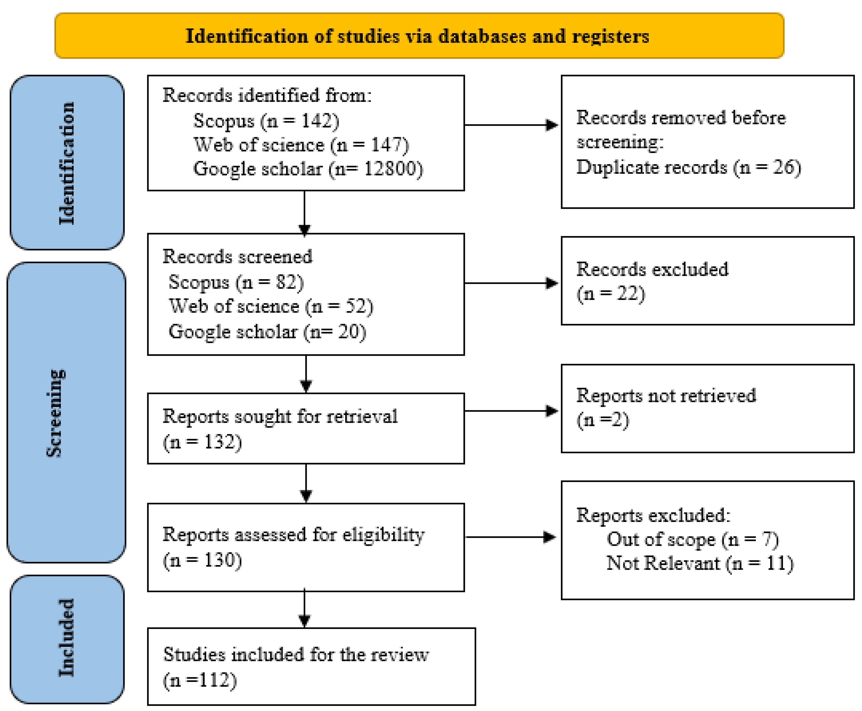
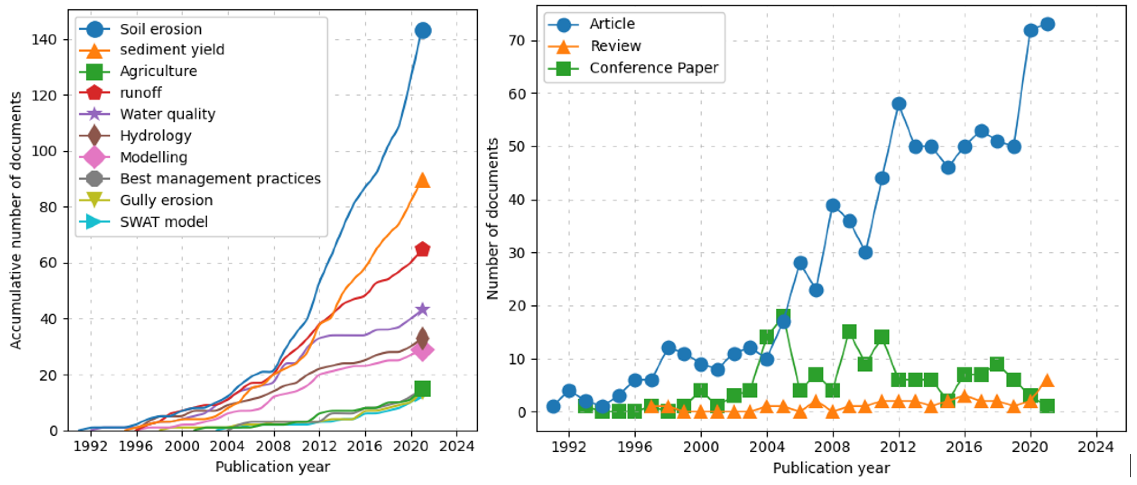
2. Methods
3. Results and Discussion
3.1. Erosion and Sediment Modeling
3.1.1. Description of Erosion and Sediment Models
3.1.2. Erosion Modeling Capability
3.1.3. Spatial Scale of Models
3.1.4. Temporal Scale of Models
3.1.5. Model Performance Evaluation
3.2. Model Selection
4. Summary and Conclusions
Author Contributions
Funding
Data Availability Statement
Acknowledgments
Conflicts of Interest
Abbreviations
| Model acronym | Model Name |
| AGNPS | Agricultural Nonpoint Source Model |
| AGWA | Automated Geospatial Watershed Assessment |
| ANSWERS | Areal Nonpoint Source Watershed Environment Response Simulation |
| AnnAGNPS | Annualized Agricultural Nonpoint Source Model |
| APEX | Agricultural Policy/ Environmental eXtender |
| CAESAR | Cellular Automaton Evolutionary Slope and River model |
| CASC2D | CASCade 2Dimentional |
| CREAMS | Chemicals, Runoff, and Erosion from Agricultural Management Systems |
| DWSM | Dynamic Watershed Simulation Model |
| EGEM | Ephemeral Gully Erosion Model |
| EROSION-2D/3D | No acronym |
| EPIC | Erosion–Productivity Impact Calculator |
| EPM | Erosion Potential Method |
| EUROSEM | European Soil Erosion Model |
| GLEAMS | Groundwater Loading Effects of Agricultural Management Systems |
| GSSHA | Gridded Surface/ Subsurface Hydrologic Analysis |
| GUEST | Griffiths University Erosion System Template |
| HEM | Hillslope Erosion Model |
| IDEAL | Integrated Design and Evaluation of Loading Models |
| KINEROS | Kinematic Runoff and Erosion Model |
| LASCAM | Large-Scale Catchment Model |
| LISEM | Limburg Soil Erosion Model |
| MEDALUS | Mediterranean Desertification and Land Use Research Programme Model |
| MEFIDIS | Modelo de ErosaoFIsico e DIStribuido |
| MIKE11 | Mike (named partially after the author Michael, Mike Abbott) |
| MIKE-SHE | Systeme Hydrologique Europeen |
| MUSLE | Modified Universal Soil Loss Equation |
| MMMF | Modified Morgan, Morgan and Finney |
| OPUS | No acronym |
| PEPP-HILLFLOW | Process-Oriented Erosion Prediction Program |
| PERFECT | Productivity, Erosion and Runoff, Functions to Evaluate Conservation Techniques |
| PESERA | Pan-European Soil Erosion Risk Assessment Model |
| PSIAC | Pacific Southwest Inter-aAency Committee Method |
| RillGrow | No acronym |
| RUNOFF | No acronym |
| RUSLE | Revised Universal Soil Loss Equation |
| SEDD | Sediment Delivery Distributed |
| SedNet | Sediment river network model |
| SHE/SHESED | Systeme Hydrologique Europian/Systeme Hydrologique Europian Sediment |
| SHETRAN | European Distributed Basin Flow and Transport Modeling System |
| STREAM | Sealing, Transfer, Runoff, Erosion, Agricultural Modification Model |
| SWAT | Soil and Water Assessment Tool |
| SWIM | Soil and Water Integrated Model |
| SWM/HSPF | Hydrologic Simulation Program, Fortran |
| SWRRB | Simulator for Water Resources in Rural Basins |
| TMDL | Total Maximum Daily Load |
| TOPOG | The Terrain Analysis Hydrologic Model |
| TOPMODEL | TOPMODEL |
| USLE | Universal Soil Loss Equation |
| USPED | Unit Stream Power-Based Erosion Deposition |
| WATEM/SEDEM | Water and Tillage Erosion Model |
| WEPP | Watershed Erosion Prediction Project |
| WESP | Watershed Erosion Simulation Program |
References
- Hurni, H. Soil Conservation Manual for Ethiopia; Ministry of Agriculture, Natural Resources Conservation; Development Main Department; Community Forests and Soil Conservation Development Department: Addis Ababa, Ethiopia, 1985.
- Adams, R.; Arafat, Y.; Eate, V.; Grace, M.R.; Saffarpour, S.; Weatherley, A.J.; Western, A.W. A catchment study of sources and sinks of nutrients and sediments in south-east Australia. J. Hydrol. 2014, 515, 166–179. [Google Scholar] [CrossRef]
- Jeanneau, A.; Herrmann, T.; Ostendorf, B. Mapping the spatio-temporal variability of hillslope erosion with the G2 model and GIS: A case-study of the South Australian agricultural zone. Geoderma 2021, 402, 115350. [Google Scholar] [CrossRef]
- Debie, E.; Awoke, Z. Assessment of the effects of land use/cover changes on soil loss and sediment export in the Tul Watershed, Northwest Ethiopia using the RUSLE and InVEST models. Int. J. River Basin Manag. 2023, 1–16. [Google Scholar] [CrossRef]
- Lim, K.J.; Sagong, M.; Engel, B.A.; Tang, Z.; Choi, J.; Kim, K.-S. GIS-based sediment assessment tool. Catena 2005, 64, 61–80. [Google Scholar] [CrossRef]
- Weifeng, Z.; Bingfang, W. Assessment of soil erosion and sediment delivery ratio using remote sensing and GIS: A case study of upstream Chaobaihe River catchment, north China. Int. J. Sediment Res. 2008, 23, 167–173. [Google Scholar]
- Khanbilvardi, R.; Rogowski, A. Quantitative evaluation of sediment delivery ratios. JAWRA J. Am. Water Resour. Assoc. 1984, 20, 865–874. [Google Scholar] [CrossRef]
- Hajigholizadeh, M.; Melesse, A.M.; Fuentes, H.R. Erosion and sediment transport modelling in shallow waters: A review on approaches, models and applications. Int. J. Environ. Res. Public Health 2018, 15, 518. [Google Scholar] [CrossRef] [PubMed] [Green Version]
- Wang, Z.Y.; Lin, B. Sediment studies and management strategies in China. Int. J. River Basin Manag. 2004, 2, 39–50. [Google Scholar] [CrossRef]
- Kalin, L.; Hantush, M.M. Evaluation of Sediment Transport Models and Comparative Application of Two Watershed Models; U.S. Environmental Protection Agency: Washington, DC, USA, 2003.
- James, S.C.; Jones, C.A.; Grace, M.D.; Roberts, J.D. Advances in sediment transport modelling. J. Hydraul. Res. 2010, 48, 754–763. [Google Scholar] [CrossRef]
- Bello, A.A.D.; Hashim, N.B.; Haniffah, R.M. Impact of urbanization on the sediment yield in tropical watershed using temporal land-use changes and a GIS-based model. J. Water Land Dev. 2017, 34, 33–45. [Google Scholar] [CrossRef] [Green Version]
- Aksoy, H.; Kavvas, M.L. A review of hillslope and watershed scale erosion and sediment transport models. Catena 2005, 64, 247–271. [Google Scholar] [CrossRef]
- Pickup, G.; Marks, A. Identifying large-scale erosion and deposition processes from airborne gamma radiometrics and digital elevation models in a weathered landscape. Earth Surf. Process. Landf. 2000, 25, 535–557. [Google Scholar] [CrossRef]
- Croke, J.; Todd, P.; Thompson, C.; Watson, F.; Denham, R.; Khanal, G. The use of multi temporal LiDAR to assess basin-scale erosion and deposition following the catastrophic January 2011 Lockyer flood, SE Queensland, Australia. Geomorphology 2013, 184, 111–126. [Google Scholar] [CrossRef]
- Simon, A.; Rinaldi, M. Disturbance, stream incision, and channel evolution: The roles of excess transport capacity and boundary materials in controlling channel response. Geomorphology 2006, 79, 361–383. [Google Scholar] [CrossRef]
- Gurnell, A.; Piégay, H.; Swanson, F.; Gregory, S. Large wood and fluvial processes. Freshw. Biol. 2002, 47, 601–619. [Google Scholar] [CrossRef] [Green Version]
- Harmon, R.S.; Doe, W.W., III. Landscape Erosion and Evolution Modeling; Springer Science & Business Media: Berlin/Heidelberg, Germany, 2001. [Google Scholar]
- Kumar, S. Geospatial approach in modeling soil erosion processes in predicting soil erosion and nutrient loss in hilly and mountainous landscape. Remote Sens. Northwest Himal. Ecosyst. 2019, 355–380. [Google Scholar]
- Martinez, C.; Hancock, G.R.; Kalma, J.D. Comparison of fallout radionuclide (caesium-137) and modelling approaches for the assessment of soil erosion rates for an uncultivated site in south-eastern Australia. Geoderma 2009, 151, 128–140. [Google Scholar] [CrossRef]
- Raza, A.; Ahrends, H.; Habib-Ur-Rahman, M.; Gaiser, T. Modeling approaches to assess soil erosion by water at the field scale with special emphasis on heterogeneity of soils and crops. Land 2021, 10, 422. [Google Scholar] [CrossRef]
- Borrelli, P.; Alewell, C.; Alvarez, P.; Anache, J.A.A.; Baartman, J.; Ballabio, C.; Bezak, N.; Biddoccu, M.; Cerda, A.; Chalise, D.; et al. Soil erosion modelling: A global review and statistical analysis. Sci. Total Environ. 2021, 780, 146494. [Google Scholar] [CrossRef]
- Merritt, W.S.; Letcher, R.A.; Jakeman, A.J. A review of erosion and sediment transport models. Environ. Model. Softw. 2003, 18, 761–799. [Google Scholar] [CrossRef]
- Desta, G.; Tamene, L.; Abera, W.; Amede, T.; Whitbread, A. Effects of land management practices and land cover types on soil loss and crop productivity in Ethiopia: A review. Int. Soil Water Conserv. Res. 2021, 9, 544–554. [Google Scholar] [CrossRef]
- Pandey, A.; Himanshu, S.K.; Mishra, S.K.; Singh, V.P. Physically based soil erosion and sediment yield models revisited. Catena 2016, 147, 595–620. [Google Scholar] [CrossRef]
- Bezak, N.; Mikos, M.; Borrelli, P.; Alewell, C.; Alvarez, P.; Anache, J.A.A.; Baartman, J.; Ballabio, C.; Biddoccu, M.; Cerdà, A.; et al. Soil erosion modelling: A bibliometric analysis. Environ. Res. 2021, 197, 111087. [Google Scholar] [CrossRef]
- De Vente, J.; Poesen, J.; Verstraeten, G.; Govers, G.; Vanmaercke, M.; Van Rompaey, A.; Arabkhedri, M.; Boix-Fayos, C. Predicting soil erosion and sediment yield at regional scales: Where do we stand? Earth-Sci. Rev. 2013, 127, 16–29. [Google Scholar] [CrossRef]
- Malede, D.A.; Agumassie, T.A.; Kosgei, J.R.; Andualem, T.G.; Diallo, I. Recent approaches to climate change impacts on hydrological extremes in the Upper Blue Nile Basin, Ethiopia. Earth Syst. Environ. 2022, 6, 669–679. [Google Scholar] [CrossRef]
- Page, M.J.; McKenzie, J.E.; Bossuyt, P.M.; Boutron, I.; Hoffmann, T.C.; Mulrow, C.D.; Shamseer, L.; Tetzlaff, J.M.; Akl, E.A.; Brennan, S.E. The PRISMA 2020 statement: An updated guideline for reporting systematic reviews. Int. J. Surg. 2021, 88, 105906. [Google Scholar] [CrossRef] [PubMed]
- Walling, D.E. The Impact of Global Change on Erosion and Sediment Transport by Rivers: Current Progress and Future Challenges; UNESCO: Paris, France, 2009. [Google Scholar]
- Kunta, K. Effects of Geographic Information Quality on Soil Erosion Prediction; ETH Zurich: Zürich, Switzerland, 2009; Volume 103. [Google Scholar]
- De Roo, A.P.J.; Jetten, V.G. Modelling soil erosion by water at the catchment scale: Preface. Catena 1999, 37, 275–276. [Google Scholar] [CrossRef]
- Peñuela, A.; Sellami, H.; Smith, H.G. A model for catchment soil erosion management in humid agricultural environments. Earth Surf. Process. Landf. 2018, 43, 608–622. [Google Scholar] [CrossRef]
- Aksoy, H.; Unal, N.E.; Cokgor, S.; Gedikli, A.; Yoon, J.; Koca, K.; Inci, S.B.; Eris, E. A rainfall simulator for laboratory-scale assessment of rainfall-runoff-sediment transport processes over a two-dimensional flume. Catena 2012, 98, 63–72. [Google Scholar] [CrossRef]
- Arguelles, A.C.C.; Jung, M.; Mallari, K.J.B.; Pak, G.; Aksoy, H.; Kavvas, L.M.; Eris, E.; Yoon, J.; Lee, Y.; Hong, S. Evaluation of an erosion-sediment transport model for a hillslope using laboratory flume data. J. Arid. Land 2014, 6, 647–655. [Google Scholar] [CrossRef] [Green Version]
- Wirtz, S.; Seeger, M.; Ries, J. Field experiments for understanding and quantification of rill erosion processes. Catena 2012, 91, 21–34. [Google Scholar] [CrossRef]
- Hughes, S.A. Physical Models and Laboratory Techniques in Coastal Engineering; World Scientific: Singapore, 1993; Volume 7. [Google Scholar]
- Yibeltal, M.; Tsunekawa, A.; Haregeweyn, N.; Adgo, E.; Meshesha, D.T.; Zegeye, A.D.; Andualem, T.G.; Oh, S.J.; Lee, J.C.; Kang, M.W. Analyzing the contribution of gully erosion to land degradation in the upper Blue Nile basin, Ethiopia. J. Environ. Manag. 2023, 344, 118378. [Google Scholar] [CrossRef]
- Lorup, J.K.; Styczew, M. Soil erosion modelling. In Distributed Hydrological Modelling; Abbott, M.B., Refsgaard, J.C., Eds.; Kluwer Academic Publisher: London, UK, 1996. [Google Scholar]
- Doe, W.W.; Harmon, R.S. Introduction to soil erosion and landscape evolution modeling. In Landscape Erosion and Evolution Modeling; Springer: Berlin/Heidelberg, Germany, 2001; pp. 1–14. [Google Scholar]
- Refsgaard, J.C. Terminology, modelling protocol and classification of hydrological model codes. In Distributed Hydrological Modelling; Abbott, M.B., Refsgaard, J.C., Eds.; Kluwer Academic Publishers: London, UK, 1996. [Google Scholar]
- Young, R.A.; Onstad, C.; Bosch, D.; Singh, V. AGNPS: An agricultural nonpoint source model. In Proceedings of the Workshop on Computer Applications in Water Management, Fort Collins, CO, USA, 23–25 May 1995. [Google Scholar]
- Bingner, R.; Theurer, F.; Yuan, Y. AnnAGNPS Technical Processes: Documentation Version 2; Unpublished Report; USDA-ARS National Sedimentation Laboratory: Oxford, MS, USA, 2001. [Google Scholar]
- Viney, N.R.; Sivapalan, M. A distributed model of large scale catchment hydrology. In Water Down Under 94: Surface Hydrology and Water Resources Papers; Institute of Engineers: Barton, ACT, Australia, 1994; pp. 417–422. [Google Scholar]
- Morgan, R.P.C. A-simple-approach-to-soil-loss-prediction-A-revised-Morgan-Morgan-Finney-model. Catena 2000, 44, 305–322. [Google Scholar] [CrossRef]
- Favis-Mortlock, D.; Guerra, T.; Boardman, J. A self-organizing dynamic systems approach to hillslope rill initiation and growth: Model development and validation. IAHS Publ. 1998, 53–62. [Google Scholar]
- Prosser, I.P.; Young, W.J.; Rustomji, P.; Hughes, A.O.; Moran, C.J. A model of river sediment budgets as an element of river health assessment. In Proceedings of the MODSIM 2001—International Congress on Modelling and Simulation, Canberra, Australia, 10–13 December 2001. [Google Scholar]
- Cerdan, O.; Souchère, V.; Lecomte, V.; Couturier, A.; Le Bissonnais, Y. Incorporating soil surface crusting processes in an expert-based runoff model: Sealing and Transfer by Runoff and Erosion related to Agricultural Management. Catena 2002, 46, 189–205. [Google Scholar] [CrossRef]
- Arnold, J.G.; Srinivasan, R.; Muttiah, R.S.; Williams, J.R. Large area hydrologic modeling and assessment part I: Model development 1. JAWRA J. Am. Water Resour. Assoc. 1998, 34, 73–89. [Google Scholar] [CrossRef]
- Krysanova, V.; Wechsung, F.; Arnold, J.; Srinivasan, R.; Williams, J. SWIM (Soil and Water Integrated Model); Potsdam-Institut fuer Klimafolgenforschung (PIK): Potsdam, Germany, 2000. [Google Scholar]
- Johanson, R.C.; Imhoff, J.C.; Davis, H.H. Users Manual for Hydrological Simulation Program-Fortran (HSPF); Environmental Research Laboratory, Office of Research and Development, US: Greenville, NC, USA, 1980; Volume 80.
- Williams, J.R.; Nicks, A.; Arnold, J.G. Simulator for water resources in rural basins. J. Hydraul. Eng. 1985, 111, 970–986. [Google Scholar] [CrossRef]
- Beven, K.; Freer, J. A dynamic TOPMODEL. Hydrol. Process. 2001, 15, 1993–2011. [Google Scholar] [CrossRef]
- Mitasova, H.; Brown, W.; Johnston, D.; Mitas, L. GIS tools for erosion/deposition modeling and multidimensional visualization. In PART II: Unit Stream Power-Based Erosion/Deposition Modeling and Enhanced Dynamic Visualization; Report for USA CERL; University of Illinois: Urbana-Champaign, IL, USA, 1996; p. 38. [Google Scholar]
- Van Oost, K.; Govers, G.; Desmet, P. Evaluating the effects of changes in landscape structure on soil erosion by water and tillage. Landsc. Ecol. 2000, 15, 577–589. [Google Scholar] [CrossRef]
- Woodward, D.E. Method to predict cropland ephemeral gully erosion: Soil erosion modelling at the catchment scale. Catena 1999, 37, 393–399. [Google Scholar] [CrossRef]
- Williams, J.; Renard, K.; Dyke, P. EPIC: A new method for assessing erosion’s effect on soil productivity. J. Soil Water Conserv. 1983, 38, 381–383. [Google Scholar]
- Dragičević, N.; Karleuša, B.; Ožanić, N. Erosion potential method (Gavrilović Method) sensitivity analysis. Soil Water Res. 2017, 12, 51–59. [Google Scholar] [CrossRef] [Green Version]
- Williams, J.; Berndt, H. Sediment yield prediction based on watershed hydrology. Trans. ASAE 1977, 20, 1100–1104. [Google Scholar] [CrossRef]
- Daneshvar, M.R.M.; Bagherzadeh, A. Evaluation of sediment yield in PSIAC and MPSIAC models by using GIS at Toroq Watershed, Northeast of Iran. Front. Earth Sci. 2012, 6, 83–94. [Google Scholar] [CrossRef]
- Wischmeier, W.H.; Smith, D.D. Predicting Rainfall Erosion Losses: A Guide to Conservation Planning; Department of Agriculture, Science and Education Administration: Washington, DC, USA, 1978. [Google Scholar]
- Ferro, V.; Porto, P. Sediment delivery distributed (SEDD) model. J. Hydrol. Eng. 2000, 5, 411–422. [Google Scholar] [CrossRef] [Green Version]
- Hoornbeek, J.; Hansen, E.; Ringquist, E.; Carlson, R. Implementing Total Maximum Daily Loads: Understanding and Fostering Successful Results; Center for Public Administration and Public Policy, Kent State University: Kent, OH, USA, 2008. [Google Scholar]
- Burns, I.; Scott, S.; Levick, L.; Hernandez, M.; Goodrich, D.; Miller, S.; Semmens, D.; Kepner, W. Automated Geospatial Watershed Assessment (AGWA)-A GIS-Based Hydrologic Modeling Tool: Documentation and User Manual. ARS-1446. US Department of Agriculture, Agricultural Research Service. 2004. Available online: http://www.epa.gov/esd/land-sci/agwa/manual/01abstract/abstract.htm (accessed on 27 June 2023).
- Beasley, D.; Huggins, L.; Monke, A. ANSWERS: A model for watershed planning. Trans. ASAE 1980, 23, 938–0944. [Google Scholar] [CrossRef]
- Coulthard, T.; Van De Wiel, M.J. The Cellular Automaton Evolutionary Slope and River Model (CAESAR). In Accounting for Sediment in Rivers; Western Libraries: London, UK, 2006. [Google Scholar]
- Johnson, B.E.; Julien, P.Y.; Molnar, D.K.; Watson, C.C. The Two-Dimensional Upland Erosion Model CASC2D-SED 1. JAWRA J. Am. Water Resour. Assoc. 2000, 36, 31–42. [Google Scholar] [CrossRef]
- Knisel, W.G. CREAMS: A Field Scale Model for Chemicals, Runoff, and Erosion from Agricultural Management Systems; Department of Agriculture, Science and Education Administration: Washington, DC, USA, 1980. [Google Scholar]
- Borah, D.K.; Bera, M.; Shaw, S.; Keefer, L. Dynamic Modeling and Monitoring of Water, Sediment, Nutrients, and Pesticides in Agricultural Watersheds during Storm Events. ISWS Contract Report. CR 655. 1999. Available online: https://core.ac.uk/download/pdf/158316885.pdf (accessed on 27 June 2023).
- Schmidt, J.; Werner, M.V.; Michael, A. Application of the EROSION 3D model to the CATSOP watershed, The Netherlands: Soil erosion modelling at the catchment scale. Catena 1999, 37, 449–456. [Google Scholar] [CrossRef]
- Morgan, R.; Quinton, J.; Smith, R.; Govers, G.; Poesen, J.; Auerswald, K.; Chisci, G.; Torri, D.; Styczen, M. The European Soil Erosion Model (EUROSEM): A dynamic approach for predicting sediment transport from fields and small catchments. Earth Surf. Process. Landf. J. Br. Geomorphol. Group 1998, 23, 527–544. [Google Scholar] [CrossRef]
- Leonard, R.; Knisel, W.; Davis, F. Modelling pesticide fate with GLEAMS. Eur. J. Agron. 1995, 4, 485–490. [Google Scholar] [CrossRef]
- Ogden, F.L.; Downer, C.W.; Meselhe, E. US army corps of engineers gridded surface/subsurface hydrologic analysis (GSSHA) model: Distributed-parameter, physically based watershed simulations. In Proceedings of the World Water & Environmental Resources Congress 2003, Philadelphia, PA, USA, 23–26 June 2003; pp. 1–10. [Google Scholar]
- Rose, C.W.; Coughlan, K.J.; Fentie, B. Griffith University Erosion System Template (GUEST). In Modelling Soil Erosion by Water; Springer: Berlin/Heidelberg, Germany, 1998; pp. 399–412. [Google Scholar]
- Lane, L.; Shirley, E.; Singh, V. Modelling erosion on hillslopes. Model. Geomorphol. Syst. 1988, 287–308. [Google Scholar]
- Woolhiser, D.A.; Smith, R.E.; Goodrich, D.C. KINEROS: A Kinematic RUNOFF and Erosion model: Documentation and User Manual; ARS Series 77; U.S. Dept. of Agriculture, Agricultural Research Service: Washington, DC, USA, 1990. [Google Scholar]
- De Roo, A.; Wesseling, C.; Ritsema, C. LISEM: A single-event physically based hydrological and soil erosion model for drainage basins. I: Theory, input and output. Hydrol. Process. 1996, 10, 1107–1117. [Google Scholar] [CrossRef]
- Kirkby, M. Modelling across scales: The MEDALUS family of models. In Modelling Soil Erosion by Water; Springer: Berlin/Heidelberg, Germany, 1998; pp. 161–173. [Google Scholar]
- Shamsudin, S.; Hashim, N. Rainfall runoff simulation using MIKE11 NAM. Malays. J. Civ. Eng. 2002, 15, 26–38. [Google Scholar]
- Abbott, M.; Clarke, R.; Preissmann, A. Logistics and benefits of the European Hydrologic System. Logist. Benefits Using Math. Models Hydrol. Water Resour. Syst. 1978, 191. [Google Scholar]
- Heatwole, C.D.; Zacharias, S.; Workman, S.R. Opus: Model Description and Evaluation; Parsons, J.E., Thomas, D.L., Huffman, R.L., Eds.; Southern Cooperative Series Bulletin #398; ASAE: Asheville, NC, USA, 2001; p. 92. [Google Scholar]
- Schramm, M. Ein Erosionsmodell mit Räumlich und Zeitlich Veränderlicher Rillenmorphologie; Fakultät für Bauingenieur-und Vermessungswese der Universität Fridericiana: Karlsruhe, Germany, 1994. [Google Scholar]
- Littleboy, M.; Silburn, D.; Freebairn, D.; Woodruff, D.; Hammer, G. PERFECT. Productivity Erosion, Runoff Functions to Evaluate Conservation Techniques; Training Series QE93010; Dept. of Primary Industries: Brisbane, Australia, 1989.
- Irvine, B.; Cosmas, C. PESERA (Pan-European Soil Erosion Risk Assessment Model). In PESERA User’s Manual; European Commission: Brussels, Belgium, 2003. [Google Scholar]
- Borah, D. Sediment discharge model for small watersheds. Trans. ASAE 1989, 32, 874–0880. [Google Scholar] [CrossRef]
- Abbott, M.B.; Bathurst, J.C.; Cunge, J.A.; O’Connell, P.E.; Rasmussen, J. An introduction to the European Hydrological System—Systeme Hydrologique Europeen, “SHE”, 1: History and philosophy of a physically-based, distributed modelling system. J. Hydrol. 1986, 87, 45–59. [Google Scholar] [CrossRef]
- Ewen, J.; Parkin, G.; O’Connell, P.E. SHETRAN: Distributed river basin flow and transport modeling system. J. Hydrol. Eng. 2000, 5, 250–258. [Google Scholar] [CrossRef] [Green Version]
- Vertessy, R.; Wilson, C.; Silburn, D.; Connolly, R.; Ciesiolka, C. Predicting erosion hazard areas using digital terrain analysis. Predict. Eros. Hazard Areas Using Digit. Terrain Anal. 1990, 192, 298–308. [Google Scholar]
- Laflen, J.M.; Lane, L.J.; Foster, G.R. WEPP: A new generation of erosion prediction technology. J. Soil Water Conserv. 1991, 46, 34–38. [Google Scholar]
- Lopes, V.L. A Numerical Model of Watershed Erosion and Sediment Yield (Runoff); The University of Arizona: Tucson, AZ, USA, 1987. [Google Scholar]
- Tuppad, P.; Winchell, M.; Wang, X.; Srinivasan, R.; Williams, J. ArcAPEX: ArcGIS interface for Agricultural Policy Environmental eXtender (APEX) hydrology/water quality model. Int. Agric. Eng. J. 2009, 18, 59. [Google Scholar]
- Barfield, B.J.; Hayes, J.; Harp, S.; Holbrook, K.; Gillespie, J. IDEAL: Integrated design and evaluation assessment of loadings model. In Watershed Models; CRC: Boca Raton, FL, USA, 2005; pp. 361–380. [Google Scholar]
- Nunes, J.P.; Vieira, G.N.; Seixas, J. MEFIDIS–A physically-based, spatially-distributed runoff and erosion model for extreme rainfall events. Watershed Models 2006, 291–314. [Google Scholar]
- Nearing, M.; Lane, L.J.; Lopes, V.L. Modeling soil erosion. In Soil Erosion Research Methods; Routledge: London, UK, 2017; pp. 127–158. [Google Scholar]
- Wu, L.; Liu, X.; Ma, X. Application of a modified distributed-dynamic erosion and sediment yield model in a typical watershed of a hilly and gully region, Chinese Loess Plateau. Solid Earth 2016, 7, 1577–1590. [Google Scholar] [CrossRef] [Green Version]
- Refsgaard, J.C.; Abbott, M.B. A discussion on Constraints for the Practical Use of Distributed Hydrological Modelling in Water Resources Management. In Distributed Hydrological Modelling; Abbott, M.B., Refsgaard, J.C., Eds.; Kluwer Academic Publishers: London, UK, 1996. [Google Scholar]
- Refsgaard, J.C.; Storm, B. Construction, calibration and validation of hydrological models. In Distributed Hydrological Modelling; Abbott, M.B., Refsgaard, J.C., Eds.; Kluwer Academic Publishers: London, UK, 1996. [Google Scholar]
- Mutua, B.M.; Klik, A.; Loiskandl, W. Modelling soil erosion and sediment yield at a catchment scale: The case of Masinga catchment, Kenya. Land Degrad. Dev. 2006, 17, 557–570. [Google Scholar] [CrossRef]
- Bormann, H.; Breuer, L.; Giertz, S.; Huisman, J.A.; Viney, N.R. Spatially explicit versus lumped models in catchment hydrology–experiences from two case studies. In Uncertainties in Environmental Modelling and Consequences for Policy Making; Springer: Berlin/Heidelberg, Germany, 2009; pp. 3–26. [Google Scholar]
- Berthet, L.; Andréassian, V.; Perrin, C.; Javelle, P. How crucial is it to account for the antecedent moisture conditions in flood forecasting? Comparison of event-based and continuous approaches on 178 catchments. Hydrol. Earth Syst. Sci. 2009, 13, 819–831. [Google Scholar] [CrossRef] [Green Version]
- Martinec, J.; Rango, A. Merits of statistical criteria for the performance of hydrological MODELS 1. JAWRA J. Am. Water Resour. Assoc. 1989, 25, 421–432. [Google Scholar] [CrossRef]
- Moriasi, D.N.; Gitau, M.W.; Pai, N.; Daggupati, P. Hydrologic and water quality models: Performance measures and evaluation criteria. Trans. ASABE 2015, 58, 1763–1785. [Google Scholar]
- Rafiei, V.; Ghahramani, A.; An-Vo, D.A.; Mushtaq, S. Modelling hydrological processes and identifying soil erosion sources in a tropical catchment of the great barrier reef using SWAT. Water 2020, 12, 2179. [Google Scholar] [CrossRef]
- Setegn, S.G.; Srinivasan, R.; Dargahi, B.; Melesse, A.M. Spatial delineation of soil erosion vulnerability in the Lake Tana Basin, Ethiopia. Hydrol. Process. Int. J. 2009, 23, 3738–3750. [Google Scholar] [CrossRef]
- Wu, Y.; Chen, J. Modeling of soil erosion and sediment transport in the East River Basin in southern China. Sci. Total Environ. 2012, 441, 159–168. [Google Scholar] [CrossRef] [PubMed]
- Borah, D.; Bera, M. Watershed-scale hydrologic and nonpoint-source pollution models: Review of mathematical bases. Trans. ASAE 2003, 46, 1553. [Google Scholar] [CrossRef] [Green Version]
- Young, R.; Onstad, C.; Bosch, D.; Anderson, W. AGNPS: A nonpoint-source pollution model for evaluating agricultural watersheds. J. Soil Water Conserv. 1989, 44, 168–173. [Google Scholar]
- Morgan, R.; Morgan, D.; Finney, H. A predictive model for the assessment of soil erosion risk. J. Agric. Eng. Res. 1984, 30, 245–253. [Google Scholar] [CrossRef]
- Abdelwahab, O.M.M.; Ricci, G.F.; De Girolamo, A.M.; Gentile, F. Modelling soil erosion in a Mediterranean watershed: Comparison between SWAT and AnnAGNPS models. Environ. Res. 2018, 166, 363–376. [Google Scholar] [CrossRef] [PubMed]


| Model Acronym | Space Domain | Time Domain | Scale | GIS Integration | Modeling Capability | Model Limitation | Model Type | Source | |||
|---|---|---|---|---|---|---|---|---|---|---|---|
| L | D | C | E | F | W | ||||||
| AGNPS | ✓ | ✓ | ✓ | High | Er, SY, R, nutrient | Suitable for catchments, simulates only single rainfall events | Conceptual | [42] | |||
| AnnAGNPS | ✓ | ✓ | ✓ | High | SY, R, nutrient | Requires large data input, does not allow for spatial variablity of rainfall | Conceptual | [43] | |||
| LASCAM | ✓ | ✓ | ✓ | ✓ | High | SL, R, salt fluxes | Low prediction capacity during calibration | Conceptual | [44] | ||
| MMMF | ✓ | ✓ | ✓ | ER, R, SY, SD | Conceptual | [45] | |||||
| RillGrow | ✓ | ✓ | ✓ | Low | Rill formation | Simulates only single rainfall events | Conceptual | [46] | |||
| SedNet | ✓ | ✓ | ✓ | SS, SD, overland flow | Conceptual | [47] | |||||
| STREAM | ✓ | ✓ | ✓ | Er, ST | Simulates only single rainfall events | Conceptual | [48] | ||||
| SWAT | ✓ | ✓ | ✓ | ✓ | High | Er, SY, R, nutrient | Requires large data input, low capacity in stream channel erosion and deposition analysis | Conceptual | [49] | ||
| SWIM | ✓ | ✓ | ✓ | High | SL, R, nutrient | Does not simulate gully erosion, relatively complex | Conceptual | [50] | |||
| SWM/HSPF | ✓ | ✓ | ✓ | High | SL, R, nutrient | Requires calibration of several parameters | Conceptual | [51] | |||
| SWRRB | ✓ | ✓ | ✓ | ✓ | Moderate | sediment, R, nutrient and pesticide | Uncertainty in model parameter estimations | Conceptual | [52] | ||
| TOPMODEL | ✓ | ✓ | ✓ | ✓ | High | SY, R | Suitable only for shallow homogenous soil watersheds | Conceptual | [53] | ||
| USPED | ✓ | ✓ | ✓ | Er | Conceptual | [54] | |||||
| WATEM/SEDEM | ✓ | ✓ | ✓ | Moderate | Er, Dp, ST | Requires large data input | Conceptual | [55] | |||
| EGEM | ✓ | ✓ | ✓ | ✓ | ✓ | High | Gully formation | Requires large data input | Empirical | [56] | |
| EPIC | ✓ | ✓ | ✓ | ✓ | Low | SL, nutrient | Limited to field-scale application only | Empirical | [57] | ||
| EPM | ✓ | ✓ | ✓ | EI, SP, ST | Model performance subjected to specific characteristics and sedimentary regime | Empirical | [58] | ||||
| MUSLE | ✓ | ✓ | ✓ | High | Er, SY | Complexity for calibration | Empirical | [59] | |||
| PSIAC | ✓ | ✓ | ✓ | Upland and channel Er, Dp | Model is sensitive to changes of different factors | Empirical | [60] | ||||
| RUSLE | ✓ | ✓ | ✓ | High | Er, process-based | Does not simulate gully or stream-channel erosion, not suitable for slope length factor more than 25 | Empirical | [61] | |||
| SEDD | ✓ | ✓ | ✓ | SY | Reliability of model decreases from the annual scale to the event scale | Empirical | [62] | ||||
| TMDL | ✓ | ✓ | ✓ | SL, nutrients | Needs conversion of transport capacity into erosion coefficient, factor determination is difficult | Empirical | [63] | ||||
| USLE | ✓ | ✓ | ✓ | Er | Does not simulate events that are likely to result in large-scale erosion | Empirical | [61] | ||||
| AGWA | ✓ | ✓ | ✓ | High | Er, SY, R, nutrients | Physically-based | [64] | ||||
| ANSWERS | ✓ | ✓ | ✓ | High | Er, SY, R, nutrients | Consider erodibility as a time-constant parameter | Physically-based | [65] | |||
| CAESAR | ✓ | ✓ | ✓ | Er, ST | No rainfall–runoff interaction | Physically-based | [66] | ||||
| CASC2D | ✓ | ✓ | ✓ | ✓ | Low | SY, Er/Dp | Does not simulate sub-surface flow, reservoir flow and channel sediment, and relies on a single storm event | Physically-based | [67] | ||
| CREAMS | ✓ | ✓ | ✓ | ✓ | Low | Er, Dp | Physically-based | [68] | |||
| DWSM | ✓ | ✓ | ✓ | Moderate | Er, SY, R, flood, agrochemical transport | Slow computing speed, uncertainties in input parameter data | Physically-based | [69] | |||
| EROSION-2D/3D | ✓ | ✓ | ✓ | High | Sediment dynamics | Needs maximum computational efforts | Physically-based | [70] | |||
| EUROSEM | ✓ | ✓ | ✓ | High | Er, SY, R | Lesser precision for large catchments | Physically-based | [71] | |||
| GLEAMS | ✓ | ✓ | ✓ | ✓ | Low | Er, SY | Uncertainty in model validation and parameter estimation | Physically-based | [72] | ||
| GSSHA | ✓ | ✓ | ✓ | ✓ | High | Er, Dp, ST, detachment, raindrop impact | Does not simulate the sub-surface flow component | Physically-based | [73] | ||
| GUEST | ✓ | ✓ | ✓ | Low | SS, R | Requires large data input | Physically-based | [74] | |||
| HEM | ✓ | ✓ | ✓ | High | Er, SY, R, SC | Need specific conditions | Physically-based | [75] | |||
| KINEROS | ✓ | ✓ | ✓ | ✓ | High | Er, SY, R | Sub-surface flow is not considered for estimating runoff | Physically-based | [76] | ||
| LISEM | ✓ | ✓ | ✓ | High | SY, R | Requires large data input physical parameters | Physically-based | [77] | |||
| MEDALUS | ✓ | ✓ | ✓ | ✓ | Moderate | Er, impact of land use changes | Relies on recent data inputs only | Physically-based | [78] | ||
| MIKE11 | ✓ | ✓ | ✓ | ✓ | High | SY, R | Requires large data input and physical parameters, use of 1D equations to represent 3D processes | Physically-based | [79] | ||
| MIKE-SHE | ✓ | ✓ | ✓ | Er, SY | Physically-based | [80] | |||||
| OPUS | ✓ | ✓ | ✓ | High | Er, SS, R, nutrient | Physically-based | [81] | ||||
| PEPP-HILLFLOW | ✓ | ✓ | ✓ | Moderate | Er, Dp, sediment and phosphorous transport | Simulates only single rainfall events, large data input requirement | Physically-based | [82] | |||
| PERFECT | ✓ | ✓ | ✓ | Low | Er, SY, R | Require detailed information on crop management and tillage practices | Physically-based | [83] | |||
| PESERA | ✓ | ✓ | ✓ | High | Er, R | Flow routing is not well developed | Physically-based | [84] | |||
| RUNOFF | ✓ | ✓ | ✓ | High | Er, R, crop yield | Uncertainties in input parameter estimations and model validation | Physically-based | [85] | |||
| SHE/SHESED | ✓ | ✓ | ✓ | ✓ | High | Er, SY, R | Does not simulate gully erosion | Physically-based | [86] | ||
| SHETRAN | ✓ | ✓ | ✓ | High | SY, Er/ Dp, pollutants transport | Uses very large grids and does not simulate flow through an unsaturated zone | Physically-based | [87] | |||
| TOPOG | ✓ | ✓ | ✓ | Moderate | Erosion hazard, water logging, solute transport | Requires large data input and physical parameters | Physically-based | [88] | |||
| WEPP | ✓ | ✓ | ✓ | ✓ | Moderate | Er, SY, R | Requires large data input, does not simulate in permanent channels | Physically-based | [89] | ||
| WESP | ✓ | ✓ | ✓ | Moderate | Er, SY, R | Intensive computation of input parameters | Physically-based | [90] | |||
| APEX | ✓ | ✓ | ✓ | High | Er, land Management strategy, soil quality | Suitable only for field-scale and small catchments, less developed sub-surface drainage and water table fluctuation routine | Physically-based | [91] | |||
| IDEAL | ✓ | ✓ | ✓ | Low | SY, Er | Simulates only single rainfall events | Physically-based | [92] | |||
| MEFIDIS | ✓ | ✓ | ✓ | Low | Er, R | Soil erosion is based on extreme rainfall events, low potential for GIS integration | Physically-based | [93] | |||
| Modeling Focus | Erosion Type | Model Name |
|---|---|---|
| Sediment yield | Gross erosion | GLEAMS, GUEST, HEM PERFECT, PESERA, RUSLE, SWIM, USLE |
| Net erosion | AGNPS, AGWA, AnnAGNPS, ANSWERS, APEX, DWSM, EPM, HSPF, KINEROS, LISEM, MEDALUS, MEFIDIS, MMF, MUSLE, PSIAC, RUSLE/SEDD, RUSLE-SDR, SedNet, SHESED, SHETRAN, STREAM, SWAT, TOPOG, USLE2D, WEPP | |
| Sediment budget | Gross erosion | DWSM, RMMF/SEDD, SEDEM, USLE |
| Net erosion | CAESAR, EPM, Erosion2D/3D, EUROSEM, MUSLE, RUSLE-3D, RUSLE-SDR, SedNet, STREAM, SWAT, USLE-SDR, WEPP-Road | |
| Stream bank erosion | Gross erosion | USLE, RUSLE |
| Net erosion | WEPP, RUSLE-SDR, LISEM | |
| Riparian erosion | Gross erosion | MIKE-SHE, USLE, PESERA, RUSLE |
| Net erosion | GLEAMS, SWAT | |
| Rill erosion | Gross erosion | RUSLE, EPIC |
| Net erosion | USLE-SDR, RHEM | |
| Sheet and rill | Gross erosion | CREAMS, Erosion 3D, GLEAMS, PEPP, PERFECT, PESERA, RUSLE, RUSLE-SEDD, STREAM, USLE, |
| Net erosion | APEX, EPIC, HSPF, LISEM, MEDALUS, MMF, OPUS, RUSLE/SEDD, RUSLE-SDR, SED, SEDD, SEDEM, SLEMSA, USLE-SDR, WEPP | |
| Gully erosion | Gross erosion | CREAMS, EGEM, WEPP, AnnAGNPS-REGEM |
| Sediment Yield Models (Net Erosion) | Space Domain | Time Domain | Scale | Model Type | Source |
|---|---|---|---|---|---|
| SWAT | Distributed | Continuous | Watershed | Physically-based | [49] |
| AGWA | Distributed | Continuous | Watershed | Physically-based | [64] |
| AnnAGNPS | Distributed | Continuous | Watershed | Conceptual | [43] |
| SedNet | Distributed | Continuous | Watershed | Conceptual | [47] |
| WEPP | Distributed | Continuous | Watershed | Physically-based | [89] |
| SHESED | Distributed | Continuous | Watershed | Physically-based | [86] |
| EPM | Distributed | Continuous | Watershed | Empirical | [58] |
| APEX | Distributed | Continuous | Field | Physically-based | [91] |
| DWSM | Distributed | Event | Watershed | Physically-based | [69] |
| SHETRAN | Distributed | Event | Watershed | Physically-based | [87] |
| AGNPS | Distributed | Event | Watershed | Conceptual | [107] |
| ANSWERS | Distributed | Event | Watershed | Physically-based | [65] |
| TOPOG | Distributed | Event | Watershed | Physically-based | [88] |
| KINEROS | Distributed | Event | Watershed | Physically-based | [76] |
| LISEM | Distributed | Event | Watershed | Physically-based | [77] |
| MEDALUS | Distributed | Event | Plot | Physically-based | [78] |
| MEFIDIS | Distributed | Event | Watershed | Physically-based | [93] |
| MMF | Lumped | Continuous | Watershed | Conceptual | [108] |
| MUSLE | Lumped | Continuous | Watershed | Empirical | [59] |
| PSIAC | Lumped | Continuous | Watershed | Empirical | [60] |
| RUSLE/SEDD | Lumped | Continuous | Watershed | Empirical | [62] |
| HSPF | Lumped | Continuous | Watershed | Empirical | [51] |
| STREAM | Distributed | Event | Watershed | Conceptual | [48] |
| Sediment Yield Models | Net Erosion | Distributed | Continuous | Watershed | Process | Remark |
|---|---|---|---|---|---|---|
| AGWA | ✓ | ✓ | ✓ | ✓ | Physically-based | |
| AnnAGNPS | ✓ | ✓ | ✓ | ✓ | Conceptual | Does not provide information about deposition in reaches |
| SedNet | ✓ | ✓ | ✓ | ✓ | Conceptual | Applicable to areas > 3000 km2 |
| SHESED | ✓ | ✓ | ✓ | ✓ | Physically-based | |
| SWAT | ✓ | ✓ | ✓ | ✓ | Physically-based | |
| WEPP | ✓ | ✓ | ✓ | ✓ | Physically-based | Applicable to areas < 2 km2 |
Disclaimer/Publisher’s Note: The statements, opinions and data contained in all publications are solely those of the individual author(s) and contributor(s) and not of MDPI and/or the editor(s). MDPI and/or the editor(s) disclaim responsibility for any injury to people or property resulting from any ideas, methods, instructions or products referred to in the content. |
© 2023 by the authors. Licensee MDPI, Basel, Switzerland. This article is an open access article distributed under the terms and conditions of the Creative Commons Attribution (CC BY) license (https://creativecommons.org/licenses/by/4.0/).
Share and Cite
Andualem, T.G.; Hewa, G.A.; Myers, B.R.; Peters, S.; Boland, J. Erosion and Sediment Transport Modeling: A Systematic Review. Land 2023, 12, 1396. https://doi.org/10.3390/land12071396
Andualem TG, Hewa GA, Myers BR, Peters S, Boland J. Erosion and Sediment Transport Modeling: A Systematic Review. Land. 2023; 12(7):1396. https://doi.org/10.3390/land12071396
Chicago/Turabian StyleAndualem, Tesfa Gebrie, Guna A. Hewa, Baden R. Myers, Stefan Peters, and John Boland. 2023. "Erosion and Sediment Transport Modeling: A Systematic Review" Land 12, no. 7: 1396. https://doi.org/10.3390/land12071396