Article

Main Flow Migration in the Middle Yangtze River Influenced by Cascade Reservoirs: Characteristics, Controlling Factors, Trends, and Ecological Impact

1
Changjiang River Scientific Research Institute, Wuhan 430010, China
2
Key Laboratory of River & Lake Regulation and Flood Protection in the Middle and Lower Reaches of Changjiang River, Ministry of Water Resources, Wuhan 430010, China
3
Bureau of Hydrology, Changjiang Water Resources Commission, Wuhan 430010, China
*
Author to whom correspondence should be addressed.
Land 2023, 12(5), 975; https://doi.org/10.3390/land12050975
Submission received: 1 March 2023 / Revised: 17 April 2023 / Accepted: 25 April 2023 / Published: 27 April 2023
(This article belongs to the Topic Monitoring Inland Water Quality and Ecological Status)

Abstract

:
The main flow migration in the middle Yangtze River occurs in most river sections and is affected by factors such as incoming water and sediment, riverbed boundaries, and channel shapes, leading to a complex riverbed evolution. Revealing the controlling factors and analyzing the developmental trends are important for addressing the adverse ecological impacts caused by these changes. Based on a large amount of observational data since the impoundment of the Three Gorges Reservoir, the characteristics of the main flow migration in the middle Yangtze River under different flow conditions were analyzed, and its correlation with the nodes and bars at the inlet, the plane shape of the river, and riverbed morphology were determined to identify the key controlling factors. The results showed that it is characterized by the displacement of the main flow zone during the middle-flow period. The key factors controlling the main flow migration include the deflecting action of the nodes and sidebars at the inlet, relaxation of the channel plane shape, and resistance difference caused by the riverbed morphology between the branches. The trend analysis suggests that the main flow migration in the middle Yangtze River may become more frequent after the operation of the cascade reservoirs in the future and may threaten the ecological environment.

1. Introduction

Main flow migration is a typical manifestation of the change in the hydrodynamic characteristics of alluvial plain rivers. Its impact is complex and huge, not only changing the characteristics of water and sediment transport in local river sections but also causing the adjustment of local river regimes, such as the displacement of primary and secondary river branches, deformation of sand bars [1], erosion and collapse of bank slopes [2], water and soil loss, and damage to quays, bridges, embankments, and other wading architectures [3]. Violent main flow migration can also eventually lead to river-type transformation [4]. Therefore, flow migration has been a focal research topic in river geomorphology and dynamics. In recent years, with the acceleration of human development and the increased utilization of river functions, large-scale reservoirs have been built on many rivers. While these reservoirs promote profits, they also dramatically change the incoming water and sediment conditions in downstream reaches. In particular, the construction of cascade reservoirs acutely changes the water and sediment conditions of the reaches downstream of the dams [5], resulting in a wide range of drastic adjustments in the downstream riverbed [6,7,8,9,10]. Among these, the main flow migration, which is an important hydrodynamic change phenomenon, and its characteristics, laws, and controlling factors have also changed [11,12,13,14,15], causing a series of caveats regarding flood control [16], shipping [17], water resources, and water ecology [18] among other aspects. Therefore, it is of great significance to investigate the main flow migration under the influence of cascade reservoirs to optimize reservoir operation and reduce the negative impact of changes in water and sediment conditions.
Current research on the main flow migration has mainly focused on the influence of changes in flow and sediment conditions, with less focus on those brought about by the physical boundary conditions of river channels. For example, certain studies have shown that climate and sediment regimes, as well as recent flooding, play key roles in the response of the width pattern and vegetation recovery of braided rivers [19]. It is believed that the change in the scale of the braided river reach is closely related to the average discharge and sediment input during the previous five years [20]. The application of numerical modeling of braided river morphodynamics indicates that the first challenge is the representation of flow processes and sediment transport [21]. In alluvial rivers, a higher peak discharge is thought to be an important factor affecting the development of pools and bars [22]. It is also well established that the river width–depth ratio contributes to the formation of alluvial bars [23,24,25]. Sediment transport and supply were found to have a good correlation with river morphology and meandering [26,27]. After the construction of the reservoir, the gradual collapse and retreat of the convex bank of the bend caused the main channel to gradually migrate towards the convex bank after the sediment concentration decreased [28]. However, a reduction in sediment input changes the evolutionary trend of siltation and shrinkage in the main channel, which is conducive to the stability of the main flow [29,30,31]. This effect was validated using numerical simulations [32]. The results of the physical model experiment showed that a substantial reduction in the flood frequency of the river flow after dam construction caused the river to gradually develop from meandering to straight [33]. In addition to water and sediment conditions, vegetation is also considered an important factor affecting sediment transport and the morphological development of river channels [34,35]. The latter has also been noted to promote meandering and alter the meander scale in numerical simulations of river meandering. Stable meandering rivers often form in rainforests [36]. Other factors, such as human activities [37,38], differences in the composition of embankments on both banks [39,40,41,42,43], and the slope of river basins or river beds, also have an important impact on river morphology [44,45]. These studies have made substantial progress in revealing the response of the main flow migration to changes in water and sediment conditions. However, most studies have overlooked the physical boundary conditions of watercourses such as riverbank, planar, and riverbed morphologies. The physical boundary is the carrier of the water flow, and any change in the water flow is controlled by a certain physical boundary. Therefore, further analysis of the controlling role of the physical boundary in main flow migration is necessary to accurately grasp its trend under changing conditions.
The middle Yangtze River, a typical alluvial plain river, exhibits the obvious phenomenon of main flow migration. In recent decades, dozens of cascade reservoirs have been built on the main tributaries of the upper Yangtze River, and their joint operation has had a profound impact on water and sediment processes. As an important form of flow regime change, the main flow migration also changed significantly under various river boundary conditions combined with changes in water and sediment conditions. This will have a significant impact on riverbed evolution and the aquatic ecological environment in this reach. Using the middle Yangtze River as an example, this study first summarizes the characteristics of the main flow migration, analyses its internal essence, and reveals the key controlling factors in various river types. Subsequently, the developmental trends under the influence of cascade reservoirs and their significance in the aquatic ecological environment are discussed. The results further deepen our understanding of the evolutionary characteristics of the river course in the middle Yangtze River under the influence of cascade reservoirs to provide support for optimizing reservoir operations, improving the comprehensive management level of the river course, and ensuring ecological security.

2. Materials and Methods
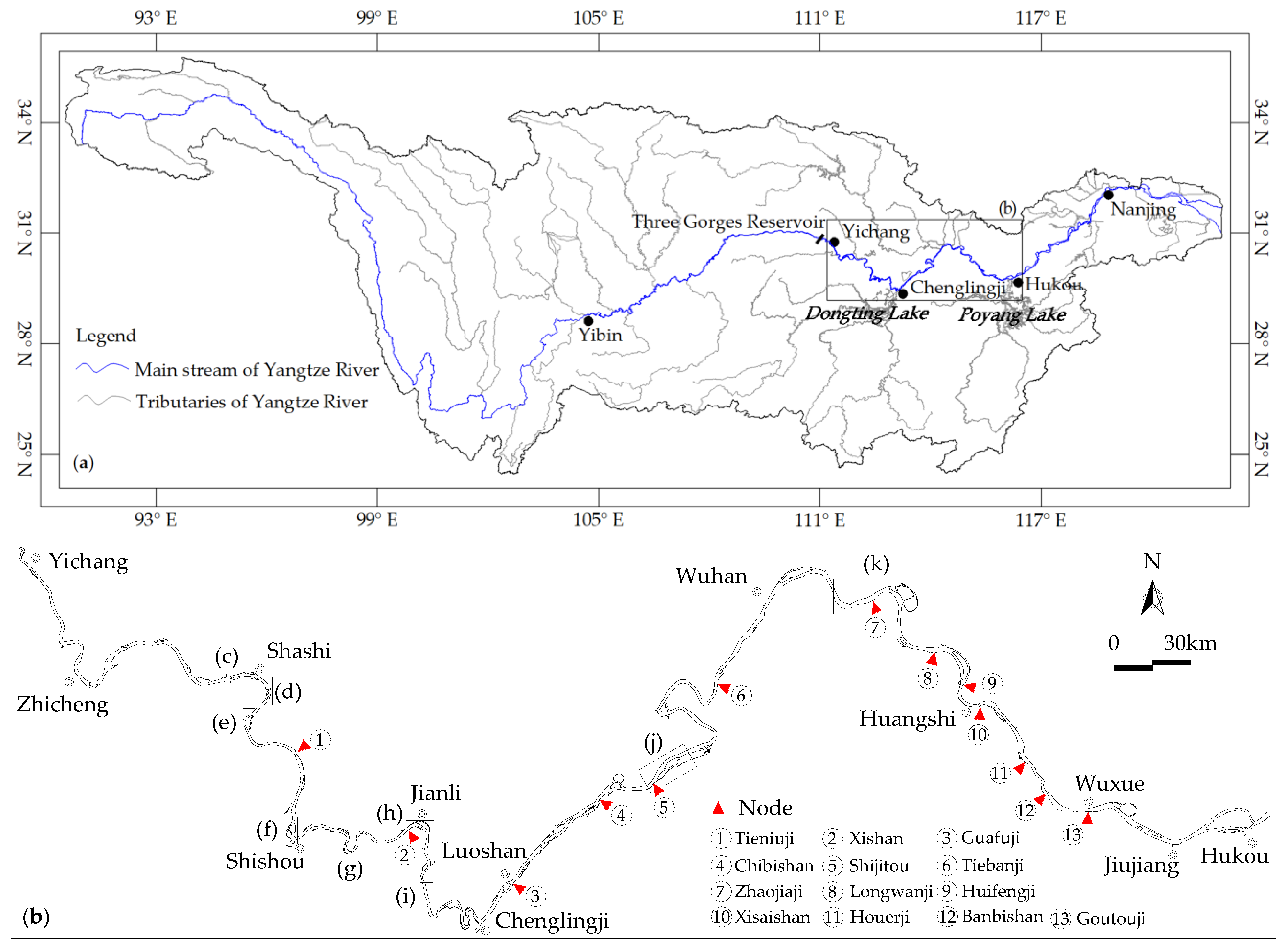
2.1. Study Area

The middle Yangtze River (Yichang to Hukou) is approximately 955 km long and has a relatively large river width, generally greater than 2000 m (Figure 1). Many control nodes in the river regime are unevenly distributed on both banks of this reach. The existence of these control nodes causes the entire river plane to take on the appearance of a lotus. Some well-known nodes are shown in Figure 1b. There are many types of channels in the study area, including straight, branching, and meandering channels. In these reaches, when the upstream inflow conditions change, the main flow migrates from one side to another, from one branch to another, or from the curved to the straight side. Typical river sections with nodes selected from the focal study area are shown in Figure 1c–k. The Taipingkou reach is a typical straight river section (Figure 1c) with a middle bar distributed throughout the relaxed section. The Wakouzi (Figure 1d), Majiazui (Figure 1e), Ouchikou (Figure 1f), Jianli (Figure 1h), Jiayu (Figure 1j), and Huguang (Figure 1k) reaches comprise branching river sections divided into two or more branches by middle bars. Tiaoguan (Figure 1g) and Tiepu (Figure 1i) comprise meandering channels where the sidebars are located. The side or middle bars in these river sections are usually induced by changes in the river width.

2.2. Data

Topographic and hydrological survey data were used in this study. There are two types of topographic data: cross-sectional data expressed in the form of distance from the starting point (elevation) and plane data composed of the measured elevation points (the mapping scale is 1:10,000). These data were obtained primarily from the Bureau of Hydrology of the Changjiang Water Resources Commission.
The hydrological survey data included the water level, flow discharge, and vertical averaged velocity, mainly from the Changjiang Waterway Institute of Planning and Design. Before the hydrometric measurements, cross-sectional topography measurements were conducted, based on which vertical lines were laid out. The number of vertical lines is determined based on the width of the water surface. Below 500 m, 4–5 vertical lines were established; they were increased to 5–10 when the river width was between 500–1000 m. Above 1000 m, 10–15 vertical lines were established. The flow velocity was measured using an acoustic Doppler current profiler (ADCP), according to previously described specifications [46].
The details of each type of data are shown in Table 1.

2.3. Methods

To analyse the main controlling factors affecting the main flow migration, this study defined coefficients to establish the correlation between the main flow migration characteristics and controlling factors.

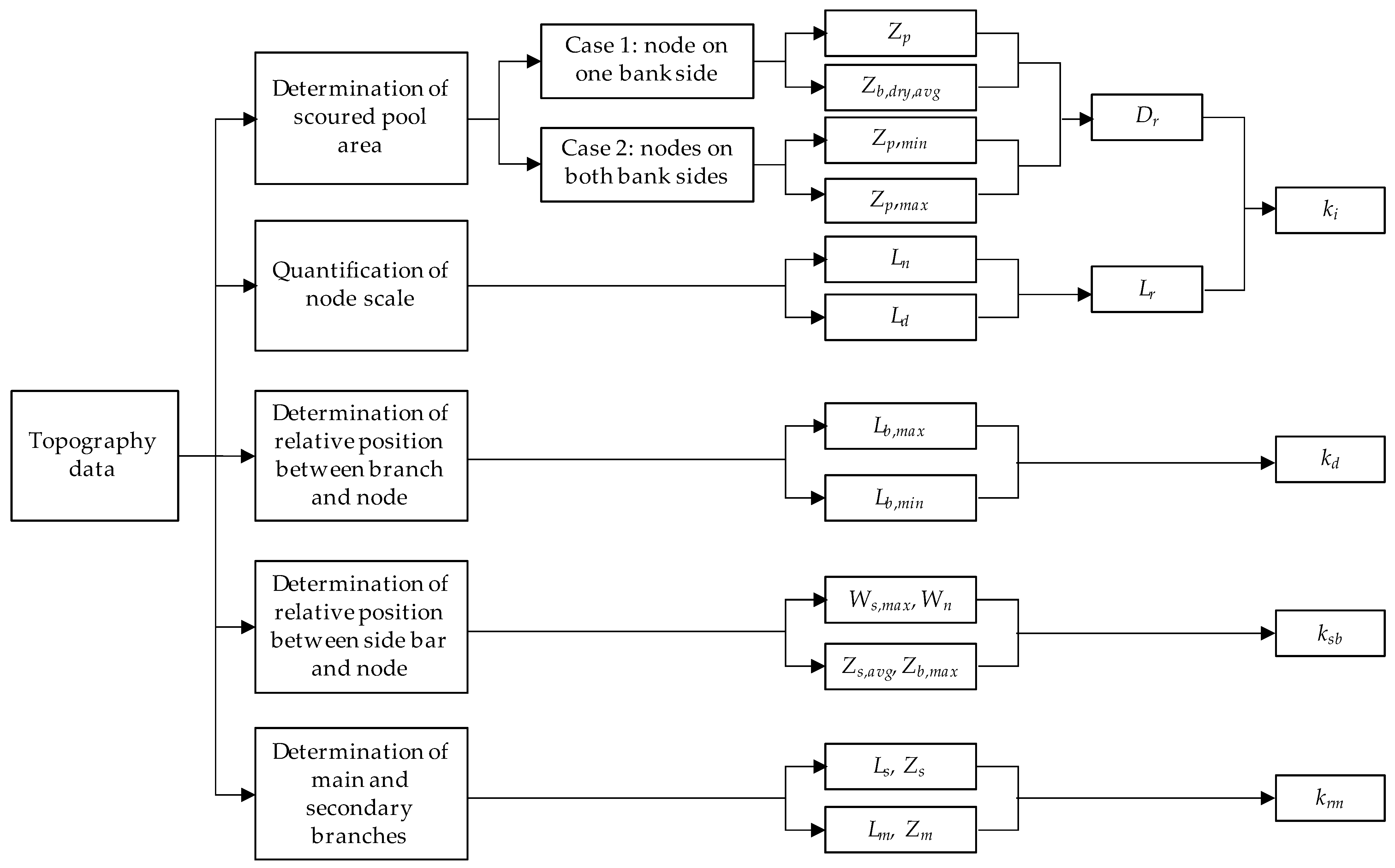
2.3.1. Influence Coefficient

Nodes generally consist of rocky or alluvial deposits or artificial revetments on both banks that do not erode easily and have a significant moderating effect on river regime changes in wandering rivers [47]. The strength of its action on the flow can be measured by the width-to-depth ratio of the cross-section, length, and scouring resistance of the riverbank composition [48]. Generally, scoured pools exist near nodes that cannot be scoured on the banks, the depth of which reflects the control effect of the nodes on the main flow. This study defines two methods for calculating the relative depth (Dr) of scoured pools. For a node on only one bank, Dr is defined as
Dr = Zp/Zb,dry,avg
where Zp is the depth of the scoured pool and Zb,dry,avg is the average riverbed elevation under dry low-flow conditions.
For the nodes on both banks, Dr is defined as follows:
Dr = Zp,min/Zp,max
where Zp,min and Zp,max are the smallest and largest depths of the scoured pools near the two nodes, respectively.
The larger the Dr, the stronger the deflecting action of the node. In addition, the strength of the node-deflection effect and its impact on the downstream river regime are separate concepts. The latter should also consider the node length (Ln) and distance (Ld) from the node to the downstream diversion point of the branching rivers. Ln refers to the projection length of the node in the direction of water flow during the middle water flow period. For a straight river, Ld is the distance from the node to the section with the largest width. This study defines the relative length (Lr) to reflect the magnitude of this impact.
Lr = Ln/Ld
Therefore, the influence coefficient (ki) of the node is defined as follows:
ki = Dr × Lr
In Equation (4), the first term is the relative depth of the node, which reflects its absolute deflection effect. The second term refers to the relative length of the node. The combination of these two factors reflects the impact of a node on the river regime.

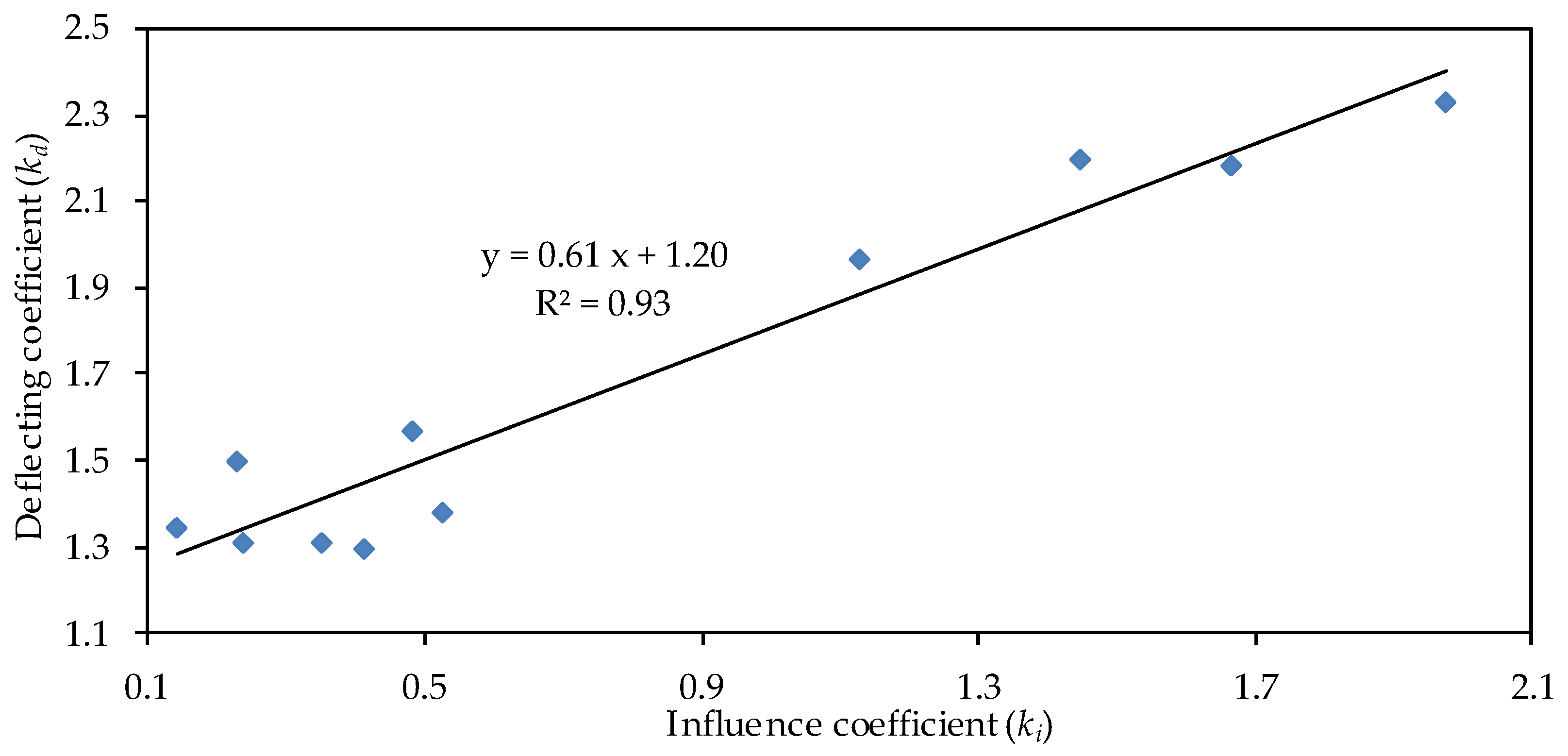
2.3.2. Deflecting Coefficient

The bifurcation coefficient of a branching river is the ratio of the total length of all branches to the length of the main branch [49]. The larger the value, the more branched the river section, and the more dispersed the flow. Similarly, the longer the length of the branch influenced by the node, the stronger the deflection effect of the node. The deflection coefficient (kd) in this study was defined as follows:
kd = Lb,max/Lb,min
In Equation (5), Lb,max is the maximum length of the branch on the deflecting side, and Lb,min is the minimum length of the branch on the non-deflecting side.
Node deflection is closely related to the development of a branched river. At the beginning of formation, the main characteristic of a branching river is the continuous bending and development of the branch, influenced by the deflection action of the node; that is, kd increases.

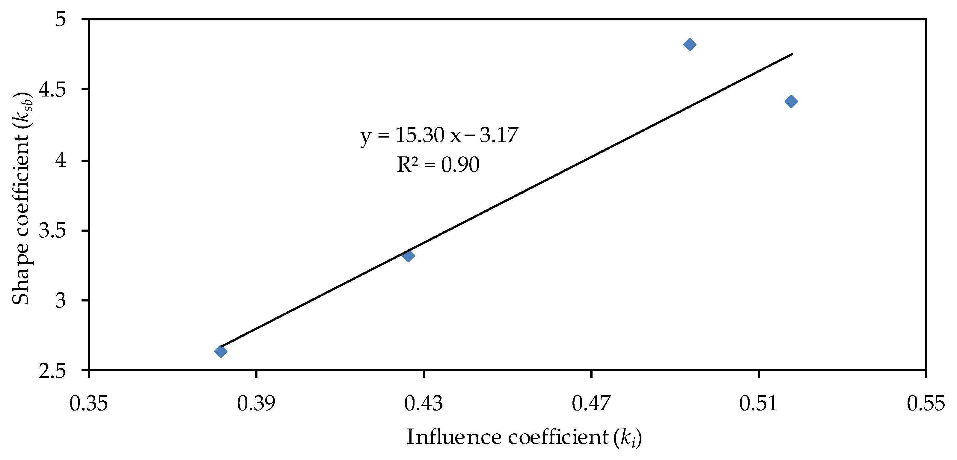
2.3.3. Shape Coefficient

The main parameters that characterize the planar morphological characteristics of the side bar include the perimeter, area, length, and width [50]. In this study, the shape coefficient of the sidebar (ksb) was defined as follows:
Ksb = (Ws,max/Wn) × (Zs,avg/Zb,max)
where Ws,max is the maximum width of the sidebar, Wn is the width at which a node is located, Zs,avg is the average elevation of the sidebar, and Zb,max is the average elevation of the riverbed where the sidebar is located. The ratio of the two reflects the scale of the sidebar in terms of the riverbed morphology.

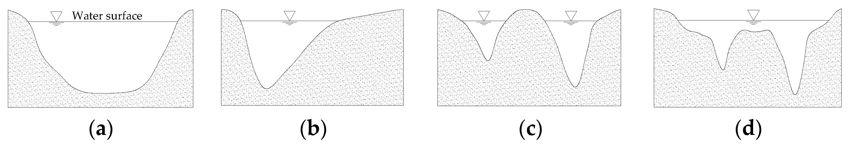
2.3.4. Riverbed Morphology Coefficient

According to Manning’s formula [51,52], the velocity ratios of the main and secondary branches can be expressed as follows:
Vm/Vs = (ns/nm) × (Hm/Hs)2/3 × (Jm/Js)1/2
where V is the flow velocity, n is the roughness, H is the water depth, J is the water surface gradient, and m and s represent the main and secondary branches, respectively. The variation range of the roughness in the main and secondary branches is usually small [48], that ns, nm ≈ 1. The water surface gradient can be expressed as:
J = ∆WS/L
Because the water surface of the main and secondary branches at the diversion and confluence points are the same, the water level difference (∆WS) will also be the same in both branches. Then, (Jm/Js) is:
Jm/Js = LS/Lm
Water depth H can be expressed as the difference between the average water surface (WS) and riverbed elevation Z (Hm/Hs):
Hm/Hs = (WSZm)/(WSZs)
By combining Formulas (9) and (10), Formula (7) can be rewritten as:
Vm/Vs = [(WSZm)/(WSZs)]2/3 × (Ls/Lm)1/2
Formula (11) shows that the flow velocity constrained by the riverbed morphology decreased with an increase in the elevation and length of the branch. Considering this and to simplify the calculation, the riverbed morphology coefficient in this study is defined as follows:
krm = (Zs × Ls)/(Zm × Lm)
The larger the krm, the higher the riverbed elevation, the longer the distance in the secondary branch, the greater its resistance, and the less likely the main flow is to migrate from the main branch to the secondary branch.

2.3.5. Data Processing and Research Process

After defining the above coefficients, a process diagram was designed to conduct the analysis, as shown in Figure 2. Different coefficient values were obtained using this diagram. After establishing the correlation between various coefficients, the key factors controlling the main flow migration were analyzed.

3. Results

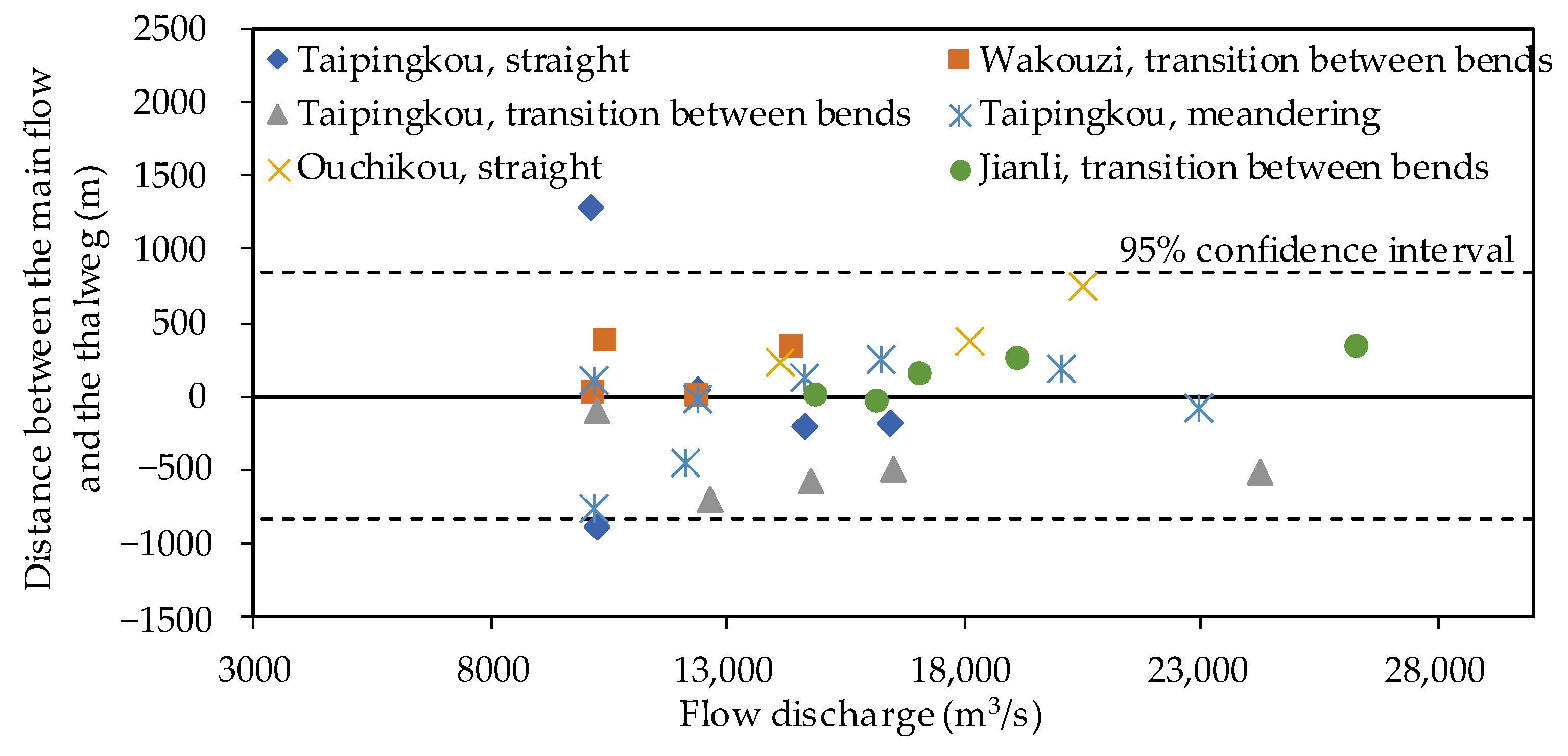
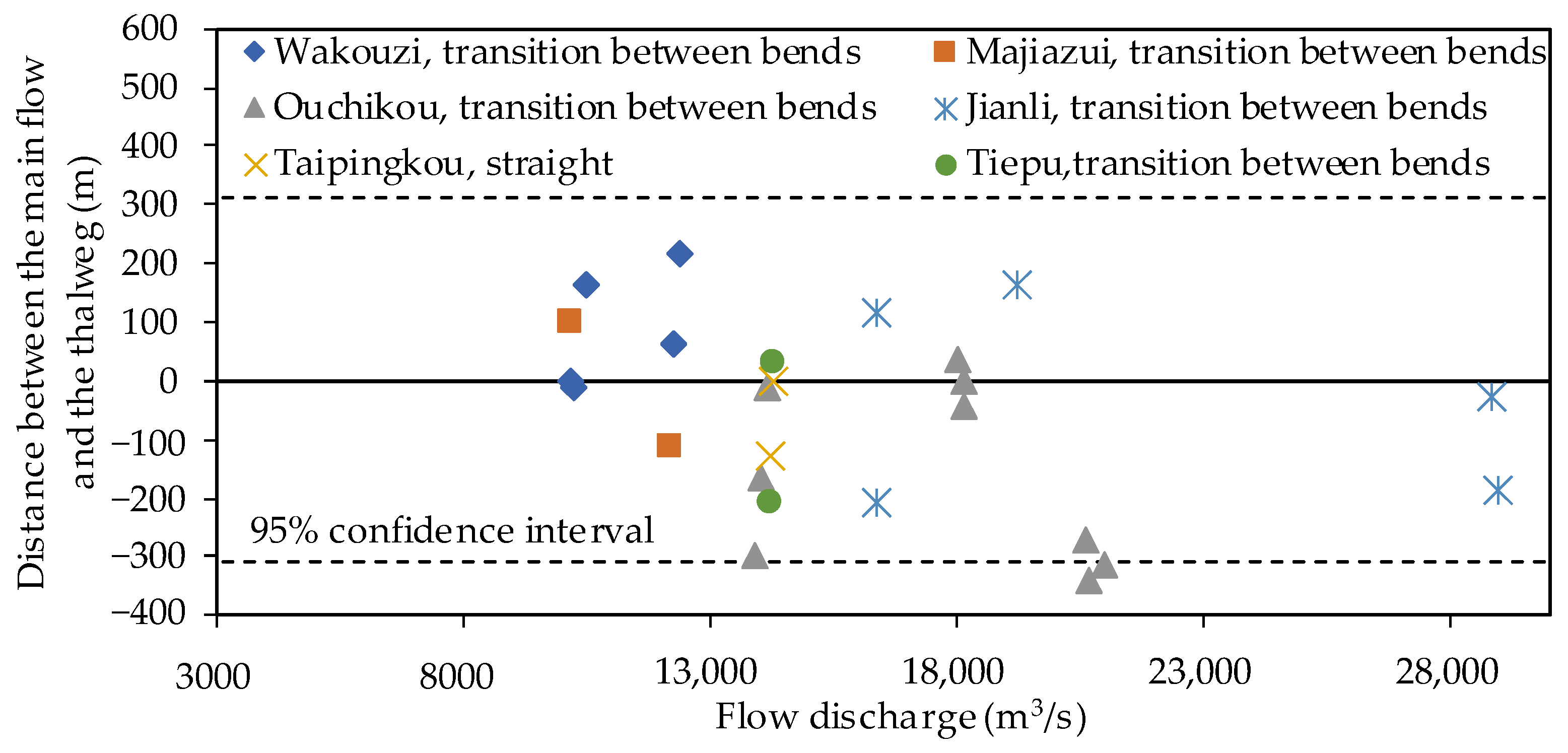
3.1. Characteristics of Main Flow Migration

As observed in the middle Yangtze River, the paths of the high, middle, and low flows were the same when the river width was small. In contrast, the river width of the middle Yangtze River is generally large, as mentioned above; therefore, the main flow and maximum flow velocity in most river sections oscillate with flow discharge. However, even in a reach where the main flow migration phenomenon was evident, the interannual position under the same flow discharge was generally relatively stable. During the dry season, this was consistent with the trend of pools or thalwegs, which are the deepest parts of the cross-sectional topography. During the flood season, the flow was straight and overflowed the sidebars. The migration of the main flow generally starts under a certain middle-flow discharge and gradually migrates away from the pools or thalwegs as the flow discharge increases. The main flow migration characteristics of the typical reaches of the middle Yangtze River during different periods of the year are as follows.

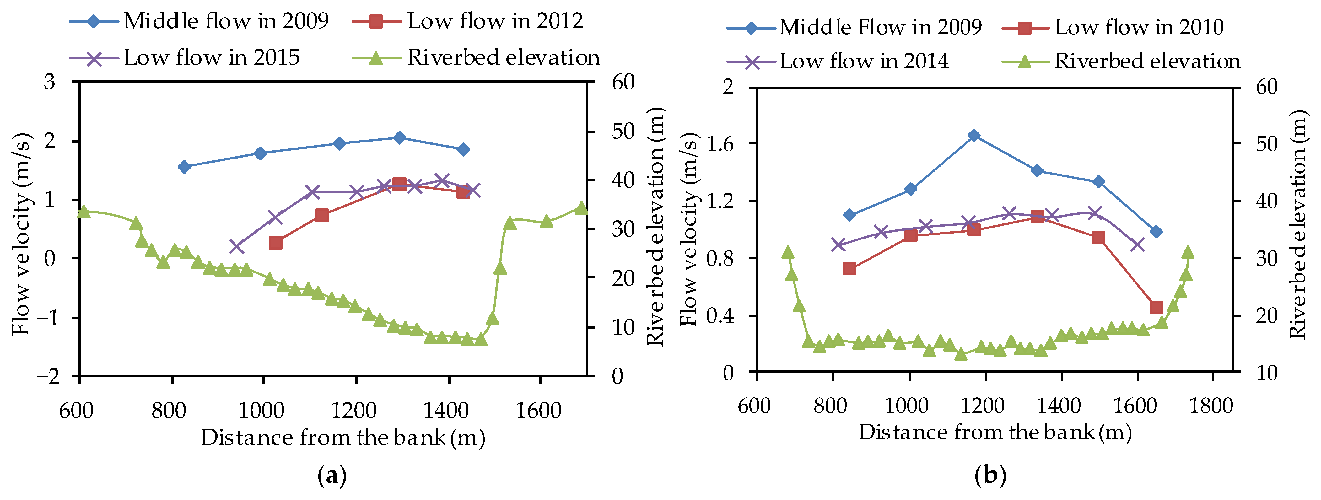
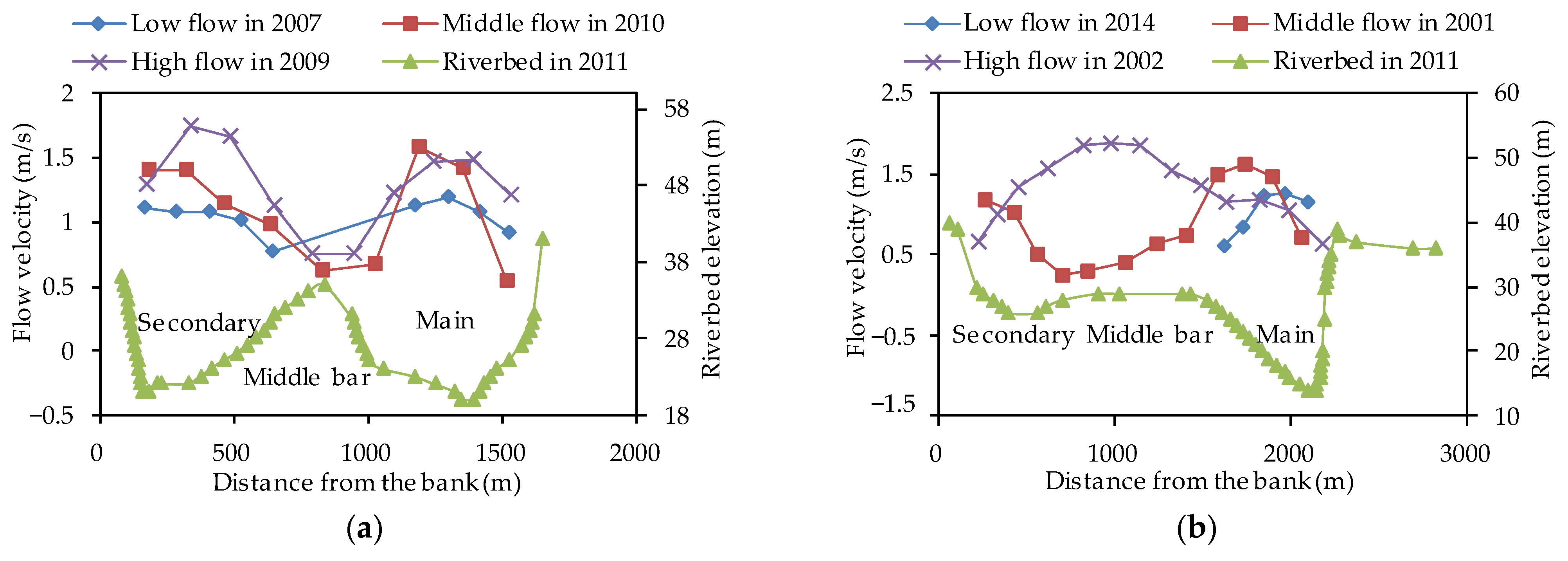
3.1.1. Low-Flow Period

During the low-flow period, which usually occurs in the dry season, the suction of pools across almost all types of rivers makes the main flow paths and thalwegs consistent with each other. Taking the Jingjiang reach (Zhicheng to Chenglingji) as an example, the distance between the main flow and the thalweg in the dry season usually varies within a small range, both in the wide-shallow and narrow-deep sections. A large amount of observational data from the Taipingkou, Wakouzi, Majiazui, Ouchikou, Jianli, Tiepu, and other river sections in the Jingjiang reach show that the distance between the main flow and the thalweg is more than 86% within 200 m and more than 75% within 150 m (Figure 3). The main flow is stable in the main channel during the dry season, which is consistent with the thalweg trend. Therefore, thalwegs are often used to represent the trend in the main flow of rivers during the dry season.

3.1.2. Middle-Flow Period

During the middle-flow period, the amplitude of the main flow migration in the wide-shallow and narrow-deep reaches began to differ. The cross-section of the wide-shallow reach usually has no obvious thalweg but a flat riverbed perpendicular to the direction of water flow, referred to as a “U” shape, as shown in Figure 4a. When there is an obvious thalweg in the section, it is termed a “V”-shaped section, as shown in Figure 4b. The “V”-shaped section often has steep bank slopes near the thalweg. When there are two thalwegs on the section, the shape of the section looks like a “W”, as shown in Figure 4c,d. In a “W”-shaped section, the riverbed elevation between two deep valleys is often higher.
For the wide-shallow sections, the main flow deviated from the thalweg (Figure 5), whereas for the narrow-deep sections, the main flow remained near the thalweg (Figure 6). In this period, when the river width is small or the section is of a “V” type, the amplitude of the main flow migration is limited, which is almost consistent with the main flow position during the low-flow period, that is, it is located in the main channel. For example, the positions of the main flow in the middle- and low-flow periods are almost identical in the Tiaoguan reach (Figure 7a). When the river width is large or the section is “U” or “W” shaped, the amplitude of the main flow migration increases significantly. Taking the “U”-shaped section in the Tiepu reach as an example, the thalweg or pool was not evident, and the position of the main flow in the middle- and low-flow periods was inconsistent (Figure 7b). The main reason for this phenomenon is that, with an increase in the flow discharge, the inertia of the flow increases and the restriction of the deep pool on the main flow is weakened. This is particularly true for sections where the thalweg is not obvious. The position of the main flow usually changes significantly during the middle-flow period, indicating an obvious migration of the main flow.

3.1.3. High-Flow Period

The main flow direction in the high-flow period was mainly affected by the plane shape and the deflection effect of nodes at the inlet. The main flow line of a meandering river in the middle Yangtze River generally deviates from the deep pool on the side of the concave bank to the middle and lower bars on the side of the convex bank with an increase in flow discharge. For a branching river, the main flow generally deviates from the main to the secondary branch at high water levels. This change in the main flow maintained the stability of the branching river and ensured that the secondary branch did not shrink. However, under special hydrological conditions, changes in the main flow cause alterations between the main and secondary branches. For example, in the straight section of the Taipingkou branching reach, the main flow is located in the main branch when the flow is small and starts to migrate to the secondary branch when the flow discharge gradually increases and exceeds 20,000 m3/s (Figure 8a). The main flow of the slightly curved branching section of the Majiazui reach also tended to migrate after the flow discharge exceeds 27,000 m3/s (Figure 8b). After the impoundment of the Three Gorges Reservoir, the splitting ratio of the secondary branches in the two reaches increased significantly. The main branch of the former finally shifted [53], and the latter did not result from the implementation of the restriction project in the secondary branch, which controlled a further increase in the splitting ratio.

3.2. Controlling Factors of Main Flow Migration

The flow momentum of the middle Yangtze River during the flood season was relatively large. For the reach with a relatively stable plane shape, the position of the main flow during the high-flow period showed little change between the years. In the low-flow season, the flow momentum is small and subjected to the riverbed shape, and the main flow path and channel pool or thalweg trends are consistent with each other. Therefore, the main flow migration in the middle Yangtze River was essentially a change in the main flow position during the middle-flow period. Compared with the high- and low-flow periods, the factors controlling the main flow migration during the middle-flow period are more complex, mainly including nodes and sidebars with a controlling function at the inlet, the plane shape of the river, and riverbed morphology.

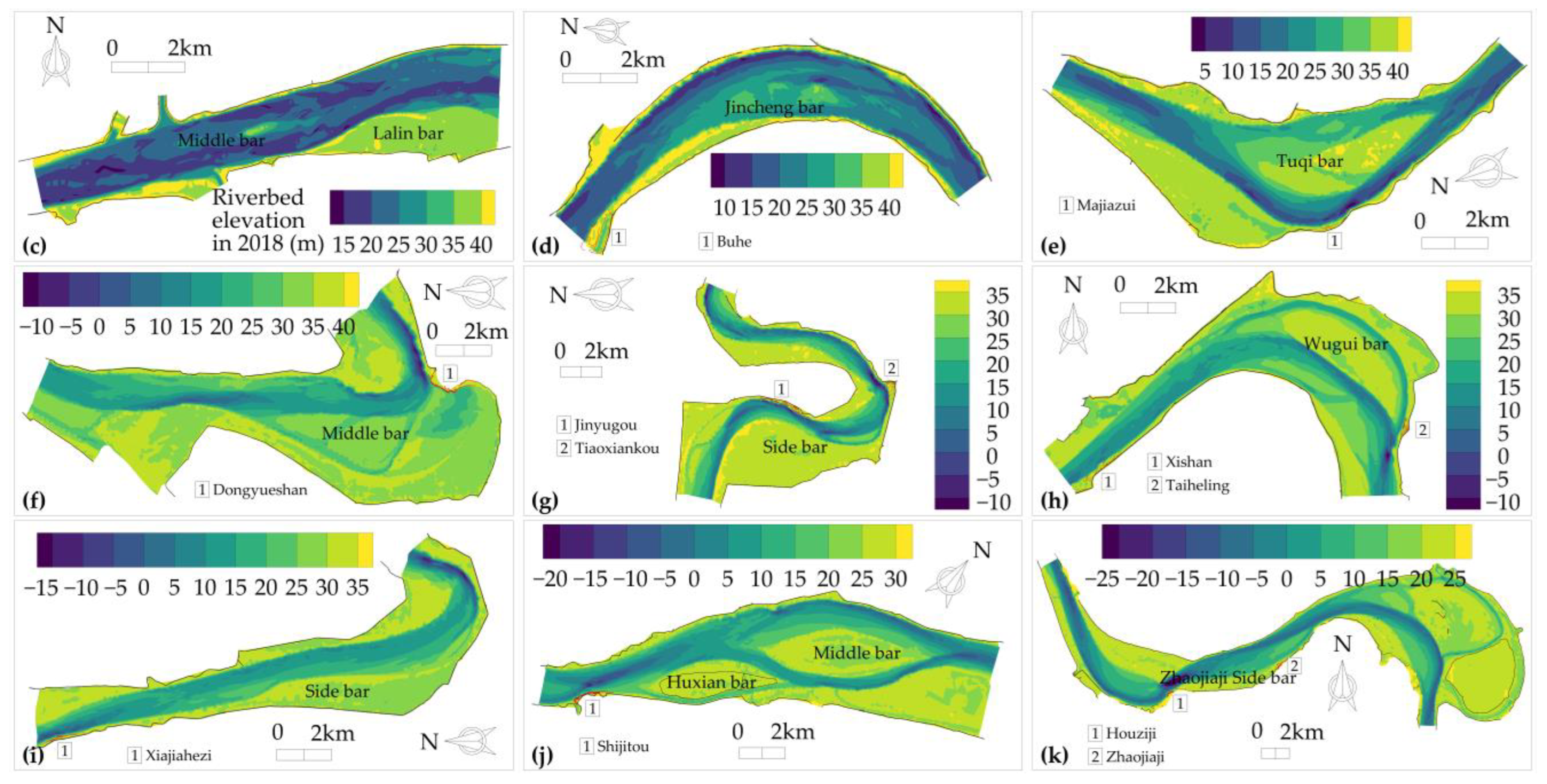
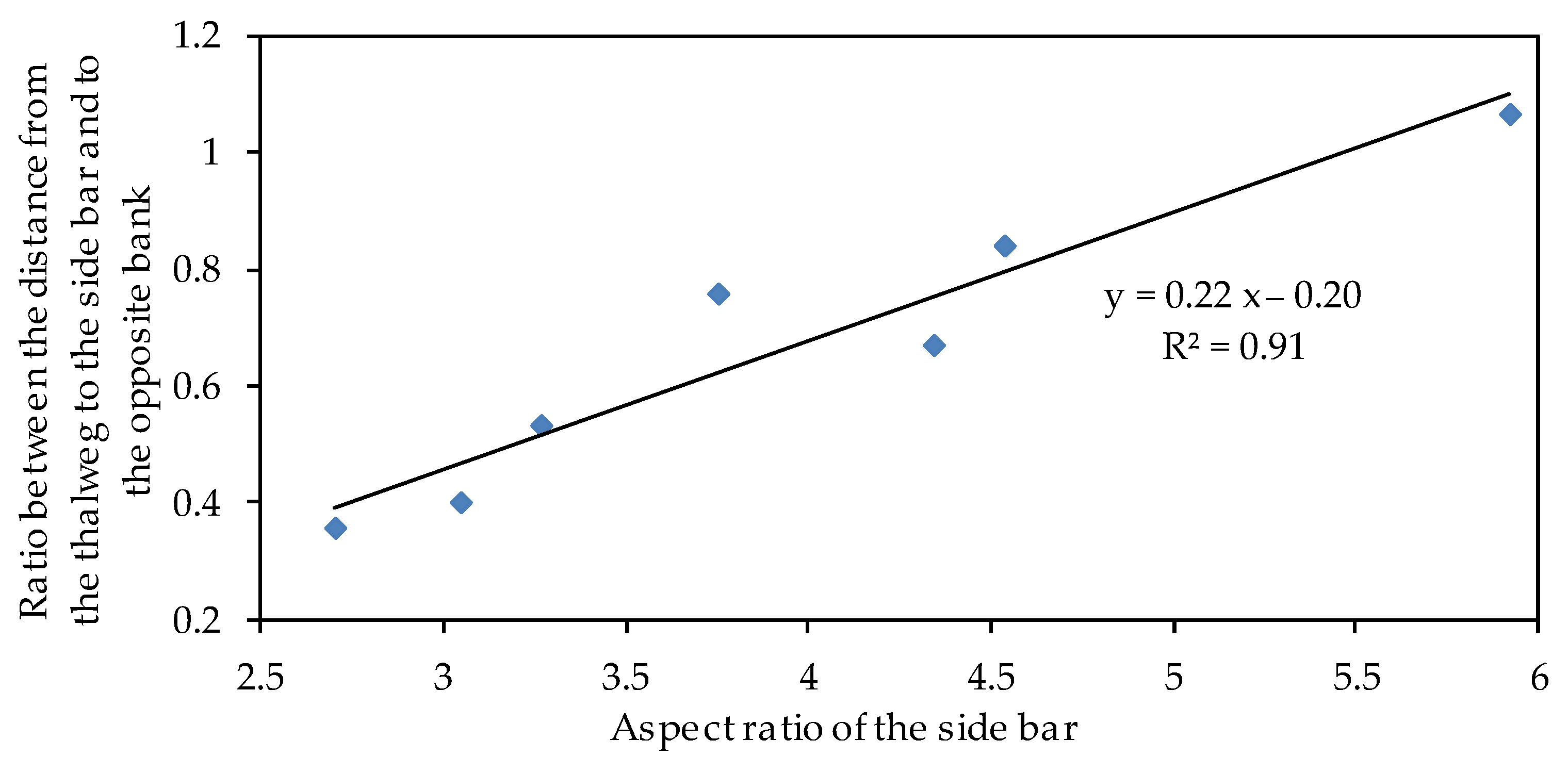
3.2.1. Nodes and Bars at the Inlet

If there are nodes on one or both bank sides at the inlet of a reach, or if there is a sidebar with a controlling function, it will lead to a sudden increase or decrease in the deflecting or diversion effect under a certain flow discharge [3], thereby changing the direction of the main flow at the inlet.
Figure 9 shows the relationship between the influence coefficient (ki) and deflection coefficient (kd) of the nodes in the branching rivers. A clear linear correlation is observed between the two coefficients (R2 = 0.93). The larger the influence coefficient, the larger the deflection coefficient, indicating a stronger impact on the branch into which the deflected water flows. This enhances the effect of the main flow migration.
Although many of the reaches downstream of the controlling nodes with strong deflecting actions did not form a branching river, they still exhibited some obvious characteristics. First, the channel relaxed; however, the degree of relaxation was lower than that of the branching channel. Second, there are generally relatively stable sidebars on the same bank of the node in the downstream reach, such as the Huxian sidebar downstream of the Shijitou node in the Jiayu reach (Figure 1j), the sidebar downstream of the Zhaojiaji node in the Huguang reach (Figure 1k), and the bar beside the right bank downstream of the Xisaishan node. Both these characteristics are related to the deflection actions of the nodes.
First, the shoreline of the downstream bank influenced by the deflecting action collapses and the river course widens; second, after the water flow is carried to the opposite bank, the downstream riverbank on the same side as the node is located in the slow flow area, and the sediment is easily deposited. A sidebar is formed after a certain period. For a channel with a stable node, the sidebar scale is relatively stable. Therefore, the deflection of the node can be considered to be related to the river width and scale of the sidebar downstream of the node (represented by the shape coefficient ksb). Figure 10 shows the relationship between ki and ksb. From this, it can be seen that the two coefficients are positively correlated; that is, the stronger the deflecting effect of the node, the greater the widening degree of the downstream channel and the size of the sidebar on the same bank.
The deflecting action on the main flow migration was related to the shape of the sidebar body. The greater the width of the body perpendicular to the flow direction, the stronger the deflecting action on the main flow, and the greater the migration degree of the main flow, indicating that a thalweg is more inclined to be situated on the opposite side of the sidebar body. When the width was overdeveloped, it was easily cut, after which the main flow migrated from one side to the other. Figure 11 shows the relationship between the relative position of the thalweg (ratio of the distance from the thalweg to the sidebar and the opposite bank) and the relative length of the sidebar (aspect ratio). There is good correspondence between the two. The shorter and wider the sidebar shape, the farther the thalweg was from the bar, and the closer the main flow was to the opposite bank. The longer and narrower the shape, the closer the thalweg was to the bar.

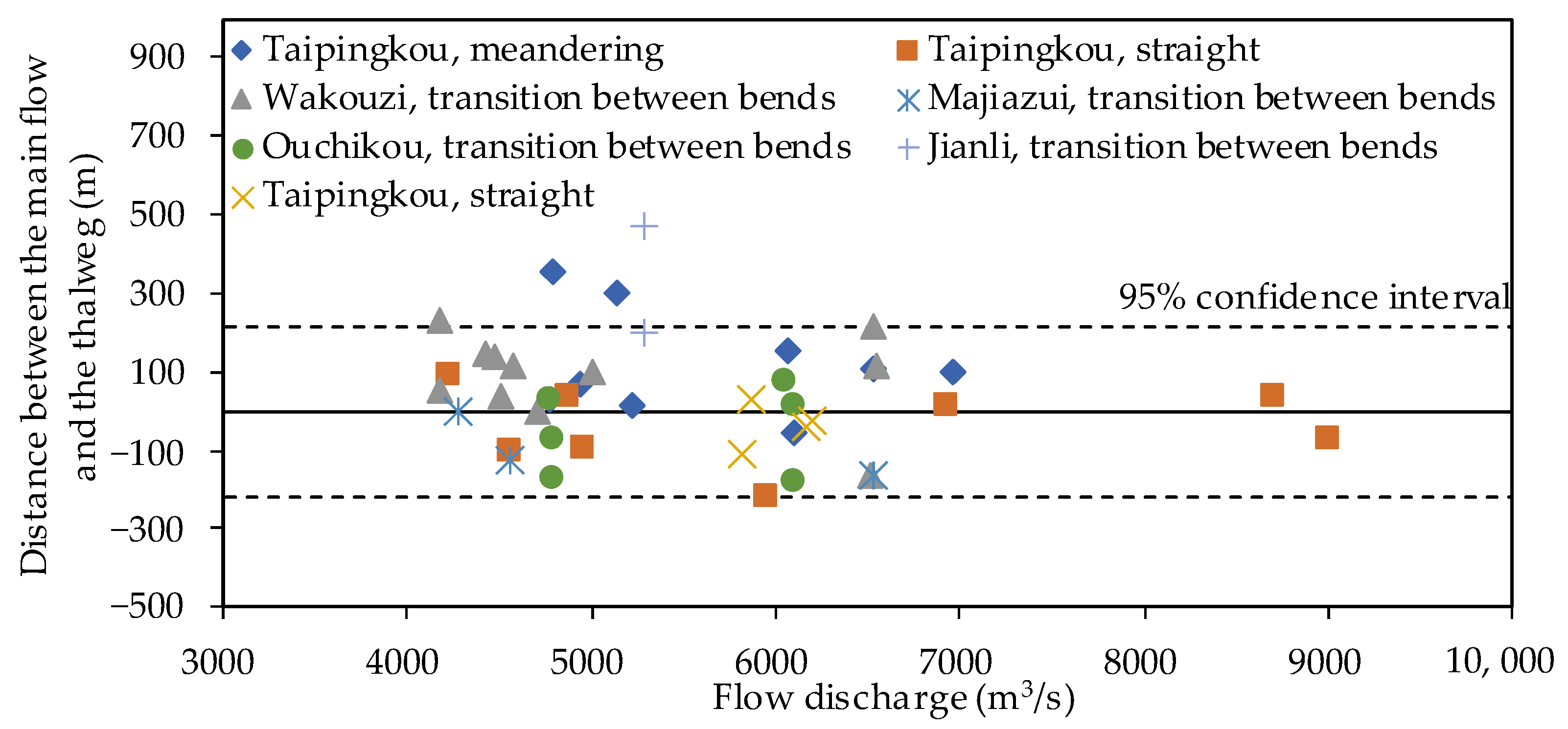
3.2.2. Plane Shape of the River

The impact of the plane shape of the river was most intuitive in curved and relaxed river sections. The relaxation of the river channel provides space for the migration of the main flow, which causes the flow in the bend reach to follow the law of “taking straight during high flow and turning with small flow”.
In general, the change in the plane shape of a river channel is explained by the rate of change in the river width and curvature. As mentioned previously, the migration of the main flow has certain requirements for the channel width. This occurred only when the channel width reached a certain threshold. The greater the degree of relaxation, the more evident the amplitude and frequency of the main flow migration. Therefore, channel relaxation is a prerequisite for the main flow migration.
River curvature is another factor that affects main flow migration. In a tank experiment, it was found that the velocity in a rectangular channel was uniformly distributed, whereas the longitudinal velocity in the curve was often different for the concave and convex banks [48]. In the meandering reaches of the middle Yangtze River, when the controlling function of the upstream regime is weak or the transition section between the bends is long, the phenomenon of leaning towards the convex bank in high flow and moving towards the concave bank in low flow becomes more obvious. Therefore, the migration of the main flow in the curved river section can also be considered a change in the bending radius of the hydrodynamic axis [53]. This is restricted by the bend shape (including the bend radius and section width-to-depth ratio). Conversely, it is related to the flow momentum. If the momentum is large, the inertial effect and the ability to overcome the constraints of the river bend are strong, and the main flow is easier to straighten. By contrast, it is easy to take turns.
Figure 12 shows the relationship between the bending radius of the hydrodynamic axis and the flow discharge with different river regime control functions in the reaches of Jianli and Shashi. The Jianli reach has a longer transition section with a stronger upstream control effect and a larger curvature. The bending characteristics in the Jianli reach are more evident. With the increase in the flow discharge in the middle- and low-flow seasons, the changing range and speed of the bending radius of the main flow line were small. When the flow rate was increased further, the latter characteristics increased significantly. This also shows that the position of the main flow in the dry season is relatively stable and that the large migration of the main flow should begin at a larger flow discharge.

3.2.3. Riverbed Morphology

Subject to the riverbed morphology, the resistance of different branches in the branching reach is often different. For a long-term stable branching reach, the resistance of the secondary branch is generally greater than that of the main branch. With an increase in the flow discharge, the ability of the flow to overcome the resistance of the riverbed becomes increasingly stronger, leading to a larger diversion ratio for the secondary branch, as shown in Figure 13. Consequently, the main flow may have migrated from the main branch to the secondary branch.
The riverbed morphology coefficients (krm) of the three branching reaches of the Jingjiang Reach (Shashi, Wakouzi, and Majiazui) are listed in Table 2. It can be observed that the largest is in the Shashi reach, where the main flow migration is the most prominent. This indicated that the main flow migration in the branching reach was related to the morphology of the riverbed. The higher the elevation and the longer the branch reach, the more stable the main flow, indicating a lower probability of main flow migration.
Analogous to a single river section, meandering or straight, the influence of riverbed morphology on the main flow migration is mainly reflected by the elevation difference between the bars and pools. The length of the convex bank is smaller than that of the concave bank. Moreover, the elevation of the sidebar on the side of the convex bank was higher than that of the pool. Consequently, the main flow became more stable. For the straight reach, the lengths of both banks barely differed; however, the greater the ratio of the sidebar elevation to the pool, the more stable the main flow. Conversely, the main flow migrates easily.

4. Discussion

4.1. Main Findings, Comparison, and Limitations

Based on abundant hydrological and topographic observational data, this study analyzed the characteristics and controlling factors of the main flow migration in the middle Yangtze River after the impoundment of the Three Gorges Reservoir. We showed that the displacement of the main flow zone under middle-flow discharge characterises the main flow migration in the study area, the causes of which include the deflecting action of the node or bar at the inlet, relaxation of the river plane shape, and differences in the resistance effect owing to the riverbed morphology between the branches.
These results were consistent with those of previous studies. For example, some studies have suggested that bars are widespread in meandering rivers and play an important role in the formation of river patterns [54,55]. A study focusing on a large sand-bed braided river showed that changes in the riverbed morphology had a positive impact on the confluence [56]. For branching rivers, the resistance changes in the branches lead to the deflection of the main flow [57], and the ratio of the lengths of the two branches plays an important role in the transposition of the main branch [58]. In addition, valley width plays a key role in determining the degree of braiding, active channel width, and channel activity [59]. Compared to these previous studies, the present study focused more on the influence of the physical boundary of the river reach, which can enrich our understanding of the main flow migration mechanism. Combined with the comprehensive impact of water and sediment conditions and the physical boundaries of the river channel, it would be helpful to predict the trend of the main flow migration in the middle Yangtze River more accurately in the future.
Although this study collected a certain amount of topographic and hydrological survey data and established correlations between the key controlling factors of main flow migration, it is worth noting that the current data quantity remains at a certain distance from that required to obtain a more universal correlation. For large natural river channels, such as the Yangtze River, large-scale and high-frequency topographic and hydrological survey data observations require significant human, material, and financial resources. Therefore, further studies should be conducted using flume experiments. Flume experiments can provide diverse hydrological and river boundaries, and more universal and convincing results can be obtained by using more experimental data under multiple operating conditions.

4.2. Future Work and Policy Recommendation

As of 2020, 112 large reservoirs are operating on the Yangtze River and its tributaries, and another six large reservoirs are under construction or planned [60]. This implies that the middle Yangtze River will continue to face long-term changes in water and sediment conditions. First, the peak flow influenced by the operation of the cascade reservoirs was reduced, and the duration of the middle flow was extended [61], which led to more frequent main flow migration. Second, after the impoundment of the Three Gorges Reservoir, the river channel, whether a deep pool or low sand bar, was in a state of scouring [62]. The deflecting action of the nodes is enhanced, and on the other hand, the low sand bar scouring causes the middle flow channel to be further widened, both of which will ease main flow migration. Although the plane shape is subjected to revetment work, bank collapse in the middle of the Yangtze River has occasionally occurred in recent years [63], and secondary branch erosion has developed in some branching rivers [64,65]. Therefore, under the conditions of cascade reservoir operation in the future, both the water and sediment conditions and the physical boundary of the river channel may further promote the main flow migration in the Yangtze River.
The impact of main flow migration on the ecological environment is not only reflected in the changes in the habitat characteristics of aquatic organisms, such as water flow, nutrients, temperature, and substrate, but also in the changes in mating, breeding, growth, and other processes. In addition, as a continuous water body, the change in the river network composed of branches owing to the main flow migration also has an impact on the diversity of aquatic organisms [66]. Therefore, the impact of the development trend of main flow migration on the aquatic ecological environment is noteworthy. Research has shown that the bending of a river can enhance the persistence of species [67], but a naturally continuously bent river cannot provide a stable living environment for fish [68]. Highly branched rivers have high habitat heterogeneity [69], and fish must choose their route at each junction in the branch during diffusion or movement [70]. Therefore, more frequent main flow migration in the middle Yangtze River in the future is bound to pose a threat to the living environments of aquatic organisms. Consequently, by integrating the future water and sediment conditions and river boundary changes that drive the main flow migration, it is recommended that appropriate governance measures be developed to stabilize the main flow path during middle-flow discharge to avoid ecological disasters after the operation of the cascade reservoirs.

5. Conclusions

This study aimed to reveal the characteristics and key factors controlling the migration of the main flow in the middle Yangtze River. Based on topographic and hydrological survey data, this study analyzed the characteristics of main flow migration under different hydrological conditions and established correlations between its key controlling factors. The results indicated that the main flow was almost consistent with that of the deep pool under low-flow discharge and tended to be straight during the high-flow period. This is further characterized by the displacement of the main flow zone under a middle-flow discharge.
During the middle-flow period, the main flow migration is mainly affected by three factors: the deflecting action of the node or sand bar with controllable conductivity at the inlet, which changes the main flow direction; the relaxed plane shape of the river channel which, provides space for migration; and the resistance difference caused by the riverbed morphology between the branches which, drives the transposition of the main and secondary branches.
Under the influence of the operation of cascade reservoirs in the future, the flow process in the middle Yangtze River will be further flattened and the duration of the middle flow will be extended. The results of this study imply that the migration of the main flow is further promoted, thereby affecting the aquatic ecological environment. Governance measures for stabilising the main flow should be implemented to avoid ecological disasters in combination with changes in water, sediment, and river boundary conditions.
Compared with the current research, which focuses more on the influence of water and sediment conditions, this study supplements the influence of the physical boundary conditions of river channels on main flow migration. For further research, flume experiments should be conducted to obtain more data under various hydrological and physical river boundary conditions.

Author Contributions

Conceptualisation, H.G. and L.Z.; methodology, L.Z.; formal analysis, H.G. and L.Z.; investigation, H.G.; resources, L.Z.; data curation, L.Z.; writing—original draft preparation, H.G.; writing—review and editing, L.Z.; visualisation, H.G.; supervision, H.G.; project administration, H.G.; funding acquisition, H.G. All authors have read and agreed to the published version of the manuscript.

Funding

This research was funded by the National Science and Technology Support Program (grant number 2022YFC3202602), the Major Science and Technology Projects of the Ministry of Water Resources of China (grant number SKR-2022009), the National Natural Science Foundation of China (grant numbers U2240206 and U2240224), and the Overall Planning Project for Succeeding Work of the Three Gorges Project (grant number CKSG2021257/HL).

Data Availability Statement

Not applicable.

Acknowledgments

This study was supported by the research and innovation team responsible for river and lake protection and regulation in the middle and lower reaches of the Yangtze River, led by Shiming Yao.

Conflicts of Interest

The authors declare no conflict of interest.

References

  1. Yu, Y.; Xia, J.; Li, J.; Zhang, X. Influences of the Xiaolangdi Reservoir on the channel geometry and flow capacity of wandering reach in the Lower Yellow River. J. Sediment Res. 2020, 45, 7–15. [Google Scholar] [CrossRef]
  2. Hu, W. Bank collapse and its Prevention in the Main Stream of the Middle and Lower Reaches of the Yangtze River. Technol. Econ. Chang. 2020, 4, 17–20. [Google Scholar] [CrossRef]
  3. Zhu, L.; Chen, D.; Ge, H. Study of effect of mainstream swing in middle Yangtze River. J. Sediment Res. 2014, 21–26. [Google Scholar] [CrossRef]
  4. Xu, J.X. Channel pattern change downstream from a reservoir: An example of wandering braided rivers. Geomorphology 1996, 15, 147–158. [Google Scholar] [CrossRef]
  5. Zhang, J.H.; Sun, M.K.; Deng, Z.M.; Lu, J.; Wang, D.W.; Chen, L.; Liu, X.Y. Runoff and Sediment Response to Cascade Hydropower Exploitation in the Middle and Lower Han River, China. Math. Probl. Eng. 2017, 2017, 1–15. [Google Scholar] [CrossRef]
  6. Xu, J.X. Evolution of mid-channel bars in a braided river and complex response to reservoir construction: An example from the middle Hanjiang River, China. Math. Probl. Eng. 1997, 22, 953–965. Available online: https://onlinelibrary.wiley.com/doi/abs/10.1002/%28SICI%291096-9837%28199710%2922%3A10%3C953%3A%3AAID-ESP789%3E3.0.CO%3B2-S (accessed on 17 April 2023).
  7. Yao, S.; Qu, G.; Wang, H. Braided channel evolution in the middle and lower reaches of the Yangtze River after operation of the Three Gorgers Reservoir. In Proceedings of the 13th International Symposium on River Sedimentation (ISRS), Stuttgart, Germany, 19–22 September 2016; p. 162. [Google Scholar]
  8. Han, J.Q.; Zhang, W.; Fan, Y.Y.; Yu, M.Q. Interacting effects of multiple factors on the morphological evolution of the meandering reaches downstream the Three Gorges Dam. J. Geogr. Sci. 2017, 27, 1268–1278. [Google Scholar] [CrossRef]
  9. Yang, Y.; Zhou, L.; Zhu, L.; Liu, W.; Wang, J. Impact of upstream reservoirs on geomorphic evolution in the middle and lower reaches of the Yangtze River. Earth Surf. Process. Landf. 2023, 48, 582–595. [Google Scholar] [CrossRef]
  10. Yang, Y.P.; Zheng, J.H.; Zhang, H.Q.; Chai, Y.F.; Zhu, Y.D.; Wang, C.Y. Impact of the Three Gorges Dam on riverbed scour and siltation of the middle reaches of the Yangtze River. Earth Surf. Process. Landf. 2022, 47, 1514–1531. [Google Scholar] [CrossRef]
  11. Wang, S.J.; Mei, Y.G. Lateral erosion/accretion area and shrinkage rate of the Linhe reach braided channel of the Yellow River between 1977 and 2014. Earth Surf. Process. Landf. 2016, 26, 1579–1592. [Google Scholar] [CrossRef]
  12. Wu, X.Y.; Li, Z.W.; Gao, P.; Huang, C.; Hu, T.S. Response of the Downstream Braided Channel to Zhikong Reservoir on Lhasa River. Water 2018, 10, 18. [Google Scholar] [CrossRef]
  13. Wang, Y.; Xia, J.; Zhou, M.; Li, J. Characteristics of main channel migration in the braided reach of the Lower Yellow River after the Xiaolangdi Reservoir operation. Adv. Water Sci. 2019, 30, 198–209. [Google Scholar] [CrossRef]
  14. Li, J.; Xia, J.Q.; Ji, Q.F. Rapid and long-distance channel incision in the Lower Yellow River owing to upstream damming. Catena 2021, 196, 10. [Google Scholar] [CrossRef]
  15. Xia, J.Q.; Wang, Y.Z.; Zhou, M.R.; Deng, S.S.; Li, Z.W.; Wang, Z.H. Variations in Channel Centerline Migration Rate and Intensity of a Braided Reach in the Lower Yellow River. Remote Sens. 2021, 13, 21. [Google Scholar] [CrossRef]
  16. Xia, J.Q.; Li, J.; Carling, P.A.; Zhou, M.R.; Zhang, X.L. Dynamic adjustments in bankfull width of a braided reach. Proc. Inst. Civil. Eng.-Water Manag. 2019, 172, 207–216. [Google Scholar] [CrossRef]
  17. Li, D. River regime evolution and protection scheme at the left branch of Xiaohuangzhou in the Maanshan reach of the Yangtze River. Water Resour. Plan. Des. 2020, 28–32. [Google Scholar] [CrossRef]
  18. Yan, H.C.; Zhang, X.F.; Xu, Q.X. Variation of runoff and sediment inflows to the Three Gorges Reservoir: Impact of upstream cascade reservoirs. J. Hydrol. 2021, 603, 13. [Google Scholar] [CrossRef]
  19. Belletti, B.; Dufour, S.; Piégay, H. What is the Relative Effect of Space and Time to Explain the Braided River Width and Island Patterns at a Regional Scale? River Res. Appl. 2015, 31, 1–15. [Google Scholar] [CrossRef]
  20. Li, X.J.; Xia, J.Q.; Li, J.; Zhou, M.R. Adjustments in reach-scale bankfull geometry of a braided reach undergoing contrasting channel evolution processes. Arab. J. Geosci. 2019, 12, 13. [Google Scholar] [CrossRef]
  21. Williams, R.D.; Brasington, J.; Hicks, D.M. Numerical Modelling of Braided River Morphodynamics: Review and Future Challenges. Geogr. Compass 2016, 10, 102–127. [Google Scholar] [CrossRef]
  22. Schuurman, F.; Ta, W.Q.; Post, S.; Sokolewicz, M.; Busnelli, M.; Kleinhans, M. Response of braiding channel morphodynamics to peak discharge changes in the Upper Yellow River. Earth Surf. Process. Landf. 2018, 43, 1648–1662. [Google Scholar] [CrossRef]
  23. Colombini, M.; Seminara, G.; Tubino, M. Finite-amplitude alternate bars. J. Fluid Mech. 1987, 181, 213–232. [Google Scholar] [CrossRef]
  24. Wu, F.; Yeh, T. Forced bars induced by variations of channel width: Implications for incipient bifurcation. J. Geophys. Res. Earth Surf. 2005, 110, F02009. [Google Scholar] [CrossRef]
  25. Kleinhans, M.G.; van den Berg, J.H. River channel and bar patterns explained and predicted by an empirical and a physics-based method. Earth Surf. Process. Landf. 2011, 36, 721–738. [Google Scholar] [CrossRef]
  26. Church, M. Bed Material Transport and the Morphology of Alluvial River Channels. Annu. Rev. Earth Planet. Sci. 2006, 34, 325–354. [Google Scholar] [CrossRef]
  27. Constantine, J.A.; Dunne, T.; Ahmed, J.; Legleiter, C.; Lazarus, E.D. Sediment supply as a driver of river meandering and floodplain evolution in the Amazon Basin. Nat. Geosci. 2014, 7, 899–903. [Google Scholar] [CrossRef]
  28. Zhao, Z.C.; Yao, S.M.; Jiang, E.H.; Qu, B. Experimental study and a physical model on the geomorphic response mechanisms of meandering rivers under progressive sediment reduction. Front. Earth Sci. 2022, 10, 22. [Google Scholar] [CrossRef]
  29. Li, J.; Xia, J.Q.; Zhou, M.R.; Deng, S.S.; Zhang, X.L. Variation in reach-scale thalweg-migration intensity in a braided reach of the lower Yellow River in 1986–2015. Earth Surf. Process. Landf. 2017, 42, 1952–1962. [Google Scholar] [CrossRef]
  30. Li, J.; Xia, J.; Deng, S.; Zhou, M.; Zhang, S. Characteristics of channel thalweg migration in the lower Yellow River over the past 30 years. Adv. Water Sci. 2017, 28, 652–661. [Google Scholar] [CrossRef]
  31. Wang, J.; Chen, B.; Duan, L.; Chen, T. Impacts of Xiaolangdi Reservoir on the Thalweg Evolution of the Lower Yellow River. Yellow River 2022, 44. 57-60+66. [Google Scholar]
  32. Inoue, T.; Mishra, J.; Kato, K.; Sumner, T.; Shimizu, Y. Supplied Sediment Tracking for Bridge Collapse with Large-Scale Channel Migration. Water 2020, 12, 1881. [Google Scholar] [CrossRef]
  33. Jing, H.; Zhong, D.; Zhang, H.; Wang, Y.; Huang, H. Riverbed adjustment characteristics in braided reaches of lower Yellow River under small and medium discharges. J. Hydroelectr. Eng. 2020, 39, 33–45. [Google Scholar] [CrossRef]
  34. Li, Z.W.; Yu, G.A.; Brierley, G.; Wang, Z.Y. Vegetative impacts upon bedload transport capacity and channel stability for differing alluvial planforms in the Yellow River source zone. Hydrol. Earth Syst. Sci. 2016, 20, 3013–3025. [Google Scholar] [CrossRef]
  35. Ielpi, A.; Lapotre, M.G.A.; Gibling, M.R.; Boyce, C.K. The impact of vegetation on meandering rivers. Nat. Rev. Earth Environ. 2022, 3, 165–178. [Google Scholar] [CrossRef]
  36. Zhu, L.K.; Chen, D.; Hassan, M.A.; Venditti, J.G. The Influence of Riparian Vegetation on the Sinuosity and Lateral Stability of Meandering Channels. Geophys. Res. Lett. 2022, 49, 10. [Google Scholar] [CrossRef]
  37. Schuurman, F.; Kleinhans, M.G.; Middelkoop, H. Network response to disturbances in large sand-bed braided rivers. Earth Surf. Dyn. 2016, 4, 25–45. [Google Scholar] [CrossRef]
  38. Witkowski, K. Man’s impact on the transformation of channel patterns (the Skawa River, southern Poland). River Res. Appl. 2021, 37, 150–162. [Google Scholar] [CrossRef]
  39. Konsuer, K.M.; Rhoads, B.L.; Langendoen, E.J.; Best, J.L.; Ursic, M.E.; Abad, J.D.; Garcia, M.H. Spatial variability in bank resistance to erosion on a large meandering, mixed bedrock-alluvial river. Geomorphology 2016, 252, 80–97. [Google Scholar] [CrossRef]
  40. da Silva, A.M.F.; Ebrahimi, M. Meandering Morphodynamics: Insights from Laboratory and Numerical Experiments and Beyond. J. Hydraul. Eng. 2017, 143, 03117005. [Google Scholar] [CrossRef]
  41. Parsapour-Moghaddam, P.; Rennie, C.D. Influence of Meander Confinement on Hydro-Morphodynamics of a Cohesive Meandering Channel. Water 2018, 10, 18. [Google Scholar] [CrossRef]
  42. Rashid, M.B.; Habib, M.A. Channel bar development, braiding and bankline migration of the Brahmaputra-Jamuna river, Bangladesh through RS and GIS techniques. Int. J. River Basin Manag. 2022, 20, 13. [Google Scholar] [CrossRef]
  43. Weiss, S.F.; Higdon, J.J.L. Dynamics of meandering rivers in finite-length channels: Linear theory. J. Fluid Mech. 2022, 938, 36. [Google Scholar] [CrossRef]
  44. Chen, X.B.; Wang, Y.C.; Ni, J.R. Structural characteristics of river networks and their relations to basin factors in the Yangtze and Yellow River basins. Sci. China-Technol. Sci. 2019, 62, 1885–1895. [Google Scholar] [CrossRef]
  45. Li, W.; Colombera, L.; Yue, D.L.; Mountney, N.P. Controls on the morphology of braided rivers and braid bars: An empirical characterization of numerical models. Sedimentology 2023, 70, 259–279. [Google Scholar] [CrossRef]
  46. China, M.o.W.R.o.t.P.s.R.o. Code for discharge measurement of acoustic Doppler current. 2006, SL 337-2006, 37–40. [Google Scholar]
  47. Qian, N. He Chuang Yan Bian Xue; Science Press: Beijing, China, 1987. [Google Scholar]
  48. Yu, W. Action of Nodes of the Braided Channel at the Lower Yangtze River in the Fluvial Processes. J. Sediment Res. 1987, 12–21. [Google Scholar] [CrossRef]
  49. Xie, J. River Bed Evolution and Regulation; China WaterPower Press: Beijing, China, 1997. [Google Scholar]
  50. Li, Z.; Wang, Z.; Zhang, K. Relationship between morphology of typical sand bars and river channels. J. Sediment Res. 2012, 68–73. [Google Scholar]
  51. Manning, R. ‘On the flow of water in open channels and pipes’ Transactions. Inst. Civ. Eng. Irel. 1891, 24, 179–207. [Google Scholar]
  52. Manning, R. Supplement to ‘On the flow of water in open channels and pipes’ Transactions. Inst. Civ. Eng. Irel. 1895, 24, 179–207. [Google Scholar]
  53. Zhu, L.; Zhang, W.; Ge, H. Evolution trend and causes of the typical braided middle Yangtze reach after Three Gorges reservior impoundment. J. Hydroelectr. Eng. 2011, 30, 106–113. [Google Scholar]
  54. Slowik, M. Sedimentary record of point bar formation in laterally migrating anabranching and single-channel meandering rivers (The Obra Valley, Poland). Z. Geomorphol. 2016, 60, 259–279. [Google Scholar] [CrossRef]
  55. Weisscher, S.A.H.; Shimizu, Y.; Kleinhans, M.G. Upstream perturbation and floodplain formation effects on chute-cutoff-dominated meandering river pattern and dynamics. Earth Surf. Process. Landf. 2019, 44, 2156–2169. [Google Scholar] [CrossRef] [PubMed]
  56. Yang, H.Y.; Cong, P.T. Confluence Dynamics in a Modelled Large Sand-Bed Braided River. Water 2019, 11, 13. [Google Scholar] [CrossRef]
  57. Dai, W.H.; Ding, W. Hydrodynamic improvement of a goose-head pattern braided reach in lower Yangtze River. J. Hydrodyn. 2019, 31, 614–621. [Google Scholar] [CrossRef]
  58. Liu, Y.; Zheng, L.; Yao, S.; Wang, F.; Xie, S. Simulation of dominant factors transforming on major-minor branches alternation in anabanched rivers. Adv. Water Sci. 2020, 31, 348–355. [Google Scholar] [CrossRef]
  59. Kuo, C.W.; Chen, C.F.; Chen, S.C.; Yang, T.C.; Chen, C.W. Channel Planform Dynamics Monitoring and Channel Stability Assessment in Two Sediment-Rich Rivers in Taiwan. Water 2017, 9, 84. [Google Scholar] [CrossRef]
  60. Jing, Z.; Zhang, R.; Bao, H.; Zhang, S. Joint flood control scheduling strategy of large cascade reservoirs: A case study of the cascade reservoirs in the upper reaches of the Yangtze River in China. J. Flood Risk Manag. 2022, 15, e12802. [Google Scholar] [CrossRef]
  61. Zhu, L.; Ge, H.; Li, Y.; Zhang, W. Branching Channels in the Middle Yangtze River, China. J. Basic Sci. Eng. 2015, 23, 246–258. [Google Scholar] [CrossRef]
  62. Xu, Q.; Dong, B.; Yuan, J.; Zhu, L. Scouring effect of the middle and lower reaches of the Yangtze River and its impact after the impoundment of the Three Gorges Project. J. Lake Sci. 2023, 35, 650–661. [Google Scholar] [CrossRef]
  63. Xia, J.; Liu, X.; Deng, S.; Zhou, M.; Li, Z.; Peng, Y. Temporal and spatial distribution of bank retreat in the Jingjiang reach of the Yangtze Riv-er after the Three Gorges Project operation and its influence on channel adjustment. J. Lake Sci. 2022, 34, 296–306. [Google Scholar] [CrossRef]
  64. Li, S.; Yang, Y.; Zhang, H.; Zhu, L.; Zhu, D.; Zhang, M. The scouring and siltation in river channels of the middle reaches of the Yangtze River(1975-2017) before/after the Three Gorges Project. J. Lake Sci. 2021, 33, 1520–1531. [Google Scholar] [CrossRef]
  65. Chen, L.; Cui, C.; Yuan, J.; He, X. Characteristics and mechanism of scouring adjustment in typical straight braided channel of the Middle Yangtze River. J. Sediment Res. 2023, 48, 1–7. [Google Scholar]
  66. Sukhodolov, A.N.; Blettler, M.; Zhang, J.X.; Sukhodolova, T.; Nutzmann, G. A study of flow dynamics and implications for benthic fauna in a meander bend of a lowland river. J. Hydraul. Res. 2015, 53, 488–504. [Google Scholar] [CrossRef]
  67. Jin, Y.; Lutscher, F.; Pei, Y. Meandering Rivers: How Important is Lateral Variability for Species Persistence? Bull. Math. Biol. 2017, 79, 2954–2985. [Google Scholar] [CrossRef]
  68. Wang, P.Y.; Li, J.; Wang, M.L.; Hu, J.L.; Zhang, F. Numerical Simulation of the Hydraulic Characteristics and Fish Habitat of a Natural Continuous Meandering River. Sustainability 2022, 14, 18. [Google Scholar] [CrossRef]
  69. Wang, H.; Li, H.; You, L.H.; Zhu, Z.X.; Li, Y.; Lu, Y. A study of the hydraulic parameters and ecological significance of braided rivers under flow variations. River Res. Appl. 2022, 38, 1080–1089. [Google Scholar] [CrossRef]
  70. Togaki, D.; Inoue, M.; Shiota, Y.; Fujimi, Y.; Kawanishi, R. Route selection by fish during post-spate movement in a braided river: A potential effect on local assemblages. Limnology 2022, 23, 127–136. [Google Scholar] [CrossRef]
Figure 1. Study Area: (a) Yangtze River Basin; (b) Middle Yangtze River; (c) Taipingkou reach; (d) Wakouzi reach; (e) Majiazui reach; (f) Ouchikou reach; (g) Tiaoguan reach; (h) Jianli reach; (i) Tiepu reach; (j) Jiayu reach; (k) Huguang reach.
Land 12 00975 g001aLand 12 00975 g001b
Figure 2. Tree of data processing and research process.
Land 12 00975 g002
Figure 3. Distance between the main flow and the thalweg in Jingjiang reach during the low-flow period.
Land 12 00975 g003
Figure 4. Schematic diagram of different cross-sectional shapes: (a) “U” shape; (b) “V” shape; (c) “W” shape with an emersed sand bar; (d) “W” shape with a submarined sand bar.
Land 12 00975 g004
Figure 5. Distance between the main flow and the thalweg for the reach with river width greater than 1200 m in Jingjiang reach during the middle-flow period.
Land 12 00975 g005
Figure 6. Distance between the main flow and the thalweg for the reach with river width less than 1200 m in Jingjiang reach during the middle-flow period.
Land 12 00975 g006
Figure 7. Main flow migration during the middle-flow period: (a) V-shaped section in Tiaoguan reach; (b) U-shaped section in Tiepu reach.
Land 12 00975 g007
Figure 8. Main flow migration during high flow: (a) Taipingkou reach; (b) Majiazui reach.
Land 12 00975 g008
Figure 9. Relationship between the influence and deflecting coefficient of the nodes in branching rivers.
Land 12 00975 g009
Figure 10. Relationship between the influence and shape coefficient in straight rivers with a side bar.
Land 12 00975 g010
Figure 11. Relationship between the relative position of thalweg and the aspect ratio of the side bar.
Land 12 00975 g011
Figure 12. Relationship between the bending radius of the hydrodynamic axis and the flow discharge: (a) Jianli reach; (b) Shashi reach.
Land 12 00975 g012
Figure 13. Relationship between the flow discharge and diversion of the secondary branch in branching reaches.
Land 12 00975 g013
Table 1. Details of the data.
NameUnitsTimeTypesSources
Cross section datam2009–2015Distance from the starting point and elevationBureau of Hydrology, Changjiang Water Resources Commission
Topography datam2008, 2011, 2016, 2018Beijing 54 Coordinate System, scale of 1:10,000)
Hydrological
survey
data
Water levelm2001, 2007, 2009, 2010, 2012, 2014,
2015
Numerical valueChangjiang Waterway Institute of Planning and Design
Flow dischargem3/s
Vertical-averaged velocitym/s
Table 2. Riverbed morphology coefficients (krm) in Jingjiang reach.
Shashi ReachWakouzi ReachMajiazui Reach
0.911.661.13
Disclaimer/Publisher’s Note: The statements, opinions and data contained in all publications are solely those of the individual author(s) and contributor(s) and not of MDPI and/or the editor(s). MDPI and/or the editor(s) disclaim responsibility for any injury to people or property resulting from any ideas, methods, instructions or products referred to in the content.

