
Modeling of Gully Erosion in Ethiopia as Influenced by Changes in Rainfall and Land Use Management Practices

 , , , , , , , ,
Abstract
:1. Introduction
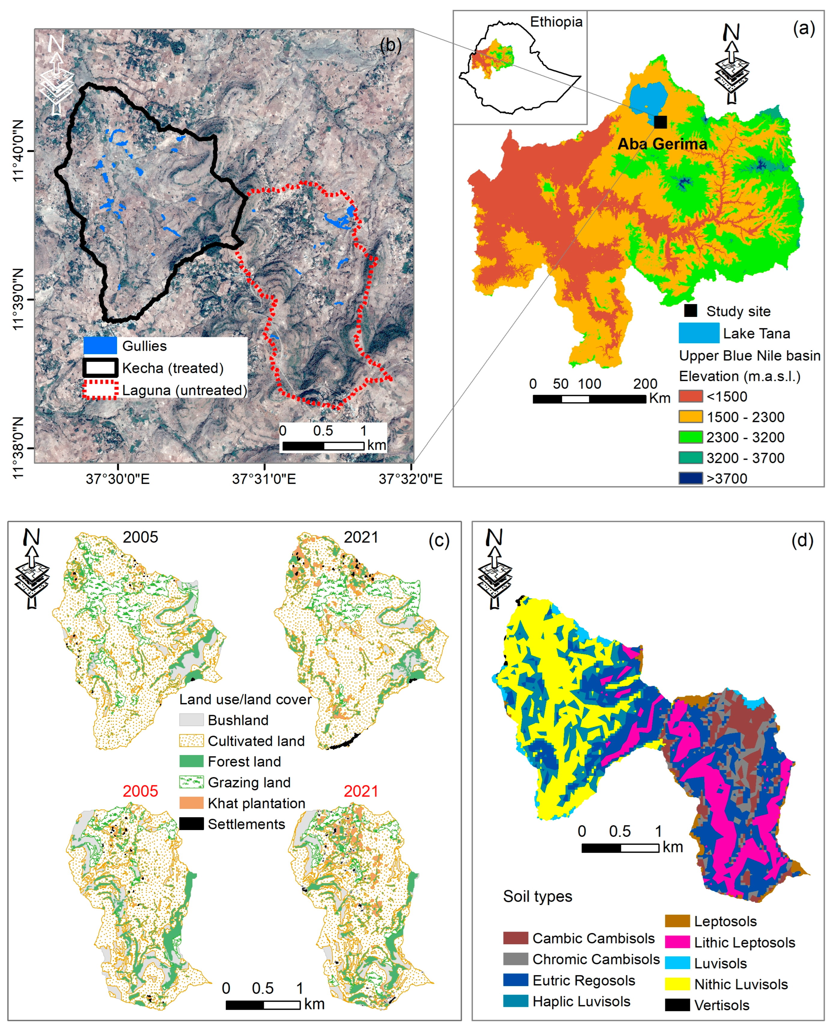
2. Study Area
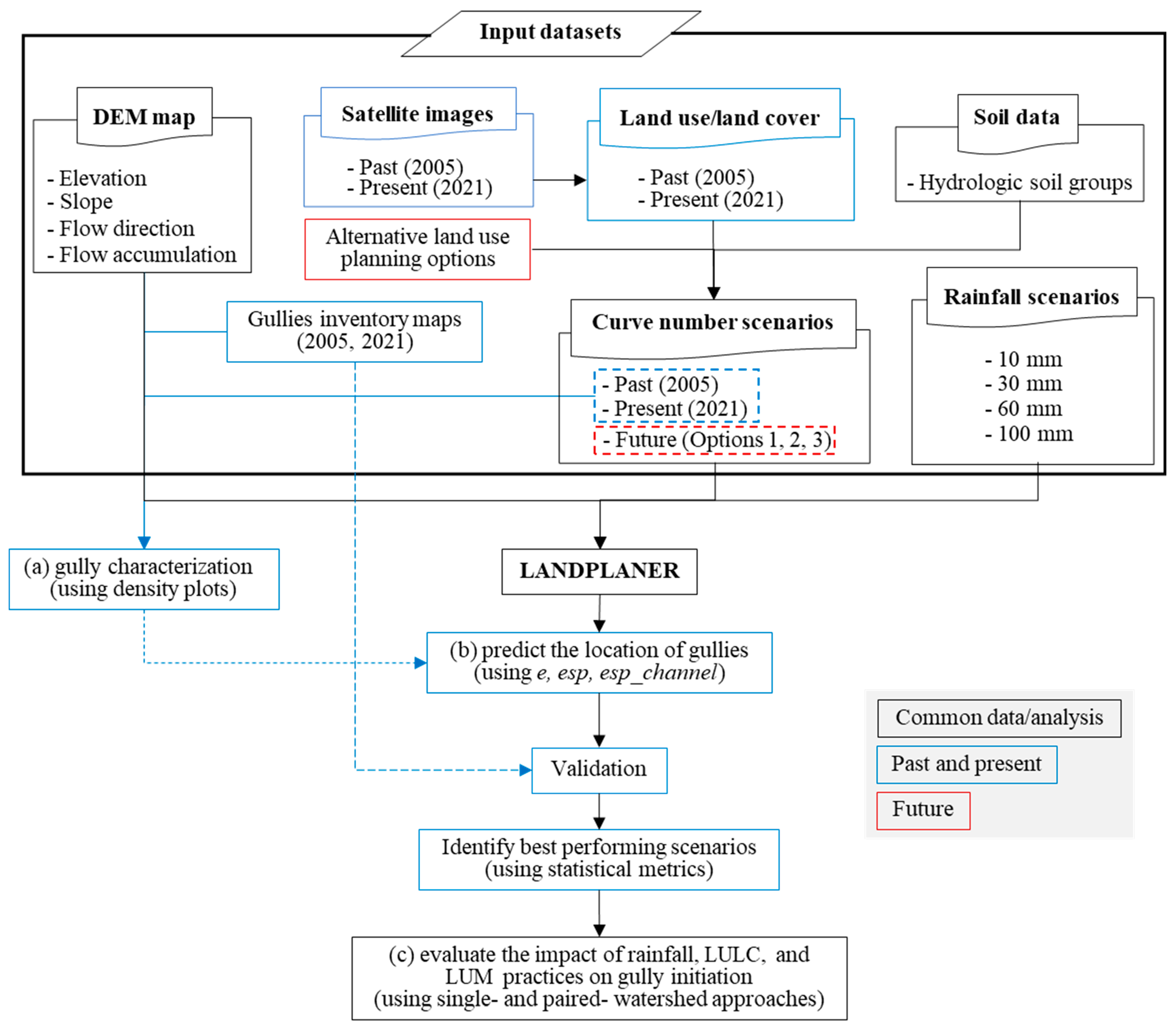
3. Methodology
3.1. LANDPLANER Model
3.1.1. Hydrological Modeling
3.1.2. Erosion Index
3.1.3. Topographic Thresholds
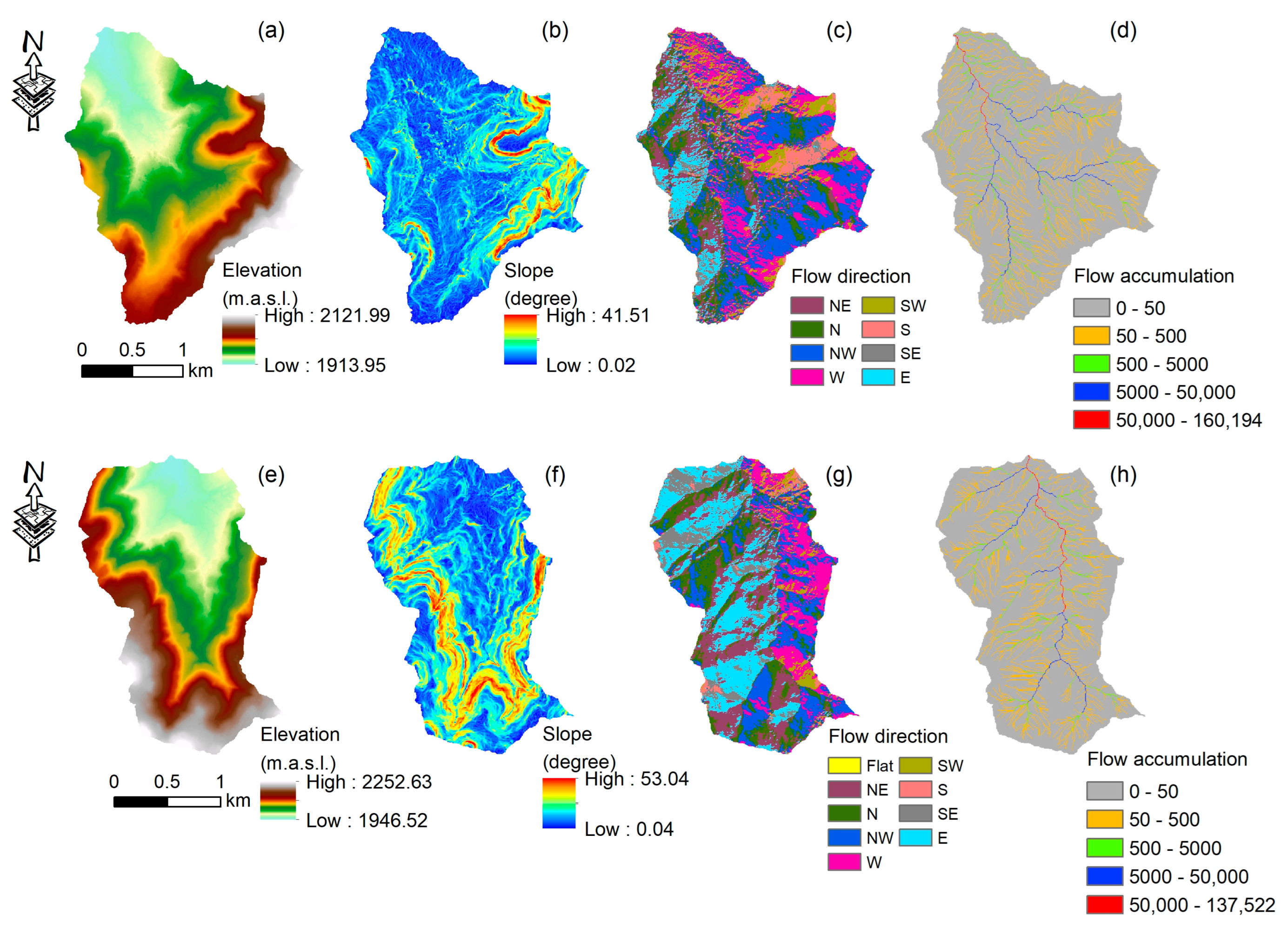
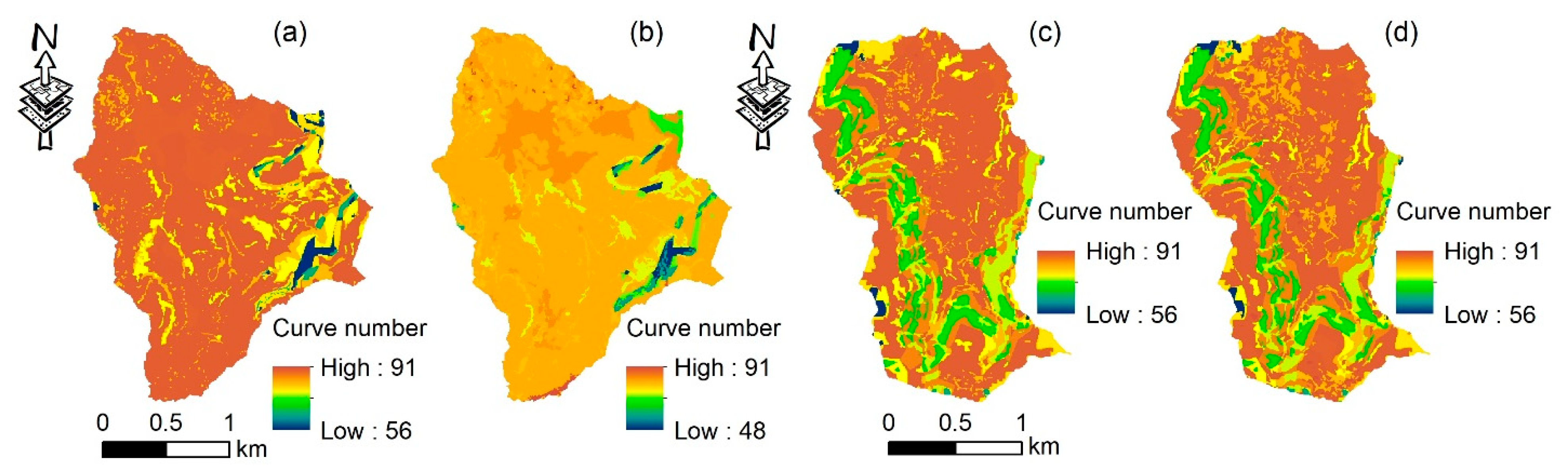
3.2. Preparation and Characterization of Model Input Data
3.3. Validation of Model Prediction Performance
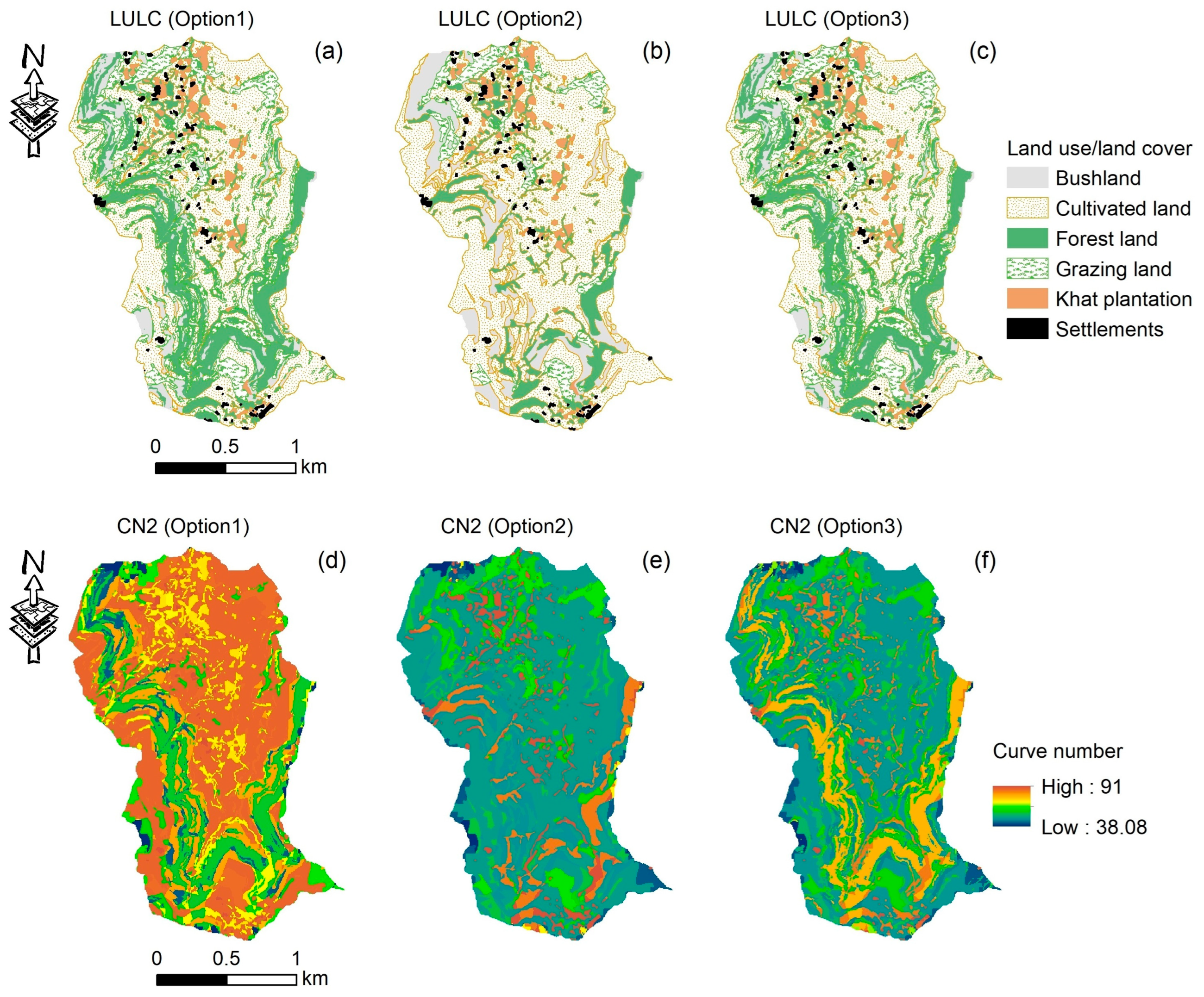
3.4. Assessing the Impact of Rainfall, LULC, and LUM Practices on Gully Erosion
4. Results
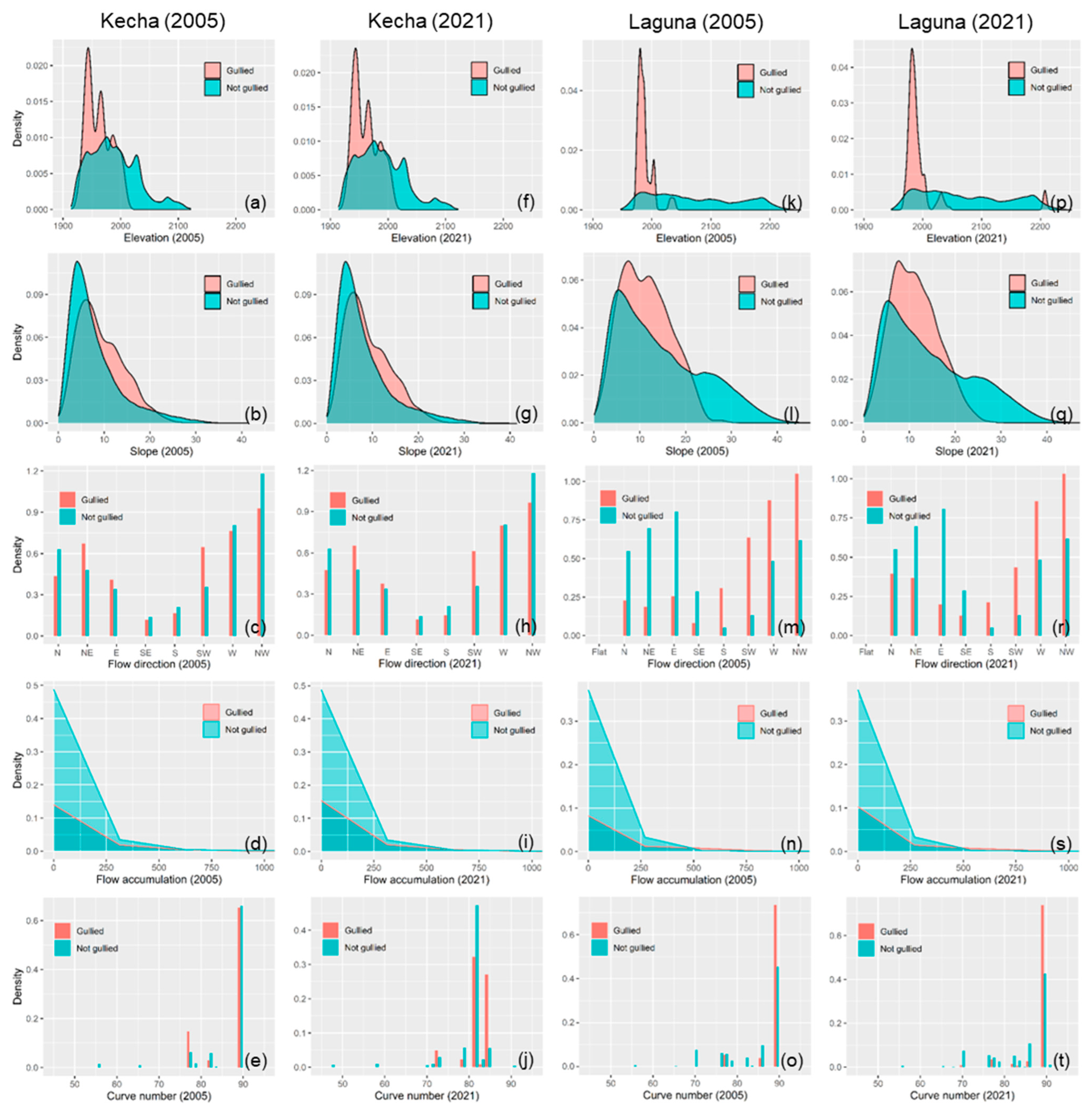
4.1. Characterizing Gully Erosion with Model Input Variables
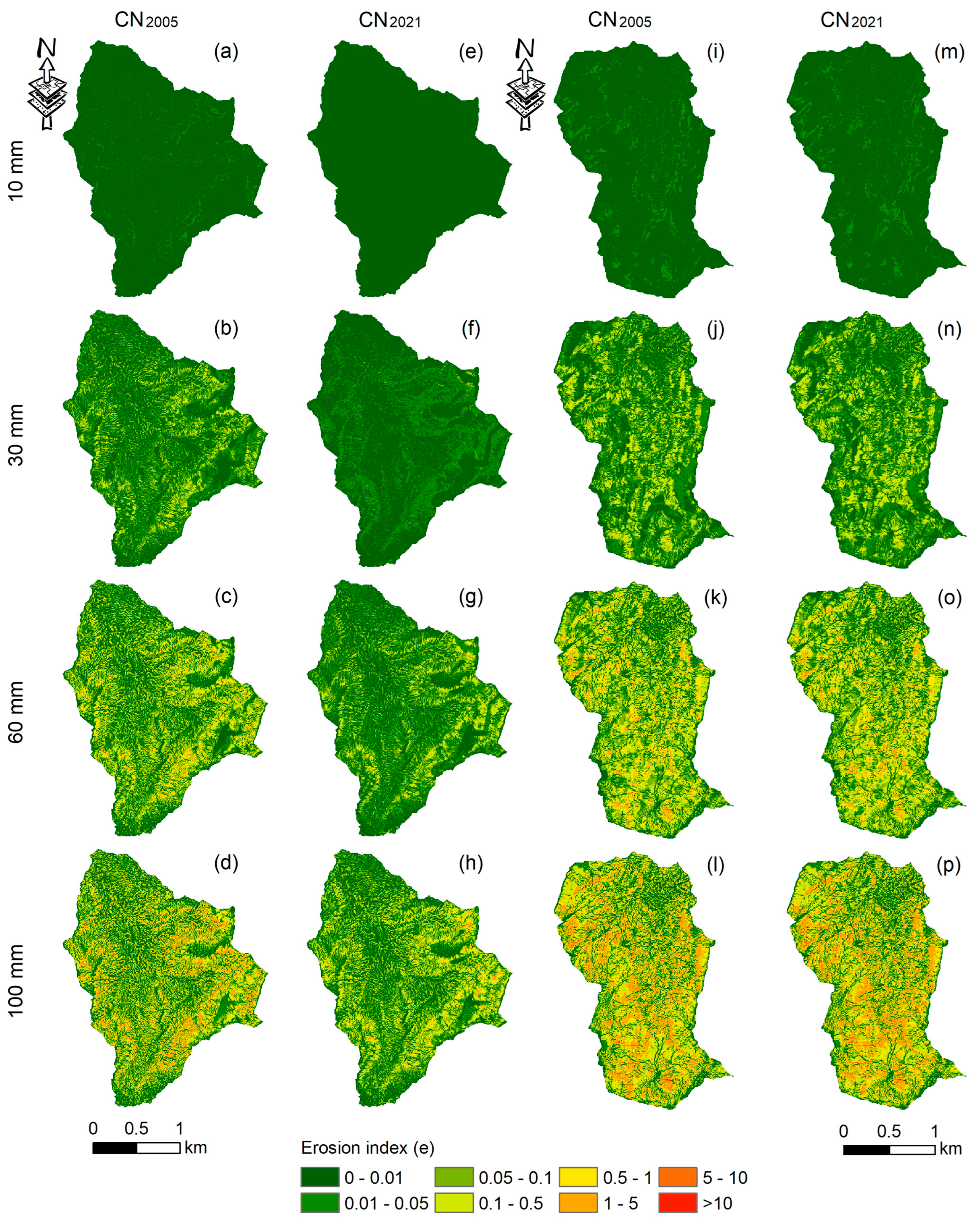
4.2. Evaluating Dynamic and Static Thresholds for Different Rainfall and Curve Number Scenarios
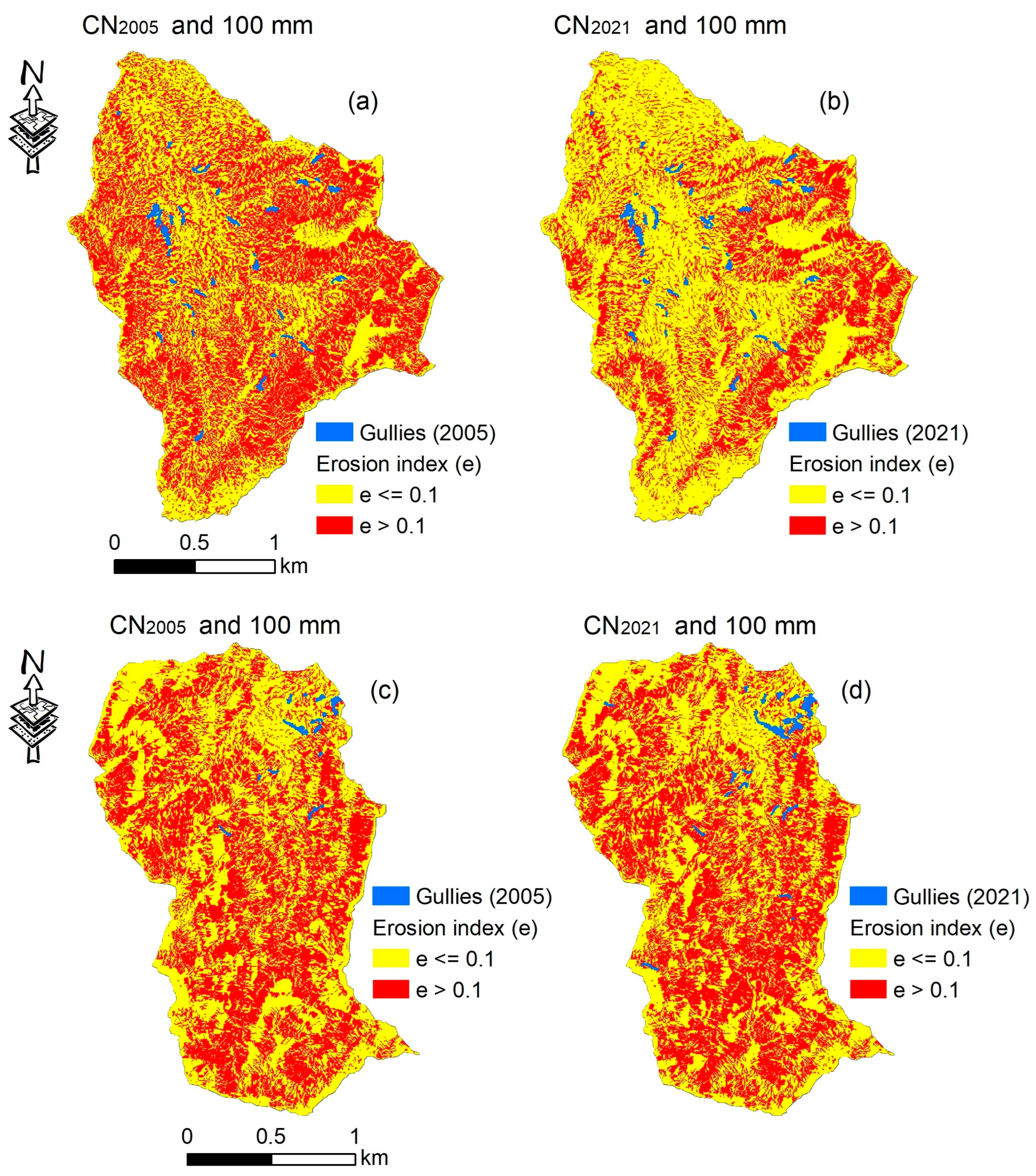
4.2.1. Performance of Erosion Index (e) Thresholds for Different Curve Number and Rainfall Scenarios
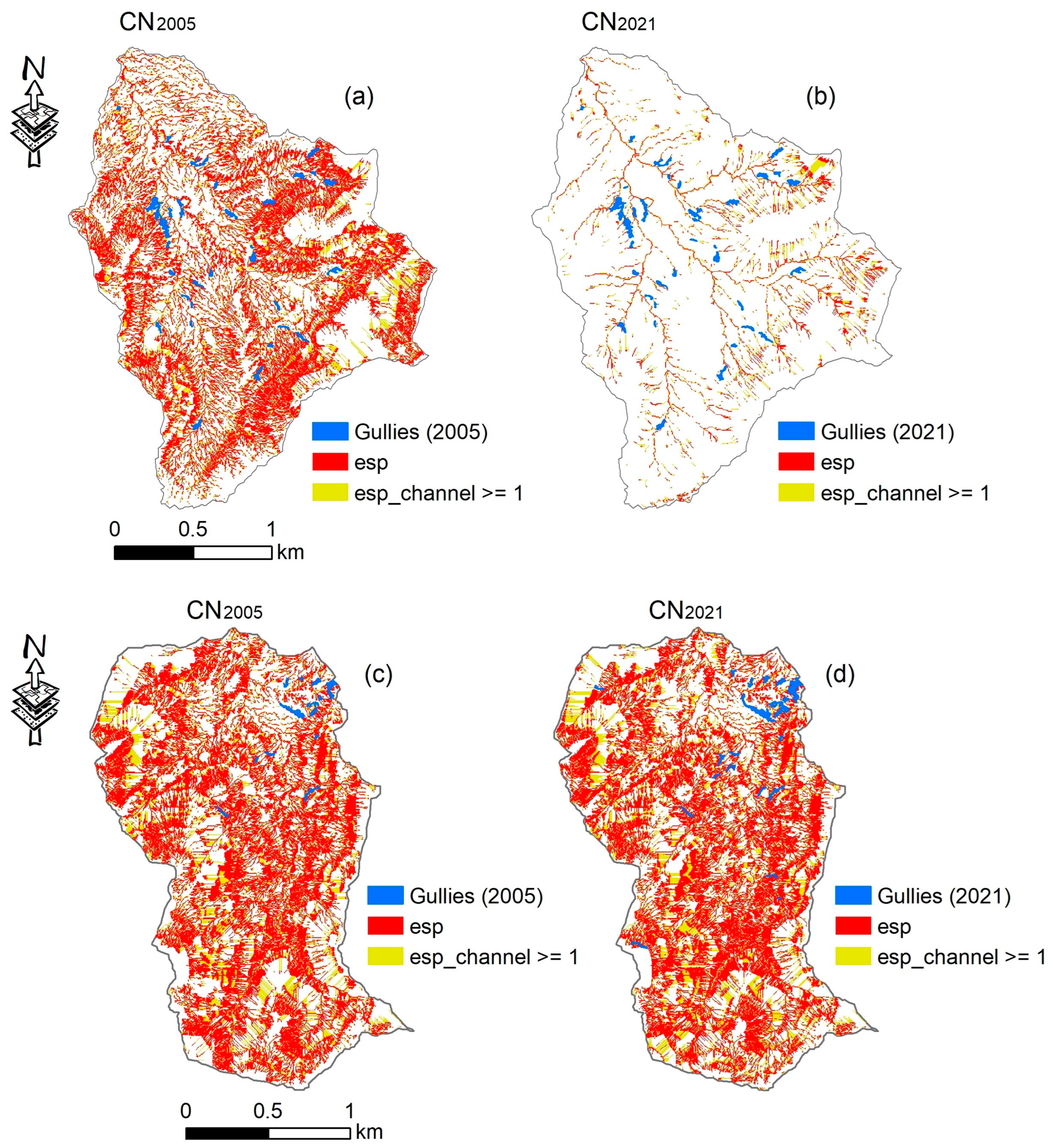
4.2.2. Performance of Topographic (esp) and Erosion Channel (esp_channel) Thresholds for Different Curve Number Scenarios
4.3. Impact of Rainfall Variability, LULC Changes, and LUM Practices on Gully Erosion in the Paired Watersheds
5. Discussion
6. Conclusions and Recommendations
Supplementary Materials
Author Contributions
Funding
Data Availability Statement
Acknowledgments
Conflicts of Interest
References
- Poesen, J.; Nachtergaele, J.; Verstraeten, G.; Valentin, C. Gully erosion and environmental change: Importance and research needs. Catena 2003, 50, 91–133. [Google Scholar] [CrossRef]
- Imeson, A.; Kwaad, F. Gully types and gully prediction. Geogr. Tijdschr. 1980, 14, 430–441. [Google Scholar]
- Brice, J.C. Erosion and Deposition in the Loess-Mantled Great Plains, Medicine Creek Drainage Basin, Nebraska; US Government Printing Office: Washington, DC, USA, 1966.
- Hauge, C. Soil Erosion Definitions; California Department of Forestry: Sacramento, CA, USA, 1977.
- Vanmaercke, M.; Poesen, J.; Van Mele, B.; Demuzere, M.; Bruynseels, A.; Golosov, V.; Bezerra, J.F.R.; Bolysov, S.; Dvinskih, A.; Frankl, A.; et al. How fast do gully headcuts retreat? Earth-Sci. Rev. 2016, 154, 336–355. [Google Scholar] [CrossRef]
- Vanmaercke, M.; Panagos, P.; Vanwalleghem, T.; Hayas, A.; Foerster, S.; Borrelli, P.; Rossi, M.; Torri, D.; Casali, J.; Borselli, L.; et al. Measuring, modelling and managing gully erosion at large scales: A state of the art. Earth-Sci. Rev. 2021, 218, 103637. [Google Scholar] [CrossRef]
- Castillo, C.; Gómez, J. A century of gully erosion research: Urgency, complexity and study approaches. Earth-Sci. Rev. 2016, 160, 300–319. [Google Scholar] [CrossRef]
- Valentin, C.; Poesen, J.; Li, Y. Gully erosion: Impacts, factors and control. Catena 2005, 63, 132–153. [Google Scholar] [CrossRef]
- Kariminejad, N.; Rossi, M.; Hosseinalizadeh, M.; Pourghasemi, H.R.; Santosh, M. Gully head modelling in Iranian Loess Plateau under different scenarios. Catena 2020, 194, 104769. [Google Scholar] [CrossRef]
- Agostini, M.; Mondini, A.C.; Torri, D.; Rossi, M. Modelling seasonal variation of gully erosion at the catchment scale. Earth Surf. Process. Landf. 2022, 47, 436–458. [Google Scholar] [CrossRef]
- Hayas, A.; Poesen, J.; Vanwalleghem, T. Rainfall and vegetation effects on temporal variation of topographic thresholds for gully initiation in Mediterranean cropland and olive groves. Land Degrad. Dev. 2017, 28, 2540–2552. [Google Scholar] [CrossRef]
- Amare, S.; Keesstra, S.; van der Ploeg, M.; Langendoen, E.; Steenhuis, T.; Tilahun, S. Causes and controlling factors of Valley bottom Gullies. Land 2019, 8, 141. [Google Scholar] [CrossRef]
- Tebebu, T.; Abiy, A.; Zegeye, A.; Dahlke, H.; Easton, Z.; Tilahun, S.; Collick, A.; Kidnau, S.; Moges, S.; Dadgari, F.; et al. Surface and subsurface flow effect on permanent gully formation and upland erosion near Lake Tana in the northern highlands of Ethiopia. Hydrol. Earth Syst. Sci. 2010, 14, 2207–2217. [Google Scholar] [CrossRef]
- Zegeye, A.D.; Langendoen, E.J.; Stoof, C.R.; Tilahun, S.A.; Dagnew, D.C.; Zimale, F.A.; Guzman, C.D.; Yitaferu, B.; Steenhuis, T.S. Morphological dynamics of gully systems in the subhumid Ethiopian Highlands: The Debre Mawi watershed. Soil 2016, 2, 443–458. [Google Scholar] [CrossRef]
- Amare, S.; Langendoen, E.; Keesstra, S.; Ploeg, M.v.d.; Gelagay, H.; Lemma, H.; van der Zee, S.E. Susceptibility to gully erosion: Applying random forest (RF) and frequency ratio (FR) approaches to a small catchment in Ethiopia. Water 2021, 13, 216. [Google Scholar] [CrossRef]
- Yibeltal, M.; Tsunekawa, A.; Haregeweyn, N.; Adgo, E.; Meshesha, D.T.; Aklog, D.; Masunaga, T.; Tsubo, M.; Billi, P.; Vanmaercke, M.; et al. Analysis of long-term gully dynamics in different agro-ecology settings. Catena 2019, 179, 160–174. [Google Scholar] [CrossRef]
- Setargie, T.A.; Tsunekawa, A.; Haregeweyn, N.; Tsubo, M.; Fenta, A.A.; Berihun, M.L.; Sultan, D.; Yibeltal, M.; Ebabu, K.; Nzioki, B.; et al. Random Forest–based gully erosion susceptibility assessment across different agro-ecologies of the Upper Blue Nile basin, Ethiopia. Geomorphology 2023, 431, 108671. [Google Scholar] [CrossRef]
- Poesen, J.; Torri, D.; Vanwalleghem, T. Gully erosion: Procedures to adopt when modelling soil erosion in landscapes affected by gullying. In Handbook of Erosion Modelling; Wiley Online Library: Hoboken, NJ, USA, 2011. [Google Scholar]
- Hajigholizadeh, M.; Melesse, A.M.; Fuentes, H.R. Erosion and sediment transport modelling in shallow waters: A review on approaches, models and applications. Int. J. Environ. Res. Public Health 2018, 15, 518. [Google Scholar] [CrossRef]
- Douglas-Mankin, K.R.; Roy, S.K.; Sheshukov, A.Y.; Biswas, A.; Gharabaghi, B.; Binns, A.; Rudra, R.; Shrestha, N.K.; Daggupati, P. A comprehensive review of ephemeral gully erosion models. Catena 2020, 195, 104901. [Google Scholar] [CrossRef]
- Bzdok, D.; Altman, N.; Krzywinski, M. Statistics versus machine learning. Nat Methods 2018, 15, 233–234. [Google Scholar] [CrossRef]
- Ferro, V.; Giordano, G.; Iovino, M. Isoerosivity and erosion risk map for Sicily. Hydrol. Sci. J. 1991, 36, 549–564. [Google Scholar] [CrossRef]
- Rossi, M. Modeling of Landslide Phenomena and Erosion Processes Triggered by Meteo-Climatic Factors. Doctoral Dissertation, University of Perugia, Perugia, Italy, 2014. [Google Scholar] [CrossRef]
- Rossi, M.; Torri, D.; Santi, E. Bias in topographic thresholds for gully heads. Nat. Hazards 2015, 79, 51–69. [Google Scholar] [CrossRef]
- Torri, D.; Poesen, J. A review of topographic threshold conditions for gully head development in different environments. Earth-Sci. Rev. 2014, 130, 73–85. [Google Scholar] [CrossRef]
- Torri, D.; Poesen, J.; Rossi, M.; Amici, V. Gully head modelling: A Mediterranean badland case study. Earth Surf. Process. Landf. 2018, 43, 2547–2561. [Google Scholar] [CrossRef]
- Patton, P.C.; Schumm, S.A. Gully erosion, Northwestern Colorado: A threshold phenomenon. Geology 1975, 3, 88–90. [Google Scholar] [CrossRef]
- Nyssen, J.; Clymans, W.; Descheemaeker, K.; Poesen, J.; Vandecasteele, I.; Vanmaercke, M.; Zenebe, A.; Van Camp, M.; Haile, M.; Haregeweyn, N.; et al. Impact of soil and water conservation measures on catchment hydrological response—A case in north Ethiopia. Hydrol. Process. 2010, 24, 1880–1895. [Google Scholar] [CrossRef]
- Mhiret, D.A.; Dagnew, D.C.; Guzman, C.D.; Alemie, T.C.; Zegeye, A.D.; Tebebu, T.Y.; Langendoen, E.J.; Zaitchik, B.F.; Tilahun, S.A.; Steenhuis, T.S. A nine-year study on the benefits and risks of soil and water conservation practices in the humid highlands of Ethiopia: The Debre Mawi watershed. J. Environ. Manag. 2020, 270, 110885. [Google Scholar] [CrossRef]
- Berihun, M.L.; Tsunekawa, A.; Haregeweyn, N.; Tsubo, M.; Fenta, A.A.; Ebabu, K.; Sultan, D.; Dile, Y.T. Reduced runoff and sediment loss under alternative land capability-based land use and management options in a sub-humid watershed of Ethiopia. J. Hydrol. Reg. Stud. 2022, 40, 100998. [Google Scholar] [CrossRef]
- Ali, S.; Sethy, B.; Singh, R.; Parandiyal, A.; Kumar, A. Quantification of hydrologic response of staggered contour trenching for horti-pastoral land use system in small ravine watersheds: A paired watershed approach. Land Degrad. Dev. 2017, 28, 1237–1252. [Google Scholar] [CrossRef]
- Melaku, N.D.; Renschler, C.S.; Holzmann, H.; Strohmeier, S.; Bayu, W.; Zucca, C.; Ziadat, F.; Klik, A. Prediction of soil and water conservation structure impacts on runoff and erosion processes using SWAT model in the northern Ethiopian highlands. J. Soils Sediments 2018, 18, 1743–1755. [Google Scholar] [CrossRef]
- Berihun, M.L.; Tsunekawa, A.; Haregeweyn, N.; Dile, Y.T.; Tsubo, M.; Fenta, A.A.; Meshesha, D.T.; Ebabu, K.; Sultan, D.; Srinivasan, R. Evaluating runoff and sediment responses to soil and water conservation practices by employing alternative modeling approaches. Sci. Total Environ. 2020, 747, 141118. [Google Scholar] [CrossRef]
- Wilson, G.; Shields, F.; Bingner, R.; Reid-Rhoades, P.; DiCarlo, D.; Dabney, S. Conservation practices and gully erosion contributions in the Topashaw Canal watershed. J. Soil Water Conserv. 2008, 63, 420–429. [Google Scholar] [CrossRef]
- Anderson, R.L.; Rowntree, K.M.; Le Roux, J.J. An interrogation of research on the influence of rainfall on gully erosion. Catena 2021, 206, 105482. [Google Scholar] [CrossRef]
- Hurni, H.; Berhe, W.; Chadhokar, P.; Daniel, D.; Gete, Z.; Grunder, M.; Kassaye, G. Soil and Water Conservation in Ethiopia: Guidelines for Development Agents; Centre for Development and Environment: Bern, Switzerland, 2016. [Google Scholar]
- Mekonnen, G. Soil Characterization, Classification and Mapping of Three Twin Watersheds in the Upper Blue Nile Basin (Aba Gerima, Guder and Dibatie); Final Project Report; Amhara Design and Supervision Works Enterprise: Bahir Dar, Ethiopia, 2016.
- R Core Team. R: A Language and Environment for Statistical Computing; R Foundation for Statistical Computing: Vienna, Austria, 2020; Available online: https://www.R-project.org/ (accessed on 14 March 2023).
- SCS. National Engineering Handbook, Section 4. Hydrology; Soil Conservation Service, US Department of Agriculture: Washington, DC, USA, 1972. [Google Scholar]
- Hawkins, R.H.; Ward, T.J.; Woodward, D.E.; Van Mullem, J.A. Curve Number Hydrology: State of the Practice; American Society of Civil Engineers: Reston, WI, USA, 2008. [Google Scholar]
- ESRI. ArcGIS Pro (v2.6) Software; Environmental Systems Research Institute (ESRI) Inc.: Redlands, CA, USA, 2020. [Google Scholar]
- Neteler, M.; Mitasova, H. Open Source GIS: A GRASS GIS Approach; Springer Science & Business Media: Berlin/Heidelberg, Germany, 2013; Volume 689. [Google Scholar]
- FDRE MoA. Integrated Local Level Participatory Land Use Planning (ILLPLUP) Manual; Rural Land Administration and Use Directorate (RLAUD): Addis Ababa, Ethiopia, 2020. [Google Scholar]
- Evans, R.; Nortcliff, S. Soil erosion in north Norfolk. J. Agric. Sci. 1978, 90, 185–192. [Google Scholar] [CrossRef]
- Speirs, R.B.; Frost, C.A. The increasing incidence of accelerated soil water erosion on arable land in the east of Scotland. Res. Dev. Agric. 1985, 2, 161–167. [Google Scholar]
- Nachtergaele, J. A Spatial and Temporal Analysis of the Characteristics, Importance and Prediction of Ephemeral Gully Erosion. 2001. Available online: https://lirias.kuleuven.be/1737006?limo=0 (accessed on 14 March 2023).
- Prosser, I.P.; Soufi, M. Controls on gully formation following forest clearing in a humid temperate environment. Water Resour. Res. 1998, 34, 3661–3671. [Google Scholar] [CrossRef]
- Begin, Z.; Schumm, S. Instability of alluvial valley floors: A method for its assessment. Trans. ASAE 1979, 22, 347–0350. [Google Scholar] [CrossRef]
- Geroy, I.; Gribb, M.; Marshall, H.-P.; Chandler, D.; Benner, S.G.; McNamara, J.P. Aspect influences on soil water retention and storage. Hydrol. Process. 2011, 25, 3836–3842. [Google Scholar] [CrossRef]
- Svoray, T.; Michailov, E.; Cohen, A.; Rokah, L.; Sturm, A. Predicting gully initiation: Comparing data mining techniques, analytical hierarchy processes and the topographic threshold. Earth Surf. Process. Landf. 2012, 37, 607–619. [Google Scholar] [CrossRef]
- Azareh, A.; Rahmati, O.; Rafiei-Sardooi, E.; Sankey, J.B.; Lee, S.; Shahabi, H.; Ahmad, B.B. Modelling gully-erosion susceptibility in a semi-arid region, Iran: Investigation of applicability of certainty factor and maximum entropy models. Sci. Total Environ. 2019, 655, 684–696. [Google Scholar] [CrossRef]
- Javidan, N.; Kavian, A.; Pourghasemi, H.R.; Conoscenti, C.; Jafarian, Z. Gully erosion susceptibility mapping using multivariate adaptive regression splines—Replications and sample size scenarios. Water 2019, 11, 2319. [Google Scholar] [CrossRef]
- Saha, S.; Roy, J.; Arabameri, A.; Blaschke, T.; Tien Bui, D. Machine learning-based gully erosion susceptibility mapping: A case study of Eastern India. Sensors 2020, 20, 1313. [Google Scholar] [CrossRef]
- Jiang, C.; Fan, W.; Yu, N.; Liu, E. Spatial modeling of gully head erosion on the Loess Plateau using a certainty factor and random forest model. Sci. Total Environ. 2021, 783, 147040. [Google Scholar] [CrossRef] [PubMed]
- Sidorchuk, A. Dynamic and static models of gully erosion. Catena 1999, 37, 401–414. [Google Scholar] [CrossRef]
- Frankl, A.; Poesen, J.; Deckers, J.; Haile, M.; Nyssen, J. Gully head retreat rates in the semi-arid highlands of Northern Ethiopia. Geomorphology 2012, 173, 185–195. [Google Scholar] [CrossRef]
- Herweg, K.; Ludi, E. The performance of selected soil and water conservation measures—Case studies from Ethiopia and Eritrea. Catena 1999, 36, 99–114. [Google Scholar] [CrossRef]
- Adimassu, Z.; Langan, S.; Johnston, R.; Mekuria, W.; Amede, T. Impacts of soil and water conservation practices on crop yield, run-off, soil loss and nutrient loss in Ethiopia: Review and synthesis. Environ. Manag. 2017, 59, 87–101. [Google Scholar] [CrossRef] [PubMed]
- Wolka, K.; Biazin, B.; Martinsen, V.; Mulder, J. Soil and water conservation management on hill slopes in Southwest Ethiopia. I. Effects of soil bunds on surface runoff, erosion and loss of nutrients. Sci. Total Environ. 2021, 757, 142877. [Google Scholar] [CrossRef]


| Study Site | Satellite Sensor | Spectral Resolution | Spatial Resolution (m) | Acquisition Date (Day Month Year) |
|---|---|---|---|---|
| Aba Gerima | QuickBird | Multispectral | 0.6 × 0.6 | 6 March 2005 |
| Pleiades | Multispectral | 0.5 × 0.5 | 7 January 2021 |
| Watershed | Scenario | e | Gully Channel-Based Performance | Gully Head-Based Performance | |||||||||||
|---|---|---|---|---|---|---|---|---|---|---|---|---|---|---|---|
| Curve Number | Rainfall(mm) | TPR | TNR | FPR | FNR | OA | TPR | TNR | FPR | FNR | OA | ||||
| Kecha | CN2005 (untreated) | 100 | 0.01 | 0.557 | 0.400 | 0.600 | 0.443 | 0.401 | 0.478 | 0.848 | 0.400 | 0.600 | 0.152 | 0.400 | 0.624 |
| 0.05 | 0.557 | 0.400 | 0.600 | 0.443 | 0.402 | 0.478 | 0.848 | 0.401 | 0.599 | 0.152 | 0.401 | 0.625 | |||
| 0.1 | 0.495 | 0.494 | 0.506 | 0.505 | 0.494 | 0.495 | 0.758 | 0.494 | 0.506 | 0.242 | 0.494 | 0.626 | |||
| 0.5 | 0.230 | 0.799 | 0.201 | 0.770 | 0.794 | 0.515 | 0.394 | 0.799 | 0.201 | 0.606 | 0.799 | 0.597 | |||
| 1 | 0.121 | 0.905 | 0.095 | 0.879 | 0.898 | 0.513 | 0.242 | 0.905 | 0.095 | 0.758 | 0.905 | 0.574 | |||
| 5 | 0.012 | 0.997 | 0.003 | 0.988 | 0.988 | 0.505 | 0.030 | 0.997 | 0.003 | 0.970 | 0.997 | 0.514 | |||
| 10 | 0.002 | 1.000 | 0.000 | 0.998 | 0.991 | 0.501 | 0.000 | 1.000 | 0.000 | 1.000 | 0.999 | 0.500 | |||
| CN2021 (treated) | 100 | 0.01 | 0.552 | 0.400 | 0.600 | 0.448 | 0.401 | 0.476 | 0.750 | 0.400 | 0.600 | 0.250 | 0.401 | 0.575 | |
| 0.05 | 0.551 | 0.402 | 0.598 | 0.449 | 0.404 | 0.477 | 0.750 | 0.403 | 0.597 | 0.250 | 0.403 | 0.576 | |||
| 0.1 | 0.386 | 0.670 | 0.330 | 0.614 | 0.667 | 0.528 | 0.525 | 0.669 | 0.331 | 0.475 | 0.669 | 0.597 | |||
| 0.5 | 0.088 | 0.947 | 0.053 | 0.912 | 0.939 | 0.517 | 0.100 | 0.947 | 0.053 | 0.900 | 0.947 | 0.523 | |||
| 1 | 0.030 | 0.988 | 0.012 | 0.970 | 0.979 | 0.509 | 0.050 | 0.988 | 0.012 | 0.950 | 0.988 | 0.519 | |||
| 5 | 0.000 | 1.000 | 0.000 | 1.000 | 0.990 | 0.500 | 0.000 | 1.000 | 0.000 | 1.000 | 1.000 | 0.500 | |||
| 10 | 0.000 | 1.000 | 0.000 | 1.000 | 0.990 | 0.500 | 0.000 | 1.000 | 0.000 | 1.000 | 1.000 | 0.500 | |||
| Laguna | CN2005 (untreated) | 60 | 0.01 | 0.640 | 0.293 | 0.707 | 0.360 | 0.294 | 0.466 | 0.846 | 0.293 | 0.707 | 0.154 | 0.293 | 0.570 |
| 0.05 | 0.640 | 0.296 | 0.704 | 0.360 | 0.297 | 0.468 | 0.846 | 0.296 | 0.704 | 0.154 | 0.296 | 0.571 | |||
| 0.1 | 0.547 | 0.516 | 0.484 | 0.453 | 0.516 | 0.532 | 0.769 | 0.516 | 0.484 | 0.231 | 0.516 | 0.643 | |||
| 0.5 | 0.203 | 0.852 | 0.148 | 0.797 | 0.850 | 0.528 | 0.231 | 0.852 | 0.148 | 0.769 | 0.852 | 0.542 | |||
| 1 | 0.063 | 0.952 | 0.048 | 0.937 | 0.948 | 0.507 | 0.077 | 0.952 | 0.048 | 0.923 | 0.951 | 0.514 | |||
| 5 | 0.004 | 0.999 | 0.001 | 0.996 | 0.995 | 0.501 | 0.000 | 0.999 | 0.001 | 1.000 | 0.999 | 0.499 | |||
| 10 | 0.000 | 1.000 | 0.000 | 1.000 | 0.996 | 0.500 | 0.000 | 1.000 | 0.000 | 1.000 | 1.000 | 0.500 | |||
| CN2021 (untreated) | 60 | 0.01 | 0.621 | 0.293 | 0.707 | 0.379 | 0.295 | 0.457 | 0.760 | 0.293 | 0.707 | 0.240 | 0.293 | 0.527 | |
| 0.05 | 0.621 | 0.296 | 0.704 | 0.379 | 0.298 | 0.458 | 0.760 | 0.296 | 0.704 | 0.240 | 0.297 | 0.528 | |||
| 0.1 | 0.526 | 0.508 | 0.492 | 0.474 | 0.508 | 0.517 | 0.560 | 0.508 | 0.492 | 0.440 | 0.508 | 0.534 | |||
| 0.5 | 0.194 | 0.850 | 0.150 | 0.806 | 0.844 | 0.522 | 0.160 | 0.849 | 0.151 | 0.840 | 0.849 | 0.505 | |||
| 1 | 0.071 | 0.952 | 0.048 | 0.929 | 0.945 | 0.511 | 0.080 | 0.951 | 0.049 | 0.920 | 0.951 | 0.516 | |||
| 5 | 0.002 | 0.999 | 0.001 | 0.998 | 0.991 | 0.500 | 0.000 | 0.999 | 0.001 | 1.000 | 0.999 | 0.499 | |||
| 10 | 0.000 | 1.000 | 0.000 | 1.000 | 0.992 | 0.500 | 0.000 | 1.000 | 0.000 | 1.000 | 1.000 | 0.500 | |||
| Watershed | Threshold | Scenario | Gully Channel-Based Performance | Gully Head-Based Performance | ||||||||||
|---|---|---|---|---|---|---|---|---|---|---|---|---|---|---|
| Curve Number | TPR | TNR | FPR | FNR | OA | TPR | TNR | FPR | FNR | OA | ||||
| Kecha (treated) | esp | CN2005 | 0.411 | 0.666 | 0.334 | 0.589 | 0.664 | 0.539 | 0.515 | 0.666 | 0.334 | 0.485 | 0.666 | 0.590 |
| CN2021 | 0.083 | 0.951 | 0.049 | 0.917 | 0.942 | 0.517 | 0.150 | 0.951 | 0.049 | 0.850 | 0.950 | 0.550 | ||
| esp_channel | CN2005 | 0.540 | 0.545 | 0.455 | 0.460 | 0.545 | 0.543 | 0.667 | 0.544 | 0.456 | 0.333 | 0.544 | 0.606 | |
| CN2021 | 0.145 | 0.913 | 0.087 | 0.855 | 0.906 | 0.529 | 0.250 | 0.913 | 0.087 | 0.750 | 0.913 | 0.581 | ||
| Laguna (untreated) | esp | CN2005 | 0.619 | 0.578 | 0.422 | 0.381 | 0.578 | 0.599 | 0.692 | 0.577 | 0.423 | 0.308 | 0.577 | 0.635 |
| CN2021 | 0.587 | 0.575 | 0.425 | 0.413 | 0.575 | 0.581 | 0.680 | 0.574 | 0.426 | 0.320 | 0.574 | 0.627 | ||
| esp_channel | CN2005 | 0.760 | 0.443 | 0.557 | 0.240 | 0.444 | 0.601 | 0.846 | 0.442 | 0.558 | 0.154 | 0.442 | 0.644 | |
| CN2021 | 0.698 | 0.430 | 0.570 | 0.302 | 0.432 | 0.564 | 0.760 | 0.429 | 0.571 | 0.240 | 0.429 | 0.595 | ||
| Watershed | Scenario | Impact of Rainfall | Gully Initiation | ||||||||
|---|---|---|---|---|---|---|---|---|---|---|---|
| Curve Number | Rainfall (mm Day−1) | Min. | Max. | Mean | St. Dev. | Times * (Compared to 30 mm) | Change ** (%) (from 2005) | Gully Initiation (Pixels) | Gully Initiation (%) | Change ** (%) (from 2005) | |
| Kecha | CN2005 | 10 | 0.00 | 0.05 | 0.00 | 0.00 | - | - | 53,585 | 33 | - |
| 30 | 0.00 | 1.37 | 0.03 | 0.06 | - | - | |||||
| 60 | 0.00 | 8.78 | 0.15 | 0.29 | 4 | - | |||||
| 100 | 0.00 | 28.45 | 0.35 | 0.72 | 10 | - | |||||
| CN2021 | 10 | 0.00 | 0.01 | 0.00 | 0.00 | - | - | 7910 | 5 | −28 | |
| 30 | 0.00 | 0.24 | 0.01 | 0.01 | - | −79 | |||||
| 60 | 0.00 | 2.36 | 0.04 | 0.07 | 5 | −72 | |||||
| 100 | 0.00 | 12.57 | 0.12 | 0.25 | 17 | −64 | |||||
| Laguna | CN2005 | 10 | 0.00 | 0.06 | 0.00 | 0.00 | - | - | 58,145 | 42 | - |
| 30 | 0.00 | 2.29 | 0.05 | 0.08 | - | - | |||||
| 60 | 0.00 | 17.44 | 0.25 | 0.47 | 5 | - | |||||
| 100 | 0.00 | 48.73 | 0.66 | 1.32 | 13 | - | |||||
| CN2021 | 10 | 0.00 | 0.06 | 0.00 | 0.00 | - | - | 58,633 | 43 | 1 | |
| 30 | 0.00 | 2.25 | 0.05 | 0.08 | - | 0 | |||||
| 60 | 0.00 | 13.03 | 0.25 | 0.46 | 5 | 1 | |||||
| 100 | 0.00 | 53.82 | 0.67 | 1.31 | 13 | 2 | |||||
| Watershed | Scenario | Impact of Rainfall | Gully Initiation | ||||||||
|---|---|---|---|---|---|---|---|---|---|---|---|
| Curve Number | Rainfall (mm Day−1) | Min. | Max. | Mean | St. Dev. | Times * (Compared to 30 mm) | Change ** (%) (from Baseline) | Gully Initiation (Pixels) | Gully Initiation (%) | Change ** (%) (from Baseline) | |
| Laguna | CN2021 (Baseline) | 10 | 0.00 | 0.06 | 0.00 | 0.00 | - | - | 58,633 | 43 | - |
| 30 | 0.00 | 2.25 | 0.05 | 0.08 | - | - | |||||
| 60 | 0.00 | 13.03 | 0.25 | 0.46 | 5 | - | |||||
| 100 | 0.00 | 53.82 | 0.67 | 1.31 | 13 | - | |||||
| CNoption1 | 10 | 0.00 | 0.06 | 0.00 | 0.00 | - | - | 57,838 | 42 | −1 | |
| 30 | 0.00 | 2.02 | 0.05 | 0.08 | - | −6 | |||||
| 60 | 0.00 | 12.10 | 0.24 | 0.43 | 5 | −5 | |||||
| 100 | 0.00 | 46.27 | 0.65 | 1.23 | 13 | −3 | |||||
| CNoption2 | 10 | 0.00 | 0.04 | 0.00 | 0.00 | - | - | 4971 | 4 | −39 | |
| 30 | 0.00 | 0.52 | 0.00 | 0.01 | - | −96 | |||||
| 60 | 0.00 | 1.86 | 0.01 | 0.05 | 5 | −95 | |||||
| 100 | 0.00 | 6.14 | 0.04 | 0.16 | 17 | −94 | |||||
| CNoption3 | 10 | 0.00 | 0.04 | 0.00 | 0.00 | - | - | 8144 | 6 | −37 | |
| 30 | 0.00 | 0.53 | 0.00 | 0.01 | - | −93 | |||||
| 60 | 0.00 | 1.89 | 0.02 | 0.06 | 5 | −91 | |||||
| 100 | 0.00 | 8.04 | 0.07 | 0.21 | 18 | −89 | |||||
Disclaimer/Publisher’s Note: The statements, opinions and data contained in all publications are solely those of the individual author(s) and contributor(s) and not of MDPI and/or the editor(s). MDPI and/or the editor(s) disclaim responsibility for any injury to people or property resulting from any ideas, methods, instructions or products referred to in the content. |
© 2023 by the authors. Licensee MDPI, Basel, Switzerland. This article is an open access article distributed under the terms and conditions of the Creative Commons Attribution (CC BY) license (https://creativecommons.org/licenses/by/4.0/).
Share and Cite
Setargie, T.A.; Tsunekawa, A.; Haregeweyn, N.; Tsubo, M.; Rossi, M.; Ardizzone, F.; Vanmaercke, M.; De Geeter, S.; Fenta, A.A.; Ebabu, K.; et al. Modeling of Gully Erosion in Ethiopia as Influenced by Changes in Rainfall and Land Use Management Practices. Land 2023, 12, 947. https://doi.org/10.3390/land12050947
Setargie TA, Tsunekawa A, Haregeweyn N, Tsubo M, Rossi M, Ardizzone F, Vanmaercke M, De Geeter S, Fenta AA, Ebabu K, et al. Modeling of Gully Erosion in Ethiopia as Influenced by Changes in Rainfall and Land Use Management Practices. Land. 2023; 12(5):947. https://doi.org/10.3390/land12050947
Chicago/Turabian StyleSetargie, Tadesual Asamin, Atsushi Tsunekawa, Nigussie Haregeweyn, Mitsuru Tsubo, Mauro Rossi, Francesca Ardizzone, Matthias Vanmaercke, Sofie De Geeter, Ayele Almaw Fenta, Kindiye Ebabu, and et al. 2023. "Modeling of Gully Erosion in Ethiopia as Influenced by Changes in Rainfall and Land Use Management Practices" Land 12, no. 5: 947. https://doi.org/10.3390/land12050947