1. Introduction
The Lake Texcoco area has been plagued by environmental degradation and sociopolitical conflicts resulting from disagreements between local communities and federal authorities over natural resource use. Despite numerous proposals, few have been realized, and many have been abandoned or cancelled midway. To break this cycle of struggle and environmental deterioration, it is crucial to examine the historical context of environmental policies and their impact on the area’s social and ecological systems.
To examine this case, we take the focus of historical political ecology (HPE) that allows the reconstruction of the history of socioenvironmental change in the former Lake Texcoco, which is linked with the changes in policies that have affected the ecology of the Lower Basin of Mexico, with the aim of providing some clues as to the origin of current problems arising from recent attempts to manage the Federal Zone of Lake Texcoco (FZLT).
Through political ecology, environmental transformations and socio-territorial problems can be studied considering the economic, political, and cultural contexts. Although there are several definitions with a different emphasis within political ecology, the agreed consensus is that the environment is not politically inert. Bryant and Bailey [
1] explain that environmental problems cannot be fully understood in isolation from the political and economic context within which they originate and refer to this property as a “politized environment”.
Political ecology has an intrinsic historical component due to some processes, transformations, and dynamics that take place in ecological configurations, and despite the fact that historical analysis is not used by all political ecologists, some human relations with the environment, territory, or natural resources are better understood in their temporal trajectories [
2]. The emphasis on the historical dimension of HPE seeks to explain the present and inform decision makers to help improve social justice and nature conservation [
3].
Historical approaches to political ecology vary, but they all share the influence of critical social theory as well as multiple research methods, such as documentary review and ethnographic and biophysical methods. They are oriented toward solving problems with social, environmental, and political relevance, and they reveal the political nature of problems that are presented as apolitical environmental problems with simple technical solutions through historical reconstruction or deconstruction [
4].
Other historical disciplines that study changes in nature, such as historical geography or environmental history, trace the phenomenological flow of events using available information as well as ethnographic and biophysical tools. Nonetheless, HPE is distinguished by the contribution of critical social theory, with which a history of the articulations between politics, nature, and society is presented rather than a story of a place [
5].
By examining the physical and political-economic history of the FZLT, we conclude that efforts to manage and use it have been hampered because they overlap with existing and unresolved contradictions inherited from the past. It begins with a degraded and transformed ecosystem as a result of Spanish colonization, and once Mexico regains independence, it faces significant challenges in meeting the needs and demands of a polarized society in Mexico’s valley basin.
The current landscape of the space configuration of the former Lake Texcoco was heavily influenced by two key historical moments: the Mexican Revolution and the sociopolitical transformations that swept through Mexico City between 1900 and 1960. The result on the west side of the former lake is the formation of two of the cities with the highest population density in the country, which face problems of poverty, insecurity, and a lack of public services. Meanwhile, east of the lake, the Revolution strengthened agricultural traditions that predate the Spanish conquest.
In light of these two forces that exert pressure on lake resources, we examine federal projects promoted by the government over the last century, the social controversies that have resulted, and the impact on the area’s natural ecosystem.
We demonstrate that conservation and exploitation of natural resources policies that did not take into account the region’s social ecology or social histories failed. We emphasize the importance of HPE in identifying historical sociopaths and understanding ecological changes that can help advance science and biodiversity conservation policies. The basin’s ability to regulate water and resolve conflicts is compromised due to a lack of historical analysis.
3. Research Methodology and Theoretical Approach
During the latter half of the 20th century, the adverse outcomes associated with the modification of the natural environment due to human activities, including the depletion of tropical forests and the utilization of pesticides and agrochemicals, came to the forefront, resulting in the inclusion of environmental concerns in national and global political agendas. This development was prompted by societal outrage over the degradation caused by industrialization and the exploitation of natural resources, which resulted in neocolonial imperialistic expansion and the birth of environmentalism [
16].
Early academic works by Carson [
17], Ehrlich [
18], Hardin [
19], and Commoner [
20] presented catastrophic interpretations of environmental problems and advocated for drastic solutions based on containment. These perspectives align with neo-Malthusian thought, as they offer apolitical explanations for environmental deterioration. However, such approaches have been criticized for their limited ability to explain the root causes of environmental degradation and for their inability to provide effective preventive or corrective actions [
16].
Political ecology emerged as a response to the necessity of comprehending environmental issues in their interplay with sociopolitical factors, while simultaneously challenging Julian Steward’s cultural ecology [
21] and Rappaport’s ecological anthropology [
22], which analyzed the relationship between cultural elements and the utilization of natural resources. These positions only considered the ecological and cultural dimensions, neglecting the economic and power relations inherent in production processes that result in environmental degradation. This early stage of political ecology is known as neo-Marxist.
Durand and colleagues [
16] provide an insightful and concise overview of the neo-Marxist school of thought in political ecology. In their work, they argue that environmental degradation is a direct result of the laws of capitalism, class struggles, and the subordinate position of the third world. The authors argument that this approach prioritizes the material aspects of social structure while underemphasizing the role of local political processes and social actors in understanding the root causes of environmental degradation. They suggest that the fall of real socialism in the late 1980s and the subsequent environmental deterioration experienced by countries adhering to this paradigm served as a catalyst for the emergence of a new approach within political ecology.
In the literature, this stage is commonly referred to as multisectoral environmentalism [
23] or the institutionalization of environmentalism [
24]. At this stage, there is a renewed interest in power relations and the dominance exerted by different actors, as well as each actor’s interest in the resources. The central premise of this stage of political ecology is that “conflicts over the distribution and access to natural resources, as well as environmental change, are the result of unequal power relations” [
25,
26].
Poststructuralist approaches in political ecology focus on the immaterial dimensions of power, emphasizing the role of language and knowledge in shaping the understanding of nature and its degradation over time. These approaches suggest that reality is socially constructed, and power is exercised through the production and dissemination of knowledge that promotes a particular vision of reality. Scholars such as Escobar [
27], Braun and Wainwright [
28], and Escobar and Paulson [
29] have emphasized the importance of analyzing the historical construction of environmental degradation and the ways in which language and knowledge serve as mediators in this process. In this view, power is not only material but also symbolic and discursive, and it is wielded through the ability to construct and control dominant narratives about nature and environmental issues.
Incorporating discourse analysis into political ecology has allowed for an understanding of diverse modes of conceptualizing nature. As noted by Escobar [
30], discourse holds the potential to generate and reproduce asymmetrical power dynamics. Struggles over natural resources are not solely of material significance; rather, they are generated through the meanings that actors ascribe to them.
To address the lack of a framework for explanatory diagnosis in Marxist and poststructuralist approaches, neo-Gramscian and critical realist perspectives have emerged. The neo-Gramscian approach examines the micropolitics of natural resource governance within the context of a historicized state and colonial environment, highlighting the hegemonic role of benefactors and private interests [
31,
32]. However, this analysis prioritizes the political aspects of the initiative and gives little attention to the ecological factor.
In contrast to poststructuralist perspectives, critical realism in political ecology recognizes mediation as a fundamental aspect that shapes the relationship between nature and society. Critical realists argue that causal factors and social structures can exist independently of any imagery and linguistic interpretation, as they are not contingent upon human perceptions. Unlike poststructuralists, who may rationalize environmental degradation as a product of discursive constructions, critical realists seek to critically evaluate the ways in which various actors impact the natural environment.
Informed by Roy Bhaskar’s “
A Realist Theory of Science”, first published in 1975, a faction of critical realism advocates for a political ecological perspective that exposes the inextricable entanglement of social and political structures in the quest for scientific understanding of environmental crises [
33]. This approach stresses the importance of acknowledging the role of power dynamics in shaping environmental science, and calls for the development of a political philosophy of environmental science that recognizes the need for critical evaluation of scientific knowledge and methods. By situating scientific knowledge within a broader sociopolitical context, this perspective seeks to promote a more nuanced and just approach to environmental problem solving.
Political ecology is a multifaceted field that is deeply rooted in critical social theory and employs diverse research methods such as document analysis, ethnography, and biophysical analysis in its pursuit of solving sociopolitical and environmental problems. Through historical reconstruction or deconstruction, it exposes the political dimensions of issues that are often portrayed as purely technical environmental problems with simple solutions [
4]. This approach distinguishes it from other disciplines with historical perspectives, such as environmental history and historical geography, which trace the events and changes in nature using available data and biophysical and ethnographic techniques.
HPE seeks to explore the articulations between politics and environment, rather than simply presenting a story of a place. The earliest works with a historical focus were conducted in colonized third-world nations grappling with social and environmental problems resulting from colonization. For instance, an analysis of Nigeria from the precolonial period to the modern era highlighted the differences between apolitical explanations of natural disasters and the hidden violence of historical changes in the political economy and their devastating socioenvironmental costs [
34]. Similarly, an examination of forest use policies in Java, Indonesia, showed how changes in the nature–society relationship were manipulated to maintain social and environmental control [
25].
Political ecology has revealed the crucial importance of historical analysis in uncovering the underlying political and social frameworks that have contributed to environmental problems. Within this field, numerous scholars have traced the transformation of landscapes and social relationships, linking them to colonial origins and the power relations that have shaped current knowledge and practices. The works of Leach and Mearns [
35], Neumann [
36], Fairhead and Leach [
37], Goldman [
38], Davis [
39], Wainwright [
40], and Hecht, [
41], among others, have demonstrated how the laws enacted after colonial periods favored certain aristocratic groups and how the colonial elite viewed the “wild” and its resources.
As Mann [
31] and Peet, Robbins, and Watts [
42] have emphasized that the historical moment in which current knowledge and practices originated is critical for revealing power relations in the production, circulation, and operationalization of knowledge. Davis’s research in Morocco showed that the production of environmental knowledge was used to promote the colonial and early 20th-century environmental narrative, and that indigenous uses of the environment can better adapt to the ecological dynamics of the territory [
39]. Recent progress has been made in analyzing HPE in first-world nations, such as Braun’s detailed historical analysis of the Canadian West Coast Forest and the denial of equitable participation in decision making over forest resources for indigenous populations [
43].
Strategic use of historical context has been essential in making persuasive arguments about environmental subjectivities and conflicts, as demonstrated in works such as Robbins’s
Lawn People [
44] and Kosek’s
Understories [
5]. Robbins investigates the use of toxic chemicals by “good citizens” to maintain the ideal suburban lawn, while Kosek discusses how elements of race and nature have combined to form various subjectivities and conflicts. By tracing the historical development of environmental problems and subjectivities, political ecology provides a critical lens through which to analyze the complex social, political, and economic dimensions of environmental issues.
The emergence of political ecology as a theoretical tool has challenged the deterministic belief that environmental problems and natural resource degradation are solely linked to poverty, hunger, and marginalization. Scholars such as Piers Blaikie, Nancy Lee Peluso, Arturo Escobar, Richard Peet and Michael Watts, and Paul Robbins have illustrated through case studies the conflicts that arise from the access, use, overexploitation, appropriation, and management of natural resources.
The definition proposed by Blaikie and Brookfield in 1987 characterizes political ecology as a combination of ecological anthropology and political economy [
45]. This interdisciplinary approach recognizes the dynamic relationship between society and natural resources, as well as the class and group dynamics within society. Political ecology seeks to critically examine the foundations of environmental injustice and the overexploitation of resources. In order to fully understand environmental issues, political ecology emphasizes the need to analyze the social relations of production and the distribution of power at various scales.
The research conducted by HPE involves an integration of both immediate and long-term data sources, incorporating ecological monitoring, social surveys, observations, and informal interviews, as well as historical archives, photos, drawings, and maps of the study area from earlier and contemporary periods. This methodological approach provides a comprehensive understanding of socioenvironmental issues and their causalities.
In order to characterize contemporary political-ecological configurations, an HPE approach is utilized in this study to emphasize the historical dimension. Through their temporal trajectories, it is most effective for understanding the dynamics of resource, environmental, territorial, and other land-based interactions. Thus, the HPE approach seeks to shed light on historical events to not only explain the current state of affairs, but also to inform contemporary politics in the pursuit of social justice and environmental protection.
To achieve this objective, the research utilizes a variety of sources, including a review of little-known documentary evidence, geographic information on lake surface and land use patterns over the century, newspaper publications, stakeholder interviews, project evaluations, construction permits, social responses, and environmental impacts. The purpose of this study is to identify both effective and ineffective strategies for managing natural resources in the federal zone over the past century, as well as to provide insights that may aid future decision making in similar contexts.
4. Revolutionary Mexico: Land Access Policies and Their Impacts
The Mexican Revolution, which lasted from 1910 to 1920, brought about significant changes in Mexico’s land policies. The revolutionaries sought to end the unequal distribution of land that had been prevalent in Mexico for centuries, where a small group of elites owned most of the land, leaving the majority of the population without access to this critical resource.
The main land policies implemented during the Mexican Revolution were aimed at redistributing land to the peasants and indigenous communities who had been historically marginalized. The most significant policy was the agrarian reform, which aimed to expropriate the large estates, or haciendas, and distribute the land among the peasants, who would work it collectively. This policy was inspired by the ideals of the revolution and aimed to create a more equitable distribution of land ownership [
46].
Another important policy was the recognition of communal lands, or ejidos, as a legitimate form of land tenure. Ejidos were lands that were owned by communities and were often used for subsistence agriculture. The revolutionary government recognized the importance of these lands and sought to protect them from being taken over by the elites.
The revolutionary government also implemented policies to promote small-scale landownership, where individuals could own small plots of land and work them for their own benefit. These policies were aimed at promoting individual initiative and entrepreneurship, which was seen as a key factor in Mexico’s economic development.
The Agrarian Law of 1915 was a landmark legislation in Mexican history that sought to address the longstanding issues of land ownership and distribution in the country. One of the ways in which the law impacted the region of Lake Texcoco in Mexico was through the expropriation of land from large estates and haciendas and the redistribution of this land to peasants and indigenous communities.
In the case of Lake Texcoco, the municipality of Texcoco contained various types of land holdings, including haciendas, towns, legal estates, and privately owned land. The Agrarian Law of 1915 allowed for the expropriation of these lands and their conversion into minor estates under the Agricultural Law. This law aimed to reduce agricultural land monopolies and restore communities and ejidos to small proprietors by conducting divisions, sales, and expropriations [
47].
To further address the peasants’ demands for the restoration of communal lands seized by haciendas, Article 27 of the 1917 Constitution established that territorial domain belonged to the nation, with ownership granted to individuals by the nation. This brought about significant changes to access to land on the drained lakebed, and allowed for a fairer distribution of land ownership [
48].
The municipality of Texcoco covered 8085 hectares of the former lake, as well as 10 haciendas (25,211 hectares), 4 towns (5500 hectares), 22 towns with 2611 hectares of legal estates, and 1556 hectares of privately owned land belonging to residents of two of the towns. Additionally, 22 towns had approximately 2611 hectares of legal estates. Under the Agricultural Law, 18,551 hectares were expropriated and turned into minor estates. Seven towns claimed recovery of their lands as agricultural communities, while the remaining towns demanded restitution of their lands as an endowment of ejidal land or as an indigenous community [
47].
Article 27 of the Constitution has been amended multiple times since its enactment to accommodate the political orientations of successive government regimes. In 1934, at the end of the presidency of Abelardo Rodriguez (1932–1934), it was reformed and amended to include an executive dependency, a consultative body, private committees, a mixed commission, and ejido commissioners for the application and supervision of agrarian laws. It also granted the president the status of supreme agrarian authority. Lázaro Cárdenas’s presidency from 1934 to 1940 established a pattern in agrarian policy; more than 51,400 farmers benefited from the distribution of 18 million hectares [
49].
The enclave model, which had colonial origins and was reinforced during the Porfiriato, evolved from a model of inward growth that necessitated economic infrastructure and the establishment of institutions to achieve industrialization through import substitution. To reduce the vulnerability of the national economy, the new economic policy eliminated foreign control and boosted the agricultural sector [
50].
Figure 2 presents a plan from the Ministry of Agriculture and Development showing the location of haciendas, ranches, ejidos, and towns on the land of the old basin of Lake Texcoco in 1936. The central part of what was once the lake contained three haciendas: Aragón, La Chica, and Chapingo. The territory was divided into 39 ejidos, 24 of which were to the northeast of the basin.
During the six-year presidency of Carlos Salinas de Gortari (1988–1994), Article 27 was again amended by decree on 6 January 1992 [
52]. This eliminated the right of the agrarian nucleus to land distribution, acknowledged their legal personality, and guaranteed ownership of their lands for human settlement and agricultural activities, as well as the integrity of the lands of indigenous people. The use of ejido and communal lands by third parties, the transfer of parcel rights, the acquisition of complete ownership, and the alienation of pieces were also permitted. The direct dependence of the executive for the management of agrarian issues was abolished, and the Agrarian Consultative Body and the mixed agrarian commissions disappeared. Although the figure of the ejido commissioner was preserved as the representative body of the agrarian nuclei, the private executive committees were eliminated.
According to the new law, there are five categories of land tenure in Mexico: ejido, agrarian community, individual small agricultural property, corporation property, and national land. Unlike previous changes in land access that occurred in a national context, the 1992 change occurred in an international context as part of negotiations for participation in the Free Trade Agreement between Mexico, the United States, and Canada. Salinas de Gortari prioritized a rural transformation that promoted peasant production, initiative, and creativity, as well as the well-being of their families [
53]. This reform played a crucial role in the controversies that subsequently arose in the FZLT.
5. Land Use Transformation in Lake Texcoco’s Dried Bed
The utilization of the desiccated lands of the former Texcoco Lake originated with the purpose of enlarging the agricultural sector. Initially, this idea was incentivized by the policy of land distribution, and subsequently, by the progress of industrialization. Nevertheless, the saline properties of the lakebed served as a catalyst for the establishment of urban communities, which were offered to the working class at low rates. According to Vitz [
54], these territories not only became lucrative opportunities for speculators and ejidatarios, but also a means for political manipulation.
The origins of human settlements in this region can be traced back to a comprehensive topographical examination of the desiccated land surrounding the lake. The movement gained momentum during the presidency of Venustiano Carranza (1917–1920) with the aim of identifying the territory under federal jurisdiction and subsequently utilizing these lands. By 1919, the demarcation process was successfully concluded, granting the Ministry of Agriculture and Development the authority to sell or lease nationally owned land within the Lake Texcoco basin [
55].
The initial leasing price was designed to encourage prompt action on the dry lake soil. In 1919, the price stood at MXN 60 in gold per hectare per year. However, President Álvaro Obregón reduced it to MXN 30 in gold in 1921 to stimulate agriculture. In 1929, the price was further reduced to MXN 1 per hectare with the aim of promoting agricultural activities and enhancing health conditions.
On 19 May 1922, it was proclaimed that the waters and channels of the canals, rivers, and lakes inside the Valley of Mexico, as well as those linked with the valley’s drainage operations, are national assets [
56]. Subsequently, in July of the same year, the Ministry of Agriculture and Development authorized the leasing of the territory that became visible after the desiccation of Lake Texcoco. Nonetheless, the lessee was obligated to commence cultivation or grazing activities within the initial six months [
57]. In 1929, President Emilio Portes Gil designated the reclamation and fertilization of these lands as a public necessity [
58].
In the course of the 1920s, a substantial migration towards Mexico City was observed, culminating in a populace of twelve million by 1922. The majority of the population, roughly 85 percent, were renting dwellings. However, exorbitant rental fees coupled with dismal living conditions were commonplace, with many individuals inhabiting areas devoid of basic amenities. The evaporation of Lake Texcoco offered a potential remedy for the affluent to acquire their own residences and escape the tyranny of landlords. This occurrence played a momentous role in shaping the urban expansion of the subsequent decades, which were characterized by the struggle of the working classes to claim their right to the city and Lake Texcoco itself [
54].
The desiccation of Lake Texcoco had environmental implications for Mexico City and would inform the transformation of the landscape in the ensuing decades. The desiccation revealed extensive bare areas with elevated salt concentrations, and small particles were transported by wind currents during the dry season. This circumstance had severe health repercussions for the residents of the valley and produced dense clouds over the city that impeded the passage of vehicles by obscuring the roads. Historical documents indicate that between 1923 and 1939, there were up to 74 dust storms annually [
54].
In the early 1930s, the issue of land ownership gave rise to certain conflicts, leading to the necessity of revising the demarcation, location, and survey of the land within the former Texcoco Lake area. In 1931, Pascual Ortz Rubio appointed Francisco Daz as the director responsible for overseeing the demarcation works of the lands encompassing the Texcoco Lake basin. Together with a commission comprising engineers and members of the national army, their task involved precisely defining the boundaries of the Texcoco Lake basin [
59].
The assertion made in 1922 regarding the national ownership of the waters and channels of Lake Texcoco was reaffirmed in June of the same year [
60]. Subsequently, a few months later, the process of demarcating the lands of Lake Texcoco commenced, which encompassed areas that were already occupied, with the intention of later granting land rights [
29].
The engineers Salvador Villaseñor and José Sáenz Botello led a second demarcation of the land, which was distinct from the previous demarcation that focused solely on the dried-up lands of Lake Texcoco. This new survey laid the groundwork for the implementation of drainage, reclamation, and irrigation projects on the lake’s desiccated lands, allowing for their productive use [
61].
The topography of the lake basin was used to define its limits, which were set at an elevation of 7.10 m. The basin was then divided into six zones, with the western zone being the one that would be subdivided further. Zones I through IV were located in the municipality of Nezahualcóyotl, while zone V was in the municipality of Ecatepec, and zone VI spanned the municipalities of Ecatepec and Atenco. Within zone VI, a solar evaporation deposit called “El Caracol” was established to extract sodium salts. To the west of zone V, the Gran Canal de Desagüe runs parallel for a distance of 500 m to 1 km, and to the east it borders the lands of the former Lake Texcoco [
62] (see
Figure 3).
In 1931, the Ministry of Agriculture offered land for lease at a nominal annual rate of twenty-five cents per hectare, with individuals allowed to acquire multiple parcels. The city’s poor public health conditions and the prevalence of dust storms prompted the government to support the reclamation of land that remained barren due to the drying up of Lake Texcoco.
Meanwhile, the governor of the State of Mexico, Filiberto Gómez, provided tax exemptions for all land located at an elevation of 7.1 m, and offered a general exemption in zone IV to expedite the planned urbanization of Radial City [
63]. According to Espinosa Castillo (ibid.), this was the second instance of the proposed urbanization project, the first being the Ciudad Lago del Parque Agrícola by Engineer Ángel Peimbert, which could have been integrated into the same initiative [
62].
In 1933, informal settlements began to emerge in the municipalities of Chimalhuacán, La Paz, Ecatepec, and Nezahualcóyotl, situated near the México–Puebla highway. The high cost of living in the periphery of Mexico City led to an influx of people settling near the borders of Lake Texcoco, even though the area had not yet been urbanized. The new residents constructed their dwellings from rudimentary materials such as cardboard. Despite facing annual challenges such as house collapses during the rainy season and flooding up to a meter high, more and more individuals arrived. In the initial stages of urbanization, the
Excelsior newspaper [
64] interviewed some of the individuals who had recently arrived in this area:
“The main reason we moved to Neza was because of how expensive it was to live in the capital and how few jobs there were. So, these federal lands were taken by fraud from people, who then sold them as properties for cash or payments. The women used to fill buckets with water and washed their clothes in the puddles that formed next to the only water tap, which we called Lavadero El Lodazal.” Rodríguez, Ana María for Excelsior.
In the early 1940s, several provisions were approved to define areas for industrial activity in Mexico City. The Federal District Planning and Zoning Law Regulation established eleven industrial zones to the city’s north, which was then considered the periphery. The State of Mexico’s industrial growth had occurred in suburban municipalities, influencing the trend of housing growth and services. This trend influenced the establishment of a habitation zone in the dried lands of Lake Texcoco. The government provided housing for the working class in industrial zones, but President Manuel Villa Camacho’s efforts to support the inhabitants of this zone stood out. In 1949, he directed the Secretary of Resources Hydraulics to deliver the lands of Lake Texcoco to the State of Mexico for use as an area of urban settlements.
In addition, the construction of the garbage dump on the outskirts of Xochiaca in 1945 and the Tequixquiac Tunnel in 1946 led to a larger influx of people, forming the first colonies such as Juárez Pantitlán, México, El Sol, the San Juan neighborhood, and the Proletarian Union of Settlers of the State of Mexico. In 1945, the value of a square meter in these colonies ranged between MXN 3 and 5. By 1949, the municipality of Nezahualcóyotl had approximately two thousand inhabitants, which increased to forty-nine thousand in just six years. However, the majority of the colonies still lacked basic housing services [
62].
Throughout the second half of the 20th century, the precarious living conditions in the urban settlements of the dried-up lands of Lake Texcoco gave rise to various campaigns and efforts aimed at improving the situation. One such campaign was launched by the PRI in the 1960s, during which the municipality was prioritized under the slogan “Neza is first”. Later, in 1975, President Luis Echeverría delivered 6500 property titles to landowners who had not yet regularized their land tenure during a presidential tour. These efforts demonstrate the ongoing proselytism that existed from the very beginning of the settlements [
65].
Espinosa Castillo [
62] presents a noteworthy analysis of the profound transformation of the land use in the erstwhile lake of Texcoco. In the early days of the establishment of the municipality of Nezahualcóyotl, the area of 63.44 square kilometers was primarily intended for urban utilization, while the neighboring municipality of Ecatepec, covering 15,792 hectares, had 5250 hectares occupied for urban purposes, of which 1850 hectares were categorized as zone V. By 1980, the urban land had increased to 82,544 square kilometers when the land meant for urban utilization in the five zones of these two municipalities was taken into account. The previously arid and flood-prone lands were converted into urban areas in less than thirty years.
The definition of the federal area in the basin of the old Texcoco Lake in 1931 was just the beginning of a constant struggle between federal projects and the demands of residents from neighboring ejidos and municipalities. In 1971, the limits of the Texcoco Lake basin and its federal zone were established by presidential decree, covering an approximate area of 14,500 hectares, which resulted in the disincorporation of public domain lands. The lands within the limits set in the decree of 30 April 1931, were included in the National Heritage Secretariat. Owing to the accelerated demographic growth in the Texcoco Lake basin, another 2900 hectares were disincorporated from the public domain in 1982. These lands were then made available to the Secretary of Human Settlements and Public Works to accommodate the increasing demand for urban development [
66].
During Felipe Calderón’s Administration (2006–2012), an initiative emerged to repurchase lands from the ejidatarios with the aim of reintegrating them into the federal zone. The purchase and registration of 1721 hectares was completed, but the planned construction of a recreational park on the federal zone could not be realized during this six-year term.
In 2014, during Enrique Peña Nieto’s presidency (2012–2018), the federal zone in the municipalities of Texcoco, Atenco, and Ecatepec in the State of Mexico was relinquished to the Ministry of Communications and Transportation for the construction of airport infrastructure. However, as president-elect, Andrés Manuel López Obrador pledged to cancel the airport project and build a recreational park in its place. The ongoing struggle between different interest groups highlights the tension between development and conservation of the natural environment, as well as the need to consider the cultural, archaeological, and agricultural significance of the land. The interplay between government plans, social reactions, and environmental changes underscores the complexity of political ecology issues in contemporary Mexico.
6. Negotiating Socio-Territorial Conflicts: Federal Initiatives and Local Perspectives in the Former Texcoco Lake Area
By the early 20th century, Mexico City was a rapidly growing metropolis, and its expansion led to the gradual draining of Lake Texcoco. This process was aided by the government, which saw the drained lakebed as a prime location for development and housing. By the mid-20th century, much of the lake had been drained, and the remaining areas were heavily polluted due to the city’s wastewater and industrial runoff.
This situation can be understood as the result of the government’s desire for economic growth and urban development. However, these policies came at the expense of the environment, as well as the health and well-being of the city’s residents. The decision to drain Lake Texcoco and develop on its former bed was a political and economic one, with little consideration for the environmental consequences.
Furthermore, this process was not neutral in terms of its social impacts. The draining of Lake Texcoco disproportionately affected indigenous communities that relied on the lake for their livelihoods. The loss of their traditional fishing grounds and agricultural lands undermined their economic security and cultural practices. The government’s prioritization of urban development and economic growth over environmental and social considerations further marginalized these already vulnerable communities.
Overall, a political ecology approach highlights the complex interplay between politics, economics, and the environment, as well as the social inequalities that arise from these interactions. In the case of Mexico City and Lake Texcoco, we see how government policies can have severe environmental and social consequences, particularly for marginalized communities.
6.1. Agricultural Park of Mexico City
The agricultural Park Project in Lake Texcoco was conceived in 1930 as a land use plan driven by both environmental and social problems. The drying of the lake was a significant source of air pollution in Mexico City, as particles from the lake were blown into the city by the wind, causing dust storms and posing a serious health risk. The project aimed to enhance the area and its use for agricultural purposes, which would have reduced the number of particles blowing into the city, while also providing a source of income and food for local communities.
However, the implementation of the project was also influenced by political and economic factors. The project was conceived during a period of political and economic instability in Mexico, as the country was still recovering from the aftermath of the Mexican Revolution. The project was also part of a broader trend towards modernization and industrialization, which often prioritized economic growth over environmental and social concerns.
Engineer Ángel Peimbert, as well as the architects Luis Mac Gregor and Augusto Petricioli, were the project’s advocates. The project area included practically the entire eastern portion of modern-day Mexico City, including the barren areas of Lake Texcoco. The project’s fan-shaped design, which extended from a location near Peñón de los Baños in the State of Mexico, was meant to serve as a port for goods distribution to the metropolis. The roads would divide the area into five sectors, each of which would be subdivided into 25-hectare plots; the interior plots would be separated in accordance with the roads and canals that would form a regulatory vessel [
62] (
Figure 4).
Despite the fact that work on this project was carried out between 1930 and 1933, and that it was incorporated into the Regulatory Plan of the Federal District of Carlos Contreras, a number of circumstances caused the project’s failure to be implemented successfully. First, there was the high salinity of Lake Texcoco; second, there was a lack of follow-up to the bonus and fertilization plans by the individuals who had leased lots of the former lake; third, there were irregular settlements in the area closest to Mexico City; and, finally, there was a discrepancy between the federal government’s plans and those of the state government, which resulted in a confused and disorderly land ordering.
The government of the State of Mexico had the power to give people land to reclaim, and in 1931 it announced that 532.75 hectares of land had been reclaimed from Lake Texcoco. However, the sale and lease of the lakebed for agricultural use promoted by the federal government created confusion regarding the legal ownership of the land [
62].
Land reclaimed from the lake was sold for 1 gold peso per hectare in increments of 20 hectares. In 1932, the governor of the State of Mexico, Filiberto Gómez, announced that national and military political figures had purchased 7000 hectares of lake-reclaimed land. Due to the sale and lease for bonus, there was confusion regarding the land’s legal ownership [
62].
In conclusion, the Agricultural Park Project in Lake Texcoco can be seen as an attempt to address environmental and social problems through agricultural development. However, the project was also shaped by political and economic factors, as well as broader patterns of land use and ownership in Mexico. Ultimately, the project’s failure to be implemented successfully highlights the challenges of balancing economic development with environmental and social concerns in a rapidly changing society.
6.2. Lake Texcoco Plan and Hydrological Restoration
The Lake Texcoco Plan was a complex and multifaceted project that had significant ecological and political implications. The project aimed to restore the natural hydrological system of the Mexico City region, which had been significantly altered by urbanization and other human activities over the years. The eastern portion of the ancient Texcoco Lake had variable water levels throughout the year until the 1950s, but it preserved enough humidity to support aquatic flora and its associated fauna. The average length was 3000 hectares, with a depth of approximately 50 cm [
68].
The unurbanized regions that had not been reclaimed for agriculture nor utilized for alkali and spirulina algae cultivation were characterized by swampy areas of high salinity, which prevented the growth of natural vegetation. These areas were vulnerable to dust storms caused by drought and wind exposure, resulting in the suspension of large quantities of particulate matter that adversely impacted the eastern region of the Valley of Mexico.
At the same time, overexploitation of aquifers in the Valley of Mexico to meet drinking water demand led to the city’s collapse. In contrast to the area of Lake Texcoco, where water could not be extracted due to salinity, this situation inverted the altitude between the lake and Mexico City, and it ceased to be the natural receptor that regulated the rainwater and wastewater that were stored there during the rainy season, increasing the risk of flooding in the metropolitan area due to stagnation.
Dr. Nabor Carrillo (Mexican engineer and Rector of the Autonomous University of Mexico) was moved by these two difficulties to propose to the federal government a project to conduct groundwater and subsoil research in the Lake Texcoco area. The Ministry of Finance and Public Credit provided the trust an initial amount of MXN 12.5 million in 1966 for the Texcoco Project, with which a series of studies of the lake commenced between June 1966 and December 1968.
Among the conclusions of the studies carried out, it was found that the concentration of salts in the water pumped from wells at a depth of 200 to 300 m varied from 2000 to 3700 ppm, while the water coming from wells in the sandy layers from 90 to 150 m deep had a saline concentration of 40,000 ppm, and the average salt concentration was 54,000 ppm in shallow wells from 6 to 60 m. Based on their findings, they determined that using groundwater from the FZLT was not recommended [
68].
The Lake Texcoco Plan followed these studies, and one of the key ecological goals was to improve water quality in the region. The restoration of the lake and the surrounding wetlands helped to filter and clean the water, which had been polluted by industrial and agricultural runoff. This had a positive impact on the local ecosystem, as well as on the health of local residents who relied on the lake for drinking water and other uses [
69].
The project also had implications for local biodiversity. The restoration of the wetlands and other ecosystems in the region provided new habitat for a variety of plant and animal species, many of which had been displaced by urbanization and other human activities. This helped to increase the overall biodiversity of the region, which is important for the long-term health and resilience of the ecosystem.
Over the course of time and with the conclusion of the six-year tenure, the project’s financial backing experienced a gradual decline, resulting in a progressive cessation of maintenance operations. In 2004, a review and diagnosis of the Plan’s actions was performed, and it was discovered that there were subsidence and clogging issues [
68].
By 1971, the entire 14,500 ha FZLT was divided into the following areas: a bare surface of 10,024.02 ha, a semi-bare area of 193.20 ha where
Suaeda calceoliformis (
romeritos) was also cultivated, a pasture cover area of 1134.54 ha, a flooded area of 2148.64 ha, and other mostly urban and industrial areas of 999.60 ha [
68].
It was estimated that grazing works with the species Distichlis spicata (L.) in 1981 reduced dust storms by 85 to 90%, and that by 2003, approximately 6922 ha had been grazed and 4922 ha had been regrazed. However, it was considered an unfinished endeavor due to the low yields given the harsh soil conditions, which required continual irrigation.
Over the course of three decades (1971–2003), approximately 11,000 Tamarix trees were planted to serve as barriers against particulate matter being blown from the dried-up lakebed due to wind action. These trees were strategically planted along the inner slopes of the edges of irrigation canals designed for salt grass cultivation, and the overall outcome was deemed successful upon evaluation of results. Additionally, the conservation of fauna species that temporarily or permanently inhabited the area was one of the Lake Texcoco Plan’s aims, and this was made possible by the rehabilitation of permanent water vessels, temporary ponds, tular areas, meadows, and wooded areas (
Figure 5).
The restoration of the lakebed’s surface with salt-tolerant grass facilitated the establishment of a productive livestock project. In 1978, the Lake Texcoco Commission initiated a program with 200 bovines, provided by the Undersecretariat of Livestock and the National Institute of Livestock Research. Within a year, the population of cattle had increased to one thousand. With the goal of augmenting the meat supply for consumption by the inhabitants of the Valley of Mexico, the Lake Texcoco Commission implemented a strategic meat program in 1985, sourcing cattle from the sugarcane industry and the National Research Institute of Agricultural (FIDERUSA) and Livestock Forestry (INIFAP). The program’s inception entailed one thousand head of cattle, and it lasted until 1998. Additionally, there were programs for poultry, equestrian cattle, red deer, and intensive fish production; however, most of these initiatives ceased operation by 1998.
From a political perspective, the Lake Texcoco Plan was a significant undertaking that required coordination and cooperation between various levels of government, as well as local communities and stakeholders. The project was funded by both the Mexican government and international organizations, and it involved a significant amount of resources and investment.
One of the key political challenges of the project was managing the various interests and priorities of different stakeholders. For example, the restoration of the lake and surrounding wetlands required the displacement of some local communities, which raised concerns about social equity and the impact on vulnerable populations. Additionally, there were concerns about the long-term sustainability of the project, particularly with regard to the ecological impact of continued urbanization and development in the region.
The modification to the FZLT extension would add to the complexity of land ownership and use that was initiated by the previous project and subsequently exacerbated by social–government disputes in subsequent governmental projects. It was during the six-year term of President Luis Echeverria that this project was approved and works began.
According to the studies conducted by Dr. Nabor Carrillo, it was determined that for an adequate hydraulic regime of the basin based on the volumes of water collected and the projected works, it was necessary to modify the basin limits indicated in the Presidential Decree of 30 April 1931, remaining as cited below [
69]:
“The Lake Texcoco basin’s boundaries, including the federal zone, have been established. The following are examples: To the west, the Canal de Sales west bank; to the north and east, the reservoir curve corresponding to an elevation of 2237.10 m above sea level; and to the south, the Bordo Xochiaca and the border of the colony known as El Sol. The previous boundaries delimit an area of approximately 14,300 hectares.”
Overall, the Lake Texcoco Plan was a complex and ambitious project that aimed to address a range of ecological and political challenges in the Mexico City region. While the project had some positive impacts, it also faced significant challenges and limitations, particularly with regard to balancing the interests of different stakeholders and ensuring the long-term sustainability of the restoration efforts.
6.3. First Proposal to Construct a New Airport on Former Lake Texcoco
The relocation of Mexico City’s International Airport from its current location within the city center has been a topic of discussion since 2000. With a growing population of approximately 8.6 million individuals, there is an urgent need to establish a new airport that can accommodate the increasing demand for both domestic and international air travel.
The history of aviation in Mexico City dates back to 1929, with the construction of the first airport located in the Venustiano Carranza delegation. At that time, the airport was situated on the eastern outskirts of the city, approximately 5 km away from the historic center. The population of the city then was only 1.2 million people.
In 1949, the expansion works for Terminal 1 of the Mexico City International Airport commenced and were completed in 1952 under the administration of then-President Miguel Alemán. The growing demand for airport services prompted the continuous expansion and modifications of the terminal over the years. However, in the latter half of the 20th century, Mexico City’s urban sprawl had expanded to the limits of the State of Mexico, constraining the capacity of the airport infrastructure to meet the needs of the city’s growing population.
The relocation of Mexico City’s International Airport (MCIA) was a highly contested issue during the presidency of Vicente Fox from 2000 to 2006. Two potential locations were considered, Tizayuca in the states of Hidalgo and Texcoco in the State of Mexico, with the aim of expanding the airport’s infrastructure to meet growing demand for passengers and flights.
Public opinion was divided on the economic, environmental, urban, and aeronautical implications of each location. Technical studies conducted by educational and government institutions evaluated the geographical impact of each site. On 22 October 2001, Vicente Fox announced that the MCIA would be built on federal land in the former Lake Texcoco, citing cost and aeronautical advantages over Tizayuca.
However, this decision resulted in controversy and protests, as Fox ordered the expropriation of 5391 hectares of land belonging to 13 communal lands in Texcoco, San Salvador Atenco, and Chimalhuacán. The expropriation was issued without consultation with the ejidatarios, resulting in a huge uproar. The National Assets Appraisal Commission established the value per hectare of the expropriated land, resulting in a total area with a value of MXN 534 million 374 thousand 391 to be distributed among 4375 ejidatarios. They were paid MXN 7.20 per square meter of rainfed surface and MXN 25 per square meter of irrigated surface [
70].
In 1983, a change to Article 115 of the Constitution granted municipalities the authority to regulate urban growth. In response, the cities of Texcoco, Tezoyuca, and Acolman filed a lawsuit against the federal government, alleging violations of municipal autonomy regarding jurisdictional rights held by city councils. Subsequently, on 6 August 2002, the government of President Vicente Fox issued a decree through The Official Gazette of the Federation, officially canceling the proposed construction of the airport in the Texcoco region. The initial article of the decree stated:
“[…] the decrees dated 21 October 2001, published in the Official Gazette of the Federation on the 22nd of the same month and year […] through which various areas are expropriated in favor of the federal government to continue the restoration of the hydrological balance of the Valley of Mexico, control of surface water contamination, aquifers in expropriated areas, are revoked.”
The proposed construction of a new airport in the eastern region of the State of Mexico by the federal government was embedded in a dynamic socioeconomic and political context. Notably, this period was characterized by a shift from the import substitution economic model to the free market approach, which limits the intervention of the state in economic matters. This reform culminated in the amendment of Article 27 of the Constitution, which conferred legal personality to ejido population centers and communal lands. In addition, the North American Free Trade Agreement (NAFTA) between Mexico, the United States, and Canada was enacted on 1 January 1994.
Political changes also occurred, with the emergence of alternative political options beyond the Institutional Revolutionary Party (PRI), such as the National Action Party (PAN) and the Revolution Democratic Party (PRD). For instance, until 1997, residents of Mexico City could not elect their leaders. However, the election of the head of government through a popular process began in that year, and the first election was won by the opposition PRD candidate, Cuauhtémoc Cárdenas, with 70% of the votes. The PRD’s triumph in the country’s capital became vital in any significant decision-making process in the country, including the relocation of the airport from Mexico City to Texcoco [
70].
The decision to move the airport to Texcoco was made by Vicente Fox, who won the 2000 federal presidential election as a PAN candidate, defeating PRI’s 70 years of rule. The PAN was founded in 1939 as a counter-opposition to Lázaro Cárdenas’ postrevolutionary regime and has since governed several states. During the airport location dispute, Texcoco was one of the eight municipalities in the eastern zone governed by the PRD, with a history of conflict over the lands of the former Lake Texcoco. The federal government’s choice to situate the airport in the Texcoco area appeared to disregard the institutional force of the PRD-governed municipalities and their potential opposition to the project.
It is crucial to note that the social movement and governments in opposition to the federal government’s decision to construct the airport in the FZLT led to the eventual cancellation of the project.
The political ecology perspective highlights how the proposed airport project was not only a matter of economic development and transportation infrastructure, but also a political project that was intertwined with power relations and environmental justice issues. The decision to build the airport in Texcoco was made without proper consultation with local communities and disregarded their concerns about the environmental and social impacts of the project. Furthermore, the project was seen as a way for the federal government to assert its power over local governments, particularly those governed by the opposition party PRD.
The cancellation of the airport project can be seen as a victory for the environmental and social justice movements that mobilized against it. These movements raised concerns about the destruction of natural ecosystems, the displacement of communities, and the potential negative impacts on public health. The cancellation of the project also reflects a shift towards more participatory and democratic decision-making processes in Mexico, where local communities are increasingly involved in decision-making processes that affect their lives and livelihoods.
6.4. Acquisition of Land for the Lake Texcoco Ecological Mitigation and Rescue Zone
As part of the Lake Texcoco Plan, the Hydrological Rescue Program for Lake Texcoco (HRPLT) was established in 1971 with the primary objective of ensuring the hydroecological sustainability of the former Lake Texcoco and the basins of the eastern tributary rivers from the Valley of Mexico. The HRPLT program was conceptualized to broaden its scope during President Felipe Calderón Hinojosa’s administration from 2006 to 2012, with the introduction of the Lake Texcoco Ecological Park Project.
The establishment of the Zone of Mitigation and Ecological Rescue of Lake Texcoco (ZMRELT) was proposed within the HRPLT program to reduce the effects of atmospheric contamination on the health of the inhabitants in the surrounding lands, while also contributing to the consolidation of natural reserves and the protection of Lake Texcoco’s hydraulic and environmental systems. The ZMRELT’s land acquisition began in 2008, following the approval and authorization of the two projects.
The Lake Texcoco Federal Zone, initially defined in the 1971 decree, was compromised over time due to illegal land invasions. To address this issue, the government delimited the area again in the 1982 decree, reducing the surface area to 11,600 hectares. The ZMRELT would be added to the federal zone’s hectares to contribute to the mitigation and ecological rescue efforts.
As per the Internal Regulations of the National Water Commission, which were published in The Official Gazette of the Federation on 30 November 2006, the Lake Texcoco Program in the hydrological basin would be overseen by the General Subdirectorate of Potable Water, Drainage, and Sanitation. Additionally, this subdirectorate would carry out the subprograms and projects of the works that result from the program with the support of the Aguas del Valle de México Basin Organ. As a result, the responsibility of acquiring land for the buffer strip of Lago de Texcoco fell upon the National Water Commission (CONAGUA), which was headed by the esteemed engineer José Luis Luege Tamargo at that time. The project comprised three primary components, which were to be implemented accordingly:
The mitigation zone’s definition. To be able to carry out soil rescue work and ensure its long-term viability, an approximate area of 3200 hectares was defined, of which 700 hectares corresponded to the Gerardo Cruickshank Park owned by the State of Mexico, and the remaining 2500 hectares were earmarked for acquisition.
Fundamental infrastructure. This considers the construction and operation of access roads; electrification and lighting; the establishment of an irrigation water conduction system; the installation of irrigation systems; and the implementation of drainage and perimeter protection.
Landscaping, pasture, and windbreaks. This refers to soil conditioning and remediation, land leveling, and the establishment of pastures and windbreaks through tree planting (Tamarix).
The ZMRE was envisioned to minimize suspended particles and aid in the planning of land use. Nevertheless, land procurement emerged as the primary challenge in executing this endeavor. In the municipalities of San Salvador Atenco, Texcoco, and Chimalhuacán, approximately 1600 hectares of ejido land were acquired by offering ejidatarios prices ranging from MXN 150 to 157 between the end of 2008 and the beginning of 2009.
However, some of the ejidatarios remained disinclined to sell their holdings, owing to concerns that their lands would be utilized for reviving the airport project of the previous administration’s six-year term, during which they had battled to recover their lands [
71]. As outlined by CONAGUA 1721 hectares were bought and titled by the end of 2012. Santa Isabel Ixtapan, San Luis Huexotla, Santa Mara Chimalhuacán, San Bernardino, San Cristóbal Nexquipayac, Francisco I. Madero, San Felipe, and Santa Cruz de Abajo owned these properties in the State of Mexico [
72].
In the midst of the preceding administration, the Ecological Park project encountered inadequate backing, primarily due to the dispute regarding the siting of a new airport in the corresponding Federal Zone of Lake Texcoco (FZLT); nevertheless, the process of procuring land had already made considerable progress, and it was deemed appropriate to persist with the existing commitments.
On one hand, the ejidatarios, who are the collective owners of the land, have their own interests and values that shape their decisions to sell or not to sell their properties. For many of them, the land is not only a source of livelihood but also a cultural heritage that represents their history and identity. Therefore, the decision to sell their land is not solely based on economic considerations but also on social and cultural ones.
On the other hand, the government and other actors involved in the Lake Texcoco project have their own agendas that are shaped by political and economic interests. The government’s plan to acquire land for the Zone of Mitigation and Ecological Rescue of Lake Texcoco (ZMRELT) was part of a broader strategy to mitigate the environmental and health impacts of air pollution in the Valley of Mexico, as well as to protect the ecological systems of Lake Texcoco. However, the ZMRELT was also seen as a necessary step for the construction of the New International Airport of Mexico City, which was a controversial project that faced opposition from local communities, environmentalists, and civil society organizations.
The buying of land from ejidatarios in Lake Texcoco can be seen as a manifestation of the unequal power relations that exist between the state and the local communities, as well as between different social groups that have competing interests and values regarding the use and management of natural resources. The process of land acquisition involved negotiations, conflicts, and compromises between the government and the ejidatarios, which reflected the complex social and political dynamics of the region. Furthermore, the environmental and health concerns that were used to justify the project were often framed in a way that prioritized the interests of the state and the urban population over those of the rural communities and the ecosystems that they depend on.
Overall, the buying of land from ejidatarios in Lake Texcoco highlights the need for a more critical and participatory approach to environmental governance that takes into account the perspectives and interests of all stakeholders, especially those who are marginalized or excluded from decision-making processes.
6.5. New Mexico International Airport
The New Mexico International Airport (NMIA) was built to meet the increasing demand of the Benito Juárez Mexico City International Airport (MCIA), which was built in 1929 when the city’s population was only one million and the area was on the outskirts of the urban center. Currently, the MCIA is located in the heart of Mexico City, a bustling metropolis with a population of 8,915,653 people as of 2015. Initially, the MCIA had a capacity to handle up to 32 million passengers each year. However, in recent years, the number of passengers has consistently exceeded this limit, reaching over 50 million in 2019.
The design of MCIA encompasses two runways that are incapable of facilitating simultaneous operations, thereby giving rise to numerous operational inefficiencies. The proposition of a new airport was presented by three successive presidents of the Republic but faced cancellation on two occasions. These cancellations occurred during the six-year tenures of Vicente Fox Quesada (2000–2006), Enrique Peña Nieto (2012–2018), and Andrés Manuel López Obrador (2018-present). The proposed location for the new airport lies within the region previously occupied by Lake Texcoco in pre-Hispanic times. This area presently comprises distinct zones dedicated to conservation, urban development, agriculture, livestock, and a smaller section that retains its lake-like characteristics.
The FZLT is marked by the tension between environmental conservation and infrastructural development. In 2001, President Vicente Fox announced plans to build a new airport in Texcoco, Mexico. At that time, more than 200,000 people already lived in Texcoco, and the nearby town of San Salvador Atenco would be directly affected by the project. However, the ejidatarios strongly opposed the project because it would force them to relocate. This opposition sparked a major controversy and led to clashes between the government and the protesters. As a result, the Atenco airport project was officially canceled in 2002.
During the six-year tenure of Felipe Calderón Hinojosa (2006–2012), the decision regarding the utilization of federal lands in the former Lake Texcoco region underwent a transformation. Instead of constructing an airport, the focus shifted towards establishing an ecological park, a decision that aligned with the previous management strategies for the area. Under this endeavor, the federal government, in collaboration with CONAGUA, acquired more than 600 property titles in the vicinity of the Federal Zone of Lake Texcoco (FZLT) with the intent of incorporating them into the ecological park project designed by Iñaki Echeverría. However, following the change in the federal government in 2012, the priorities and interests concerning the development of this region underwent yet another alteration.
In his second government report in 2014, President Enrique Peña Nieto announced the decision to construct the New Mexico International Airport (NMIA) after thorough consideration of various alternatives. The NMIA would be situated 12 km away from the 2001 proposal at San Salvador Atenco and 5 km away from the MCIA, ensuring that the construction would entirely take place on federal territory.
The NMIA was widely regarded as the most iconic mega-infrastructure project of the modern era, and was expected to be one of the world’s five largest airports in terms of land extension, covering 4431 hectares. At its most advanced stage of development, the NMIA would have six parallel runways, capable of carrying out triple simultaneous operations, and accommodating up to 1,125,200 operations per year. With a terminal area large enough to handle up to 137 million passengers per year for the next 50 years, the NMIA offered a promising solution to the growing demand for air travel in the region.
Furthermore, the location of the NMIA, which was 23 km away from the demand center, would allow for the consolidation of domestic and international operations in a single location, and facilitate the transfer of effective loads in a hub-type scheme. Overall, the NMIA represented a significant step forward in the development of the region’s air transportation infrastructure, promising to improve connectivity, reduce travel time, and enhance economic opportunities for the region.
The proposed NMIA project aimed to become a global benchmark in airport design, construction, and sustainable operation by obtaining LEED certification, which entails the use of renewable energies, treated water for irrigation, recycled and regional materials, and materials with low pollutant emissions. Environmental impact assessments conducted by the UNAM University Environment Program and the Ministry of Environment and Natural Resources (SEMARNAT) concluded that all negative aspects of the project could be avoided or mitigated.
One critical aspect of constructing an airport in a lake area is hydrological regulation. To build an airport in a lake area, water needs to be carefully managed. According to CONAGUA, the project could work if a program was put in place to treat and reuse wastewater, prevent flooding, and clean up the rivers. This would involve building nine new bodies of water, expanding the total water surface by 1000 hectares, improving river runoff, constructing 145 km of pipes to direct wastewater to treatment plants, building 24 wastewater treatment plants, and installing 25 km of channels and 39 km of tunnels for drainage. Engineering studies showed that the project was possible, and steps were taken to address soil compressibility and salinity.
Construction of the NMIA began in 2015 and continued until 2019, when President Andrés Manuel López Obrador endorsed the popular consultation held in October 2018 when he was president-elect. Over a million citizens participated in the consultation (less than 1% of the electoral roll), and almost 70% voted to cancel the NMIA to recondition the MCIA and the Santa Lucía airbase.
Although the environmental requirements were met for the new Texcoco airport project, the impact of the resulting activities, such as the extraction of stone materials, was not factored into the project. Between 2016 and 2018, 205 mines were registered in the northeast of the Valley of Mexico, of which 106 were found to have irregularities. By the time the airport was canceled, 22 million 480 thousand cubic meters of tezontle and 14 million 196 thousand cubic meters of basalt had been extracted. The open-pit mining activities negatively impacted the health of nearby residents, cultural heritage sites, and caused significant soil deterioration in the region.
Figure 6 depicts the site characteristics at the time of the project’s cancellation.
The cancellation of the New Mexico International Airport (NMIA) Project in 2019 by the López Obrador Administration, despite reaching 53% completion, was framed by former Secretary of the Ministry of Communications and Transportation, Jiménez Espriú, as a response to concerns regarding high environmental, urban, and social impacts, a lack of technical support, planning violations leading to cost overruns, inadequate financial planning, regulatory violations, and the outcome of a public consultation [
73].
The government claimed that canceling the NMIA would save money and combat corruption, presenting an alternative that would be less expensive for all Mexicans. However, this alternative has proven to be more costly than anticipated. In 2021, the Superior Audit of the Federation revealed that the actual cost of the cancellation was MXN 163,540 million, far exceeding the estimated cost of MXN 100,000 million. Additionally, the existing debt from bonds sold to fund the construction of the NMIA adds approximately MXN 4.2 billion plus interest to be paid until 2047.
The decision to cancel the NMIA has been a contentious public policy issue during the current administration’s six-year term. This decision reflects the tension between economic development and environmental protection, particularly in the context of a developing country where infrastructure projects are crucial for economic growth. The cancellation of the NMIA represents a shift towards a more environmentally conscious and socially just approach to development, although the high costs associated with cancellation highlight the challenges of implementing such an approach in practice. As such, the case of the NMIA provides valuable insights into the complex interplay between politics, economics, and ecology in the context of contemporary development initiatives.
From a political ecology perspective, the construction of the new airport could also be seen as an issue of power and inequality. The project was largely driven by the Mexican government and its allies in the business sector, who stood to benefit financially from the construction and operation of the airport. However, the costs of the project, both financial and environmental, would have been borne disproportionately by marginalized communities, particularly those living in the surrounding areas. These communities often lack access to political power and have limited ability to influence decision-making processes, making them particularly vulnerable to the negative impacts of large-scale development projects such as the airport.
The cancellation of the Texcoco airport project by the López Obrador Administration can be seen as a positive step from a political ecology perspective, as it represents a recognition of the need to prioritize environmental and social concerns over economic interests. However, it remains to be seen whether the alternative proposed by the government, the expansion of the existing airport in Mexico City and the conversion of the Santa Lucía military base into a commercial airport, will be able to mitigate the environmental and social impacts of increased air traffic and airport operations.
6.6. Lake Texcoco Ecological Project and Social Movements
The Lake Texcoco Ecological Project (LTEP) represents the initiative put forth by the government of President López Obrador, who hails from the Morenista political party and served in office from 2018 to 2024, aiming to replace the NMIA. The transition of political power at the federal level resulted in a notable alteration in the approach to presenting large-scale endeavors to the stakeholders directly impacted by them. Concurrently, civil society has made considerable strides towards achieving socioenvironmental justice by enhancing its organizational capacity and drawing upon past experiences.
The LTEP endeavors to establish an enhanced equilibrium among urban, rural, and agricultural regions by addressing the requirements of the local populace in terms of conserving natural ecosystems and safeguarding historically significant cultural practices. Notably, this includes the extraction of
tequesquite, the consumption of
ahuatle (insects belonging to the Corixidae family), the fishing of species such as
charal (
Chirostoma jordani) and
mexcalpique (
Girardinichthys viviparus), and the cultivation of
romeritos (Suaeda mexicana, S. torreyana, S. edulis) and algae (
Arthrospiraa maxima,
Spirulina maxima) [
74].
During the official press conference held on 25 August 2020, where the LTEP was presented, Blanca Jiménez, who served as the head of CONAGUA at the time, underscored the profound departure from the historical management of the basin’s hydraulic system. This change aims to rectify the significant environmental degradation witnessed from pre-Hispanic civilizations to the post-Spanish colonial era, which has adversely affected all inhabitants [
75].
The LTEP encompasses an area of 7736.65 hectares distributed across three zones: the Caracol Zone (1603.81 ha), the Cruickshank Zone (3993.49 ha), and the Churubusco–Xochiaca Zone (2139.35 ha). These zones are targeted for the mitigation of existing degradation, aiming to partially restore the region’s hydrological conditions as well as aquatic and terrestrial habitats. This restoration effort seeks to promote the revival of the original biodiversity and the recovery of environmental services previously provided by the area, while also creating conducive environments for social activities and public spaces.
To achieve these objectives, various environmental interventions are being implemented, including revegetation, reforestation, creation of artificial wetlands, and maintenance of the lagoons established under the Lake Texcoco Plan. In addition to these environmental measures, the LTEP also encompasses the development of social infrastructure, such as walkways, roads, parking lots, public spaces, productive areas, and sports fields, serving as examples of the project’s social initiatives.
Through the project’s comprehensive environmental impact assessment, seven environmental impacts were identified, prompting the Ministry of Environment and Natural Resources to request the implementation of 23 mitigation measures to prevent adverse effects on the neighboring population [
76].
Architect Iñaki Echeverría was commissioned to design and execute the project, which was initially presented during Felipe Calderón’s six-year term (2006–2012). However, the subsequent change in the political landscape and the prioritization of neoliberal interests led to the abandonment of plans to build an airport in the area. The LTEP, like the Lake Texcoco Plan, incorporates the agricultural character of the region, but it stands out for its emphasis on addressing social issues and integration from a biocultural perspective. The project has an estimated total investment of MXN 18,370 million, and the expected completion date is 2028. The entire project is under the supervision of CONAGUA, and it is anticipated that the recreational portion will be open to the public by 2023 [
77].
The conflict surrounding the Lake Texcoco region highlights the importance of understanding the intersection between ecology and politics. While there is a shared goal among residents, activists, and government officials to restore the environment, there is a fundamental disagreement about the conceptualization of the lacustrine ecosystem.
The federal government’s approach is limited to the federal zone, where they see a collection of abandoned projects on a dry lakebed. In contrast, local residents perceive and defend the lake as a living entity, albeit not in its pre-Hispanic state, but as an integral part of their cultural heritage. The lake sustains local livelihoods through agriculture, grazing, and traditional practices such as gastronomy and medicine. It serves as a natural barrier against urbanization, preserving the ancient peasant lake culture.
The Frente de Pueblos en Defensa de la Tierra (FPDT), formed in opposition to the proposed airport in Atenco, has shifted the discourse from classic Mexican agrarianism to a fight against climate change and the capitalist environmental crisis. They highlight the critical role of Lake Texcoco’s seasonal wetlands in regulating urban temperatures and replenishing aquifers. The FPDT recognizes that the peasants’ management of natural resources in the area benefits the ecosystem’s preservation.
The FPDT and environmental specialists proposed the “Manos a la Cuenca” initiative and a digital campaign with the hashtag #YoPrefieroElLago. They called for the preservation of the lake, as the LTEP did not guarantee complete conservation. To execute the plan, environmental experts and professionals intervened to rescue the site with an urban scheme that permits its preservation. The conflict surrounding Lake Texcoco highlights the need for a political ecology approach that considers the social, cultural, and environmental dimensions of ecological restoration.
Both the Manos a la Cuenca Project and the LTEP recognize the significance of restoring the Texcoco Lake region. However, while the LTEP prioritizes environmental service regeneration in the eastern portion of the Valley of Mexico by using discarded materials from the NMIA construction, the Manos a la Cuenca Project takes a basin approach that combines ecological restoration with socioenvironmental justice, support for traditional practices, and agroecology for soil recovery.
The Manos a la Cuenca Project’s lines of action aim to:
Eliminate and penalize NMIA mining projects;
Adopt a regional hydraulic project;
Restore the lacustrine vocation of Lake Texcoco;
Revive the forest barrier program;
Encourage community water management;
Foster economic development through agroecology;
Restore the social fabric and ancestral knowledge;
Promote community territorial ordering;
Boost biocultural tourism;
Declare the Texcoco Lake basin as a Natural Protected Area.
The Manos a la Cuenca Project seeks ecological and social justice in response to the harms caused by the New Mexico City International Airport (NMIA). These harms include illegal extraction of materials that damage sacred areas and harm local water supplies, as well as the diversion of rivers and seizure of lands for airport construction. The construction of additional roads worsens these impacts. To address these injustices, the project demands compensation for damages, the return of seized lands, cancellation of access road construction, and promotion of tourism to support local economies and traditions [
78].
Despite the differences between the various actors involved, negotiations between the Manos a la Cuenca Project and the Lake Texcoco Ecological Project (LTEP) have resulted in agreements to preserve the area. In March 2022, a Protected Natural Area (NPA) encompassing 14,000 hectares surrounding the FZLT was designated, including the municipalities of Atenco, Texcoco, Chimalhuacán, and Ecatepec in the State of Mexico [
79] (
Figure 7). Additionally, this NPA will be compatible with the LTEP’s activities [
80].
The NPA declaration is based on a previous study that identified 20 types of vegetation and land use, with the majority used for agriculture or introduced terrestrial halophytic vegetation and bodies of water. The proposed uses of the NPA include environmental, agricultural, and livestock services, as well as traditional, cultural, and tourist uses. The formation of an inter-ministerial committee comprising SEMARNAT, members of the FDPT, and CONACyT-affiliated researchers has facilitated dialogue between the various actors and resulted in agreements that promote the sustainable development of the LTEP while respecting the ecological and social needs of the region [
82].
The conservation of the Lake Texcoco NPA is critical for preserving the natural heritage of Mexico, providing ecosystem services, and supporting regional economies. As an adaptation measure to address climate change, it is essential to increase the recovery capacity of ecosystems and cushion the potential impacts of climate change. Moreover, comprehensive strategies with a long-term vision that incorporate elements of climate change, disaster risk reduction, and sustainable socioeconomic development are necessary.
Mexico is particularly vulnerable to the impacts of climate change due to its socioeconomic and geographical characteristics and Lake Texcoco wetlands are in a state of extreme vulnerability, as they are sensitive to climate variations generated by extreme weather events, which can alter primary productivity and habitat quality for various species. According to CONANP [
82], the most recent vulnerability assessments at the national level, some of the most relevant observed and projected changes and impacts of climate change for Mexico are highlighted below:
An upward trend in the country’s average temperature in the period 1901–2012 was observed. In most of the territory, the increase ranged from 0.5 to 1.0 °C, with a higher rate of warming in the north of the country.
Regarding climate change projections, considering a scenario with a very high level of emissions (RCP8.5), an increase in temperature from 3.9 to 5.7 °C is expected in the distant future based on the results of four general circulation models.
Regarding precipitation, changes are observed in the patterns of rain distribution. The projections of climate change scenarios present a higher level of uncertainty; in some cases, a slight increase is projected in some regions, but in general, a decrease in precipitation is expected. For the RCP 8.5 scenario, a decrease in precipitation from −3.4 to −17.1% is projected on average.
The creation of the Lake Texcoco PNA will be the first example of the establishment of a Decreed Natural Protected Area that will have a public policy planning instrument to address the effects of climate change through the adaptation measures based on ecosystems and with a disaster risk reduction approach. The wetlands are vital for maintaining the region’s water balance, air quality, and temperature regulation, and provide a genetic reservoir for crops, allowing soil retention and pollination. Many of the flora and fauna species that inhabit and transit through the PNA are essential for local economic activities, and their conservation represents opportunities and challenges for regional economies, job creation, and sustainability. Therefore, it is essential to increase the recovery capacity of ecosystems and the possibility of cushioning the potential impacts of climate change. The establishment of the Lake Texcoco PNA is a significant step towards ensuring that PNAs play a crucial role in Mexico’s efforts to adapt to climate change.
From a political ecology perspective, the Lake Texcoco Ecological Project (LTEP) and the designation of a PNA surrounding Lake Texcoco reflect a shift in the Mexican government’s approach to environmental policy. The LTEP aims to balance urban, rural, and agricultural areas by meeting the needs of the local population in terms of natural ecosystem conservation and the preservation of historical cultural activities. The NPA designation seeks to protect the natural resources, cultural heritage, and traditional land uses of the surrounding communities [
79].
However, both the LTEP and ANP designations have been criticized for their limited engagement with local communities and insufficient attention to social and environmental justice issues. The LTEP has been criticized for prioritizing the interests of the government and corporate actors over the needs and perspectives of the affected communities. The NPA designation has been criticized for neglecting the participation of local communities in decision-making processes and failing to address the historical injustices that have resulted in the degradation of Lake Texcoco and its surroundings.
In conclusion, the LTEP and NPA designations represent a step forward in the Mexican government’s efforts to address environmental issues surrounding Lake Texcoco. However, a critical perspective from a political ecology framework suggests that these policies must be accompanied by a more participatory and transformative approach that addresses the underlying social and environmental inequalities that have resulted in the degradation of the lake and its surrounding areas [
82].
7. Conclusions
Seeing Lake Texcoco through the lens of HPE demonstrates how long-lasting historical shifts and unsolved conflicts can alter the comprehension of a region’s shifting politics and ecology.
Secondly, we discover that political ecology can help us understand the motivations behind environmental policies implemented regarding natural resources and the environmental and social changes that result. Using the findings for a wetland in the Camargue, France, as a reference point, Mathevet et al. [
2] explain how desires and demands at a national level in France have caused changes and conflicts with the users of the natural resources within this ecosystem over the course of history. Similarly, Bell [
83] demonstrates how power dynamics altered sociospatial patterns of water access and control in his examination of the municipal management of drinking water in Lima, Peru, throughout the 16th and 17th centuries. This demonstrated that access to water has shaped, reinforced, and mirrored colonial social inequalities.
In this instance, we demonstrate how the fate of Lake Texcoco has been determined by the pressing requirements of Mexico City since the turn of the 20th century, putting the inhabitants of the communities that border the FZLT in the background. By locating contemporary conflicts regarding the trajectories of usage, ecology, and political change, we have demonstrated that HPE has the potential to aid in policy formation if political actors are willing to acknowledge historical information regarding the management and use of local resources.
Second, HPE is useful for determining the historical connections between society and nature. Since the beginning of the 20th century, the struggle for the lands of the peasants who live near the lake has been observed, while the end of the lake closest to Mexico City has suffered from unplanned urbanization caused by the rapid growth of the metropolis, the migration of people in search of work, and the need for affordable living spaces. Beyond these two forces of action in the lake, there is a third that is Mexico City and the requirements of its population for room to continue growing and for land for water, drainage, and environmental contamination mitigation purposes.
Thirdly, the federal initiatives launched were the result of judgments made without historical context. Due to the saline condition of the lakebed, the agricultural park’s dry land use strategy was unsuccessful. The Lake Texcoco Plan had a focus on restoration as a reaction to the environmental concerns produced by the lake’s dry lands to the east of the Valley of Mexico. This project considered the lacustrine character of the area, but was eventually abandoned due to a lack of government funding. Both attempts to construct an airport were met with opposition from nearby residents, and it was only after the third attempt that the environment was significantly altered by the building of more than 30 percent of the project. In López Obrador’s (2018-present) political campaign for the presidency of Mexico, the vow to cancel the construction of the airport was a key component; this demonstrates a dynamic movement on the part of Mexican society and groups of specialists, primarily from the surrounding area. In this final phase, a more complete investigation of the site’s circumstances and the optimal method of usage are incorporated, and it is determined that the region must be safeguarded in order to preserve the ecosystem services it provides, which are crucial for the eastern portion of the Valley of Mexico. Ultimately, this decision represents the lessons acquired from the site’s past regarding its evolution through anthropocentric modification.
Observing the history of government initiatives in the FZLT reveals the pattern of alternating interests that prompted them, as well as a heightened rate of decision-making shifts. The agricultural park has primarily commercial interests for the use of the soil, but it was not until forty years later, in the 1970s, after conducting specialized research on this location, that a project with environmental restoration objectives was selected. This project has been the most successful of all of them. With the opening of foreign trade and the change in land tenure legislation, failed attempts at projects with primarily economic interests for Mexico City and that were perceived as a danger by the population near to the FZLT gave way to their traditional way of life. Again, it was through the intervention of specialists and the numerous research they conducted in the area that an environmental scheme to protect the area was developed.
Finally, we agree with Mathevet et al. [
2] that no landscape is produced locally or historically, but rather that it is the product of the coming together of external elements, and that it does have connections to the past. This is why it is extremely important to understand the current environmental state as a manifestation of the socioecological forces of the past that have given way to the conflicts that are occurring today. In conclusion, we have placed an emphasis on the fact that history is not only a component of political ecology, but also a means of comprehending ecological shifts that can help the development of conservation research and policy.


 ,
, 


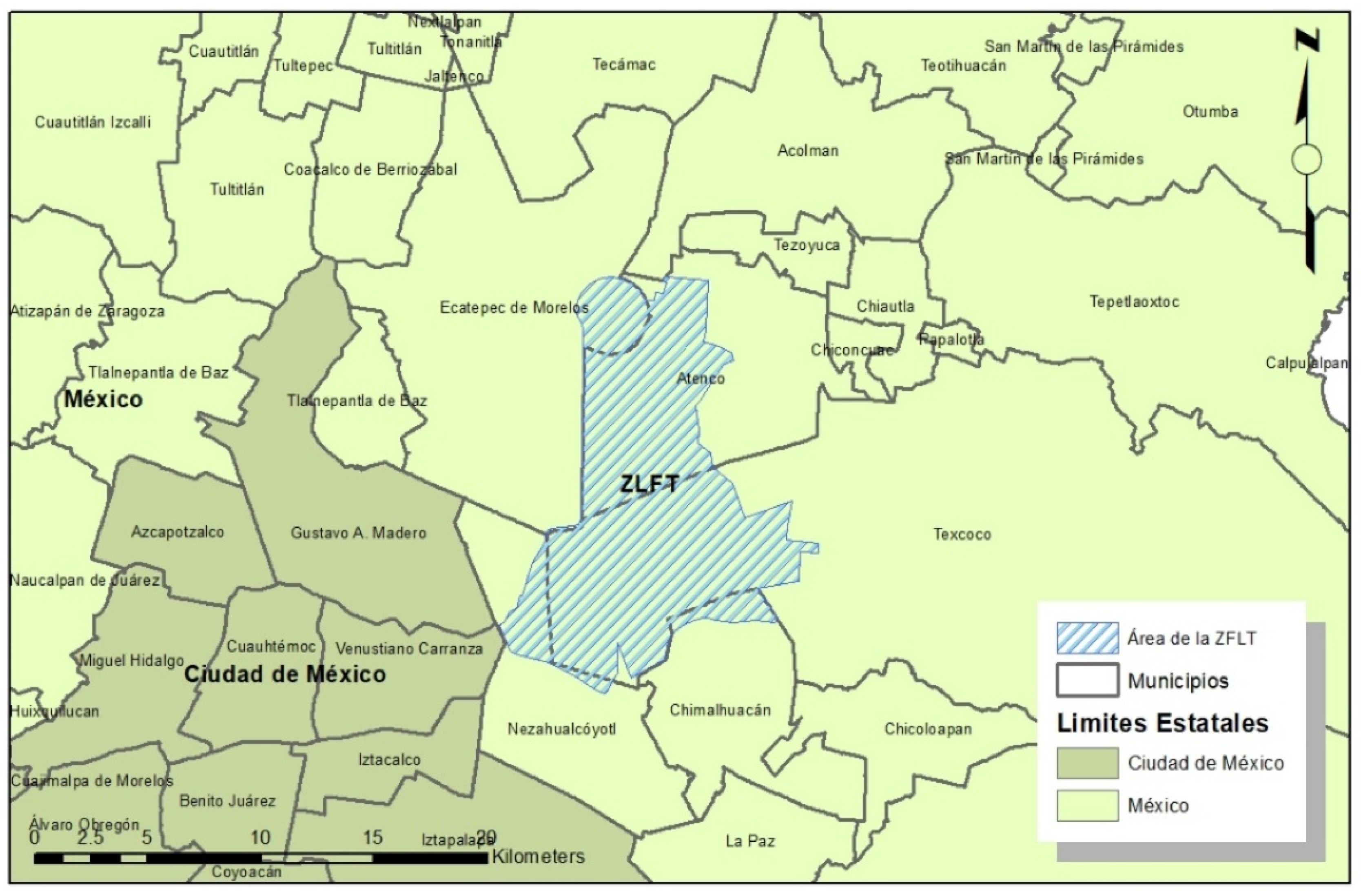
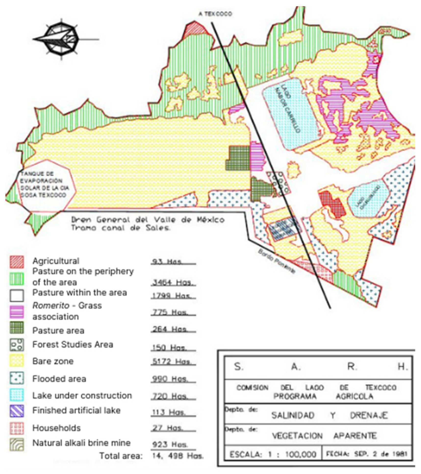
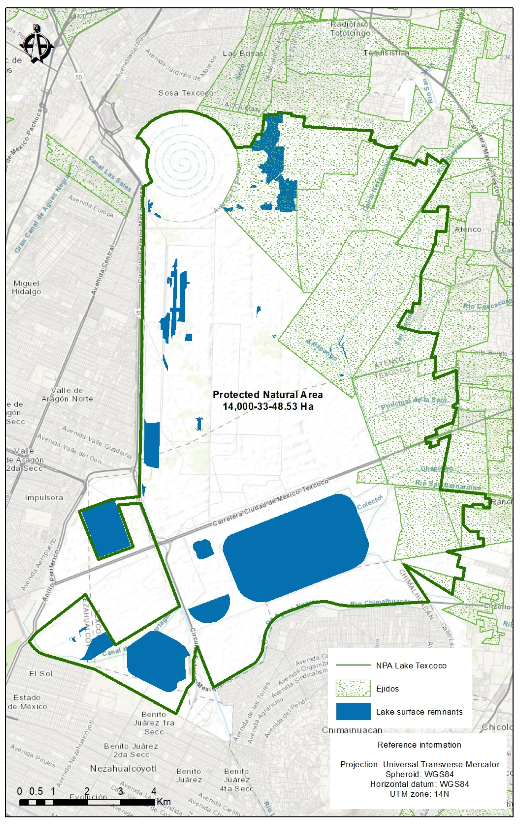