
Land Use Planning and Green Environment Services: The Contribution of Trail Paths to Sustainable Development


Abstract
:1. Introduction
2. Methodology and Analysis
2.1. Key Aspects and Considerations on the Jointly Reported “Land Use” AND “Environment” AND “Development” Keywords
2.1.1. Built-Natural Environment Interactions
2.1.2. Geospatial Technologies and Analyses
2.1.3. Land Use and Land Cover Considerations
2.1.4. The Unification of Land Use with Environment and Development in the Asian Geographical Context
2.2. Key Aspects and Considerations on the Jointly Reported “Trail Path” AND Subcategory of “Land” Keywords
2.3. Key Aspects and Considerations on the Jointly Reported “Land Use” AND “Sustainable Development” Keywords
2.4. Key Aspects and Considerations on the “Sustainable” AND “Trails” Keywords
- −
- cultural heritage of historic areas such as that of the historical core of Saida (Old Saida), Lebanon [84],
- −
- the Inca Trail passes in the northern frontier region of Ecuador where archaeological and historical tourism is considered a source of income and culture, incorporating and creating important cultural and natural tourism locations as well as an infrastructure that could generate income for the communities through revaluation [85].
- −
- relating natural spaces to mental health among university communities where trail systems allow students to interact with nature without having to leave the area [86],
- −
- the paddle-trail-related literature and the many different funding options to manage the creation and maintenance of paddle trails for paddle sports (e.g., kayaking and canoeing) [87],
- −
- the transnational hiking trail via Carpathia connecting seven European countries and promoting an ecologically compatible landscape and infrastructure development, offering sound possibilities to revisit leisure time activities, in alignment with international encounters, natural experiences and the maintenance and further enhancement of the regional cultural heritage [88].
3. Results
4. Discussion
5. Conclusions, Concerns and Future Research Orientations
Funding
Informed Consent Statement
Data Availability Statement
Conflicts of Interest
References
- Han, J.; Qian, X. Impacts of the development on land use and the water environment. In Sustainable Water Management: New Perspectives, Design, and Practices; Springer: Berlin/Heidelberg, Germany, 2016; pp. 143–155. [Google Scholar] [CrossRef]
- Huang, C.; Zhang, M.; Zou, J.; Zhu, A.-X.; Chen, X.; Mi, Y.; Wang, Y.; Yang, H.; Li, Y. Changes in land use, climate and the environment during a period of rapid economic development in Jiangsu Province, China. Sci. Total Environ. 2015, 536, 173–181. [Google Scholar] [CrossRef]
- Mcgranahan, D.A.; Thomson, K.J. Environment, land use and amenities—The new dimension of rural development environment. EuroChoices 2008, 7, 30–37. [Google Scholar] [CrossRef]
- Wang, X.-B.; Cai, D.-X.; Hoogmoed, W.B.; Oenema, O.; Perdok, U.D. Potential Effect of Conservation Tillage on Sustainable Land Use: A Review of Global Long-Term Studies1 1 Project supported by the National Natural Science Foundation of China (No. 40571151), the Beijing Key Lab of Resources Environment and GIS at Capital Normal University, and the National High Technology Research and Development Program of China (863 Program). Pedosphere 2006, 16, 587–595. [Google Scholar] [CrossRef]
- Das, G.G. Land Use, Land Cover, and Food-Energy-Environment Trade-Off: Key Issues and Insights for Millennium Devel-opment Goals. In Encyclopedia of Agriculture and Food Systems; Van Alfen, N.K., Ed.; Elsevier: Amsterdam, The Netherlands, 2014; pp. 114–133, Chapter 4; ISBN 9780080931395. [Google Scholar] [CrossRef]
- Hasibuan, H.S.; Moersidik, S.; Koestoer, R.; Soemardi, T.P. Using GIS to integrate the analysis of land-use, transportation, and the environment for managing urban growth based on transit oriented development in the metropolitan of Jabodetabek, Indonesia. IOP Conf. Ser. Earth Environ. Sci. 2014, 18, 012177. [Google Scholar] [CrossRef]
- Gasiorowski, J.; Poławski, Z.F. Land use structure as the basis for indicators determining spatial development of the environment. Pol. J. Environ. Stud. 2014, 23, 955–960. [Google Scholar]
- Mead, S.; Phillips, D.; Haggitt, T. Development of a geographic information system (GIS) to determine the vulnerability of regionally significant marine receiving environments to land-use impacts. In Proceedings of the 20th Australasian Coastal and Ocean Engineering Conference 2011 and the 13th Australasian Port and Harbour Conference, COASTS and PORTS 2011, Perth, Australia, 28–30 September 2011; pp. 763–768. [Google Scholar]
- Li, Y.; Long, H.; Liu, Y. Industrial development and land use/cover change and their effects on local environment: A case study of Changshu in eastern coastal China. Front. Environ. Sci. Eng. China 2010, 4, 438–448. [Google Scholar] [CrossRef]
- Van Der Vlist, M.J. Land use planning in the Netherlands; finding a balance between rural development and protection of the environment. Landsc. Urban Plan. 1998, 41, 135–144. [Google Scholar] [CrossRef]
- Xiao, S.; Huang, X.; Peng, B. Coordinative development between land use change and regional Population-Resources-Environment-Development system—A case study of Jiangsu Province. Chin. Geogr. Sci. 2007, 17, 289–296. [Google Scholar] [CrossRef]
- Nwafor, J.C. Physical environment, decision-making and land use development in Metropolitan Lagos. GeoJournal 1986, 12, 433–442. [Google Scholar] [CrossRef]
- Sneath, D. Land use, the environment and development in post-socialist Mongolia. Oxf. Dev. Stud. 2003, 31, 441–459. [Google Scholar] [CrossRef]
- Alrawi, A.K.; Qasim, S.S. Urban Management of City Centers the Road to the Sustainable Development (Sustainable Land Use Management). IOP Conf. Ser. Earth Environ. Sci. 2022, 961, 012090. [Google Scholar] [CrossRef]
- Thinh, N.X.; Arlt, G.; Heber, B.; Hennersdorf, J.; Lehmann, I. Evaluation of urban land-use structures with a view to sustainable development. Environ. Impact Assess. Rev. 2002, 22, 475–492. [Google Scholar] [CrossRef]
- Bruff, G.E.; Wood, A.P. Local sustainable development: Land-use planning’s contribution to modern local government. J. Environ. Plan. Manag. 2000, 43, 519–539. [Google Scholar] [CrossRef]
- Das, K.K.; Islam, R.; Ghosh, M. Harmonizing Natural and Built Environments: Integrating Wetlands in Land-Use Planning for Sustainable Development—A Case Study of Ananya R/A, Chittagong. Int. J. Soc. Ecol. Sustain. Dev. 2022, 13, 14. [Google Scholar] [CrossRef]
- Bridhikitti, A.; Ketuthong, A.; Prabamroong, T.; Li, R.; Li, J.; Liu, G. How Do Sustainable Development-Induced Land Use Change and Climate Change Affect Water Balance? A Case Study of the Mun River Basin, NE Thailand. Water Resour. Manag. 2022; in press. [Google Scholar] [CrossRef]
- Kusumadewi, T.; Husna, A.Z. Evaluation of land use at third campus development of uin maulana malik ibrahim malang with low impact development (LID) for environment sustainability. Adv. Environ. Biol. 2015, 9, 219–223. [Google Scholar]
- Meshgi, A.; Schmitter, P.; Chui, T.F.M.; Babovic, V. Development of a modular streamflow model to quantify runoff contributions from different land uses in tropical urban environments using Genetic Programming. J. Hydrol. 2015, 525, 711–723. [Google Scholar] [CrossRef]
- Van den Bossche, J.; De Baets, B.; Verwaeren, J.; Botteldooren, D.; Theunis, J. Development and evaluation of land use regression models for black carbon based on bicycle and pedestrian measurements in the urban environment. Environ. Model. Softw. 2018, 99, 58–69. [Google Scholar] [CrossRef]
- Navin Ganesh, V.; Sathyanarayan Sridhar, R. Land-use change detection and assessment for sustainable development of peri-urban areas using remote sensing and gis: A case study of Coimbatore city, Tamil Nadu, India. J. Environ. Prot. Ecol. 2020, 21, 2229–2244. [Google Scholar]
- Hamdanis Saam, Z.; Siregar, S.; Mubarak. Land use control model towards sustainable development of the city of Bangkinang. J. Adv. Res. Dyn. Control Syst. 2020, 12, 540–546. [Google Scholar] [CrossRef]
- Geitner, C.; Baruck, J.; Freppaz, M.; Godone, D.; Grashey-Jansen, S.; Gruber, F.E.; Heinrich, K.; Papritz, A.; Simon, A.; Stanchi, S.; et al. Soil and Land Use in the Alps-Challenges and Examples of Soil-Survey and Soil-Data Use to Support Sustainable Development. In Soil Mapping and Process Modeling for Sustainable Land Use Management; Elsevier: Amsterdam, The Netherlands, 2017; pp. 221–292. [Google Scholar] [CrossRef]
- Abdelfattah, M.A. Integrated Suitability Assessment: A Way Forward for Land Use Planning and Sustainable Development in Abu Dhabi, United Arab Emirates. Arid Land Res. Manag. 2013, 27, 41–64. [Google Scholar] [CrossRef]
- Nobre, C.A.; Sampaio, G.; Borma, L.S.; Castilla-Rubio, J.C.; Silva, J.S.; Cardoso, M. Land-use and climate change risks in the Amazon and the need of a novel sustainable development paradigm. Proc. Natl. Acad. Sci. USA 2016, 113, 10759–10768. [Google Scholar] [CrossRef]
- Majorai, R.; Jussila, H.; Delgado-Cravidao, F. Environment and Marginality in Geographical Space: Issues of Land Use, Territorial Marginalization and Development at the Dawn of New Millennium; Routledge: London, UK, 2017; 310p. [Google Scholar] [CrossRef]
- Bielecka, E.; Calka, B. Towards sustainable development exemplified by monitoring land use efficiency in Europe using SDG 11.3.1. Misc. Geogr. 2022, 26, 208–214. [Google Scholar] [CrossRef]
- Cao, M.; Chang, L.; Ma, S.; Zhao, Z.; Wu, K.; Hu, X.; Gu, Q.; Lu, G.; Chen, M. Multi-Scenario Simulation of Land Use for Sustainable Development Goals. IEEE J. Sel. Top. Appl. Earth Obs. Remote Sens. 2022, 15, 2119–2127. [Google Scholar] [CrossRef]
- Estoque, R.C.; Ooba, M.; Togawa, T.; Hijioka, Y.; Murayama, Y. Monitoring global land-use efficiency in the context of the UN 2030 Agenda for Sustainable Development. Habitat Int. 2021, 115, 102403. [Google Scholar] [CrossRef]
- Niens, J.; Bögeholz, S. Health and land-use courses of action for education for sustainable development in Madagascar: Teacher perspectives on possibilities for implementation. Sustainability 2021, 13, 13308. [Google Scholar] [CrossRef]
- Niens, J.; Richter-Beuschel, L.; Stubbe, T.C.; Bögeholz, S. Procedural knowledge of primary school teachers in madagascar for teaching and learning towards land-use-and health-related sustainable development goals. Sustainability 2021, 13, 9036. [Google Scholar] [CrossRef]
- Arifeen, H.M.; Phoungthong, K.; Mostafaeipour, A.; Yuangyai, N.; Yuangyai, C.; Techato, K.; Jutidamrongphan, W. Determine the land-use land-cover changes, urban expansion and their driving factors for sustainable development in gazipur Bangladesh. Atmosphere 2021, 12, 1353. [Google Scholar] [CrossRef]
- Jalilov, S.-M.; Chen, Y.; Quang, N.H.; Nguyen, M.N.; Leighton, B.; Paget, M.; Lazarow, N. Estimation of urban land-use efficiency for sustainable development by integrating over 30-year landsat imagery with population data: A case study of ha long, Vietnam. Sustainability 2021, 13, 8848. [Google Scholar] [CrossRef]
- Ntanos, S.; Kyriakopoulos, G.L.; Arabatzis, G.; Palios, V.; Chalikias, M. Environmental behavior of secondary education students: A case study at central Greece. Sustainability 2018, 10, 1663. [Google Scholar] [CrossRef]
- Gibas, P.; Majorek, A. Analysis of land-use change between 2012–2018 in Europe in terms of sustainable development. Land 2020, 9, 20. [Google Scholar] [CrossRef]
- Nae, M.; Dumitrache, L.; Suditu, B.; Matei, E. Housing activism initiatives and land-use conflicts: Pathways for participatory planning and urban sustainable development in Bucharest City, Romania. Sustainability 2019, 11, 6211. [Google Scholar] [CrossRef]
- García-Ruiz, J.M.; Lasanta, T.; Ruiz-Flano, P.; Ortigosa, L.; White, S.; González, C.; Martí, C. Land-use changes and sustainable development in mountain areas: A case study in the Spanish Pyrenees. Landsc. Ecol. 1996, 11, 267–277. [Google Scholar] [CrossRef]
- Llorca, C.; Silva, C.; Kuehnel, N.; Moreno, A.T.; Zhang, Q.; Kii, M.; Moeckel, R. Integration of land use and transport to reach sustainable development goals: Will radical scenarios actually get us there? Sustainability 2020, 12, 9795. [Google Scholar] [CrossRef]
- Hülsmann, S.; Jampani, M. A Nexus Approach for Sustainable Development: Integrated Resources Management in Resilient Cities and Multifunctional Land-Use Systems; Springer: Berlin/Heidelberg, Germany, 2020; 270p. [Google Scholar] [CrossRef]
- Hinz, R.; Sulser, T.B.; Huefner, R.; Mason-D’Croz, D.; Dunston, S.; Nautiyal, S.; Ringler, C.; Schuengel, J.; Tikhile, P.; Wimmer, F.; et al. Agricultural Development and Land Use Change in India: A Scenario Analysis of Trade-Offs Between UN Sustainable Development Goals (SDGs). Earth’s Future 2020, 8, 2019EF001287. [Google Scholar] [CrossRef]
- Christensen, M.; Arsanjani, J.J. Stimulating implementation of sustainable development goals and conservation action: Predicting future land use/cover change in Virunga national park, Congo. Sustainability 2020, 12, 1570. [Google Scholar] [CrossRef]
- Liu, L.; Liang, Y.; Hashimoto, S. Integrated assessment of land-use/coverage changes and their impacts on ecosystem services in Gansu Province, northwest China: Implications for sustainable development goals. Sustain. Sci. 2020, 15, 297–314. [Google Scholar] [CrossRef]
- Foster, S. Is UN Sustainable Development Goal 15 relevant to governing the intimate land-use/groundwater linkage? Hydrogeol. J. 2018, 26, 979–982. [Google Scholar] [CrossRef]
- Hassen, G.; Bantider, A.; Legesse, A.; Maimbo, M.; Likissa, D. Land Use and Land Cover Change for Resilient Environment and Sustainable Development in the Ethiopian Rift Valley Region. Ochr. Srodowiska I Zasobow Nat. 2021, 32, 24–41. [Google Scholar] [CrossRef]
- Messerli, P.; Bader, C.; Hett, C.; Epprecht, M.; Heinimann, A. Towards a spatial understanding of trade-offs in sustainable development: A meso-scale analysis of the nexus between land use, poverty, and environment in the Lao PDR. PLoS ONE 2015, 10, 0133418. [Google Scholar] [CrossRef]
- Liu, R.; Dong, X.; Zhang, P.; Zhang, Y.; Wang, X.; Gao, Y. Study on the sustainable development of an arid basin based on the coupling process of ecosystem health and human wellbeing under land use change-a case study in the manas river Basin, Xinjiang, China. Sustainability 2020, 12, 1201. [Google Scholar] [CrossRef]
- Zou, L.; Liu, Y.; Wang, J.; Yang, Y.; Wang, Y. Land use conflict identification and sustainable development scenario simulation on China’s southeast coast. J. Clean. Prod. 2019, 238, 117899. [Google Scholar] [CrossRef]
- Wang, W.; Wu, A.M.; Ye, F. Land use reforms: Towards sustainable development in China. In Fiscal Underpinnings for Sustainable Development in China: Rebalancing in Guangdong; Springer: Berlin/Heidelberg, Germany, 2017; pp. 29–51. [Google Scholar] [CrossRef]
- Wang, J.; Yang, Y.; Huang, L.; Wang, L. Sustainable development model and simulation for yellow river delta based on land use information. Open Cybern. Syst. J. 2014, 8, 638–644. [Google Scholar] [CrossRef]
- Wei, Y.D.; Ye, X. Urbanization, land use, and sustainable development in China. Stoch. Environ. Res. Risk Assess. 2014, 28, 755. [Google Scholar] [CrossRef]
- Rong, X.H.; Li, C.X.; Zhang, X.Y. Study on the land use structure in Xuzhou city for its sustainable development. Appl. Mech. Mater. 2013, 409–410, 52–55. [Google Scholar] [CrossRef]
- Reidsma, P.; Feng, S.; van Loon, M.; Luo, X.; Kang, C.; Lubbers, M.; Kanellopoulos, A.; Wolf, J.; Van Ittersum, M.K.; Qu, F. Integrated assessment of agricultural land use policies on nutrient pollution and sustainable development in Taihu Basin, China. Environ. Sci. Policy 2012, 18, 66–76. [Google Scholar] [CrossRef]
- Dong, R.; Xu, H.; Gou, Y.; Fu, X.; Wu, G. Analysis of land-use scenarios for urban sustainable development: A case study of Lijiang City. Int. J. Sustain. Dev. World Ecol. 2011, 18, 486–491. [Google Scholar] [CrossRef]
- Reidsma, P.; König, H.; Feng, S.; Bezlepkina, I.; Nesheim, I.; Bonin, M.; Sghaier, M.; Purushothaman, S.; Sieber, S.; van Ittersum, M.K.; et al. Methods and tools for integrated assessment of land use policies on sustainable development in developing countries. Land Use Policy 2011, 28, 604–617. [Google Scholar] [CrossRef]
- Liu, Y.; Liu, J.; Deng, K. A sustainable development based land use assessment for freeway construction. In Proceedings of the 7th Conference on Traffic and Transportation Studies, ICTTS, Kunming, China, 3–5 August 2010; Volume 383, pp. 37–46. [Google Scholar] [CrossRef]
- Pant, A.P. Nepals legal initiatives on land use for sustainable development. In Land Use Law for Sustainable Development; Cambridge University Press: Cambridge, UK, 2006; pp. 417–432. [Google Scholar] [CrossRef]
- Jiang, Z.; Wu, H.; Lin, A.; Shariff, A.R.M.; Hu, Q.; Song, D.; Zhu, W. Optimizing the spatial pattern of land use in a prominent grain-producing area: A sustainable development perspective. Sci. Total Environ. 2022, 843, 156971. [Google Scholar] [CrossRef]
- Zhang, S.; Chen, Y. Study on environmental performance assessment of the sustainable development of agricultural land use. J. Environ. Prot. Ecol. 2022, 23, 3426–3432. [Google Scholar]
- Moore, J.C. The re-imagining of a framework for agricultural land use: A pathway for integrating agricultural practices into ecosystem services, planetary boundaries and sustainable development goals: This article belongs to Ambio’s 50th Anniversary Collection. Theme: Agricultural land use. Ambio 2021, 50, 1295–1298. [Google Scholar] [CrossRef]
- Gorlachuk, V.; Lazarieva, O.; Belinska, S.; Potapsky, Y.; Petryshche, O. Defining the measures to rationally manage the sustainable development of agricultural land use. East-Eur. J. Enterp. Technol. 2018, 4, 47–53. [Google Scholar] [CrossRef]
- Xu, J.; Barrett, B.; Renaud, F.G. Ecosystem services and disservices in the Luanhe River Basin in China under past, current and future land uses: Implications for the sustainable development goals. Sustain. Sci. 2022, 17, 1347–1364. [Google Scholar] [CrossRef] [PubMed]
- Alipbeki, O.; Alipbekova, C.; Sterenharz, A.; Toleubekova, Z.; Makenova, S.; Aliyev, M.; Mineyev, N. Analysis of land-use change in shortandy district in terms of sustainable development. Land 2020, 9, 147. [Google Scholar] [CrossRef]
- Schneider, F.; Feurer, M.; Lundsgaard-Hansen, L.M.; Myint, W.; Nuam, C.D.; Nydegger, K.; Oberlack, C.; Tun, N.N.; Zähringer, J.G.; Tun, A.M. Sustainable Development under Competing Claims on Land: Three Pathways Between Land-Use Changes, Ecosystem Services and Human Well-Being. Eur. J. Dev. Res. 2020, 32, 316–337. [Google Scholar] [CrossRef]
- Kalantari, Z.; Santos Ferreira, C.S.; Page, J.; Goldenberg, R.; Olsson, J.; Destouni, G. Meeting sustainable development challenges in growing cities: Coupled social-ecological systems modeling of land use and water changes. J. Environ. Manag. 2019, 245, 471–480. [Google Scholar] [CrossRef] [PubMed]
- Hilário, R.R.; de Toledo, J.J.; Mustin, K.; Castro, I.J.; Costa-Neto, S.V.; Kauano, É.E.; Eilers, V.; Vasconcelos, I.M.; Mendes-Junior, R.N.; Funi, C.; et al. The Fate of an Amazonian Savanna: Government Land-Use Planning Endangers Sustainable Development in Amapá, the Most Protected Brazilian State. Trop. Conserv. Sci. 2017, 10, 1940082917735416. [Google Scholar] [CrossRef]
- Alonso, J.; Rey, J.; Castro, P.; Guerra, C. GIS based land use planning and watershed monitoring as tools for sustainable development. WIT Trans. Ecol. Environ. 2007, 106, 205–214. [Google Scholar] [CrossRef]
- Hong, Z.; Yan, Z.; Liang, Z. Evaluating coordinated development among land use, natural environment and social-economic. In Proceedings of the International Conference on Management and Service Science, MASS, Wuhan, China, 16–18 September 2009; p. 5301832. [Google Scholar] [CrossRef]
- Sitzia, T.; Rizzi, A.; Cattaneo, D.; Semenzato, P. Designing recreational trails in a forest dune habitat using least-cost path analysis at the resolution of visitor sight distance. Urban For. Urban Green. 2014, 13, 861–868. [Google Scholar] [CrossRef]
- Kantartzis, A.; Lemonakis, P.; Malesios, C.; Daoutis, C.; Galatsidas, S.; Arabatzis, G. Attitudes and Views of Citizens Regarding the Contribution of the Trail Paths in Protection and Promotion of Natural Environment. Land 2022, 11, 1585. [Google Scholar] [CrossRef]
- Wilson, T.; Lovelace, R.; Evans, A.J. A Path toward the Use of Trail Users’ Tweets to Assess Effectiveness of the Environmental Stewardship Scheme: An Exploratory Analysis of the Pennine Way National Trail. Appl. Spat. Anal. Policy 2019, 12, 71–99. [Google Scholar] [CrossRef]
- Nam, S.; O’Reilly, K. The Path and the Pavement: (Pre)modern Landscapes of Ecotourism on the Jeju Olle Trail, South Korea. Soc. Nat. Resour. 2021, 34, 432–448. [Google Scholar] [CrossRef]
- Vera, I.; Wicke, B.; Lamers, P.; Cowie, A.; Repo, A.; Heukels, B.; Zumpf, C.; Styles, D.; Parish, E.; Cherubini, F.; et al. Land use for bioenergy: Synergies and trade-offs between sustainable development goals. Renew. Sustain. Energy Rev. 2022, 161, 112409. [Google Scholar] [CrossRef]
- Lu, X.; Zhang, Y.; Lin, C.; Wu, F. Analysis and comprehensive evaluation of sustainable land use in China: Based on sustainable development goals framework. J. Clean. Prod. 2021, 310, 127205. [Google Scholar] [CrossRef]
- Ackerschott, A.; Kohlhase, E.; Vollmer, A.; Hörisch, J.; von Wehrden, H. Steering of land use in the context of sustainable development: A systematic review of economic instruments. Land Use Policy 2023, 129, 106620. [Google Scholar] [CrossRef]
- O’Driscoll, C.; Crowley, F.; Doran, J.; McCarthy, N. Land-use mixing in Irish cities: Implications for sustainable development. Land Use Policy 2023, 128, 106615. [Google Scholar] [CrossRef]
- Wei, C.; Meng, J.; Zhu, L.; Han, Z. Assessing progress towards sustainable development goals for Chinese urban land use: A new cloud model approach. J. Environ. Manag. 2023, 326, 116826. [Google Scholar] [CrossRef]
- Song, W.; Cao, S.; Du, M.; Lu, L. Distinctive roles of land-use efficiency in sustainable development goals: An investigation of trade-offs and synergies in China. J. Clean. Prod. 2023, 382, 134889. [Google Scholar] [CrossRef]
- Peng, R.; Liu, T.; Cao, G. Valuating Multifunctionality of Land Use for Sustainable Development: Framework, Method, and Application. Land 2023, 12, 222. [Google Scholar] [CrossRef]
- Larbi, I. Land use-land cover change in the Tano basin, Ghana and the implications on sustainable development goals. Heliyon 2023, 9, 14859. [Google Scholar] [CrossRef]
- Ewane, E.B.; Deh-Nji, A.; Mfonkwet, N.Y.; Nkembi, L. Agricultural expansion and land use land cover changes in the Mount Bamboutos landscape, Western Cameroon: Implications for local land use planning and sustainable development. Int. J. Environ. Stud. 2023, 80, 186–206. [Google Scholar] [CrossRef]
- Vardopoulos, I. Adaptive Reuse for Sustainable Development and Land Use: A Multivariate Linear Regression Analysis Estimating Key Determinants of Public Perceptions. Heritage 2023, 6, 809–828. [Google Scholar] [CrossRef]
- Beeton, S. Sustainable tourism in practice: Trails and tourism. Critical management issues of multi-use trails. Tour. Hosp. Plan. Dev. 2006, 3, 47–64. [Google Scholar] [CrossRef]
- Al-hagla, K.S. Sustainable urban development in historical areas using the tourist trail approach: A case study of the Cultural Heritage and Urban Development (CHUD) project in Saida, Lebanon. Cities 2010, 27, 234–248. [Google Scholar] [CrossRef]
- Camuñez, J.A.; Lomas, K.R. The Inca Trail (Qhapac Ñan) as a Contribution to Sustainable Tourism in Ecuador. Chapter 34. In TSIE 2019: Technology, Sustainability and Educational Innovation (TSIE); Advances in Intelligent Systems and Computing Book Series (AISC, Volume 1110); Springer: Cham, Switzerland, 2020; pp. 406–420. [Google Scholar] [CrossRef]
- Wright, S.; Hatt, L.; More, C. Walking trails: A sustainable component of a healthy campus. Int. J. Interdiscip. Environ. Stud. 2016, 11, 15–25. [Google Scholar] [CrossRef]
- Kline, C.; Cardenas, D.; Duffy, L.; Swanson, J.R. Funding sustainable paddle trail development: Paddler perspectives, willingness to pay and management implications. J. Sustain. Tour. 2012, 20, 235–256. [Google Scholar] [CrossRef]
- Jaudas, J. The transnational hiking trail via carpatica: A concept for the sustainable development of the Carpathians. In Environmental Science and Engineering (Subseries: Environmental Science); Springer: Berlin/Heidelberg, Germany, 2013; pp. 493–496. [Google Scholar] [CrossRef]
- Storni, A.; de Paiva, P.M.V.; Bernal, R.; Peralta, N. Evaluation of the impact on fauna caused by the presence of ecotourists on trails of the mamirauá sustainable development reserve, Amazonas, Brazil. Tour. Hosp. Plan. Dev. 2007, 4, 25–32. [Google Scholar] [CrossRef]
- Marion, J.L.; Wimpey, J. Assessing the influence of sustainable trail design and maintenance on soil loss. J. Environ. Manag. 2017, 189, 46–57. [Google Scholar] [CrossRef]
- Costantino, C.; Mantini, N.; Benedetti, A.C.; Bartolomei, C.; Predari, G. Digital and Territorial Trails System for Developing Sustainable Tourism and Enhancing Cultural Heritage in Rural Areas: The Case of San Giovanni Lipioni, Italy. Sustainability 2022, 14, 13982. [Google Scholar] [CrossRef]
- Cerveny, L.K.; Derrien, M.M.; Meyer, C.; Miller, A.B. Four dimensions of sustainable governance for National Scenic Trails. J. Outdoor Recreat. Tour. 2022, 39, 100518. [Google Scholar] [CrossRef]
- Mayr, B.; Beck, M.; Eisenberger, L.; Venek, V.; Kranzinger, C.; Menzl, A.; Reich, B.; Hornung-Prähauser, V.; Oberhoffer-Fritz, R.; Böhm, B.; et al. Valorization of Natural Cardio Trekking Trails Through Open Innovation for the Promotion of Sustainable Cross-generational Health-Oriented Tourism in the Connect2Move Project: Protocol for a Cross-sectional Study. JMIR Res. Protoc. 2022, 11, 39038. [Google Scholar] [CrossRef]
- Saaty, M.; Patel, J.V.; Abdelgawad, N.; McCrickard, D.S.; Marion, J.; Misra, S.; Wernstedt, K. Note: Studying Sustainable Practices of Appalachian Trail Community based on Reddit Topic Modelling Analysis. In ACM International Conference Proceeding Series 2022, Par F180472; Association for Computing Machinery: New York, NY, USA, 2022; pp. 560–563. [Google Scholar] [CrossRef]
- Mills, R. Active history: Creating sustainable cities through heritage trails. In Proceedings of the 2021 IEEE European Technology and Engineering Management Summit, E-TEMS 2021—Conference Proceedings, Dortmund, Germany, 18 March 2021; pp. 131–135. [Google Scholar] [CrossRef]
- Lukoseviciute, G.; Pereira, L.N.; Panagopoulos, T. Sustainable recreational trail design from the recreational opportunity spectrum and trail user perception: A case study of the Seven Hanging Valleys. J. Ecotourism 2021, 1–22. [Google Scholar] [CrossRef]
- Campbell, T.; Kirkwood, L.; McLean, G.; Torsius, M.; Florida-James, G. Trail use, motivations, and environmental attitudes of 3780 European mountain bikers: What is sustainable? Int. J. Environ. Res. Public Health 2021, 18, 12971. [Google Scholar] [CrossRef] [PubMed]
- Hemanth, K.V.; Jain, M.; Singh, I.; Chundeli, F.A. An Assessment of Turahalli Mountain Biking Trail Using Sustainable Trailing Design Guidelines of IMBA. J. Inst. Eng. Ser. A 2021, 102, 841–849. [Google Scholar] [CrossRef]
- Ribet, S.; Brander, L.M. Willingness to pay of trail runners for sustainable country park use in Hong Kong. J. Outdoor Recreat. Tour. 2020, 31, 100320. [Google Scholar] [CrossRef]
- Barthod-Prothade, M.; Leroux, E. Sustainable tourism in the Corsican mountains: The mare to mares trail. Worldw. Hosp. Tour. 2020, 12, 431–439. [Google Scholar] [CrossRef]
- Meadema, F.; Marion, J.L.; Arredondo, J.; Wimpey, J. The influence of layout on Appalachian Trail soil loss, widening, and muddiness: Implications for sustainable trail design and management. J. Environ. Manag. 2020, 257, 109986. [Google Scholar] [CrossRef]
- Stender, K.; Sanders, D.; Dowling, R. Sustainable long-distance trail management: International perspectives. Tour. Anal. 2018, 23, 365–376. [Google Scholar] [CrossRef]
- Kvasnička, T. Sustainable trails as solutions for land management. In Proceedings of the Public Recreation and Landscape Protection—With Nature Hand in Hand? Conference Proceeding, Brno, Czech Republic, 1–3 May 2018; pp. 331–335. [Google Scholar]
- Nomura, H.; Hong, N.B.; Yabe, M. Effective use and management of Kunisaki Peninsula Usa GIAHS long trail-A sustainable tourism model leading to regional development. Sustainability 2018, 10, 497. [Google Scholar] [CrossRef]
- Babí, J.; Inglés, E.; Soler, S. Trail races in protected mountain areas and their effects on sustainable development. Eco.Mont 2019, 11, 18–26. [Google Scholar] [CrossRef]
- Samie, A.; Deng, X.; Jia, S.; Chen, D. Scenario-Based Simulation on Dynamics of Land-Use-Land-Cover Change in Punjab Province, Pakistan. Sustainability 2017, 9, 1285. [Google Scholar] [CrossRef]
- Akpinar, N.; Talay, I.; Gun, S. Priority setting in agricultural land-use types for sustainable development. Renew. Agric. Food Syst. 2005, 20, 136–147. [Google Scholar] [CrossRef]
- Kuzmich, N.P. Sustainable development of the land use system in the agricultural sector. IOP Conf. Ser. Earth Environ. Sci. 2022, 1112, 012016. [Google Scholar] [CrossRef]
- Achayo Were, P.T. The development of road transport in Africa and its effects on land use and environment. Ind. Environ. 1983, 6, 25–26. [Google Scholar]
- Mittlefehldt, S. The people’s path: Conflictand cooperation in the acquisition of the Appalachian trail. Environ. Hist. 2010, 15, 643–669. [Google Scholar] [CrossRef]
- Bratton, S.P. The Spirit of the Appalachian Trail: Community, Environment, and Belief on a Long-Distance Hiking Path; Tombras School of Advertising and Public Relations: Knoxville, TN, USA, 2012; 284p. [Google Scholar]
- Phillips, S.H.; Leckman, P.O. Wandering the desert: Least cost path modeling for water transport trails in the Jornada Mogollon region, fort bliss, South-Central New Mexico. In Least Cost Analysis of Social Landscapes: Archaeological Case Studies; University of Utah Press: Salt Lake City, UT, USA, 2012; pp. 46–66. [Google Scholar]
- Sebos, I.; Progiou, A.G.; Kallinikos, L. Methodological Framework for the Quantification of GHG Emission Reductions from Climate Change Mitigation Actions. Strateg. Plan. Energy Environ. 2020, 39, 219–242. [Google Scholar] [CrossRef]
- Stankuniene, G.; Streimikiene, D.; Kyriakopoulos, G.L. Systematic literature review on behavioral barriers of climate change mitigation in households. Sustainability 2020, 12, 7369. [Google Scholar] [CrossRef]
- Nydrioti, I.; Katsiardi, P.; Chioti, D.; Sebos, I.; Assimacopoulos, D. Stakeholder mapping and analysis for climate change adaptation in Greece. Euro-Mediterr. J. Environ. Integr. 2022, 7, 339–346. [Google Scholar]
- Arabatzis, G.; Aggelopoulos, S.; Tsiantikoudis, S. Rural development and LEADER + in Greece: Evaluation of local action groups. Int. J. Food Agric. Environ. 2010, 8, 302–307. [Google Scholar]
- Tsiantikoudis, S.; Zafeiriou, E.; Kyriakopoulos, G.; Arabatzis, G. Revising the environmental Kuznets curve for deforestation: An empirical study for Bulgaria. Sustainability 2019, 11, 4364. [Google Scholar] [CrossRef]
- Moretti, A.; Pitas, C.; Christofi, G.; Bué, E.; Francescato, M.-G. Grid Integration as a Strategy of Med-TSO in the Mediterranean Area in the Framework of Climate Change and Energy Transition. Energies 2020, 13, 5307. [Google Scholar] [CrossRef]
- Di Gregorio, M.; Nurrochmat, D.R.; Paavola, J.; Sari, I.M.; Fatorelli, L.; Pramova, E.; Locatelli, B.; Brockhaus, M.; Kusumadewi, S.D. Climate policy integration in the land use sector: Mitigation, adaptation and sustainable development linkages. Environ. Sci. Policy 2017, 67, 35–43. [Google Scholar] [CrossRef]
- Zander, P.; Kächele, H. Modelling multiple objectives of land use for sustainable development. Agric. Syst. 1999, 59, 311–325. [Google Scholar] [CrossRef]


| Keyword # | Keyword Description | Keyword Title |
|---|---|---|
| 1 | Land Use OR Land Cover/Change/Planning/Erosion OR Trail | Land |
| 2 | Sustainable(-ity)/Rural Development/and Economy | Sustainability |
| 3 | Geography/Geospatial/GIS/and Spatial Analysis Scale/Remote Sensing | Spatial Geography |
| 4 | Environment(s)al Areas/Assessment/Change/Conditions/Effects/Factors/Legislation/Monitoring/Planning/Protection/Temperature AND National Park/Trails/Rural Roads/Trail Paths/Walking Paths | Environment |
| 5 | Agriculture/and Development/Land/and Alternative/Alpine/Cultural/Natural | Agriculture |
| 6 | Conservation OR Protection of Natural Resources/and Management | Conservation |
| 7 | Coordinated Development OR Recreation(-al) Facility OR Tourism OR Cycling OR Leisure | Facilities and Toursim and Leisure Activities |
| 8 | Human(s) Activity OR Heritage | Humans and Heritage |
| 9 | Forest(s) | Forestry |
| 10 | Hydrodynamic(s) Modelling/Characteristics OR Hydrology(ic)(al) Cycle(s) | Hydrology |
| 11 | Europe OR Eurasia/Asia | Continental Europe OR Asia |
| 12 | Water Accounting(s)/and Footprint/Virtual Water/Management/Planning/Policy(-ies)/Scarcity/Resource Management | Water |
| 13 | Climate/and Change/Environment | Climate |
| 14 | Development/Degree/Policy | Development |
| 15 | Carbon/and Dioxide/Sequestration/Footprint | Carbon |
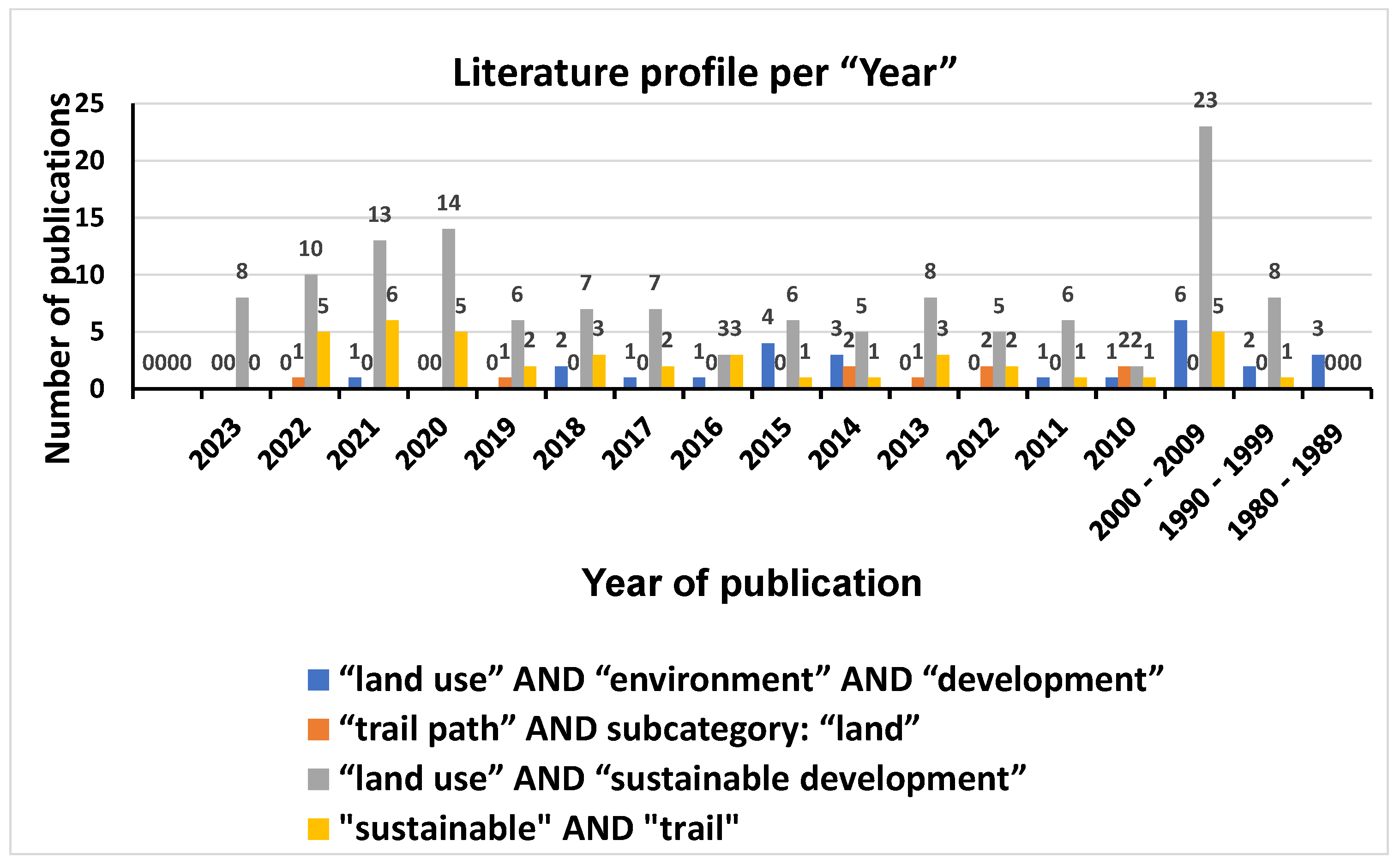
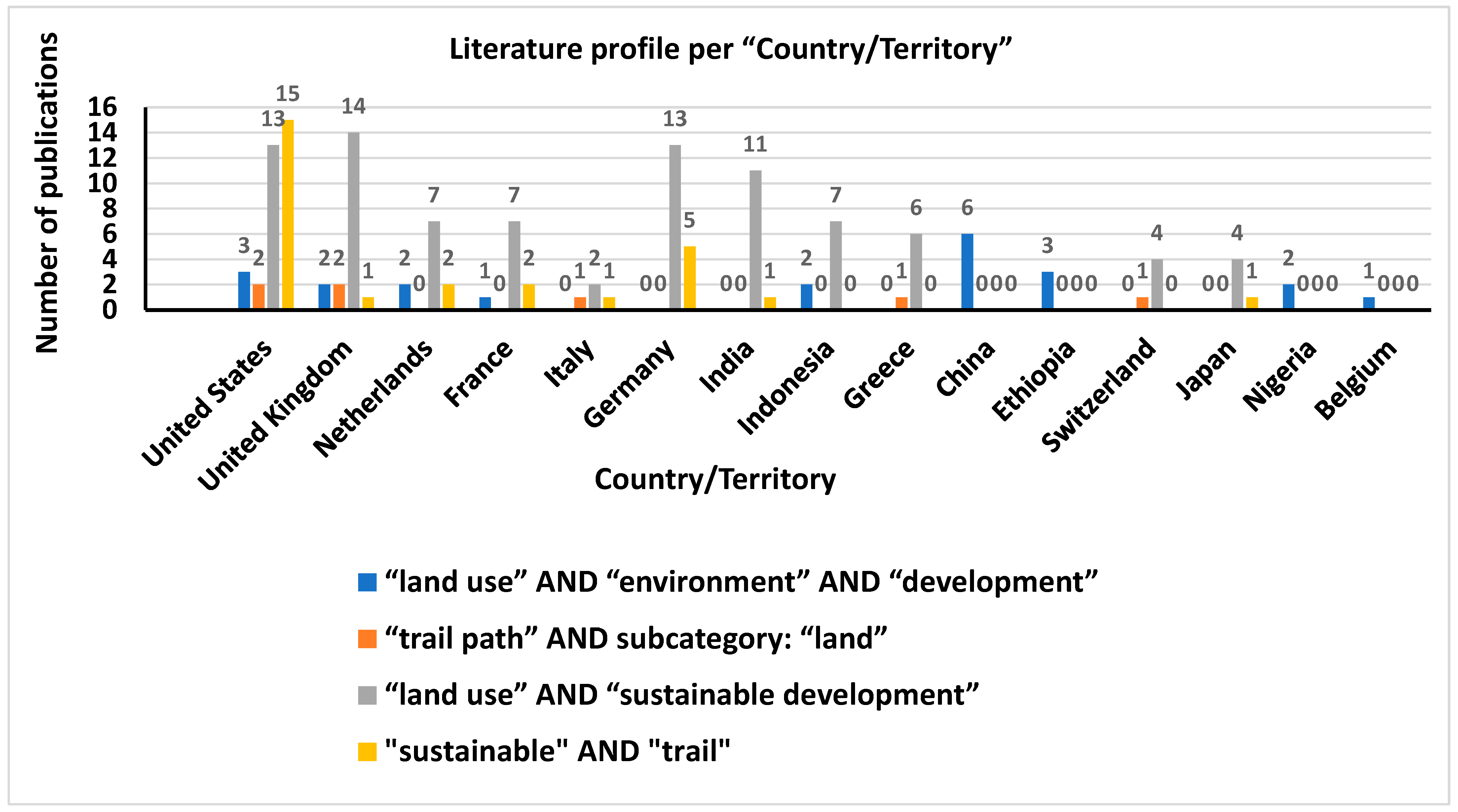
| 2 Domains | Year | Country/Territory | ||||||
|---|---|---|---|---|---|---|---|---|
| 4 fields of keywords | “land use” AND “sustainable development” | “land use” AND “environment” AND “development” | “sustainable” AND “trail” | “trail path” AND subcategory: “land” | “land use” AND “sustainable development” | “land use” AND “environment” AND “development” | “sustainable” AND “trail” | “trail path” AND subcategory: “land” |
| Total number of publications (documents) | 131 | 25 | 41 | 9 | 88 | 22 | 28 | 7 |
| Intensity ratios | 5.24 | 4.56 | 4.00 | 4.00 | ||||
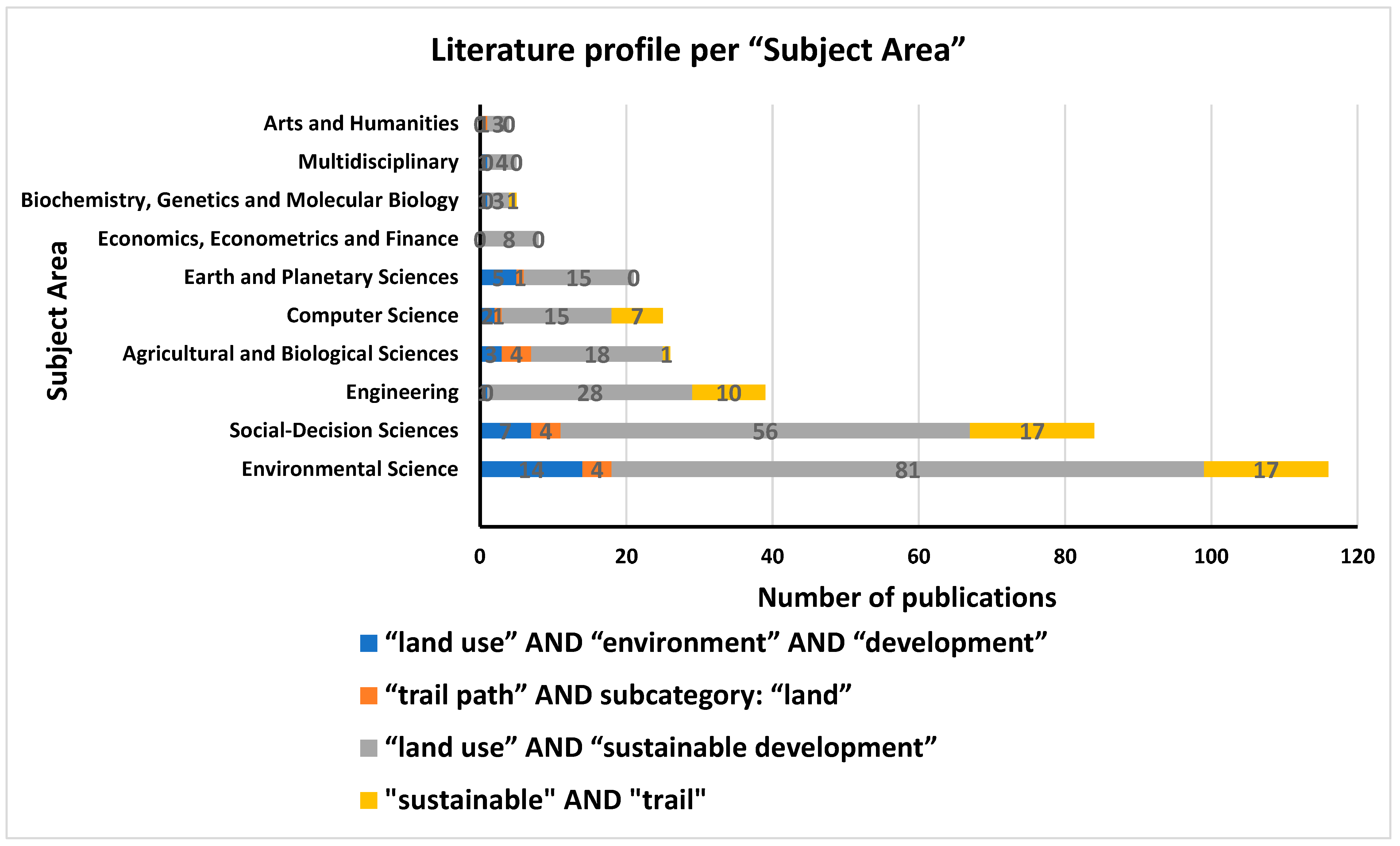
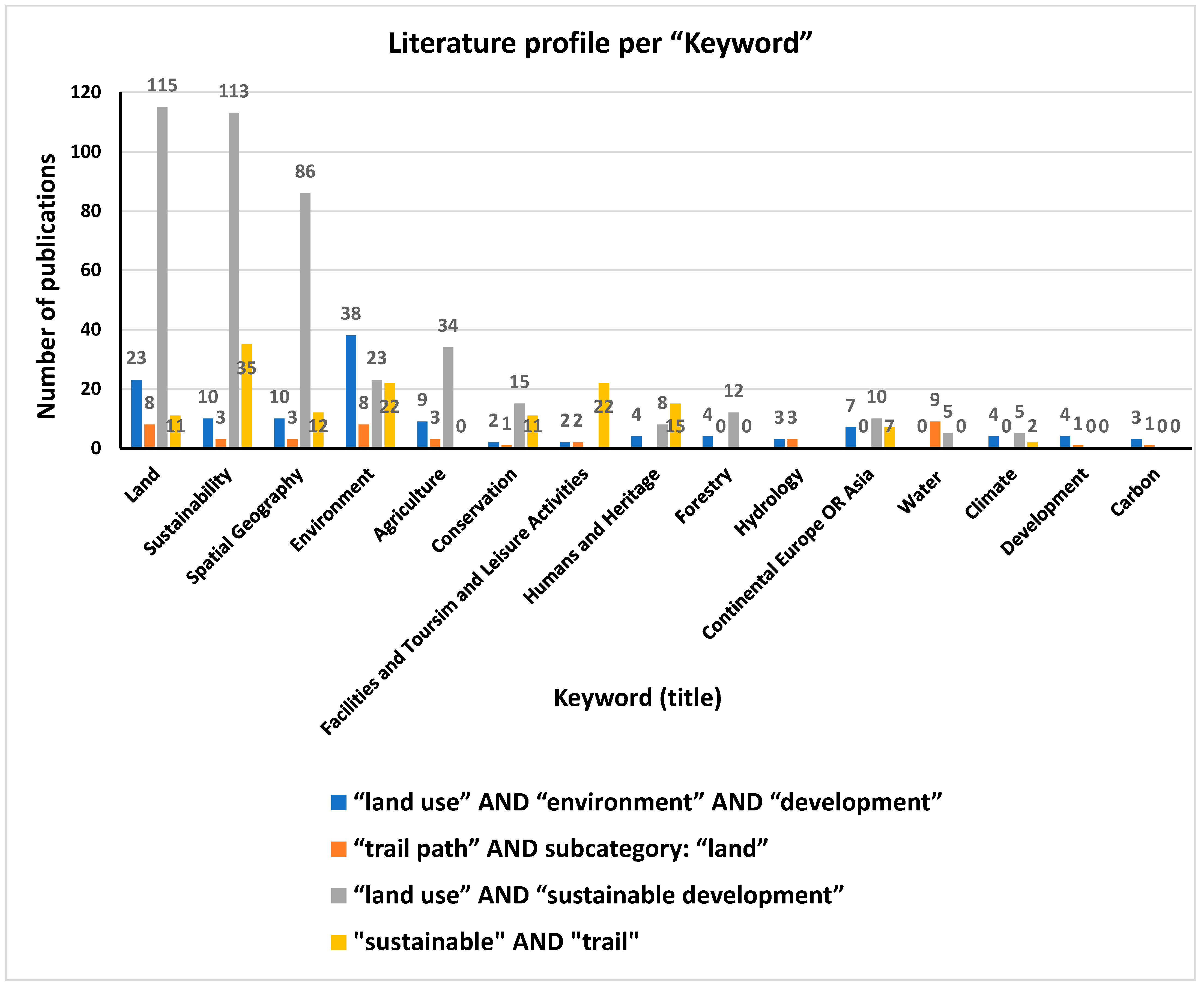
| 2 Domains | Subject Area | Keyword | ||||||
|---|---|---|---|---|---|---|---|---|
| 4 fields of keywords | “land use” AND “sustainable development” | “land use” AND “environment” AND “development” | “sustainable” AND “trail” | “trail path” AND subcategory: “land” | “land use” AND “sustainable development” | “land use” AND “environment” AND “development” | “sustainable” AND “trail” | “trail path” AND subcategory: “land” |
| Total number of publications (documents) | 231 | 34 | 53 | 15 | 426 | 123 | 137 | 42 |
| Intensity ratios | 6.79 | 3.53 | 3.46 | 3.26 | ||||
Disclaimer/Publisher’s Note: The statements, opinions and data contained in all publications are solely those of the individual author(s) and contributor(s) and not of MDPI and/or the editor(s). MDPI and/or the editor(s) disclaim responsibility for any injury to people or property resulting from any ideas, methods, instructions or products referred to in the content. |
© 2023 by the author. Licensee MDPI, Basel, Switzerland. This article is an open access article distributed under the terms and conditions of the Creative Commons Attribution (CC BY) license (https://creativecommons.org/licenses/by/4.0/).
Share and Cite
Kyriakopoulos, G.L. Land Use Planning and Green Environment Services: The Contribution of Trail Paths to Sustainable Development. Land 2023, 12, 1041. https://doi.org/10.3390/land12051041
Kyriakopoulos GL. Land Use Planning and Green Environment Services: The Contribution of Trail Paths to Sustainable Development. Land. 2023; 12(5):1041. https://doi.org/10.3390/land12051041
Chicago/Turabian StyleKyriakopoulos, Grigorios L. 2023. "Land Use Planning and Green Environment Services: The Contribution of Trail Paths to Sustainable Development" Land 12, no. 5: 1041. https://doi.org/10.3390/land12051041