
Periphery and Integrated Planning: Coping with Rural and Touristic Challenges across Scales in the German Wadden Sea Region
 , , , and
Abstract
:1. Introduction
2. Materials and Methods
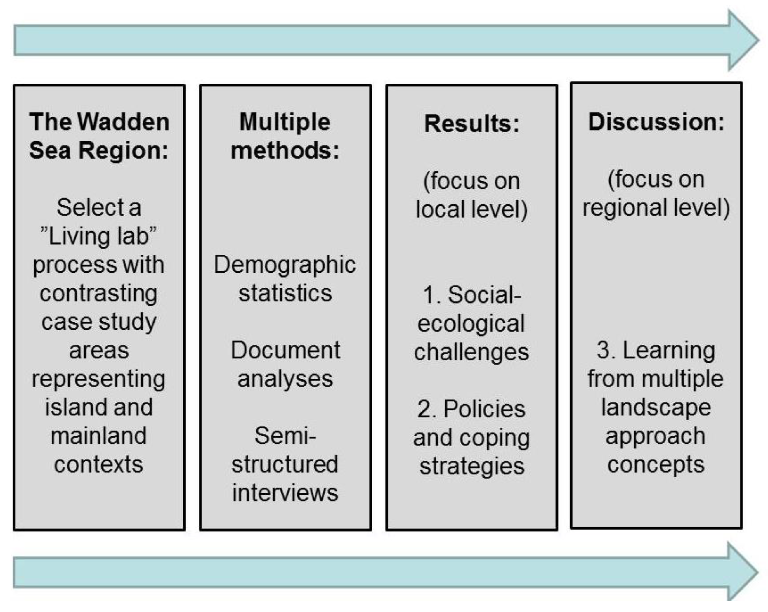
2.1. Overview of Methodology
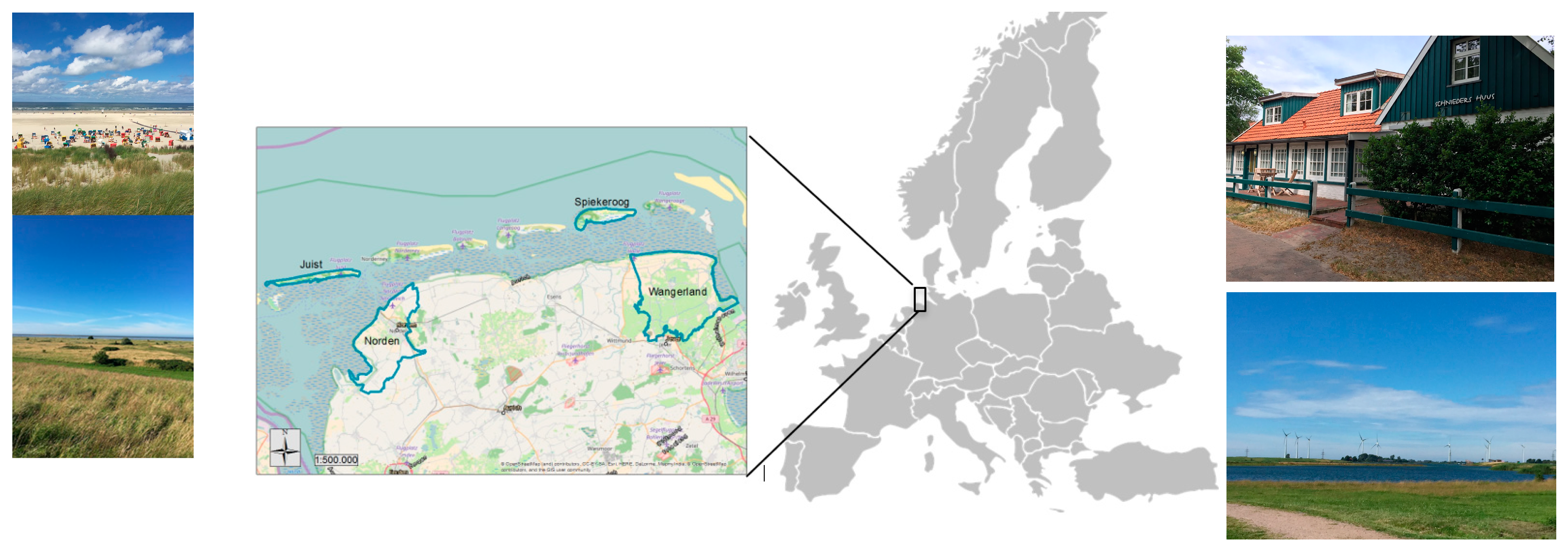
2.2. Case Study Areas
2.3. Methods
3. Results
3.1. An Overview of Perceived Challenges on Islands vs. Mainland
3.2. Key Challenges for Rural Development
3.2.1. Infrastructural and Structural Factors
3.2.2. Local Public Services and Social Cohesion
3.2.3. Challenges in Tourism and Their Relation to Demographic Changes
3.2.4. Lack of Skilled Labor
3.2.5. Territorial Challenges
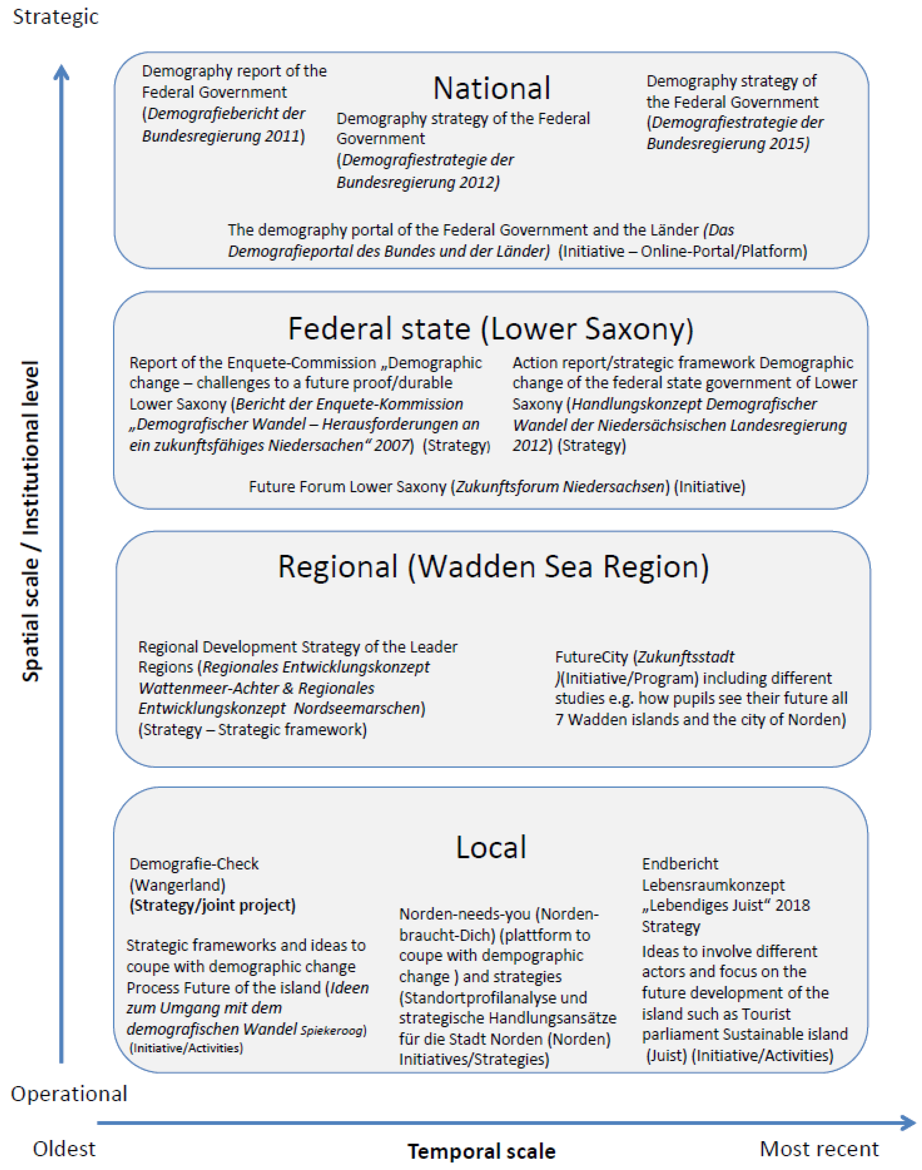
3.3. Policies and Coping Strategies at Different Scales
4. Discussion
4.1. Rural and Touristic Challenges
4.2. Policies and Decision Makers’ Coping Strategies
4.3. Landscape Approaches in the Wadden Sea Region
4.3.1. The Living Lab Approach
4.3.2. Other Landscape Approaches
World Heritage Site
Biosphere Reserve
LTSER Platform
4.3.3. Integrating Landscape Approaches

| Criterion (Inspired by [83]) | General Framework ([79]) | General Framework ([70]) | Living Lab ([31,32,34,35]) | World Heritage Site (the Five “Cs” (underlined); [89]) | Biosphere Reserve ([69]) | LTSER Platform ([72,73,74]) |
|---|---|---|---|---|---|---|
| A. Landscape as space |
|
|
|
|
|
|
| B. Infrastructure |
|
|
|
|
|
|
| C. Gyroscope (sustainable development as a societal process in a landscape as place) |
|
|
|
|
|
|
| D. Compass (states and trends of sustainability) |
|
|
|
|
|
|
5. Conclusions
Author Contributions
Funding
Institutional Review Board Statement
Informed Consent Statement
Data Availability Statement
Acknowledgments
Conflicts of Interest
References
- Keuschnigg, M.; Mutgan, S.; He dström, P. Urban scaling and the regional divide. Sci. Adv. 2019, 5, eaav0042. [Google Scholar] [CrossRef] [PubMed]
- Niedomysl, T. Residential Preferences for Interregional Migration in Sweden: Demographic, Socioeconomic, and Geographical Determinants. Environ. Plan. A Econ. Space 2008, 40, 1109–1131. [Google Scholar] [CrossRef]
- Lundholm, E. Returning home? Migration to birthplace among mi-grants after age 55. Popul. Space Place 2012, 18, 74–84. [Google Scholar] [CrossRef]
- Sievänen, T.; Edwards, D.; Fredman, P.; Jensen, F.S.; Vistad, O.I. (Eds.) Social Indicators in the Forest Sector in Northern Europe: A Review Focusing on Na-Ture-Based Recreation and Tourism; Nordic Council of Ministers: Copenhagen, Denmark, 2013. [Google Scholar]
- Eimermann, M. Promoting Swedish countryside in the Netherlands: International rural place marketing to attract new residents. Eur. Urban Re-Gional Stud. 2015, 22, 398–415. [Google Scholar] [CrossRef]
- Schouten, M.; van der Heide, C.M.; Heijman, W. Resilience of Social-Ecological Systems in European Rural Areas: Theory and Prospects. EAAE 13th Congress. In Proceedings of the European Association of Agricultural Economists (EAAE) 113th Seminar, Belgrade, Serbia, 9–11 December 2009. [Google Scholar] [CrossRef]
- Van Eupen, M.; Metzger, M.J.; Pérez-Soba, M.; Verburg, P.H.; Van Doorn, A.; Bunce, R.G.H. A rural typology for strategic European policies. Land Use Policy 2012, 29, 473–482. [Google Scholar] [CrossRef]
- Angelstam, P.; Andersson, K.; Annerstedt, M.; Axelsson, R.; Elbakidze, M.; Garrido, P.; Grahn, P.; Jönsson, K.I.; Pedersen, S.; Schlyter, P.; et al. Solving problems in social–ecological systems: Definition, practice and barriers of transdisciplinary research. Ambio 2013, 42, 254–265. [Google Scholar] [CrossRef] [PubMed]
- Duckett, D.; Feliciano, D.; Martin-Ortega, J.; Munoz-Rojas, J. Tackling wicked environmental problems: The discourse and its influence on practice in Scot-land. Landsc. Urban Plan. 2016, 154, 44–56. [Google Scholar] [CrossRef]
- Tietjen, A.; Jørgensen, G. Translating a wicked problem: A strategic planning approach to rural shrinkage in Denmark. Landsc. Urban Plan. 2016, 154, 29–43. [Google Scholar] [CrossRef]
- Küpper, P. Abgrenzung und Typisierung ländlicher Räume. Braunschweig: Johann Heinrich von Thünen-Institut, 53 p, Thünen Working Paper 68. Braunschweig, Germany. 2016. Available online: https://literatur.thuenen.de/digbib_extern/dn057783.pdf (accessed on 28 March 2023).
- United Nations, Department of Economic and Social Affairs, Population Division. World Population Prospects: The 2015 Revision; United Nations: New York, NY, USA, 2015. [Google Scholar]
- Kabat, P.; Bazelmans, J.; van Dijk, J.; Herman, P.M.J.; van Oijen, T.; Pejrup, M.; Reise, K.; Speelman, H.; Wolff, W.J. The Wadden Sea Region: Towards a science for sustainable development. Ocean. Coast. Manag. 2012, 68, 4–17. [Google Scholar] [CrossRef]
- Sijtsma, F.J.; Mehnen, N.; Angelstam, P.; Muños-Rojaz, J. Multi-scale mapping of cultural ecosystem services in a socio-ecological landscape: A case study of the international Wadden. Landsc. Ecol. 2019, 34, 1751–1768. [Google Scholar] [CrossRef]
- Sijtsma, F.J.; Daams, M.N.; Farjon, H.; Buijs, A.E. Deep feelings around a shallow coast. A spatial analysis of tourism jobs and the attractivity of nature in the Dutch Waddenarea. Ocean. Coast. Manag. 2012, 68, 138–148. [Google Scholar] [CrossRef]
- Van Dijk, J.; Broersma, L.; Mehnen, N. Options for socioeconomic developments in ICZM for the tri-national Wadden area. Ocean. Coast. Manag.-Ment 2016, 119, 76–92. [Google Scholar] [CrossRef]
- Noss, R.F. A regional landscape approach to maintain diversity. Bio-science 1983, 33, 700–706. [Google Scholar] [CrossRef]
- Milder, J.C.; Buck, L.E.; DeClerck, F.A.J.; Scherr, S.J. Landscape Ap-proaches to Achieving Food Production, Natural Resource Conservation, and the Mil-lenium Development Goals. In Integrating Ecology and Poverty Reduction; Ingram, J.C., DeClerck, F.A.J., Del Rumbaitis Rio, C., Eds.; Springer: New York, NY, USA, 2010; pp. 77–108. [Google Scholar]
- Arts, B.; Buizer, M.; Horlings, L.; Ingram, V.; Van Oosten, C.; Opdam, P. Landscape approaches: A state-of-the-art review. Annu. Rev. Environ.-Ment Resour. 2017, 42, 439–463. [Google Scholar] [CrossRef]
- Estrada-Carmona, N.; Hart, A.K.; DeClerck, F.A.J.; Harvey, C.A.; Milder, J.C. Integrated landscape management for agriculture, rural livelihoods, and ecosys-tem conservation: An assessment of experience from Latin America and the Caribbean. Landsc Urban Plan 2014, 129, 1–11. [Google Scholar] [CrossRef]
- Reed, J.; Deakin, L.; Sunderland, T. What are ‘Integrated Landscape Approaches’ and how effectively have they been implemented in the tropics: A sys-tematic map protocol. Environ. Evid. 2015, 4, 2. [Google Scholar] [CrossRef]
- Sayer, J.; Margules, C.; Boedhihartono, A.K.; Dale, A.; Sunderland, T.; Su-priatna, J.; Saryanthi, R. Landscape approaches: What are the pre-conditions for success? Sustain. Sci. 2015, 10, 345–355. [Google Scholar] [CrossRef]
- Angelstam, P.; Elbakidze, M.; Axelsson, R.; Khoroshev, A.; Tysiachniouk MPedroli, B.; Tysiachniouk, M.; Zabubenin, E. Model Forests in Russia as landscape approach: Demonstration projects or initiatives for learning towards sustainable forest management? For. Policy Econ. 2019, 101, 96–110. [Google Scholar] [CrossRef]
- Lähteenmäki-Smith, K. (Ed.) Learning through Evaluation: The Nordic Experience; Nordregio Report; Nordregio: Stockholm, Sweden, 2007; Volume 3, ISBN 978-91-89332-64-5. Available online: http://norden.diva-portal.org/smash/get/diva2:700399/FULLTEXT01.pdf (accessed on 28 March 2023).
- Porter, E.J.; Davoudi, S. A bridging concept or a dead end? Plan. Theory Pract. 2012, 13, 329–333. [Google Scholar] [CrossRef]
- ESPON. Policy Brief Inner Peripheries in Europe. Possible Development Strategies to Overcome Their Marginalising Effects. 2020. Available online: https://www.espon.eu/sites/default/files/attachments/ESPON-Policy-Brief-Inner-Peripheries.pdf (accessed on 28 March 2023).
- Heslinga, J.H.; Groote, P.; Vanclay, F. Using a social-ecological systems perspective to understand tourism and landscape interactions in coastal areas. J. Tour. Futures 2018, 3, 23–38. [Google Scholar] [CrossRef]
- Santos, V.; Sousa, M.J.; Costa, C.; Au-Yong-Oliveira, M. Tourism towards Sustainability and Innovation: A Systematic Literature Review. Sustainability 2021, 13, 11440. [Google Scholar] [CrossRef]
- Schaal, P. Die Jade und das Land am Jadebusen–Gebietsbeschreibung und–abgrenzung. In Oldenburger Landesverein für Geschichte, Natur- und Heimatkunde e.V. (OLV) und Biologische Schutzgemeinschaft Hunte Weser-Ems e.V (BSH). Die Jade–Flusslandschaft am Jadebusen; Isensee Verlag Oldenburg: Oldenburg, Germany, 2015; pp. 15–27. [Google Scholar]
- State Statistical Office of Lower Saxony (LSN). Bevölkerung nach Geschlecht; Fläche, Bevölkerungsdichte (Gemeinde; Zeitreihe). LSN-Online–Regionaldatenbank. 2019. Available online: https://www1.nls.niedersachsen.de/statistik/html/default.asp (accessed on 15 March 2019).
- Bergvall-Kåreborn, B.; Eriksson, C.I.; Ståhlbröst, A.; Svensson, J. A Milieu for Innovation–Defining Living Labs. 2008. Available online: http://www.diva-portal.org/smash/get/diva2:1004774/FULLTEXT01.pdf (accessed on 17 March 2019).
- Almirall, E.; Lee, M.; Wareham, J. Mapping Living Labs in the Landscape of Innovation Methodologies. Technol. Innov. Manag. Rev. 2012, 2, 12–18. [Google Scholar] [CrossRef]
- EnoLL. 2005. Available online: http://www.openlivinglabs.eu/aboutus (accessed on 28 March 2023).
- Liedtke, C.; Baedeker, C.; Hasselkuß, M.; Rohn, H.; Grinewitschus, V. User-integrated innovation in Sustainable LivingLabs: An experimental infrastructure for researching and developing sustainable product service systems. J. Clean. Prod. 2015, 97, 106–116. [Google Scholar] [CrossRef]
- Schäfer, E. Living Labs–Ein Ansatz für die Innovation Klimaresilienter Infrastrukturen? Analyse des Living Lab Ansatzes auf der Grundlage des Forschungsstandes zum Klimawandel, Transformation Großtechnischer Systeme und Resilienz. Master’s Thesis, Carl von Ossietzky-Universität, Oldenburg, Germany, 2014. [Google Scholar]
- Schliwa, S.; Evans, J.; McCormick, K.; Voytenko, Y. Living Labs and Sustainability Transitions–Assessing the Impact of Urban Experimentation. In Proceedings of the Paper Presented at ‘Innovations in Climate Governance’, Helsinki, Finland, 12–13 March 2015. [Google Scholar]
- Dettmann, E.; Fackler, D.; Müller, S.; Neuschäffer, G.; Slavtchev, V.; Leber, U.; Schwengler, B. Fehlende Fachkräfte in Deutschland–Unterschiede in den Betrieben und mögliche Erklärungsfaktoren: Ergebnisse aus dem IAB-Betriebspanel 2018. In IAB Forschungsbericht 10/2019; Institut für Arbeitsmarkt- und Berufsforschung: Nürnberg, Germany, 2019. [Google Scholar]
- Kerr, S.A. What is small island sustainable development about? Ocean. Coast. Manag. 2005, 48, 503–524. [Google Scholar] [CrossRef]
- Faludi, A. Territorial cohesion: An unidentified political objective. Introduction to the special issue. Town Plan. Rev. 2005, 76, 1–13. [Google Scholar] [CrossRef]
- Federal Ministry of the Interior. Every Age Counts. 2013. Available online: https://www.bmi.bund.de/SharedDocs/downloads/EN/publikationen/demografiestrategie_englisch.html;jsessionid=83F02C695CA595D804A76FC6A2346104.1_cid287 (accessed on 20 July 2019).
- Federal Ministry of the Interior. Every Age Counts. Greater Prosperity and Better Quality of Life for All Generations. The Further Development of the Federal Government’s Demographic Strategy. 2016. Available online: https://www.bmi.bund.de/SharedDocs/downloads/EN/themen/demography/further-developement-demographic-strategy.pdf?__blob=publicationFileandv=1 (accessed on 20 July 2019).
- Federal Ministry of the Interior. Federal Government Report on the Demographic Situation and Future Development of Germany. 2011. Available online: https://www.bmi.bund.de/SharedDocs/downloads/EN/themen/demography/demografiebericht_kurz_en.pdf?__blob=publicationFileandv=1 (accessed on 20 July 2019).
- Brunken-Winkler, H.; Badewien, S.; Heine, A.-K.; Lange, T.; Nahrath, J.; Töben, K.; Klaucke, T.; Scheele, U.; Meier, M. Regionales Entwicklungskonzept der Region Nordseemarschen 2015–2021. Arbeitsgemeinschaft ARSU/NWP. Wattenmeer-Achter. 2015. Available online: http://nordseemarschen.tourismus-ostfriesland.de/wp-content/uploads/2015/10/REK-NSM.pdf (accessed on 20 July 2019).
- Niedersächsischer Landtag. Bericht der Enquete-Kommission Demografischer Wandel–Herausforderung an ein Zukunftsfähiges Niedersachsen. 2007. Available online: https://www.demografie-portal.de/SharedDocs/Downloads/DE/BerichteKonzepte/NI/Enquete_Kommission.pdf?__blob=publicationFileandv=1 (accessed on 21 April 2019).
- Niedersächsische Staatskanzlei. Handlungskonzept Demografischer Wandel Der Niedersächsischen Landesregierung 2012. 2012. Available online: www.niedersachsen.de/download/65785 (accessed on 21 April 2019).
- Brunken-Winkler, H.; Nahrath, J.; Lange, T.; Badewien, S.; Heine, A.-K.; Töben, K.; Klaucke, T.; Scheele, U.; Oberdörffer, J. Regionales Entwicklungskonzept für den “Wattenmeer-Achter” im WeltnaturerbeWattenmeer-Achter. Arbeitsgemeinschaft ARSU/NWP. Lokale Aktionsgruppe Nordseemarschen. 2015. Available online: https://www.wattenmeer-achter.de/landu/wp-content/uploads/2014/10/Regionales-Entwicklungskonzept-Wattenmeer-Achter-.pdf (accessed on 20 July 2019).
- Bundesministerium für Bildung und Forschung (BMBF) (Undated). Zukunftsstadt. Available online: https://www.bmbf.de/de/zukunftsstadt-566.html (accessed on 20 July 2019).
- Wattenmeer-Achter im Weltnaturerbe. 2015. Zukunftsstadt. Available online: https://wattenmeer-achter.de/zukunftsstadt/ (accessed on 15 March 2019).
- Foltin, M. Aus der Praxis eines Demografiebeauftragten: Bensheims Antwort auf den demografischen Wandel. Inf. Zur Raumentwickl. 2013, 2, 147–154. Available online: https://www.bbsr.bund.de/BBSR/DE/Veroeffentlichungen/IzR/2013/2/Inhalt/DL_Foltin.pdf?__blob=publicationFileandv=2 (accessed on 20 July 2019).
- Arbeitsgemeinschaft der Landkreise und kreisfreien Städte in Weser-Ems. Innovation in der Daseinsvorsorge. Masterplan Weser-Ems im Rahmen der “Wissensvernetzung Weser-Ems”. 2018. Available online: https://www.weser-ems.eu/export/sites/default/wissensregion/assets/dl-news/Masterplan-Daseinsvorsorge-Weser-Ems.pdf (accessed on 28 March 2023).
- Niedersächsische Landgesellschaft mbH (NLG). Integriertes Entwicklungs- und Handlungskonzept. Entwurf; Gemeindenetzwerk Wangerland Wangerooge Jever: Hannover, Germany, 2015. [Google Scholar]
- Federal Institute for Research on Building, Urban Affairs and Spatial Development. Demographic Prognoses: With Assumptions into the Future (Original Title: Demografische Prognosen: Per Annahme in die Zukunft); BBSR IzR1/2018: Bonn, Germany, 2018. [Google Scholar]
- Dijst, M.; Lanzendorf, M.; Barendregt, A.; Smit, L. Second homes in Germany and the Netherlands: Ownership and travel impact explained. Tijdschr. Voor Econ. En Soc. Geogr. 2005, 96, 139–152. [Google Scholar] [CrossRef]
- Wielenga, B. Shifting land use in German coastal mainland destina-tions: Historical development of tourism in Norden-Norddeich. J. Tour. Futures 2018, 4, 233–248. [Google Scholar] [CrossRef]
- Wang, Z.B.; Hoekstra, P.; Burchard, H.; Ridderinkhof, H.; De Swart, H.E.; Stive, M.J.F. Morphodynamics of the Wadden Sea and its barrier island system. Ocean. Coast. Manag. 2012, 68, 39–57. [Google Scholar] [CrossRef]
- Schaal, P. Climate Change Mitigation and Energy Concepts: Also an Issue for Rural Areas? Experiences of Communities in Northwest Germany. In European Rural Peripheries Revalued: Governance, Actors, Impacts; Grab-ski-Kieron, X.X., Mose, I., Steinführer, A., Reichert-Sick, A., Eds.; LIT-Verlag: Berlin, Germany, 2016; pp. 342–358. [Google Scholar]
- Enhance. Enhancing Risk Management Partnerships for Catastrophic Natural Disasters in Europe. Hamburg, Germany. 2017. Available online: https://www.gerics.de/imperia/md/content/csc/projekte/enhance1.pdf (accessed on 28 March 2023).
- Levin, K.; Cashore, B.; Bernstein, S.; Auld, G. Overcoming the tragedy of super wicked problems: Constraining our future selves to ameliorate global climate change. Policy Sci. 2012, 45, 123–152. [Google Scholar] [CrossRef]
- Grabski-Kieron, U.; Mose, I.; Reichert-Schick, A.; Steinführer, A. (Eds.) European Rural Peripheries Revalued. Governance, Actors, Impacts. (= Rural Areas: Issues of Local and Regional Development, Volume 1); LIT: Münster, Germany, 2016; ISBN 978-3-643-13050-1. [Google Scholar]
- Grimm, B.; Lohmann, M.; Heinsohn, K.; Richter, C.; Metzler, D. The impact of Demographic Change on Tourism and Conclusions for Tourism Policy. A Study Commissioned by the Federal Ministry of Economics and Technology. Abridged Ver-sion. Federal Ministry of Economics and Technology. 2009. Available online: http://sete.gr/files/Media/Ebook/2009/0907_GermanMinistryOfEconomics_DemographicChange.pdf (accessed on 1 February 2017).
- Mose, I.; Mehnen, N.; Jansen, H. Le isole Frisone orientali. Dal turismo di massa al turismo sostenibile? In Il Tesoro dell’Isola; Paci, D., Cacallo, F.L., Eds.; Ecoturismo e Insularità in Europa: Milano, Italy, 2021; pp. 69–90. [Google Scholar]
- Angelstam, P.; Fedoriak, M.; Cruz, F.; Muñoz-Rojas, J.; Yamelynets, T.; Manton, M.; Washbourne, C.-L.; Dobrynin, D.; Izakovičova, Z.; Jansson, N.; et al. Meeting places and social capital supporting rural landscape stewardship: A Pan-European horizon scanning. Ecol. Soc. 2021, 26, 11. [Google Scholar] [CrossRef]
- Ahlhorn, F.; Spiekermann, J.; Schaal, P.; Bormann, H.; Kebschull, J. Akteursbeteiligung bei der Anpassung des Entwässerungsmanagements im norddeutschen Küstenraum. Wasser Und Abfall 2018, 20, 28–35. [Google Scholar] [CrossRef]
- Giebels, D.; van Buuren AEdelenbos, J. Ecosystem-based management in the Wadden Sea: Principles for the governance of knowledge. J. Sea Res. 2013, 82, 176–187. [Google Scholar] [CrossRef]
- Arnstein, S.R. A ladder of citizen participation. J. Am. Inst. Plan. 1969, 35, 216–224. [Google Scholar] [CrossRef]
- Striegnitz, M. Conflicts over coastal protection in a National Park: Mediation and negotiated law making. Land Use Policy 2006, 23, 26–33. [Google Scholar] [CrossRef]
- Weixlbaumer, N.; Hammer, T.; Mose, I.; Siegrist, D. Das Biosphere Reserve-Konzept in Deutschland, Österreich und der Schweiz–Paradigmatische Entwicklung und zukünftige Herausforderungen im Spannungsfeld von Regionalentwicklung und globaler Nachhaltigkeit. In Biosphäre 4.0.; Borsdorf, A., Jungmeier, M., Braun, V., Heinrich, K., Eds.; UNESCO Biosphere Reserves als Modellregionen einer nachhaltigen Entwicklung: Berlin, Germany, 2020; pp. 99–120. [Google Scholar]
- EUROPARC Germany (EUROPARC Deutschland e.V.). Model regions of world standing-UNESCO Biosphere Reserves. 2007. Available online: https://www.nationalpark-wattenmeer.de/sites/default/files/media/pdf/unesco_biosphere_reserves.pdf (accessed on 28 March 2023).
- UNESCO. Biosphärenreservate. Die Sevilla-Strategie und die Internationalen Leitlinien für das Weltnetz; Bundesamt für Naturschutz: Bonn, Germany, 1996. [Google Scholar]
- Sayer, J.; Sunderland, T.; Ghazoul, J.; Pfund, J.L.; Sheil, D.; Meijaard, E.; Venter, M.; Boedhihartono, A.K.; Day, M.; Garcia, C.; et al. Ten principles for a landscape approach to reconciling ag-riculture, conservation, and other competing land uses. Proc. Natl. Acad. Sci. USA 2013, 110, 8349–8356. [Google Scholar] [CrossRef] [PubMed]
- Winkler, K.J.; Hauck, J. Landscape stewardship for a German UNESCO Biosphere Reserve: A network approach to establishing stewardship govern-ance. Ecol. Soc. 2019, 24, 12. [Google Scholar] [CrossRef]
- Haberl, H.; Winiwarter, V.; Andersson, K.; Ayres, R.U.; Boone, C.; Castillo, A.; Cunfer, G.; Fischer-Kowalski, M.; Freudenburg, W.R.; Furman, E.; et al. From LTER to LTSER: Conceptualizing the socioeconomic dimension of long-term socioecological research. Ecol. Soc. 2006, 11, 34. [Google Scholar] [CrossRef]
- Mirtl, M.; Frenzel, M.; Furman, E.; Ohl, C.; Krauze, K.; Grünbühel, C. LTER-EUROPE: Criteria and recommendations. Version 5.2, 2008-05-27. 2008. Available online: http://www.lter-europe.net/document-archive/central/I3034v02-LTER-Europe-Criteria.pdf (accessed on 28 March 2023).
- Grove, J.M.; Pickett, S.T.A.; Whitmer, A.; Cadenasso, M.L. Building and urban LTSER: The case of the Baltimore ecosystem study and the D.C./B.C., UL-TRA-Ex project. In Long Term Socio-Ecological Research Studies in Society Nature Interactions across Temporal and Spatial Scales; Singh, J.S., Haberl, H., Schmid, M., Mirtl, M., Chertow, M., Eds.; Springer: Dordrecht, The Netherlands, 2013; pp. 369–408. [Google Scholar]
- Singh, S.J.; Haberl, H.; Chertow, M.; Mirtl, M.; Schmid, M. Introduction. In Long Term So-Cio-Ecological Research: Studies in Society–Nature Interactions across Spatial and Temporal Scales; Singh, S.J., Haberl, H., Chertow, M., Mirtl, M., Schmid, M., Eds.; Springer: Dordrecht, The Netherlands, 2013; pp. 1–26. [Google Scholar]
- Bretagnolle, V.; Berthet, E.; Gross, N.; Gauffre, B.; Plumejeaud, C.; Houte, S.; Badenhausser, I.; Monceaua, K.; Allier, F.; Monestiez, P.; et al. Towards sus-tainable and multifunctional agriculture in farmland landscapes: Lessons from the integrative approach of a French LTSER platform. Sci. Total Environ. 2018, 627, 822–834. [Google Scholar] [CrossRef]
- Angelstam, P.; Manton, M.; Elbakidze, M.; Sijtsma, F.; Adamescu, M.; Avni, N.; Beja, P.; Bezak, P.; Zyablikova, I.; Cruz, F.; et al. LTSER platforms as a place-based transdisciplinary research infrastructure: Learning landscape approach through evaluation. Landsc. Ecol. 2019, 34, 1461–1484. [Google Scholar] [CrossRef]
- Meffe, G.K.; Nielsen, L.A.; Knight, R.L.; Schenborn, D.A. Ecosystem Management. Adaptive, Community-Based Conservation; Island Press: Washington, DC, USA, 2002. [Google Scholar]
- Axelsson, R.; Angelstam, P.; Elbakidze, M.; Stryamets, N.; Johansson, K.-E. Sustainable development and sustainability: Landscape approach as a practical interpretation of principles and implementation concepts. J. Landsc. Ecol. 2011, 4, 5–30. [Google Scholar] [CrossRef]
- Angelstam, P.; Munoz-Rojas, J.; Pinto-Correia, T. Landscape concepts and landscape approach can foster knowledge production and learning that sustain multiple ecosystem services. Landsc. Ecol. 2019, 34, 1445–1460. [Google Scholar] [CrossRef]
- World Forestry Congress. Forests in Development: A Vital Balance. 18–23 October 2009. World Forestry Congress Bulletin. Final Issue 10 (18). 2009. Available online: https://enb.iisd.org/events/xiii-world-forestry-congress-wfc-2009/summary-report-18-23-october-2009 (accessed on 28 March 2023).
- Freeman, O.E.; Duguma, L.A.; Minang, P.A. Operationalizing the integrated landscape approach in practice. Ecol. Soc. 2015, 20, 24. [Google Scholar] [CrossRef]
- Lee, K.N. Compass and Gyroscope: Integrating Science and Politics for the Environment; Island Press: Covelo, CA, USA, 1993. [Google Scholar]
- Puente-Rodríguez, D.; van Slobbe, E.; Al, I.A.; Lindenbergh, D.D. Knowledge co-production in practice: Enabling environmental management systems for ports through participatory research in the Dutch Wadden Sea. Environ. Sci. Policy 2016, 55, 456–466. [Google Scholar] [CrossRef]
- Kwiatkowski, G.; Hjalager, A.M.; Liburd, J.; Saabye Simonsen, P. Volunteering and collaborative governance innovation in the Wadden Sea National Park. Curr. Issues Tour. 2020, 23, 971–989. [Google Scholar] [CrossRef]
- Heslinga, J.; Groote, P.; Vanclay, F. Towards resilient regions: Policy recommendations for stimulating synergy between tourism and landscape. Land 2020, 9, 44. [Google Scholar] [CrossRef]
- Schepers, M.; Meijles, E.W.; Bakker, J.P.; Spek, T. A diachronic triangular perspective on landscapes: A conceptual tool for research and management applied to Wadden Sea salt marshes. Marit. Stud. 2021, 20, 235–254. [Google Scholar] [CrossRef]
- Deutsche Gesellschaft für Internationale Zusammenarbeit (GIZ) GmbH (2019): Landscape Approaches. Available online: https://www.giz.de/en/downloads/giz2020-0174en-landscape-approaches-background-paper.pdf (accessed on 3 March 2023).
- UNESCO World Heritage (n.d.). The World Heritage Convention. The five “Cs”. Available online: https://whc.unesco.org/en/convention (accessed on 3 March 2023).


| Island Municipalities | Mainland Municipalities | |||
|---|---|---|---|---|
| Spiekeroog | Juist | Norden | Wangerland | |
| Inhabitants | 806 | 1515 | 25,060 | 9190 |
| Area in km2 | 18 | 16 | 106 | 176 |
| Inhabitants per km2 | 44 | 92 | 236 | 52 |
| Average age | 43 | 45 | 47 | 48 |
| Foreigners (total) | 113 | 475 | 1958 | 325 |
| Net migration | 3 | −5 | 250 | −3 |
| Area/Field of Action | Percieved Challenges | Typical Periperal Rural | Typical Touristic | Mainland | Island | ||
|---|---|---|---|---|---|---|---|
| Wangerland | Norden | Spiekeroog | Juist | ||||
| Demography | Decline/change in population structure | X | X | X | |||
| Low number of young people | X | X | X | X | X | ||
| Out-migration of young people | X | X | X | X | X | ||
| In-migration of elderly | Y | Y | Y | ||||
| Competition among land uses | Settlements | Y | Y | Y | |||
| National Park restrictions | Y | Y | Y | ||||
| Agriculture vs. Tourism | Y | Y | |||||
| Economics | Lack of specialised workforce | X | Y | X | X | Y | Y |
| Only few jobs in academia | X | Y | X | X | Y | Y | |
| Dominance of tourism sector | Y | Y | Y | ||||
| General less attractive jobs | X | Y | X | Y | Y | ||
| High unemployment rate of younger people | X | X | |||||
| Public services and Public health sector | Poor recruitment of General Practitioners | X | X | X | X | ||
| No residential care for the elderly | X | X | X | ||||
| Difficult emergency medical services | X | X | X | ||||
| Civil society/social togetherness | Decrease of volunteers, societies, clubs | X | X | X | |||
| Losing local knowledge | X | X | X | ||||
| New inhabitants not interested in social life | Y | Y | Y | Y | Y | ||
| Need to strengthen participation of local inhabitants | X | X | X | X | X | ||
| Infrastructure facilities | Shortage of rental houses | Y | Y | Y | |||
| Infrastructure is not ready for demographic change | X | Y | X | Y | Y | ||
| Tough financial situation of municipalities | X | X | Y | ||||
| Investments are needed | X | Y | X | X | Y | Y | |
| “Brain-drain” | X | X | X | X | |||
| Total # Typical peripheral–rural challenges | 17 | 12/17 | 8/17 | 9/17 | 9/17 | ||
| Total # Typical touristic challenges | 12 | 3/12 | 2/12 | 11/12 | 10/12 | ||
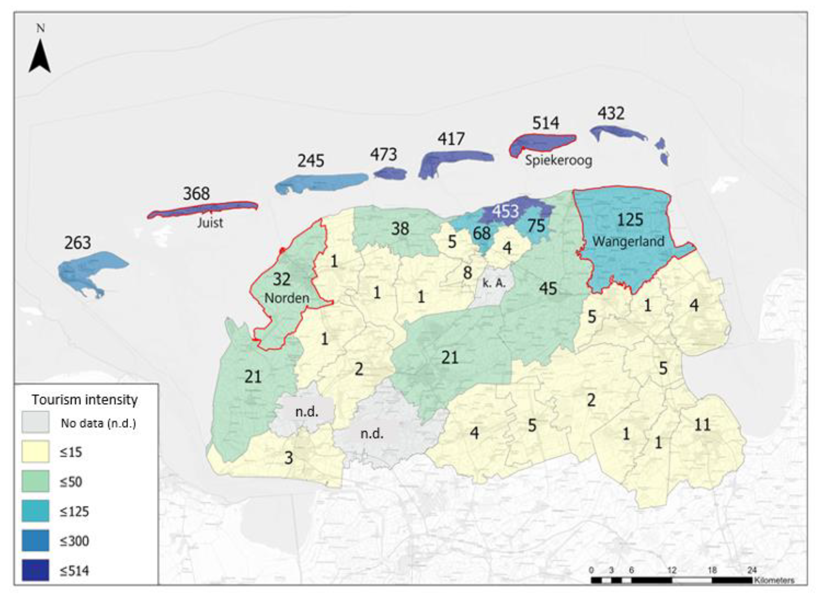
| Municipality | Inhabi- Tants | Tourists Per Inhabitant | Average Stay 1/365 of One Year | Average Stay 7/365 of One Year | |||
|---|---|---|---|---|---|---|---|
| Full Time Tourist Equivalents (FTTE) | FTTE Per Inhabitant | Full Time Tourist sEquivalents (FTTE) | FTTE Per Inhabitant | ||||
| Island | Spiekeroog | 805 | 745 | 1644 | 2.0 | 11,507 | 14.3 |
| Juist | 1522 | 263 | 1096 | 0.7 | 7671 | 5.0 | |
| Mainland | Norden | 25,056 | 32 | 2192 | 0.1 | 15,342 | 0.6 |
| Wangerland | 9275 | 129 | 3288 | 0.4 | 23,014 | 2.5 | |
Disclaimer/Publisher’s Note: The statements, opinions and data contained in all publications are solely those of the individual author(s) and contributor(s) and not of MDPI and/or the editor(s). MDPI and/or the editor(s) disclaim responsibility for any injury to people or property resulting from any ideas, methods, instructions or products referred to in the content. |
© 2023 by the authors. Licensee MDPI, Basel, Switzerland. This article is an open access article distributed under the terms and conditions of the Creative Commons Attribution (CC BY) license (https://creativecommons.org/licenses/by/4.0/).
Share and Cite
Mehnen, N.; Mose, I.; Schaal, P.; Sijtsma, F.; Muñoz-Rojas, J.; Fedoriak, M.; Angelstam, P. Periphery and Integrated Planning: Coping with Rural and Touristic Challenges across Scales in the German Wadden Sea Region. Land 2023, 12, 904. https://doi.org/10.3390/land12040904
Mehnen N, Mose I, Schaal P, Sijtsma F, Muñoz-Rojas J, Fedoriak M, Angelstam P. Periphery and Integrated Planning: Coping with Rural and Touristic Challenges across Scales in the German Wadden Sea Region. Land. 2023; 12(4):904. https://doi.org/10.3390/land12040904
Chicago/Turabian StyleMehnen, Nora, Ingo Mose, Peter Schaal, Frans Sijtsma, José Muñoz-Rojas, Mariia Fedoriak, and Per Angelstam. 2023. "Periphery and Integrated Planning: Coping with Rural and Touristic Challenges across Scales in the German Wadden Sea Region" Land 12, no. 4: 904. https://doi.org/10.3390/land12040904