Article

Is Obliterated Land Still Land? Tenure Security and Climate Change in Indonesia

by
Sukmo Pinuji
1,
Walter Timo de Vries
2,*,
Trisnanti Widi Rineksi
1 and
Wahyuni Wahyuni
1
1
Sekolah Tinggi Pertanahan Nasional, Yogyakarta 55293, Indonesia
2
Chair of Land Management, School of Engineering and Design, Technical University of Munich, 80333 Munich, Germany
*
Author to whom correspondence should be addressed.
Land 2023, 12(2), 478; https://doi.org/10.3390/land12020478
Submission received: 17 January 2023 / Revised: 10 February 2023 / Accepted: 13 February 2023 / Published: 15 February 2023
(This article belongs to the Special Issue Geospatial Data for Landscape Change)

Abstract

:
Both human activities and climate change have changed landscapes significantly, especially in coastal areas. Sea level rise and land subsidence foster tidal floods and permanent inundations, thus changing and limiting land use. Though many countries, including Indonesia, are aware of these phenomena, the legal status of this permanently inundated land remains unclear. Indonesia refers to this land legally as obliterated land. This qualification makes former landowners uncertain, as it does not recognize their previous land rights, and creates disputes during land acquisition. In view of policy pressures to develop large-scale projects, the government often fails to include obliterated land legally during land acquisition processes for these projects. This causes unfair and disputed compensation for those former landowners. Current scientific discourses do not yet address this legal quandary. This study therefore has the following three aims: (1) to describe the legal, institutional and procedural contradictions related to obliterated land; (2) to assess the validity of right of the owners whose land parcels are permanently inundated; and (3) to formulate a responsible and tenure responsive policy to deal with obliterated land. We investigate these questions for the construction of a toll road and sea embankment in Kecamatan Sayung, Kabupaten Demak involving obliterated land. We reviewed policies, regulations and documentations related to coastal land and disaster management, and the implementation of land acquisition. We used geospatial data to visualize the ways in which and locations where landscapes, land parcels and land right changed. We determined that legal uncertainty leads to policy inconsistencies in handling obliterated land, specifically during land acquisition. Additionally, former landowners suffer from the legal gaps to establish clarity of land tenure, which prevents them from receiving any compensation. We suggest a law revision that considers the social–historical aspects of land tenure when defining obliterated land. The law should also provide for a fairer and more just compensation for former landowners during land acquisition processes.

1. Introduction

Climate change, as well as human activity on land, have dramatically altered the world’s landscape including coastal areas. This region is one of the hardest-hit by climate change. It has impacted coastal areas in a variety of ways, including sea level rise, sea current changes, increased abrasion, and ecosystem destruction. It can also impact landscape alteration due to land subsidence, rise of sea level, sedimentation, and abrasion [1]. This will affect many aspects from the change in coastal ecosystem to the livelihood of people living in the surrounding area [2,3,4,5]. Climate change may also compel people to flee their homes owing to environmental degradation, making it impossible for them to live in the area [2,3]. The Intergovernmental Panel on Climate Change predicts a worldwide mean sea-level rise from 26 to 98 cm by year 2100. Given the continued growth of low-lying cities around the world, many of which are in coastal zones, sea-level rise will continue to exacerbate urban climate vulnerabilities in the future, including Indonesia [5]. As an archipelagic country with over 80,000 km of coastline, Indonesia is extremely vulnerable to climate change. According to the Indonesian National Statistical Bureau, approximately 42 million Indonesians live in areas less than 10 m above sea level, making them vulnerable in various ways. It is also estimated that by 2050, sea level rise will have submerged 2000 small islands, and approximately 42 million people will have lost their homes as a result of this occurrence [6]. It was also determined that the use of satellite altimetry to predict the trends of sea level rise in Indonesia reveals that the average rate in Indonesia is higher than the global average. It is estimates that Indonesia encountered a sea level rise of up to 3.9–0.4 mm/year between 1992 and 2020, which make Indonesia extremely vulnerable to climate change, especially in coastal area [7,8]. The trend of sea level rise seen by the Topex/Poseidon altimetry satellites, Jason 1, Jason 2, and Jason 5, over a 25-year period from 1993 to 2018 also shows a positive trend, indicating that it continues to rise. The annual rate of increase of 4.6 mm exceeds the world rate of rise of 3 mm [7,9].
Given the severity of the problem, extensive efforts to mitigate and adapt to the effects of climate change in coastal areas are critical. The degree to which climate change adaptation and risk management are mainstreamed into two fundamental parts of land governance, namely securing and preserving of land rights and planning and control of land use [10]. Many studies have proven that tenure security is closely related to resilience to climate change [5,11,12], as well as good spatial planning system [13,14].
Climate change can also produce physical and functional changes in the land due to abrasion, land subsidence, sea level rise, or, in some cases, improper spatial planning that may result in loss of land and displacement. Unfortunately, these events have occurred in a number of Indonesian coastal cities and will continue to be the main concern in the following years [15,16]. On the other hand, the coastal area is often exposed to center of development due to its strategic location. These are typically sites of rapid development and economic growth, making this threat more apparent as many coastal regions are at risk of losing or diminishing territory owing to these disasters. Here, we emphasize the need for responsible land governance and responsive tenure in safeguarding land rights and building climate resilience communities.
Many studies have been conducted to examine the relationship between tenure security and climate change adaptation, as well as the ways in which they interconnect and interact with one another [11,17]. Nonetheless, we determine that little research has been undertaken on tenure security response to land that has physically changed, or that has been submerged and inundated by sea water, and hence cannot function properly. How will this land be treated in terms of land law and regulation? What about the land right attached to it? What happens to those who were evicted from the neighborhood? Will the former landowner be paid for their loss? How should this be incorporated into the national development agenda? These questions in particular should be addressed from the beginning, either before or during the development of adaptation and mitigation measures [18], rather than focusing solely on post-disaster responses, as many developing countries did [19,20,21].
Using the example of permanent inundation in Kecamatan Sayung, Kabupaten Demak, Central Java Province, with a focus on the building of a toll road and sea embarkment on those submerged areas, we intend to (1) describe the legal, institutional and procedural contradictions related to obliterate land; (2) assess the validity of the rights of the owners whose land parcels are permanently inundated; and (3) formulate a responsible and tenure responsive policy to deal with obliterated land.
This research is critical because the study location has long been adversely impacted by the effects of climate change, but it was later identified to be a National Strategic Project location with an essential development agenda for the country. The complexity of the relationship between national interests, tenure certainty, and environmental protection is an excellent instance of the issues to be addressed in this research. Furthermore, because many coastal locations in Indonesia have been experiencing similar situations for a long time, we believe that our research will be critical in providing scientific discussion in addressing this issue.

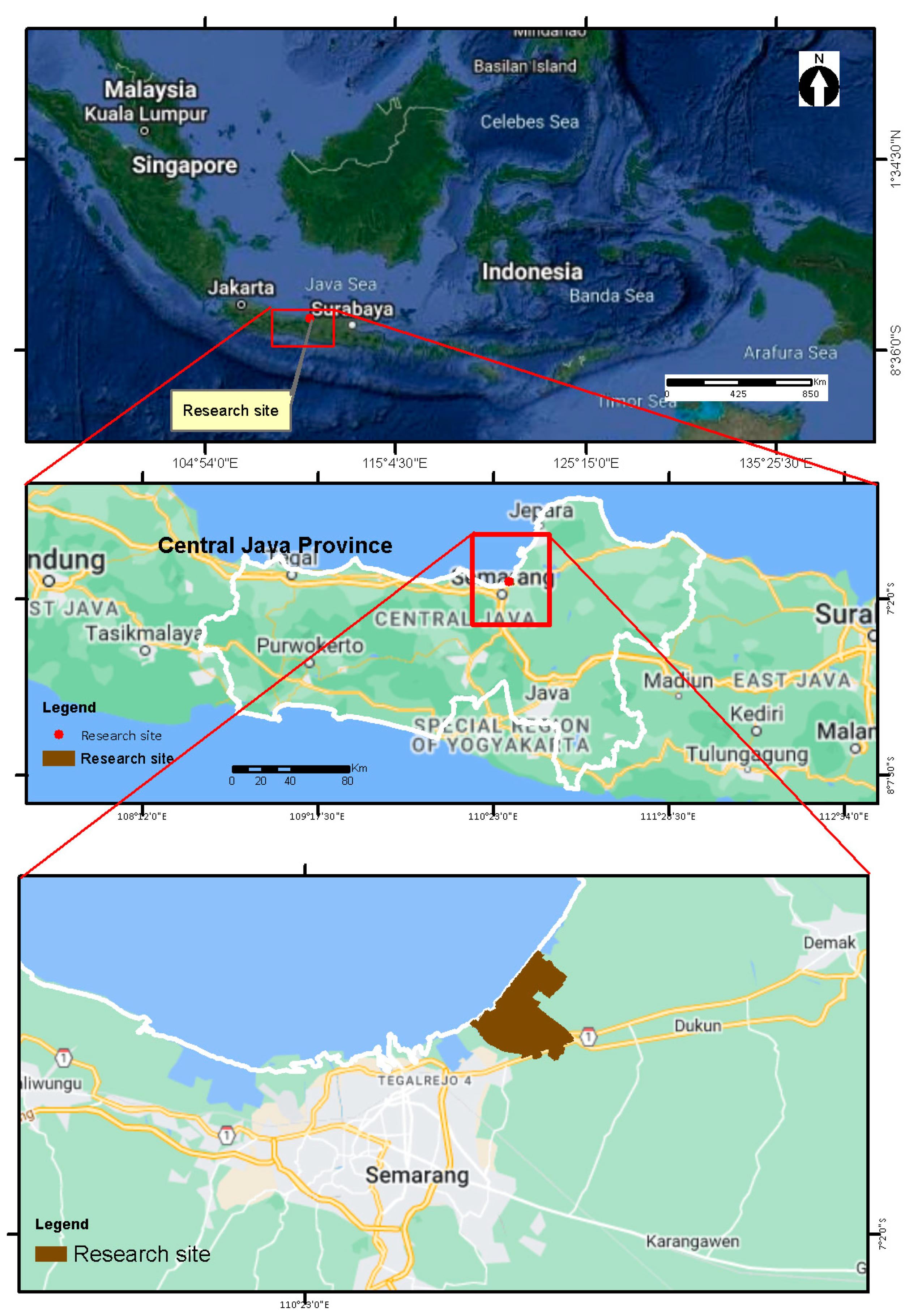
2. Materials and Methods

Kecamatan Sayung, a seaside district in Kabupaten Demak, Central Java was the chosen study area. For decades, this area has been subjected to tidal floods and severe abrasion, resulting in persistent inundation that has submerged substantial land parcels. As this area is designated as the project site for the building of the Toll Road and Sea Embarkment Project (also known as the TTLSD project), one of the Government’s Strategic National Projects (SNP), it serves as an ideal example for answering research questions. This project will be located in three villages in Kecamatan Sayung, namely Purwosari, Bedono, and Sriwulan, that will be the research site. Figure 1 demonstrates the location of the study area.
As a source of primary data, we conduct field observations and interviews with relevant stakeholders. The stakeholders included village government employees in the three villages identified as project sites, the head of the Kabupaten Demak Local Land Office, and members of the local community. We looked at secondary sources including articles, reports, and studies. We also analyzed secondary data such as articles, reports, and working papers. We used spatial data to visualize the change in landscape in the area, as well as to illustrate government’s strategy in succeeding the TTLSD project.
To reconstruct and identify land parcels in the research region, we used a taxation map obtained from the Local Land Office in Kabupaten Demak. To assess the shift in landscape, we obtained shoreline data from The Ministry of Marine and Fisheries retrieved from Geoportal Indonesia. The definition of shoreline used is from the Center of Geospatial Information of Indonesia, as the meeting line between land and sea that is influenced by tides. This shows land–sea boundaries derived from secondary data such as satellite imagery, aerial photographs, and hydrographic survey data. We used coastline data from 2013 and 2017 as the foundation for identification, keeping in mind that the TTLSD project used this as the basis for determining project affected area. We employed the Regional Spatial Planning Map of Kabupaten Demak, which was ratified in 2011 but then changed in 2020 to accommodate the project’s needs. To defend the government’s approach of supporting the SNP, we contrasted the original and updated versions.

3. Results and Discussion

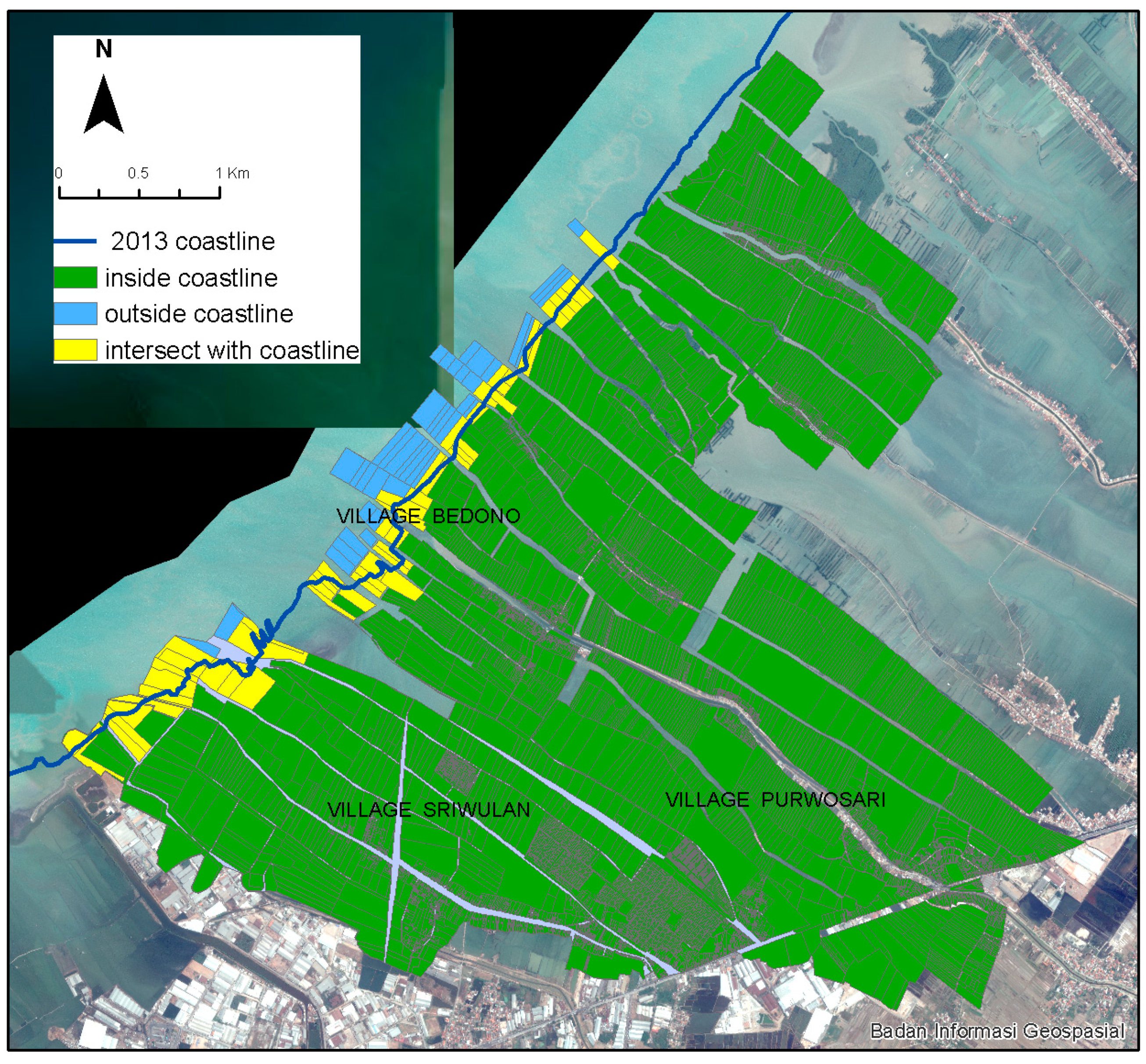
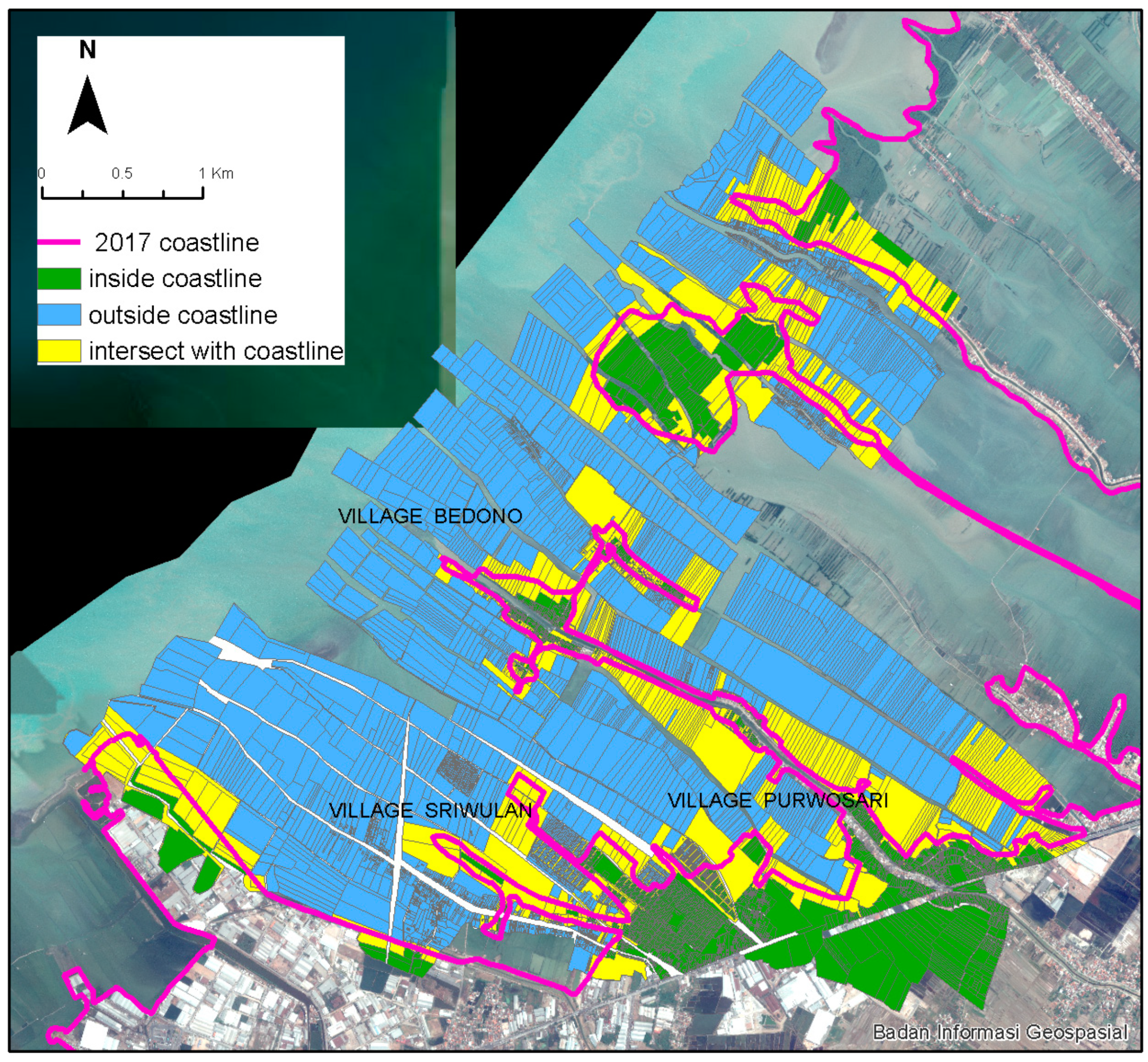
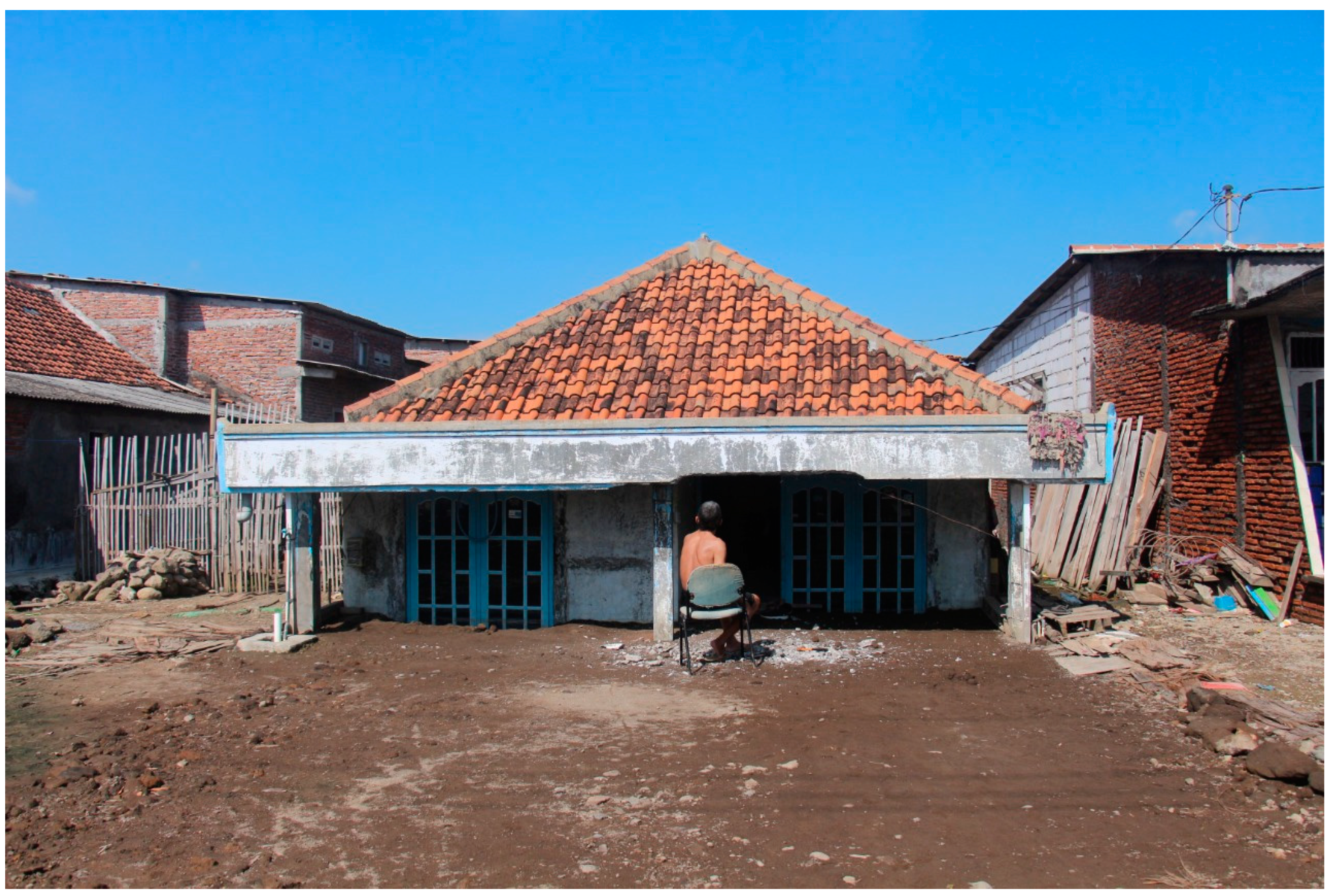
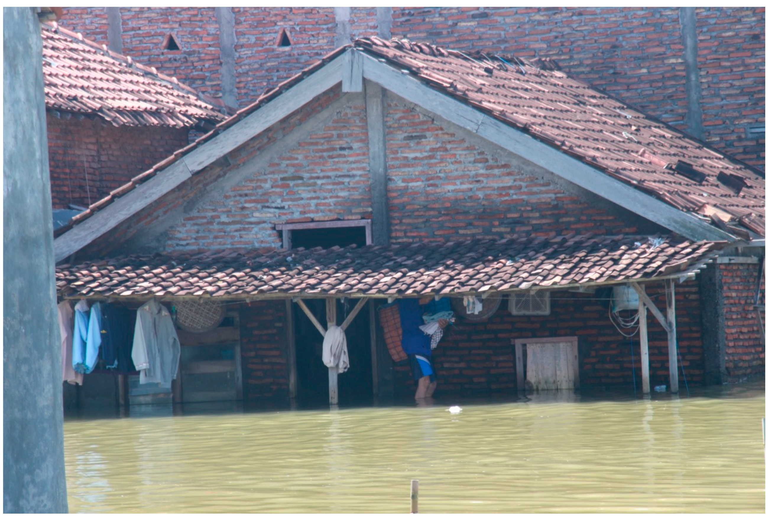
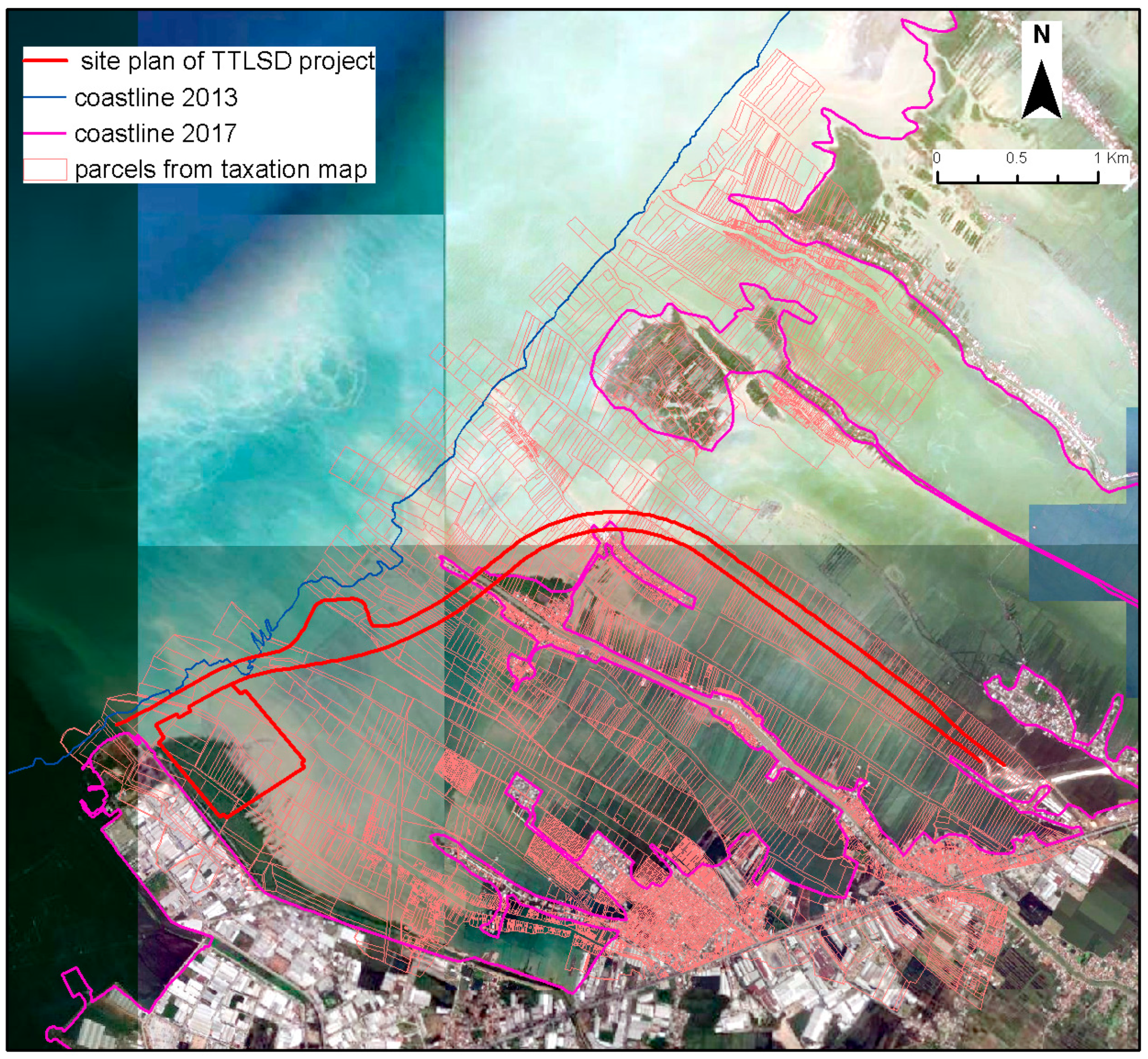
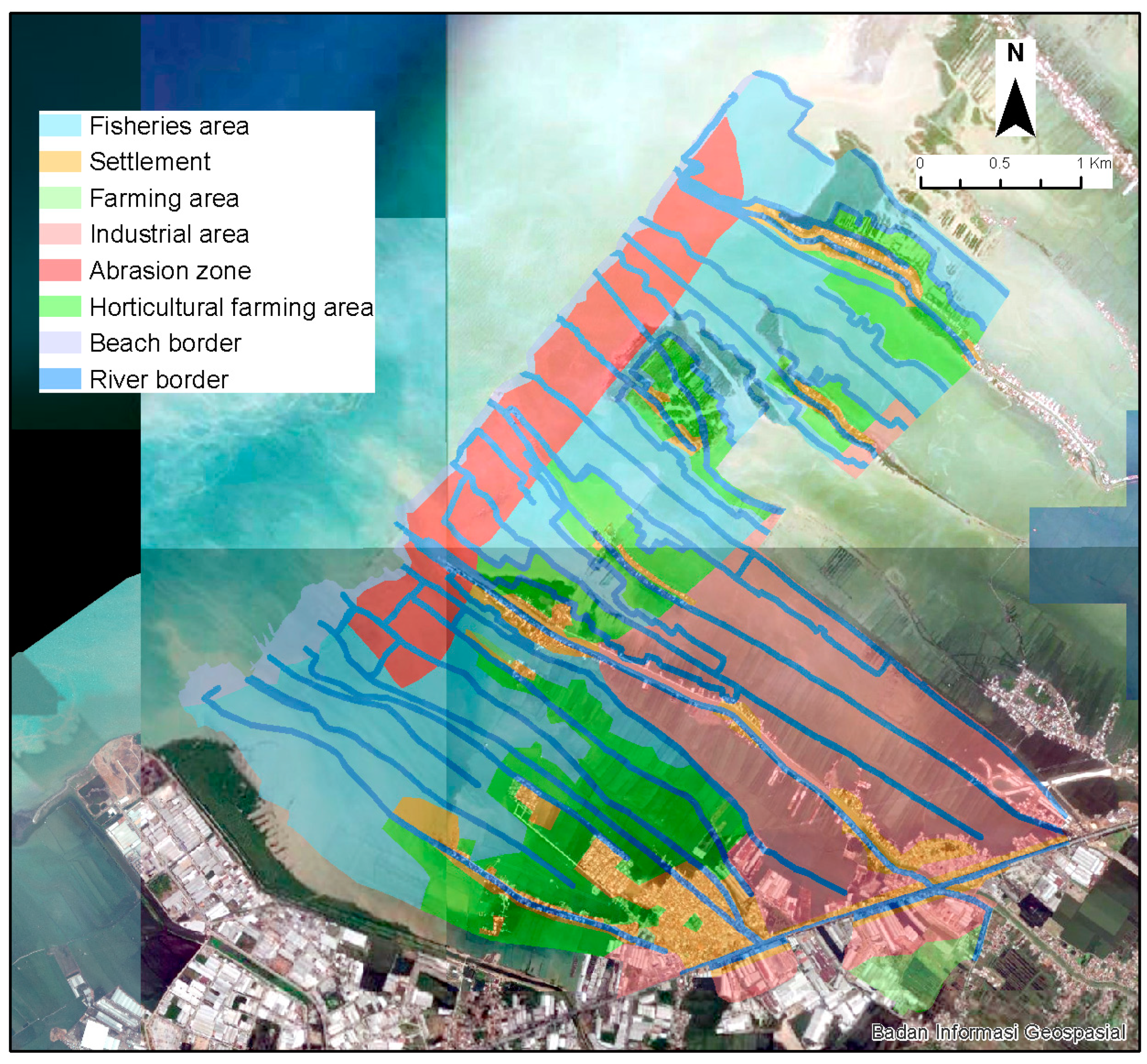
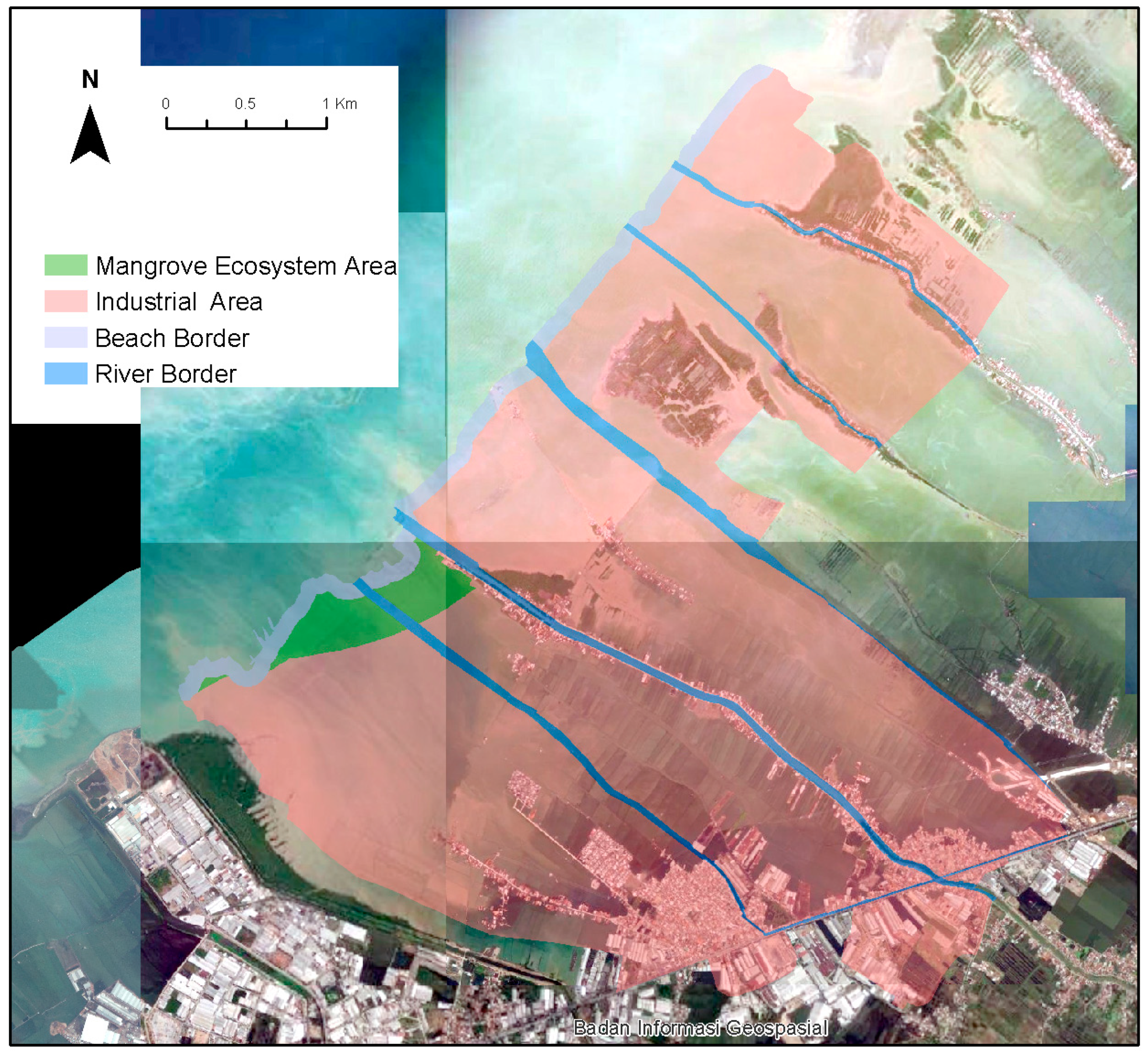
3.1. Landscape Change by the Time in the Study Area

Demak’s coastline area, located in the northern portion of Java Island, has grown into a city and residential area since the creation of the Islamic Kingdom of Demak in 1479. This location, which was also known as a center of trade and culture at the time, has grown significantly since the establishment of the Kingdom of Demak. Sayung is one of the districts of Demak’s coastline area, and it is directly adjacent to Kota Semarang in the west. This region is recognized as one of the industrial centers on Java island, and it spans along the island’s northern shore. Aside from its lengthy history as one of the most important centers of civilization on the island of Java, this area has long been afflicted by tidal flooding and extensive erosion, resulting in severe environmental and community problems [22]. Reports of this occurrence began around the year 1990, and by the year, it had an impact on the significant landscape transformation. According to data, the flood swamped an area of 2116.54 hectares between 1997 and 2015, while the coastline was displaced roughly 5.1 km land inward within 20 years due to abrasion [22,23,24]. Demak has also been claimed to have seen a 5 mm/year rise in sea level, which leads to an increase in the rate of abrasion in that location [25]. It is also said that around the same time period, two villages in District Sayung, Tambaksari and Rejosari, vanished due to abrasion. This area was well known as an agricultural area before to the tidal flood and severe abrasion. As a source of income, the peasants cultivated paddy fields and fishponds. Prior to the abrasion, the highest tides only reached the mangrove area, with just a few agricultural areas damaged by the tides [26].
The root causes of tidal flood and severe abrasion are complex; one of them is the hydrodynamic result of waves deflected from the eastern part of the area in Kota Semarang, one of the fastest growing industrial areas in Central Java, resulting in a concentration of higher wave energy in the western part in Kabupaten Demak [27,28]. This phenomenon appears to be caused by a mix of sea level rise and land subsidence [29,30,31,32,33]. The designation of the western part of Kabupaten Demak as an industrial region results in a high number of business activity as well as rapid infrastructure development along the coastal area. This leads to the reduction in ground water in the area, which worsens land subsidence, [29,30,31], not to mention other global factors such as the effect of climate change on sea level rise [34].
Tidal rob is ongoing these days, covering a progressively larger territory each year, with some areas in the region being permanently covered by sea water. According to recent data, tidal flooding has permanently submerged up to 16 settlements over the last 12 years [31,35]. Nonetheless, many residents opt to stay and refuse to relocate, despite the fact that they are subjected to flooding that occurs twice a day at varying depths. Most of those who stay maintain that they have no other place to live, cannot afford to move or buy a house elsewhere, and have no other source of income except from the sea [36]. Most residents who wish to stay should adjust to the situation by elevating the terrain on a regular basis to avoid sea water flooding and raising the houses, even though this does not guarantee that they will be safe from tidal floods in the long run [37,38]. In fact, people are still dealing with tidal floods that occur twice a day in varying depths depending on the season, which have an impact on their livelihood, such as decreased quality of life and uncertainties. Nonetheless, whether the position is too close to the sea or the landowner has the financial ability to perform landfilling, some of the flooding cannot be averted and the land has converted into sea. Some proprietors convert their previously owned land into a fish pond, while others relinquish their land.
While most of the land cannot be optionally functioned due to inundation, we confirmed that the majority of landowners continue to pay property taxes to the local government. Despite the fact that parcel has been turned into sea, the land is still registered in the taxation map. Some of the land is still legally registered and has an official land certificate. By paying property tax on an annual basis, the landowner claims that they still actively and technically own the land, despite the fact that their land has changed into the sea and cannot be used for its original purpose. This also demonstrates that the government legally recognizes the right to land.
By the time the coastline line has been dramatically shifted landward, portion of this land should be considered as open sea with no territory rights connected. Nonetheless, we discovered that approximately 15.800 parcels are registered in the taxation map. We overlaid the map with the 2013 coastline, and discovered that 48 land parcels are located beyond the coastline, 59 parcels intersect with the coastline, and 13.710 parcels are placed within the coastline. When we overlaid it with the 2017 shoreline, the number of land parcels beyond the coastline increased dramatically, reaching 6.318 parcels, with only 6.353 parcels remaining inside the coastline. During the period, we discovered 938,68 hectares of land that had turned into open sea. Table 1 displays the number of land parcels affected by shoreline changes between 2013 and 2017, whereas Figure 2 and Figure 3 depict the affected land parcels.
During our field observations, we discovered three types of waterlogged land in the research region. First, there was land that vanished totally and was replaced by sea. The remainder of this area is near the sea, with inundation as deep as 4 to 6 m. The majority of this land is no longer usable and was abandoned by the owner. Even so, some landowners continue to use wooden stakes to define the boundaries of their properties, as shown in Figure 4. This land cannot be used as a fishpond because it is too close to the open sea and the water currents are too powerful.
The second type of land has been inundated to a depth of 3 to 4 m, but due to its location closer to the mainland, it is unaffected by strong ocean currents. For this form of inundation, the owner can still use this “land” for fishponds and clam breeding, which has also become a major source of revenue for the majority of people living in the area. The landowner frequently installs fishnets to indicate their boundary on this area, as seen in Figure 5. Some landowners also collectively converted their land into fishponds and clam breeding cites, particularly those with small parcels.
The third type of land has partial inundation or has been inundated in shallow depth, allowing the landowner to proceed landfilling and inhabiting the land. This is usually land located along the major road (since the road has been regularly elevated) or near the mainland. In order to adjust with the rise of elevation, the landowner needs to raise their house. However, not many people are financially capable of doing so. Those who are unable to elevate the terrain must deal with low-roof housing, and some must live with waterlogging, as seen in Figure 6 and Figure 7.

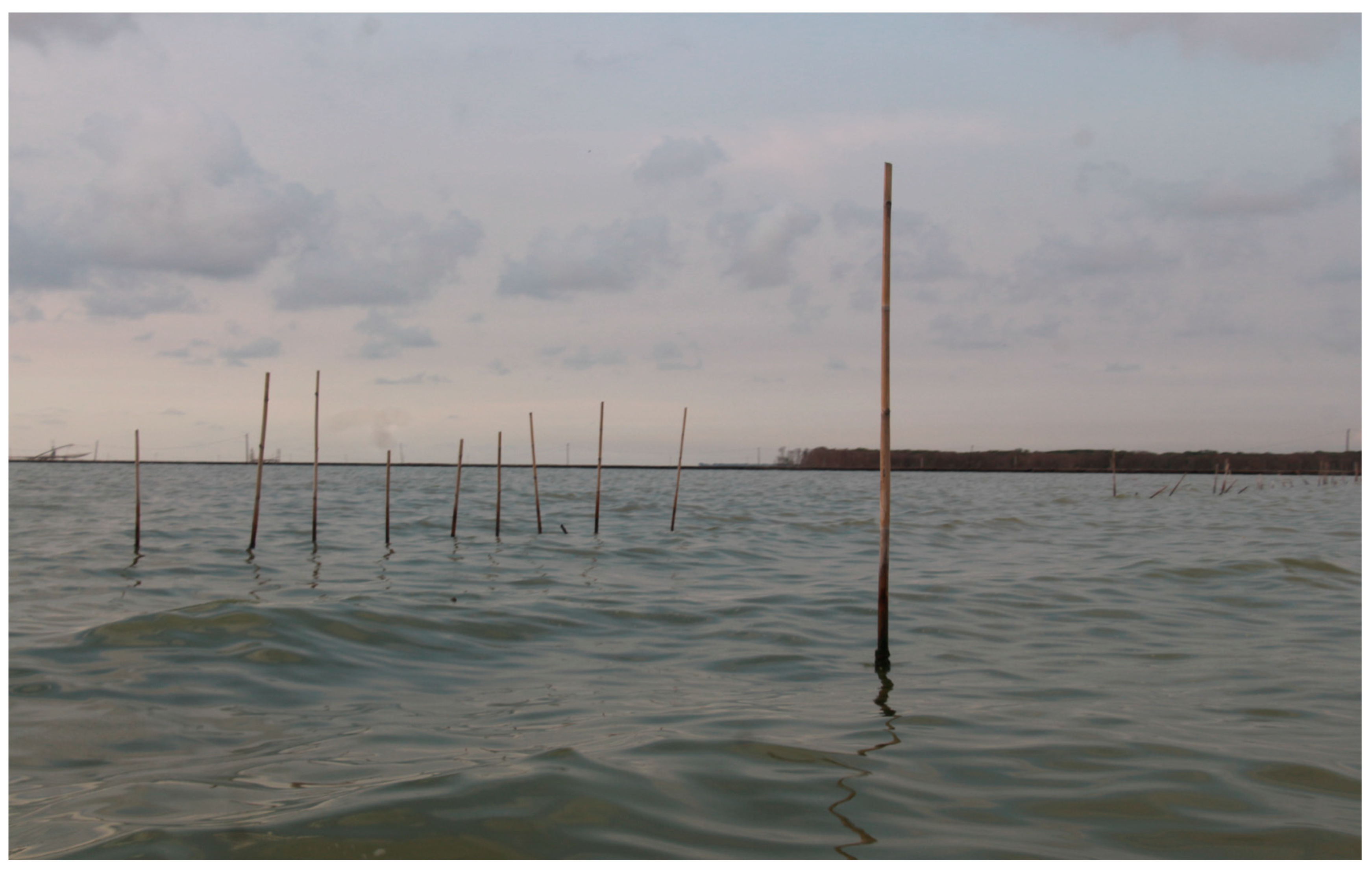
3.2. Permanently Inundated Land and Its Position in Land Law—Is It Obliterated or Inundated?

As the people of Kecamatan Sayung deal with tidal rob and the possibility of losing their land by the year, this inundation has spread to a larger region, and many land parcels have become sea. Attempts to mitigate the impact have been made, such as mangrove planting and the installation of hybrid engineering, a permeable structure made of bamboo and wooden branches that holds sediment to and from the sea and protects mangrove cultivation planted behind them, but it appears that these efforts were ineffective because sea currents are too strong [39,40]. On the other hand, the status of this flooded land is questionable. The government made no effort to relocate the affected inhabitants, and there is no official data on the number of land parcels inundated or the number of persons affected by the flooding. The government’s mitigation efforts appear to have had little effect in overcoming the calamity.
In Indonesia, inundated land is considered to be “obliterated land,” which, according to article (27) of the Basic Agrarian Law (Law Nr.5/1960), results in the loss of the legal tie between the landowner and their land. Formally, this means that the land is no longer considered to exist, or is obliterated, leading to an immediate loss and cancellation of any rights related to the land. Nonetheless, the status of obliterated land remained in the “grey area” for decades because there was no such derivative legislation guiding the assessment of obliterated land, nor any mechanism to refuse any claim related to it. This situation changed in 2021, when the government enacted Government Regulation Nr.18/2021, which established the basis for the cancellation of land rights, including obliterated land. At the same time, the government released Regulation of The Ministry of Agrarian Affairs and Spatial Planning Nr.17/2021, which specifies the process of establishing land as obliterated land in detail. This legislation also described obliterated land as land where its physical condition has changed due to a natural catastrophe, cannot be identified, and cannot properly function, be utilized, or used. Despite the fact that it appears to provide legal clarity over the property, these laws create debates.
If we further examine the situation, the underlying notion is to eliminate any right related to obliterated land because the land did not exist due to calamity events. Law Nr.24/2007 on Disaster Management further stated that the government is responsible for disaster management before, during, and after a disaster occurs. Nonetheless, there is no mention of “climate,” let alone “climate change,” in this legislation that is considered as disastrous event. This shows that the calamity alluded to in this act is a general disaster, not notably involving “climate-related disasters”. This could be because the tsunami disaster in Nangroe Aceh Darussalam in 2004 influenced the drafting of this Law, and the climate change factor was not considered.
The existing regulation, Government Regulation Nr.1/2021 and Regulation of The Ministry of Agrarian Affairs and Spatial Planning Nr.17/2021, defines permanently inundated land as obliterated land, and all rights related to it should be terminated. Landowners will not be compensated if their land is stipulated as obliterated land. We contend that the term “obliterated” is inappropriate in this context. First, the phrase “obliterated,” which results in the loss of land rights, is used in Statute Nr.5/1960 to refer to a disaster event, even though this law does not define whether the disaster is natural or human-triggered. This also implies that there should be a disaster event that results in the abolition of land rights, whereas in this study area, there was no stipulation or legal statement from the government to recognize the inundation as a disaster event, but rather as a natural phenomenon that occurred over time.
Second, we argue that the actual land still exists, despite being covered by sea water. This is not the case in the case of a landslide, for example, where the physical aspect of the land has completely vanished. In fact, several landowners continue to use the inundated land for economic activities such as fishpond and clam breeding area establishment, which have become a substantial source of revenue for the majority of the residents of the area. Landowners also attempt to place boundary markers on waterlogged land in an effort to preserve ownership of the land. Third, Regulation of The Ministry of Agrarian Affairs and Spatial Planning Nr.17/2021 defined obliterated land as land whose physical condition has changed due to a natural catastrophe. We also contend that climate change cannot be viewed solely as a natural process; there are human-related factors that increase the effects which must be thoroughly investigated before declaring an area as obliterated. As in the case of Kecamatan Sayung, tidal flooding and inundation were aggravated further by building and reclamation efforts near Semarang City, as well as the establishment of industrial zones along coastal areas, which caused soil subsidence and increased abrasion [15,26,28,34,41]. Furthermore, we argue that, as will be explained in the following sub-chapter, the failure of spatial planning also plays a substantial role in increasing the impact of climate change in this area.

3.3. Between Development Policy and the Blue Sea: Is This Land Still Recognized as Land?

As stated in the preceding sub-chapter, the Government ratified Government Regulation Nr.18/2021 in 2021, followed by Regulation of The Ministry of Agrarian Affairs and Spatial Planning Nr.17/2021 as a legal base for defining the status of obliterated land. However, its ratification was prompted by the government’s desire to construct a Strategic National Project in the area. The government plans to build a sea embarkment integrated with a toll road (further called as the TTLD project) to connect the “Mega-Commodities” of Central Java’s Northern Coastal Area: Kendal Industrial Area (KIA) in the west, industrial and commercial area in Kota Semarang as the center (including Tanjung Mas International Harbor and Ahmad Yani International Airport), and Central Java Industrial Park Sayung in the east. In fact, the purpose of this project is to connect the bounded industrial estate Kedung Sepur (Kendal–Demak–Ungaran–Salatiga–Semarang–Purwodadi). The construction of a toll road connecting this area is expected to improve connectivity and accessibility between the industrial area complex in the western part of Central Java, boost productivity by lowering distribution costs, provide access to regional and international markets, and reduce the consequences of tidal flooding and rapid abrasion in Kabupaten Demak. This project will involve the release of approximately 535 hectares of land, and the legal process of land acquisition has been in place since 2017. The designated project in Kabupaten Demak is located in three villages in Kecamatan Sayung: Bedono, Sriwulan, and Purwosari.
Unfortunately, the majority of the proposed project sites were once agricultural and settlement areas that are now permanently inundated by sea water, as seen in the map presented in Figure 8. The proposal, which was adopted in 2017, was delayed for five years because the government lacks a legal framework for implementing property acquisition for obliterated land. As the basic law on land acquisition for public works in Indonesia, Law Nr.2/2012 does not associate the arrangement of obliterated land in the land acquisition process; hence, this land cannot be released lawfully and the owner cannot obtain compensation. Nonetheless, there are still land rights attached to this permanently inundated land, and at that time, the government did not have a legal basis to specify the land as obliterated land. Therefore, the government then accelerated the stipulation of Government Regulation Nr.18/2021 in 2021 and Regulation of The Ministry of Agrarian Affairs and Spatial Planning Nr.17/2021 to solve the problem of land acquisition over inundated land.
By issuing government regulations concerning obliterated land, the swamped land shall subsequently be specified as obliterated land before revoking the land right. The first step is to specify the area that will be stipulated as obliterated. The local Land Office assembled a team to perform identification and assessment of the physical, social and environmental condition of land parcel, which will involve members from the municipal authorities, village government, and the community. Before the identification, the local Land Office should conduct socialization with relevant parties, including the community, as a notification that the area will be stipulated as obliterated. Following data collection and assessment, the local Land Office revealed the results of the assessment and notified the landowner before determining the land status. Landowners are provided the opportunity to conduct independent reclamation during this phase, which must be completed no later than one year after the notification. When there is no opposition from the owner or no reclamation proposed, the land is designated as obliterated land, and all rights related to it are revoked. The owner will not receive any compensation from the government under this approach.
The regulations were initially put in place to address the issue of land acquisition in the study area. Nonetheless, there remain challenges to execution, and the legislation has sparked opposition from numerous parties. The TTLSD project was first launched in 2017, but was delayed until 2022 due to complications with land right status. The government then reactivated the project by revising the permit through Governor Decree Nr.590/20, year 2022. The first permit used the 2013 shoreline as the reference to determine affected land parcel, with the consideration that if the shoreline used is at the time of the location was defined (2017), then most of the area will be located outside the coastline, which would be incompatible with spatial planning policies. In the second decree in 2022, the project used the 2017 shoreline as the baseline, with the same consideration as the first decree, because the inundation is becoming more widespread and affecting a growing number of land parcels.
There are 273 plots that have been recognized and will be designated as “obliterated”. The plots were located in three villages in Kecamatan Sayung: Bedono, Sriwulan and Purwosari. Table 2 presents the details of the land status of the plot and the associated physical condition.
At the time of writing of this paper, the process of the stipulation of obliterated land in the study area had not yet been implemented, mainly due to people’s resistance. The government declared that the project proponent will pay “mercy money” instead of compensation for up to 25% of the Sales Value of Taxable Object for the land that will be stipulated as obliterated land. Meanwhile, the Sales Value Taxable Object in the research region is deemed relatively low, at approximately INR 2500, per square meter (roughly USD 0.17), and a rough estimate resulted in the majority of land owners receiving less than INR 1,000,000 in compensation (approximately USD 670). Inadequate compensation is one of the elements generating community reluctance to relinquish their right of ownership, along with social enviousness from community members whose land was similarly permanently submerged but was not near the construction site and did not receive compensation. However, compensated land only covers a small portion of the total submerged area in these three villages.
As part of the project acceleration, the government revised spatial planning in Kabupaten Demak to align the project with the authorized spatial planning. The initial iteration of spatial planning (2011–2031) was based on Kabupaten Demak Regulation Nr.6/2011. This regulation was updated in 2020 to align with the TTLSD project. Figure 9 and Figure 10 provide a comparison of the first and second spatial planning maps.
In the first version of spatial planning, the frontline was designated as abrasion zone area as buffer zone to reduce the impact of inundation. However, in the revised version, practically all of the region has been designated as an industrial area in order to comply with the TTLSD project. The revised version increased the industrial area defined in the initial edition by over 80%, from approximately 327 hectares to 1471.6 hectares, and located along the coastal region of Kabupaten Demak. Given that the designated area has been subjected to severe abrasion and tidal flooding for years, we believe that the revised spatial planning did not meet the existing conditions.
Legally, the amendment to revise spatial planning is permitted under Presidential Regulation No. 3 of 2016 on the Implementation of National Strategic Projects. Article 19 (1) of this regulation states that SNP should be carried out in accordance with the designation of spatial planning in the area; however, article 19 (2) of the regulation also states that there is the possibility of revising the existing spatial planning if the SNP location is not in accordance with it, when the project technically cannot be relocated from the planned location. This, however, contradicts the Law Nr. 24/2007 on Disaster Management, which demands that the government be responsible for disaster risk reduction efforts and integrates them into development initiatives. Furthermore, the government did not consider the anthropogenic elements that are hastening the impact of climate change in this area, such as industrial operations in the area [29,31,42,43]. Following that, tidal floods and flooding have occurred for decades and are unpredictable, allowing them to be mitigated with adequate spatial planning. The designation of the area as an industrial area plainly contradicts the landscape’s characteristics, as this is an abrasion-prone location [44]. Instead, Spatial Planning-Based Ecosystem Adaptation (SPBEA) will be more suitable for implementation, especially in disaster-prone area [45].
Given the evidence, this indicates that the government prefers infrastructure development and success of the TTLSD project over social and environmental factors for more sustainable development, as well as recognition and protection of land ownership for affected people. First, the stipulation of the inundated land into obliterated with no compensation offered appears to disregard ownership history, as well as reasons behind the disaster—the causes, the aggravation factors, and stakeholders’ reaction to the disaster. In fact, this has been happening for decades, and it appears that the government was unaware of the problem.
Second, we propose that landowners should be compensated fairly and justly if their land is deemed obliterated. The first point is that the root and causes of the flooding are almost certainly related to anthropogenic factors such as development activities in the surrounding area, as stated in several researches [29,31,42,43]. Furthermore, there is still commercial activity such as fishpond and clam breeding area establishment, indicating that the land is still actively being used, even though its prior role has altered. Following that, because this area was forcibly designated for infrastructure development in the public interest, the victims should be compensated for the loss of their land and livelihood. If the compensation paid cannot be as large as what is required in a typical land acquisition case, it should be adequate for them to restore livelihood.
Third, we argue that the option to perform voluntary reclamation which was mentioned by the regulation is practically impossible to implement. Almost the majority of the land parcels that will be designated as destroyed land are located away from the mainland and have been significantly inundated. As a result, reclamation cannot be carried out in stages and will cost a lot of money, which is not the best option for landowners. Eventually, we argue that the designation of permanently inundated land should be performed for the entire area of inundation, rather than just the project-affected land, on the basis that the land is located in the same area.

4. Conclusions

It is always challenging to strike a balance between the need for development, environmental conservation, and protection of community rights over land, particularly in the context of climate change. Nonetheless, as the effects of climate change become more evident and unavoidable, the government should implement a more tenure-responsive policy, including development policy, to adjust to the situation.
We suggest that the stipulation of over-flooded land becoming obliterated land should be reviewed. The abolishment of rights to land that has been declared as obliterated should take into account various factors that caused the loss of the land, including whether it was purely due to natural disasters or whether there were anthropogenic factors that influenced it, such as the government’s negligence in regional planning and handling of the effects of climate change. The fact that the physical condition of the land has changed does not necessarily indicate that the right attached to it should be revoked, given that the majority of the land is still used for economic activities. The absence of compensation for obliterated land must be evaluated, keeping in mind that the site is defined as obliterated land for development purposes in the public interest. We propose that landowners whose land will be labelled as destroyed land and who have long been victims of the region’s climate disaster receive sufficient compensation that may be used to secure their livelihood. Given that there are still many other plots in the region with comparable situations, the government should approach this subject more seriously, as well as consider whether the regulations governing obliterated land adhere to the principles of justice and the protection of individuals’ rights in the face of tragedy.
In terms of land-use policy, we believe that disaster mitigation efforts should be prioritized, and that the designation of any infrastructure project, including SNP, should consider existing social and environmental conditions. The design of the SNP at the project site should also contribute to preventing and alleviating the impact of abrasion in the area. Furthermore, because the coastal area is a complex and mutually influencing ecosystem unit, spatial planning design in a given place such as the coastal area should be considered regionally rather than administratively. Next, given that this is a disaster-prone area, the categorization of the land as an industrial area should be reconsidered. We also emphasize the significance of data availability showing the extent of the area and the number of land parcels affected by permanent inundation, as well as economic and social profile of the affected people, so that it can be used in more comprehensive adaptation and mitigation efforts and sustainable planning.

Author Contributions

Conceptualization, S.P., T.W.R. and W.W.; methodology, S.P., T.W.R. and W.W.; software, S.P.; validation, S.P., T.W.R. and W.W.; formal analysis, S.P.; investigation, S.P., T.W.R. and W.W.; resources, S.P.; data curation, S.P.; writing—original draft preparation, S.P. and W.T.d.V.; writing—review and editing, S.P. and W.T.d.V.; visualization, S.P., T.W.R. and W.W.; supervision, W.T.d.V.; project administration, S.P. All authors have read and agreed to the published version of the manuscript.

Funding

This research received no external funding.

Institutional Review Board Statement

Not applicable.

Informed Consent Statement

Not applicable.

Data Availability Statement

Data are available upon request.

Acknowledgments

We thank the staff of STPN who contributed to the data collection.

Conflicts of Interest

The authors declare no conflict of interest.

References

  1. Hadley, D. Land use and the coastal zone. Land Use Policy 2009, 26, S198–S203. [Google Scholar] [CrossRef]
  2. Millar, I. There’s no place like home: Human displacement and climate change. Aust. Int. Law J. 2007, 14, 71–98. [Google Scholar]
  3. Atapattu, S. Climate change and displacement: Protecting ‘climate refugees’ within a framework of justice and human rights. J. Hum. Rights Environ. 2020, 11, 86–113. [Google Scholar] [CrossRef]
  4. Mertz, O.; Halsnæs, K.; Olesen, J.E.; Rasmussen, K. Adaptation to climate change in developing countries. Environ. Manag. 2009, 43, 743–752. [Google Scholar] [CrossRef] [PubMed] [Green Version]
  5. Mitchell, D.; McEvoy, D. Land Tenure and Climate Change Vulnerability; UN Habitat: Nairobi, Kenya, 2019. [Google Scholar]
  6. Arsana, I.; Andi, M. The Sinking of Sovereignty and Sovereign Rights: Mitigating the Impacts of Climate Change to Maritime Jurisdiction and a Proposal for Solutions. Indon. L. Rev. 2013, 3, 125. [Google Scholar] [CrossRef] [Green Version]
  7. Triana, K. Sea level rise in Indonesia: The drivers and the combined impacts from land subsidence. ASEAN J. Sci. Technol. Dev. 2020, 37, 115–121. [Google Scholar] [CrossRef]
  8. Nurhidayah, L. Sea-level rise (slr) and its implication on human security and human rights in indonesia: A legal analysis. Clim. Chang. Res. Policy Actions Indones. Sci. Adapt. Mitig. 2021, 524, 33–52. [Google Scholar]
  9. Handoko, E.Y.; Ariani, R. Analisis Kenaikan Muka Air Laut Indonesia Tahun 1993-2018 Menggunakan Data Altimetri. Geoid 2020, 15, 58–64. [Google Scholar] [CrossRef]
  10. Mitchell, D.; Enemark, S.; Van der Molen, P. Climate resilient urban development: Why responsible land governance is important. Land Use Policy 2015, 48, 190–198. [Google Scholar] [CrossRef]
  11. McCarthy, N. Tenure Security, Landscape Governance, and Climate Change: A Research Agenda; IFPRI: Washington, DC, USA, 2021. [Google Scholar]
  12. Minar, M.H.; Hossain, M.B.; Shamsuddin, M.D. Climate change and coastal zone of Bangladesh: Vulnerability, resilience and adaptability. Middle-East J. Sci. Res. 2013, 13, 114–120. [Google Scholar]
  13. Fleischhauer, M. The role of spatial planning in strengthening urban resilience. In Resilience of Cities to Terrorist and Other Threats; Springer: Berlin/Heidelberg, Germany, 2008; pp. 273–298. [Google Scholar]
  14. Davoudi, S.; Crawford, J.; Mehmood, A. Planning for Climate Change: Strategies for Mitigation and Adaptation for Spatial Planners; Earthscan: Oxford, UK, 2009. [Google Scholar]
  15. Nurhidayah, L.; Davies, P.; Alam, S.; Saintilan, N.; Triyanti, A. Responding to sea level rise: Challenges and opportunities to govern coastal adaptation strategies in Indonesia. Marit. Stud. 2022, 21, 1–14. [Google Scholar] [CrossRef]
  16. Nurhidayah, L.; McIlgorm, A. Coastal adaptation laws and the social justice of policies to address sea level rise: An Indonesian insight. Ocean Coast. Manag. 2019, 171, 11–18. [Google Scholar] [CrossRef]
  17. Quan, J.; Dyer, N. Climate Change and Land Tenure: The Implications of Climate Change for Land Tenure and Land Policy (Land Tenure Working Paper 2). 2008. Available online: ftp://ftp.fao.org/docrep/fao/011/aj332e/aj332e00.pdf (accessed on 9 December 2022).
  18. Arial, A.; Lau, T.H.; Runsten, L. Land tenure challenges in a changing climate. L. Tenure J. 2011, 2, 5–15. [Google Scholar]
  19. De Leon, E.G.; Pittock, J. Integrating climate change adaptation and climate-related disaster risk-reduction policy in developing countries: A case study in the Philippines. Clim. Dev. 2017, 9, 471–478. [Google Scholar] [CrossRef]
  20. Chowdhury, M.A.; Hasan, M.K.; Islam, S.L.U. Climate change adaptation in Bangladesh: Current practices, challenges and way forward. J. Clim. Chang. Health 2022, 6, 100108. [Google Scholar] [CrossRef]
  21. Djalante, R.; Thomalla, F. Disaster risk reduction and climate change adaptation in Indonesia: Institutional challenges and opportunities for integration. Int. J. Disaster Resil. Built Environ. 2012, 3, 166–180. [Google Scholar] [CrossRef]
  22. Hanifah, M.H.; Anna, A.N. Analisis Dampak Bencana Banjir Rob Terhadap Perubahan Struktur Sosial Dan Ekonomi Masyarakat Pesisir (Studi Kasus Kecamatan Sayung, Kabupaten Demak); Universitas Muhammadiyah Surakarta: Kartasura, Indonesia, 2022. [Google Scholar]
  23. Umami, K.; Harahap, S.A.; Syamsudin, M.L.; Sunarto, S. APLIKASI CITRA LANDSAT DALAM ANALISA PERUBAHAN GARIS PANTAI (Studi Kasus di Pesisir Sayung, Kabupaten Demak, Jawa Tengah). Semin. Nas. Geomatika 2019, 3, 919–928. [Google Scholar] [CrossRef]
  24. Ervita, K.; Marfai, M.A. Shoreline change analysis in Demak, Indonesia. J. Environ. Prot. 2017, 8, 940. [Google Scholar] [CrossRef] [Green Version]
  25. Marfai, M.A. Impact of sea level rise to coastal ecology: A case study on the northern part of Java Island, Indonesia. Quaest. Geogr. 2014, 33, 107–114. [Google Scholar] [CrossRef] [Green Version]
  26. Damayanti, R. Hilangnya Dua Kampung Pesisir Desa Bedono Kecamatan Sayung Kabupaten Demak Dalam Pusaran Abrasi dan Industrialisasi Tahun 1990–2010; Universitas Diponegoro: Kartasura, Indonesia, 2019. [Google Scholar]
  27. Muskananfola, M.R.; Febrianto, S. Spatio-temporal analysis of shoreline change along the coast of Sayung Demak, Indonesia using Digital Shoreline Analysis System. Reg. Stud. Mar. Sci. 2020, 34, 101060. [Google Scholar] [CrossRef]
  28. Lazuardi, T.A. Upaya Dalam Mengatasi Erosi Pantai Di Pesisir Utara Kecamatan Sayung, Kabupaten Demak, Jawa Tengah. Available online: https://www.academia.edu/38653297/UPAYA_DALAM_MENGATASI_EROSI_PANTAI_DI_PESISIR_UTARA_KECAMATAN_SAYUNG_KABUPATEN_DEMAK_JAWA_TENGAH (accessed on 9 December 2022).
  29. Damaywanti, K. Dampak Abrasi Pantai Terhadap Lingkungan Sosial (Studi Kasus di Desa Bedono, Sayung Demak). 2013. Available online: https://core.ac.uk/download/pdf/18605649.pdf (accessed on 9 December 2022).
  30. Rahmawan, L.E.; Yuwono, B.D.; Awaluddin, M. Survei Pemantauan Deformasi Muka Tanah Kawasan Pesisir Menggunakan Metode Pengukuran GPS Di Kabupaten Demak Tahun 2016 (Studi Kasus: Pesisir Kecamatan Sayung, Demak). J. Geod. Undip 2016, 5, 44–55. [Google Scholar]
  31. Gemilang, W.A.; Wisha, U.J.; Solihuddin, T.; Arman, A.; Ondara, K. Sediment accumulation rate in sayung coast, demak, central java using unsupported 210 Pb isotope. Atom Indones. 2020, 46, 25–32. [Google Scholar] [CrossRef]
  32. Marfai, M.A.; King, L. Monitoring land subsidence in Semarang, Indonesia. Environ. Geol. 2007, 53, 651–659. [Google Scholar] [CrossRef]
  33. Marfai, M.A.; King, L. Tidal inundation mapping under enhanced land subsidence in Semarang, Central Java Indonesia. Nat. Hazards 2008, 44, 93–109. [Google Scholar] [CrossRef]
  34. Andreas, H.; Pradipta, D.; Abidin, H.Z.; Sarsito, D.A. Early pictures of global climate change impact to the coastal area (North West of Demak Central Java Indonesia). AIP Conf. Proc. 2017, 1857, 90002. [Google Scholar]
  35. Astuti, S.; Muryani, C.; Rindarjono, M.G. The community participation on mangrove conservation in Sayung, Demak from 2004–2016. IOP Conf. Ser. Earth Environ. Sci. 2018, 145, 12087. [Google Scholar] [CrossRef]
  36. Buchori, I.; Pramitasari, A.; Pangi, P.; Sugiri, A.; Maryono, M.; Basuki, Y.; Sejati, A.W. Factors distinguishing the decision to migrate from the flooded and inundated community of Sayung, Demak: A suburban area of Semarang City, Indonesia. Int. J. Disaster Risk Reduct. 2021, 52, 101946. [Google Scholar] [CrossRef]
  37. Sarasadi, A.; Rudiarto, I.; Faradila, A. Adaptation Strategy of Tidal Flood Handling a Case Study in Sayung Sub-District, Demak. Forum Ilmu Sos. 2021, 48, 93–99. [Google Scholar]
  38. Sarasadi, A.; Rudiarto, I. Kerentanaan dan Strategi Adaptasi Masyarakat Terhadap Bencana Rob di Kawasan Pesisir Kecamatan Sayung Kabupaten Demak. Tek. PWK (Perencanaan Wil. Kota) 2021, 10, 91–102. [Google Scholar]
  39. Gemilang, W.A.; Wisha, U.J.; Ondara, K.; Dhiauddin, R. Hybrid engineering effectivity evaluation according to the changes in mangrove area and sedimentary rate in the eroded area of Sayung Regency, Demak, Central Java. IOP Conf. Ser. Earth Environ. Sci. 2018, 216, 12040. [Google Scholar] [CrossRef]
  40. Takagi, H. ‘Adapted mangrove on hybrid platform’–coupling of ecological and engineering principles against coastal hazards. Results Eng. 2019, 4, 100067. [Google Scholar] [CrossRef]
  41. Abidin, H.Z.; Andreas, H.; Gumilar, I.; Sidiq, T.P.; Fukuda, Y. Land subsidence in coastal city of Semarang (Indonesia): Characteristics, impacts and causes. Geomat. Nat. Hazards Risk 2013, 4, 226–240. [Google Scholar] [CrossRef] [Green Version]
  42. Batubara, B.; Warsilah, H.; Wagner, I.; Salam, S. Maleh dadi Segoro: Krisis Sosial-Ekologis Kawasan Pesisir Semarang-Demak. No. October, 2020. Available online: https://www.researchgate.net/publication/344804419_Maleh_dadi_Segoro_Krisis_Sosial-Ekologis_Kawasan_Pesisir_Semarang-Demak (accessed on 9 December 2022).
  43. Asiyah, S. Analisis Perubahan Permukiman Dan Karakteristik Permukiman Kumuh Akibat Abrasi Dan Inundasi Di Pesisir Kecamatan Sayung Kabupaten Demak Tahun 2003–2013 (Implementasi Pengayaan Materi Pembelajaran Geografi Di Sma Pada Kelas Xi Semester Ii Kurikulum Tingk; UNS (Sebelas Maret University): Kartasura, Indonesia, 2014. [Google Scholar]
  44. Kusuma, A.C.; Irwani, I.; Widada, S. Identifikasi Daerah Rawan Rob Untuk Evaluasi Tata Ruang Pemukiman Di Kabupaten Demak. J. Mar. Res. 2013, 2, 1–5. [Google Scholar]
  45. Sutrisno, D.; Darmawan, M.; Rahadiati, A.; Helmi, M.; Yusmur, A.; Hashim, M.; Shih, P.T.-Y.; Qin, R.; Zhang, L. Spatial-Planning-Based Ecosystem Adaptation (SPBEA): A Concept and Modeling of Prone Shoreline Retreat Areas. ISPRS Int. J. Geo-Inf. 2021, 10, 176. [Google Scholar] [CrossRef]
Figure 1. Location of the study area.
Land 12 00478 g001
Figure 2. Land parcel from taxation map overlaid with 2013 coastline. The 2013 coastline was accessed from the Ministry of Marine and Fisheries, while the taxation map was accessed from Local Land Office in Kabupaten Demak. The blue figure shows land parcel located outside the coastal area, while the yellow parcel depicts land parcel that intersect with the coastline, and the green parcels located inside the coastline.
Land 12 00478 g002
Figure 3. Land parcel from taxation map overlaid with 2017 coastline. The 2017 coastline was accessed from the Ministry of Marine and Fisheries, while the taxation map was accessed from Local Land Office in Kabupaten Demak. The blue figure shows land parcel located outside the coastal area, while the yellow parcel depicts land parcel that intersect with the coastline, and the green parcels located inside the coastline.
Land 12 00478 g003
Figure 4. First type of inundated land. The inundation depth can reach up to 6 m. Some of landowners use the bamboo stack to mark their land boundary. Its location is too close to the open sea, making it unsuitable for fish breeding. Source: field data collection.
Land 12 00478 g004
Figure 5. Second type of inundated land. Most of the land owners use this land for fishponds and clam breeding. The land owners use wooden stakes and fishnet to mark their land boundary. Source: field data collection.
Land 12 00478 g005
Figure 6. Houses with a very low roof. The landowner performs landfilling to avoid inundation, but is unable to heighten their house. Consequently, half of the house is stockpiled by the materials. Source: field data collection.
Land 12 00478 g006
Figure 7. Landowner who is unable to perform landfilling and unable to move to another area. Consequently, they have to adapt with the sea water that inundated the house. Source: field data collection.
Land 12 00478 g007
Figure 8. Site map of TTLSD project. The planned location is depicted in red line.
Land 12 00478 g008
Figure 9. First version of spatial planning in the study area in the period of 2011–2031 (before revision). In this version, the frontline of the area was designated as abrasion zone, and industrial area located landward.
Land 12 00478 g009
Figure 10. Second version of spatial planning in the study area in the period of 2011–2031 (after revision). In this version, almost all area is designated as industrial area, leaving only small portion for mangrove ecosystem area and beach border.
Land 12 00478 g010
Table 1. The number of land parcels and the area (in hectares) that located outside, intersect with, and inside the coastline in 2013 and 2017. Land parcel data sourced from the taxation map issued by Local Government of Kabupaten Demak, while the coastline data were obtained from the Ministry of Marine and Fisheries.
2013 Coastline2017 Coastline
Number of ParcelsHectaresNumber of ParcelsHectares
Outside coastline4846.436318985.12
Intersect with coastline5982.451142430.48
Inside coastline13,7101507.146353220.43
Total15,8301636.0215,8301636.02
Table 2. Land status and boundary identification per location.
LocationTotal PlotLand StatusBoundary Identification and Physical Condition
FreeholdLetter C
Bedono113 plots7106A total of 99 plots cannot be identified, 13 plots partially recognized, 1 plot can be recognized
Sriwulan47 plots2225All plots are used as fishpond with no clear boundary
Purwosari113 plots3979A total of 97 plots cannot be identified, 16 plots can be recognized
Total273682101636.2
Disclaimer/Publisher’s Note: The statements, opinions and data contained in all publications are solely those of the individual author(s) and contributor(s) and not of MDPI and/or the editor(s). MDPI and/or the editor(s) disclaim responsibility for any injury to people or property resulting from any ideas, methods, instructions or products referred to in the content.

