

Reimagining the Development of Downtown Cahokia Using Remote Sensing Visualizations from the Western Edge of the Grand Plaza
 , , ,
, , ,
Abstract
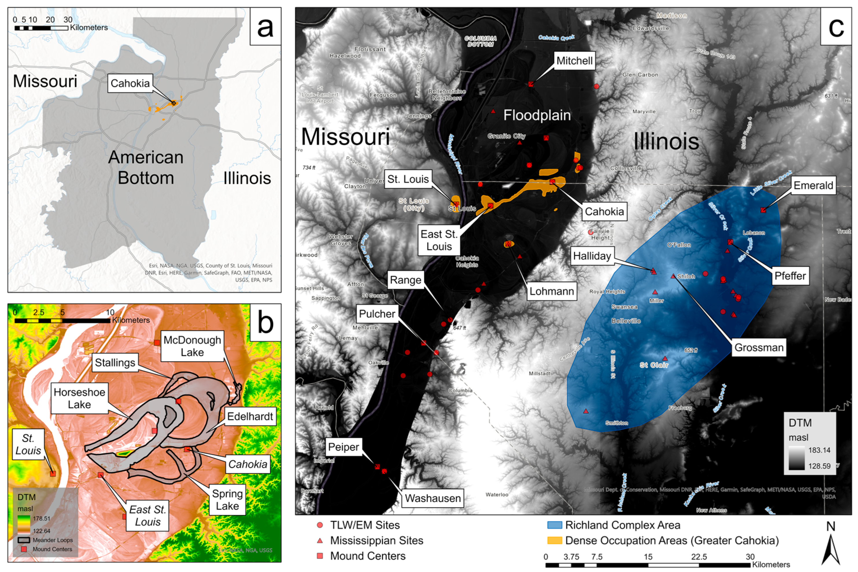
:1. Introduction
2. Background: Cahokia’s Emergence and Developments in Its Downtown
Documenting Known Architecture in the Survey Area
3. Methods and Analyses
3.1. Historic Aerial Photographs
3.2. LiDAR-Derived Surface Visualizations
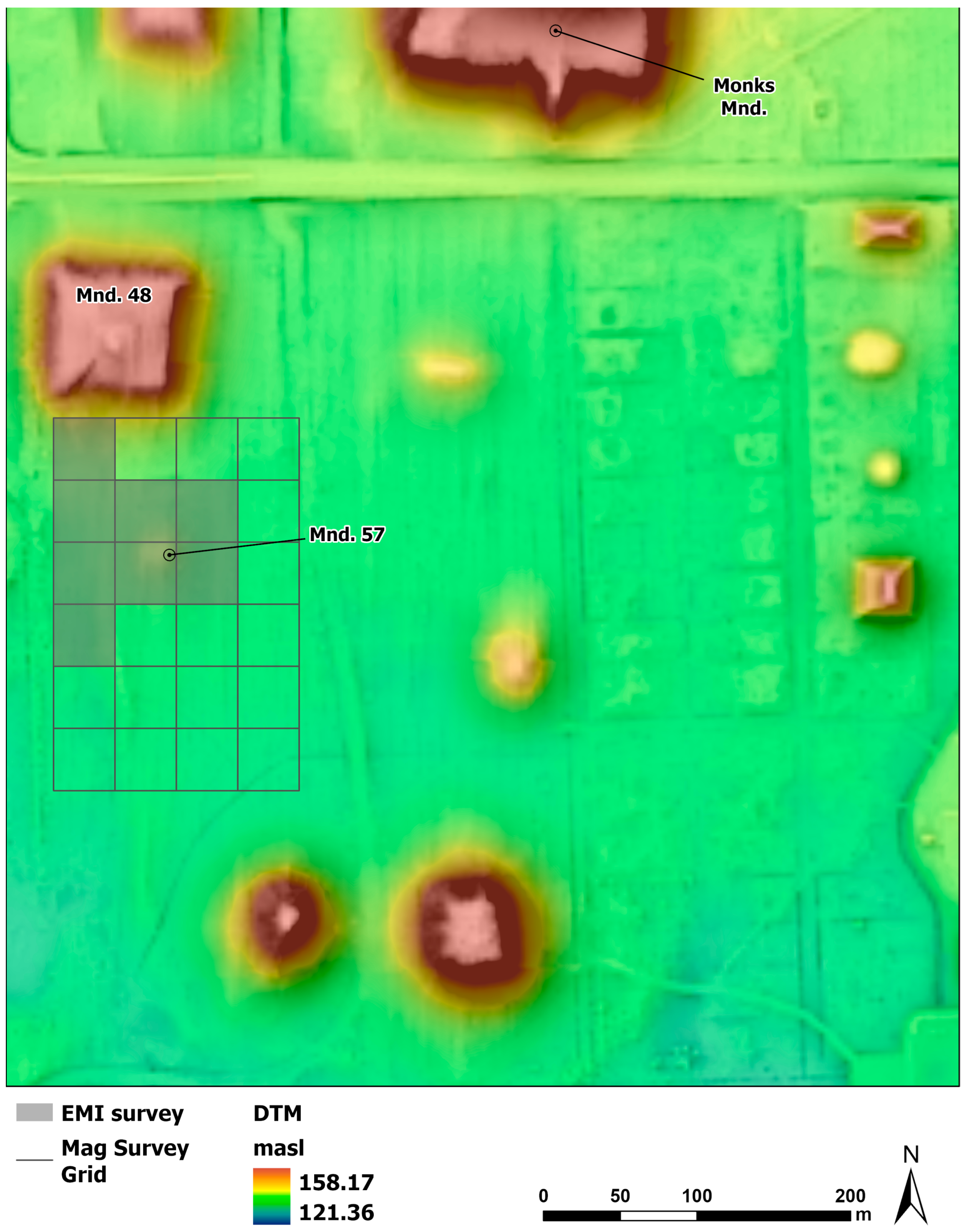
3.3. Archaeogeophysical Surveys
4. Results
4.1. Aerial Imagery and Insights from the Western Edge of the Grand Plaza
4.2. LiDAR-Derived Surface Visualizations from the Grand Plaza
4.3. Magnetic Gradiometry Survey
4.4. Electromagnetic Induction Survey
5. Discussion
6. Conclusions
Supplementary Materials
Author Contributions
Funding
Institutional Review Board Statement
Informed Consent Statement
Data Availability Statement
Acknowledgments
Conflicts of Interest
References
- Bourdieu, P. Social Space and the Genesis of Appropriated Physical Space. Int. J. Urban Reg. Res. 2018, 42, 106–114. [Google Scholar] [CrossRef] [Green Version]
- Lefebvre, H. The Production of Space; Wiley: London, UK, 1992; ISBN 978-0-631-18177-4. [Google Scholar]
- Low, S.M. Indigenous Architecture and the Spanish American Plaza in Mesoamerica and the Caribbean. Am. Anthropol. 1995, 97, 748–762. [Google Scholar] [CrossRef]
- Low, S.M. Claiming Space for an Engaged Anthropology: Spatial Inequality and Social Exclusion. Am. Anthropol. 2011, 113, 389–407. [Google Scholar] [CrossRef]
- Cordova, V.F. How It Is: The Native American Philosophy of V. F. Cordova; University of Arizona Press: Tucson, AZ, USA, 2007; ISBN 978-0-8165-2649-9. [Google Scholar]
- Norton-Smith, T.M. The Dance of Person and Place: One Interpretation of American Indian Philosophy; SUNY Press: Albany, NY, USA, 2010; ISBN 978-1-4384-3134-5. [Google Scholar]
- Todd, Z. An Indigenous Feminist’s Take on The Ontological Turn: ‘Ontology’ Is Just Another Word for Colonialism. J. Hist. Sociol. 2016, 29, 4–22. [Google Scholar] [CrossRef]
- Watts, V. Indigenous Place-Thought and Agency Amongst Humans and Non-Humans (First Woman and Sky Woman Go on a European World Tour!). Decolonization Indig. Educ. Soc. 2013, 2, 20–34. [Google Scholar]
- Zedeño, M.N.; Pickering, E.; Lanoë, F. Oral Tradition as Emplacement: Ancestral Blackfoot Memories of the Rocky Mountain Front. J. Soc. Archaeol. 2021, 21, 306–328. [Google Scholar] [CrossRef]
- Morrison, K.M. The Cosmos as Intersubjective: Native American Other-than-Human Persons. In Indigenous Religions: A Companion; Harvey, G., Ed.; Bloomsbury Publishing: London, UK, 2000; pp. 23–36. [Google Scholar]
- Zedeño, M.N. Animating by Association: Index Objects and Relational Taxonomies. Camb. Archaeol. J. 2009, 19, 407–417. [Google Scholar] [CrossRef]
- Barrier, C.R.; Kassabaum, M.C. Gathering in the Late Woodland: Plazas and Gathering Places as Everyday Space. In Investigating the Ordinary: Everyday Matters in Southeast Archaeology; Price, S.E., Carr, P.J., Eds.; University Press of Florida: Gainesville, FL, USA, 2018; pp. 164–184. [Google Scholar]
- Thompson, V.D. The Mississippian Production of Space through Earthen Pyramids and Public Buildings on the Georgia Coast, USA. World Archaeol. 2009, 41, 445–470. [Google Scholar] [CrossRef]
- Cobb, C.R.; Butler, B.M. Mississippian Plazas, Performances, and Portable Histories. J. Archaeol. Method Theory 2017, 24, 676–702. [Google Scholar] [CrossRef]
- Iseminger, W.R. Cahokia Mounds: America’s First City; History Press: Cheltenham, UK, 2010; ISBN 978-1-59629-734-0. [Google Scholar]
- Kelly, J.E.; Brown, J.A. Cahokia: The Processes and Principles of the Creation of an Early Mississippian City. In Making Ancient Cities: Space and Place in Early Urban Societies; Creekmore, A.T., III, Fisher, K.D., Eds.; Cambridge University Press: Cambridge, UK, 2014; pp. 292–336. [Google Scholar]
- Pauketat, T.R. Cahokia: Ancient America’s Great City on the Mississippi; Penguin: New York, NY, USA, 2009; ISBN 978-1-101-10517-7. [Google Scholar]
- Alt, S.M.; Kruchten, J.D.; Pauketat, T.R. The Construction and Use of Cahokia’s Grand Plaza. J. Field Archaeol. 2010, 35, 131–146. [Google Scholar] [CrossRef]
- Dalan, R.A.; Holley, G.R.; Woods, W.; Watters, H.W., Jr.; Koepke, J. Envisioning Cahokia: A Landscape Perspective; Northern Illinois University Press: Dekalb, IL, USA, 2003; ISBN 978-0-87580-302-9. [Google Scholar]
- The Archaeology of Villages in Eastern North America; Birch, J.; Thompson, V.D. (Eds.) University Press of Florida: Gainesville, FL, USA, 2018. [Google Scholar]
- Munoz, S.E.; Schroeder, S.; Fike, D.A.; Williams, J.W. A Record of Sustained Prehistoric and Historic Land Use from the Cahokia Region, Illinois, USA. Geology 2014, 42, 499–502. [Google Scholar] [CrossRef]
- Munoz, S.E.; Gruley, K.E.; Massie, A.; Fike, D.A.; Schroeder, S.; Williams, J.W. Cahokia’s Emergence and Decline Coincided with Shifts of Flood Frequency on the Mississippi River. Proc. Natl. Acad. Sci. USA 2015, 112, 6319–6324. [Google Scholar] [CrossRef] [PubMed] [Green Version]
- Baires, S.E. Land of Water, City of the Dead: Religion and Cahokia’s Emergence; University of Alabama Press: Tuscaloosa, AL, USA, 2017; ISBN 978-0-8173-1952-6. [Google Scholar]
- Rankin, C.G. The Exceptional Environmental Setting of the North Plaza, Cahokia Mounds, Illinois, USA. World Archaeol. 2022, 84, 84–106. [Google Scholar] [CrossRef]
- Kelly, J.E. Range Site Community Patterns and the Mississippian Emergence. In The Mississippian Emergence; Smith, B.D., Ed.; University of Alabama Press: Tuscaloosa, AL, USA, 2007; pp. 67–112. [Google Scholar]
- Kelly, J.E.; Ozuk, S.J.; Jackson, D.K.; McElrath, D.L.; Finney, F.A.; Esarey, D. Late Woodland Period. In American Bottom Archaeology; Bareis, C.J., Porter, J.W., Eds.; University of Illinois Press: Urbana, IL, USA, 1984; pp. 104–127. [Google Scholar]
- Kelly, J.E.; Fortier, A.C.; Ozuk, S.J.; Williams, J.A. The Range Site: Archaic through Late Woodland Occupations; University of Illinois Press: Urbana, IL, USA, 1987; p. 486. [Google Scholar]
- Barrier, C.R. Town Aggregation and Abandonment during the Era of Urban Transformations in the Cahokia Region: Bayesian Modeling of the Washausen Mound-Town. J. Archaeol. Sci. Rep. 2017, 11, 523–535. [Google Scholar] [CrossRef] [Green Version]
- Barrier, C.R.; Horsley, T.J. Shifting Communities: Demographic Profiles of Early Village Population Growth and Decline in the Central American Bottom. Am. Antiq. 2014, 79, 295–313. [Google Scholar]
- Betzenhauser, A.; Pauketat, T.R. Elements of Cahokian Neighborhoods. Archeol. Pap. Am. Anthropol. Assoc. 2019, 30, 133–147. [Google Scholar] [CrossRef] [Green Version]
- Fowler, M.L. Cahokia: Ancient Capital of the Midwest; Addison-Wesley Publishing Company: Boston, MA, USA, 1974; ISBN 978-0-201-11535-2. [Google Scholar]
- Fowler, M.L. A Pre-Columbian Urban Center on the Mississippi. Sci. Am. 1975, 233, 92–101. [Google Scholar] [CrossRef]
- Iseminger, W.R. Cahokia: A Mississippi Metropolis. Cent. States Archaeol. J. 1986, 33, 228–244. [Google Scholar]
- Brackenridge, H.M. Topography of Saint Louis. Louisiana Gazette, 11 October 1810; 120–122. [Google Scholar]
- Brackenridge, H.M. Views of Louisiana; Together with a Journal of a Voyage Up the Missouri River, in 1811; American Classics; Quadrangle Books: Chicago, IL, USA, 1962. [Google Scholar]
- Gregg, M.L. A Population Estimate for Cahokia. In Perspectives in Cahokia Archaeology; Brown, J.A., Ed.; Illinois Archaeological Survey, Bulletin; University of Illinois Press: Urbana, IL, USA, 1975; pp. 126–136. [Google Scholar]
- Kelly, J.E. Redefining Cahokia: Principles and Elements of Community Organization. Wis. Archaeol. 1996, 77, 97–119. [Google Scholar]
- Milner, G.R. The Cahokia Chiefdom: The Archaeology of a Mississippian Society; University Press of Florida: Gainesville, FL, USA, 2006; ISBN 978-0-8130-2981-8. [Google Scholar]
- Pauketat, T.R.; Lopinot, N.H. Cahokian Population Dynamics. In Domination and Ideology in the Mississippian World; Pauketat, T.R., Emerson, T.E., Eds.; University of Nebraska Press: Lincoln, OR, USA, 1997; pp. 103–123. [Google Scholar]
- Trubitt, M.B.D. Mound Building and Prestige Goods Exchange: Changing Strategies in the Cahokia Chiefdom. Am. Antiq. 2000, 65, 669–690. [Google Scholar] [CrossRef]
- Kelly, J.E. Contemplating Cahokia’s Collapse. In Global Perspectives on the Collapse of Complex Systems; Railey, J.A., Reycraft, R.M., Eds.; Anthropological Papers; Maxwell Museum of Anthropology: Albuquerque, NM, USA, 2008; pp. 147–168. [Google Scholar]
- Krus, A.M. The Timing of Precolumbian Militarization in the U.S. Midwest and Southeast. Am. Antiq. 2016, 81, 375–388. [Google Scholar] [CrossRef] [Green Version]
- Iseminger, W.R.; Pauketat, T.R.; Koldehoff, B.; Kelly, L.S.; Blake, L. Archaeology of the Cahokia Palisade: The East Palisade Excavations; Illinois Cultural Resource Study; Illinois Historic Preservation Agency: Springfield, IL, USA, 1990. [Google Scholar]
- Revealing Greater Cahokia, North America’s First Native City: Rediscovery and Large-Scale Excavations of the East St. Louis Precinct; Emerson, T.E.; Koldehoff, B.H.; Brennan, T.K. (Eds.) Studies in Archaeology; Illinois State Archaeological Survey: Urbana/Champaign, IL, USA, 2018. [Google Scholar]
- Pauketat, T.R. The Archaeology of Downtown Cahokia: The Tract 15A and Dunham Tract Excavations; Studies in Illinois Archaeology; Illinois Transportation and Archaeological Research Program: Urbana, IL, USA, 1998. [Google Scholar]
- Alt, S.M. Identities, Traditions and Diversity in Cahokia’s Uplands. Midcont. J. Archaeol. 2002, 27, 217–236. [Google Scholar]
- Alt, S.M. Making Mississippian at Cahokia. In The Oxford Handbook of North American Archaeology; Pauketat, T.R., Ed.; Oxford University Press: Oxford, UK, 2012; pp. 497–508. [Google Scholar]
- Baires, S.E.; Butler, A.J.; Skousen, B.J.; Pauketat, T.R. Fields of Movement in the Ancient Woodlands of North America. In Archaeology after Interpretation: Returning Materials to Archaeological Theory; Alberti, B., Jones, A.M., Pollard, J., Eds.; Left Coast Press: Walnut Creek, CA, USA, 2013; pp. 197–218. [Google Scholar]
- Pauketat, T.R. Resettled Farmers and the Making of a Mississippian Polity. Am. Antiq. 2003, 68, 39–66. [Google Scholar] [CrossRef]
- Pauketat, T.R.; Alt, S.M.; Kruchten, J.D. The Emerald Acropolis: Elevating the Moon and Water in the Rise of Cahokia. Antiquity 2017, 91, 207–222. [Google Scholar] [CrossRef] [Green Version]
- Skousen, B.J. Rethinking Archaeologies of Pilgrimage. J. Soc. Archaeol. 2018, 18, 261–283. [Google Scholar] [CrossRef]
- Skousen, B.J.; Larson, T.H.; Malouchos, E.W.; Kruchten, J.D.; Barzilai, R.M.; Alt, S.M.; Pauketat, T.R. Archaeological Investigations on the Emerald Avenue, a Potential Mississippian Period Roadway in Southwestern Illinois. J. Field Archaeol. 2020, 45, 372–393. [Google Scholar] [CrossRef]
- Kassabaum, M.C. A History of Platform Mound Ceremonialism: Finding Meaning in Elevated Ground; University of Florida Press: Gainesville, FL, USA, 2021; ISBN 978-1-68340-207-7. [Google Scholar]
- Sherwood, S.C.; Kidder, T.R. The DaVinci’s of Dirt: Geoarchaeological Perspectives on Native American Mound Building in the Mississippi River Basin. J. Anthropol. Archaeol. 2011, 30, 69–87. [Google Scholar] [CrossRef]
- Kidder, T.R.; Sherwood, S.C. Look to the Earth: The Search for Ritual in the Context of Mound Construction. Archaeol. Anthropol. Sci. 2017, 9, 1077–1099. [Google Scholar] [CrossRef]
- Holley, G.R.; Dalan, R.A.; Smith, P.A. Investigations in the Cahokia Site Grand Plaza. Am. Antiq. 1993, 58, 306–319. [Google Scholar] [CrossRef]
- Kidder, T.R. Plazas as Architecture: An Example from the Raffman Site, Northeast Louisiana. Am. Antiq. 2004, 69, 514–532. [Google Scholar] [CrossRef]
- Lacquement, C.H. Physical Modifications to Late Prehistoric Plazas in the Southeast U.S. J. Anthropol. Archaeol. 2020, 58, 101164. [Google Scholar] [CrossRef]
- Vilbig, J.M.; Sagan, V.; Bodine, C. Archaeological Surveying with Airborne LiDAR and UAV Photogrammetry: A Comparative Analysis at Cahokia Mounds. J. Archaeol. Sci. Rep. 2020, 33, 102509. [Google Scholar] [CrossRef]
- Kelly, J.E.; Brown, J.A.; Hamlin, J.M.; Kelly, L.S.; Kozuch, L.; Parker, K.C.; Van Nest, J. The Context for the Early Evidence of the Southeastern Ceremonial Complex at Cahokia. In Southeastern Ceremonial Complex: Chronology, Content, Context; King, A., Ed.; University Alabama Press: Tuscaloosa, AL, USA, 2007; pp. 57–87. [Google Scholar]
- Pauketat, T.R. Temples for Cahokia Lords: Preston Holder’s 1955–1956 Excavations of Kunnemann Mound; University of Michigan Press: Ann Arbor, MI, USA, 1993; ISBN 978-1-951538-00-2. [Google Scholar]
- Ashmore, W. Biographies of Place at Quiriguá, Guatemala. In The Archaeology of Meaningful Places; Bowser, B.J., Zedeño, M.N., Eds.; University of Utah Press: Salt Lake City, UT, USA, 2009; pp. 15–31. [Google Scholar]
- Henry, E.R.; Mueller, N.G.; Jones, M.B. Ritual Dispositions, Enclosures, and the Passing of Time: A Biographical Perspective on the Winchester Farm Earthwork in Central Kentucky, USA. J. Anthropol. Archaeol. 2021, 62, 101294. [Google Scholar] [CrossRef]
- Wright, A.P. Garden Creek: The Archaeology of Interaction in Middle Woodland Appalachia; University of Alabama Press: Tuscaloosa, AL, USA, 2019; ISBN 978-0-8173-2040-9. [Google Scholar]
- Skousen, B.J.; Friberg, C.M. Investigating Mississippian Landscapes, Places, and Identities through Geophysics. J. Archaeol. Sci. Rep. 2021, 36, 102879. [Google Scholar] [CrossRef]
- Spivey-Faulkner, S.M. Juggling Sand: Ethics, Identity, and Archaeological Geophysics in the Mississippian World. J. Archaeol. Sci. Rep. 2021, 36, 102882. [Google Scholar] [CrossRef]
- The Archaeology of Downtown Cahokia II: The 1960 Excavation of Tract 15B; Pauketat, T.R. (Ed.) Illinois State Archaeological Survey: Urbana, IL, USA, 2013; ISBN 978-1-930487-25-3. [Google Scholar]
- Bareis, C.J. Meander Loops and the Cahokia Site. Am. Antiq. 1964, 30, 89–91. [Google Scholar] [CrossRef]
- Dalan, R.A. Defining Archaeological Features with Electromagnetic Surveys at the Cahokia Mounds State Historic Site. Geophysics 1991, 56, 1280–1287. [Google Scholar] [CrossRef]
- Stauffer, J.G. Cahokia’s Hidden Landscape: Mound Building and Landscape Modification in the Ramey Field. Ph.D. Thesis, Washington University in St. Louis, St. Louis, MO, USA, 2022. [Google Scholar]
- Stauffer, J.G.; Kelly, J.E. Dating the Bareis Mound. Ill. Antiq. 2021, 56, 1–6. [Google Scholar]
- Bold, R. Constructing Cosmoscapes: Cosmological Currents in Conversation and Contestation in Contemporary Bolivia. HAU J. Ethnogr. Theory 2020, 10, 195–208. [Google Scholar] [CrossRef]
- Hall, R.L. The Cahokia Site and Its People. In Hero, Hawk, and Open Hand: American Indian Art of the American Midwest and South; Townsend, R.F., Sharp, R.V., Eds.; Art Institute of Chicago: New Haven, CT, USA, 2004; pp. 105–124. [Google Scholar]
- Hultkrantz, Å. The Religions of the American Indians; University of California Press: Berkeley, CA, USA, 1979; ISBN 978-0-520-04239-1. [Google Scholar]
- Lewis, R.B.; Stout, C. Mississippian Towns and Sacred Spaces: Searching for an Architectural Grammar; University of Alabama Press: Tuscaloosa, AL, USA, 1998; ISBN 978-0-8173-0947-3. [Google Scholar]
- Mersmann, J.; Stauffer, J.G. Center Posts, Thunder Symbolism, and Community Organization at Cahokia Mounds, Illinois. In Archaeologies of Cosmoscapes in the Americas; Stauffer, J.G., Giles, B.T., Lambert, S.P., Eds.; Oxbow Books: Oxford, UK, 2022; pp. 153–174. [Google Scholar]
- Kassabaum, M.C. Early Platforms, Early Plazas: Exploring the Precursors to Mississippian Mound-and-Plaza Centers. J. Archaeol. Res. 2019, 27, 187–247. [Google Scholar] [CrossRef]
- Altizer, V.; Machiran, R.; Trubitt, M.B. Following the Wall: Cahokia Western Palisade Investigations 1998-2004; Washington University in St. Louis: St. Louis, MO, USA, 2004. [Google Scholar]
- Betzenhauser, A. Creating the Cahokian Community: The Power of Place in Early Mississippian Sociopolitical Dynamics. Ph.D. Thesis, University of Illinois, Urbana/Champaign, IL, USA, 2011. [Google Scholar]
- Emerson, T.E. Creating Greater Cahokia: The Cultural Content and Context of the East St. Louis Precinct. In Revealing Greater Cahokia, North America’s First Native City: Rediscovery and Large-Scale Excavations of the East St. Louis Precinct; Emerson, T.E., Koldehoff, B.H., Brennan, T.K., Eds.; Studies in Illinois Archaeology; University of Illinois Press: Urbana/Champaign, IL, USA, 2018; pp. 25–58. [Google Scholar]
- Kelly, J.E. Contextualizing Aggregation and Nucleation as Demographic Processes Leading to Cahokia’s Emergence as an Incipient Urban Center. In Coming Together: Comparative Approaches to Population Aggregation and Early Urbanization; Gyucha, A., Ed.; State University of New York Press: Albany, NY, USA, 2019; pp. 105–133. [Google Scholar]
- Schilling, T.M. An Archaeological Model of the Construction of Monks Mound and Implications for the Development of the Cahokian Society (800–1400 A.D.). Ph.D. Thesis, Washington University in St. Louis, St. Louis, MO, USA, 2010. [Google Scholar]
- Betzenhauser, A.; Pauketat, T.R.; Malouchos, E.W.; Lopinot, N.H.; Marovitch, D. The Morrison Site: Evidence for Terminal Late Woodland Mound Construction in the American Bottom. Ill. Archaeol. 2015, 27, 6–32. [Google Scholar]
- Schilling, T. The Chronology of Monks Mound. Southeast. Archaeol. 2013, 32, 14–28. [Google Scholar] [CrossRef]
- Pauketat, T.R.; Fortier, A.C.; Alt, S.M.; Emerson, T.E. A Mississippian Conflagration at East St. Louis and Its Political-Historical Implications. J. Field Archaeol. 2013, 38, 210–226. [Google Scholar] [CrossRef]
- Tainter, J.A. Cahokia: Urbanization, Metabolism, and Collapse. Front. Sustain. Cities 2019, 1, 6. [Google Scholar]
- Emerson, T.E.; Hedman, K.M. The Dangers of Diversity: The Consolidation and Dissolution of Cahokia, Native North America’s First Urban Polity. In Beyond Collapse: Archaeological Perspectives on Resilience, Revitalization, and Transformation in Complex Societies; Faulseit, R.K., Ed.; Southern Illinois University Press: Carbondale, IL, USA, 2016; pp. 147–178. [Google Scholar]
- Fowler, M.L. The Cahokia Atlas: A Historical Atlas of Cahokia Archaeology; Illinois Transportation and Archaeological Research Program: Urbana, IL, USA, 1997; ISBN 978-0-9644881-3-7. [Google Scholar]
- Moorehead, W.K. The Cahokia Mounds; Classics in Southeastern Archaeology; Kelly, J.E., Ed.; The University of Alabama Press: Tuscaloosa, AL, USA, 2000; ISBN 978-0-8173-1010-3. [Google Scholar]
- Bushnell, D.I., Jr. The Cahokia and Surrounding Mound Groups; Peabody Museum Press: Cambridge, MA, USA, 1904. [Google Scholar]
- Iseminger, W.R. The Monks of Cahokia. Ill. Antiq. 1993, 5, 14–23. [Google Scholar]
- Ringberg, J.E.; Woods, W.I.; Martigoni, A.J. Cahokia Site Mound 48 Investigations, June–July. unpublished manuscript on file at Cahokia Mounds State Historic Site, Collinsville, IL, USA. 1996. [Google Scholar]
- Iseminger, W.R. Mound 48. Available online: https://cahokiamounds.org/mound/mound-48/ (accessed on 5 August 2022).
- Anderson, J.P. A Cahokia Palisade Sequence. In Explorations into Cahokia Archaeology; Fowler, M.L., Ed.; Illinois Archaeological Survey Bulletin; Illinois Archaeological Survey: Urbana, IL, USA, 1977; pp. 89–99. [Google Scholar]
- Fowler, M.L. Aerial Archaeology at the Cahokia Site. In Aerial Remote Sensing Techniques in Archaeology; Lyons, T.R., Hitchcock, R.K., Eds.; National Park Service, U.S. Department of the Interior and University of New Mexico: Albuquerque, NM, USA, 1977; pp. 65–80. [Google Scholar]
- Kelly, J.E. Defining Cahokia’s Core: The Cahokia Palisade Project. unpublished manuscript on file at Cahokia Mounds State Historic Site, Collinsville, IL, USA. 2017. [Google Scholar]
- Bender, M.M.; Bryson, R.A.; Baerreis, D.A. University of Wisconsin Radiocarbon Dates VII. Radiocarbon 1970, 12, 335–345. [Google Scholar] [CrossRef] [Green Version]
- Bender, M.M.; Bryson, R.A.; Baerreis, D.A. University of Wisconsin Radiocarbon Dates IX. Radiocarbon 1971, 13, 475–486. [Google Scholar] [CrossRef] [Green Version]
- Kelly, J.E. A Proposal to Complete an Examination of the Architectural Elements at the North End of the East Wall of the Central Palisade and Locate the Central Palisade’s West Wall. unpublished manuscript on file at Cahokia Mounds State Historic Site, Collinsville, IL, USA. 2018. [Google Scholar]
- Schilling, T. Building Monks Mound, Cahokia, Illinois, A.D. 800–1400. J. Field Archaeol. 2012, 37, 302–313. [Google Scholar] [CrossRef]
- Holley, G.R. The Archaeology of the Cahokia Mounds ICT-II: Ceramics; Illinois Cultural Resources Study, No. 11; Illinois Historic Preservation Agency: Springfield, IL, USA, 1989.
- Alizadeh, K.; Ur, J.A. Formation and Destruction of Pastoral and Irrigation Landscapes on the Mughan Steppe, North-Western Iran. Antiquity 2007, 81, 148–160. [Google Scholar] [CrossRef]
- Johnson, K.M.; Ouimet, W.B. An Observational and Theoretical Framework for Interpreting the Landscape Palimpsest Through Airborne LiDAR. Appl. Geogr. 2018, 91, 32–44. [Google Scholar] [CrossRef]
- Mlekuž, D. Messy Landscapes: LiDAR and the Practices of Landscaping. In Interpreting Archaeological Topography: Lasers, 3D Data, Observation, Visualisation and Applications; Cowley, D.C., Opitz, R.S., Eds.; Oxbow Books: Oxford, UK, 2013; pp. 90–101. [Google Scholar]
- Henry, E.R.; Wright, A.P.; Sherwood, S.C.; Carmody, S.B.; Barrier, C.R.; Van de Ven, C. Beyond Never-Never Land: Integrating LiDAR and Geophysical Surveys at the Johnston Site, Pinson Mounds State Archaeological Park, Tennessee, USA. Remote Sens. 2020, 12, 2364. [Google Scholar] [CrossRef]
- Hall, R.L. The Goddard-Ramey Cahokia Flight: A Pioneering Aerial Photographic Survey. Wis. Archaeol. 1968, 49, 75–79. [Google Scholar]
- Reeves, D.M. Aerial Photography and Archaeology. Am. Antiq. 1936, 2, 102–107. [Google Scholar] [CrossRef]
- Kokalj, Ž.; Somrak, M. Why Not a Single Image? Combining Visualizations to Facilitate Fieldwork and On-Screen Mapping. Remote Sens. 2019, 11, 747. [Google Scholar] [CrossRef] [Green Version]
- Zakšek, K.; Oštir, K.; Kokalj, Ž. Sky-View Factor as a Relief Visualization Technique. Remote Sens. 2011, 3, 398–415. [Google Scholar] [CrossRef] [Green Version]
- Kokalj, Ž.; Hesse, R. Airborne Laser Scanning Raster Data Visualization: A Guide to Good Practice; Založba ZRC: Ljubljana, Slovakia, 2017; ISBN 978-961-254-984-8. [Google Scholar]
- Kokalj, Ž.; Zakšek, K.; Oštir, K.; Pehani, P.; Čotar, K.; Somrak, M. Relief Visualization Toolbox, Ver. 2.2.1 Manual; ZRC SAZU: Ljubljana, Slovakia, 2019. [Google Scholar]
- Baires, S.E.; Baltus, M.R.; Malouchos, E.W. Exploring New Cahokian Neighborhoods: Structure Density Estimates from the Spring Lake Tract, Cahokia. Am. Antiq. 2017, 82, 742–760. [Google Scholar] [CrossRef]
- Hargrave, M.L. Geophysical Survey of Complex Deposits at Ramey Field, Cahokia. Southeast. Archaeol. 2011, 30, 1–19. [Google Scholar] [CrossRef]
- Rankin, C.G.; Barrier, C.R.; Horsley, T.J. Evaluating Narratives of Ecocide with the Stratigraphic Record at Cahokia Mounds State Historic Site, Illinois, USA. Geoarchaeology 2021, 36, 369–387. [Google Scholar] [CrossRef]
- Crook, A.R. The Origin of the Cahokia Mounds; Illinois State Museum: Springfield, IL, USA, 1922. [Google Scholar]
- Trubitt, M.B.D. Mississippian Period Warfare and Palisade Construction at Cahokia. In Theory, Method, and Practice in Modern Archaeology; Jeske, R.J., Charles, D.K., Eds.; Praeger: Westport, CT, USA, 2003. [Google Scholar]
- Alt, S.M. Cahokian Change and the Authority of Tradition. In The Archaeology of Traditions: Agency and History Before and After Columbus; Pauketat, T.R., Ed.; University Press of Florida: Gainesville, FL, USA, 2001; pp. 141–156. [Google Scholar]
- Brennan, T.K. East St. Louis Precinct Mississippian Features; Illinois State Archaeological Survey Research Report; University of Illinois Press: Urbana/Champaign, IL, USA, 2018. [Google Scholar]
- Mehrer, M.W. Cahokia‘s Countryside: Household Archaeology, Settlement Patterns, and Social Power; Northern Illinois University Press: Dekalb, IL, USA, 1995. [Google Scholar]
- Mehrer, M.W. Household Archaeology at Cahokia and in Its Hinterlands. In Mississippian Communities and Households; Smith, B.D., Rogers, J.D., Eds.; University Alabama Press: Tuscaloosa, AL, USA, 1995; pp. 32–57. [Google Scholar]
- Smith, H.M. The Murdock Mound, Cahokia Site. In Explorations into Cahokia Archaeology; Fowler, M.L., Ed.; Illinois Archaeological Survey Bulletin; Illinois Archaeological Survey: Urbana, IL, USA, 1969. [Google Scholar]
- Pauketat, T.R.; Alt, S.M. Water and Shells in Bodies and Pots. In Relational Identities and Other-Than-Human Agency in Archaeology; Harrison-Buck, E., Hendon, J.A., Eds.; University of Colorado Press: Boulder, CO, USA, 2018; pp. 72–99. [Google Scholar]
- Barrier, C.R. Psychotropic Plants and Sacred Animals at the Washausen Mound-Town: Religious Ritual and the Early Mississippian Era. In Shaman, Priest, Practice, Belief: Materials of Ritual and Religion in Eastern North America; Carmody, S.B., Barrier, C.R., Eds.; University of Alabama Press: Tuscaloosa, AL, USA, 2020; pp. 147–165. [Google Scholar]
- Skousen, B.J. Stirling and Moorehead Phase Craft Production at Cahokia’s Fingerhut Tract, St. Clair County, Illinois; Illinois State Archaeological Survey Technical Report; University of Illinois Press: Champaign, IL, USA, 2018. [Google Scholar]
- Skousen, B.J. Skilled Crafting at Cahokia’s Fingerhut Tract. Southeast. Archaeol. 2020, 39, 259–280. [Google Scholar] [CrossRef]
- Dalan, R.A. Magnetic Susceptibility. In Remote Sensing in Archaeology: An Explicitly North American Perspective; Johnson, J.K., Ed.; University Alabama Press: Tuscaloosa, AL, USA, 2006; pp. 161–203. [Google Scholar]
- Sherwood, S.; Blitz, J.; Downs, L. An Integrated Geoarchaeology of a Late Woodland Sand Mound. Am. Antiq. 2013, 78, 344–358. [Google Scholar] [CrossRef]
- Alt, S.M.; Pauketat, T.R. The Elements of Cahokian Shrine Complexes and Basis of Mississippian Religion. In Religion and Politics in the Ancient Americas; Barber, S.B., Joyce, A.A., Eds.; Routledge: London, UK, 2017; pp. 51–74. [Google Scholar]
- Baires, S.E. A Microhistory of Human and Gastropod Bodies and Souls During Cahokia’s Emergence. Camb. Archaeol. J. 2017, 27, 245–260. [Google Scholar] [CrossRef]
- Emerson, T.E. Materializing Cahokia Shamans. Southeast. Archaeol. 2003, 22, 135–154. [Google Scholar]
- Pauketat, T.R. Specialization, Political Symbols, and the Crafty Elite of Cahokia. Southeast. Archaeol. 1997, 16, 1–15. [Google Scholar]
- Pauketat, T.R.; Emerson, T.E. Star Performances and Cosmic Clutter. CAJ 2008, 18, 78–85. [Google Scholar] [CrossRef]
- Pauketat, T.R. From Memorials to Imaginaries in the Monumentality of North America. In Approaching Monumentality in Archaeology; Osborne, J.F., Ed.; SUNY Press: Buffalo, NY, USA, 2014; pp. 431–446. [Google Scholar]
- Pauketat, T.R. When the Rains Stopped: Evapotranspiration and Ontology at Ancient Cahokia. J. Anthropol. Res. 2020, 76, 410–438. [Google Scholar] [CrossRef]
- Yancy, M.; Koldehoff, B.H. Rolling Icons: Engraved Cahokia-Style Chunkey Stones. Ill. Archaeol. 2010, 22, 491–501. [Google Scholar]
- Holt, J.Z. Rethinking the Ramey State: Was Cahokia the Center of a Theater State? Am. Antiq. 2009, 74, 231–254. [Google Scholar] [CrossRef]
- Baltus, M.R.; Baires, S.E. Creating and Abandoning “Homeland”: Cahokia as Place of Origin. J. Archaeol. Method Theory 2020, 27, 111–127. [Google Scholar] [CrossRef]
- Chappell, S.A. Cahokia: Mirror of the Cosmos; University of Chicago Press: Chicago, IL, USA, 2002; ISBN 978-0-226-10136-1. [Google Scholar]
- Hall, R.L. Cahokia Identity and Interaction Models of Cahokia Mississippian. In Cahokia and the Hinterlands: Middle Mississippian Cultures of the Midwest; Emerson, T.E., Lewis, R.B., Eds.; University of Illinois Press: Urbana, IL, USA, 1991; pp. 3–34. [Google Scholar]
- Pauketat, T.R. Ancient Cahokia and the Mississippians; Cambridge University Press: Cambridge, UK, 2004; ISBN 978-0-521-52066-9. [Google Scholar]
- Watts Malouchos, E. Angel Ethnogenesis and the Cahokian Diaspora. J. Archaeol. Method Theory 2020, 27, 128–156. [Google Scholar] [CrossRef]
- Brown, J.A.; Kelly, J.E. Surplus Labor, Ceremonial Feasting, and Social Inequality at Cahokia: A Study in Social Process. In Surplus: The Politics of Production and the Strategies of Everyday Life; Morehart, C.T., De Lucia, K., Eds.; University Press of Colorado: Boulder, CO, USA, 2015; pp. 221–244. [Google Scholar]


| Chronological Periods | Chronological Phases | Time Range | Characteristics | References | |
|---|---|---|---|---|---|
| (Entire American Bottom) | North Am. Bottom | South Am. Bottom | |||
| Terminal Late Woodland/Emergent Mississippian | Collinsville | Dohack | 850–900 CE | Homestead and hamlet sites scatter the region, but villages (<1 ha) appear at Cahokia. Maize is introduced to the region. Villages resemble cosmograms with central posts and flanking pits centering their courtyards and plazas. | [25,79,80,81,82] |
| Lloyd | Range | 900–950 CE | |||
| Merrell | George Reeves | 950–1000 CE | Small villages (<1 ha) begin nucleating into larger villages and towns with plazas. The earliest known mounds near Downtown Cahokia date to the early 11th century CE. Interregional material exchanges occur, and L/T-shaped structures appear. | [80,81,82,83] | |
| Edelhardt | Lindemann | 1000–1050 CE | |||
| Mississippian | Lohmann | 1050–1100 CE | Urbanization drives demographic processes in the “Greater Cahokia” occupation areas. Community sizes greatly diversify, and the Richland Complex develops. Mounds, as well as plazas, roads, and woodhenge circles, are being rapidly built at Cahokia and surrounding sites. Population peaks. Palisade is built ca. 1175 CE. | [16,25,39,42,47,84] | |
| Stirling | 1100–1200 CE | ||||
| Moorehead | 1200–1275 CE | Following a conflagration at East St. Louis (late 11th century CE), populations considerably contract at Cahokia and the site’s organization is reconfigured. Mound building continues, the palisade is rebuilt, and nonlocal ties persist. | [38,39,40,42,82,85,86] | ||
| Sand Prairie | 1275–1400 CE | Populations continue to decline to eventual site abandonment around 1400 CE. Mound building ceases before 15th century CE. Brief Oneota occupation follows. | [39,41,82,86,87] | ||
Disclaimer/Publisher’s Note: The statements, opinions and data contained in all publications are solely those of the individual author(s) and contributor(s) and not of MDPI and/or the editor(s). MDPI and/or the editor(s) disclaim responsibility for any injury to people or property resulting from any ideas, methods, instructions or products referred to in the content. |
© 2023 by the authors. Licensee MDPI, Basel, Switzerland. This article is an open access article distributed under the terms and conditions of the Creative Commons Attribution (CC BY) license (https://creativecommons.org/licenses/by/4.0/).
Share and Cite
Stauffer, J.G.; Grooms, S.B.; Hu, L.W.; Mersmann, J.; Kidder, T.R.; Henry, E.R. Reimagining the Development of Downtown Cahokia Using Remote Sensing Visualizations from the Western Edge of the Grand Plaza. Land 2023, 12, 342. https://doi.org/10.3390/land12020342
Stauffer JG, Grooms SB, Hu LW, Mersmann J, Kidder TR, Henry ER. Reimagining the Development of Downtown Cahokia Using Remote Sensing Visualizations from the Western Edge of the Grand Plaza. Land. 2023; 12(2):342. https://doi.org/10.3390/land12020342
Chicago/Turabian StyleStauffer, J. Grant, Seth B. Grooms, Lorraine W. Hu, Joy Mersmann, Tristram R. Kidder, and Edward R. Henry. 2023. "Reimagining the Development of Downtown Cahokia Using Remote Sensing Visualizations from the Western Edge of the Grand Plaza" Land 12, no. 2: 342. https://doi.org/10.3390/land12020342