Next Article in Journal
Coordination Challenges in Wind Energy Development: Lessons from Cross-Case Positive Planning Approaches to Avoid Multi-Level Governance ‘Free-Riding’
Previous Article in Journal
Unveiling the Spatio-Temporal Evolution and Key Drivers for Urban Green High-Quality Development: A Comparative Analysis of China’s Five Major Urban Agglomerations
Previous Article in Special Issue
Spatiotemporal Changes in Water Storage and Its Driving Factors in the Three-River Headwaters Region, Qinghai–Tibet Plateau
 
 
land-logo
Article Menu

Article Menu

Article

Sustainable Management for Healthy and Productive Watersheds in Indonesia

by
Agung Budi Supangat
1,*,
Tyas Mutiara Basuki
1,
Yonky Indrajaya
1,
Ogi Setiawan
1,
Nining Wahyuningrum
1,
Purwanto
1,
Pamungkas Buana Putra
1,
Endang Savitri
1,
Dewi Retna Indrawati
2,
Diah Auliyani
1,
Ryke Nandini
1,
Irfan Budi Pramono
3,
Agung Wahyu Nugroho
1,
Agus Wuryanta
3,
Rahardyan Nugroho Adi
1,
Beny Harjadi
4,
Sigit Andy Cahyono
1,
C. Yudi Lastiantoro
2,
Wuri Handayani
1,
Dian Pratiwi
1,
Firda Maftukhakh Hilmya Nada
1,
Luthfi Hanindityasari
1,
Agus Ismanto
5,
Heru Dwi Riyanto
1,
Gipi Samawandana
1,
Daniel Pandapotan Simarmata
2 and
Illa Anggraeni
6
add Show full author list remove Hide full author list
1
Research Center for Ecology and Ethnobiology, National Research and Innovation Agency (BRIN), Jalan Raya Jakarta-Bogor Km. 46, Cibinong 16911, Indonesia
2
Research Center for Population, National Research and Innovation Agency (BRIN), Jalan Gatot Subroto No. Kav 10, Kota Jakarta Selatan, Jakarta 12710, Indonesia
3
Research Center for Limnology and Water Resources, National Research and Innovation Agency (BRIN), Jalan Raya Jakarta-Bogor Km. 46, Cibinong 16911, Indonesia
4
Research Center for Geological Disaster, National Research and Innovation Agency (BRIN), Jl. Sangkuriang, Kompleks BRIN, Coblong, Bandung 40135, Indonesia
5
Research Center for Biomass and Bioproducts, National Research and Innovation Agency, Jalan Raya Jakarta-Bogor Km. 46, Cibinong 16911, Indonesia
6
Research Center for Applied Zoology, National Research and Innovation Agency, Jalan Raya Jakarta-Bogor Km. 46, Cibinong 16911, Indonesia
*
Author to whom correspondence should be addressed.
Land 2023, 12(11), 1963; https://doi.org/10.3390/land12111963
Submission received: 30 August 2023 / Revised: 18 October 2023 / Accepted: 19 October 2023 / Published: 24 October 2023

Abstract

:
Indonesian watershed management continues to struggle with various problems caused by natural disasters, particularly hydrometeorological disasters, which are worsened by the effects of climate change. Coordinating and synchronizing the interest of many parties in watershed management with various scenarios of natural conditions is a big challenge in the creation of a healthy and productive watershed. Multiple initiatives have been undertaken, from establishing rules and policies to implementing them and assessing the effects, leading to various lessons being learned for better management. This article presents a study on watershed management in Indonesia and recommends alternative improvements toward healthy and productive watershed management. A combination of a descriptive qualitative analysis of the authors’ experience in various research activities and a critical analysis is used to examine existing conditions and to formulate recommendations for better sustainable management toward a healthy and productive watershed. Most Indonesian watersheds are susceptible to degradation due to numerous threats. The challenges in Indonesian watershed management, including land degradation and climate-induced disasters, lack of synchronization and coordination, limited resources, and anthropogenic factors, have led to decreased watershed health and productivity and hindered effective management. Integrated management, especially at the micro-watershed level, addresses these challenges. Successful integrated watershed management requires community involvement, appropriate management action for specific locations, technological support, regulatory alignment, and stakeholder collaboration to ensure a healthy, productive, and sustainable watershed for present and future generations.

1. Introduction

A watershed is an area bounded by topographical boundaries where rainwater that falls on the area will be collected, absorbed, and directed through streams to the main river [1]. The Indonesian government divides watersheds into two categories, namely watersheds that are maintained and watersheds that need to be restored based on land conditions (degraded land, land cover, and erosion), hydrology (quality, quantity, and continuity of water), socioeconomics, investments in soil- and water-conservation buildings, and spatial use of the area. Of the 17,076 watersheds in Indonesia, 14,927 (or 87.4%) are being maintained, while 2149 (or 12.5%) have been restored [2]. Of the total watersheds being restored, 108 are the first priority for the period from 2020 to 2024 [2]. Figure 1 shows the maintained and restored watersheds, while the distribution of all watersheds throughout Indonesia is presented in Figure 2.
The degraded watersheds to be restored are degrade by the great pressure that most Indonesian watersheds experience in line with increasing the population, urbanization, and industrialization [3]. In the last few decades, some of the main functions of watersheds, namely providing a source of fresh water for agriculture, industry, and households and supporting the livelihoods of millions of people [3,4,5], have been disrupted; this led to damage being caused to the environment, water scarcity, and economic losses.
Sustainable watershed management (SWM) should be applied to reduce further watershed degradation and to restore the degraded watersheds. The existing approaches for SWM vary and include regulatory frameworks, institutional structures, and community-based management initiatives. Some significant examples include establishing national and local watershed management institutions, the development of participatory decision-making techniques, and promoting community-based natural resource management. These techniques have resulted in benefits such as greater water availability, improved water quality, and improved community livelihood. However, problems with long-term watershed management in Indonesia exist, including a lack of institutional capacity, insufficient funding, and a lack of stakeholder participation, and as a result, degraded land within watersheds continues to exist. This is not only faced by Indonesia but also by other countries, such as Malaysia and the Philippines.
In Malaysia, integrated river basin management (IRBM) is used to manage watersheds. IRBM is referred to as the coordinated management of resources in the natural environment (air, water, land, flora, and fauna), based on the river basin as a geographical unit, with the objective of balancing the needs of humans with the necessity of conserving resources to ensure their sustainability. The goal of IRBM is to integrate and coordinate programs, procedures, and policies [6]. The government of Malaysia has developed the National Integrated Water Resources Management Plan, Strategies, and Road Map through the Academy of Science Malaysia (ASM) for the administration of the nation’s 189 major river basins [7]. Despite the country’s commitment to sustainable development and its widespread promotion of mitigating techniques, land degradation persists in Malaysia [8].
In the Philippines, the National Power Corporation (NPC) has a duty to manage eleven watersheds with an area of 485,199 hectares. The NPC protects watersheds by enforcing the law and by conducting strict foot patrols in collaboration with the Philippine Army, the Philippine National Police, the Philippine Coast Guard, local government agencies, and other parties. To help people understand the value of a sustainable environment and to motivate them to engage in alternative income-generating activities, the corporation also runs awareness-raising initiatives [9]. However, total degraded lands in the Philippines are estimated to be at 132,275 km2 of 300,000 km2 or around 44% of the terrestrial area [10].
Generally, watershed management is aimed at dealing with the availability of water resources, improvement in land productivity, and social and economic prosperities. Recently, in Indonesia, watershed management has been used to improve environmental services, such as by integrating watershed management with nationally determined contributions (NDCs). Thus, it has also been used to reduce greenhouse gas (GHG) emissions from the atmosphere or to mitigate climate change [11].
To address these challenges and to ensure long-term watershed sustainability, the concept of SWM has emerged as an essential approach in the creation of healthy and productive watersheds. The SWM entails coordinating and integrating policies, institutions, and practices to accomplish sustainable water resource use while protecting watersheds’ ecological integrity [12,13]. This strategy acknowledges the interconnection between social, economic, and environmental variables and strives to maintain its health and productivity while supporting the wellbeing of local communities. Resource management practices that sustain human needs and use a watershed as a management unit while preserving ecological function are known as “watershed health” [14].
The Indonesian experience in managing river basins towards a healthy and sustainable watershed can serve as a lesson and be applied to countries facing issues similar to Indonesia, such as developing nations dealing with land degradation, deforestation, hydrometeorological disasters, and economic development challenges like India [15], Malaysia [16], Myanmar [17], the Philippines [18], Thailand [19], Timor Leste [20], and Vietnam [21]. Those countries, just like Indonesia, are member states of the United Nations Convention to Combat Desertification (UNCCD) that encourage practices to prevent, decrease, and reverse land degradation, serving as the catalyst for achieving Sustainable Development Goal 15 and attaining Land Degradation Neutrality.
This study proposes a set of activities for sustainable management towards healthy and productive watersheds in Indonesia. This research is important in supporting the achievement of several SDG goals, namely ensuring the availability of clean water, supporting food security, reducing poverty, and protecting the environment. These efforts include raising stakeholder participation, encouraging community-based management techniques, upgrading data and information systems, and increasing funding for sustainable watershed management initiatives.
The suggested recommendations primarily rely on the fundamental principles of watershed management, which entail creating a harmonious relationship among the elements within the watershed, encompassing non-living elements like soil, precipitation, and geology, as well as living elements such as plants, animals, and humans. Balanced use of these elements is carefully orchestrated to meet both economic and environmental needs in a sustainable manner. These core principles need to be extensively documented, and their implementation is tailored to suit the specific circumstances of local communities or countries, recognizing that active participation from all stakeholders (including the community, government, and private sector) is a critical factor for achieving a thriving watershed.

2. Methods and Scope of Study

This paper presents a study on watershed management in Indonesia and provides recommendations for alternative improvements toward healthy and productive watershed management. It combines the authors’ experience in various research activities related to watershed management in several places in Indonesia and the qualitative description of relevant materials.
The analysis was employed to build a comprehensive understanding of healthy and productive watersheds and was divided into three general scopes, listed below.
  • The dynamics of watershed management in Indonesia concerning regulations, policies, institutions, and management bottlenecks for a healthy and productive watershed.
  • The theoretical framework of a sustainable, healthy, and productive watershed.
  • Existing practices of watershed management, highlighting lessons learned, and formulating recommendations.

3. Overview of Watershed Management in Indonesia

Indonesian watershed management continues to face several issues related to natural catastrophes, particularly hydrometeorological disasters. Many phenomena of success and failure in numerous areas have been caused by the dynamics that occur in both the institutional and policy elements as well as their implementation in the field, which are influenced by global, regional, and local phenomena. This chapter will describe the state of Indonesia’s watersheds today, the management practices used, and several issues that can be used to make field implementation efforts work or be the cause of their failure.

3.1. Current Condition of Watershed in Indonesia

Indonesia is an archipelago nation consisting of numerous large and small rivers that transport water from hundreds of water catchments dispersed across several major islands. There are 42,210 watersheds in Indonesia [22], ranging in size from less than 100 ha to more than 4 million ha and encompassing administrative areas within a single district, across districts, provinces, and countries [23].
Most Indonesian watersheds are susceptible to degradation due to numerous threats, such as Java’s high population density, Kalimantan’s vast deforestation and degradation of tropical rainforest, and Sulawesi’s hydrometeorological disasters. Moreover, Nusa Tenggara, a small island, also faces water resource shortages [24,25]. Out of the 83,931 villages in Indonesia (including transmigration settlement units), there are 64,174 villages that are crossed by rivers [26], which increases the risk of water contamination. Between 2020 and 2021, the water quality index dropped by 0.71 points [27].
The Ministry of Environment and Forestry (MoEF) prioritizes the restoration of 108 watersheds and 15 lakes between 2020 and 2024 [28]. Watershed management priorities are determined by floods, droughts, and landslides occurrences, which affect the carrying capacity of watersheds [4]. Between 2011 and 2018, degraded land decreased by about 7% per year [29]. However, global climate change has increased hydrometeorological disasters over the past two decades despite the decline in degraded lands.
As a basic matter, it is essential to have a fundamental understanding of how topography, soil, and rainfall are related to one another in the case of watershed management in Indonesia. The terrain of Indonesia is diverse, with mountains, plateaus, lowlands, and coastal areas. The topography of watersheds influences the flow of water, with steeper places having faster runoff, which potentially causes erosion and flooding and causes flatter areas to have concerns with water retention and stagnant water. Watershed management techniques must take these topographical variances into account. For example, landslides and erosion are common in hilly areas with steep slopes and significant rains. In such cases, watershed management may include reforestation terracing, allowing for better water infiltration. To create effective soil conservation strategies, watershed management should evaluate the soil properties in a given area. For example, because of their low elevation, coastal locations are vulnerable to saltwater intrusion. To preserve the balance between saltwater and freshwater, integrated watershed management in coastal locations may include creating dikes, maintaining mangroves, and managing freshwater inflow.
The climate in Indonesia is tropical, with varied rainfall patterns, including monsoons. Water availability and flow within watersheds are affected by the amount and distribution of rainfall. Erosion and sedimentation can be major problems in locations with high rainfall. On the other hand, water shortage may be a concern in areas with low rainfall. For example, groundwater recharge may be a key concern in locations with sandy soils and limited rainfall. Artificial groundwater recharge strategies may involve the construction of check dams to absorb runoff and to facilitate percolation.

3.2. Existing Rules and Policies

Watersheds are home to a variety of resources and stakeholders with a wide range of interests. To harmonize the relationship between these aspects and parties, a multi- and cross-border set of rules, regulations, and policies is needed.

3.2.1. Regulations

The MoEF is responsible for coordinating watershed management strategies in Indonesia and is mandated under specific laws (UU No. 41/1999 on Forestry). In carrying out its duties, MoEF coordinates with the Ministry of Agriculture (MoA) and the Ministry of Public Works and Housing (MoPWPH). The primary laws controlling watershed management are only found at the government’s regulation (PP) level (PP No. 37/2012 on watershed management), while parts of watershed management, such as soil and water conservation, are regulated at a higher level (UU No. 37/2014 on Soil and Water Conservation (SWC). Nevertheless, there is confusion since SWC a substantial part of the technical activities in watershed management but is positioned in higher regulations (law versus government regulation) [4].
The implementation of watershed management has been regulated, starting from general matters in government regulations (PP), and detailed through ministerial regulations (PERMEN), director general regulations (PERDIRJEN), and regional regulations (PERDA). As an example, the newly approved general and annual plan for forest and land rehabilitation, namely Permen LHK No. 10/2022, regulates a General Plan for Forest and Land Rehabilitation with a time frame of 10 years (RURHL-DAS), and an Annual Plan for Forest and Land Rehabilitation Activities (RTnRHL) is made every year. A derivative of the Ministerial Regulation, for example, is the Directorate General, which regulates RHL in more detail, such as planting techniques, SWC construction techniques, or impact assessments of rehabilitation activities. Likewise, two Permenhuts relate to the Integrated Watershed Management Plan (RPDAST), namely Permenhut No. 39/2009, which regulates watershed health criteria, and Permenhut 61/2014, which monitors watershed management activities. Figure 3 illustrates the hierarchy of the regulatory system in Indonesia’s watershed management.

3.2.2. Policies

IWM was initiated first at the IWM National Workshop in Yogyakarta in 1985 but was formally announced in 2006. In 2009, the Permenhut No. 39/2009 on Guidelines for Preparation of IMW Planning was issued. This policy was seen as an adjustment due to the publication of PP No. 38/2007 on the division of governmental affairs between the central and regional (provincial, district, and city) governments.
IWM is different from previous watershed management guidelines because it integrates many stages and levels, namely policy making, goal setting, activity planning, program implementation, and M&E. IWM engages multiple parties in natural resource management, including representatives from the public and private sectors as well as local and national governments. It is based on integrity, equality, and dedication to sustainable management and ethical, effective, and efficient management of natural resources.
Watershed-based IWM policies must be in line with administration-based national development plans, such as the Long-Term National Development Plan (RPJP) and Regional Spatial Planning (RTRW). Meanwhile, for the short term, watershed planning must comply with the National Medium-Term Development Plan (RPJM) and the Annual Work Plan (Renja SKPD/RPKD).

3.3. Institution in Watershed Management

Historically, watershed management in Indonesia began in 1967, during the implementation of the Upper Solo Watershed Project funded by the World Bank. Since the Ministry of Forestry had not yet been formed, the government agencies involved were the Ministry of Agriculture (MoA), the Ministry of Public Works (MoPW), and the Ministry of Home Affairs (MoHA). With the establishment of the Ministry of Forestry (MoF) in 1983, watershed management activities came under the purview of the Directorate General of Reforestation and Land Rehabilitation, developing a watershed management plan for the forestry sector. Together with the MoPW, who were preparing a river basin management plan based on irrigation purposes, all of these plans were submitted to the governor whose watershed or rivers were within his administrative area for approval and were used as the reference for other sectors in watershed management.
The Ministry of National Development Planning (MoNDP), the MoEF, the Ministry of Public Works and Public Housing (MoPWPH), and MoHA were assigned tasks related to watershed management. The MoNDP was assigned to the preparation of national development plans and the coordination and integration of sectoral development plans, including watershed management areas. The MoEF was mandated to carry out cross-provincial watershed management plans, to establish watershed information centers in each province, to establish watershed observer forums, and to monitor and evaluate the performance of watersheds. The MoPWPH was tasked with developing management and strategies for utilizing water resources, managing rivers and controlling the destructive power of river water, managing irrigation and dams, managing swamps and lakes, and providing groundwater and raw water [30]. At the provincial level, the Forestry Service and its branches in each district are responsible for land rehabilitation in watersheds.
The government organizations involved in watershed management activities are presented in Table 1.
Indonesia has research and development institutions supporting watershed management activities, such as the Watershed Management Technology Center (WMTC), the Center for Research and Development of Water Resources (CRDWR), and the Center for Soil Research (CSR). However, since the National Research and Innovation Agency (BRIN) was established, all the research institutions have been merged and managed by BRIN. In addition, there are non-formal organizations, such as non-governmental organizations, functioning as facilitators in the coordination between the government and the community [31].

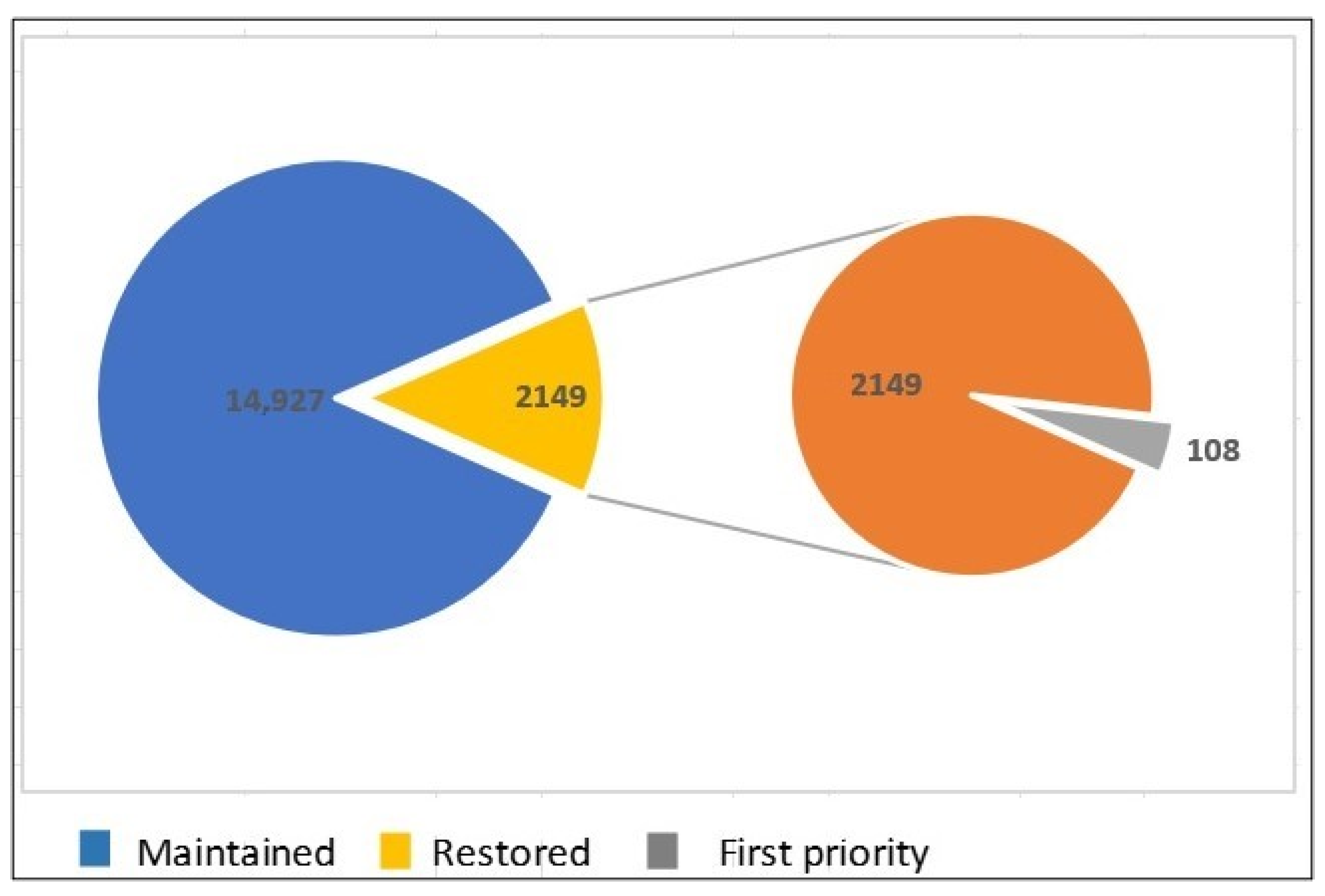
3.4. Big Failure and Success

Since it was implemented in 1967, watershed management has still failed, proven by the frequent occurrence of hydrometeorological disasters such as floods, landslides, and droughts [32]. Failures occur at the multi-stakeholder and community levels due to (1) a lack of stakeholder perception in understanding the impact of watershed management issues; (2) a lack of coordination between the officials in charge and the local government due to differences in watershed boundaries and administrative boundaries [33]; (3) a sectoral ego due to which watershed management problems are not handled thoroughly [34]; (4) the participation of government agencies in community empowerment being only incidental; (5) the implementation of activities using a project approach [35]; and (6) a lack of public awareness and knowledge about the importance of environmental protection [35,36].
The implementation of IWM encounters numerous obstacles, such as biophysical, socioeconomic, and institutional watershed issues. A new paradigm utilizing community participation strategies in IWM is expected to create a healthy watershed and to provide many ecosystem services [37,38]. IWM planning (RPDAS-T) is the main source of sectoral activities [39]. In addition, the use of natural resources must comply with various standards and regulations related to environmental protection [11].
However, there are success stories of watershed management, such as the Cidanau Watershed in Banten [31], Sumber Jaya in Lampung Province, Bungo in Jambi, Singkarak in West Sumatera, and Lombok in West Nusa Tenggara [40]. The success stories of watershed management have also been shown by indigenous people in managing forests, such as the Baduy tribe and Kasepuhan Ciptagelar in West Java, and the people of Muluy and Rantau Layung villages in East Kalimantan. This success was greatly influenced by the cultural characteristics of the community [41].

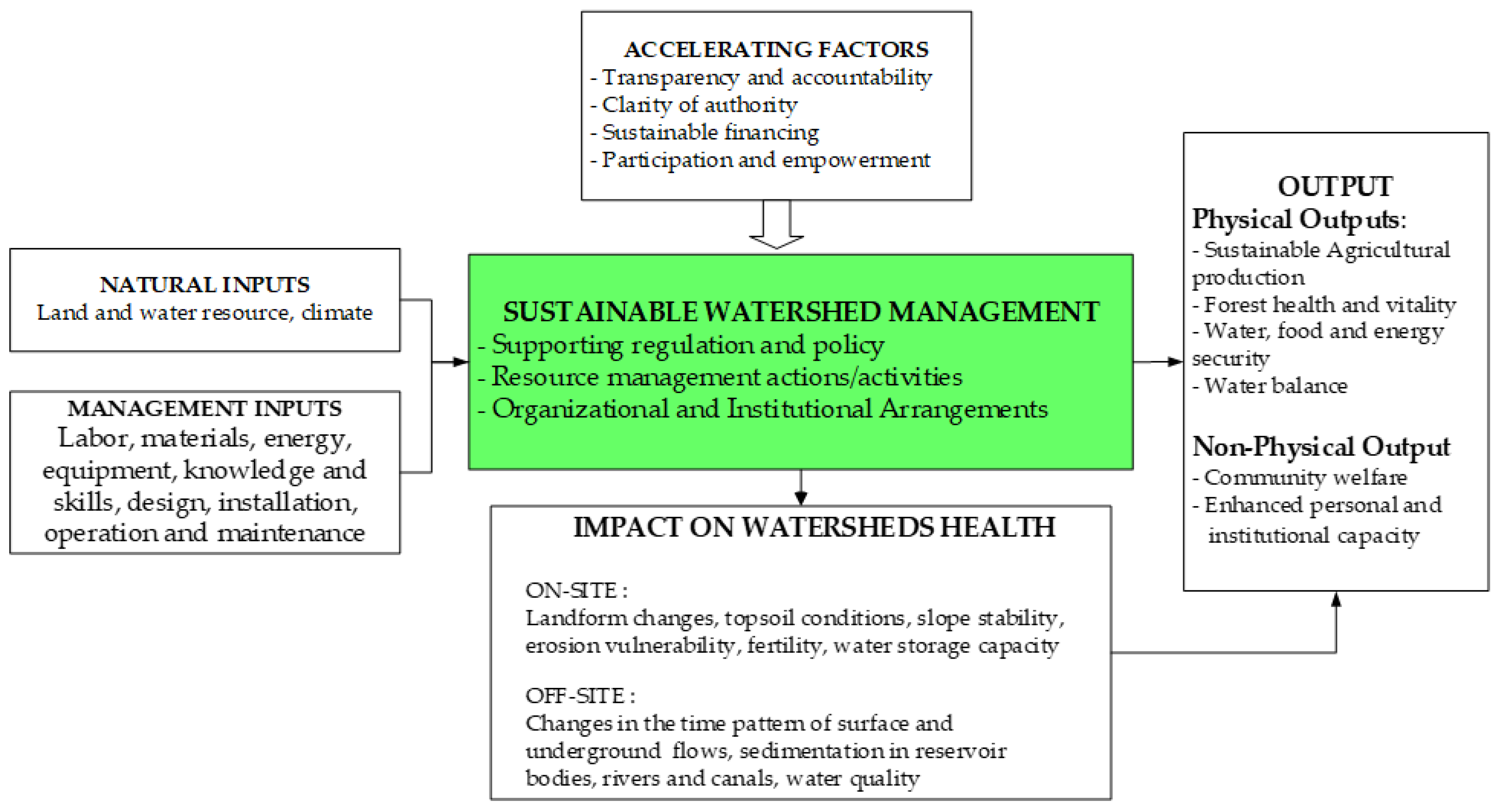
4. Sustainable Healthy and Productive Watershed: Parameters and Indicators

Watershed management is described as a process of formulating and implementing a series of actions involving natural resources and human resources, including social, political, economic, and institutional factors that are in and around the watershed and other related areas to achieve certain social goals [42]. Watershed management is carried out to produce the desired output by minimizing possible impacts (erosion, sedimentation, decreased fertility, etc.). Watershed management aims to plan and carry out watershed management actions to produce a healthy watershed to benefit all parties [43]. Meanwhile, under Law No. 37/2014 and Government Regulation No. 37/2012 on Watershed Management, watershed management aims to realize ecosystem sustainability and harmony and to increase the use of natural resources for humans sustainably. The characteristics of a sustainable watershed [44] are as follows:
  • Sustainable high productivity, including agriculture, trade, forestry, and recreation, as well as all management of existing resources that can guarantee a decent life;
  • Sustainable water yield, including quantity, quality, and distribution;
  • Equity, where all people are given the same opportunity to earn a decent income;
  • Resilience, in the sense that the shock of one location point in the watershed can be supported by other places. This resiliency is both described in terms of biophysical and socioeconomic factors.
Watershed health describes how well an ecological system is functioning. The biggest challenge is in determining the indicators. In general, indicators of a healthy watershed comprise the availability of water in adequate quantity and quality for various purposes; maintenance of soil fertility and land productivity; and a few hydrometeorological disasters such as floods, landslides, and droughts. Meanwhile, from various parameters of watershed characteristics, the United States Environmental Protection Agency (EPA) defines six main physical parameters as indicators of watershed health: (1) landscape conditions, (2) geomorphology, (3) hydrology, (4) water quality, (5) habitat, and (6) biological conditions [45]. The EPA uses various landscape data sets, country-reported water disturbance parameters, and monitoring of data to evaluate ecological and social indicators to determine watershed priorities that require protection or restoration [46,47].
To assess watershed health parameters, other studies have also been conducted to analyze hydrology and water quality by integrating watershed models and multi-criteria-based evaluation approaches [46]. Jun et al. [48] proposed a vulnerability index of water resources in the Bukhan River basin in South Korea to determine the spatial priority scale of watershed management to calculate the impact of climate change using the results of the HSPF (hydrological simulation program FORTRAN) model. Zhao et al. [49] used a SWAT (soil and water assessment tool) model with six indicators, including total nitrogen exports and total phosphorus exports, to evaluate the restoration priorities of the riparian buffer zones in the Liuxihe River basin in southern China. Shen et al. [50] designed a framework for identifying priority areas for Daning River watershed management in China by calculating pollution emissions from different areas and their effect on the quality of nearby water bodies using a SWAT model. Meanwhile, Chung et al. [51] developed an indicator-based multi-criteria approach to assess the vulnerability of water resources in the sub-WATERSHED and applied it to the Han Watershed using the SWAT model and a technique for determining the order of preference similar to that of the ideal solution (TOPSIS) approach.
A healthy watershed produces good-quality water and provides other greater goods and services to the people and wildlife that live there. The range of ecosystem services encompasses water filtering and storage, air filtration, carbon sequestration, nutrient cycling, soil genesis, recreational opportunities, food provision, and wood production. A considerable number of these services have yet to be priced, resulting in the frequent undervaluation of the economic contributions provided by robust and intact ecosystems throughout land use decision-making processes. Streams, reservoirs, lakes, and other water bodies are interconnected with the landscape and all their activities through the hydrological system. The dynamics of the relationship between land and water will greatly determine the health of the watercourses and the life within them. The preservation of intact watersheds is crucial in order to safeguard the significant ecosystem services that provide economic benefits to society and mitigate the need for costly replacement and restoration efforts. Maintaining riparian connectivity and natural processes in the landscape provides a support network for ecological integrity, ensuring a sustainable and cost-effective provision of clean water over time [52].

5. Existing Practices and Lessons Learned

5.1. Landscape Management

Integrated landscape management supports various goals, including food production, livelihoods, dietary health, social fairness, and climate change mitigation adaptation [53]. In Indonesia, the perspective of the landscape approach has been expanded and integrated into the perspective of the watershed management unit. The landscape condition is an indicator of a healthy watershed in addition to several other indicators such as habitat condition, hydrology, geomorphology, water quality, biological condition, and vulnerability [54], including the dynamics of the changes in the structure and function of the landscape in the form of land use and land cover.
Watershed management is a holistic effort that monitors hydrological relationships between upstream and downstream areas in managing land, water, and natural resources with broad dynamics of anthropogenic interactions [55,56]. Watershed management can be divided into four parts, namely (a) planning, (b) implementation, (c) monitoring and evaluation of watershed performance, and (d) assistance and supervision (Government Regulation No. 37/2012). However, in Indonesia, watershed management—as a form of natural resource landscape management—still faces complex problems due to the diversity of ecosystems, the involvement of many institutions/stakeholders, and spatial challenges across ecosystems and administrative regions [4].
Landscape management, in terms of watershed scale, is still experiencing various obstacles. In terms of planning, integration between authorized agencies is still lacking. The MoEF prepared an Integrated Watershed Management Plan (RPDAST), while the Ministry of PWH prepared a Water Resources Management Plan, both of which do not involve regional governments [39]. From an implementation perspective, the management of each watershed is unique and cannot be applied equally to all watersheds. This is because, in addition to varying in area from thousands of square kilometers to only thousands of hectares [13], watershed management must also consider the heterogeneity of landscape characteristics in the watersheds [57], such as soil properties; vegetation components related to water consumption, geomorphology, precipitation [57,58,59]; and socioeconomic and institutional factors [13]. In terms of monitoring and evaluation, the obstacles encountered are as follows: (1) coordination is only carried out by the MoEF and does not involve other stakeholders, (2) monitoring and evaluation results have not been used to improve watershed management plans for future years, and (3) integrated monitoring outlets are difficult to determine due to the different processes of planning and implementation of each institution.
Citarum is an example of difficulty in managing an enormous watershed (approx. 9000 square km). Citarum River’s water quality is poor due to the pollution from households, agricultural activities, fisheries, industry, and livestock waste [60,61], as well as land degradation due to land cover changes [62,63]. The issuance of the Presidential Decree Number 15/ 2018 on the Acceleration of Pollution Control and Damage to the Citarum River Basin cannot solve the problems due to a lack of facilitators, a lack of government budget, and a weak negotiating position toward business owners, coupled with lacking adequate academic reviews [64].

5.1.1. Upstream Watersheds

The Mountain Tropical Region (MTR) is the main source of water and plays an important role in food security in the tropics. MTR forests have very good benefits, including significance in the process of the hydrological cycle; regulating air humidity; reducing erosion and sedimentation; and providing important resources, both timber and non-timber. Multiple threats against MTR include land clearing, excessive exploitation of natural resources, increasing population, and natural events such as earthquakes and volcanic eruptions. MTR management must pay attention to the highest-priority strategy, and effective communication between stakeholders must be urgently improved. Damage to natural forests is characterized by degradation and deforestation. Degradation can be seen from the reduced crown cover to the changes in forest structure from shrubs to tall trees. Forest damage can be caused by natural factors such as forest fires, climate change, pests, and diseases. It is estimated that 30% (or around 34 million hectares) of Indonesia’s natural forests have been degraded [65]. The threat of forests will distract their function as water producers, carbon sinks, and habitats for various animals. The impact of various activities along the river flow has caused a decrease in the level of dissolved oxygen in the water; therefore, this will cause marine biota, such as fish, to experience a lack of oxygen and subsequent death.

5.1.2. Micro-Watersheds

A regulation from the Director General of Land Rehabilitation and Social Forestry (Perdirjen RLPS) No. P.15/V-SET/2009 on micro-watershed management was issued for micro-sized watersheds (<5000 ha). Since it was developed in an upstream area, the existence of a micro-watershed is very appropriate in protecting water catchment areas, which are usually highly vulnerable to degradation. The advantages of micro-watershed management are as follows: (1) statistically, it will reduce its complexity in terms of ecological, institutional, social, and community aspects; (2) coordination and synchronization between institutions and stakeholders is relatively easy; therefore, the planning, implementation, monitoring, and evaluation processes can run well in an integrated manner; (3) the data used are spatially more detailed, problems become easier to identify, the location of problems become easier to determine, and technical and institutional solutions become easier to find.
The concept of micro-watershed management can be a way out of watershed management problems in Indonesia, as suggested by Narendra, Siregar, Dharmawan, Sukmana, Pratiwi, Pramono, Basuki, Nugroho, Supangat, Purwanto, Setiawan, Nandini, Ulya, Arifanti, and Yuwati [4]. The results of the research conducted by Supangat et al. [66] provide several lessons learned: (1) detailed basic data on the potential and characteristics of micro-watersheds are important; (2) the micro-watershed management planning process requires a combination of “top-down” and participatory systems; (3) “top-down” planning can be used as a guideline for good land management upstream from a watershed; (4) participatory planning should be carried out when preparing land use plans and determining the types of community contribution; and (5) a collaborative plan with related stakeholders is needed to integrate and maintain micro-watershed management activities.

5.2. Soil and Water Conservation

Soil and water conservation activities, through coordination, participation, and collaboration with various parties, can produce healthy and productive watersheds [11,67]. In soil and water conservation activities, vegetative techniques through planting woody plants, shrubs, grasses, and other types of conservation plants [68] can be carried out through cropping pattern arrangements, i.e., agroforestry or community forests, mixed gardens, silvopasture systems, alley cropping systems, and contour hedgerows [4,69]. Mechanical techniques are applied to various constructions, i.e., swales, ridges (guludan), bench terraces, control dams, retaining dams, mud pits (rorak), drainage channels, infiltration wells, and gabions [68]. The selection of a mechanical technique is based on the existing problems, such as runoff, landslides, or sedimentation, as well as based on the watershed location, i.e., upstream from, middle of, or downstream from the watershed [4]. The application of terraces, such as bench terraces and ridge terraces, is still effective in reducing erosion [69,70,71,72] and increasing farmers’ income [73]. To reduce the cost of implementing soil and water conservation techniques mechanically, which are generally expensive, it is necessary to utilize local materials that are cheaper and easier to obtain, as well as to foster cooperation between farmers during their implementation using incentives from the government.
Agroforestry is one of the best soil and water conservation practices in Indonesia from an ecological and economic perspective [11] since it can reduce surface runoff and erosion [11,74] by 67% and 80%, respectively, compared to land without conservation measures [75]. The infiltration capacity in agroforestry systems is also higher than that of intensive farming systems, namely 479 mm/hour and 315 mm/hour in the Serayu Watershed, Central Java Province [76]. Around Mount Merapi in Central Java, agroforestry conserves soil and water while increasing income and providing food for the community [77]. In Gowa, South Sulawesi, a mixture of trees and coffee in an agroforestry system is used for the reforestation of degraded land [78]. The combination of agroforestry systems and local wisdom is an appropriate choice to increase the effectiveness of reducing surface runoff and erosion and to ensure the sustainability of soil and water conservation practices [79,80].
Various types of soil and water conservation practices have not fully guaranteed healthy and productive watersheds throughout Indonesia. This is because the application of these techniques has not been carried out systematically and integrated by related parties, such as the government, the private sector, and the community [81]. Narendra, Siregar, Dharmawan, Sukmana, Pratiwi, Pramono, Basuki, Nugroho, Supangat, Purwanto, Setiawan, Nandini, Ulya, Arifanti, and Yuwati [4] state that community participation is the key to success in soil and water conservation practices. Several points related to the importance of community participation in soil and water conservation need to be considered: (1) the government and private community, religious, traditional, youth, female, and other figures can raise public awareness to actively participate in various programs [82]; (2) the implementation of soil and water conservation needs to be carried out based on local wisdom to ensure sustainability [83]; (3) community participation can increase with innovative programs that can improve the community’s economy [84]; and (4) community capacity building is positively correlated with program sustainability [85]. In 2022, the Directorate of Soil and Water Conservation applied mechanical techniques by constructing 2985 units of soil and water conservation buildings consisting of 983 units of retaining dams and 2002 units of gully plugs, as well as vegetative techniques by holders of the Forest Land Use Agreements (PPKH) covering an area of 18,498.36 Ha.

5.2.1. Vegetative Rehabilitation through Reforestation and Afforestation

Reforestation is important due to its capability to protect life support systems such as regulating water systems, preventing flooding, controlling erosion, preventing seawater intrusion, maintaining soil fertility, and stopping the loss of biodiversity worldwide and the effects of climate change [65,86,87,88]. Afforestation is considered the formation of new forests in open areas, selective logging locations, or other empty land in forest areas. Forest renewal is thus the formation of new forests or replanting of forest areas that have been cleared and vacant land located within forest areas [89]. Reforestation’s key advantage is that it protects the ecosystem and the forest, which play key roles in maintaining life on Earth [90]. Forest restoration aims to return damaged ecosystems to their original state via a process that balances reforestation and deforestation to enable us to live on the planet sustainably [86].
One of the programs to save the forestry environment outside of a forest area is a reforestation and soil conservation program called One Million Tree Planting Day, which is one of the many efforts aiming to mobilize the community to protect the environment through a watershed ecosystem approach every year [91].
Besides nature reserves and core zones of national parks, degraded land within a watershed is a priority for land and forest rehabilitation. Priority is given to upstream watersheds due to their vulnerability to floods, droughts, and landslides. Upstream watersheds are also prioritized due to their catchment areas for reservoirs, dams, and lakes, recharge areas, river border areas, springs, lakes, and reservoirs, as well as their vulnerability to downstream watersheds that are vulnerable to tsunamis, seawater intrusion, and river abrasion. Table 2 shows the efforts for restoring forests and land from 2015 to 2021 [87], with 1163 gully plugs and 391 retaining dams constructed.
Restoration strategies must be tailored to the location, including species choice, planting season, and project schedule. Socioeconomic elements are crucial for restoring the forest environment during the restoration phase. The community can be involved in various ways, such as hiring locals for restoration projects. A standardized framework for direct choice making and effective forest restoration is proposed to boost the success of forest restoration, to enhance sustainability, and to enable the survival of forested landscapes.

5.2.2. Coastal Rehabilitation

Due to an increasing propensity for people to reside near the coast, especially in Indonesia, managing coastal development in hazardous regions has now become a serious problem. Nevertheless, coastal risks are frequently ignored until they harm the coastal areas significantly [92]. Semarang, Tegal, and Demak, three significant cities in Central Java, are struggling with severe coastal erosion issues. A historical shoreline change study helps to understand the trends in erosion and sedimentation, allows for some shoreline movement forecasting, and helps to understand the dynamics and processes of coastal erosion. Although physical and structural mitigation strategies have been successful in Semarang, Tegal, and Demak, they could not completely resolve the issue of coastal erosion in those areas [93].

5.2.3. Mangrove Rehabilitation

In Indonesia, at least three different planting designs—square, zigzag, and cluster—and eight different planting methods are used to restore destroyed mangrove ecosystems. These include the “banjar harian” technique, the “bamboo pole technique”, the “guludan technique”, the “water break technique”, the “huge polybag technique”, the “ditch muddy technique”, the “huge mole technique”, and the “cluster technique”. Rhizophora species are typically utilized for mangrove rehabilitation and/or restoration, with a 1 × 1 m spacing and a range of planting costs depending on the site’s local conditions and the planting method employed. Mangroves were planted from approximately IDR 14.2 million using propagules to IDR 18.5 million using cultured seedlings. The local population recently employed agroforestry techniques to utilize the mangrove ecosystem for many purposes and the related aquatic fauna to sustain their everyday lives (silvofishery, agrosilvofishery, and agrosilvopastoralfishery systems). Hence, a healthy mangrove ecosystem supports an array of luxuriant plant and animal species, which greatly contributes to the wellbeing of coastal communities [94].
Mangrove ecosystem protection strategies are crucial for long-term mangrove management and support the national blue carbon agenda. Indonesia has set a highly challenging mangrove restoration target of 600,000 ha, which must be completed by 2024 to meet the Sustainable Development Goals. Improvements in monitoring, assessment, and sub-national government representation can increase the likelihood of achieving mangrove rehabilitation objectives and reduce the risks of failure.

5.2.4. Peatland Ecosystem Restoration

The restoration of peatland ecosystems involves integrating communities and encouraging the private sector to restore their concession areas. The fundamental tenets of the restoration of peatland ecosystems include bettering water management through the construction of rewetting infrastructure; rehabilitating vegetation; and enhancing people’s social, cultural, and economic wellbeing and livelihoods (revitalization).
In Indonesia, peat swamp forests were first restored in the late 1960s due to large-scale government initiatives (such as transmigration and the mega-rice project), unregulated legal logging in concessions, and substantial illicit logging, all contributing to the depletion of forests. Drainage canals were constructed to promote agricultural growth and timber transportation, causing vast sections of peatland to be drained, leaving them dry and thus fanning flames. To suppress fires and to begin replanting, the restoration of degraded peatlands typically begins with raising the water table. Techniques for obstructing canals could be used to achieve this [95].

5.3. Flood and Drought

A healthy watershed is reflected in its ability to maintain river discharge in a constant state, which means there will be no droughts during the dry season or flooding during the rainy season. Unfortunately, as a tropical country that experiences two seasons, rainy and dry, Indonesia is very vulnerable to disasters caused by these two seasons, namely floods and landslides during the rainy season and droughts during the dry season. Apart from the effects of climate change, the increasingly frequent occurrence of floods and droughts shows that most watersheds in Indonesia are not healthy.
Floods are the most frequent disaster in Indonesia, with the National Board for Disaster Management (BNPB) having recorded more than 300 flood events as of the end of March 2023. On the other hand, as of 31 March 2023, there have been no reports of droughts in Indonesia. Although not as often reported as floods, droughts can cause other disasters, such as forest fires, which occurred 272 times in 2022. Those disasters show that efforts should be made to improve the health of the watersheds as well as to reduce floods and droughts.
Floods and droughts are disasters that occur one after another. The causes of droughts are the same as the factors that cause floods [96]. Both droughts and floods are caused by natural factors and a combination of natural factors and human factors [97]. The natural factor for both disasters is precipitation, too much or too little rainfall. The human factors for floods can be in the form of land cover changes [98,99]; an increase in impermeable areas [97]; an expansion of urban areas [100]; or tidal floods in coastal areas [101], which causes an increase in surface runoff and results in flooding.
Mitigation is an attempt to reduce the impacts of disasters and can be in the form of structural and non-structural mitigation [77,102,103]. Structural mitigation is carried out by using a technological approach and through the construction of physical infrastructure such as the construction of embankments, river canals, and dams/reservoirs; afforestation and reforestation; the construction of terraces; the maintenance of water springs; and the construction of ponds, rainwater reservoirs, and infiltration wells [102,103,104,105,106]. Non-structural mitigation includes mapping disaster-prone areas; constructing rules and policies; strengthening community capacity through training, education, and extension; forming working groups; and building a network among stakeholders [102,103]. Therefore, the mitigation carried out must be based on the level of hazard, vulnerability, and risk from both physical and social aspects [103,107]. However, the mitigation carried out cannot be generalized for all regions, although the same forms of mitigation may be used for several regions.
Structurally, several soil conservation techniques are designed to minimize runoff, and bio-pores are one of them. Bio-pore holes are a technique to reduce surface runoff [69], as well as soil erosion and sedimentation. It can be applied in densely populated residential areas [108] and in line with the development of green open spaces [109]. Furthermore, according to Aji and Palupi [110], the benefits of bio-pore holes include increasing water absorption; improving groundwater quality, as a place for organic waste disposal; converting organic waste into compost; increasing the role of soil fauna and plant roots activities; preventing flooding; and overcoming problems caused by standing water.
A silt pit (rorak) is another method to reduce runoff as well as erosion [69,111,112]. The dimensions and the number of silt pits are calculated based on the potential for surface runoff in the field [113]. In the urban area, when most of the surface area is impermeable, the use of infiltration wells is recommended. An infiltration well is an artificial hole that functions as a reservoir for surface runoff as well as increases in groundwater [69], does not require a large area of land, does not require expensive costs to manufacture, and is an environmentally friendly environment [114]. Siahaan and Kusuma [115] gave some criteria regarding the determination of the location of an infiltration well: 1. the well should be placed on relatively flat land; 2. the water should originate from rainwater that is not polluted; 3. the safety of the surrounding buildings must be considered; 4. the minimum groundwater depth should be 1.5 m during the rainy season; 5. the soil permeability value should be ≥2 cm/hour; and 6. groundwater contour should occur naturally, with ground water entering the soil layer easily.

5.4. Urban Planning, Pollution, and Waste Control

In contrast to watersheds in rural areas, river pollution, waste, and garbage greatly affect the health of watersheds in urban areas. Pollution in urban rivers comes from household waste, agricultural activities, and industrial activities. Pollution due to household activities can be seen from the amount of ammonia and phosphate; detergents; microplastics; oil; grease; and microbial contamination, including E. coli bacteria, which exceed their thresholds [116,117,118,119]. Various studies show that rivers in Indonesia that pass through big cities such as Brantas, Bengawan Solo, Ciliwung, Citarum, and Citanduy have experienced pollution ranging from low to severe levels [120]. For example, Jakarta, the largest city in Indonesia, whose rivers are often discussed by various parties with regard to water pollution, contributes 75% of the domestic waste in urban water pollution [121]. As the second largest city, Surabaya also experiences water pollution problems from domestic waste, particularly in the Brantas River [121]. Like Jakarta and Surabaya, Bandung also experiences water pollution, of which 80% comes from domestic waste [121]; even the Citarum River is one of the most polluted rivers in the world [122].
On the other hand, pollution originating from agricultural activities comes from residues of fertilizers, pesticides, or livestock manure that enter water bodies and can be seen from the amount of dissolved nitrogen (N) and phosphate (P) in the river flowing from upstream to downstream [123,124]. River pollution originating from industrial processes usually contains heavy metals such as lead, mercury, zinc, nickel, chromium, cadmium, oil, and grease [122,125], increasing BOD and COD levels and lowering water pH [126]. Most of these pollutants come from the textile, food and beverage, wood processing, pharmaceutical, manufacturing, and leather industries in the watersheds, especially in Java [122].
Because it is a serious concern, especially in big cities, waste management is a priority to be carried out in various places. Currently, many parties, both government and non-governmental organizations, are starting to clean up the trash and waste from river bodies. The government has been concerned about river cleanness for a long time, strengthened by the Decree of the Minister of Environment No. 35/1995 on the Clean River Program (PROKASIH). This decree aims to improve the function of the river by supporting sustainable development and controlling water pollution [127]. The main target of river cleaning activities is to dispose of domestic waste, especially plastic found in the river bodies. Some of the rivers that are the targets of PROKASIH include Cisadane, Ciliwung, Citarum, Brantas, Bengawan Solo, Siak, Code, Winongo, and Gajah Wong. In addition to government initiatives, there have been various clean river actions, such as those carried out in the Brantas Action (initiated by the Makara Institute) and the Clean Ciliwung Movement (conducted by the Ciliwung Caring Community). In line with the PROKASIH program and river restoration, 63 river observer communities have been formed, which are at the forefront of river pollution control, both through river clean actions and providing non-formal schools to raise public awareness of river cleanliness and sustainability [128]. Some of these communities are Pemerhati Kali Code Yogyakarta, Winongo Asri Yogyakarta Communication Forum, Sabo Jenenberang Community Forum, Makassar, Santri Jogokali Jombang, KPS Batu Bulan Ambon Maluku, and West Papua River Lovers Forum.

5.5. Payment for Ecosystem Services (PES)

The environmental services offered by a healthy watershed include the use of water for domestic and industrial purposes; for electric power; and as scenery, providing benefits in the form of ecotourism [129,130,131]. Water yield and water quality directly impact the source of income derived from the utilization of environmental services (PES), the most frequently suggested initiative in Asia regarding compensation for ecosystem services.
The demand for water and population growth continue to increase [132], and water is still a common good that is easily accessible to the public today, although it has shifted into a commercial good under the supervision of certain corporate sectors [133]. Proper arrangements must be made since these changes may create a conflict of interest [134,135]. This change increases the understanding of the value of ecosystem services that suddenly disappear when they are not free, and this makes the value of the ecosystem even more recognized. Several water services that have been utilized involve the Cisadane watershed [136], the Upper Kapuas river basin [137], the Musi watershed [138], the Upper Brantas watershed [139], Lake Sentarum [137], the upper Banjaran Sub-watershed [140], and the upper Cangkok and Banjaran Sub-watersheds [141].
Anthropogenic factors are the most important variables that impact how ecosystems provide environmental services [142]. Some human activities can damage the ecosystem, e.g., pollution from urban development [143,144], intensive land use changes that degrade watersheds and reduce water yields [145,146,147], and population pressure on land that causes degradation [148,149]. Due to environmental degradation, ecosystem services can become inaccessible and may require expensive restoration measures. One initiative to restore ecosystem functions is PES, which started in the mid-1990s. PES is the provision of environmental services used to finance ecosystem protection so that it can be used sustainably in many nations, particularly in Asia, the USA, Australia, and Costa Rica [130,150]. In Indonesia, PES refers to relationships with water and forests [151,152,153,154]. Entrepreneurs make payments for the ecosystem services used, such as PT Indonesia Asahan Aluminium in Noth Sumatra; PT Krakatau Tirta Industri in Banten Province; PT Aetra in West Java; and District Drinking Water Company (PDAM) in Lombok, West Kalimantan, and Aceh [129,155]. The collected funds are used to improve the ecosystems around the water sources so that ecosystem services can be utilized sustainably. West Nusa Tenggara and South Sumatra are regions that already have regulations related to PES [129,138].
The implementation of the PES program in Indonesia has experienced several challenges, such as (1) a lack of financial resources to fund PES programs [155], (2) a lack of legal frameworks and institutional capacity [156], (3) constraints on the coordination and synchronization of authority among stakeholders [155], and (4) a lack of public participation [157]. To address these challenges, (1) the Indonesian government needs to strengthen its legal framework for the development and implementation of the PES program (through Government Regulation No. 46/2017 on Environmental Economic Instruments); (2) increase funding for PES programs; (3) increase stakeholder involvement, especially community participation, and (4) increase capacity building among PES program participants. The Cidanau Watershed Forum is an example of a forum that has implemented PES in utilizing Cidanau Lake water. Its main activity is the mediation of payments for water environmental services that are utilized by the downstream private sector and upstream farmers. Payment for environmental services ensures the sustainability of community forests belonging to the community upstream from the Cidanau watershed.

5.6. Community Engagement

The success of sustainable watershed management involves all stakeholders, including local communities, who are directly affected by every decision made [158]. Empowering the local community with a great deal of knowledge regarding the nature, culture, and history of the area they settled in [159,160,161] will help identify the physical, biological, and cultural aspects that require protection [162]. Community engagement entails the active participation of the local communities in the decision-making processes [163,164] so that they gain a sense of ownership and responsibility for the natural resources and can better manage those resources [161,165,166]. Community engagement can also streamline communication between stakeholders and decision-makers, as well as address environmental justice challenges that have plagued local communities for decades [161,163].
Successful community engagement in watershed management requires a process that brings together stakeholders, including government agencies, non-profit organizations, and community groups [160,167]. Community participation can include various activities, such as education and training, citizen science, and volunteering, and can take the form of public meetings, seminars, and outreach initiatives. The low success of community involvement is due to distrust of the government and community economic pragmatism [168]. In the Keduang sub-watershed, Bengawan Solo watershed, research has shown that community empowerment efforts in various land rehabilitation and soil conservation programs through the provision of seeds, fertilizers, and subsidies have been less successful because the species determined by the government are not compatible with the physical and environmental conditions and local community needs. Additionally, research in three micro-catchments in the Keduang sub-watershed also showed that community participation in watershed management is only in the form of consultative participation and participation that is mobilized by incentives or assistance [169]. The use of a dry land agroecosystem (DLA) for seasonal crop farming in Java has caused severe damage due to rural communities' lack of ability to manage DLAs and the inaccuracy of government policies in building community empowerment models [170].
Some of the weaknesses of the community engagement process in watershed management are the use of a project approach, which tends to be top-down, and community involvement being limited to consultations/public hearings. Burgin [171] agrees that engaging communities through consultation with selected representatives of key groups to identify a single champion in the watershed management process is unlikely to be successful. Bach, Clausen, Trang, Emerton, Facon, Hofer, Lazarus, Muziol, Noble, Schill, Sisouvanh, Wensley, and Whiting [158] underlined that the participation of local communities is very crucial, as they are the ones most impacted by management decisions made at larger scales.
Community engagement in watershed management is challenging because the benefits are obtained in the long term and are received not only by the activity actors (on-site) but also by the downstream community (off-site). In a collective action, binding social capital [172], cooperation and community trust [173], and charismatic leadership [166] play important roles in increasing the possibility of a community understanding the objectives of natural resource management, empowerment, and two-way communication.
The MoEF has conducted research and development in community-based watershed management in South Sulawesi province to create healthy and productive watersheds at the micro-watershed level. The objectives of this micro-watershed management model consist of five objectives: (1) erosion and sediment control; (2) water-yield enhancement; (3) land productivity enhancement; (4) increased income; (5) increased awareness, concern, and participation, and (6) community capacity building at the personal and community organizational levels. In general, the community-based micro-watershed management model is described in Figure 4.
Micro-watershed management was carried out within the framework of community-based forest management (CBFM) as the main strategy. Following the CBFM strategy, micro-watershed management is carried out within the framework of sustainable forest management, with the target of meeting the needs for food, shelter, water, and electricity independently based on three main strategies, namely (1) area management strategy, (2) institutional management strategy, and (3) business management strategy, as follows:
  • Area management is a series of pre-condition activities carried out to support the implementation of community empowerment activities to optimize the use of existing resources in a watershed, including forest areas and resources, which include reserves such as boundary delineation; mapping; the determination of community empowerment work areas; and other activities, which include land use stewardship, forest protection, soil rehabilitation, and conservation.
  • Institutional management is a series of efforts in the context of optimizing the implementation of community empowerment by establishing the rules of the game, strengthening the organization, and increasing the human resource capacity.
  • Business management is a series of activities that support the growth and development of businesses in community empowerment through partnerships considering the responsibilities and benefits. The forestry business system in CBFM is a system that not only is in the form of cultivation but also includes the downstream sector, namely industry and marketing.
Those three main strategies are implemented in three major activities: (1) implementing forest and land rehabilitation and soil and water conservation, (2) developing the use of water resources for community welfare, and (3) fostering and facilitating community institutions.

5.7. Data and Information Management

Managing data and information on watersheds in Indonesia has evolved significantly over the past few decades. In the past, watershed data and information management in Indonesia only focused on hydrological data, such as streamflow, rainfall, and water quality. Initially, conventional measurement methods were used [174]. For example, water quality monitoring based on traditional field-laboratory-based measurements consisted of several stages: collecting a water sample manually, transporting the sample to the laboratory, conducting the analysis, and summarizing the water quality results.
However, in recent years, there has been a growing recognition of the need for a more integrated and comprehensive approach to watershed management, covering a wider range of data and information needs. From the point of view of a healthy and productive watershed, data and information should at least cover geomorphology; water quality, quantity and distribution; landscape; and habitat conditions in the watershed [45]. The increasing complexity of environmental problems in Indonesia, such as deforestation, land use change, and climate change, also drives this condition. Therefore, the use of recent technologies in data and information management is needed.

6. Key Strategies in Achieving Sustainability and Recommendations for Handling the Impact of Climate Change

From the lessons learned discussed in the previous section, we formulated three main elements of management to achieve a sustainable healthy and productive watershed: regulatory support, resource management actions, and organization and institution arrangement. These three elements must be seen as a unit. If one element is not optimal, then the whole system will fail. However, these three elements can run sustainably if there are physical and management inputs with the support of catalytic factors, namely transparency and accountability, clarity of authority, sustainable financing, and public participation and empowerment. A general rational watershed management system regarding physical and non-physical outputs is simplified in Figure 5.
The key strategies to achieve healthy and productive watersheds are described in the following sections. These strategies are also recommendations for mitigating climate change impacts and realizing sustainable watersheds.

6.1. Regulatory and Policy Support

Regulatory and policy support for sustainable watershed management to ensure the long-term health and productivity of watershed ecosystems needs to be carried out through a series of activities: (1) existing regulation and policy evaluation, (2) goal definition, (3) scientific evidence collection, (4) regulation and policy development, and (5) policy implementation and enforcement

6.2. Appropriate Resource Management Action

6.2.1. Ecosystem Conservation

Natural habitats within watersheds, such as forests, wetlands, and riparian areas, which play important roles in maintaining the quantity, quality, and distribution of water products and providing habitats for biodiversity, should be protected and restored [175]. Preserving woody plants or forests in forests, wetlands, and riparian areas is crucial to ensuring the availability of clean and safe drinking water since their coverage within a watershed affects the cost of delivering drinking water [176]. Optimizing land use in spatial planning, forest cover particularly, is crucial to meeting multiple ecosystem services, i.e., water, agricultural and forest products, and energy [177]. The key to success in ecosystem conservation practices for achieving healthy and productive watersheds is prioritizing the synergy between services and avoiding trade-offs between services. A trade-off occurs when human intervention improves the output of an ecosystem service, inversely lowering the output of another service [178]. Modifying the method of ecosystem management by enhancing the spatial linkages between various ecosystem services could improve watershed resilience [176] to the impacts of climate change.

6.2.2. Sustainable Land Use Practices

Sustainable land use practices should be promoted by minimizing soil erosion, reducing runoff, preventing soil and water pollution through precision farming and agroforestry, promoting the use of organic matter, and applying soil and water conservation techniques to achieve healthy and productive soils. Land use changes from forests to agricultural land significantly increase soil erosion. A global prediction for land cover change was that a reduction in forests by 4.1% into agricultural land would cause an increase in soil erosion by about 52%, while the conversion of 15.3% of observed croplands into agricultural land reduces soil erosion by 7% compared to the baseline [179].
An improvement in sustainable land use practices to reduce the environmental impact of climate change can be realized by applying precision farming. This farming system refers to using sustainable tools and information technology to increase efficiency and productivity and to offer more in-depth knowledge on effective agricultural management to farmers [180]. Precision farming promises a better working environment, a more profitable use of resources, a decrease in environmental stresses, and a higher level of profitability [181]. The key concept of precision farming is site-specific management, so the appropriate treatment must be applied in a suitable location at the right time [182]. Optimization is attained by considering the crop rotation effects, site qualities, moisture content, pest and weed concerns, and weather forecasts [181].

6.2.3. Water Use Management

Severe climate change will disturb the hydrological cycle and reduce water availability. Consequently, proper water use management, particularly water use efficiency, is essential. It can be approached through physical, social, and economic aspects. Physical aspects include building and maintaining water infrastructures such as dams, irrigation systems, reservoirs, and pipelines [183]. Controlling and maintaining water infrastructure networks are essential because they can detect and improve water leakage and efficiency [184]. The application of advanced technology is also a key factor in achieving a healthy watershed [185]. Using innovative technology, i.e., low-flow shower heads, low-flush toilets, and water-saving washing machines, can reduce water use [184], as can water filtration methods, water purification, and desalination [183]. Water harvesting from rainfall is a type of water management [183].
Water use efficiency can be achieved by encouraging efficient domestic, industrial, and agricultural water use practices with water-saving technologies and wastewater treatment, including the implementation of measures to reduce and control watershed pollution by minimizing the potential for point source and non-point source pollutants and protecting water sources [183].
Increasing water use efficiency may also be achieved via tariff reform [183,184,186] and tax policies for water resources [187]. The application of a tax policy and tariff reform must take into consideration the social–economic aspects of the communities. These should preserve social equity and, at the same time, guarantee the sustainability of water services and investments [186]. Equal opportunity should be applied to the upper and lower watersheds, high and low income, poor and rich people, and urban and rural [55].
With regard to the impact of climate change, water use efficiency is a crucial factor in the dry season. Rainwater harvesting (RWH) techniques for agriculture or daily consumption are one way to deal with drought. Technically, RWH can be in the form of embung (on-farm reservoir), check dams, channel reservoirs, or infiltration ditches [188,189]. RWH can also be in the form of “Akuifer Buatan dan Simpanan Air Hujan”/ABSAH (Artificial Aquifer and Rainwater Storage). ABSAH is a water supply building made to be tightly closed so that rainwater can be stored and flows into an artificial aquifer and then stored in a reservoir [104]. The other benefits of implementing RWH include saving water during the rainy season, using it in the dry season, and replenishing groundwater. Other SWCs for drought mitigation include drip irrigation, mulching, silt pits, and soil moisture retention [69]. Traditional knowledge of drought mitigation has been used in Nusa Penida Island, Bali [190]; Central Java [104,106]; and Maros watershed, South Sulawesi; as well as Moyo watershed, West Nusa Tenggara [107,191].
Drought forecasting and early warning are essential non-structural forms of drought mitigation. Several methods have been developed and implemented in Indonesia for forecasting and early warning purposes. For example, Tallar and Dhian [192] employed the Drought Vulnerability Index (DVI); the Standardized Runoff Index (SRI) was used by Auliyani et al. [193], Primadita et al. [194] utilized the Drought Vulnerability Level the with rainfall, evapotranspiration, geology, landform, and water source parameters; a regional frequency analysis was used by Kuswanto et al. [195]; and spatial and temporal analyses were used by Bashit et al. [196]. The outputs from drought forecasting have been employed for early drought warning systems. These systems help decision-makers to take appropriate actions, such as water rationing, crop insurance, and emergency relief [197]; to determine cropping patterns considering water availability; to promote for water-saving movements; and to monitor and evaluate efforts dealing with droughts [103].

6.2.4. Public Knowledge and Awareness

Public participation should be promoted through campaigns to increase understanding and positive attitudes towards watersheds to increase awareness of the importance of sustainable water management practices and to encourage individual and community participation. Learning to use water sustainably for domestic purposes can be achieved from childhood via education in schools and promotion in the community in general through discussion forums or television, the radio, YouTube, and leaflets.
A key action to speed up knowledge transfer is to provide fresh ideas and methods for managing sustainable water use to educational institutions [186]. The related government institutes, governmental entities, and NGOs should support and coordinate a nationwide long-term educational, cultural, and information campaign to raise awareness of water use efficiency [184,186].
To achieve sustainability in terms of healthy and productive watershed, a top-down approach must be accompanied using a bottom-up approach that involves the community [67,158,165,171], and the community must be involved from the early stages of determining the program goals and objectives [161,166]. Thus, efforts to increase public understanding of watershed management and the upstream–downstream relationships in a watershed are urgently needed, in addition to increasing community confidence in expressing opinions [198]. By involving the community in watershed management, they will play an active role in maintaining the sustainability of the watersheds and have independent resilience when facing the impacts of climate change.

6.3. Effective Institutional and Mechanism Arrangement

6.3.1. Watershed Planning and Governance

Developing a comprehensive watershed planning system involving all stakeholders, including government agencies, local communities, NGOs, and businesses, with clear governance structures and mechanisms for decision-making, is important when dealing with the impacts of climate change. What governance arrangements are most suitable, who should be involved, and what responsibilities should be shared are three important things that must be considered according to the context of the problems in the various watersheds that need specific handling.
Because it will focus on the underlying causes of issues in the field, watershed planning with a bottom-up system that starts at the site size (micro-catchment) is particularly appropriate and successful [11,67]. However, to manage government initiatives, it is argued that there should still be top-down control from the central government [67,83]. The presence of a coordinating agency, such as the District or Provincial Development Planning Agency (Bappeda), can serve as a facilitator for watershed management planning at the site level [66,199]
Utilizing remote sensing (RS) and geographic information systems (GIS) is essential in planning and monitoring the evaluation of watershed management. RS technology allows for the scope of analysis to be wider spatially and temporally [200], while GIS has allowed for better spatial analyses with a combination of various watershed models. Several studies in Indonesia have used the integration of RS, GIS, and modeling for drought-prone area detection [201], habitat studies [202,203], landslide mapping [204], flood modeling [205], land use change [206], and land suitability change for specific species [207]. Modification models by integrating existing models or methods with various climate change scenarios will minimize the impacts of climate change.
We also recommend employing recent technologies such as IoT, AI, and Big Data that can be used to support data acquisition, analysis, and real-time decision-making. IoT in watershed management is used to connect various measuring instruments between tools and the internet network for effective decision-making. IoT also produces huge data called Big Data, characterized by high volume, variety, speed, and variability. Big Data provides opportunities for more accurate data analysis that can be used for confident decision-making, reducing management risk, cost-effectiveness, and implementation efficiency [13]. The utilization of Big Data certainly requires powerful analytical tools that can learn from data to support decision-making based on the input provided. This science and technique are now known as AI. AI has been widely used to deal with various problems, such as biodiversity, energy, and water management [208].
AI, IoT, and Big Data are used in Indonesia, in relation to healthy and productive watershed management, to address wastewater pollution [209], smart agriculture [210], disaster management [211], water flow monitoring [212], disaster early warning [213,214], streamflow simulation [215], and rice productivity [216]. However, implementing AI, IoT, and Big Data for healthy and productive watershed management in Indonesia remains an important challenge. These challenges relate to the infrastructure (hardware), the quantity and quality of data, technical limitations, the energy sources to support the infrastructure, financial constraints, deployment problems, and other socioeconomic difficulties [217]. The Indonesian government has established several initiatives to improve watershed data and information management by appointing several institutions as being responsible for the data from specific sectors. These initiatives are expected to make data and information management more organized, to make specific data for different usages more uniform, and to improve the interoperability among institutions. Hence, these technologies are needed for mitigating the impacts of climate change and achieving a sustainable watershed.

6.3.2. Sustainable Financing and Economic Incentives

Economic incentives, tax breaks, or payments for ecosystem services need to be developed to encourage sustainable practices and investment in watershed protection and restoration involving multiple parties, including the government, the private sector, the industry, NGOs, international agencies, and local communities. The community in Indonesia is typically weak at different stages, such as post-activity maintenance; therefore, continuity and guarantees of the availability of these funds are essential to implementation. According to Nugroho [38], farmers cannot maintain terraces when the project is finished because there is no longer any money.
Several choices of sustainable financing schemes are available for environmental and forest conservation from within and outside the country. This funding can be in the form of public funds originating from the government budget; foreign grants or loans; or non-public funds in the form of private funds, BUMN, or material funds from philanthropic institutions or NGOs [69]. Numerous funding schemes exist, either from CSR funds or the PES mechanism. Aligning the parties’ initiatives with the local community’s watershed management and conservation efforts is essential for success. However, the conditions needed to support the application of sustainable financing include regulatory, fiscal, and administrative instruments that support policy implementation [69].

6.3.3. Collaboration and Partnerships

All stakeholders, including government agencies, local communities, businesses, and NGOs, should collaborate to coordinate and synergize the use of resources, expertise, and knowledge to achieve effective watershed management. This includes implementing a monitoring program to systematically and sustainably assess the quality, quantity, and health of the watershed, enabling the early detection of watershed disturbances and facilitating adaptive management strategies. This includes leveraging sensor-based real-time monitoring systems connected to Web GIS and voluntary monitoring in a citizen science concept.
Collaboration and coordination among the parties involved in watershed management are essential to bridging the financial gap for conservation initiatives while limiting the likelihood of operations overlapping [218,219]. As part of participation in watershed management, cooperation and collaboration are also important [83]. Collaboration between institutions dealing with climate change management and watershed management is important since the main activities in watershed management, such as reforestation and reforestation, are used to improve watershed productivity and can also be used to sequester CO2 from the atmosphere or to mitigate climate change [11].

7. Conclusions

Land degradation and hydrometeorological disasters triggered by climate change are still the main obstacles to watershed management in Indonesia. Weather uncertainty, spatially and temporally, has affected land management patterns and resulted in decreased productivity. This poses a risk to watershed management toward a productive and healthy watershed. Achievements and failures can be learned from more than 50 years of watershed management practices in Indonesia. This can be seen in all management phases, from planning to implementation and evaluation, as well as in the relationships between elements of land management, water management, and socioeconomic institutions.
The multi-stakeholder and community levels both have issues contributing to watershed management’s failures. At the multi-stakeholder level, the problems include a lack of perception in understanding the various impacts of a problem, a lack of coordination between officials responsible for watershed management and local managers, and sectoral egos, which are highly prioritized in watershed management. Meanwhile, problems at the community level include a lack of community participation and involvement in environmental management, a lack of public awareness and knowledge of the importance of environmental protection, as well as financial limitations to carry out soil and water conservation independently.
Integrated watershed management (IWM) is the best choice to overcome the shortcomings of the previous management system. IWM includes all factors considered to restore watershed conditions, including water resource utilization, land use according to carrying capacity, water quality control, and environmental preservation. IWM encounters many obstacles, including biophysical, socioeconomic, and institutional issues. IWM’s new paradigm emphasizes active community participation to provide a healthy and productive watershed.
Watersheds have been regulated through several regulations, but due to its multidisciplinary, cross-aspect, and sectoral nature, synchronization and coordination problems often become obstacles. Watershed management regulations and policies in Indonesia are still relatively disconnected from one another due to their high complexity and tend to be sectoral. Additionally, the weak determination of each party in making integrated planning products (RPDAS-T) the main source of sectoral activities is still an ongoing issue. This is reflected in its implementation, where supporting regulations, policies, and management action plans to achieve a healthy and productive watershed have not been well integrated.
IWM’s steps towards sustainability must be supported by effective management, policies, and regulations that facilitate implementation and strong institutional and organizational structures. A healthy and productive watershed produces sustainable water yield and provides greater benefits to the people and wildlife that live there. The lessons learned from micro-watershed management include the importance of community-based forest management (CBFM) with the following main strategies: (1) carrying out forest and land rehabilitation as well as soil and water conservation; (2) developing the use of water resources for community welfare; and (3) fostering and facilitating community institutions.
Watershed management aiming for a healthy and productive watershed requires a series of criteria and indicators (C&I) that must be met at each stage and supported by integrated regulations and policies based on scientific studies, which align with existing traditional knowledge and local resources. The C&I illustrates how watersheds play a part in processes, including landscape and land use planning, SWC, disaster management, waste and pollution control, and ecosystem services.
Community participation remains the key at every stage of watershed management. Many failures in the past have resulted from a lack of community involvement, especially during the crucial planning and maintenance phases following implementation. This active involvement also aims to reduce inadequate funding for conservation activities, which can be met from community contributions. Thus, the continuity and sustainability of financing in creating a healthy watershed will be fulfilled.
Good data management is one of the keys to helping effective watershed management efforts. Utilizing information technology such as IoT, AI, and Big Data is very helpful in supporting real-time data acquisition, data analysis, and decision-making in modern watershed management. Some examples of its application include wastewater pollution observation, smart agriculture, disaster management, water flow monitoring, and disaster early warning systems.
Sustainable watershed management requires three mutually reinforcing supporting elements: regulatory support, resource management actions, and organizational and institutional arrangements. These three elements must be implemented while simultaneously supported by the accelerating factors, namely transparency and accountability, clarity of authority, sustainable financing, and public participation and empowerment.
Importantly, the success of healthy and productive watershed management depends on active participation from all stakeholders, including the community, government bodies, and the private sector. This collaborative effort is essential for achieving a thriving watershed. By incorporating these principles and fostering a sense of shared responsibility, watershed management can effectively meet the demands of the present without compromising the needs of future generations.

Author Contributions

Main authors: A.B.S., T.M.B., Y.I., O.S., N.W. and P.; A.B.S. proposed the research topic and concept, coordinated the study, and was the primary writer. T.M.B. conceptualized the research, performed the data collection and analysis, and helped write the paper. Y.I. and O.S. designed the study and methods and helped write the manuscript. N.W. and P. coordinated the data review process and analysis and helped write the manuscript. P.B.P., E.S., D.R.I., D.A., R.N., I.B.P., A.W.N., A.W., R.N.A., B.H., S.A.C., C.Y.L., W.H., D.P., F.M.H.N., L.H., A.I., H.D.R., G.S., D.P.S. and I.A. contributed to the data collection and to writing the first draft of the manuscript. All authors have read and agreed to the published version of the manuscript.

Funding

This research received no external funding.

Data Availability Statement

Not applicable.

Acknowledgments

We thank the anonymous reviewers for their detailed comments and corrections.

Conflicts of Interest

The authors declare no conflict of interest.

References

  1. Asdak, C. Hidrologi Dan Pengelolaan Daerah Aliran Sungai, 6th ed.; Gajah Mada University Press: Yogyakarta, Indonesia, 2014; 615p. [Google Scholar]
  2. Ditjen PDASRH. Laporan Kinerja Tahun 2021; Kementerian Lingkungan Hidup dan Kehutanan: Jakarta, Indonesia, 2021.
  3. Fulazzaky, M.A. Challenges of Integrated Water Resources Management in Indonesia. Water 2014, 6, 2000. [Google Scholar] [CrossRef]
  4. Narendra, B.H.; Siregar, C.A.; Dharmawan, I.W.; Sukmana, A.; Pratiwi; Pramono, I.B.; Basuki, T.M.; Nugroho, H.Y.; Supangat, A.B.; Purwanto; et al. A Review on Sustainability of Watershed Management in Indonesia. Sustainability 2021, 13, 11125. [Google Scholar] [CrossRef]
  5. Putra, P.B.; Agus, C.; Adi, R.N.; Susanti, P.D.; Indrajaya, Y. Land Use Change in Tropical Watersheds: Will It Support Natural Resources Sustainability? In Sustainability in Natural Resources Management and Land Planning; Leal Filho, W., Azeiteiro, U.M., Setti, A.F.F., Eds.; Springer International Publishing: Cham, Switzerland, 2021; pp. 63–75. [Google Scholar]
  6. Abdullah, K. Towards realising integrated river basin management in Malaysia. In Proceedings of the National Conference on Sustainable River Basin Management In Malaysia, Vistana Hotel, Malaysia, 29–30 October 2013; Volume 13. Available online: https://cgss.usm.my/images/towards-realising-integrated-river-mgt.pdf (accessed on 21 June 2023).
  7. Farid Ahmed, M.; Mokhtar, M.B.; Lim, C.K.; Suza, I.A.; Ayob, K.A.; Khirotdin, R.P.; Majid, N.A. Integrated River Basin Management for Sustainable Development: Time for Stronger Action. Water 2023, 15, 2497. [Google Scholar] [CrossRef]
  8. Ahmed, I.; Teh, C. Mitigation of Land Degradation in Malaysia. In Volume 5 Advances in Tropical Soil Science; UPM Press: Serdang, Malaysia, 2023; pp. 34–52. [Google Scholar]
  9. Republic of The Philippiness. Watershed Management. Available online: https://www.napocor.gov.ph/index.php/services/watershed-management (accessed on 13 July 2023).
  10. Mitra, T. Project Launch of Implementation of Sustainable Land Management Practices to Address Land Degradation and Mitigate Effects of Drought. Available online: https://reliefweb.int/report/philippines/project-launch-implementation-sustainable-land-management-practices-address-land?gclid=CjwKCAjwyY6pBhA9EiwAMzmfwVfBGTyaN5KosuAjlRwTohOWFLIAID1U6PjMBPpxEJJ8sxcE9pFsphoCsNIQAvD_BwE (accessed on 14 October 2023).
  11. Basuki, T.M.; Nugroho, H.Y.S.H.; Indrajaya, Y.; Pramono, I.B.; Nugroho, N.P.; Supangat, A.B.; Indrawati, D.R.; Savitri, E.; Nugroho, A.W.; Auliyani, D.; et al. Improvement of Integrated Watershed Management in Indonesia for Mitigation and Adaptation to Climate Change: A Review. Sustainability 2022, 14, 9997. [Google Scholar] [CrossRef]
  12. Pambudi, A.S.; Kusumanto, T. Water Resources Governance in Indonesia Towards Environmental Sustainability Along with Social and Economic Development. In Environmental Governance in Indonesia; Triyanti, A., Indrawan, M., Nurhidayah, L., Marfai, M.A., Eds.; Springer International Publishing: Cham, Switzerland, 2023; pp. 289–311. [Google Scholar] [CrossRef]
  13. Wang, G.; Mang, S.; Cai, H.; Liu, S.; Zhang, Z.; Wang, L.; Innes, J.L. Integrated watershed management: Evolution, development and emerging trends. J. For. Res. 2016, 27, 967–994. [Google Scholar] [CrossRef]
  14. Jones, C.; Palmer, R.M.; Motkaluk, S.; Walters, M. Watershed Health Monitoring: Emerging Technologies; CRC Press LLC Lewis Publishers: Boca Raton, FL, USA, 2002. [Google Scholar]
  15. Jinger, D.; Kaushal, R.; Kumar, R.; Paramesh, V.; Verma, A.; Shukla, M.; Chavan, S.B.; Kakade, V.; Dobhal, S.; Uthappa, A.R.; et al. Degraded land rehabilitation through agroforestry in India: Achievements, current understanding, and future prospectives. Front. Ecol. Evol. 2023, 11, 1088796. [Google Scholar] [CrossRef]
  16. Sahani, M.; Othman, H.; Kwan, S.C.; Juneng, L.; Ibrahim, M.F.; Hod, R.; Zaini, Z.; Mustafa, M.; Nnafie, I.; Ching, L.C.; et al. Impacts of climate change and environmental degradation on children in Malaysia. Front. Public Health 2022, 10, 909779. [Google Scholar] [CrossRef]
  17. Raitzer, D.A.; Samson, J.N.G.; Nam, K.-Y. Achieving Environmental Sustainability in Myanmar; Asian Development Bank: Mandaluyong City, Philippines, 2015. [Google Scholar]
  18. Holden, W.N. Endogenous exacerbation of an exogenous problem: Climate change, environmental degradation, and unsustainable development practices in the Philippines. Asian Geogr. 2019, 36, 1–27. [Google Scholar] [CrossRef]
  19. The Global Mechanism of UNCCD. Country Profile of Thailand-Investing in Land Degradation Neutrality: Making the Case An Overview of Indicators and Assessments; UNCCD: Bonn, Germany, 2018. [Google Scholar]
  20. OXFAM. Community Experiences of Climate Change and its Impacts in Timor-Leste OXFAM: Timor-Leste. OXFAM, 1 September 2023; pp. 1–34. [Google Scholar]
  21. Asian Development Bank. Viet Nam-Environment and Climate Change Assessment; Asian Development Bank: Mandaluyong City, Philippines, 2013. [Google Scholar]
  22. Anugrah, N. Refleksi KLHK 2021: Capaian Pemulihan Daerah Aliran Sungai Dan Rehabilitasi Hutan. Available online: https://www.menlhk.go.id/site/single_post/4582 (accessed on 6 March 2023).
  23. Paimin; Pramono, I.B.; Purwanto; Indrawati, D.R. Sistem Perencanaan Pengelolaan Daerah Aliran Sungai [Watershed Management Planning System]; Pusat Penelitian dan Pengembangan Konservasi dan Rehabilitasi; Badan Penelitian dan Pengembangan Kehutanan, Kementerian Kehutanan: Bogor, Indonesia, 2012; p. 100. [Google Scholar]
  24. Leimona, B.; Lusiana, B.; van Noordwijk, M.; Mulyoutami, E.; Ekadinata, A.; Amaruzaman, S. Boundary work: Knowledge co-production for negotiating payment for watershed services in Indonesia. Ecosyst. Serv. 2015, 15, 45–62. [Google Scholar] [CrossRef]
  25. Nugroho, H.Y.; Sallata, M.K.; Allo, M.K.; Wahyuningrum, N.; Supangat, A.B.; Setiawan, O.; Njurumana, G.N.; Isnan, W.; Auliyani, D.; Ansari, F.; et al. Incorporating Traditional Knowledge into Science-Based Sociotechnical Measures in Upper Watershed Management: Theoretical Framework, Existing Practices and the Way Forward. Sustainability 2023, 15, 3502. [Google Scholar] [CrossRef]
  26. BPS. Statistik Lingkungan Hidup Indonesia 2020; Badan Pusat Statistik: Jakarta, Indonesia, 2020. [Google Scholar]
  27. MoEF. Laporan Kinerja Kementerian Lingkungan Hidup dan Kehutanan Tahun 2021; Kementerian Lingkungan Hidup dan Kehutanan (Ministry of Environment and Forestry): Jakarta, Indonesia, 2022.
  28. MoEF. Rencana Strategis Tahun 2020–2024; Kementerian Lingkungan Hidup dan Kehutanan (Ministry of Environment and Forestry): Jakarta, Indonesia, 2020.
  29. BPS. Luas dan Penyebaran Lahan Kritis Menurut Provinsi, 2011–2018. Available online: https://www.bps.go.id/indicator/60/588/1/luas-lahan-kritis-menurut-provinsi-dan-tingkat-kekritisan-lahan.html (accessed on 27 April 2023).
  30. Raharjo, S.A.S.; Purwanto, P.; Haryanti, N. Pengelolaan Daerah Aliran Sungai Bribin Pasca Implementasi Uu Nomer 23 Tahun 2014 Tentang Pemerintahan Daerah. J. Penelit. Ekosist. Dipterokarpa 2020, 6, 33–40. [Google Scholar]
  31. Amaruzaman, S.; Rahadian, N.; Leimona, B. Role of Intermediaries in the Payment for Environmental Services Scheme: Lessons Learnt in the Cidanau Watershed, Indonesia. Co-Investment in Ecosystem Services: Global Lessons from Payment and Incentive Schemes; World Agroforestry Centre (ICRAF): Nairobi, Kenya, 2017. [Google Scholar]
  32. Nugroho, S.P. 15 Tahun Terakhir, Tren Bencana di Indonesia Meningkat; Kompas: Jakarta, Indonesia, 2016. [Google Scholar]
  33. Anwar, S. Watershed management in Indonesia. Preparing for the next generation of watershed management programmes and projects. In Proceedings of the Asian Regional Workshop, Kathmandu, Nepal, 11–13 September 2003; Food and Agriculture Organization of the United Nations: Rome, Italy, 2005; Volume 93. [Google Scholar]
  34. Pambudi, A.S. Overview and evaluation of the Indonesia’s water resources management policies for food security. Appl. Environ. Stud. 2021, 2, 84–93. [Google Scholar] [CrossRef]
  35. Watania, H.A.; Poli, E.E.; Lobja, E. Partisipasi Masyarakat dalam Pelestarian Danau Tondano di Kabupaten Minahasa. Geogr. J. Pendidik. Dan Penelit. Geogr. 2021, 2, 104–109. [Google Scholar] [CrossRef]
  36. Suprayogo, D.; Prayogo, C.; Saputra, D.D.; Sari, R.R.; Nugraha, A.; Hadiwijoyo, E.; Andhika, Y.; Ishaq, R.M.; Purnamasari, E.; Irawan, D.B. The Capacity of Community on Running Soil and Water Conservation in Bangsri Micro-catchment, Upper Brantas Watershed, Indonesia. In Proceedings of the International Seminar and Congress of Indonesian Soil Science Society, Bandung, Indonesia, 5–7 August 2019. [Google Scholar]
  37. EPA. Benefits of Healthy Watersheds. Available online: https://www.epa.gov/hwp/benefits-healthy-watersheds (accessed on 4 April 2023).
  38. Nugroho, S.P. Pergeseran kebijakan dan paradigma baru dalam pengelolaan daerah aliran sungai di Indonesia. J. Teknol. Lingkung. 2003, 4, 136–143. [Google Scholar]
  39. Pambudi, A.S. Watershed Management in Indonesia: A Regulation, Institution, and Policy Review. J. Perenc. Pembang. Indones. J. Dev. Plan. 2019, 3, 185–202. [Google Scholar] [CrossRef]
  40. Leimona, B.; Prihatno, J. Getting started before you begin: Experiences from environmental service benefit transfer schemes in Indonesia. 2005. Available online: https://vtechworks.lib.vt.edu/bitstream/handle/10919/66965/2466_Beria_ICRAF_Indonesia.pdf?sequence=1&isAllowed=y (accessed on 21 September 2023).
  41. Nugroho, H.Y.S.H.; Indrawati, D.R.; Indrajaya, Y.; Yuwati, T.W. Does Indigenous Wisdom Still Exist? Toward the Involvement of Indigenous Peoples in Disaster Risk Reduction. In Indigenous Knowledge and Disaster Risk Reduction. Insight Towards Perception, Response, Adaptation and Sustainability; Panda, G.K., Chatterjee, U., Bandyopadhyay, N., Setiawati, M.D., Banerjee, D., Eds.; Springer: Cham, Switzerland, 2023; pp. 107–126. [Google Scholar] [CrossRef]
  42. Easter, K.; Hufschmidt, M.; McCauley, D.S. Integrated Watershed Management Research for Developing Countries: Workshop Report; East-West Environment and Policy Institute: Honolulu, HI, USA, 1985. [Google Scholar]
  43. IANR. Watershed Planning & Management. Available online: https://water.unl.edu/watershed/planning (accessed on 29 May 2020).
  44. Nugroho, H.Y.S.H.; Dewi, I.N.; Sallata, M.K. Pengelolaan Daerah Aliran Sungai (DAS) & Konservasi Tanah & Air; Menjaga Keseimbangan Air dan Tanah Andi Offset: Yogjakarta, Indonesia, 2022. [Google Scholar]
  45. Hazbavi, Z. Important of Geology and Geomorphology in Watershed Health Assessment. J. Agric. For. 2018, 64, 277–287. [Google Scholar] [CrossRef]
  46. Wickham, J.D.; Norton, D.J. Recovery Potential as a Means of Prioritizing Restoration of Water Identified as Impaired under the Clean Water Act; Water Environment Federation: Alexandria, VA, USA, 2008. [Google Scholar]
  47. Norton, D.J.; Wickham, J.D.; Wade, T.G.; Kunert, K.; Thomas, J.V.; Zeph, P. A method for comparative analysis of recovery potential in impaired waters restoration planning. Environ. Manag. 2009, 44, 356–368. [Google Scholar] [CrossRef]
  48. Jun, K.S.; Chung, E.-S.; Sung, J.-Y.; Lee, K.S. Development of spatial water resources vulnerability index considering climate change impacts. Sci. Total Environ. 2011, 409, 5228–5242. [Google Scholar] [CrossRef]
  49. Zhao, P.; Xia, B.; Hu, Y.; Yang, Y. A spatial multi-criteria planning scheme for evaluating riparian buffer restoration priorities. Ecol. Eng. 2013, 54, 155–164. [Google Scholar] [CrossRef]
  50. Shen, Z.; Zhong, Y.; Huang, Q.; Chen, L. Identifying non-point source priority management areas in watersheds with multiple functional zones. Water Res. 2015, 68, 563–571. [Google Scholar] [CrossRef] [PubMed]
  51. Chung, E.-S.; Abdulai, P.J.; Park, H.; Kim, Y.; Ahn, S.R.; Kim, S.J. Multi-Criteria Assessment of Spatial Robust Water Resource Vulnerability Using the TOPSIS Method Coupled with Objective and Subjective Weights in the Han River Basin. Sustainability 2017, 9, 29. [Google Scholar] [CrossRef]
  52. EPA. The Economic Benefits of Protecting Healthy Watersheds; Fact Sheet EPA 841-N-12-004; The United States Environmental Protection Agency: Washington, DC, USA, 2012.
  53. McGonigle, D.F.; Rota Nodari, G.; Phillips, R.L.; Aynekulu, E.; Estrada-Carmona, N.; Jones, S.K.; Koziell, I.; Luedeling, E.; Remans, R.; Shepherd, K.; et al. A Knowledge Brokering Framework for Integrated Landscape Management. Front. Sustain. Food Syst. 2020, 4, 13. [Google Scholar] [CrossRef]
  54. EPA. Healthy Watersheds Protection. Available online: https://www.epa.gov/hwp/examples-integrated-assessments-watershed-health (accessed on 7 May 2023).
  55. Liu, B.-W.; Wang, M.-H.; Chen, T.-L.; Tseng, P.-C.; Sun, Y.; Chiang, A.; Chiang, P.-C. Establishment and implementation of green infrastructure practice for healthy watershed management: Challenges and perspectives. Water-Energy Nexus 2020, 3, 186–197. [Google Scholar] [CrossRef]
  56. Ffolliott, P.F.; Baker, M.B.; Tecle, A.; Neary, D.G. A Watershed Management Approach to Land Stewardship. J. Ariz. Nev. Acad. Sci. 2003, 35, 1–4. [Google Scholar]
  57. McDonnell, J.; Sivapalan, M.; Vaché, K.; Dunn, S.; Grant, G.; Haggerty, R.; Hinz, C.; Hooper, R.; Kirchner, J.; Roderick, M. Moving beyond heterogeneity and process complexity: A new vision for watershed hydrology. Water Resour. Res. 2007, 43. [Google Scholar] [CrossRef]
  58. Khan, S.U.; Khan, I.; Zhao, M.; Khan, A.A.; Ali, M.A.S. Valuation of ecosystem services using choice experiment with preference heterogeneity: A benefit transfer analysis across inland river basin. Sci. Total Environ. 2019, 679, 126–135. [Google Scholar] [CrossRef]
  59. Schulz, K.; Seppelt, R.; Zehe, E.; Vogel, H.; Attinger, S. Importance of spatial structures in advancing hydrological sciences. Water Resour. Res. 2006, 42, 1–4. [Google Scholar] [CrossRef]
  60. Idris, A.M.S.; Permadi, A.S.C.; Kamil, A.I.; Wananda, B.R.; Taufani, A.R. Citarum Harum Project: A Restoration Model of River Basin. J. Perenc. Pembang. Indones. J. Dev. Plan. 2019, 3, 310–324. [Google Scholar] [CrossRef]
  61. Kurniasih, N. Pengelolaan DAS Citarum Berkelanjutan. J. Teknol. Lingkung. 2002, 3, 82–91. [Google Scholar]
  62. Mukhoriyah, M.; Arifin, S.; Kushardono, D.; Ardha, M.; Yulianto, F. Analysis of land use and spatial planning in the Upstream Citarum watershed of West Java based on remote sensing data. J. Degrad. Min. Lands Manag. 2023, 10, 4315–4324. [Google Scholar] [CrossRef]
  63. Yulianto, F.; Khomarudin, M.R.; Hermawan, E.; Nugroho, N.P.; Chulafak, G.A.; Nugroho, G.; Nugroho, U.C.; Suwarsono, S.; Fitriana, H.L.; Priyanto, E. Spatial and temporal distribution of estimated surface runoff caused by land use/land cover changes in the upstream Citarum watershed, West Java, Indonesia. J. Degrad. Min. Lands Manag. 2022, 9, 3293–3305. [Google Scholar] [CrossRef]
  64. Wishanti, D. Can Indonesia Clean Up Political Pollution along the Citarum River? Available online: https://www.newmandala.org/can-indonesia-clean-up-political-pollution-along-the-citarum-river/ (accessed on 7 May 2023).
  65. Susetyo, P.H. Cara-Cara Memulihkan Hutan Rusak. Available online: https://www.forestdigest.com/detail/1079/cara-memulihkan-hutan-rusak (accessed on 17 May 2023).
  66. Supangat, A.B.; Indrawati, D.R.; Wahyuningrum, N.; Purwanto; Donie, S. Membangung Proses perencanaan Pengalolaan Daerah Aliran Sungai Mikro Secara Partisipatif: Sebuah Pembelajaran ((Developing a participatory planning process of micro-watershed management: A lesson learned). J. Penelit. Pengelolaan Drh. Aliran Sungai 2020, 4, 17–37. [Google Scholar] [CrossRef]
  67. Supangat, A.B.; Agus, C.; Wahyuningrum, N.; Indrawati, D.R.; Purwanto. Soil and Water Conservation Planning Toward Sustainable Management of Upstream Watershed in Indonesia. In World Sustainability Series; Springer Science and Business Media Deutschland GmbH: Berlin/Heidelberg, Germany, 2021; pp. 77–91. [Google Scholar]
  68. SNI 7943:2014; Panduan Konservasi Tanah Dan Air Untuk Penanggulangan Degradasi Lahan. National Standardization Agency of Indonesia: Jakarta, Indonesia, 2014; pp. 1–9.
  69. Nugroho, H.Y.S.H.; Basuki, T.M.; Pramono, I.B.; Savitri, E.; Purwanto; Indrawati, D.R.; Wahyuningrum, N.; Adi, R.N.; Indrajaya, Y.; Supangat, A.B.; et al. Forty Years of Soil and Water Conservation Policy, Implementation, Research and Development in Indonesia: A Review. Sustainability 2022, 14, 2972. [Google Scholar] [CrossRef]
  70. Anau, R.; Rumambi, D.; Kalesaran, L. Pengaruh teras bangku dalam mengurangi erosi tanah pada lahan pertanian di Desa Ponompiaan Kabupaten Bolaang Mongondow. COCOS 2023, 15, 1–9. [Google Scholar]
  71. Perangin-angin, M.A.B.; Sumono, S.; Ichwan, N.; Rohana, A. Penentuan Laju Erosi pada Tanah Andepts Menggunakan Tanaman Kedelai dan Teras Bangku Tipe Inward dengan Metode USLE dan Petak Kecil di Lahan Kwala Bekala Universitas Sumatera Utara. J. Rekayasa Pangan Dan Pertan. 2017, 6, 82–88. [Google Scholar]
  72. Sinukaban, N. Impact of upland agriculture and conservation project (UACP) on sustainable agriculture development in Serang Watershed, Indonesia. In Proceedings of the Sustaining the Global Farm. Selected papers from the 10th International Soil Conservation Organization Meeting, Rome, Italy, 13–17 May 2019; pp. 24–29. [Google Scholar]
  73. Dwiprabowo, H.; Ginoga, K.L. Analisis Kinerja Proyek Upsa sebagai suatu Strategi Rehabilitasi Laban Kritis di Daerah Aliran Sungai Solo, Jawa Tengah. J. Penelit. Has. Hutan 1995, 13, 132–143. [Google Scholar] [CrossRef]
  74. Van Noordwijk, M.; Agus, F.; Suprayogo, D.; Hairiah, K.; Pasya, G.; Verbist, B.; Farida. Peranan Agroforestri dalam Mempertahankan Fungsi Hidrologi Daerah Aliran Sungai (DAS). AGRIVITA 2004, 26, 1–8. [Google Scholar]
  75. Du, X.; Jian, J.; Du, C.; Stewart, R.D. Conservation management decreases surface runoff and soil erosion. Int. Soil Water Conserv. Res. 2022, 10, 188–196. [Google Scholar] [CrossRef]
  76. Ngadisih, A.; Suryatmojo, H.; Nugroho, P.; Sutyaningtyas, M.; Novindasari, A.; Keiblinger, K.; Mentler, A.; Kral, R. Integrated Agro-forestry Systems to Reduce the Risks for Soil Erosionand Land-sliding in Serayu Watershed-Indonesia. In Proceedings of the 20th EGU General Assembly, Vienna, Austria, 8–13 April 2018; p. 1193. [Google Scholar]
  77. Rozaki, Z.; Rahmawati, N.; Wijaya, O.; Mubarok, A.F.; Senge, M.; Kamarudin, M.F. A case study of agroforestry practices and challenges in Mt. Merapi risk and hazard prone area of Indonesia. Biodiversitas J. Biol. Divers. 2021, 22, 2511–2518. [Google Scholar] [CrossRef]
  78. Hasannudin, D.A.L.; Nurrochmat, D.R.; Ekayani, M. Agroforestry management systems through landscape-life scape integration: A case study in Gowa, Indonesia. Biodiversitas J. Biol. Divers. 2022, 23, 1864–1874. [Google Scholar] [CrossRef]
  79. Yuniti, I.G.D.A.; Purba, J.H.; Sasmita, N.; Komara, L.L.; Olviana, T.; Kartika, I.M. Balinese Traditional Agroforestry as Base of Watershed Conservation. J. Appl. Agric. Sci. Technol. 2022, 6, 49–60. [Google Scholar] [CrossRef]
  80. Briliawan, B.D. Agroforestri Dengan Kearifan Lokal, Upaya Besar Dalam Penyelamatan Hutan Secara Berkelanjutan Di Tengah Kehidupan Yang Cenderung Antroposentris; Institut Pertanian Bogor: Bogor, Indonesia, 2022. [Google Scholar]
  81. Suryani, A.S. Permasalahan dan Tantangan Konservasi Tanah dan Air. Info Singkat. 2019, 11, 13–18. [Google Scholar]
  82. Noywuli, N.; Sapei, A.; Pandjaitan, N.H.; Eriyatno. Assessment of watershed carrying capacity for the aesesa flores watershed management, East Nusa Tenggara province of Indonesia. Environ. Nat. Resour. J. 2019, 17, 29–39. [Google Scholar] [CrossRef]
  83. Indrawati, D.R.; Supangat, A.B.; Purwanto; Wahyuningrum, N.; Subandrio, B. Community participation in soil and water conservation as a disaster mitigation effort. IOP Conf. Ser. Earth Environ. Sci. 2022, 1109, 012030. [Google Scholar] [CrossRef]
  84. Sumaryanto; Susilowati, S.H.; Nurfatriani, F.; Tarigan, H.; Erwidodo; Sudaryanto, T.; Perkasa, H.W. Determinants of Farmers’ Behavior towards Land Conservation Practices in the Upper Citarum Watershed in West Java, Indonesia. Land 2022, 11, 1827. [Google Scholar] [CrossRef]
  85. Surya, B.; Syafri, S.; Sahban, H.; Sakti, H.H. Natural resource conservation based on community economic empowerment: Perspectives on watershed management and slum settlements in Makassar City, South Sulawesi, Indonesia. Land 2020, 9, 104. [Google Scholar] [CrossRef]
  86. Fawzi, N.; Helms, J.; Emerson, A.; Wibawanto, M. Forest restoration progress and lessons learned in Gunung Palung National Park, Indonesia. J. Trop. For. Sci. 2020, 32, 195–205. [Google Scholar] [CrossRef]
  87. MoEF. The State of Indonesia's Forests 2022 toward FOLU Net Sink 2030; Ministry of Environment and Forestry, Republic of Indonesia: Jakarta, Indonesia, 2022.
  88. Suryani, A.I. Reboisasi/Penghijauan (Peran serta masyarakat dalam penanggulangan bencana longsor). J. Spasial 2019, 4, 1–9. [Google Scholar]
  89. Fitriana, Y.R. Landscape and Farming System in Transition: Case Study in Viengkham District, Luang Prabang Province, Lao PDR; Insitut Des Regions Chaudes-Supagro Montpelier: Montpelier, France, 2008. [Google Scholar]
  90. Iqbal, M. 10 Manfaat Reboisasi dan Penghijauan Bagi Alam dan Manusia. Available online: https://lindungihutan.com/blog/manfaat-reboisasi/ (accessed on 17 May 2023).
  91. Harryanto, R.; Sudirja, R.; Saribun, D.S.; Herdiansyah, G. Gerakan Penghijauan DAS Citarum Hulu di Desa Cikoneng Kecamatan Cileunyi Kabupaten Bandung. Dharmakarya J. Apl. Ipteks Untuk Masy. 2017, 6, 78–82. [Google Scholar]
  92. Widayati, A.; Kim, K. Improving the Coastal Hazard Management in Indonesia: Lesson Learned from Other Countries. In Proceedings of the 7th International Conference on Asian and Pacific Coasts, Bali, Indonesia, 24 September 2013; pp. 24–26. [Google Scholar]
  93. Marfai, M.A. The hazards of coastal erosion in Central Java, Indonesia: An overview. Geogr. Malays. J. Soc. Space 2011, 7, 1–9. [Google Scholar]
  94. Kusmana, C. Lesson learned from mangrove rehabilitation program in Indonesia. J. Pengelolaan Sumberd. Alam Dan Lingkung. J. Nat. Resour. Environ. Manag. 2017, 7, 89–97. [Google Scholar]
  95. Ritzema, H.; Limin, S.; Kusin, K.; Jauhiainen, J.; Wösten, H. Canal blocking strategies for hydrological restoration of degraded tropical peatlands in Central Kalimantan, Indonesia. Catena 2014, 114, 11–20. [Google Scholar] [CrossRef]
  96. Maryono, A. Menangani Banjir, Kekeringan dan Lingkungan; UGM Press: Yogyakarta, Indonesia, 2020. [Google Scholar]
  97. Islam, R.; Kamaruddin, R.; Ahmad, S.A.; Jan, S.; Anuar, A.R. A review on mechanism of flood disaster management in Asia. Int. Rev. Manag. Mark. 2016, 6, 29–52. [Google Scholar]
  98. Adi, R.; Savitri, E. The effect of land cover changes on the 2021 flood in the Barito watershed, South Kalimantan. IOP Conf. Ser. Earth Environ. Sci. 2022, 1109, 012017. [Google Scholar] [CrossRef]
  99. Siswanto, S.Y.; Frances, F. How Landuse/land cover Changes can Affect Water, Flooding and Sedimentation in A Tropical Watershed: A Case Study Using Distributed Modeling in the Upper Citarum Watershed, Indonesia. Environ. Earth Sci. 2019, 78, 1–15. [Google Scholar] [CrossRef]
  100. Handayani, W.; Chigbu, U.E.; Rudianto, I. Urbanization and Increasing Flood Risk in the Northern Coast of Central Java—Indonesia: An Assessment towards Better Land Use Policy and Flood Management. Land 2020, 9, 343. [Google Scholar] [CrossRef]
  101. Marfai, M.A.; King, L. Coastal flood management in Semarang, Indonesia. Environ. Geol. 2008, 55, 1507–1518. [Google Scholar] [CrossRef]
  102. Simarmata, D.P.; Indrawati, D.R. Using Local Wisdom for Climate Change Mitigation. IOP Conf. Ser. Earth Environ. Sci. 2022, 1109, 012004. [Google Scholar] [CrossRef]
  103. Wahdaniyah, N.; Kartini, K.; Rahayu, I.P.; Asman, A.I.; Annisa, D.N. Drought Disaster Mitigation in Maros Watershed Area Maros Regency South Sulawesi.Province. In Proceedings of the Seminar Nasional Geomatika 2017: Inovasi Teknologi Penyediaan Informasi Geospasial untuk Pembangunan Berkelanjutan; 2017; pp. 361–370. Available online: https://prodi4.stpn.ac.id/wp-content/uploads/2023/05/Seminar-Nasional-Inovasi-Teknologi-Penyediaan-Informasi-Geospasial-untuk-Pembangunan-Berkelanjutan-.pdf (accessed on 20 September 2023).
  104. Adi, H.P. Kondisi dan Konsep Penanggulangan Bencana Kekeringan di Jawa Tengah. In Proceedings of the Seminar Nasional Mitigasi dan Ketahanan Bencana, Semarang, Indonesia, 26 July 2011; p. 10. [Google Scholar]
  105. Harjadi, P.; Ratag, M.A.; Karnawati, D.; Rizal, S.; Surono, S.; Sutardi, S.; Triwibowo, T.; Sigit, H.; Wasiati, A.; Yusharmen, Y.; et al. Pengenalan Karakteristik Bencana dan Upaya Mitigasinya di Indonesia, 2nd ed.; Triutomo, S., Widjaya, B.W., Amri, M.R., Eds.; BAKORNAS PB: Jakarta, Indonesia, 2007; Available online: https://bnpb.go.id/storage/app/media/uploads/migration/pubs/470.pdf (accessed on 14 June 2023).
  106. Supangat, A.B.; Purwanto, P.; Hendrayana, H.; Riyanto, H.D. Springshed Protection Planning for Combating Drought in Grobogan Supangat, Central Java. In Proceedings of the 7th International Conference on Climate Change 2021, Online, 17–18 November 2021. [Google Scholar]
  107. Indrawati, D.R.; Savitri, E. Kerentanan Masyarakat terhadap Kekeringan di Daerah Aliran Sungai (DAS) Moyo. In Pengelolaan Sumber Daya Air Lestari; Gintings, A.N., Pratiwi, P., Pramono, I.B., Eds.; IPB Press: Bogor, Indonesia, 2019; p. 14. [Google Scholar]
  108. Rahmi, L.; Azhari, S. Pemanfaatan Biopori Sebagai Upaya Mitigasi Bencana Banjir di Nagari Pangkalan, Kecamatan X Koto Pangkalan Kabupaten Lima Puluh Kota. J. Georafflesia 2020, 5, 130–135. [Google Scholar]
  109. Yohana, C.; Griandini, D.; Muzambiq, S. Penerapan Pembuatan Teknik Lubang Biopori Resapan Sebagai Upaya Pengendalian Banjir. J. Pemberdaya. Masy. Madani JPMM 2017, 1, 296–308. [Google Scholar] [CrossRef]
  110. Aji, T.G.; Palupi, N.E. Lubang Resapan Biopori untuk Meningkatkan Kapasitas Penyimpanan Air di Daerah Perakaran Jeruk Keprok (Citrus reticulata). J. Hortik. 2021, 30, 41. [Google Scholar] [CrossRef]
  111. Pratiwi, P.; Salim, A.G. Aplikasi Teknik konservasi tanah dengan sistem Rorak. J. Penelit. Hutan Dan Konserv. Alam 2013, 10, 273–282. [Google Scholar] [CrossRef]
  112. Sallata, M.K. Pentingnya aplikasi teknik konservasi air dengan metode struktur fisik di wilayah hulu DAS. Bul. Eboni 2017, 14, 47–62. [Google Scholar]
  113. Wirasembada, Y.C.; Setiawan, B.I.; Saptomo, S.K. Pengembangan Konsep Zero Runoff System (ZROS) untuk Optimalisasi Kadar Air Tanah pada Lahan Perkebunan Non Irigasi. J. Keteknikan Pertan. 2014, 2, 125–132. [Google Scholar] [CrossRef]
  114. Guntara, F.; Fatchan, A.; Ruja, I.N. Kajian sosial-budaya rambu solo’dalam pembentukan karakter peserta didik. J. Pendidik. Teor. Penelit. Dan Pengemb. 2016, 1, 154–158. [Google Scholar]
  115. Siahaan, R.C.; Kusuma, Z. Karakteristik sifat fisik kimia tanah dan C organik pada penggunaan lahan berbeda di kawasan UB forest. J. Tanah Dan Sumberd. Lahan 2021, 8, 395–405. [Google Scholar] [CrossRef]
  116. Buwono, N.R.; Risjani, Y.; Soegianto, A. Contamination of microplastics in Brantas River, East Java, Indonesia and its distribution in gills and digestive tracts of fish Gambusia affinis. Emerg. Contam. 2021, 7, 172–178. [Google Scholar] [CrossRef]
  117. Hendrawan, D. Kualitas air Sungai Ciliwung ditinjau dari parameter minyak dan lemak. J. Ilmu-Ilmu Perair. Dan Perikan. Indones. 2008, 15, 85–93. [Google Scholar]
  118. Nowicki, S.; DeLaurent, Z.R.; De Villiers, E.P.; Githinji, G.; Charles, K.J. The utility of Escherichia coli as a contamination indicator for rural drinking water: Evidence from whole genome sequencing. PLoS ONE 2021, 16, e0245910. [Google Scholar] [CrossRef]
  119. Yudo, S. Kondisi kualitas air Sungai Ciliwung di wilayah DKI Jakarta ditinjau dari parameter organik, amoniak, fosfat, deterjen dan bakteri coli. J. Air Indones. 2010, 6, 34–42. [Google Scholar] [CrossRef]
  120. Dinas Lingkungan Hidup Provinsi Daerah Khusus Ibukota, J. Laporan Pemantauan Kualitas Air Sungai Provinsi DKI Jakarta; DLHDKI: Jakarta, Indonesia, 2021.
  121. Arum, S.P.I.; Harisuseno, D.; Soemarno, S. Domestic Wastewater Contribution to Water Quality of Brantas River at Dinoyo Urban Village, Malang City. Indones. J. Environ. Sustain. Dev. 2019, 10, 2087–3522. [Google Scholar]
  122. Septiono, M.A.; Roosmini, D.; Salami, I.R.S.; Ariesyady, H.D.; Lufiandi. Industrial activities and its effects to river water quality (case studi Citarum, Bengawan Solo, and Brantas), an evaluation for Java Island as an economic corridor in master plan of acceleration and expansion of Indonesia Economic Development (MP3EI) 2011–2025. In Proceedings of the 12th International Symposium on Southeast Asian Water Environment, Hanoi, Vietnam, 28–30 November 2016. [Google Scholar]
  123. Fadhilah, A.; Haribowo, R. Analisis Kualitas Air berdasarkan Tata Guna Lahan di Sungai Bango. J. Teknol. Dan Rekayasa Sumber Daya Air 2023, 3, 104–112. [Google Scholar]
  124. Lubada, L.A.; Yokota, K.; Hartono, A.; Miyaura, R. Effects of Agriculture on the Water Quality of the Cisadane River System in West Java, Indonesia. Trop. Agr. Develop. 2018, 6, 94–103. [Google Scholar]
  125. Sindern, S.; Tremöhlen, M.; Dsikowitzky, L.; Gronen, L.; Schwarzbauer, J.; Siregar, T.H.; Ariyani, F.; Irianto, H.E. Heavy metals in river and coast sediments of the Jakarta Bay region (Indonesia)—Geogenic versus anthropogenic sources. Mar. Pollut. Bull. 2016, 110, 624–633. [Google Scholar] [CrossRef]
  126. Simbolon, B.R. Pengaruh Pertumbuhan Industri terhadap Pencemaran Air SUngai. In Proceedings of the Prosiding Seminar Karya Ilmiah Dosen UKI Dalam Rangka Dies UKI Ke-60; pp. 423–442.
  127. MoE. Keputusan Menteri Negara Lingkungan Hidup No. 35 Tahun 1995 Tentang Program Kali Bersih; Kementerian Lingkungan Hidup (Ministry of Environment): Jakarta, Indonesia, 1995. [Google Scholar]
  128. MoEF. Petunjuk Teknis Restorasi Kualitas Air Sungai; Kementerian Lingkungan Hidup dan Kehutanan Republik, Indonesia (Ministry of Environment and Forestry): Jakarta, Indonesia, 2017.
  129. Heyde, J.; Lukas, M.C.; Flitner, M. Payments for Environmental Services in Indonesia: A Review of Watershed-Related Schemes; University of Bremen: Bremen, Germany, 2012. [Google Scholar]
  130. Huang, M.; Upadhyaya, S.K. Watershed-Based Payment for Environmental Services in Asia; Office of International Research, Education, and Development (OIRED): Blacksburg, VA, USA, 2007; pp. 1–26. Available online: https://sanremcrsp.cired.vt.edu/wp-content/uploads/2013/11/Sept.2007.PESAsia.pdf (accessed on 10 October 2023).
  131. Diswandi, D.; Fadliyanti, L.; Afifi, M.; Hailuddin, H. Tourism Enterprises’ Willingness to Contribute to Payment for Ecosystem Services (PES) Program in Gili Matra, Indonesia. Adv. Soc. Sci. Educ. Humanit. Res. 2021, 556, 418–421. [Google Scholar]
  132. Boretti, A.; Rosa, L. Reassessing the projections of the World Water Development Report. Npj Nat. Partn. J. 2019, 2, 5–15. [Google Scholar] [CrossRef]
  133. Wallingford, H.R. An Assessment of the Social Impacts of Sustainable Drainage Systems in the UK; HR Wallingford: Oxfordshire, UK, 2003. [Google Scholar]
  134. Craig, C.A.; Feng, S.; Gilbertz, S. Water crisis, drought, and climate change in the southeast United States. Land Use Policy 2019, 88, 104110. [Google Scholar] [CrossRef]
  135. Ollikainen, M. Forest Management, Public Goods, and Optimal Policies. Annu. Rev. Resour. Econ. 2016, 8, 207–226. [Google Scholar] [CrossRef]
  136. Fitriani, D.; Arief, H.; Darusman, D.; Hermawan, R. Nilai Ekonomi Penggunaan Air Permukaan Di Sub DAS Cihideung, DAS Cisadane. J. Pengelolaan Sumberd. Alam Dan Lingkung. J. Nat. Resour. Environ. Manag. 2021, 11, 19–31. [Google Scholar] [CrossRef]
  137. Roslinda, E.; Yuliantini. The Economic Value of Hidrological Services in Mendalam Sub Watershed, Kapuas Hulu, Regency, West Kalimantan, Indonesia. Indones. J. For. Res. 2014, 1, 1–8. [Google Scholar]
  138. Ulya, N.A.; Handayani, W. Economic Value of Water for Water Management View project Watershed Management Project View project. J. Mns. Dan Lingkung. 2014, 21, 232–238. [Google Scholar]
  139. Nurfatriani, F.; Muttaqin, Z. The Economic Value of Water for Commercial Use in Upper Brantas Sub-Watershed. Indones. J. For. Res. 2008, 5, 75–90. [Google Scholar] [CrossRef]
  140. Purwanto; Pramono, I.B.; Cahyono, S.A.; Wuryanto, A.; Sunaryo. Distribusi Spasial Nilai Ekonomi Hasil Air dari Hutan Lindung Baturraden. In Proceedings of the Sosialisasi Hasil Penelitian: Penerapan Teknologi Mitigasi Bencana Alam: Banjir, Kekeringan dan Tanah Longsor, Purwokerto, Indonesia, 26 August 2008; pp. 58–69. [Google Scholar]
  141. Purwanto, P. Komparasai Nilai Ekonomi Air Irigasi dari Daerah Aliran Sungai Berhutan dan Tidak Berhutan. J. Ilmu Lingkung. 2019, 17, 23. [Google Scholar] [CrossRef]
  142. Ekka, A.; Pande, S.; Jiang, Y.; van der Zaag, P. Anthropogenic modifications and river ecosystem services: A landscape perspective. Water 2020, 12, 2706. [Google Scholar] [CrossRef]
  143. Brontowiyono, W.; Sihayuardhi, E.R.; Maziya, F.B.; Hakim, L. Distribution Patterns of Ambient Air Quality Pre and During Pandemic in the Urban Area of Yogyakarta, Indonesia. J. Ecol. Eng. 2022, 23, 116–128. [Google Scholar] [CrossRef]
  144. Gerbersdorf, S.U.; Hollert, H.; Brinkmann, M.; Wieprecht, S.; Schüttrumpf, H.; Manz, W. Anthropogenic pollutants affect ecosystem services of freshwater sediments: The need for a “triad plus x” approach. J. Soils Sediments 2011, 11, 1099–1114. [Google Scholar] [CrossRef]
  145. Ahiablame, L.; Sinha, T.; Paul, M.; Ji, J.H.; Rajib, A. Streamflow response to potential land use and climate changes in the James River watershed, Upper Midwest United States. J. Hydrol. Reg. Stud. 2017, 14, 150–165. [Google Scholar] [CrossRef]
  146. Baker, T.J.; Miller, S.N. Using the Soil and Water Assessment Tool (SWAT) to assess land use impact on water resources in an East African watershed. J. Hydrol. 2013, 486, 100–111. [Google Scholar] [CrossRef]
  147. Shukla, S.K.M.V.; Rathod, L.V.; Khire, M.V. Effects of urbanization on Land Use/Land Cover and stream flow of a Sub-Tropical River Basin of India. Int. Sch. Sci. Res. Innov. 2016, 10, 335–343. [Google Scholar]
  148. Ebner, M.; Schirpke, U.; Tappeiner, U. How do anthropogenic pressures affect the provision of ecosystem services of small mountain lakes? Anthropocene 2022, 38, 100336. [Google Scholar] [CrossRef]
  149. Xiang, Y.; Meng, J.; You, N.; Chen, P.; Yang, H. Scientific Reports: Spatio-temporal analysis of anthropogenic disturbances on landscape pattern of tourist destinations: A case study in the Li River Basin, China. Sci. Rep. 2019, 9, 19285. [Google Scholar] [CrossRef] [PubMed]
  150. Sri Pudyastuti, P. Payment for Environmental Service toward Sustainable River Basin Management. Din. Tek. Sipil 2007, 7, 94–100. [Google Scholar]
  151. Budi, H.P. Valuasi ekonomi fungsi hidrologis kawasan hutan lindung Gunung Gawalise sebagai penyedia kebutuhan air bagi masyarakat di wilayah Kecamatan Ulujadi Kota Palu. E J. Kat. 2017, 5, 127–136. [Google Scholar]
  152. Mulyati, W.E.; Sari, D.P. Valuasi ekonomi pemanfaatan jasa lingkungan air Taman Wisata Alam Kerandangan oleh masyarakat Dusun Kerandangan Kabupaten Lombok Barat. Pros. Semin. Nas. Mhs. Kehutan. Indones. 2022, 1, 173–181. [Google Scholar]
  153. Nugroho, H.Y.S.H.; Nurfatriani, F.; Indrajaya, Y.; Yuwati, T.W.; Ekawati, S.; Salminah, M.; Gunawan, H.; Subarudi, S.; Sallata, M.K.; Allo, M.K.; et al. Mainstreaming Ecosystem Services from Indonesia’s Remaining Forests. Sustainability 2022, 14, 12124. [Google Scholar] [CrossRef]
  154. Simbala, R.W.; Walangitan, H.D.; Kepel, C. Valuasi ekonomi hutan mangrove di Tanjung Dudepo, Kecamatan Boolang Uki, Kabupaten Bolaang Mongondow Selatan. Agri Sosio Ekonomi Unsrat 2017, 13, 87–96. [Google Scholar]
  155. Suich, H.; Lugina, M.; Muttaqin, M.Z.; Alviya, I.; Sari, G.K. Payments for ecosystem services in Indonesia. ORYX 2017, 51, 489–497. [Google Scholar] [CrossRef]
  156. Fauzi, A.; Anna, Z. The complexity of the institution of payment for environmental services: A case study of two Indonesian PES schemes. Ecosyst. Serv. 2013, 6, 54–63. [Google Scholar] [CrossRef]
  157. National Research Council. Public Participation in Environmental Assessment and Decision Making; The National Academies Press: Washington, DC, USA, 2008; pp. 1–322.
  158. Bach, H.; Clausen, T.J.; Trang, D.T.; Emerton, L.; Facon, T.; Hofer, T.; Lazarus, K.; Muziol, C.; Noble, A.; Schill, P.; et al. From Local Watershed Management to Integrated River Basin Management at National and Transboundary Levels; Mekong River Commission, Lao PDR: Vientiane, Laos, 2011. [Google Scholar]
  159. Barclay, N.; Klotz, L. Role of community participation for green stormwater infrastructure development. J. Environ. Manag. 2019, 251, 109620. [Google Scholar] [CrossRef]
  160. Bezerra, M.O.; Vollmer, D.; Souter, N.J.; Shaad, K.; Hauck, S.; Marques, M.C.; Mtshali, S.; Acero, N.; Zhang, Y.; Mendoza, E. Stakeholder engagement and knowledge co-production for better watershed management with the Freshwater Health Index. Curr. Res. Environ. Sustain. 2023, 5, 100206. [Google Scholar] [CrossRef]
  161. Gordon, H.S.J.; Ross, J.A.; Bauer-Armstrong, C.; Moreno, M.; Byington, R.; Bowman, N. Integrating Indigenous Traditional Ecological Knowledge of land into land management through Indigenous-academic partnerships. Land Use Policy 2023, 125, 106469. [Google Scholar] [CrossRef]
  162. Benson, D.; Jordan, A.; Cook, H.; Smith, L. Collaborative environmental governance: Are watershed partnerships swimming or are they sinking? Land Use Policy 2013, 30, 748–757. [Google Scholar] [CrossRef]
  163. Arvai, V.C.; Lindquist, M. From the ground up: Using structured community engagement to identify objectives for urban green infrastructure planning. Urban For. Urban Green. 2021, 59, 127013. [Google Scholar] [CrossRef]
  164. Talley, J.L.; Schneider, J.; Lindquist, E. A simplified approach to stakeholder engagement in natural resource management: The Five-Feature Framework. Ecol. Soc. 2016, 21, 38. [Google Scholar] [CrossRef]
  165. Desta, H.; Lemma, B.; Stellmacher, T. Farmers’ awareness and perception of Lake Ziway (Ethiopia) and its watershed management. Limnologica 2017, 65, 61–75. [Google Scholar] [CrossRef]
  166. Dyer, J.; Stringer, L.C.; Dougill, A.J.; Leventon, J.; Nshimbi, M.; Chama, F.; Syampungani, S. Assessing participatory practices in community-based natural resource management: Experiences in community engagement from southern Africa. J. Environ. Manag. 2014, 137, 137–145. [Google Scholar] [CrossRef] [PubMed]
  167. Akhmouch, A.; Clavreul, D. Towards Inclusive Water Governance: OECD Evidence and Key Principles of Stakeholder Engagement in the Water Sector; Karar, E., Ed.; Springer Nature: Berlin/Heidelberg, Germany, 2017; pp. 29–49. [Google Scholar] [CrossRef]
  168. Nugroho, H.Y.S.H. Engaging with ADAT People in Sustainable Forest Management; University of Twente: Enschede, The Netherlands, 2019. [Google Scholar]
  169. Indrawati, D.R.; Awang, S.A.; Faida, L.R.W.; Maryudi, A. Pemberdayaan Masyarakat dalam Pengelolaan DAS Mikro: Konsep dan Implementasi. Kawistara 2016, 6, 13. [Google Scholar]
  170. Pranadji, T. Penguatan Modal Sosial untuk Pemberdayaan Masyarakat Pedesaan dalam Pengelolaan Agroekosistem Lahan Kering. J. Agro Ekon. 2006, 24, 30. [Google Scholar]
  171. Burgin, S.; Webb, T.; Rae, D. Stakeholder engagement in water policy: Lessons from peri-urban irrigation. Land Use Policy 2013, 31, 650–659. [Google Scholar] [CrossRef]
  172. Dahal, G.R.; Adhikari, K.P. Bridging, Linking, And Bonding Social Capital In Collective Action: The Case of Kalahan Forest Reserve in the Philippines; The CGIAR Systemwide Program on Collective Action and Property Rights (CAPRi): Washington, DC, USA, 2008. [Google Scholar]
  173. Indrawati, D.R. Peran Modal Sosial dan Pemberdayaan Masyarakat dalam Pengelolaan Daerah Aliran Sungai (DAS) Mikro di Sub DAS Keduang. Ph.D. Thesis, UGM, Yogyakarta, Indonesia, 2016. [Google Scholar]
  174. Banna, M.H.; Imran, S.; Francisque, A.; Najjaran, H.; Sadiq, R.; Rodriguez, M.; Hoorfar, M. Online drinking water quality monitoring: Review on available and emerging technologies. In Critical Reviews in Environmental Science and Technology; Taylor and Francis Inc.: Abingdon, UK, 2014; Volume 44, pp. 1370–1421. [Google Scholar]
  175. Postel, S.L.; Thompson, B.H., Jr. Watershed protection: Capturing the benefits of nature's water supply services. Nat. Resour. Forum 2005, 29, 98–108. [Google Scholar] [CrossRef]
  176. Qiu, J.; Turner, M.G. Spatial interactions among ecosystem services in an urbanizing agricultural watershed. Proc. Natl. Acad. Sci. USA 2013, 110, 12149–12154. [Google Scholar] [CrossRef]
  177. Liu, C.; Deng, C.; Li, Z.; Liu, Y.; Wang, S. Optimization of Spatial Pattern of Land Use: Progress, Frontiers, and Prospects. Int. J. Environ. Res. Public Health 2022, 19, 5805. [Google Scholar] [CrossRef] [PubMed]
  178. Deng, X.; Li, Z.; Gibson, J. A review on trade-off analysis of ecosystem services for sustainable land-use management. J. Geogr. Sci. 2016, 26, 953–968. [Google Scholar] [CrossRef]
  179. Borrelli, P.; Robinson, D.A.; Fleischer, L.R.; Lugato, E.; Ballabio, C.; Alewell, C.; Meusburger, K.; Modugno, S.; Schütt, B.; Ferro, V.; et al. An assessment of the global impact of 21st century land use change on soil erosion. Nat. Commun. 2017, 8, 2013. [Google Scholar] [CrossRef] [PubMed]
  180. Phupattanasilp, P.; Tong, S.-R. Augmented Reality in the Integrative Internet of Things (AR-IoT): Application for Precision Farming. Sustainability 2019, 11, 2658. [Google Scholar] [CrossRef]
  181. Aune, J.B.; Coulibaly, A.; Giller, K.E. Precision farming for increased land and labour productivity in semi-arid West Africa. A review. Agron. Sustain. Dev. 2017, 37, 16. [Google Scholar] [CrossRef]
  182. Gebbers, R.; de Bruin, S. Application of Geostatistical Simulation in Precision Agriculture. In Geostatistical Applications for Precision Agriculture; Oliver, M.A., Ed.; Springer: Dordrecht, The Netherlands, 2010; pp. 269–303. [Google Scholar] [CrossRef]
  183. Faisal Abass, P.; Asif, B. Scarcity of water in the twenty-first century: Problems and potential remedies. Medalion J. Med. Res. Nurs. Health Midwife Particip. 2023, 4, 1–5. [Google Scholar] [CrossRef]
  184. Stavenhagen, M.; Buurman, J.; Tortajada, C. Saving water in cities: Assessing policies for residential water demand management in four cities in Europe. Cities 2018, 79, 187–195. [Google Scholar] [CrossRef]
  185. Liu, H.; Yüksel, S.; Dinçer, H. Analyzing the Criteria of Efficient Carbon Capture and Separation Technologies for Sustainable Clean Energy Usage. Energies 2020, 13, 2592. [Google Scholar] [CrossRef]
  186. Conte, G.; Bolognesi, A.; Bragalli, C.; Branchini, S.; De Carli, A.; Lenzi, C.; Masi, F.; Massarutto, A.; Pollastri, M.; Principi, I. Innovative urban water management as a climate change adaptation strategy: Results from the implementation of the project “Water Against Climate Change (WATACLIC)”. Water 2012, 4, 1025–1038. [Google Scholar] [CrossRef]
  187. Shan, S.; Ni, H.; Lin, X.; Chen, G. Evaluation of Water Saving and Economy Impact for Tax Reform Policy Using CGE Model with Integrated Multiple Types of Water. Water 2023, 15, 2118. [Google Scholar] [CrossRef]
  188. Hafif, B. Achieving food sovereignty through water conservation: A review. Agric. Rev. 2016, 37, 133–140. [Google Scholar] [CrossRef]
  189. Subagyono, K.; Pawitan, H. Water harvesting techniques for sustainable water resources management in catchments area. In Proceedings of the International Workshop on Integrated Wastershed Management for Sustainable Water Use in Humid Tropical Region, Tsukuba, Japan, 31 October 2007; pp. 18–30. [Google Scholar]
  190. Setiawan, O.; Nandini, R. Identification of suitable sites for rainwater harvesting using GIS-based multi-criteria approach in Nusa Penida Island, Bali Province, Indonesia. IOP Conf. Ser. Earth Environ. Sci. 2022, 1039, 012010. [Google Scholar] [CrossRef]
  191. Savitri, E.; Pramono, I.B. Identification and mitigation of drought vulnerability in Moyo Watershed. J. Penelit. Pengelolaan Drh. Aliran Sungai 2018, 2, 173–187. [Google Scholar] [CrossRef]
  192. Tallar, R.Y.; Dhian, B.A. A viable drought vulnerability index for outermost small islands in Indonesia. Groundw. Sustain. Dev. 2021, 15, 100698. [Google Scholar] [CrossRef]
  193. Auliyani, D.; Wahyuningrum, N.; Budi Supangat, A.; Mutiara Basuki, T. Prediction of drought vulnerability and its mitigation measures in the Northern Coast of Java, Indonesia. IOP Conf. Ser. Earth Environ. Sci. 2022, 1016, 012003. [Google Scholar] [CrossRef]
  194. Primadita, B.D.; Levina; Ahmad, R.D. Projecting and managing hydrological drought in Indonesia. IOP Conf. Ser. Earth Environ. Sci. 2021, 724, 012087. [Google Scholar] [CrossRef]
  195. Kuswanto, H.; Puspa, A.W.; Ahmad, I.S.; Hibatullah, F. Drought Analysis in East Nusa Tenggara (Indonesia) Using Regional Frequency Analysis. Sci. World J. 2021, 2021, 6626102. [Google Scholar] [CrossRef]
  196. Bashit, N.; Ristianti, N.S.; Ulfiana, D. Drought Assessment Using Remote Sensing and Geographic Information Systems (GIS) Techniques (Case Study: Klaten Regency, Indonesia). Int. J. Geoinformatics 2022, 18, 115–127. [Google Scholar] [CrossRef]
  197. Hatmoko, W.; Radhika; Raharja, B.; Tollenaar, D.; Vernimmen, R. Monitoring and Prediction of Hydrological Drought Using a Drought Early Warning System in Pemali-Comal River Basin, Indonesia. Procedia Environ. Sci. 2015, 24, 56–64. [Google Scholar] [CrossRef]
  198. Perkins, P.E. Public participation in watershed management: International practices for inclusiveness. Phys. Chem. Earth Parts A/B/C 2011, 36, 204–212. [Google Scholar] [CrossRef]
  199. Ekawati, S.; Donie, S.; Cahyono, S.; Haryanti, N. Kelembagaan rehabilitasi lahan dan konservasi tanah pada tingkat mikro DAS, Kabupaten, dan propinsi di era otonomi daerah. J. Penelit. Sos. Dan Ekon. Kehutan. 2005, 2, 195–206. [Google Scholar] [CrossRef]
  200. Topp, S.N.; Pavelsky, T.M.; Jensen, D.; Simard, M.; Ross, M.R.V. Research trends in the use of remote sensing for inland water quality science: Moving towards multidisciplinary applications. Water 2020, 12, 169. [Google Scholar] [CrossRef]
  201. Habibie, M.I.; Ahamed, T.; Noguchi, R.; Matsushita, S. Deep Learning Algorithms to determine Drought prone Areas Using Remote Sensing and GIS. In Proceedings of the AGERS 2020: IEEE Asia-Pacific Conference on Geoscience, Electronics and Remote Sensing Technology: Understanding the Interaction of Land, Ocean and Atmosphere: Disaster Mitigation and Regional Resillience, Jakarta, Indonesia, 7–8 December 2020; pp. 69–73. [Google Scholar]
  202. Al Faruqi, I.; Santoso, C.; Adillah, K.P.; Syahid, L.N.; Dimara Sakti, A. Determining the Optimal Location of Endangered Species Habitats Using Remote Sensing and Species Distribution Models to Protect Biodiversity in Indonesia. In Proceedings of the EGU General Assembly, Vienna, Austria and Online, 23–27 May 2022. [Google Scholar] [CrossRef]
  203. Paga, B.; Pudyatmoko, S.; Wijayanti, L.R.; Yuda, P.; Sulaksono, N. The habitat suitability of Timor friarbird (Philemon inornatus) in Western Timor Island, Indonesia. Biodiversitas 2022, 23, 703–713. [Google Scholar] [CrossRef]
  204. Bachri, S.; Shrestha, R.P.; Yulianto, F.; Sumarmi, S.; Utomo, K.S.B.; Aldianto, Y.E. Mapping landform and landslide susceptibility using remote sensing, gis and field observation in the southern cross road, Malang regency, East Java, Indonesia. Geosciences 2021, 11, 4. [Google Scholar] [CrossRef]
  205. Bui, D.T.; Khosravi, K.; Shahabi, H.; Daggupati, P.; Adamowski, J.F.; Melesse, A.M.; Pham, B.T.; Pourghasemi, H.R.; Mahmoudi, M.; Bahrami, S.; et al. Flood spatial modeling in Northern Iran using remote sensing and GIS: A comparison between evidential belief functions and its ensemble with a multivariate logistic regression model. Remote Sens. 2019, 11, 1589. [Google Scholar] [CrossRef]
  206. Nurda, N.; Noguchi, R.; Ahamed, T. Change detection and land suitability analysis for extension of potential forest areas in Indonesia using satellite remote sensing and GIS. Forests 2020, 11, 398. [Google Scholar] [CrossRef]
  207. Habibie, M.I.; Noguchi, R.; Shusuke, M.; Ahamed, T. Land suitability analysis for maize production in Indonesia using satellite remote sensing and GIS-based multicriteria decision support system. GeoJournal 2021, 86, 777–807. [Google Scholar] [CrossRef]
  208. Nti, E.K.; Cobbina, S.J.; Attafuah, E.E.; Opoku, E.; Gyan, M.A. Environmental sustainability technologies in biodiversity, energy, transportation and water management using artificial intelligence: A systematic review. In Sustainable Futures; Elsevier Ltd: Amsterdam, The Netherlands, 2022; Volume 4. [Google Scholar]
  209. Faisal Muttaqin, H.; Nugraha, U. Low-Cost Domestic Wastewater Pollution Monitoring System in Residential Areas using IoT: Case Studies in Bandung Indonesia. Turk. J. Comput. Math. Educ. 2022, 4, 753–765. [Google Scholar]
  210. Arkeman, Y.; Kailaku, S.I.; Saefurahman, G.; Fatullah, R. Applications of the Internet of Things (IoT) and Blockchain for Agriculture in Indonesia. FFTC J. Agric. Policy 2022, 3, 57–68. [Google Scholar]
  211. Id Hadiana, A.; Renaldi, F.; Talib Bon, A. IoT-based Disaster Management: A Case of Technological Mitigation in Indonesia. In Proceedings of the 5th NA International Conference on Industrial Engineering and Operations Management, Detroit, MI, USA, 10–14 August 2020; pp. 1722–1729. [Google Scholar]
  212. Yuniarti, N.; Hariyanto, D.; Yatmono, S.; Abdillah, M. Design and Development of IoT Based Water Flow Monitoring for Pico Hydro Power Plant. Int. J. Interact. Mob. Technol. 2021, 15, 69–80. [Google Scholar] [CrossRef]
  213. Rinny Asnaning, A.; Dwi Putra, S. Flood Early Warning System Using Cognitive Artificial Intelligence: The Design of AWLR Sensor. In Proceedings of the Conference on Information Technology Systems and Innovation (ICITSI), Bandung, Indonesia, 22–26 October 2018; pp. 165–170. [Google Scholar]
  214. Syifa, M.; Kadavi, P.R.; Lee, C.W. An artificial intelligence application for post-earthquake damage mapping in Palu, central Sulawesi, Indonesia. Sensors 2019, 19, 542. [Google Scholar] [CrossRef]
  215. Mohammadi, B.; Moazenzadeh, R.; Christian, K.; Duan, Z.; Schulz, M.; Se, Z.D.n.L. Improving streamflow simulation by combining hydrological process-driven and artificial intelligence-based models. Environ. Sci. Pollut. Res. 2021, 28, 65752–65768. [Google Scholar] [CrossRef] [PubMed]
  216. Liudi, N.; Darma, A.W.; Gunarso, R.; Warnars, H.L.H.S. Improving Rice Productivity in Indonesia with Artificial Intelligence. In Proceedings of the 7th International Conference on Cyber and IT Service Management (CITSM 2019), Jakarta, Indonesia, 6–8 November 2019; pp. 1–5. [Google Scholar]
  217. Jan, F.; Min-Allah, N.; Düştegör, D. Iot based smart water quality monitoring: Recent techniques, trends and challenges for domestic applications. Water 2021, 13, 1729. [Google Scholar] [CrossRef]
  218. Lubell, M.; Leach, W. Watershed Partnerships: Evaluating a Collaborative Form of Public Participation; National Academies Press: Washington, DC, USA, 2005. [Google Scholar]
  219. Purwanto; Harjadi, B.; Supangat, A.B. Belajar Dari Pengalaman: Pengelolaan Daerah Aliran Sungai (DAS) Mikro; UNS Press: Surakarta, Indonesia, 2016. [Google Scholar]
Figure 1. Comparison of the maintained and restored watersheds in Indonesia.
Land 12 01963 g001
Figure 2. Distribution of watersheds in Indonesia. Several watersheds mentioned in the text are included in the 108 priority watersheds and are given their own color.
Land 12 01963 g002
Figure 3. The Indonesian regulatory system’s hierarchy for watershed management.
Land 12 01963 g003
Figure 4. Micro-watershed management scheme for community welfare and watershed resource conservation.
Land 12 01963 g004
Figure 5. The conceptual framework for achieving sustainable healthy and productive watershed.
Land 12 01963 g005
Table 1. Government organizations that mandate watershed management at various levels.
Level of GovernmentMandate
1. 
UU 41/1999 (Forestry)
2. 
PP 37/2012 (Watershed Management)
UU 23/2014
(Regional Government)
UU 17/2019
(Water Resources)
UU 25/2004 (National Development Planning System)
I.
State Government
1.
Ministry of
Environment and ForestryHome AffairPublic Work and HousingNational Development Planning
  • Directorate General (Echelon I)
Watershed and Forest Conservation ManagementFostering Regional DevelopmentWater resourcesDeputy for Maritime Affairs and Natural Resources
b.
Directorate (Echelon II)
  • Watershed Planning, Monitoring and Evaluation
  • Soil and Water Conservation
  • Inland Water Damage Control
  • Directorate of Water Resources Management System and Strategy
  • Directorate of Rivers and Beaches
  • Directorate of Irrigation and Swamp
  • Directorate of Dams and Lakes
  • Directorate of Groundwater and Raw Water
  • Directorate of Operations and Maintenance
  • Directorate of Water Resources Engineering
Directorate of Forestry and Water Resources Conservation
c.
Institute (Echelon III)
Watershed and Forest Conservation Management
II.
Local Government
a.
Province
  • Forest Services
  • Environment Services
  • Water Resource Services
  • River Basin Institute
Provincial Planning Agency
b.
District/Municipality
  • Environment Services
  • Irrigation Services
District Planning Agency
Sources: cited from various sources.
Table 2. Area for forest and land rehabilitation in 34 watersheds (in hectares).
Year2015201620172018201920202021
Conservation/Protection of Forests10,508708719,48225,170206,00015,434.3069,961
Mangrove Forests/Beaches/Swamps/Peat4814971175960100018,709.541381
Urban Forest240215452----
Agroforestry762413,41615,875----
Land rehabilitation with seedlings from community nurseries and Permanent Nursery181,594177,151164,006162,500188,16878,27681,112
Total200,447198,366200,990188,630395,168112,419.41152,454
Source: MoEF [87].
Disclaimer/Publisher’s Note: The statements, opinions and data contained in all publications are solely those of the individual author(s) and contributor(s) and not of MDPI and/or the editor(s). MDPI and/or the editor(s) disclaim responsibility for any injury to people or property resulting from any ideas, methods, instructions or products referred to in the content.

