
Unveiling the Potential of Machine Learning Applications in Urban Planning Challenges


Abstract
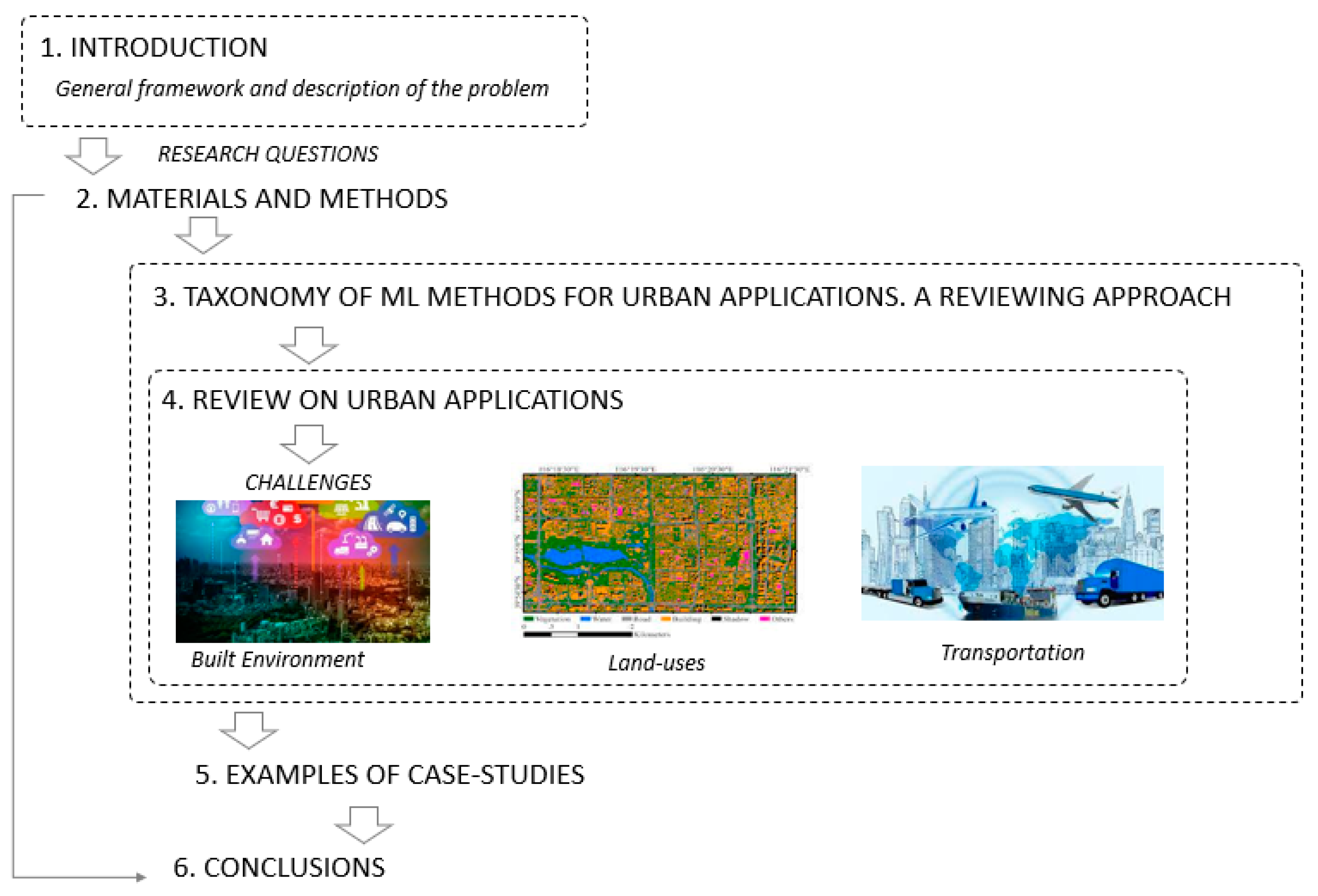
:1. Introduction
2. Materials and Methods
- The investigation of the spatial and temporal distribution of the selected sources with necessary filtering of the key information of title, authors, years and keywords and focusing mainly on English-language publications;
- The identification of sources by type of data provided (e.g., open or not);
- The chronological constraint from 2000 onwards;
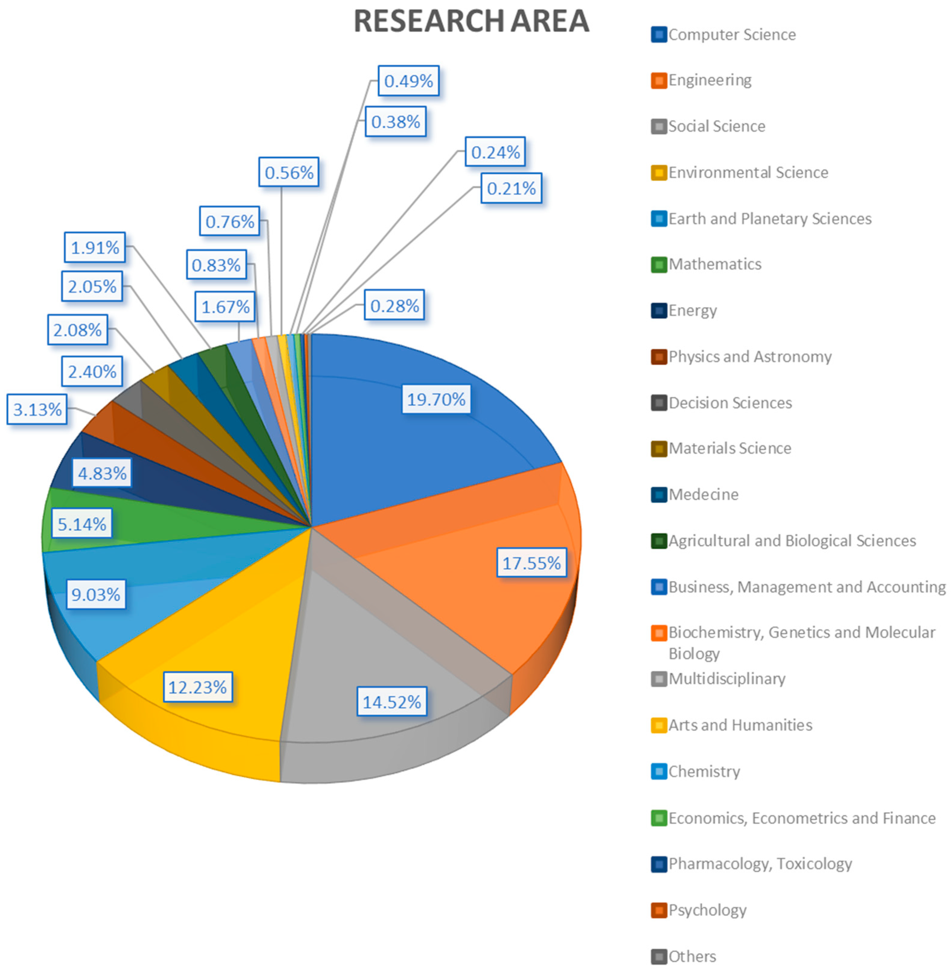
- The identification of specific keywords and research areas (computer science, engineering, environmental and among others) (Figure 2).
3. Taxonomy of ML Methods for Urban Applications
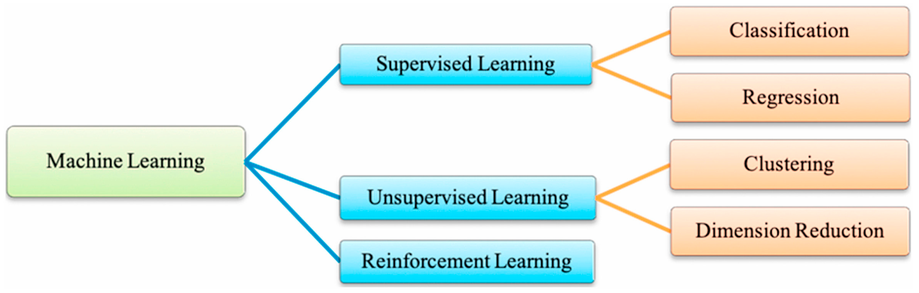
3.1. Supervised Learning
3.2. Unsupervised Learning
3.3. Machine Learning Algorithms: An Overview
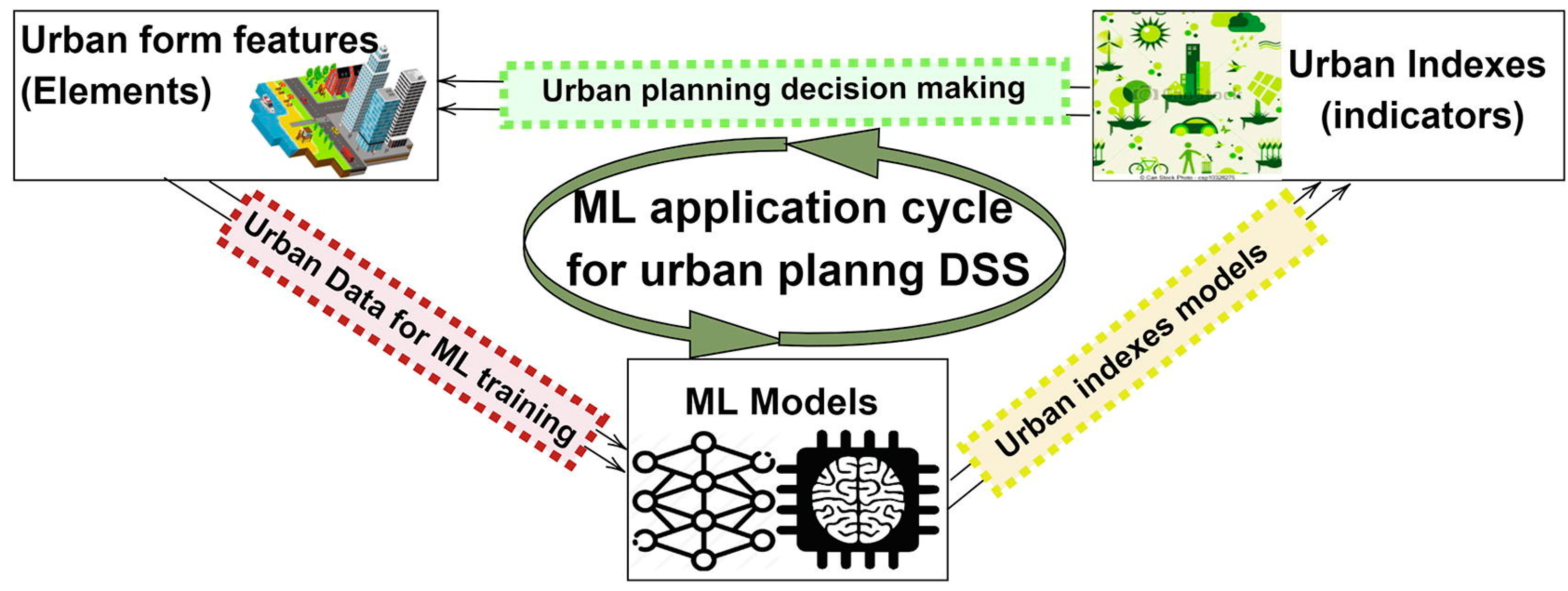
3.4. Decision-Making Urban Planning Processes
4. Review on Urban Applications
4.1. Machine Learning and Built Environment
- Forecasting energy consumption to reveal trends and predict future energy uses and assist energy planning, management or conservation to reduce the energy demand and the CO2 emissions [57] and alternative evaluations for an optimized operation to improve demand and supply balances [58]. Nonetheless, the demand for data collection (especially via intelligent sensors/meters) is evident. To that point, Ahmad et al. [59] underline the evolution of energy metering in technological terms, while Chammas et al. [60] analyze the importance of wireless networks and IoT-based methods for energy monitoring and relevant solutions. The literature unveils a significant number of studies related to forecasting activities and prediction performances; for example, Zhaond Liu [61] with respect to a highly-accurate prediction model for the building energy load with dynamic simulations;
- Detection and prediction of faults, in which traditional models do not provide preemptive interventions;
- Seasonality modeling, i.e., correlating themes to seasonal conditions.
4.2. Machine Learning and Land Use
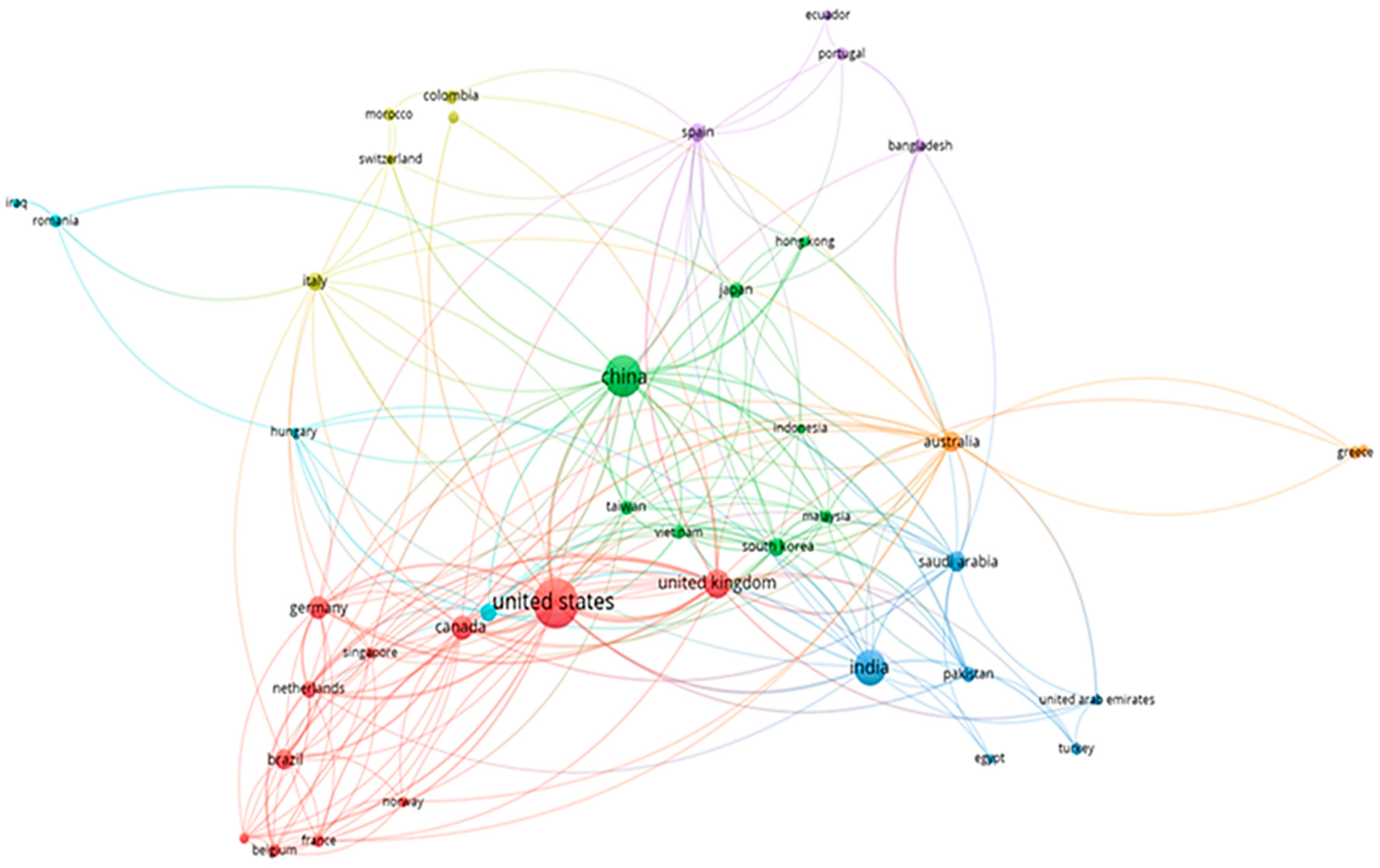
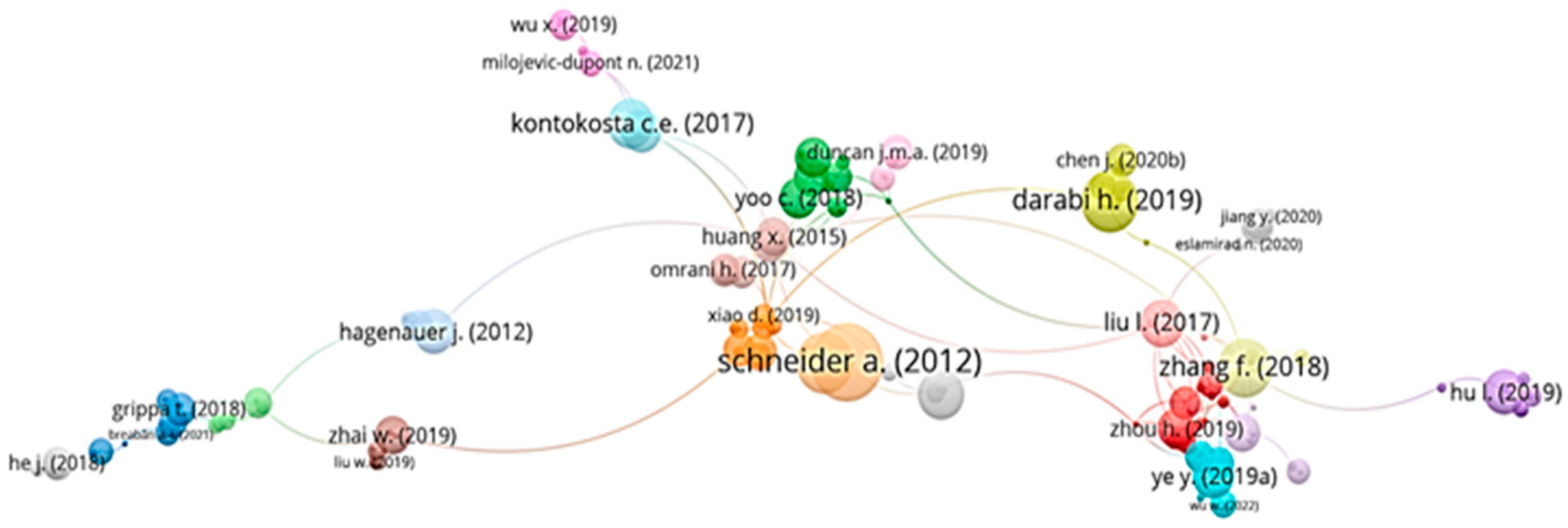
- An overview of the correlations of the existing works and studies of ML and urban fields to identify the authors’ names per year (1.372 documents) (Figure 9).
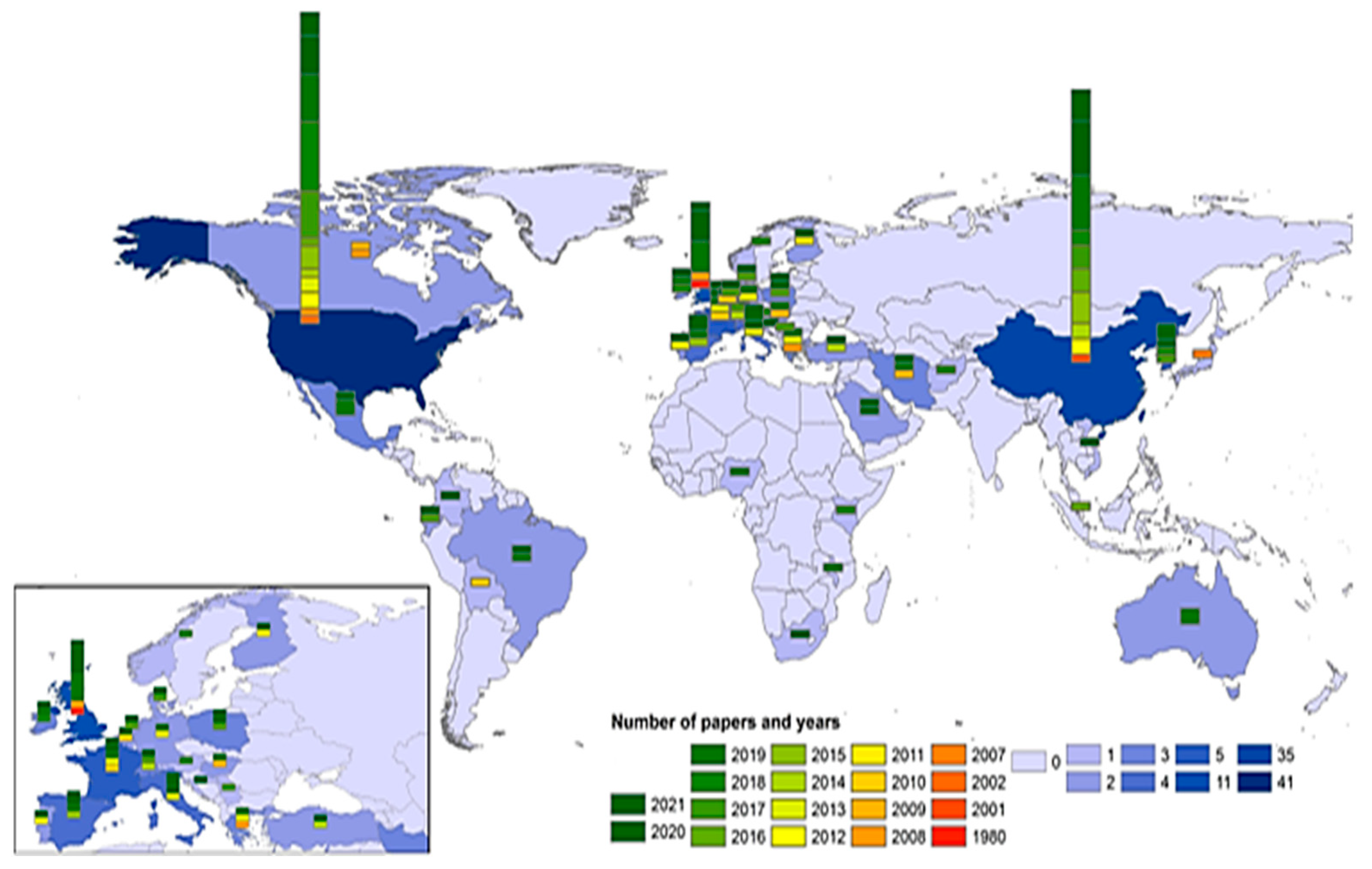
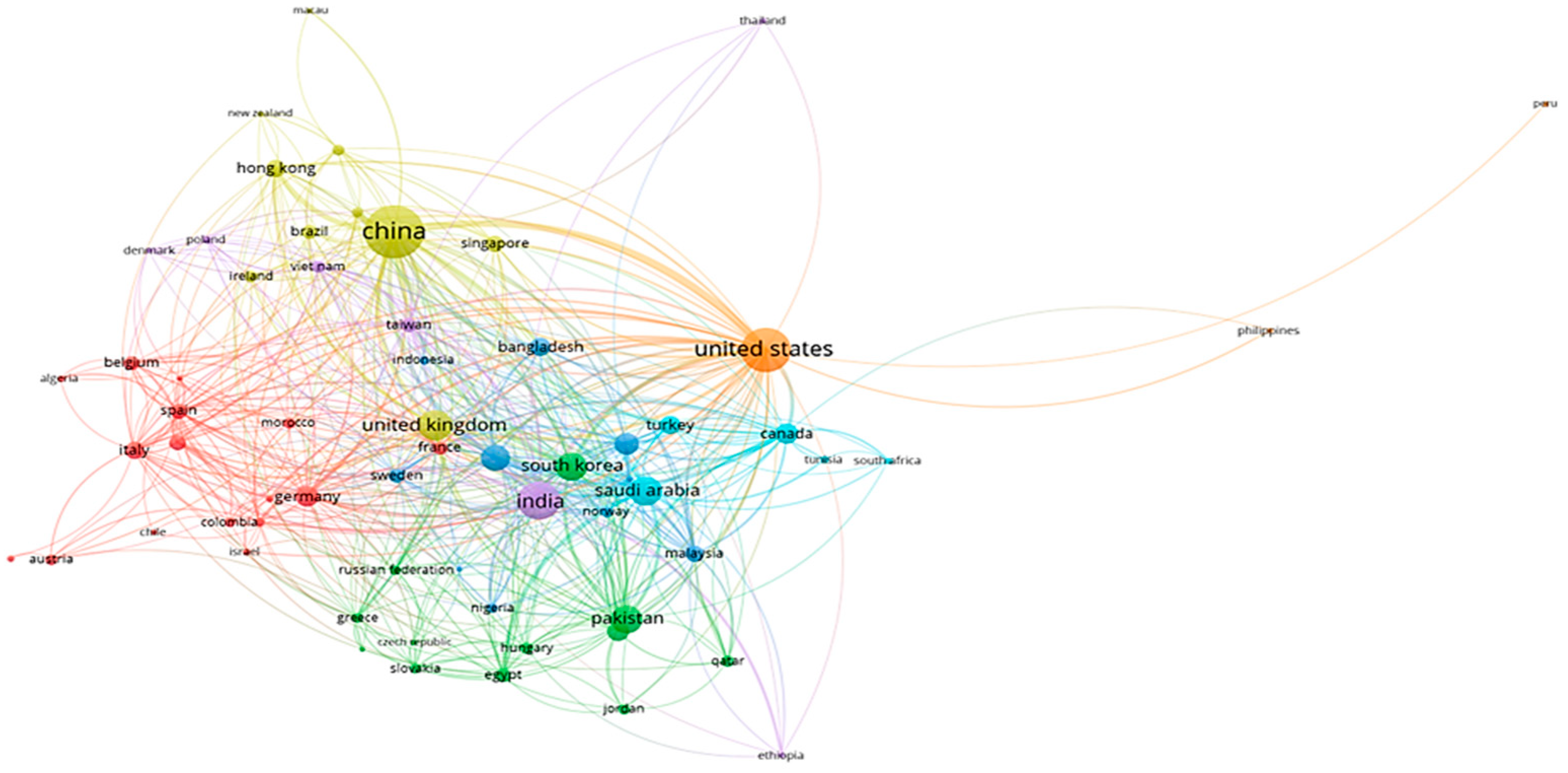
- An overview of the correlations of the existing works and studies of ML and urban fields to identify the number of citations per country (1.372 documents) (Figure 10).
5. Examples of Case-Studies
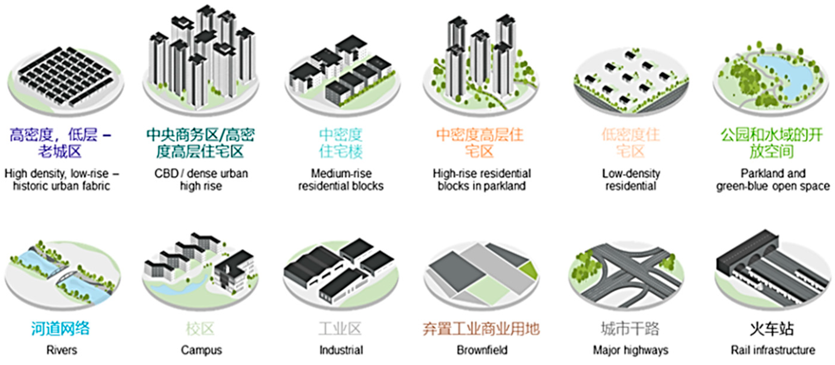
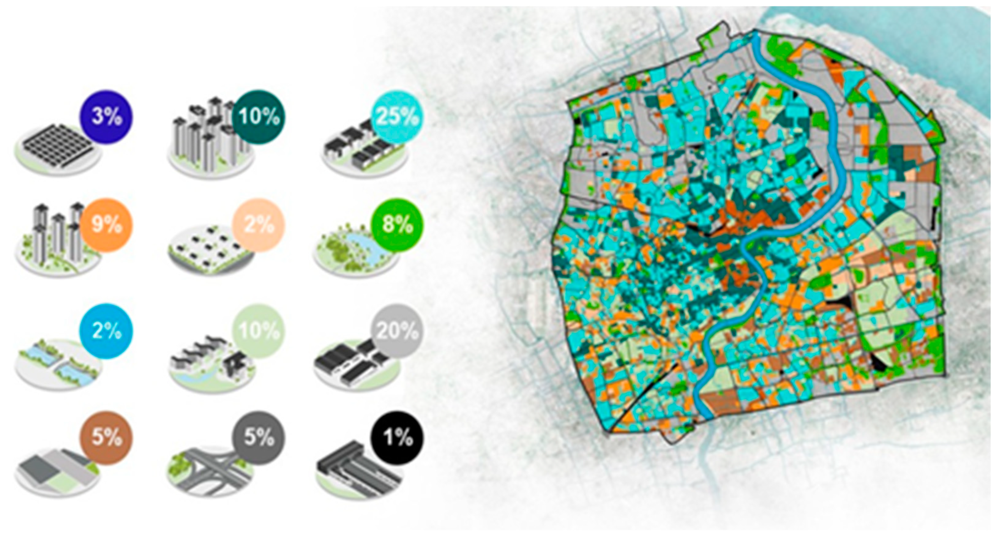
5.1. Shanghai Urban Drainage Masterplanning
- Integrated: considering the existing strategies in line with the ‘Sponge City’ and four elements: (a) a critical overarching system of governance mechanisms for collaboration and synergies; (b) green spaces to promote nature-based solutions (NBS); (c) blue equipment for flood defenses and relevant infrastructure; and (d) ‘grey’ equipment for drainage treatment (e.g., pumps, etc.);
- Adaptive: development of flexible approaches for risk management and uncertainties;
- Smart: integration of intelligent and digitalized models for optimization and data treatment of sophisticated scenarios based on planning strategies alongside the stormwater conditions.
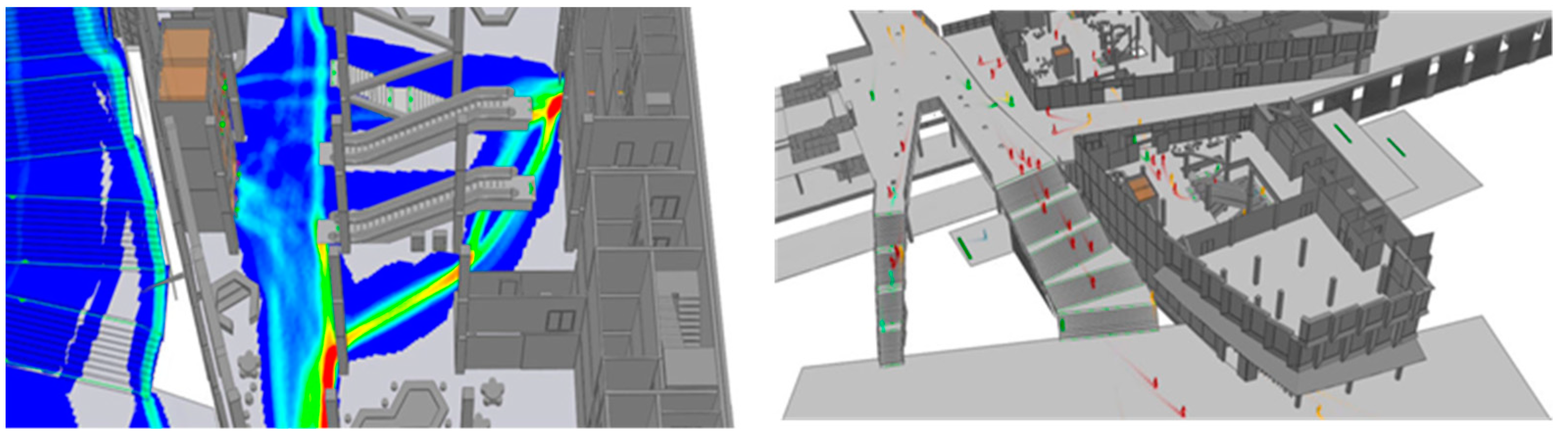
5.2. MassMotion Pedestrian Simulation
6. Conclusions
Author Contributions
Funding
Institutional Review Board Statement
Informed Consent Statement
Data Availability Statement
Conflicts of Interest
References
- Jordan, M.I.; Mitchell, T.M. Machine Learning: Trends. perspectives and prospects. Science 2015, 349, 255–260. [Google Scholar] [PubMed]
- Al-Garadi, M.A.; Mohamed, A.; Al-Ali, A.K.; Du, X.; Guizani, M. A survey of machine and deep learning methods for Internet of Things security. IEEE Commun. Surv. Tutor. 2020, 22, 1646–1685. [Google Scholar] [CrossRef] [Green Version]
- Bhavsar, P.; Safro, I.; Bouaynaya, N.; Polikar, R.; Dera, D. Machine Learning in Transportation Data Analytics. In Data Analytics for Intelligent Transportation Systems; Elsevier: Amsterdam, The Netherlands, 2017; pp. 283–306. [Google Scholar]
- Ross, T. The synthesis of intelligence-its implications. Psychol. Rev. 1938, 45, 185. [Google Scholar] [CrossRef]
- Choung, Y.J.; Kim, J.M. Study of the relationship between urban expansion and PM10 concentration using multi-temporal spatial datasets and the machine learning technique: Case study fo Daegu. South Korea. Appl. Sci. 2019, 9, 1098. [Google Scholar] [CrossRef] [Green Version]
- Fecht, D.; Beale, L.; Briggs, D. A GIS-based urban simulation model for environmental health analysis. Environ. Model. Softw. 2014, 58, 1–11. [Google Scholar] [CrossRef]
- Samuel, A.L. Some studies in Machine Learning using the game of checkers. IBM J. Res. Dev. 1959, 3, 210–229. [Google Scholar] [CrossRef]
- Li, X.; Cheng, S.; Lv, Z.; Song, H.; Jia, T.; Lu, N. Data analytics of urban fabric metrics for smart cities. Futur. Gener. Comput. Syst. 2020, 107, 871–882. [Google Scholar] [CrossRef]
- Schwab, K. The Fourth Industrial Revolution, 1st ed. 2016. Available online: https://law.unimelb.edu.au/__data/assets/pdf_file/0005/3385454/Schwab-The_Fourth_Industrial_Revolution_Klaus_S.pdf (accessed on 12 November 2022).
- Chaturvedi, V.; De Vries, W. Machine Learning Algorithms for Urban Land Use Planning. A review. Urban Sci. 2021, 5, 68. [Google Scholar] [CrossRef]
- Shaikh Hameed, P.; Mohd Nor, N.; Nallagownden, P.; Elamvazuthi, I.; Ibrahim, T. A review on optimized control systems for building energy and comfort management of smart sustainable buildings. Renew. Sustain. Energy Rev. 2014, 34, 409–429. [Google Scholar] [CrossRef]
- Neri, E.; Coppola, F.; Miele, V.; Bibbolino, C.; Grassi, R. Artificial Intelligence: Who is responsible for the diagnosis? Radiol. Med. 2020, 125, 517–521. [Google Scholar] [CrossRef]
- Samardzic-Petrovic, M.; Kovacevic, M.; Bajat, B.; Dragicevic, S. Machine learning techniques for modelling short term land-use change. ISPRS Int. J. Geo-Inf. 2017, 6, 387.Batty, M. Big data and the city. Built Environ. 2016, 42, 321–337. [Google Scholar]
- Hagenauer, J.; Omrani, H.; Helbich, M. Assessing the performance of 38 Machine Learning models: The case of land consumption rates in Bavaria. Germany. Int. J. Geogr. Inf. Sci. 2019, 33, 1399–1419. [Google Scholar] [CrossRef] [Green Version]
- Robert, C. Machine Learning, a Probabilistic Perspective. Chance 2014, 27, 62–63. [Google Scholar] [CrossRef]
- Gomez, J.A.; Patino, J.E.; Duque, J.C.; Passos, S. Spatiotemporal modeling of urban growth using machine learning. Remote Sens. 2020, 12, 109. [Google Scholar] [CrossRef] [Green Version]
- Lim, T.S.; Loh, W.Y.; Shih, Y.S. A comparison of prediction accuracy. complexity. and training time of thirty-three old and new classification algorithms. Mach. Learn. 2000, 40, 203–228. [Google Scholar] [CrossRef]
- Casali, Y.; Yonca Aydin, N.; Comes, T. Machine learning for spatial analyses in urban areas: A scoping review. Sustain. Cities Soc. 2022, 85, 104050. [Google Scholar]
- Guigoz, Y.; Giuliani, G.; Nonguierma, A.; Lehmann, A.; Mlisa, A.; Ray, N. Spatial data infrastructures in Africa: A gap analysis. J. Environ. Inform. 2017, 30, 53–62. [Google Scholar] [CrossRef]
- Leyk, S.; Gaughan, A.E.; Adamo, S.B.; Sherbinin, A.; Deborah, B.; Sergio, F.; Amy, R.; Stevens, F.R.; Brian, B.; Charlie, F. The spatial allocation of population: A review of large-scale gridded population data products and their fitness for use. Earth Syst. Sci. Data 2019, 11, 1385–1409. [Google Scholar] [CrossRef] [Green Version]
- Varshney, H.; Khna, R.A.; Khan, U.; Verma, R. Approaches of Artificial Intelligence and Machine Learning in Smart Cities: A critical review. IOP Conf. Ser. Mater. Sci. Eng. 2021, 1022, 012019. [Google Scholar] [CrossRef]
- Gao, J.; O’Neill, B.C. Data-driven spatial modeling of global long-term urban land development: The select model. Environ. Model. Softw. 2019, 119, 458–471. [Google Scholar] [CrossRef]
- Murphy, K. Machine Learning: A Probabilistic Perspective. 2012. Available online: http://noiselab.ucsd.edu/ECE228/Murphy_Machine_Learning.pdf (accessed on 12 November 2022).
- Fathi, S.; Srinivasan, R.; Fenner, A.; Fathi, S. Machine learning applications in urban building energy performance forecasting: A systematic review. Renew. Sustain. Energy Rev. 2020, 133, 110287. [Google Scholar] [CrossRef]
- Chen, Z.; Deng, L.; Luo, Y.; Li, D.; Marcato, J.; Gonçalves, W.N.; Nurunnabi, A.; Li, J.; Wang, C.; Li, D. Road extraction in remote sensing data: A survey. Int. J. Appl. Earth Obs. Geoinf. 2022, 112, 102833. [Google Scholar] [CrossRef]
- Poullis, C.; You, S. Delineation and geometric modeling of road networks. ISPRS J. Photogramm. Remote Sens. 2010, 65, 165–181. [Google Scholar] [CrossRef]
- Wegner, J.D.; Montoya-Zegarra, J.A.; Schindler, K. Road networks as collections of minimum cost paths. ISPRS J. Photogramm. Remote Sens. 2015, 108, 128–137. [Google Scholar] [CrossRef]
- Lu, P.; Du, K.; Yu, W.; Wang, R.; Deng, Y.; Balz, T. A new region growing-based method for road network extraction and its application on different resolution SAR images. IEEE J. Sel. Top. Appl. Earth Obs. Remote Sens. 2014, 7, 4772–4783. [Google Scholar] [CrossRef]
- Perciano, T.; Tupin, F.; Hirata, R.; Cesar, R.M. A two-level markov random field for road network extraction and its application with optical. Sar and multitemporal data. Int. J. Remote Sens. 2016, 37, 3584–3610. [Google Scholar] [CrossRef]
- Khesali, E.; Zoej Valadan, M.J.; Mokhtarzade, M.; Dehghani, M. Semi automatic road extraction by fusion of high resolution optical and radar images. J. Indian Soc. Remote Sens. 2016, 44, 21–29. [Google Scholar] [CrossRef]
- Jochem, W.C.; Bird, T.J.; Tatem, A.J. Identifying residential neighbourhood types from settlement points in a machine learning approach. Comput. Environ. Urban Syst. 2018, 69, 104–113. [Google Scholar] [CrossRef]
- Ma, J.; Cheng, J.C.; Jiang, F.; Chen, W.; Zhang, J. Analyzing driving factors of land values in urban scale based on big data and non-linear machine learning techniques. Land Use Policy 2020, 94, 104537. [Google Scholar] [CrossRef]
- Novack, T.; Esch, T.; Kux, H.; Stilla, U. Machine learning comparison between worldview-2 and quickbird-2-simulated imagery regarding object-based urban land cover classification. Remote Sens. 2011, 3, 2263–2282. [Google Scholar] [CrossRef] [Green Version]
- Shafizadeh-Moghadam, H.; Asghari, A.; Tayyebi, A.; Taleai, M. Coupling machine learning. tree-base and statistical models with cellular automata to simulate urban growth. Comput. Environ. Urban Syst. 2017, 64, 297–308. [Google Scholar] [CrossRef]
- Koumetio Tekouabou, S.C.; Diop, E.B.; Azmi, R.; Jaligot, R.; Chenal, J. Reviewing the application of machine learning methods to model urban form indicators in planning decision support systems: Potential. issues and challenges. J. King Saud Univ. Inf. Sci. 2022, 22, 5943–5967. [Google Scholar] [CrossRef]
- Hernandez Ruiz, I.E.; Shi, W.A. Random forests classification method for urban land-use mapping integrating spatial metrics and texture analysis. Int. J. Remote Sens. 2018, 39, 1175–1198. [Google Scholar] [CrossRef]
- Wubie, A.M.; De Vries, W.T.; Alemie, B.K. A socio-spatial analysis of land-use dynamics and process of land intervention in the peri-urban areas of Bahir Dar City. Land 2020, 9, 445. [Google Scholar] [CrossRef]
- Wu, E.; Silva, N. Artificial Intelligence solutions for urban land dynamics: A review. J. Plan. Lit. 2010, 24, 246–265. [Google Scholar]
- Abdulijabbar, R.; Dia, H.; Liyanage, S.; Bagloee, S.A. Applications of Artificial Intelligence in transport: An overview. Sustainability 2019, 11, 189. [Google Scholar] [CrossRef] [Green Version]
- Yigitcanlar, T.; Kankanamge, N.; Velia, K. How are smart city concepts and technologies perceived and utilized? A systematic Geo-Twitter analysis of smart cities in Australia. J. Urban Technol. 2021, 28, 135–154. [Google Scholar] [CrossRef]
- Kamrowska-Zaluska, D. Impact of AI-based tool and urban big data analytics on the design and planning of cities. Land 2021, 10, 1209. [Google Scholar] [CrossRef]
- Patel, A.; Crooks, A.; Koizumi, N. Spatial Agent-Based Modeling to Explore Slum Formation Dynamics in Ahmedabad, India. In GeoComputational Analysis and Modeling of Regional Systems; Springer: Berlin/Heidelberg, Germany, 2018; pp. 121–141. [Google Scholar]
- Patt, T.R. Multiagent approach to temporal and punctual urban development in dynamic, informal contexts. Int. J. Archit. Comput. 2018, 16, 199–211. [Google Scholar]
- Grekoussis, G.; Manetos, P.; Photis, Y.N. Modeling urban evolution using neural networks, fuzzy logic and GIS: The case of the Athens metropolitan area. Cities 2013, 30, 193–203. [Google Scholar] [CrossRef]
- Hwang, S.; Lee, Z.; Kim, J. Real-time pedestrian flow analysis unsing networked sensors for a smart subway system. Sustainability 2019, 11, 6560. [Google Scholar] [CrossRef] [Green Version]
- Ibrahim, M.R.; Haworth, J.; Cheng, T. URBAN-i: From urban scenes to mapping slums. transport modes and pedestrians in cities using deep learning and computer vision. Environ. Plan. B Urban Anal. City Sci. 2019, 48, 76–93. [Google Scholar] [CrossRef] [Green Version]
- Soltani, A.; Karimzadeh, D. The spatiotemporal modeling of urban growth case study: Mahabad, Iran. TeMA J. Land Use Mobil. Environ. 2013, 6, 189–200. [Google Scholar]
- Hao, J.; Zhu, J.; Zhong, R. The rise of Big Data on urban studies and planning practices in China: Review and open research issues. J. Urban Manag. 2015, 4, 92–124. [Google Scholar] [CrossRef] [Green Version]
- Byon, Y.J.; Liang, S. Real-time transportation mode detection using smartphones and Artificial Neural Networks: Performance Comparisons between smartphones and conventional global positioning system sensors. J. Intell. Transp. Syst. Technol. Plan. Oper. 2014, 18, 264–272. [Google Scholar] [CrossRef]
- Cheng, X.M.; Wang, J.Y.; Li, H.F.; Zhang, Y.; Wu, L.; Liu, Y. A method to evaluate task-specific importance of spatiotemporal units based on explainable artificial intelligence. Int. J. Geogr. Inf. Sci. 2020, 35, 2002–2025. [Google Scholar] [CrossRef]
- Huang, J.; Obracht-Prondzynska, H.; Kamrowska-Zaluska, D. The image of the city on social media: A comparative study using ‘Big Data’ and ‘Small Data’ methods in the Tri-city region in Poland. Landsc. Urban Plan. 2021, 20, 103977. [Google Scholar] [CrossRef]
- Quand, S.J.; Park, J.; Economou, A.; Lee, S. Artificial intelligence-aided design: Smart design for sustainable city development. Environ. Plan. B 2019, 46, 1581–1599. [Google Scholar]
- Wang, W.J.; Wang, W.; Namgung, M. Linking people’s perceptions and physical components of sidewalk environments-an application of rough sets theory. Environ. Plan. B 2010, 37, 234–247. [Google Scholar] [CrossRef]
- Kwok, S.S.K.; Lee, E.W.M. A study of the importance of occupancy to building cooling load in prediction by intelligent approach. Energy Convers. Manag. 2011, 52, 2555–2564. [Google Scholar] [CrossRef]
- Wenbin Tien, P.; Wei, S.; Darkwa, J.; Wood, C.; Calautit, J. Machine Learning and Deep Learning Methods for Enhancing Building Energy Efficiency and Indoor Environmental Quality—A Review. Energy AI 2022, 10, 100198. [Google Scholar] [CrossRef]
- Schoenfeld, J. Using Machine Learning to Improve Building Energy Efficiency. 2022. Available online: https://www.buildingsiot.com/blog/using-machine-learning-to-improve-building-energy-efficiency-bd (accessed on 30 November 2022).
- Amasyali, K.; El-Gohary, N.M. A review of data-driven building energy consumption prediction studies. Renew. Sustain. Energy Rev. 2018, 81, 1192–1205. [Google Scholar] [CrossRef]
- Fan, C.; Wang, J.; Gang, W.; Li, S. Assessment of deep recurrent neural network-based strategies for short-term building energy predictions. Appl. Energy 2019, 236, 700–710. [Google Scholar] [CrossRef]
- Ahmad, M.W.; Mourshed, M.; Mundow, D.; Sisinni, M.; Rezgui, Y. Building energy metering and environmental monitoring-A state of the art review and directions for future research. Energy Build. 2016, 120, 85–102. [Google Scholar] [CrossRef] [Green Version]
- Chammas, M.; Makhoul, A.; Demerjian, J. An efficient data model for energy prediction using wireless sensors. Comput. Electr. Eng. 2019, 76, 249–257. [Google Scholar] [CrossRef] [Green Version]
- Zhao, J.; Liu, X. A hybrid method of dynamic cooling and heating load forecasting for office buildings based on Artificial Intelligence and regression analysis. Energy Build. 2018, 174, 293–308. [Google Scholar] [CrossRef]
- Cheng, C.C.; Lee, D. Artificial Intelligence-Assisted Heating Ventilation and Air Conditioning Control and the Unmet Demand for Sensors: Part I. Problem Forumation and the Hypothesis. Sensors 2019, 19, 1131. [Google Scholar] [CrossRef] [Green Version]
- Ngaramble, J.; Yun, G.Y.; Santamouris, M. The use of Artificial Intelligence (AI) methods in the prediction of thermal comfort in buildings: Energy implications of AI-based thermal comfort controls. Energy Build. 2020, 211, 109807. [Google Scholar] [CrossRef]
- Iddianozie, C.; Palmes, P. Towards smart sustainable cities: Addressing semantic heterogeneity in Building Management Systems using discriminative models. Sustain. Cities Soc. 2020, 162, 102367. [Google Scholar] [CrossRef]
- Alanne, K.; Sierla, S. An overview of machine learning applications for smart buildings. Sustain. Cities Soc. 2022, 76, 103445. [Google Scholar] [CrossRef]
- RICS. Artificial Intelligence: What It Means for the Built Environment? 2017. Available online: https://www.rics.org/uk/news-insight/research/insights/artificial-intelligence-what-it-means-for-the-built-environment/ (accessed on 27 November 2022).
- Sacks, R.; Girolami, M.; Brilakis, I. Building Information Modelling, Artificial Intelligence and Construction Tech. Dev. Built Environ. 2020, 4, 100011. [Google Scholar] [CrossRef]
- Gholizadeh, P.; Esmaeili, P.; Goorum, B. Diffusion of Building Information Modeling functions in the construction industy. J. Manag. Eng. 2018, 34, 04017060. [Google Scholar] [CrossRef]
- Maher, M.L.; Fenves, S.J. HI-RISE—An Expert System for the Preliminary Structural Design of High Rise Buildings. In Knowledge Engineering in Computer-Aided Design; North-Holland: Amsterdam, The Netherlands, 1985. [Google Scholar]
- Garrett, J.; Fenves, S.J. A knowledge-based standards processor for structural component design. Eng. Comput. 1987, 2, 219–238. [Google Scholar] [CrossRef]
- Sacks, R.; Buyukozturk, O. Expert interactive design of R/C columns under biaxial bending. J. Comput. Civ. Eng. 1987, 1, 69–81. [Google Scholar] [CrossRef]
- Al Qady, M.; Kandil, A. Concept relation extraction from construction documents using natural language processing. J. Constr. Eng. Manag. 2010, 136, 294–302. [Google Scholar] [CrossRef]
- Brilakis, I.; Soibelman, L.; Shinagawa, Y. Material-based construction site image retrieval. J. Comput. Civ. Eng. 2005, 19, 341–355. [Google Scholar] [CrossRef]
- Ballard, G. The Lean Project Delivery System: An update. Lean Constr. J. 2008, 1–19. [Google Scholar]
- Liu, M.; Hu, Y.M.; Li, C.L. Landscape metrics for three-dimensional urban building pattern recognition. Appl. Geogr. 2017, 87, 66–72. [Google Scholar] [CrossRef]
- Suveg, I.; Vosselman, G. Automatic 3D building reconstruction. Three-Dimens. Image Capture Appl. V 2002, 4661, 59–69. [Google Scholar]
- Alexander, C.; Smith-Voysey, S.; Jarvis, C.; Tansey, K. Integrating building footprints and LIDAR elevation data to classify roof structures and visualize buildings. Comput. Environ. Urban Syst. 2009, 33, 285–292. [Google Scholar] [CrossRef]
- Awrangjeb, M.; Ravanbakhsh, M.; Fraser, C.S. Automatic detection of residential buildings using LIDAR and multispectral imagery. ISPRS. J. Photogramm. Remote Sens. 2010, 65, 457–467. [Google Scholar] [CrossRef] [Green Version]
- Khosravi, I.; Momeni, M.; Rahnemoonfar, M. Performance evaluation of object-based and pixel-based building detection algorithms from very high spatial resolution imagery. Photogramm. Eng. Remote Sens. 2014, 80, 519–528. [Google Scholar] [CrossRef] [Green Version]
- Mohan, R.; Nevatia, R. Using perceptual organization to extract 3-D structures. IEEE Trans. Pattern Anal. Mach. Intell. 1989, 11, 1121–1139. [Google Scholar] [CrossRef]
- Weidner, U. Digital Surface Models for Building Extraction. In Automatic Extraction of Man-Made Objects from Aerial and Space Images; Springer: Berlin/Heidelberg, Germany, 1997. [Google Scholar]
- Hashem, N.; Balakrishnan, P. Change analysis of land use/land cover and modelling urban growth in greated Doha, Qatar. Ann. GIS 2014, 21, 233–247. [Google Scholar] [CrossRef] [Green Version]
- Heistermann, M.; Muller, C.; Ronneberger, K. Land in sight? Achievements, deficits and potentials of continental to global scale land-use modeling. Agric. Ecosyst. Environ. 2006, 114, 141–158. [Google Scholar] [CrossRef]
- Kline, J.D.; Moses, A.; Lettman, G.J.; Azuma, D.L. Modeling forest and range land development in rural locations: With examples from Eastern Oregon. Landsc. Urban Plan. 2007, 80, 320–332. [Google Scholar] [CrossRef]
- Schulp, C.J.; Naburrs, G.; Verburg, P.H. Future carbon sequestration in Europe-effects of land use change. Agric. Ecosyst. Environ. 2008, 127, 251–264. [Google Scholar] [CrossRef]
- Clarke, K.C.; Gaydos, L.J. Loose-coupling a cellular automation model and GIS: Long-term urban growth prediction for San Francisco and Washington/Baltimore. Int. J. Geogr. Inf. Sci. 1998, 12, 699–714. [Google Scholar] [CrossRef]
- Xia, C.; Gar-On Yeh, A.; Zhang, A. Analyzing spatial relationships between urban land use intensity and urban vitality at street block level: A case study of five Chinese megacities. Landsc. Urban Plan. 2020, 193, 103669. [Google Scholar] [CrossRef]
- Liu, H.; Chen, H.; Hong, R.; Liu, H.; You, W. Mapping knowledge structure and research trends of emergency evacuation studies. Saf. Sci. 2020, 121, 348–361. [Google Scholar] [CrossRef]
- White, R.; Engelen, G.; Ulijee, I. The use of constrained cellular automata for high-resolution modelling of urban land-use dynamics. Environ. Plan. B Plan. Des. 1997, 24, 323–343. [Google Scholar] [CrossRef]
- Batty, M.; Couclelis, H.; Eichen, M. Urban systems as cellular automata. Environ. Plan. B Plan. Des. 1997, 24, 159–164. [Google Scholar] [CrossRef]
- Liu, X.; Liang, X.; Li, X.; Xu, X.; Ou, J.; Chen, Y.; Li, S.; Wang, S.; Pei, F. A Future Land-Use model (FLUS) for simulating multiple land use scenarios by coupling human and natural effects. Landsc. Urban Plan. 2017, 168, 94–116. [Google Scholar] [CrossRef]
- Rogan, J.; Franklin, J.; Stow, D.; Miller, J.; Woodcock, C.; Roberts, D. Mapping land-cover modifications over large areas: A comparison of machine learning algorithms. Remote Sens. Environ. 2008, 112, 2272–2283. [Google Scholar] [CrossRef]
- Heung, B.; Chak Ho, H.; Zhang, J.; Knudgy, A.; Bulmer, C. An overview and comparison of machine learning techniques for classification purposes in digital soil mapping. Geoderma 2016, 265, 62–77. [Google Scholar] [CrossRef]
- Omrani, H.; Parmentier, B.; Helbich, M.; Pijanowski, B. The land transformation model-cluster framework: Applying k-means and the Spark computing environment for large scale land change analytics. Environ. Model. Softw. 2019, 111, 182–191. [Google Scholar] [CrossRef]
- Du, G.; Shin, K.J. A comparative approach to modelling multiple urban land use changes using tree-based methods and cellular automata: The case of Greater Tokyo Area. Int. J. Geogr. Inf. Sci. 2018, 32, 757–782. [Google Scholar] [CrossRef]
- Hagenauer, J.; Helbich, M. Local modelling of land consumption in Germany with RegioClust. Int. J. Appl. Earth Obs. Geoinf. 2018, 65, 46–56. [Google Scholar] [CrossRef]
- Veldkamp, A.; Lambin, E.F. Predicting land-use change. Agric. Ecosyst. Environ. 2001, 85, 1–6. [Google Scholar] [CrossRef]
- Tayyebi, A.; Pijanowski, B.C. Modeling multiple land use changes using ANN. CART and MARS: Comparing tradeoffs in goodness of fit and explanatory power of data mining tools. Int. J. Appl. Earth Obs. Geoinf. 2014, 28, 102–116. [Google Scholar] [CrossRef]
- Rienow, A.; Goetzke, R. Supporting SLEUTH-Enhancing a cellular automation with support vector machines for urban growth modeling. Comput. Environ. Urban Syst. 2015, 49, 66–81. [Google Scholar] [CrossRef]
- Brown, D.; Verburg, P.H.; Pontius, R.; Lange, M.D. Opportunities to improve impact. integration and evaluation of land change models. Curr. Opin. Environ. Sustain. 2013, 5, 452–457. [Google Scholar] [CrossRef]
- Song, J.; Kim, J.; Lee, J.K. NLP and deep learning-based analysis of building regulations to support automated rule checking system. In Proceedings of the 35th International Symposium on Automation and Robotics in Construction (ISARC); IAARC Publications: Waterloo, ON, Canada, 2018. [Google Scholar]
- Zhang, J.; El-Gohary, N. Integrating semantic NLP and logic reasoning into a unified system for fully-automated code checking. Autom. Constr. 2017, 73, 45–57. [Google Scholar] [CrossRef] [Green Version]
- Witten, H.; Frank, E. Data Mining: Practical Machine Learning tools and techniques with java implementations. ACM SIGMOD Rec. 2002, 31, 76–77. [Google Scholar] [CrossRef]
- Nagappan, S.D.; Mohd Daud, S. Machine Learning Predictors for Sustainable Urban Planning. Int. J. Adv. Comput. Sci. Appl. 2021, 12, 1–9. [Google Scholar] [CrossRef]
- Shafizadeh-Moghadam, H.; Helbich, M. Spatiotemporal variability of urban growth factors: A global and local perspective on the megacity of Mumbai. Int. J. Appl. Earth Obs. Geoinf. 2015, 35, 187–198. [Google Scholar] [CrossRef]
- Karimi, F.; Sultana, S.; Babakan Shirzadi, A.; Suthaharan, S. An enhanced support vector machine model for urban expansion prediction. Comput. Environ. Urban Syst. 2019, 75, 61–75. [Google Scholar] [CrossRef]
- Mohamed, M.; Anders, A.; Schneider, C. Monitoring of changes in land use/land cover in Syria from 2010 to 2018 using multitemporal landsat imagery and GIS. Land 2020, 9, 226. [Google Scholar] [CrossRef]
- Karakus, C.B. The impact of land use/land cover changes on land surface temperature in Sivas city center and its surroundings andd assessment of Urban Heat Island. Asia Pacific Dev. J. Atmos. Sci. 2019, 55, 69–684. [Google Scholar]
- Deep, S.; Saklani, A. Urban sprawl modeling using cellular automata. Egypt. J. Remote Sens. Sp. Sci. 2014, 17, 179–187. [Google Scholar] [CrossRef] [Green Version]
- Vaz, E.N.; Nijkamp, P.; Painho, M.; Caetano, M. A multi-scenario forecast of urban change: A study on urban growth in the algarve. Landsc. Urban Plan. 2012, 104, 201–211. [Google Scholar] [CrossRef] [Green Version]
- Musa, S.I.; Hashim, M.; Reba, M.N.M. A review of geospatial-based urban growth models and modelling initiatives. Geocarto Int. 2016, 32, 813–833. [Google Scholar] [CrossRef]
- Alsharif, A.A.A.; Pradhan, B. Urban sprawl analyis of Tripoli metropolitan city (Libya) using remote sensing data and mutlivariate logistic regression models. J. Indian Soc. Remote Sens. 2013, 42, 149–163. [Google Scholar] [CrossRef]
- Tripathy, P.; Bandopadhyay, A.; Raman, R.; Singh, S.K. Urban growth modeling using logistic regression and geo-informatics: A case of Jaipur. India. Int. J. Sci. Technol. 2018, 13, 47–62. [Google Scholar]
- Motieyan, H.; Mesgari, M.S. An agent-based modeling approach for sustainable urban planning from land use and public transit perspectives. Cities 2018, 81, 91–100. [Google Scholar] [CrossRef]
- Shirzadi Babakan, A.; Taleai, M. Impacts of transport development on residence choice of renter households: An agent-based evaluation. Habitat Int. 2015, 49, 275–285. [Google Scholar] [CrossRef] [Green Version]
- Zhang, Q.; Vatsavai, R.R.; Shashidharan, A.; Van Berkel, D. Agent-based urban growth modeling framework on apache spark. In Proceedings of the 5th ACM SIGSPATIAL Internationl Workshop on Analytics for Big Geospatial Data, BigSpatial; Association for Computing Machinery: New York, NY, USA, 2016. [Google Scholar]
- Jin, H.; Mountrakis, G. Integration of urban growth modelling products with image-based urban change analysis. Int. J. Remote Sens. 2013, 66, 127–137. [Google Scholar] [CrossRef]
- Samardzic-Petrovic, M.; Dragicevic, S.; Kovacevic, M.; Bajat, B. Modeling urban land use changes using support vector machines. Transcactions GIS 2016, 20, 718–734. [Google Scholar] [CrossRef]
- Deng, Y.; Srinivasan, S. Urban land use change and regional access: A case study in Beijing. China. Habitat Int. 2016, 51, 103–113. [Google Scholar] [CrossRef]
- Samara, F.; Tampekis, S.; Sakellariou, S.; Christopoulou, O. Sustainable indicators for land use planning evaluation: The case of a small greek island. In Proceedings of the 4 th International Conference on Environmental Management, Engineering, Planning and Economics (CEMEPE), Mykonos, Greece, 24–28 June 2013. [Google Scholar]
- Rahmati, O.; Golkarian, A.; Biggs, T.; Keesstra, S.; Mohammadi, F.; Daliakopoulos, I.N. Land subsidence hazard modeling: Machine learning to identify predictors and the role of human activities. J. Environ. Manag. 2019, 236, 466–480. [Google Scholar] [CrossRef]
- Tarabon, S.; Bergès, L.; Dutoit, T.; Isselin-Nondedeu, F. Environmental impact assessment of development projects improved by merging species distribution and habitat connectivity modelling. J. Environ. Manag. 2019, 241, 439–449. [Google Scholar] [CrossRef] [PubMed] [Green Version]
- Lin, J.; Li, H.; He, X.; Zhuang, Y.; Liang, Y.; Lu, S. Estimating potential illegal and development in conservation areas based on a presence-only model. J. Environ. Manag. 2022, 321, 115994. [Google Scholar] [CrossRef] [PubMed]
- Li, W.; Guo, Q. A maximum entropy approach to one-class classification of remote sensing imagery. Int. J. Remote Sens. 2010, 31, 2227–2235. [Google Scholar] [CrossRef]
- Townsend Peterson, A.; Papes, M.; Eaton, M. Transferability and model evaluation in ecological niche modeling: A comparison of GARP and Maxent. Ecography 2007, 30, 550–560. [Google Scholar] [CrossRef]
- Cavendish, W. Artificial Intelligene and Machine Learning. Human Creativity Augmented by the Immense Power of Machines. 2022. Available online: https://www.arup.com/services/digital/artificial-intelligence-and-machine-learning (accessed on 24 November 2022).
- Sagris, T.; Zhao, M. Shanghai’s Urban Drainage Masterplan—A Vision for 2030. 2022. Available online: https://www.ciwem.org/the-environment/shanghai’s-urban-drainage-masterplan (accessed on 24 November 2022).
- Rivers, E.; Jaynes, C.; Kimball, A.; Morrow, E. Using case study data to validate 3D Agent-based pedestrian simulation tool for building egress modeling. Transp. Res. Procedia 2014, 2, 123–131. [Google Scholar] [CrossRef]
- Montjoy, V. Powerful Crowd Simulation Software for Human-Centered Design. 2022. Available online: https://www.archdaily.com/990775/powerful-crowd-simulation-software-for-human-centered-design (accessed on 30 November 2022).


| Urban Theme | Scope | AI-Based Tools | Reference(s) |
|---|---|---|---|
| Polycentricity | Flow analysis and linkages, spatial simulations | Artificial neural networks, fuzzy logic, agent-based models | e.g., [31,32] |
| Spatial structures and dynamic analyses | Study on the functional structures of the city, mobility configurations, land-use identification | Artificial neural networks, fuzzy logic, agent-based models | e.g., [33,34] |
| Flows’ analyses | Analysis of different types of flows in cities (e.g., energy, mobility, etc.) | Stochastic simulation models, artificial neural networks | e.g., [44,45,46,47,48,49,50] |
| Typo-morphological analysis | Analysis of urban structure, form and space | Stochastic models, Artificial neural metworks | e.g., [51,52,53] |
| Theme | Indicators | Data | Application |
|---|---|---|---|
| Urban expansion | Density, demographic profile, built/non-built | EO-based data (e.g., classified images, building footprints) | Classification and simulation (CNN, etc.) |
| Land restrictions | Land-use/cover, built/non-built-up spaces | A master plan, land-use regulations | Classification, and extraction of EO products (e.g., DEM), |
| Land distribution | Policies, demographics | Census, socioeconomic data | spatial logistic regression, Cellular automata |
| Zoning | Land-use distribution | Master Plan, classified images | Planned development |
| Land-use changes | Settlement patterns, urban growth processes, population growth | Spatiotemporal EO data | Spatial metrics, agent-based modelling |
| Machine Learning Use | Scope | Reference(s) |
|---|---|---|
| Cellular automata model (CA) | Land-use analysis related to transport and mobility systems (e.g., roads, railways, etc.) and population density issues | e.g., [107,108] |
| Artificial neural networks (ANN) | Annual population growth and land-use typologies | e.g., [83,84] |
| Linear regression models | Population density, land-use typology, economic centers analysis | e.g., [85,86] |
| Agent-based models (ABM) | Accessibility to functions and city infrastructure | e.g., [87,88] |
| Decision tree model (DT) | Land typologies, proximities to amenities, densities of residential, commercial | e.g., [109,110,111,112,113,114,115] |
| Support vector machines (SVM) | Land-uses typologies, built and unbuilt areas | e.g., [116,117,118,119,120] |
Disclaimer/Publisher’s Note: The statements, opinions and data contained in all publications are solely those of the individual author(s) and contributor(s) and not of MDPI and/or the editor(s). MDPI and/or the editor(s) disclaim responsibility for any injury to people or property resulting from any ideas, methods, instructions or products referred to in the content. |
© 2022 by the authors. Licensee MDPI, Basel, Switzerland. This article is an open access article distributed under the terms and conditions of the Creative Commons Attribution (CC BY) license (https://creativecommons.org/licenses/by/4.0/).
Share and Cite
Koutra, S.; Ioakimidis, C.S. Unveiling the Potential of Machine Learning Applications in Urban Planning Challenges. Land 2023, 12, 83. https://doi.org/10.3390/land12010083
Koutra S, Ioakimidis CS. Unveiling the Potential of Machine Learning Applications in Urban Planning Challenges. Land. 2023; 12(1):83. https://doi.org/10.3390/land12010083
Chicago/Turabian StyleKoutra, Sesil, and Christos S. Ioakimidis. 2023. "Unveiling the Potential of Machine Learning Applications in Urban Planning Challenges" Land 12, no. 1: 83. https://doi.org/10.3390/land12010083