
The Precariousness of Walloon Peri-Urban Agricultural Lands

Laplec (UR SPHERES), Department of Geography, University of Liege, Clos Mercator, 3, 4000 Liege, Belgium
*
Author to whom correspondence should be addressed.
Land 2023, 12(1), 105; https://doi.org/10.3390/land12010105
Submission received: 25 November 2022
/
Revised: 21 December 2022
/
Accepted: 25 December 2022
/
Published: 29 December 2022
(This article belongs to the Special Issue Rural–Urban Gradients: Landscape and Nature Conservation)
Abstract
:Given the increasing need for residential and economic development and also for the improvement of the living environment, for food and energy production, we should reflect on the use of agricultural lands. Even if the citizens and the regional government are rediscovering the multiple services provided by agricultural lands, we observe that the agricultural landscape in Wallonia (the southern part of Belgium) is in a precarious situation, especially at the edge of the cities. At the same time, the Regional Policy Declaration promotes the development of high-quality and close-proximity food belts, the coexistence of human and economic activities with nature, and the end of new land taken by 2050. Our paper focuses on the precariousness of agricultural lands at the edges of cities and presents a twofold research project to conduct a prospective assessment. First, we surveyed 587 Walloons on their perceptions of agricultural lands and their functions. Secondly, we analysed several case studies next to the main Walloon conurbations. Based on satellite images, agricultural parcel data, field observations, and interviews with stakeholders, we identified the services provided by these agricultural lands and the different pressures that they face. This research improves our understanding of the role(s) played by agriculture within, or at the edge of, cities, underlines the thorny issue of land ownership, and points out the diversity of situations encountered. It recommends handling the issue at multiple decision levels and involving stakeholders to develop a common vision, which considers the numerous services delivered by agricultural lands and gives weight to the decision to protect it or not.
1. Introduction
Belgium is a small country (30,688 km2) in North Western Europe with a long urban and industrial history; statistically, 98% of the population lives in urban areas [1]. Nevertheless, forest and agricultural lands still cover two-thirds of the territory. Although the annual population growth is moderate, at 0.5% [2], during the last decade, it has been challenging to balance the demand to urbanise new agricultural lands and to reach the target to ban new construction in open areas. In the global north, numerous professionals and scientists call to develop a specific approach for peri-urban spaces [3,4,5,6,7]. These areas are neither urban nor rural but are increasingly interacting with the city. Their open spaces deliver numerous services that are increasingly appreciated [8] but which can be lost rapidly, and sometimes irreversibly, with a change of functions. Even if planning policies and strategies for peri-urban landscapes should be context-specific [9,10], efforts ought to be made to discern the main drivers and analyse how they interact to inform stakeholders on the probable consequence of their choices [3,4]. The reasons are that, until recently, landscape change studies mostly made efforts to document and analyse spatial patterns and paid less attention to landscape functions and processes [11].
This paper focuses on the precariousness of agricultural lands at the edges of cities and investigates their roles and the threats affecting them. More precisely, the subject of this research is the land and real estate assets associated with an agricultural holding located at the edges of Walloon cities (Southern part of Belgium). This heritage concerns several dozen hectares facing multiple pressures and whose future is uncertain regarding when the farmer will retire or land pressures become too strong. We wanted to have a panoptic view of the perspectives held on these landscapes to underline issues relating to their possible mutations. An analysis of the statistical data shows that agricultural lands represent 50,000 ha in the Walloon urban municipalities, among which 15% are, according to the planning document, foreseen for urbanization [12]. The novelty of the research is to work at a very local scale: a few parcels cultivated by one or two farmers and from multiple perspectives, including planning at the local and regional levels, farming strategies, ecosystem services, and population expectations to discern the precise driving forces [13] that can affect the trajectories of agricultural lands located at the edge of the city. We sought to be more precise than the five driving forces (political, economic, cultural, technological, and natural/spatial) commonly used in similar studies [11,14].
We conducted twofold research based on an e-survey about the perception of agricultural lands and their functions by citizens and scrutinized ten case studies located within the main Walloon conurbations. Besides the demand for new dwellings, transport infrastructure, or industrial and commercial areas which divert these open areas, agricultural lands have received new attention linked to their recreation and environmental roles [15,16,17,18] or potential for energy generation that shape their agricultural uses [19]. Therefore, the agriculture sector should reinvent itself to subsist on the city outskirts. Changes in social demands have led to new trajectories for both farming and agricultural land, which raise new issues for planning [20]. The research postulates that maintaining these agricultural lands is important from multiple points of view, including maintaining local agriculture [21] and functions such as developing nature on the outskirts, environmental education, or local tourism and leisure activities. As pointed out by the Peri-Urban Regions Platform Europe, peri-urban areas, especially agricultural lands, are characterised by a double facet. On the one hand, they may present significant biodiversity and opportunities related to ecosystem services. On the other hand, these peri-urban spaces are marked by residential migration or the development of infrastructures (transport, storage, etc.). These contradictory driving forces affect land use and competition between different users, leading to negative impacts, including the fragmentation of agricultural land, which jeopardises the proper functioning of farms located in this rural-urban interface [22]. Therefore, land planning and management should develop tools to regulate land use and urban development to enhance the supply of ecosystems services [17,23].
Today, beyond its primary function of producing raw materials (food, fibre, and fuel), other functions are acknowledged to agricultural lands surrounding cities: (1) socio-economic and symbolic functions (beyond the fact that agriculture is a source of income for some families, agricultural areas have also become meeting places and places where citizens can reconnect with the rural); (2) environmental functions (agriculture can enhance and preserve biodiversity, produce energy resources and participate in water management); (3) landscape functions (agriculture maintains the landscape and provides open and breathing spaces); (4) recreational functions (agricultural areas are places of recreation and sport) [24,25]. Therefore, through its different functions, the evolution of peri-urban agriculture can impact various fields, thus integrating a social, economic, and environmental dimension besides food (and other raw materials) production [26,27].
This paper aims, first, to determine the driving forces that shape peri-urban agricultural landscapes, second, to draw the possible trajectories of agricultural lands at the edge of Walloon cities, and finally, to reflect on what could be lost and on the needed policy adaptations.
2. Materials and Methods
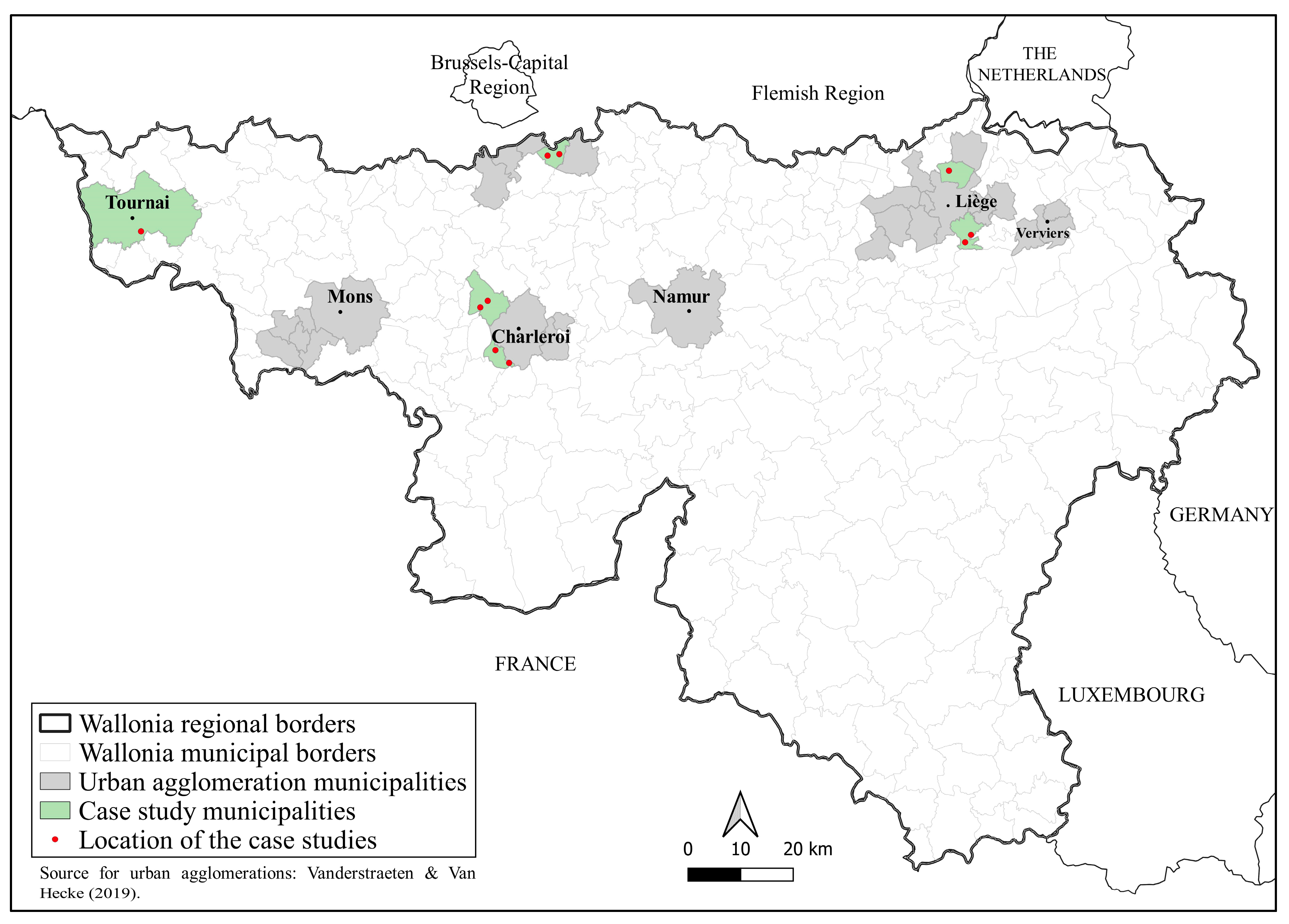
To grasp the roles of these agricultural lands, we opted for a grounded theory approach. We developed a qualitative research design based on a deep analysis of ten land and real estate assets located within urban conurbations to identify the services these agricultural lands provide and the different pressures they face. The case studies were selected after an inventory of the agricultural land plots adjacent to urban areas. This inventory was based on remote sensing analysis and a first field visit to select cases corresponding to land and real estate associated with agricultural holdings in different urban conurbations (Charleroi, Liège, Tournai, Walloon Brabant in the south of Brussels). These conurbations differ according to the urbanisation process and agricultural practices. Ten case studies were selected in Chaudfontaine (Liège), Courcelles (Charleroi), Herstal (Liège), Montigny-le-Tilleul (Charleroi), Rixensart (Brussels), Tournai (Tournai) (Figure 1). Their analyses made it possible to identify the diversity of situations and the roles these peri-urban agricultural areas played.
For each case, we explored: the role(s) played by these agricultural lands within urban spaces, why they were preserved from urbanisation, and if they deserve increased protection (according to the local context, the agronomic characteristics or other services provided—environmental, social, recreational). Particular attention was paid to the pressures that these agricultural lands are facing or would face and to the possible strategies followed by Walloon farmers to minimise the constraints and maximise the benefits linked to urban proximity.
We collected information via satellite images, agricultural parcel data (allocation by the land use plan, types of crops, heritage elements, Natura 2000), field observations, and interviews with farmers and local authorities. Several elements were addressed during the interviews with the municipal services. The aim was to see how agriculture and agricultural areas are integrated into communal policies and the population’s everyday life. The main objective of the interviews with farmers was to record their farm’s evolution and any strategies the farmer developed and to identify the causes of these changes. The interviews also helped to better our understanding of the farm activities and their interactions with the local context.
The information was compiled in an analysis grid including several dimensions: personal (Who is the farmer?), structural (parcelling, crops, natural and cultural heritage), contextual (localisation, interlinkage with urban area, access to the field, ecological network), functional (workforce, agricultural and non-agricultural activities, selling channels), foresight (project), inclusiveness (roles for the municipalities and the neighbours), ecosystem services (biotopes, list of services, beneficiaries).
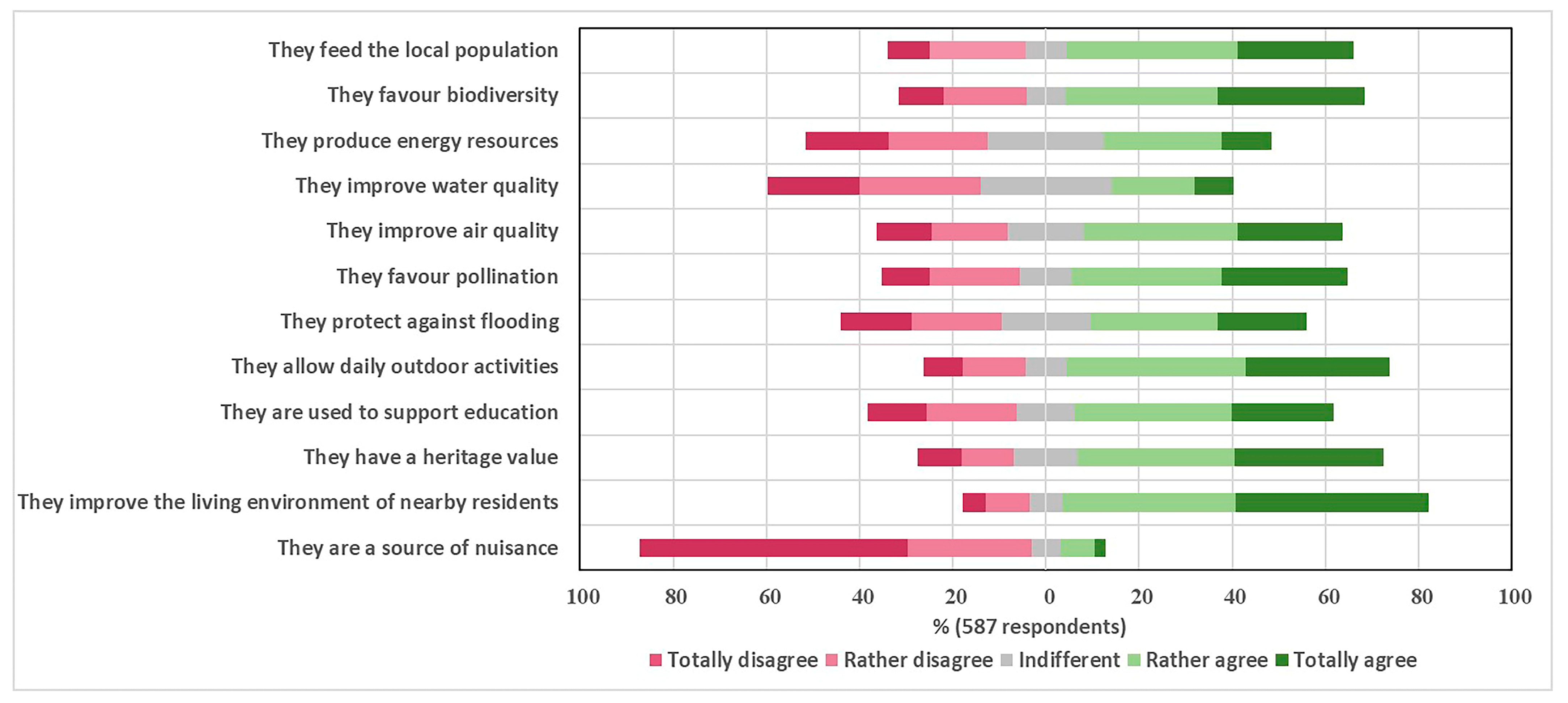
Additionally, we conducted an e-survey on the perception of agricultural lands and their functions. The aim was to collect a third point of view, besides the farmer and local authorities, on the roles of these lands. The target population was the Walloon population. We contacted the population via mailing lists and social networks and collected 587 responses. The questions address attachment, uses, and perceptions of agricultural lands. Most of the questions were formulated via Likert items of four levels. Even if the sampling technic presents biases because only the people interested in the topics took time to answer, it gives an insight into the perception of different services provided by agricultural lands in Wallonia (Table 1). Our sample comprises a majority of women and includes people between 18 and 79 years (with an average age of 36 years). As a result, women and young people are over-represented in our sample. Three living environments emerge among the respondents to the survey: 44.8% consider themselves to live in a village, 27.6% in the urban periphery, and 12.1% in the city centre. In addition, more than half of the Walloon respondents live near agricultural land (54.3% consider living within 500 m of the nearest agricultural land).
3. Results
3.1. Insights from the Field Studies
Beyond the agricultural function, primarily oriented towards conventional agriculture but including trends towards agro-environmental practices, we observed that the studied agricultural areas are a refuge for biodiversity and openings in the urban landscape. In half of the case studies, we found agricultural lands with diverse interesting habitats, such as wet meadows in Rixensart or calaminarian grassland with bushes in Chaudfontaine, considered areas of biological interest. Some of the municipalities have understood these issues and will consider them for the future planning of these areas. At the level of Wallonia, the promotion of agro-environmental methods and the multiplication of environmental assessments contribute to strengthening these functions. Nonetheless, agricultural activity should subsist and evolve in this direction to develop them.
From a recreational point of view, meadows for horses are present in most case studies. A golf project is also foreseen in Chaudfontaine. These uses weaken the food production function of these lands but maintain open spaces and could become a form of farm diversification if farmers are included in the process. We also noted the demand for walking through fields. Nevertheless, if the official atlas of local paths, published in 1841, informs many trails, this opportunity is restricted to the islet perimeter in most case studies. Indeed, the “privatisation” of some paths and trails by the farmers to limit public passage is common. Another concern is the visual access to certain blocks encircled and privatised by alignments of residences.
The e-survey shows that 89% of the respondents would be affected by the loss of agricultural lands near their houses, and 73% would protest to preserve them. Four services suggested during the survey are particularly acknowledged: feed the local population (62%), favour biodiversity (64%), allow outdoor activities (69%), and improve the living environment (79%) (Figure 2). Nonetheless, some respondents were more sceptical, probably because these services depend primarily on the type of agriculture the farmer practised. We also note that some services are more divided, such as the production of energy, the improvement of water quality, and the protection against flooding, depending once more on the type of agriculture practiced in the neighbourhoods.
The case studies allow identification of the reasons for the persistence of agricultural lands in the urban conurbation and reveal elements of their vulnerability. First, they showed that the fragmentation of the land estates makes them more vulnerable because they lost both their agricultural value and their role in biodiversity. A relatively large estate occupied by a family of farmers for several generations presents better prospects to remain cultivated even if the succession issue remains complex. The fragmentation of land ownership is also a concern, especially when constructions are allowed. Additionally, the financial crisis of 2008 led new investors to buy agricultural lands, which increased the land price and included new actors whose main objective was not agriculture but a return on investment. Even if the municipality owns the land, the temptation to profit by selling these lands for construction is high.
Nevertheless, we observed that the vicinity of areas recognised for their great biological interest could be considered an additional factor for the maintenance of integrated agriculture. Finally, the allocation provided by the land use plan (the main document with regulatory value for land use planning in Wallonia) is one of the most influential driving forces. We have seen the protective effect of the land use plan when lands are allocated to agriculture, green, or park areas but also the difficulty for authorities to preserve agricultural land intended for development. This land use plan dates from the 1970s and maintains an old town and country planning vision aiming primarily to boost economic development. However, due to the difficulties in changing the allocation from building to non-construction purposes lands, the land use plans were only partially revised.
Would the studied agricultural land deserve special protection? Some are already protected thanks to the land use plan or proximity to a site of great biological interest. Others depend on the vitality of the farm and require that authorities facilitate farming activities. Some seem too fragmented and embedded in the urban spaces to continue as conventional farming businesses. However, these spaces should not be indiscriminately artificialised because it would deprive the local and urban populations of a series of services, but also of the possibility of making land available for new forms of agriculture that can be developed on a few hectares and participate in the supply of local fresh products. Besides the concern of the land take, their non-agricultural use for other functions, such as recreation, deserves to be debated and evaluated. A precise impact assessment should inform the gains and losses. The protection of these spaces requires demonstrating the role they can play and raising awareness among authorities and populations.
3.2. A Synthetic Framework
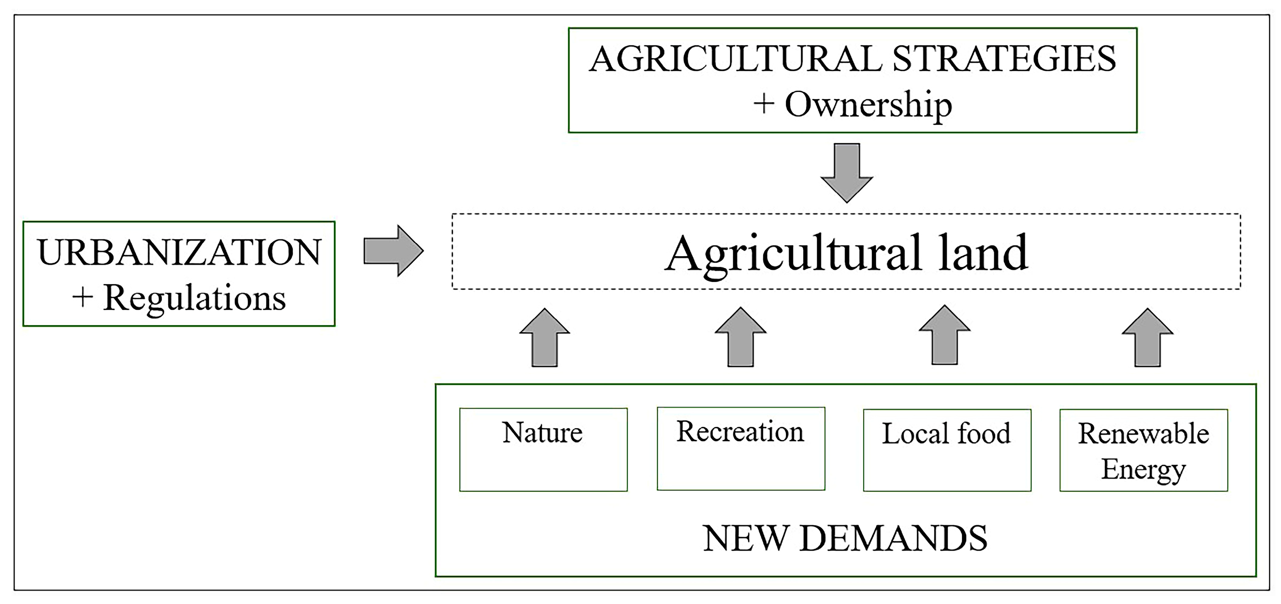
In Wallonia, the absence of a clear territorial framework and project to support multifunctional agriculture in urban and peri-urban areas led to a lack of clarity regarding the future of agricultural land at the edges of Walloon cities. Based on the case studies, Figure 3 distinguishes three types of driving forces influencing agricultural estates at the edges of Walloon cities.
The first set is linked with the farm’s characteristics and strategy. For example, will the farm continue to produce crops and livestock for the national and international market in a conventional or organic way, integrate the city market demand, or orient the farm toward providing direct services to the city (e.g., agrotourism, horses)? In addition, land ownership was crucial for the interviewees because it profoundly affects their farm’s future.
The second lot of driving forces is linked with the urbanisation pressure, especially the demand for new lands for construction. Nonetheless, in all the case studies, we have seen that legal regulations can contain or favour this urbanisation and the future of the agricultural landscape. Urban planning can contribute to reducing the consumption of agricultural land, for example, by imposing maximum building density rules or determining an order of priority for the building of some areas. In this way, the objective is to limit the urbanisation of agricultural land or, at least, to provide transition measures for farmers who can exploit land that would be destined for urbanisation. While communal authorities could play a role in protecting the agricultural land within their territory, for example, by becoming actors in the land market, today their role is often limited because they are often deprived of adequate tools.
The third lot is people’s demands or attention to developing nature, recreation, local food, and renewable energy. Even if they have no direct ability to decide the future of the agricultural land, local populations are increasingly exerting political pressure and also pressuring farmers in order to shape agricultural lands.
3.3. Future Trajectories
Based on these driving forces and depending on their strength, according to the local situation, we distinguished six possible trajectories for the agricultural landscape at the edges of the cities:
- Wasteland: A loss of any function (whether agricultural or not) of an estate could appear. This would be the case if the economic sustainability of the farm is no longer possible, in particular, due to negative pressures exerted by the urban environment (agricultural fragmentation, land pressure), and if the potential recreational and environmental services offered by these lands are limited (or due to the lack of interest by the owner). Therefore, wasteland could occur when urbanisation is conditioned by strong directives such as “zero artificialisation” which aims to reduce land take to zero by 2050 in Wallonia. This trajectory would lead to a loss of most of the services that this agricultural land provided to society;
- Conversion into a natural and/or leisure area: A total change of function (towards non-agricultural and non-residential functions) of the estate would occur if the economic sustainability of the farm is no longer possible and nobody wants to take it over. The recreational and/or natural potential of the estate could be valorised. Depending on the interests of the owner (or the community or public authorities), the previous agricultural estate could become a restricted recreational area led by economic purposes (e.g., golf or meadows for horses) or an open space for local communities and/or nature conservation (e.g., walking places, nature park);
- Total urbanisation: The urbanisation of the estate would take place if three conditions are met: the farmer who exploits the land stops his activity and the owner (whether public or private) wishes to sell to make a better profit, the demand for land development exists and the regulations allow the construction. This trajectory would lead to a loss of agricultural function and the environmental and recreational services provided;
- Balanced urbanisation: An area may be destined to be urbanised for various reasons (e.g., its allocation to the land use plan, its location, and the owner’s desire). However, urbanistic tools, particularly at the municipal level, could limit the density of inhabitants, impose environmental criteria, or preserve attractive landscape settings. If this trajectory leads to a total (or almost total) loss of the agricultural function, the impacts on the landscape and the environment could be weakened. This perspective would lead to the urbanisation of this area while maintaining some environmental amenities such as green spaces or a few hectares of land for market gardening;
- Conventional agriculture: This would be the case when farming is economically profitable and investments are dedicated to agricultural activity. As a result, the land estate would retain agriculture as its sole function without diversification into other agricultural or non-agricultural activities. This trajectory seems the most beneficial for agriculture, but the services that this peri-urban agricultural area could offer to the community would be limited;
- Multifunctional agriculture: To maintain agriculture’s viability in the peri-urban environment, some farms could diversify their activities. The decision could either come from the farmer or be initiated by the public authorities or communities that own the agricultural land. Several forms of diversification could emerge: diversification of agricultural functions (towards specialisation in one or more types of production or more sustainable agricultural practices (e.g., organic farming, integrated agriculture) or diversification towards other non-agricultural functions (such as tourism and leisure activities). Thus, the agricultural domain would be integrated into the urban environment as a multifunctional space, contributing to the local food supply, care of the environment, and the neighbours’ well-being.
4. Discussion
For several years, a renewed interest, both social and political, in urban and peri-urban agriculture has been highlighted at the European level and in Wallonia. One reason for this interest is the recognition that this form of agriculture integrates various social, economic, and environmental dimensions. It would impact a diversity of fields and could provide solutions to a set of current concerns. Examples include the growing development of environmental awareness among citizens, increased concern about food safety, and the increasing disappearance of open spaces and bio-diversity [29]. Nevertheless, if the citizens and the regional government are rediscovering the multiple services provided by agricultural lands, we observe that the agricultural landscape at the edge of Walloon cities is in a precarious situation.
The analysis of ten land and real estates led to the detection of the main driving forces influencing the prospects for agricultural lands at the cities’ edge. While the synthetic framework is based on a few case studies in Wallonia, it constitutes a good starting point for other studies. Regarding peri-urban agriculture, the literature underlines three essential dimensions: (1) the spatial dimension (it is practised in cities or on the outskirts of them); (2) the functional dimension (agricultural and non-agricultural activities maintain reciprocal functional links with cities and their inhabitants); (3) the evolutionary dimension (these areas and activities are constantly adapting to meet local urban conditions) [30]. The pressures on agricultural activities within urban conurbations are considerable, but new demands and expectations could provide new opportunities to maintain farming [31,32]. Nevertheless, agricultural lands at the edges of cities should not be isolated islets continuing conventional farming but should evolve to participate directly in the city metabolism [33]. The Walloon government, in its Regional Policy Declaration (2019–2024), insists on a set of issues that can be linked to peri-urban agriculture. In particular, it insists on promoting “the development of quality and local food belts” and encouraging short supply chains by supporting local producers. It intends to “pay particular attention to the preservation of agricultural land and its use for food purposes”. It also plans to strengthen the ecological network by improving the “deployment of nature in the city” and “the coexistence of human and economic activities with nature”, but also to support “agricultural biodiversity [...] in arable crop areas” [34]. In addition, the Regional Policy Declaration (DPR) also insists on the objective of gradually limiting land take to put an end to it by 2050. In addition to farming and diversification activities, the agricultural zone of the land use plan is also intended “for the maintenance or formation of landscapes and the conservation of ecological balance”, which suggests that the legislator assigns these environmental functions, at least in part, to agriculture [34].
The development of peri-urban agriculture is confronted with two major shortcomings. The first is the lack of cooperation between all the users of these spaces or people impacted by them, positively and negatively. Indeed, the multiplicity of agriculture-related functions leads to the fact that agriculture can be considered a “common heritage”. As a result, cooperation between all the actors concerned (urban and environmental spheres (political or not), the food sector, tourism, etc.) would be necessary for its preservation and proper development [35]. Therefore, raising awareness among all stakeholders in the territory (including citizens) of the opportunities agricultural lands offer is a significant challenge. The second is the lack of clear legislation linked, among other things, to spatial planning, allowing the development of new agricultural initiatives [35] and providing thoughtful solutions to take into account the potential negative impacts of urbanisation (including agricultural fragmentation) on the proper functioning of agriculture [22]. Nevertheless, the dynamic character of agricultural lands at the edges of the cities requires flexibility to avoid “end-state” solutions [36].
The analysis of the European political context shows that, previously, European policies have largely neglected urban and peri-urban agriculture. This is due, in particular, to their “inflexible” nature, which does not always make them suitable for urban and peri-urban farms. This is particularly the case of the Common Agricultural Policy (CAP) in force from 2014 to 2020, which does not meet the specific needs of urban and peri-urban agriculture due to their particular characteristics (diversification, location in urban areas, etc.). Indeed, the eligibility conditions are rarely met. In some cases, the urban or peri-urban farm is not “sufficiently agricultural” to obtain support under the first pillar. In other cases, it is not “rural enough” to be supported by the second pillar and rural development programmes [29,37].
The challenges of the coming years will thus be to better integrate and develop the recognition of peri-urban agriculture within the different policy areas concerned. It will also be necessary to direct more thought to the measures that will have to be put in place at the local level to fully exploit the many facets of this agriculture. The importance of taking these challenges into account in future policies and tools made available by the European Union is therefore noted.
Our case studies underline that in addition to the agricultural dimensions, including the evolution of the food, fibre, and oil market; the agricultural policies; and the farmers’ strategies, two crucial elements shape the trajectories: land ownership and regulations. Henceforth, it will be essential to consider these two drivers which are regularly undermined in the literature and policy agenda.
5. Conclusions
In addition to the evidence from statistics and remote sensing analysis, this study at the level of the land estate pointed out driving factors (Figure 3) linked with three types of actors who behave mainly at three spatial levels: the farm, the neighbourhood, and the conurbation. Accordingly, the research constructed six scenarios and called for a better understanding of the complex system that shapes agricultural land evolution. These lands, praised in the literature and political documents because of offering many services to the city, are in precarious situations at the edges of the Walloon conurbations. They can take trajectories that will ruin or strengthen some services. It requires efforts to transform these pieces of land, mostly privately owned, into a common heritage with a common vision to improve the well-being and resilience of the city. It requires accompanying and encouraging farmers, including financially, to implement multifunctional agriculture. Tools, including charters amongst stakeholders, should be developed to favour access to the lands for farmers but also access, including visual access, for the public. We also saw that planning documents installed a path dependency from previous policies, whose values and objectives could be obsolete. However, smart solutions can be found at a local level to rectify this trend of land take; additionally, the public bodies or communities of citizens should reflect on the possibility of buying the lands to give directives following renewed values and the services expected. As mentioned in the literature, it is also wise to empower different policy levels to take care of agricultural lands and to correct decisions affecting the different spatial scales.
Author Contributions
Conceptualization, S.S. and L.P.; methodology, S.S.; investigation, L.P. and S.S.; formal analysis, S.S. and L.P.; data curation, L.P.; writing—original draft preparation, S.S. and L.P.; writing—review and editing, S.S. and L.P.; visualization, L.P.; supervision, S.S.; project administration, S.S. and L.P.; funding acquisition, S.S. All authors have read and agreed to the published version of the manuscript.
Funding
This research was funded by the Walloon Region through CPDT (Conférence Permanente du Développement Territorial). CPDT: R6 2020.
Institutional Review Board Statement
Not applicable.
Informed Consent Statement
Informed consent was obtained from all subjects involved in the study.
Data Availability Statement
For privacy reasons, the interviews of farmers, neighbours and civil servants are confidential. The other data concerning the ten case studies are available online via the report of the CPDT [12]. In addition, the data from the e-survey can be shared upon request to the corresponding author.
Acknowledgments
We thank the Research Centre on Territorial, Urban and Rural Sciences (Lepur) of the University of Liege for their contribution to the field studies and Mary Cawley (NUI Galway) for language editing.
Conflicts of Interest
The authors declare no conflict of interest.
References
- The World Bank. Urban Population (% of Total Population)—Belgium. Available online: https://data.worldbank.org/indicator/SP.URB.TOTL.IN.ZS?locations=BE (accessed on 24 November 2022).
- Statbel. Structure de la Population en 2021. Available online: https://statbel.fgov.be/fr/themes/population/structure-de-la-population (accessed on 24 November 2022).
- Allen, A. Environmental Planning and Management of the Peri-Urban Interface: Perspectives on an Emerging Field. Environ. Urban 2003, 15, 135–148. [Google Scholar] [CrossRef] [Green Version]
- European Environment Agency. Urban Sprawl in Europe—The Ignored Challenge. Available online: https://www.eea.europa.eu/publications/eea_report_2006_10 (accessed on 24 November 2022).
- Rauws, W.S.; de Roo, G. Exploring Transitions in the Peri-Urban Area. Plan. Theory Pract. 2011, 12, 269–284. [Google Scholar] [CrossRef] [Green Version]
- Hedblom, M.; Andersson, E.; Borgström, S. Flexible Land-Use and Undefined Governance: From Threats to Potentials in Peri-Urban Landscape Planning. Land Use Policy 2017, 63, 523–527. [Google Scholar] [CrossRef]
- Shaw, B.J.; van Vliet, J.; Verburg, P.H. The Peri-Urbanization of Europe: A Systematic Review of a Multifaceted Process. Landsc. Urban Plan 2020, 196, 103733. [Google Scholar] [CrossRef]
- Wandl, D.I.A.; Nadin, V.; Zonneveld, W.; Rooij, R. Beyond Urban–Rural Classifications: Characterising and Mapping Territories-in-between across Europe. Landsc. Urban Plan 2014, 130, 50–63. [Google Scholar] [CrossRef]
- Geneletti, D.; La Rosa, D.; Spyra, M.; Cortinovis, C. A Review of Approaches and Challenges for Sustainable Planning in Urban Peripheries. Landsc. Urban Plan 2017, 165, 231–243. [Google Scholar] [CrossRef]
- Wandl, A.; Magoni, M. Sustainable Planning of Peri-Urban Areas: Introduction to the Special Issue. Plan. Pract. Res. 2017, 32, 1–3. [Google Scholar] [CrossRef] [Green Version]
- Hersperger, A.M.; Bürgi, M. Going beyond Landscape Change Description: Quantifying the Importance of Driving Forces of Landscape Change in a Central Europe Case Study. Land Use Policy 2009, 26, 640–648. [Google Scholar] [CrossRef]
- Pepe, L.; Zangl, S.; Legrand, A.; Hendrickx, S.; Schmitz, S. Prévenir la Mutation des Domaines Agricoles Périurbains. 2020. Available online: https://cpdt.wallonie.be/recherches/finalisees/annee-2020/prevenir-la-mutation-des-domaines-agricoles-periurbains-r6#:~:text=Il%20s’agit%20notamment%20de,d’un%20tourisme%20de%20proximit%C3%A9 (accessed on 25 November 2022).
- Bürgi, M.; Hersperger, A.M.; Schneeberger, N. Driving Forces of Landscape Change—Current and New Directions. Landsc. Ecol. 2005, 19, 857–868. [Google Scholar] [CrossRef]
- Brandt, J.; Primdahl, J.; Reenberg, A. Rural Land-Use and Landscape Dynamics—Analysis of “driving Forces” in Space and Time. In Land-Use Changes and Their Environmental Impact in Rural Areas in Europe; Krönert, R., Baudry, J., Bowler, I.R., Reenberg, A., Eds.; Man and the Biosphere Series; Unesco: Paris, France, 1999; pp. 81–102. [Google Scholar]
- Lee, Y.-C.; Ahern, J.; Yeh, C.-T. Ecosystem Services in Peri-Urban Landscapes: The Effects of Agricultural Landscape Change on Ecosystem Services in Taiwan’s Western Coastal Plain. Landsc. Urban Plan 2015, 139, 137–148. [Google Scholar] [CrossRef]
- Žlender, V.; Ward Thompson, C. Accessibility and Use of Peri-Urban Green Space for Inner-City Dwellers: A Comparative Study. Landsc. Urban Plan 2017, 165, 193–205. [Google Scholar] [CrossRef] [Green Version]
- Arnaiz-Schmitz, C.; Herrero-Jáuregui, C.; Schmitz, M.F. Recreational and Nature-Based Tourism as a Cultural Ecosystem Service. Assessment and Mapping in a Rural-Urban Gradient of Central Spain. Land 2021, 10, 343. [Google Scholar] [CrossRef]
- Olsson, E.G.A.; Kerselaers, E.; Søderkvist Kristensen, L.; Primdahl, J.; Rogge, E.; Wästfelt, A. Peri-Urban Food Production and Its Relation to Urban Resilience. Sustainability 2016, 8, 1340. [Google Scholar] [CrossRef] [Green Version]
- Frantál, B.; Van der Horst, D.; Martinát, S.; Schmitz, S.; Teschner, N.; Silva, L.; Golobic, M.; Roth, M. Spatial Targeting, Synergies and Scale: Exploring the Criteria of Smart Practices for Siting Renewable Energy Projects. Energy Policy 2018, 120, 85–93. [Google Scholar] [CrossRef]
- Willemen, L. Mapping and Modelling Multifunctional Landscapes. Ph.D. Thesis, Wageningen University, Wageningue, The Netherlands, 2010. Available online: https://library.wur.nl/WebQuery/hydrotheek/1935827 (accessed on 25 November 2022).
- Bousbaine, A.; Schmitz, S. Relocalizing Food Systems for Everyone, Everywhere? Reflections on Walloon Initiatives (Belgium). In Rural Transformations: Globalization and Its Implications for Rural People, Land, and Economies, 1st ed.; Barcus, H., Jones, R., Schmitz, S., Eds.; Routledge: London, UK, 2022; Chapter 13. [Google Scholar]
- Peri-urban region platform Europe. Peri-Urban Open Space: How Multi-Functional Land Use Can Bring Multiple Benefits—Purple. 2020. Available online: https://www.purple-eu.org/home/publications/topic-papers-on-peri-urban-issues/peri-urban-open-space-how-multi-functional-land-use-can-bring-multiple-benefits/ (accessed on 25 November 2022).
- Baró, F.; Gómez-Baggethun, E.; Haase, D. Ecosystem Service Bundles along the Urban-Rural Gradient: Insights for Landscape Planning and Management. Ecosyst. Serv. 2017, 24, 147–159. [Google Scholar] [CrossRef] [Green Version]
- Rouget, N. Les Dynamiques Agricoles dans les Espaces Urbains et Periurbains. Diversification et Stratégies D’Adaptation des Agricultures. Les cas des Périphéries sud-est de Lille et Nord de Lens. Ph.D. Thesis, Université de Nanterre, Paris, France, 2008. Available online: https://tel.archives-ouvertes.fr/tel-00477267/file/Textes.pdf (accessed on 25 November 2022).
- Zasada, I. Multifunctional Peri-Urban Agriculture—A Review of Societal Demands and the Provision of Goods and Services by Farming. Land Use Policy 2011, 28, 639–648. [Google Scholar] [CrossRef]
- McEldowney. Urban Agriculture in Europe: Patterns, Challenges and Policies. 2017. Available online: https://www.europarl.europa.eu/thinktank/en/document/EPRS_IDA(2017)614641 (accessed on 25 November 2022).
- Prové, C. The Politics of Urban Agriculture: An International Exploration of Governance, Food Systems, and Environmental Justice. Ph.D. Thesis, University of Ghent, Ghent, Belgium, 2018. Available online: https://biblio.ugent.be/publication/8546776 (accessed on 25 November 2022).
- Vanderstraeten, L.; Van Hecke, E. Les régions urbaines en Belgique. Belgeo 2019, 1, 32246. [Google Scholar] [CrossRef] [Green Version]
- Piorr, A.; Zasada, I.; Doernberg, A.; Zoll, F.; Ramme, W. Research for AGRI Committee—Urban and Peri-Urban Agriculture. 2018. Available online: https://www.europarl.europa.eu/thinktank/en/document/IPOL_STU(2018)617468 (accessed on 25 November 2022).
- Nahmias, P.; Le Caro, Y. Pour une Définition de L’Agriculture Urbaine: Réciprocité Fonctionnelle et Diversité des Formes Spatiales. Environ. Urbain/Urban Environ. 2012, 6, 437. Available online: http://journals.openedition.org/eue/437 (accessed on 25 November 2022).
- Wilson, G.A. Global Multifunctional Agriculture: Transitional Convergence between North and South or Zero-Sum Game? Int. J. Agric. Sustain. 2008, 6, 3–21. [Google Scholar] [CrossRef]
- Wästfelt, A.; Zhang, Q. Reclaiming Localisation for Revitalising Agriculture: A Case Study of Peri-Urban Agricultural Change in Gothenburg, Sweden. J. Rural Stud. 2016, 47, 172–185. [Google Scholar] [CrossRef]
- Schmitz, S. Du new urbanism au new ruralism: Un débat en cours sur de nouvelles visions de l’avenir des campagnes aux Etats-Unis. Géocarrefour 2008, 83, 331–336. [Google Scholar] [CrossRef]
- Gouvernement Wallon. Déclaration de Politique Régionale Wallonne 2019–2024. Available online: https://www.wallonie.be/sites/default/files/2019-09/declaration_politique_regionale_2019-2024.pdf (accessed on 25 November 2022).
- Rogge, E.; Kerselaers, E.; Prové, C. Envisioning Opportunities for Agriculture in Peri-Urban Areas. In Metropolitan Ruralities; Andersson, L., Sjöblom, S., Granberg, L., Ehrström, P., Marsden, T., Eds.; Emerald Group Publishing: Bingley, UK, 2016; Volume 23, pp. 161–189. [Google Scholar]
- Steiner, F. Frontiers in Urban Ecological Design and Planning Research. Landsc. Urban Plan 2014, 125, 304–311. [Google Scholar] [CrossRef]
- Curry, N.; Reed, M.; Keech, D.; Maye, D.; Kirwan, J. Urban agriculture and the policies of the European Union: The need for renewal. Span. J. Rural Dev. 2014, 5, 91–106. [Google Scholar] [CrossRef]
Figure 1.
Location of the Walloon urban agglomerations and the case studies [28].
Figure 1.
Location of the Walloon urban agglomerations and the case studies [28].

Figure 2.
Perceptions of the Walloons about the services that agricultural lands can offer near their residence.
Figure 2.
Perceptions of the Walloons about the services that agricultural lands can offer near their residence.

Figure 3.
The three main driving forces influencing agricultural estates at the edge of Walloon cities.
Figure 3.
The three main driving forces influencing agricultural estates at the edge of Walloon cities.


Table 1.
Profile sample (n = 587).
| Attributes | Categories | Percentages |
|---|---|---|
| Gender | Female | 67.6 |
| Male | 32.4 | |
| Age | 18–24 years | 23.5 |
| 25–54 years | 59.3 | |
| 55–64 years | 12.4 | |
| More than 64 years | 4.8 | |
| Declared living environment | Isolated in the countryside | 5.3 |
| In a hamlet | 6.6 | |
| In a village | 44.8 | |
| In a town | 3.6 | |
| In the urban periphery | 12.1 | |
| In the city centre | 27.6 | |
| Proximity of the residence of the nearest agricultural lands | Less than 500 m | 54.3 |
| Between 500 m and 1 km | 15.8 | |
| Between 1 km and 3 km | 13.8 | |
| Between 3 km and 5 km | 5.9 | |
| More than 5 km | 10.2 |
Disclaimer/Publisher’s Note: The statements, opinions and data contained in all publications are solely those of the individual author(s) and contributor(s) and not of MDPI and/or the editor(s). MDPI and/or the editor(s) disclaim responsibility for any injury to people or property resulting from any ideas, methods, instructions or products referred to in the content. |
© 2022 by the authors. Licensee MDPI, Basel, Switzerland. This article is an open access article distributed under the terms and conditions of the Creative Commons Attribution (CC BY) license (https://creativecommons.org/licenses/by/4.0/).
Share and Cite
MDPI and ACS Style
Schmitz, S.; Pepe, L. The Precariousness of Walloon Peri-Urban Agricultural Lands. Land 2023, 12, 105. https://doi.org/10.3390/land12010105
AMA Style
Schmitz S, Pepe L. The Precariousness of Walloon Peri-Urban Agricultural Lands. Land. 2023; 12(1):105. https://doi.org/10.3390/land12010105
Chicago/Turabian StyleSchmitz, Serge, and Lauriano Pepe. 2023. "The Precariousness of Walloon Peri-Urban Agricultural Lands" Land 12, no. 1: 105. https://doi.org/10.3390/land12010105
Note that from the first issue of 2016, this journal uses article numbers instead of page numbers. See further details here.