Article

Spatial and Temporal Patterns of Urban Land Use Structure in Small Towns in China

1
School of Economics, Minzu University of China, Beijing 100081, China
2
Town Planning and Research Institute, China Architecture Design and Research Group, Beijing 100044, China
3
College of Urban Economics and Public Administration, Capital University of Economics and Business, Beijing 100070, China
4
Beijing Key Laboratory of Megaregions Sustainable Development Modelling, Capital University of Economics and Business, Beijing 100070, China
*
Author to whom correspondence should be addressed.
Land 2022, 11(8), 1262; https://doi.org/10.3390/land11081262
Submission received: 27 July 2022 / Revised: 3 August 2022 / Accepted: 5 August 2022 / Published: 6 August 2022
(This article belongs to the Special Issue Sustainable Rural Transformation under Rapid Urbanization)

Abstract

:
This study analyzes the spatial and temporal characteristics of urban land use structure of more than 18,000 small towns in China by using the National Urban Land Use Survey Data between 2009 and 2013. It finds that the urban land area of small towns expanded rapidly during the research period. The spatial pattern of urban land use structure in small towns exhibits significant regional differences. Small towns in developed coastal regions, particularly those located in global urban areas, have a higher urban land use scale relative to small towns in central and western regions. However, the urban land use scale of small towns located in less developed inland areas has grown faster. The spatial distribution of urban stock land in small towns is mainly influenced by demographic and socio-economic factors. However, the spatial distribution of new urban land is primarily influenced by the land supply policy, which is tilted toward the central and western regions. In terms of structure, the proportion of production and living land in small towns is high, while the proportion of public services and facilities land is low. This trend is being strengthened, with commercial service land and industrial, mining, and storage land becoming the major drivers for the rapid rise of urban land in small towns. The allocation of construction land quotas should be consistent with the direction of population movement and the demands of socioeconomic development.

1. Introduction

Land is the space and carrier for the development of social and economic activities. Whether urban land use and its structure are reasonable is directly related to the realization of urban functions and the future of economic development [1,2,3]. With the rapid progress of industrialization and urbanization, urban land use has also undergone considerable changes [4,5,6]. A series of land use problems, such as rapid expansion of urban land [7,8,9], disproportionate urban land use structure [10,11,12], and lower land use efficiency [13,14,15,16], has emerged, directly affecting the sustainable development of cities.
In the context of limited land resources but rapid urbanization, urban land use structure and its evolution have gradually elicited extensive attention from scholars and policy makers [3,17,18,19]. Scholars in the fields of urban economics, sociology, and geography have conducted numerous successful studies on urban land use, including the characteristics of urban land expansion at different spatial scales [20,21], the spatial and temporal characteristics of urban land use structure [17,22,23], and the evaluation of urban land use efficiency [12,18,19]. Notably, urban land use is an important issue not only for cities but also for small towns [24]. However, most current studies that explored the spatiotemporal characteristics of urban land use structures have been conducted at the national, provincial, and city levels, while relatively few studies have been performed on small towns, which are important components of urban networks.
Unlike Western countries, small towns play a special role in the Chinese urban system [25]. As a link between urban and rural areas, small towns exhibit urban and rural characteristics; they are transition zones between urban and rural areas and geographical carriers for promoting rural industrialization and local urbanization [26,27]. The report of the 19th National Congress of China proposes building an urban system with the coordinated development of large, medium-sized, and small cities and small towns. As an important component of an urban system, small towns play a pivotal role in promoting the integration of urban and rural areas in China. However, urban land use is an important issue that has constrained the development of small towns in China [27]. Studies have pointed out that a series of problems exists in the urban land use of small towns in China, such as the lack of scientific planning, irrational and inefficient urban land use, and valuing the economic benefits while disregarding the ecological benefits of urban land use structure [28,29,30]. However, limited by the urban–rural dichotomy, studies on land use in China are frequently divided into the urban and rural factions, while small towns are largely neglected [31].
By analyzing the spatial and temporal characteristics of the total amount and structure of urban land use in more than 18,000 small towns in China during 2009–2013, this study can provide a clearer understanding of the urban land use characteristics of small towns in China and a basis for guiding land use policies in small towns. The contributions of this study are mostly reflected in the following three aspects. First, this study uses data from the 2009–2013 National Urban Land Use Survey; these data cover all small towns in China and provide a more comprehensive, systematic, and thorough understanding of the spatial and temporal characteristics of land use in small towns. Second, this study intends to generalize regional differences in the characteristics of urban land expansion in small towns. Significant regional differences in urban land use characteristics are observed between small towns located in developed coastal areas and backward inland areas and between urban agglomerations and other regions. These differences are influenced by both the market demand and land supply policies. By analyzing regional differences in the urban land use characteristics of small towns, this study provides support for understanding the urban land use expansion mechanism of small towns in China and adjusting the spatial allocation policies of land resources. Third, this study examines the urban land use structure of small towns and its changes. Existing studies have analyzed the overall characteristics of urban land use in small towns, but neglected their structural characteristics. Although some studies explored the land use structure of small towns, they have mainly studied the structural characteristics of urban land and agricultural land in small towns, and less explored the structural features within urban land. A reasonable urban land use structure can promote the function and land use efficiency of small towns. This study analyzes the urban land use structure of small towns, which has important practical value for guiding the planning and construction of small towns.

2. Literature Review

Research on urban land use in small towns in China involves a number of disciplinary fields and has resulted in a relatively rich body of literature; however, a systematic theoretical system has not yet been formed. The current research focuses on the following three aspects. The first branch of literature explores the expansion of urban land use in small towns and its influencing factors [32,33]. Most studies have found that urban land in small towns is expanding rapidly [34,35]. Studies have pointed out that the natural environment plays a fundamental and limiting role in the expansion of urban land, and the urban land scale of small towns is larger in areas with better natural conditions, such as flat topography, lower elevation, and along the coast and rivers [32]. Nevertheless, physical geographic constraints on the urban land scale of small towns exhibit a decreasing trend, whereas the influences of urban population growth, economic development level, industrialization process, and local policies have been increasing. Studies have stated that economic growth causes population clustering and further drives the expansion of urban land [33]. Continuous industrialization and urbanization have driven the transfer of industries from large cities to small towns [36,37]. Considering the issues of urban repositioning, old city renovation, high land price, and environmental problems, large cities relocate firms to small towns or transfer a segment of their spare part production to small towns, promoting the spatial reconfiguration of industries between large cities and small towns [38]. In addition, reforms in areas such as an agricultural land system, a household registration system, and an urban housing system exert significant effects on the expansion of land in small towns.
The second branch of literature explores the land use structure of small towns and its changes. Some studies used the administrative boundaries of towns as the research scope and explored the land use structure between urban land and other land, such as arable land, garden land, forest land, pasture land, and unused land [26,39,40,41,42]. Most studies have found that urban land in small towns is expanding rapidly, encroaching on agricultural and other land [26,42,43,44]. Due to the limitation of urban land use data in small towns in China, few studies have been conducted on the internal structural characteristics of urban land in small towns, and most of them are in the form of case studies. This type of study generally takes a certain area as the research object, and analyzes the spatial and temporal characteristics of the land use structure of small towns in the area through field surveys [45,46,47,48,49]. However, studies based on large samples to study the urban land use structure of small towns in China are extremely scarce. There are only two studies that have examined the urban land use structure of small towns. Zhao and Lyu used the survey data of 121 towns from the Ministry of Housing and Urban–Rural Development in 2016 to study the characteristics of the urban land use structure of small towns in China. They found that residential land use was higher in small towns due to the hollowing out of industries, and the proportion of industrial land use was larger in areas with high levels of economic development [30]. Chen and Wu analyzed the structural characteristics of construction land in small towns on the basis of data from 24 small towns in 8 provinces [50].
The third branch of literature explores the problems, causes, and policy recommendations of urban land use in small towns. One study pointed out that the expansion of urban land use in small towns occupies a large amount of agricultural land, sharply decreasing the area of arable land, and hindering agricultural development [28]. Small towns focus excessively on economic benefits while neglecting ecological benefits in urban land use, leading to serious land pollution and ecological environment deterioration [29]. The urban land use structure of small towns is unreasonable, with a large proportion of residential land and few public facilities and recreational areas [30]. The master plan of small towns is out of line with practice [51]. Countermeasures and suggestions for optimizing urban land use in small towns include tapping the stock of land in small towns, improving land compactness, optimizing land use structure, and enhancing land use efficiency [52].
Existing studies still have general shortcomings, which are also the motivation and purpose of the current study. First, existing studies on urban land use in small towns are frequently limited to a small number of town cases or confined to local areas, without comprehensive survey data at the national level. Second, many studies have only explored the characteristics and changes in the structure of urban land and agricultural land in small towns in China, with less research on the structural characteristics within urban land. Third, regional differences are rarely mentioned in the studies of the urban land use characteristics of small towns. In consideration of the aforementioned limitations, the current study uses data from the China Urban Land Use Survey from 2009 to 2013 to examine the spatial and temporal pattern characteristics of urban land use structure in more than 18,000 small towns, with the purpose of providing recommendations for the formulation and implementation of differentiated and targeted land policies.

3. Research Methodology and Data Sources

3.1. Research Methodology

Scholars have mostly used information entropy models, spatial autocorrelation analysis, and the offset share models to study the spatial and temporal characteristics of urban land use structures. The current study uses spatial autocorrelation analysis and offset share model to quantitatively measure the spatial and temporal pattern characteristics of the urban land use structure of small towns in China during 2009–2013 [53].

3.1.1. Spatial Autocorrelation Analysis

Spatial autocorrelation has been widely used as a common exploratory spatial data analysis (ESDA) method to analyze the spatial patterns of geographic phenomena [54,55]. Tobler’s First Law of Geography states that the properties of spatial units within a region are connected, and that specific geographic properties are interrelated in spatial distribution, which is the basis for the formation of spatial autocorrelation theory. Moran’s I index is one of the basic indicators for autocorrelation analysis of spatial data, characterizing the degree of spatial correlation of specific variables or characteristics of each unit in the region. Therefore, this study uses the global Moran’s I index and the local Moran’s I index to analyze the global and local spatial pattern characteristics of urban land use in small towns in China.
  • Global Moran’s I index
Global Moran’s I index is mostly used to measure the general trend of spatial correlation of attribute values of spatially adjacent and nearby units in the study area, and its value is usually between [−1, 1]. At a given level of significance, a Moran’s I value greater than 0 indicates a significant spatial clustering of the overall pattern of urban land scale; a Moran’s I value less than 0 indicates a significant spatial divergence of the overall pattern; a Moran’s I value of 0 indicates a random distribution with no spatial autocorrelation. The calculation formula is as follows.
I = n i = 1 n j = 1 n w i j ( X i X ¯ ) ( X j X ¯ ) ( i = 1 n j = 1 n w i j ) i = 1 n ( X i X ¯ ) 2
where Xi and Xj are the attribute values in regions i and j, respectively; n is the total number of regions; the spatial weight matrix Wij represents the linkage relationship between the regions i and j, with spatial adjacency as 1 and non-adjacency as 0; X ¯ is the average of the attribute values.
2.
Local Moran’s I index
The local Moran’s I was proposed by Anselin [56]. It is a decomposed form of the global Moran’s I to discriminate the differences of specific attributes between a single region and the surrounding regions. Its formula is as follows.
I i = ( X i X ¯ ) S 2 j w i j ( X j X ¯ )         ( i j )
where Ii is the local Moran’s I index; S is the standard variance of X; X ¯ is the mean of Xi. Based on the local autocorrelation index, the correlation status of the area can be observed, which is divided into four types: HH (high value clustering), HL (high value surrounded by low value), LH (low value surrounded by high value), and LL (low value clustering).

3.1.2. Offset Share Model

In the 1960s, Dunn and other scholars in the United States proposed the offset share model, a method for studying regional economic development. The basic idea of this model is to compare the economic development of a study area with that of a reference region (typically the higher administrative region or the whole country) and to decompose the total regional economic growth of the study area into three aspects, i.e., the national share component (NS), industrial mix component (IM), and regional shift component (RS), over a certain period [57]. The offset share model has been widely used in various research fields, such as industrial structure optimization and urban land use structure evolution [53,58]. The current study uses the offset share model to explore dynamic changes and spatial allocation in the land use structure of small towns in China.
  • NS denotes the area in which a certain type of construction land i in a small town j can grow with reference to the average growth rate (R) of the total land area of small towns nationwide. NS reflects the “rationing effect” of construction land growth of all towns in each town.
    N S i j = U i j 0 R
    R = i = 1 S j = 1 M ( U i j t ) i = 1 S j = 1 M ( U i j 0 ) i = 1 S j = 1 M ( U i j 0 )
    where U i j 0 and U i j t are the area of the construction land of category i of small town j in the beginning and end of the study period, respectively.
  • IM denotes the difference between the area in which a certain type of construction land i in a small town j can grow with reference to the average growth rate (Ri) of that type of construction land and NSij. It can identify whether a particular type of construction land is at a growth advantage.
    I M i j = U i j 0 ( R i R )
    R i = j = 1 M ( U i j t ) j = 1 M ( U i j 0 ) j = 1 M ( U i j 0 )
  • RS denotes the difference between the area in which a certain type of construction land i in a small town j can grow in accordance with the actual growth rate (Rij) of that type of land in the town and the area that can grow in accordance with the average growth rate (Ri) of that type of land in all towns nationwide. It can identify the competitive advantage of a particular type of construction land in a town relative to other small towns.
    R S i j = U i j 0 · ( R i j R i )
    R i j = U i j t U i j 0 U i j 0

3.2. Study Area and Data Sources

The data used in this study comes from the Urban Land Use Survey Data in China. To comprehensively grasp the land use situation in China’s cities and towns, the Ministry of Land and Resources has been summarizing the current land use status of each piece of land in cities and towns, forming national urban land use data. These data report the area of different types of urban land at various scales (towns–counties–cities–provinces–nation). This survey divides urban land into eight categories: commercial service land; industrial, mining, and storage land; residential land; public administration and public service land; transportation land; water and water facilities land; special use land; and other land. Due to the sensitivity of land data, publicly available urban land use data are generally released at the city level, which is why studies on the urban land use structure of small towns in China are extremely scarce. This study analyzes the spatial and temporal characteristics of urban land expansion and structure by using data from more than 18,000 small towns for 5 consecutive years (2009–2013). Although the data period is between 2009 and 2013, this study still contributes to a more comprehensive and detailed understanding of the characteristic facts of the urban land use structure of small towns in China.
The spatial distribution of small towns is shown in Figure 1. Small towns in China are mostly concentrated in the provinces southeast of the Heihe–Tengchong line. The definition of small towns in China is from an administrative perspective. Thus, it is inconsistent with the definition of small towns in Western countries. In general, the administrative area of small towns consists of two parts: the central urbanized area and the rural and agricultural land in the periphery [59]. By contrast, small towns in developed countries do not have a large rural population or agricultural land; moreover, the space of small towns is mostly urbanized areas [60,61]. This study focuses on the spatial and temporal patterns of land use in urbanized areas of small towns in China, which are also consistent and comparable with the definition of small towns in developed countries.

4. Spatial and Temporal Patterns of Urban Land Use in Small Towns in China

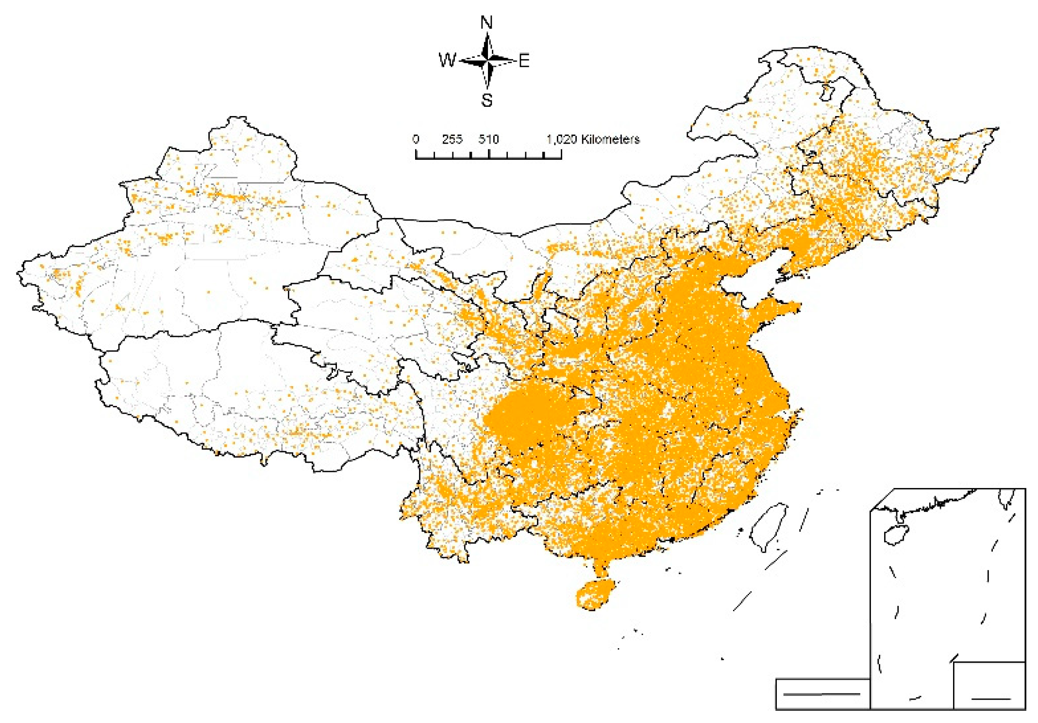
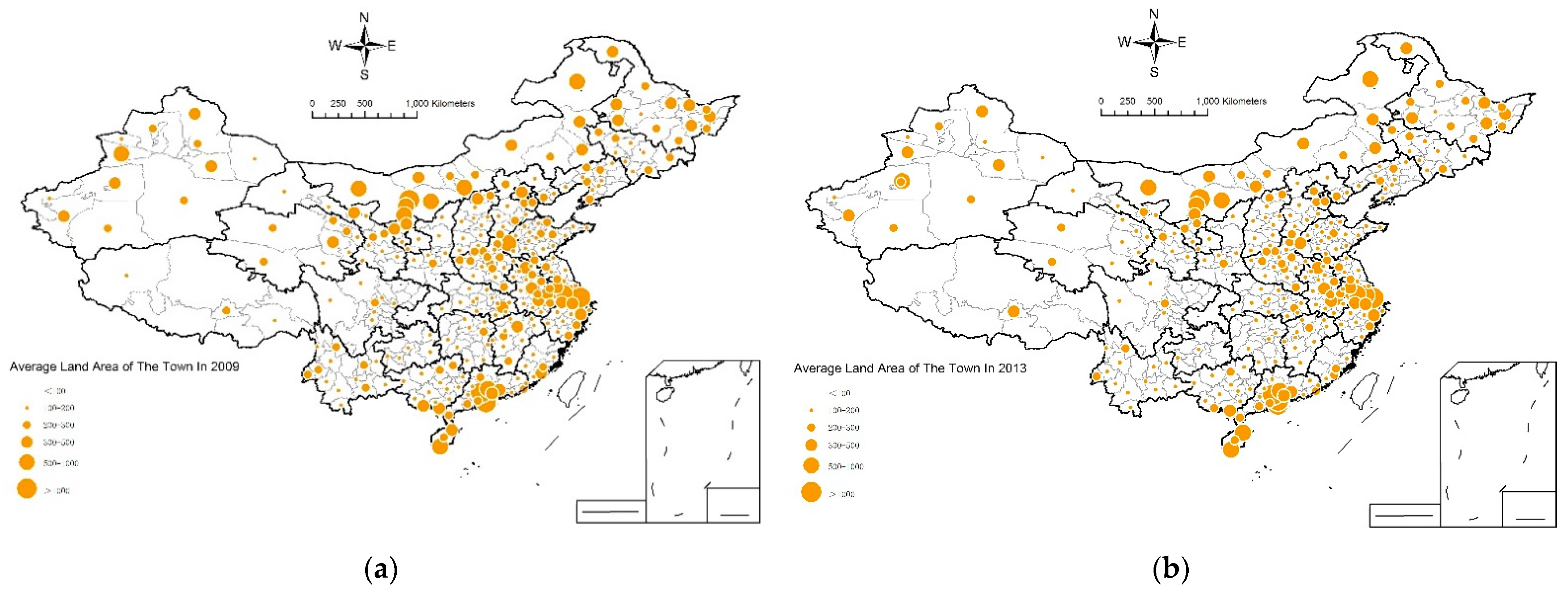
4.1. General Characteristics of Urban Land Use Scale in Small Towns

The total urban land area of small towns in China continues to expand rapidly, with growth rates exceeding those of city areas. In accordance with the National Urban Land Use Survey Data, the total urban land area of small towns in China was 44,039 km2 in 2013, an increase of 6748 km2 or 18.10% compared with 37,291 km2 in 2009. During the same period, the total population in small towns in China grew from 138 million to 152 million, an increase of only 10.14%. Meanwhile, the total urban land area of city areas increased from 35,327 km2 in 2009 to 39,649 km2 in 2013, i.e., an increase of 12.23%. The growth rate of urban land area in small towns exceeds the growth rate of urban land area in cities in the same period by 5.87 percentage points. Small towns in China were generally in a state of rough expansion during the study period, and population and land resources were not used in a coordinated manner.
The urban land area of small towns in China is relatively evenly distributed. Table 1 shows the number of small towns by urban land area. In 2013, 2104 small towns had urban land area below 0.2 km2, accounting for 11.60% of all small towns; 4093 small towns had urban land area between 0.2 km2 and 0.5 km2, accounting for 22.57% of all small towns; 4367 small towns had urban land area between 0.5 km2 and 1 km2, accounting for 24.08% of all small towns; 3370 small towns had urban land area between 1 km2 and 2 km2, accounting for 18.58%; 2447 small towns had urban land area between 2 km2 and 5 km2, accounting for 13.49%; 1754 small towns had urban land area of over 5 km2, accounting for 9.67%. Overall, the proportion of small towns with urban land area below 0.5 km2 decreased relatively from 38.37% in 2009 to 34.17% in 2013; the proportion of small towns with urban land area between 0.5 km2 and 1 km2 remained relatively stable at around 24%; the proportion of small towns with urban land area over 1 km2 increased from 37.62% in 2009 to 41.75% in 2013.
The urban land area of small towns exhibits a decreasing distribution trend from east to west, but the growth rate in the central and western regions is accelerating. Figure 2 shows the spatial distribution of average urban land area of small towns in China. Overall, the average urban land area of small towns in the eastern region is the largest. As illustrated in Table 2, the average urban land area of small towns in the eastern region was 2.40 km2 in 2013, i.e., 39.28%, 51.43%, and 16.61% higher than the average urban land area of small towns in the central, western, and northeastern regions, respectively. Small towns with large urban land area are mostly concentrated in the Pearl River Delta urban agglomeration, the Yangtze River Delta urban agglomeration, the Beijing–Tianjin–Hebei urban agglomeration, and some areas of Inner Mongolia and Xinjiang Provinces. The average urban land areas of small towns in the Pearl River Delta urban agglomeration, the Yangtze River Delta urban agglomeration, and the Beijing–Tianjin–Hebei urban agglomeration were 5.15, 3.00, and 2.18 km2, respectively, in 2013, while the average urban land area of small towns in other regions was only 1.75 km2. By studying the development and evolution of small towns in the Yangtze River Delta urban agglomeration, Luo and He pointed out that global urban areas have contributed significantly to the development of small towns [62]. Globalized production networks have expanded the growth space of small towns, high-speed transportation networks have reconfigured the regional role of small towns, and the upgrading of social consumption demand has provided new paths for small town development. In such a context, the evolution of small towns in global urban areas has accelerated and intensified in a manner that ordinary regions do not. Consequently, the land area of small towns in China’s three major urban agglomerations is significantly higher than those of other regions, particularly in the Pearl River Delta and Yangtze River Delta urban agglomerations, which have more mature urban networks. The report of the 19th National Congress of China proposed to build an urban pattern of coordinated development of large, medium-sized, and small cities and small towns with urban agglomerations as the mainstay. This strategy is based on the fact that urban agglomerations can promote the rapid development of small towns.
The growth rate of the urban land area of small towns in the central and western regions has accelerated. Figure 3 shows the spatial distribution of average growth rate of the urban land area of small towns in China between 2009 and 2013. Small towns in the western region recorded the fastest growth in urban land area, with the average urban land area increasing from 1.27 km2 in 2009 to 1.73 km2 in 2013, i.e., an increase of 24.63%. The western region is followed by the central region, wherein the average urban land area of small towns increased by 17.15%. Meanwhile, the average urban land area of small towns in the eastern and northeastern regions only increased by 10.40% and 7.38%, respectively, during the same period. The spatial expansion rate of small towns is closely related to the spatial allocation of construction land quotas. After 2003, more construction land quotas were allocated to the central and western provinces, leading to a divergence in the direction of land allocation and population movement. In particular, after the financial crisis in 2008, China implemented a 4 trillion spending plan and an investment strategy tilted toward the central and western regions to stimulate economic development, resulting in a greater concentration of land supply in the central and western regions [63]. Under such background, the land scale of small towns in the central and western regions is expanding rapidly.

4.2. Structural Characteristics of Urban Land Use in Small Towns

The proportion of productive and living urban land use in small towns is high, while the proportion of urban land use for public welfare is lower. In 2013, the proportion of productive land (including industrial, mining, and storage land and commercial service land) of small towns was 35.5%. The proportion of land for living purposes (residential land) was 34.2%, while that of land for public administration and services, transportation, and other public welfare purposes was 30.4% in total. Compared with the urban land use structure in cities, the proportion of productive and living land use in small towns is relatively higher. In 2013, the proportion of industrial, mining, and storage land and commercial service land for productive use in city areas was 33.3%, i.e., 2.2 percentage points lower than that in small towns. The proportion of residential land in urban areas is 31.9%, i.e., 2.3 percentage points lower than that in small towns. After decades of development, China’s industry has entered a period of adjustment. On the one hand, industries tend to move from big cities to small towns due to urban repositioning, the renovation of old cities, high land prices, and strong environmental regulation. On the other hand, scattered rural industries tend to move to small towns due to lagging infrastructure development and uneconomical scale. As an intermediate zone that links urban and rural areas, small towns exhibit the advantages of abundant labor with lower wages and easy access to land, creating conditions for industries to move to small towns and leading to the proportion of productive land, such as industrial, mining, and storage, to exceed that of city areas. In terms of living land, the residential pattern in small towns is mostly low, i.e., houses with 1–3 stories built by residents; thus, per capita living area is considerably larger than that in cities [30]. Simultaneously, public service and infrastructure development in small towns have been lagging, as reflected by the low proportion of land for transportation, public administration, and public services in small towns.
The urban land use structure of small towns has been continuously tilted toward industrial, mining, and storage land and commercial service land. As shown in Table 3, Industrial, mining, and storage land in small towns increased from 9575 km2 in 2009 to 12,585 km2 in 2013, i.e., an increase of 3010 km2 with a growth rate of 31.44%. Commercial service land increased from 2319 km2 to 3020 km2, i.e., an increase of 701 km2 with a growth rate of 30.23%. The proportion of the two land use classifications to all land use types also rose from 25.68% and 6.22% to 28.58% and 6.86%, respectively. The proportion of the two land use types rose from 25.68% and 6.22% to 28.58% and 6.86%, respectively. The growth rate of all types of urban land in small towns was higher than that in city areas, particularly industrial, mining, and storage land and commercial service land, which grew by 12.1 and 7.9 percentage points higher than those in city areas, respectively. The growth rates of transportation land and public administration and public service land were also 7.4 and 6.26 percentage points higher than those in city areas, respectively.

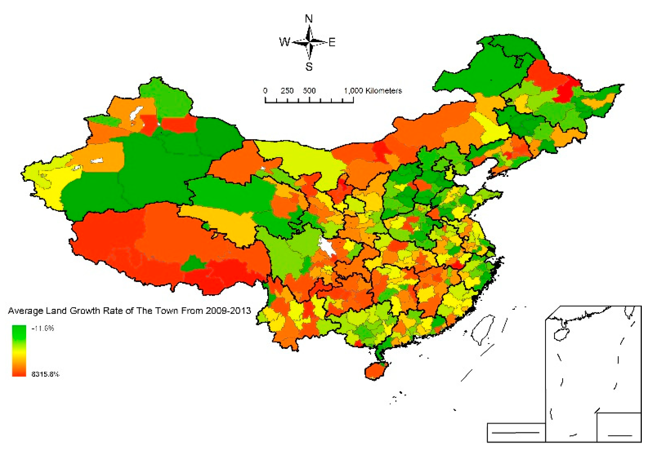
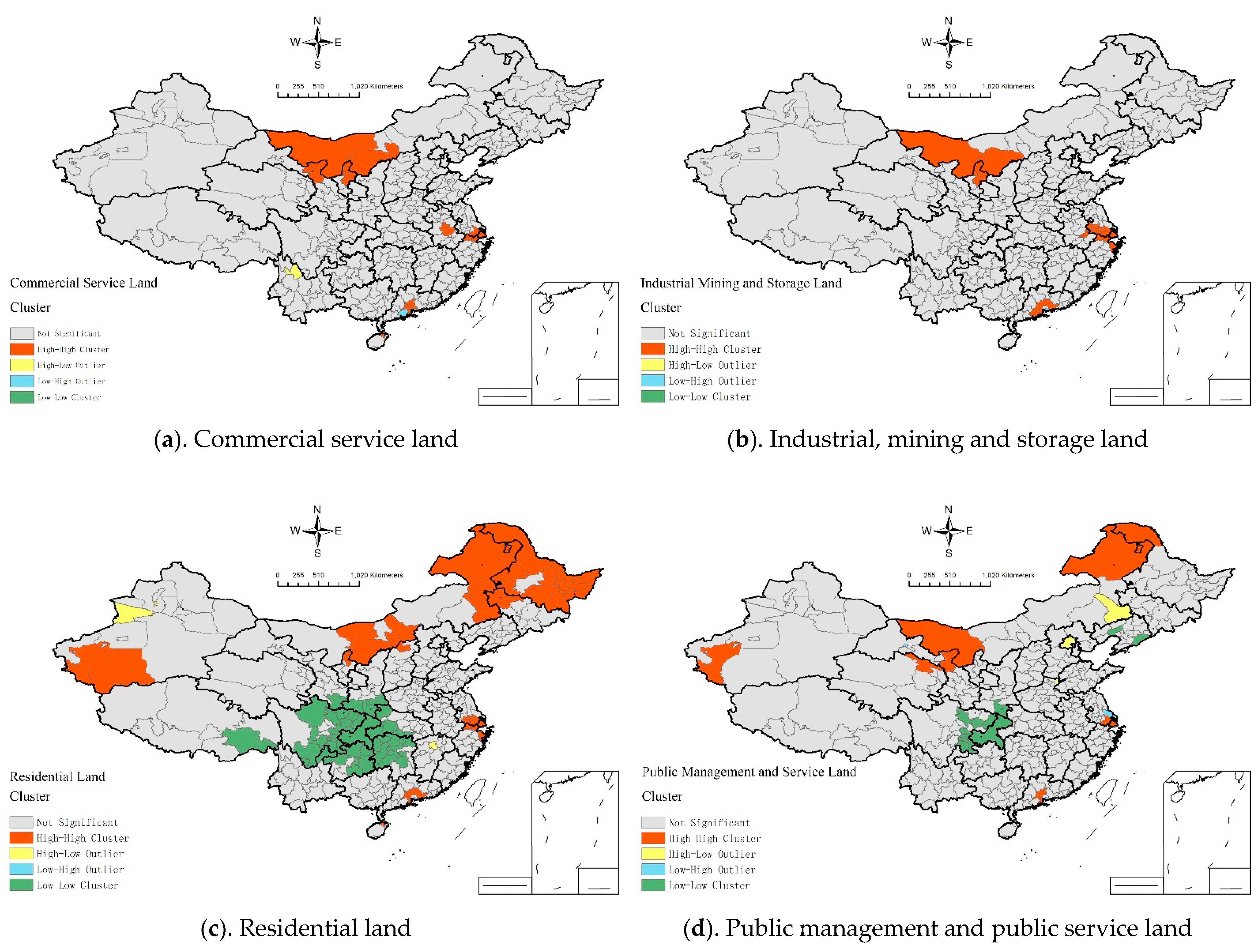
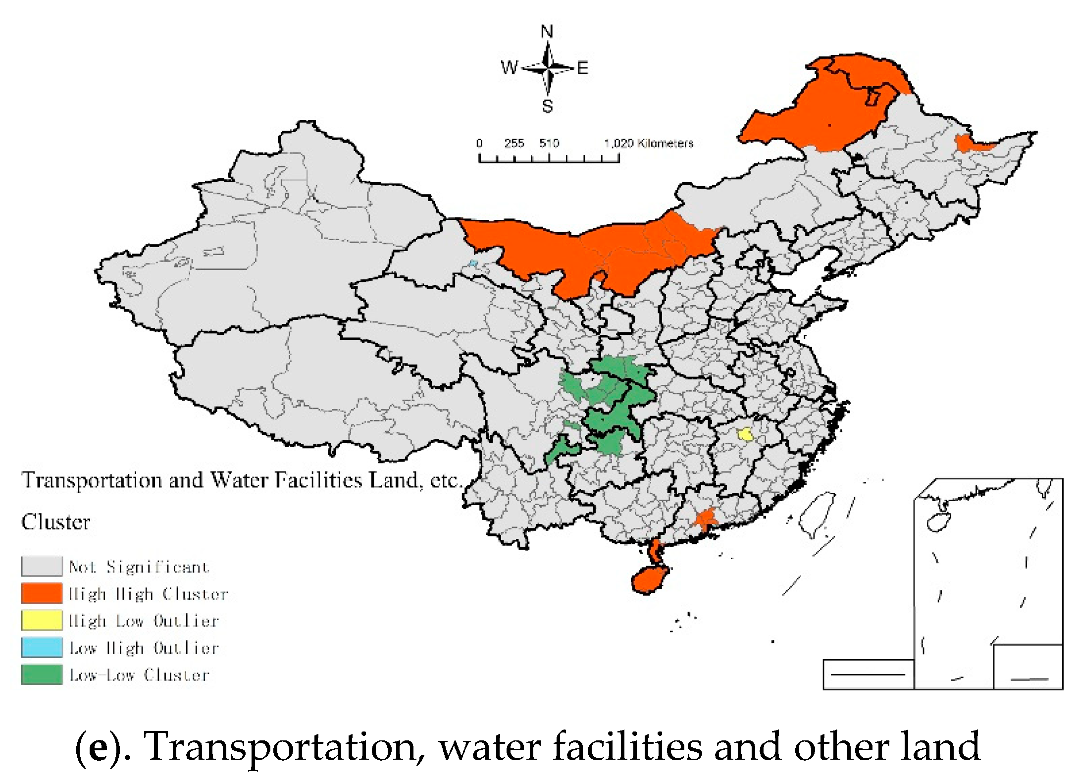
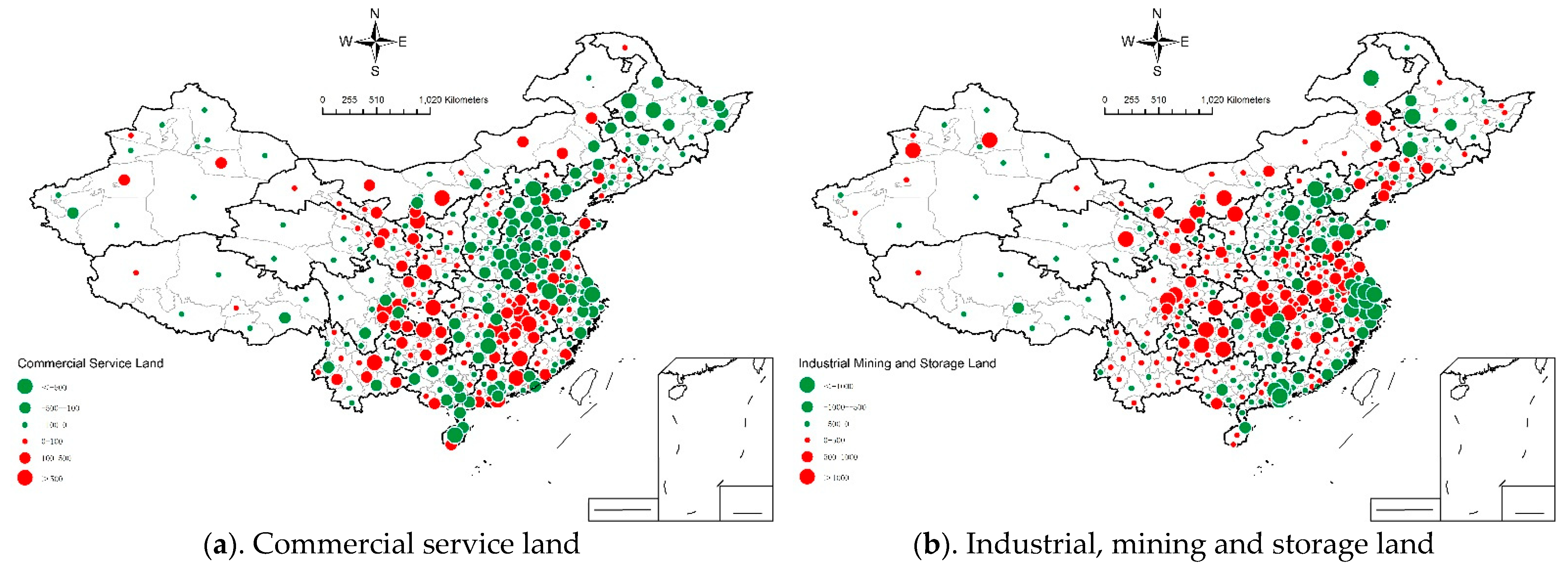
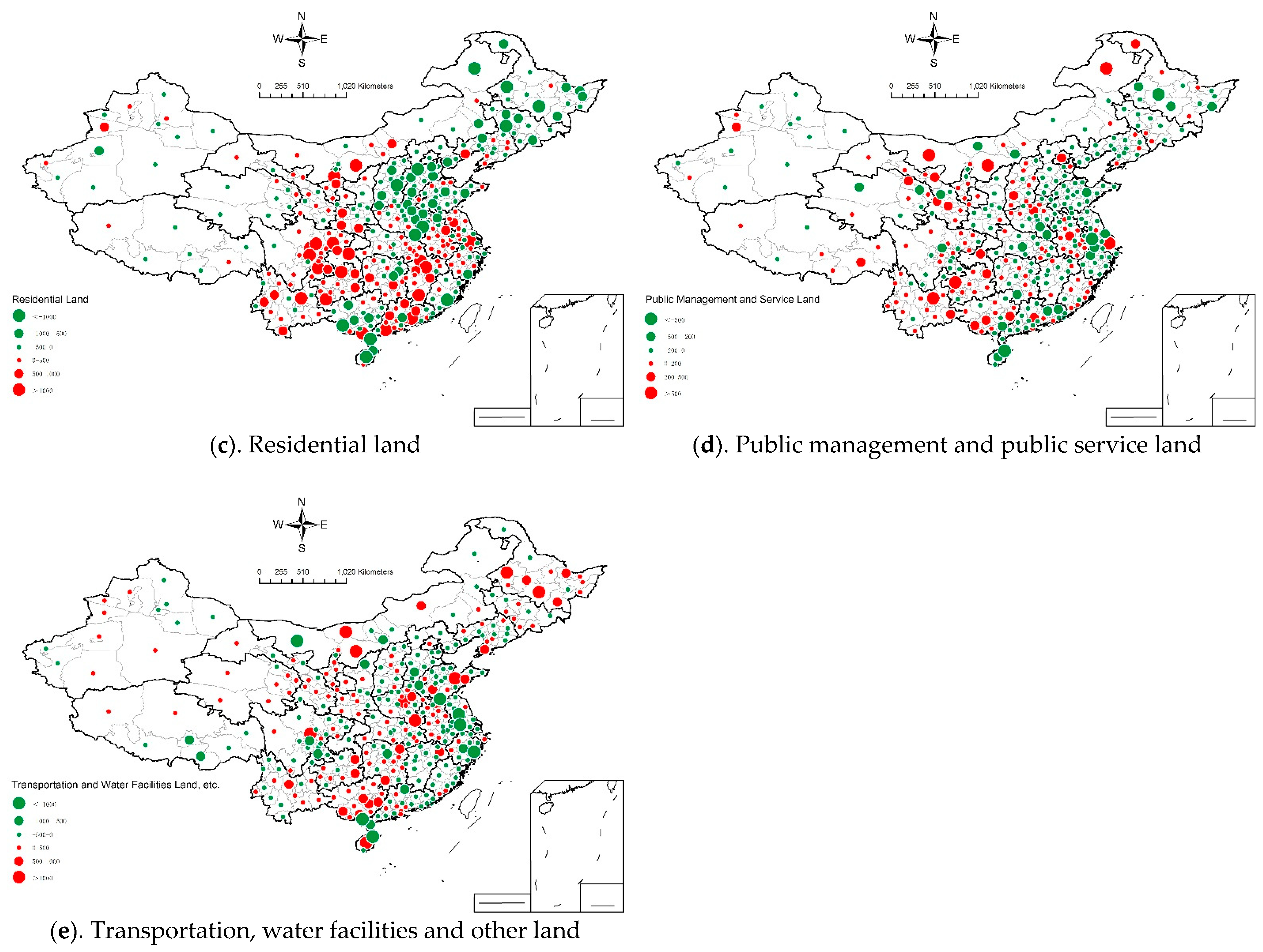
4.3. Spatial Patterns of Urban Land Use Structure Changes in Small Towns

This study uses OpenGeoDa analysis software to measure the global Moran’s I index of total urban land area per town and five types of urban land per town, including commercial service land, industrial, mining and storage land, residential land, public management and public service land, and other land, to analyze the overall spatial pattern characteristics of urban land and its structure in small towns in China (Table 4). The test reveals that the global Moran’s I index of the total urban land area and five types of urban land area in small towns in 2009 and 2013 both pass the significance test, indicating that the urban land use in small towns shows positive spatial autocorrelation. In general, the global Moran’s I indexes for all types of urban land and total urban land decreased except for transportation, water facilities, and other land, which indicates a decrease in spatial autocorrelation. However, the changes in the global Moran’s I values of all land uses except residential land use are small, suggesting that the spatial pattern of urban land use and its structure in small towns is relatively stable and has not changed significantly.
This study further analyzed the local spatial autocorrelation for each type of urban land and obtained the local autocorrelation map of five types of urban land in small towns in China (Figure 4). Commercial service land and industrial, mining and storage land exhibit similar local spatial autocorrelation characteristics and are mainly High-High cluster areas. The High-High cluster areas are primarily concentrated in some regions of Inner Mongolia and the Yangtze River Delta urban agglomeration and the Pearl River Delta urban agglomeration. Residential land, public administration and public services land, and transportation, water facilities, and other land exhibit similar spatial agglomeration characteristics. The spatial agglomeration types of these three types of urban land are mainly High-High cluster and Low-Low cluster. Among them, High-High cluster areas are mainly located in some regions of Northeast China, Inner Mongolia, Xinjiang, and Yangtze River Delta and Pearl River Delta. Low-Low cluster areas are mainly distributed in central and western regions such as Chongqing, Sichuan, Guizhou, Hunan, and Hubei. These areas are generally dominated by mountains and hills, so the scale of various types of urban land is relatively small.
This study calculates the competitive offsets of different land use types in small towns in China from 2009 to 2013 through the offset share model. It draws a spatial pattern distribution map at the prefecture level (Figure 5). As shown in the figure, the competitive offsets of commercial land; industrial, mining and storage land; and residential land in small towns in the central and western regions are all at a high level. Meanwhile, negative offsets are generally observed in small towns in the eastern region. This result has two major reasons. First, China’s land supply system, which is skewed toward the central and western regions, provides space for the expansion of land in small towns in these regions. Second, China is experiencing a large-scale industrial spatial transferring process, with many eastern cities that have reached the late stage of industrialization transferring their traditional industries to the central and western regions. Given the constraints of high land rents, high labor wages, and high environmental regulations in urban areas, small towns located around cities have become the evident choice for many local governments to build industrial parks that can undertake industrial transfer due to their cost advantages, such as low-cost land and labor. Areas with a high structural offset of public administration and public service land are mostly concentrated in some regional central cities, such as Shanghai, Kunming, Hefei, Zhengzhou, and other cities. These cities attract a large inflow of population and have a rising demand for public service facility land, which, in turn, drives the rapid growth of this type of land.

5. Conclusions and Discussion

5.1. Main Conclusions

This study analyzes the spatial and temporal characteristics of urban land use structure of more than 18,000 small towns in China by using the National Urban Land Use Survey Data between 2009 and 2013. This study finds that the urban land area of small towns expanded rapidly during the research period, and its growth rate exceeded that of urban land in cities and small town population during the same period. The spatial pattern of urban land use in small towns exhibits significant regional differences. Small towns in developed coastal regions, particularly those located in global urban areas, such as the Pearl River Delta urban agglomeration, the Yangtze River Delta urban agglomeration, and the Beijing–Tianjin–Hebei urban agglomeration, have a higher urban land use scale relative to small towns in the central and western regions and other areas. However, the land scale of small towns located in less developed inland areas has grown faster. The spatial distribution of urban stock land in small towns is primarily reflected by demographic and socio-economic factors, while the growth of urban land is largely influenced by the land supply policy tilted toward the central and western regions. In terms of structure, the proportion of production and living land in small towns is high, whereas the proportion of public services and facilities land is low. This finding suggests that in the context of early industrialization, urban land use in small towns is biased toward rigid needs, such as production and living, with insufficient attention to higher quality of life. Notably, the urban land use structure of small towns, which is dominated by productive land use, is being strengthened, with commercial service land and industrial, mining, and storage land becoming the major drivers for the rapid rise of urban land use in small towns.

5.2. Discussion

A large sample analysis of the urban land use structure of all small towns in China found that the proportion of industrial, mining and storage land, and commercial service land in small towns exceeds that of city areas, and this trend is increasing. This finding differs from previous studies on the urban land use structure of small towns in individual regions [29]. On the one hand, this result reflects the advantage of the data used in this study and reveals the general characteristics and patterns of the urban land use structure of small towns in China. On the other hand, it poses a hidden danger for the future long-term development of small towns. It has been noted that amenities have become an increasingly important factor influencing the location of businesses and innovative talents [64,65]. Public service and facility sites are the main carrier spaces for these amenities. The proportion of public service and facility land should be increased in the future to attract talents to gather in small towns, so as to achieve the long-term sustainable development of small towns.
To achieve the optimization and coordinated development of urban land use structure in small towns in China, small towns should further integrate into the surrounding large cities in the urbanization process. Due to the small scale, it is difficult for small towns to form large and comprehensive urban functions. Therefore, the development of small towns should closely surround the neighboring big cities and complement them in terms of functional configuration. Accordingly, the land use structure should also be arranged in such a way as to incorporate the needs of large cities, forming various types of characteristic towns around them.
In addition, land supply policy should be further adjusted. The central government’s land supply policy is tilted toward the central and western regions to support the development of less developed regions. However, it affects the competitiveness of the eastern regions and the overall efficiency of resource allocation. The central government has proposed to “build an urban pattern of coordinated development of large, medium-sized, and small cities and small towns with urban agglomerations as the main body,” and the allocation of construction land quotas should be consistent with the policy direction and the demand of socioeconomic development. Only when the market plays a decisive role in the allocation of land resources can the government play a better role.

Author Contributions

Conceptualization, Y.Y.; methodology, Y.Y. and Y.L.; software, Y.Y. and Y.L.; validation, Y.Y. and Y.L.; formal analysis, Y.Y. and Y.L.; data curation, Y.Y. and Y.L.; writing—original draft preparation, Y.Y., Y.S. and J.G.; writing—review and editing, Y.Y.; visualization, Y.L.; supervision, Y.Y. and Y.S.; project administration, Y.Y.; funding acquisition, Y.Y. and Y.S. All authors have read and agreed to the published version of the manuscript.

Funding

This research was supported by the National Social Science Fund of China (18BTJ019), the General Project of Social Science of Beijing Municipal Education Commission (SM201810038012), and the Fundamental Research Funds for the Capital University of Economics and Business (QNTD202009).

Institutional Review Board Statement

Not applicable.

Informed Consent Statement

Not applicable.

Data Availability Statement

Not applicable.

Conflicts of Interest

The authors declare no conflict of interest.

References

  1. Luo, J.; Zhang, X.; Wu, Y.; Shen, J.; Shen, L.; Xing, X. Urban land expansion and the floating population in China: For production or for living? Cities 2018, 74, 219–228. [Google Scholar] [CrossRef]
  2. Sun, Y.; Zhao, S. Spatiotemporal dynamics of urban expansion in 13 cities across the Jing-Jin-Ji Urban Agglomeration from 1978 to 2015. Ecol. Indic. 2018, 87, 302–313. [Google Scholar] [CrossRef]
  3. Zhang, L.; Zhang, L.; Xu, Y.; Zhou, P.; Yeh, C.H. Evaluating urban land use efficiency with interacting criteria: An empirical study of cities in Jiangsu China. Land Use Policy 2020, 90, 104292. [Google Scholar] [CrossRef]
  4. Luo, X.; Lu, X.; Jin, G.; Wan, Q.; Zhou, M. Optimization of urban land-use structure in China’s rapidly developing regions with eco-environmental constraints. Phys. Chem. Earth Parts A/B/C 2019, 110, 8–13. [Google Scholar] [CrossRef]
  5. Wang, S.; Wang, J.; Liu, X. How do urban spatial structures evolution in the high-speed rail era? Case study of Yangtze River Delta, China. Habitat Int. 2019, 93, 102051. [Google Scholar] [CrossRef]
  6. Song, X.; Feng, Q.; Xia, F.; Li, X.; Scheffran, J. Impacts of changing urban land-use structure on sustainable city growth in China: A population-density dynamics perspective. Habitat Int. 2021, 107, 102296. [Google Scholar] [CrossRef]
  7. Xiao, J.; Shen, Y.; Ge, J.; Tateishi, R.; Tang, C.; Liang, Y.; Huang, Z. Evaluating urban expansion and land use change in Shijiazhuang, China, by using GIS and remote sensing. Landsc. Urban Plan. 2004, 75, 69–80. [Google Scholar] [CrossRef]
  8. Zhao, S.; Zhou, D.; Zhu, C.; Sun, Y.; Wu, W.; Liu, S. Spatial and temporal dimensions of urban expansion in China. Environ. Sci. Technol. 2015, 49, 9600–9609. [Google Scholar] [CrossRef] [PubMed]
  9. Zhang, Z.; Liu, F.; Zhao, X.; Wang, X.; Shi, L.; Xu, J.; Yu, S.; Wen, Q.; Zuo, L.; Yi, L.; et al. Urban expansion in China based on remote sensing technology: A review. Chin. Geogr. Sci. 2018, 28, 727–743. [Google Scholar] [CrossRef] [Green Version]
  10. Feng, J.; Chen, Y. Spatiotemporal evolution of urban form and land-use structure in Hangzhou, China: Evidence from fractals. Environ. Plan. B Plan. Des. 2010, 37, 838–856. [Google Scholar] [CrossRef]
  11. Chen, W.; Zeng, J.; Li, N. Change in land-use structure due to urbanisation in China. J. Clean. Prod. 2021, 321, 128986. [Google Scholar] [CrossRef]
  12. Li, C.; Wu, K.; Wu, J. Urban land use change and its socio-economic driving forces in China: A case study in Beijing, Tianjin and Hebei region. Environ. Dev. Sustain. 2018, 20, 1405–1419. [Google Scholar] [CrossRef]
  13. Fu, Y.; Zhou, T.; Yao, Y.; Qiu, A.; Wei, F.; Liu, J.; Liu, T. Evaluating efficiency and order of urban land use structure: An empirical study of cities in Jiangsu, China. J. Clean. Prod. 2021, 283, 124638. [Google Scholar] [CrossRef]
  14. Jiao, L.; Xu, Z.; Xu, G.; Zhao, R.; Liu, J.; Wang, W. Assessment of urban land use efficiency in China: A perspective of scaling law. Habitat Int. 2020, 99, 102172. [Google Scholar] [CrossRef]
  15. Liu, S.; Xiao, W.; Li, L.; Ye, Y.; Song, X. Urban land use efficiency and improvement potential in China: A stochastic frontier analysis. Land Use Policy 2020, 99, 105046. [Google Scholar] [CrossRef]
  16. Liu, J.; Hou, X.; Wang, Z.; Shen, Y. Study the effect of industrial structure optimization on urban land-use efficiency in China. Land Use Policy 2021, 105, 105390. [Google Scholar] [CrossRef]
  17. Cao, G.; Shi, Q.; Liu, T. An integrated model of urban spatial structure: Insights from the distribution of floor area ratio in a Chinese city. Appl. Geogr. 2016, 75, 116–126. [Google Scholar] [CrossRef] [Green Version]
  18. Guastella, G.; Pareglio, S.; Sckokai, P. A spatial econometric analysis of land use efficiency in large and small municipalities. Land Use Policy 2017, 63, 288–297. [Google Scholar] [CrossRef] [Green Version]
  19. Yu, J.; Zhou, K.; Yang, S. Land use efficiency and influencing factors of urban agglomerations in China. Land Use Policy 2019, 88, 104143. [Google Scholar] [CrossRef]
  20. Tang, Y.; Mason, R.J.; Wang, Y. Governments’ functions in the process of integrated consolidation and allocation of rural–urban construction land in China. J. Rural. Stud. 2015, 42, 43–51. [Google Scholar] [CrossRef]
  21. Li, Z.; Luan, W.; Zhang, Z.; Su, M. Relationship between urban construction land expansion and population/economic growth in Liaoning Province, China. Land Use Policy 2020, 99, 105022. [Google Scholar] [CrossRef]
  22. Agyemang, F.S.; Silva, E.; Poku-Boansi, M. Understanding the urban spatial structure of Sub-Saharan African cities using the case of urban development patterns of a Ghanaian city-region. Habitat Int. 2019, 85, 21–33. [Google Scholar] [CrossRef]
  23. Wang, J.; Qu, S.; Peng, K.; Feng, Y. Quantifying urban sprawl and its driving forces in China. Discret. Dyn. Nat. Soc. 2019, 2019, 2606950. [Google Scholar] [CrossRef]
  24. Han, S.S. Urban expansion in contemporary China: What can we learn from a small town? Land Use Policy 2010, 27, 780–787. [Google Scholar] [CrossRef]
  25. Zhou, Q.; Shi, W. How does town planning affect urban-rural income inequality: Evidence from China with simultaneous equation analysis. Landsc. Urban Plan. 2022, 221, 104380. [Google Scholar] [CrossRef]
  26. Parish, W.L.; Kirkby, R.J.R. Urbanization in China: Town and Country in a Developing Economy 1949-2000 AD. Popul. Dev. Rev. 1987, 13, 154. [Google Scholar] [CrossRef]
  27. Xie, S.; Zhang, W.; Zhao, Y.; Tong, D. Extracting Land Use Change Patterns of Rural Town Settlements with Sequence Alignment Method. Land 2022, 11, 313. [Google Scholar] [CrossRef]
  28. Liu, T.; Liu, H.; Qi, Y. Construction land expansion and cultivated land protection in urbanizing China: Insights from national land surveys, 1996–2006. Habitat Int. 2015, 46, 13–22. [Google Scholar] [CrossRef]
  29. Zhou, H. Research on the intensive use of land in small towns. Acad. Exch. 2018, 11, 112–118. (In Chinese) [Google Scholar]
  30. Zhao, P.; Lyu, D. Characteristics of land use structure in small towns of china: Empirical evidences from 121 townships. Acta Geogr. Sin. 2019, 74, 1011–1024. (In Chinese) [Google Scholar] [CrossRef]
  31. Qian, Z. Resettlement and adaptation in China’s small town urbanization: Evidence from the villagers’ perspective. Habitat Int. 2017, 67, 33–43. [Google Scholar] [CrossRef]
  32. Huang, A.; Xu, Y.; Liu, C.; Lu, L.; Zhang, Y.; Sun, P.; Zhou, G.; Du, T.; Xiang, Y. Simulated town expansion under ecological constraints: A case study of Zhangbei County, Heibei Province, China. Habitat Int. 2019, 91, 101986. [Google Scholar] [CrossRef]
  33. Sun, Z.; Huang, Y.; Wan, D.; Cai, X.Y. Analysis of the Driving Mechanism of the Land Use Evolution of Small Industrial Towns: Songya Town, Mianyang City, Sichuan Province as an Example. Mod. Urban Res. 2021, 11, 106–114. (In Chinese) [Google Scholar] [CrossRef]
  34. Zou, Y.; Zhao, W. Searching for a new dynamic of industrialization and urbanization: Anatomy of China’s characteristic town program. Urban Geogr. 2018, 39, 1060–1069. [Google Scholar] [CrossRef]
  35. Shu, B.; Zhang, H.; Li, Y.; Qu, Y.; Chen, L. Spatiotemporal variation analysis of driving forces of urban land spatial expansion using logistic regression: A case study of port towns in Taicang City, China. Habitat Int. 2014, 43, 181–190. [Google Scholar] [CrossRef]
  36. Li, H.; Wei, Y.D.; Liao, F.H.; Huang, Z. Administrative hierarchy and urban land expansion in transitional China. Appl. Geogr. 2015, 56, 177–186. [Google Scholar] [CrossRef]
  37. Zhang, L.; Yue, W.; Liu, Y.; Fan, P.; Wei, Y.D. Suburban industrial land development in transitional China: Spatial restructuring and determinants. Cities 2018, 78, 96–107. [Google Scholar] [CrossRef]
  38. Zhou, Y.; Ma, L.J. Economic restructuring and suburbanization in China. Urban Geogr. 2000, 21, 205–236. [Google Scholar] [CrossRef]
  39. Fang, X.; Tang, G.; Li, B.; Han, R. Spatial and temporal variations of ecosystem service values in relation to land use pattern in the Loess Plateau of China at town scale. PLoS ONE 2014, 9, e110745. [Google Scholar] [CrossRef] [Green Version]
  40. Szarek-Iwaniuk, P.K. Changes and correlations in land-use structure within the administrative boundaries of a town–a case study. Acta Sci. Pol. Adm. Locorum 2020, 19, 61–68. [Google Scholar] [CrossRef]
  41. Xia, M.; Zhang, Y.; Zhang, Z.; Liu, J.; Ou, W.; Zou, W. Modeling agricultural land use change in a rapid urbanizing town: Linking the decisions of government, peasant households and enterprises. Land Use Policy 2020, 90, 104266. [Google Scholar] [CrossRef]
  42. Han, D.; Qiao, J.; Zhu, Q. Rural-spatial restructuring promoted by land-use transitions: A case study of Zhulin Town in central China. Land 2021, 10, 234. [Google Scholar] [CrossRef]
  43. Li, Y. Urban–rural interaction patterns and dynamic land use: Implications for urban–rural integration in China. Reg. Environ. Change 2012, 12, 803–812. [Google Scholar] [CrossRef]
  44. Zhou, Y.; Li, X.; Liu, Y. Land use change and driving factors in rural China during the period 1995–2015. Land Use Policy 2020, 99, 105048. [Google Scholar] [CrossRef]
  45. Li, J.; Jiao, H. Analysis of the land-use and structure efficiency in Lujiang county Anhui province. Territ. Nat. Resour. Stuty 2004, 3, 37–38. (In Chinese) [Google Scholar] [CrossRef]
  46. Huang, J.; Cheng, G. Evolution characteristics and transformation strategy of land use of industrial towns in northern Shaanxi. Ind. Constr. 2020, 50, 47–54. (In Chinese) [Google Scholar] [CrossRef]
  47. Yan, Y.; Cui, Z. Implementation of a small-town master plan based on land use change in the north of Jiangsu. J. Nanjing For. Univ. 2020, 44, 191–198. (In Chinese) [Google Scholar] [CrossRef]
  48. Liu, Y.; Yang, R.; Long, H.; Gao, J.; Wang, J. Implications of land-use change in rural China: A case study of Yucheng, Shandong province. Land Use Policy 2014, 40, 111–118. [Google Scholar] [CrossRef]
  49. Ye, C.; Chen, M.; Chen, R.; Guo, Z. Multi-scalar separations: Land use and production of space in Xianlin, a university town in Nanjing, China. Habitat Int. 2014, 42, 264–272. [Google Scholar] [CrossRef]
  50. Chen, M.; Wu, C. Analysis of land use problems in small towns in China and its countermeasures. Chin. Rural. Econ. 2002, 4, 15–21. (In Chinese) [Google Scholar]
  51. Yan, Z.; Lu, R. On shannon entropy of changing land use structure and sustainable use in small towns—A case study of Beiliu city in Guangxi. J. Guangxi Teach. Educ. Univ. 2008, 25, 70–74. (In Chinese) [Google Scholar] [CrossRef]
  52. Dong, Z.; Xiang, Q.; Wang, M.; Wei, X. Multi-objective land use optimization for small and medium-sized towns. J. HeFei Univ. Technol. 2022, 45, 376–382. (In Chinese) [Google Scholar] [CrossRef]
  53. Song, Y.; Zhu, D.; Yeung, G.; Xu, Y.; Zhang, L. Spatio-temporal evolution and driving mechanism of urban land use structure with the context of urban shrinkage: Evidence from Northeast China. Geogr. Res. 2021, 40, 1387–1403. (In Chinese) [Google Scholar] [CrossRef]
  54. Kyakuno, T. Quantitative representation of distribution and mixture of urban land use through spatial autocorrelation and information entropy. J. Asian Archit. Build. Eng. 2008, 7, 427–434. [Google Scholar] [CrossRef]
  55. Fan, C.; Wang, Z. Spatiotemporal characterization of land cover impacts on urban warming: A spatial autocorrelation approach. Remote Sens. 2020, 12, 1631. [Google Scholar] [CrossRef]
  56. Anselin, L. Local indicators of spatial association—LISA. Geogr. Anal. 1995, 27, 93–115. [Google Scholar] [CrossRef]
  57. Dong, L.; Li, X. Evolution of Urban Construction Land Structure Based on Information Entropy and Shift-Share Model: An Empirical Study on Beijing-Tianjin-Hebei Urban Agglomeration in China. Sustainability 2022, 14, 1244. [Google Scholar] [CrossRef]
  58. Knudsen, D.C. Shift-share analysis: Further examination of models for the description of economic change. Socio-Econ. Plan. Sci. 2000, 34, 177–198. [Google Scholar] [CrossRef]
  59. Wu, Y. The controversy and definition of the concept of small towns in China. Dev. Small Cities Towns 2014, 6, 50–55. (In Chinese) [Google Scholar]
  60. Atkinson, R. The Small Towns conundrum: What do we do about them? Reg. Stat. 2019, 9, 3–19. [Google Scholar] [CrossRef]
  61. Caselli, B.; Ventura, P.; Zazzi, M. Performance-based spatial monitoring. An interpretative model for long-term shrinking medium-small Italian towns. Sustain. Cities Soc. 2020, 53, 101924. [Google Scholar] [CrossRef]
  62. Luo, Z.; He, H. Study on development characteristics and trends of small towns in the global city-region: A case study on Yangtze river delta. City Plan. Rev. 2013, 37, 9–16. (In Chinese) [Google Scholar]
  63. Lu, M.; Zhang, H.; Liang, W. How the bias toward Central/Western land supplies boosts wages in the East. Soc. Sci. China 2015, 5, 59–83. (In Chinese) [Google Scholar]
  64. Deller, S.C.; Lledo, V.; Marcouiller, D.W. Modeling regional economic growth with a focus on amenities. Rev. Urban Reg. Dev. Stud. J. Appl. Reg. Sci. Conf. 2008, 20, 1–21. [Google Scholar] [CrossRef]
  65. Wang, C.; Wu, J. Natural amenities, increasing returns and urban development. J. Econ. Geogr. 2011, 11, 687–707. [Google Scholar] [CrossRef]
Figure 1. Spatial distribution of small towns in China.
Land 11 01262 g001
Figure 2. Average urban land area of small towns in China, 2009 (a) and 2013 (b) (unit: hectare).
Land 11 01262 g002
Figure 3. Average growth rate of the urban land area of small towns in China, 2009–2013.
Land 11 01262 g003
Figure 4. Local spatial cluster of urban land use in small towns in China.
Land 11 01262 g004aLand 11 01262 g004b
Figure 5. Spatial distribution of competitive offsets in the land use structure of small towns (unit: hectare).
Land 11 01262 g005aLand 11 01262 g005b
Table 1. Number of small towns by urban land area.
YearUrban Land Area (km2)<0.20.2–0.50.5–11–22–5>5
2009Number256343964354316022331429
Proportion14.13%24.24%24.01%17.42%12.31%7.88%
2013Number210440934367337024471754
Proportion11.60%22.57%24.08%18.58%13.49%9.67%
Table 2. Regional differences in the average urban land area and growth rate of small towns in China.
RegionAverage Land Area (km2)Growth Rate
20092013
Four RegionsEastern Region2.18 2.40 10.40%
Central Region1.47 1.73 17.15%
Western Region1.27 1.59 24.63%
Northeast Region1.92 2.06 7.38%
Urban agglomerationsYangtze River Delta2.61 3.00 15.12%
Pearl River Delta4.53 5.15 13.67%
Beijing–Tianjin–Hebei2.02 2.18 7.97%
Other Regions1.49 1.75 17.48%
Table 3. Comparison of urban land use structure and changes between small towns and city areas in China, 2009–2013.
Total LandCommercial Service LandIndustrial, Mining and Storage landResidential LandPublic Administration and Public Service LandTransportation LandSpecial Use LandWater and Water Facilities LandOther Land
Small townsArea (km2)200937,2912319957512,972455142932776352669
201344,039302012,58515,058515649882897002243
ChangeArea (km2)6748701301020866056951265−426
Percentage (%)18.1030.2331.4416.0813.2916.194.3310.24−15.96
Structure (%)20091006.2225.6834.7912.2011.510.741.707.16
20131006.8628.5834.1911.7111.330.661.595.09
Change 0.642.90−0.59−0.50−0.19−0.09−0.11−2.06
City areasArea (km2)200935,3272280873811,038520049146336211903
201339,649279210,42212,660556653466286631572
ChangeArea (km2)432251216841622366432−542−331
Percentage (%)12.2322.4619.2714.697.048.79−0.796.76−17.39
Structure (%)20091006.4524.7331.2514.7213.911.791.765.39
20131007.0426.2931.9314.0413.481.581.673.96
Change 0.591.550.68−0.68−0.43−0.21−0.09−1.42
Table 4. Global spatial autocorrelation analysis of urban land use of small towns in China.
Land-Use Type20092013
Moran’s IZ
Values
P
Values
Moran’s IZ
Values
p
Values
Total urban land0.22712.6970.0000.21411.9270.000
Commercial service land0.1528.6760.0000.1407.9090.000
Industrial, mining and storage land0.20711.9680.0000.19111.0730.000
Residential land0.30116.3810.0000.22312.2020.000
Public management and public service land0.1297.4910.0000.1277.2880.000
Transportation, water facilities, and other land0.1729.6500.0000.22512.4690.000
Publisher’s Note: MDPI stays neutral with regard to jurisdictional claims in published maps and institutional affiliations.

