
Perspectives of Post-Industrial Towns and Landscape in Eastern Slovakia—Case Study Strážske


Abstract
: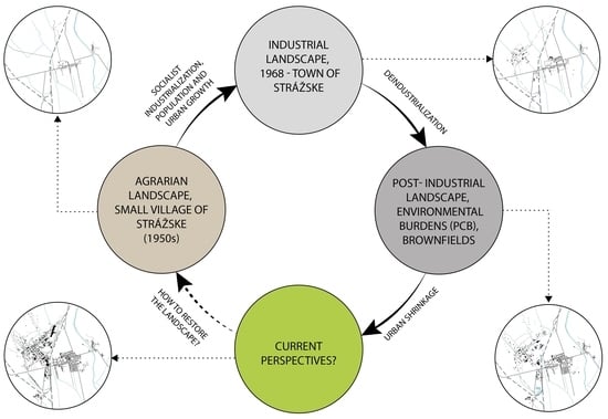
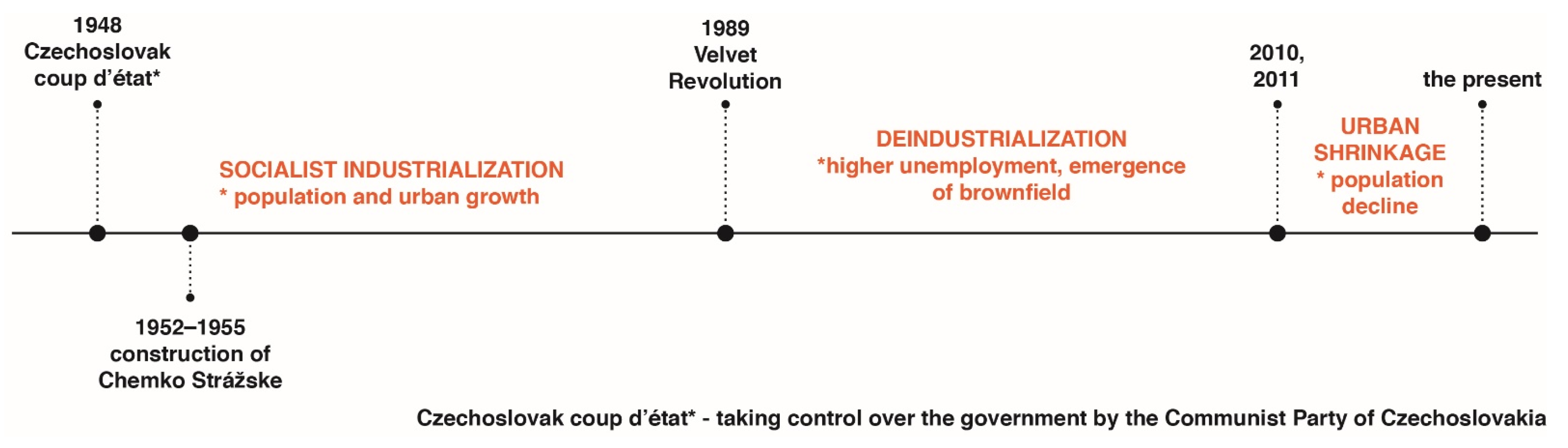
1. Introduction
- Socialist industrialisation determined the spatial development of cities and the reconstruction of the original urban structure;
- Determined the transformation of agrarian landscape into industrial.
- The emergence of brownfields;
- Urban shrinkage;
- The landscape became post-industrial and revealed problems with environmental burdens.
2. Materials and Methods
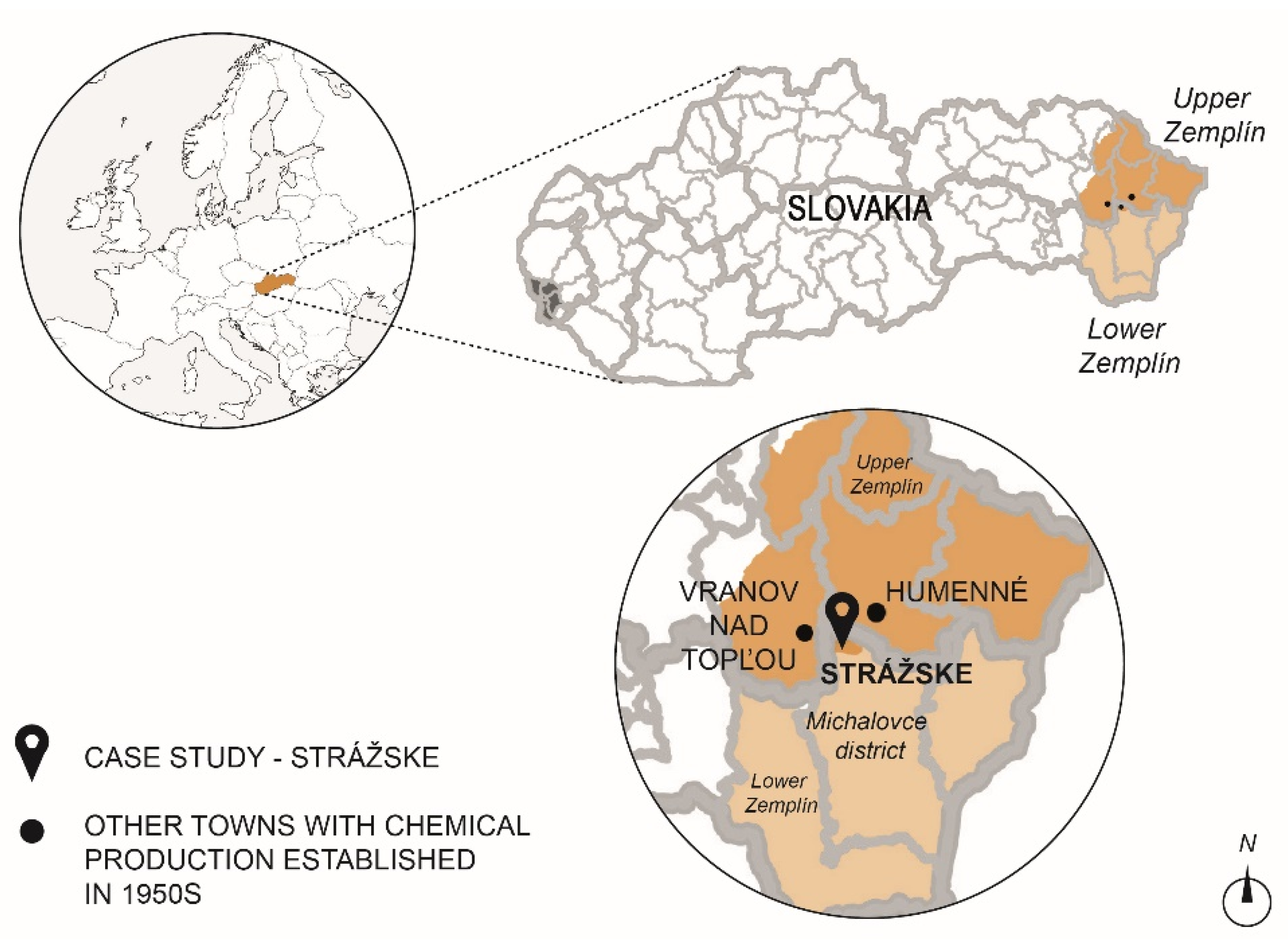
2.1. The Study Area
- Industrial areas make up the greater part of the built-up area of the town;
- High number of industrial brownfields;
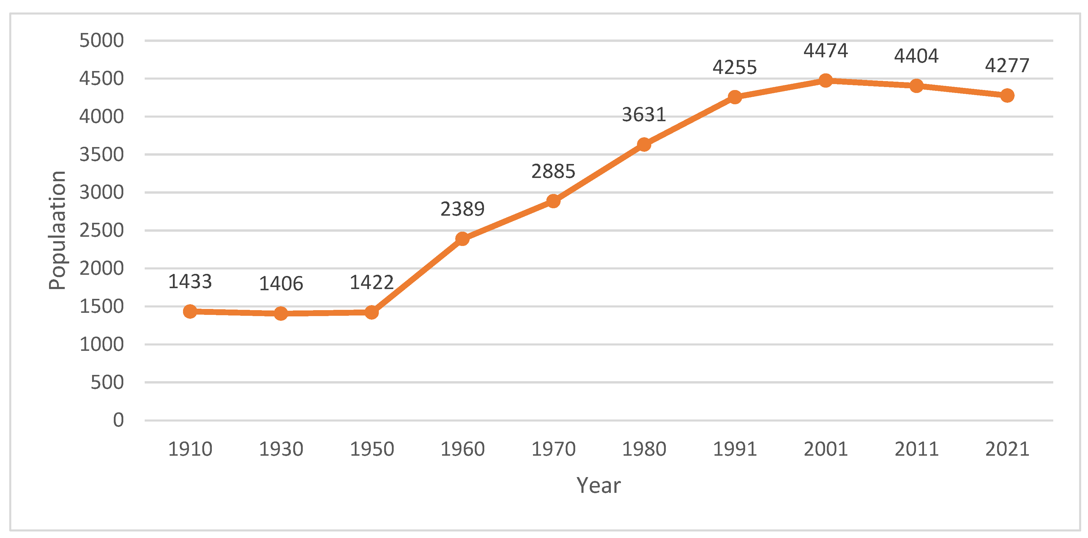
- Population decline [20];
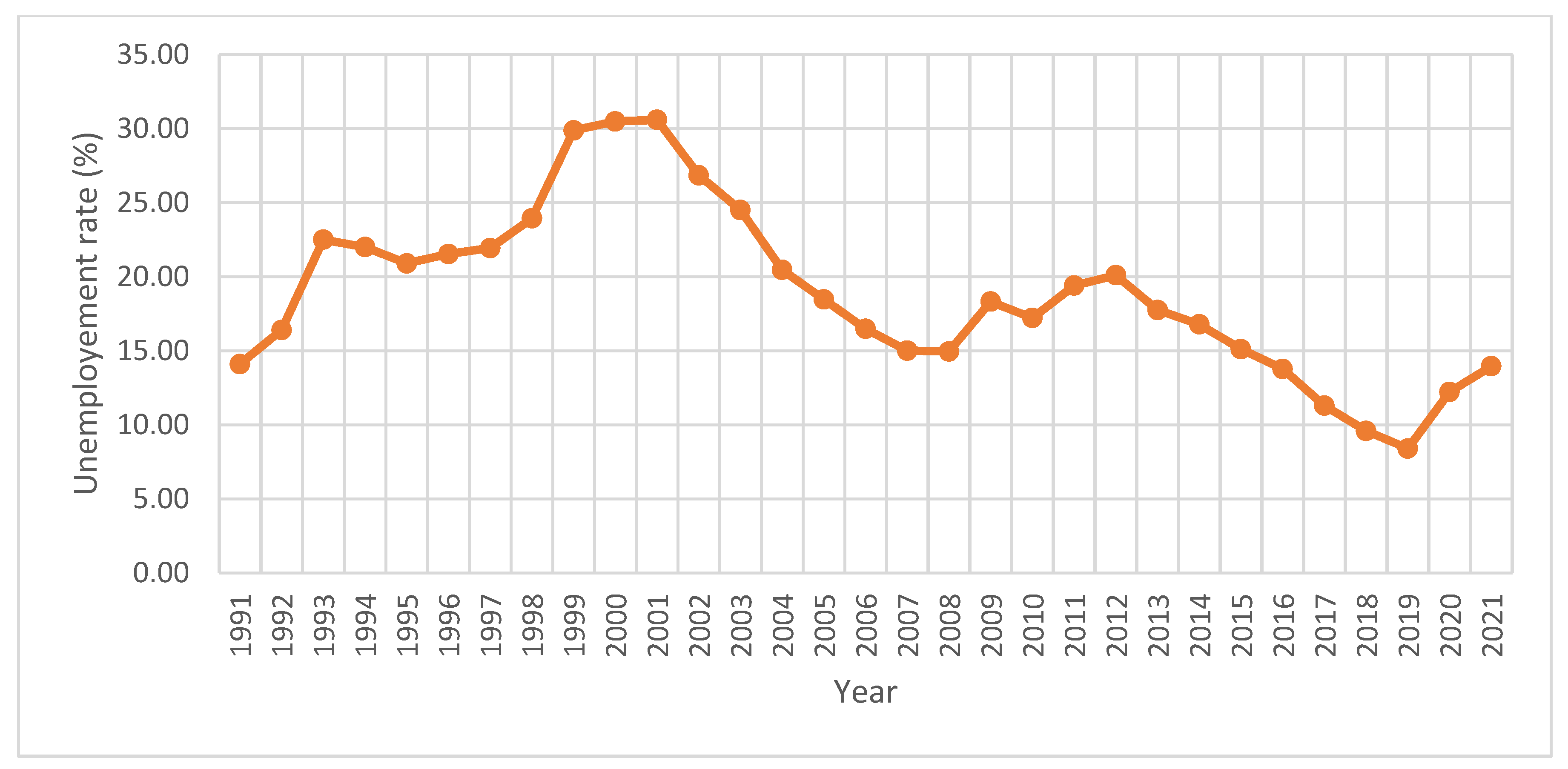
- Region with low competitiveness [44];
- The mass redundancies of 75 Chemka employees in March this year and the imminent bankruptcy [46];
- The environmental burden of the Poša sludge bed, where waste products were discharged from Chemko [47];
- The highest concentration of PCB pollution in Europe is in the Michalovce district [47].
2.2. Research Methods and Data
- Urban development and assessment of the impacts of socialist industrialisation and deindustrialisation on the urban structure and landscape;
- The suggestion of strategies to create a sustainable and resilient shrinking town of Strážske. The suggestion of strategies to address the brownfield issue while creating the resilient shrinking towns of Strážske.
2.2.1. The First Stage of Research—Method
- Potentially contaminated site (A)
- Contaminated site (B)
- Remediated, reclaimed site (C)
- Contaminated site excluded from registers (D).
2.2.2. The Second Stage of Research—Method
3. Results
3.1. The First Stage of Results
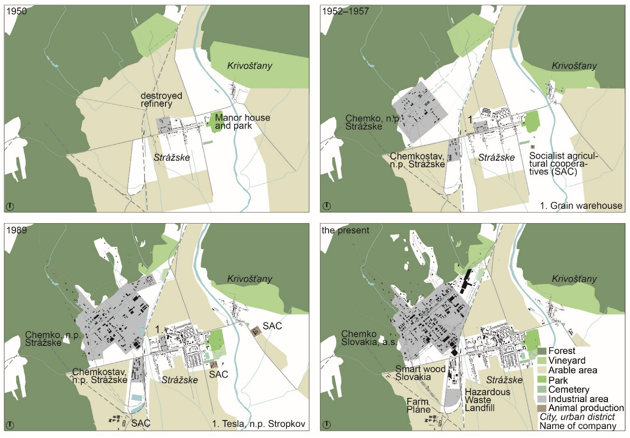
3.1.1. Strážske and Its Urban Development
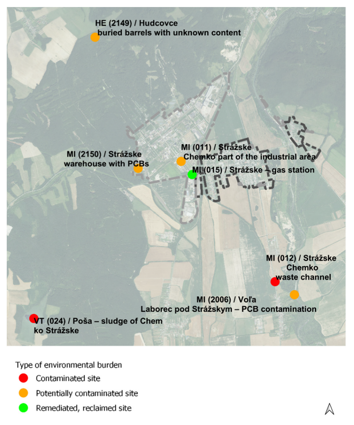
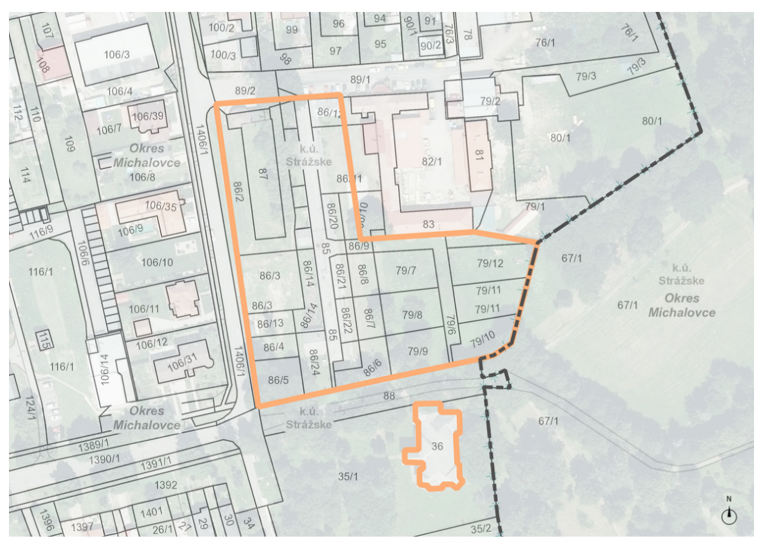
3.1.2. Environmental Burdens in Strážske
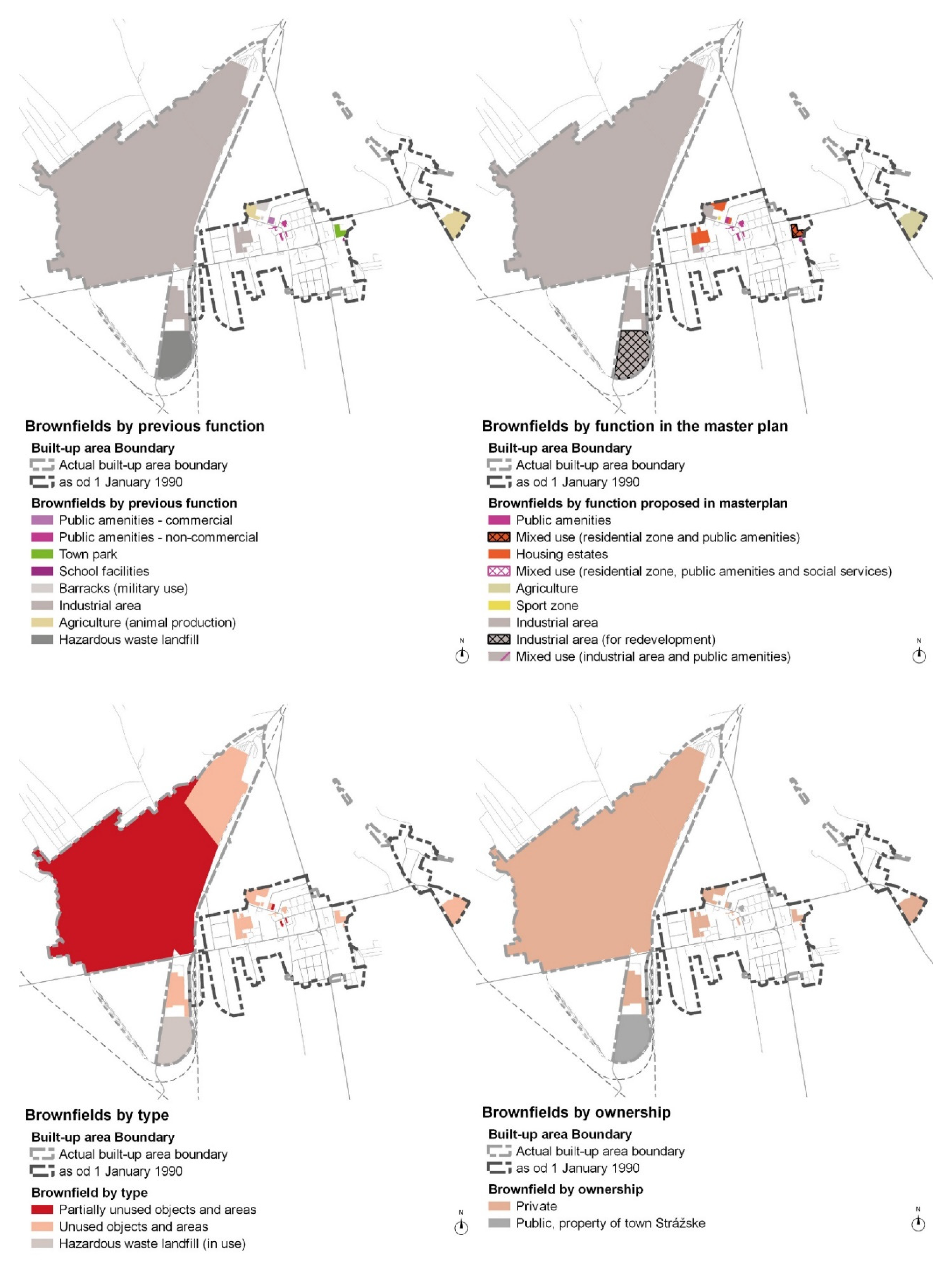
3.1.3. Brownfields in Strážske
3.2. The Second Stage of Results
Strategies for a Sustainable and Resilient Shrinking Town Strážske
- The layout pattern (Figure 8) confirms the location dependence with the town area of proposed solutions.
- Temporary functions and transformation (C, D) of function are concentrated in the town centre, implying the importance of re-densification and accessibility of such functions.
- Demolition and green areas (A, B) are concentrated at the outer edge of the built-up area implying that the shrinking of the built-up area closer to the period before rapid development is possible, as well as the importance of incorporating the green spaces in town.
4. Discussion
5. Conclusions
Author Contributions
Funding
Institutional Review Board Statement
Informed Consent Statement
Data Availability Statement
Conflicts of Interest
References
- Tsenkova, S.; Nedović-Budić, Z. (Eds.) The Urban Mosaic of Post-Socialist Europe: Space, Institutions and Policy; Physica: Heidelberg, Germany, 2006; pp. 3–20. ISBN 978-3-7908-1726-3. [Google Scholar]
- Sýkora, L. Post-Socialist Cities. In International Encyclopedia of Human Geography; Kitchin, R., Thrift, N., Eds.; Elsevier: Oxford, UK, 2009; Volume 8, pp. 387–395. ISBN 978-0-08-044910-4. [Google Scholar]
- Haase, A.; Bernt, M.; Grossmann, K.; Mykhnenko, V.; Rink, D. Varieties of Shrinkage in European Cities. Eur. Urban Reg. Stud. 2013, 12, 1–17. [Google Scholar] [CrossRef]
- Stanilov, K. (Ed.) The Post-Socialist City; Springer: Dordrecht, The Netherlands, 2007; pp. 3–15. ISBN 978-1-4020-6052-6. [Google Scholar]
- Hamilton, F.E.I.; Dimitrowska-Andrews, K.; Pichler-Milanovic, N. (Eds.) Transformation of Cities in Central and Eastern Europe: Towards Globalisation; United Nations University Press: Tokyo, Japan, 2005; pp. 3–21. ISBN 9280811053. [Google Scholar]
- Sýkora, L.; Bouzarovski, S. Multiple Transformations: Conceptualising the Post-communist Urban transition. Urban Stud. 2012, 49, 43–60. [Google Scholar] [CrossRef] [Green Version]
- Bontje, M. Facing the Challenge of Shrinking Cities in East Germany: The Case of Leipzig. GeoJournal 2004, 61, 13–21. [Google Scholar] [CrossRef]
- Stryjakiewicz, T. The Process of Urban Shrinkage and its Consequences. Rom. J. Reg. Sci. 2013, 7, 29–40. [Google Scholar]
- Hirt, S. Whatever happened to the (post)socialist city? Cities 2013, 32, 29–38. [Google Scholar] [CrossRef]
- Londák, M. Otázky Industrializácie Slovenska (1945–1960); Veda: Bratislava, Slovakia, 1999; pp. 7–52. ISBN 978-80-224-0570-1. [Google Scholar]
- Petrosjan, K.A. Sovětký Způsob Industrialisace; Svoboda: Prague, Czech Republic, 1952. [Google Scholar]
- Markovič, J. Chemko Národný Podnik Strážske: Nositeľ Vyznamenania Za Zásluhy o Výstavbu: 1952–1977; Východoslovenské vydavateľstvo: Košice, Slovakia, 1977; pp. 13–15. [Google Scholar]
- Adam, J. Dejiny Strážskeho; Excel Enterprise: Michalovce, Slovakia, 2008; ISBN 978-80-89258-25-3. [Google Scholar]
- Fedič, V.; Adam, J.; Belej, M.; Bodnárová, M.; Hraboský, P.; Kónya, P.; Meričko, J.; Michnovič, I.; Rosič, M.; Strakošová, I.; et al. Dejiny Humenného; Vasil FEDIČ—REDOS: Humenné, Slovakia, 2002; pp. 45–301. ISBN 80-968790-4-9. [Google Scholar]
- Michnovič, I. Vranov nad Topľou v 20. storočí. Časť druhá: 1948–2000; PRINTON: Vranov nad Topľou, Slovakia, 2005; pp. 49–77; 198. ISBN 80-969263-2-2. [Google Scholar]
- Komanický, V.; Olexa, J. Chemlon Národný Podnik Humenné; Východoslovenské vydavateľstvo: Košice, Slovakia, 1978; pp. 15–16. [Google Scholar]
- Jevín, M. BUKÓZA Národný Podnik VRANOV nad TOPĽOU; Východoslovenské vydavateľstvo: Košice, Slovakia, 1976; pp. 53–81. [Google Scholar]
- Drotár, M.; Grmolcová, G. Chemko Národný Podnik Strážske 1952–1982. Nositeľ Radu Práce; Východoslovenské vydavateľstvo: Košice, Slovakia, 1982; p. 13. [Google Scholar]
- Baláž, V. Od montažnej dielne k inteligentnej ekonomike. In Odkiaľ a Kam. 20 Rokov Samostatnosti; Meseznikov, G., Bútoróvá, Z., Kollár, M., Eds.; Kalligram/IVO: Bratislava, Slovakia, 2013; pp. 566–581. [Google Scholar]
- Hajduková, R.; Sopirová, A. Brownfields and Green Infrastructure in the Region of “Triangle of Death”. In Proceedings of the DOCONF/2021 Facing Post-Socialist Urban Heritage, Budapest, Hungary, 8–9 October 2021; pp. 182–193. [Google Scholar]
- Novotný, L.; Csachová, S.; Kulla, M.; Nestorová-Dická, J.; Pregi, L. Development trajectories of small towns in east Slovakia. Eur. Countrys. 2016, 4, 373–394. [Google Scholar] [CrossRef] [Green Version]
- Frantál, B.; Kunc, J.; Nováková, E.; Klusáček, P.; Martinát, S.; Osman, R. Location matters! Exploring brownfields regeneration in a spatial context (case study of the South Moravian Region, Czech Republic). Morav. Geogr. Rep. 2013, 21, 5–19. [Google Scholar] [CrossRef]
- Skála, J.; Vácha, R.; Čechmánková, J.; Horváthová, V. Various aspects of the genesis and perspectives on agricultural brownfields in the Czech Republic. Morav. Geogr. Rep. 2013, 21, 46–55. [Google Scholar] [CrossRef] [Green Version]
- Hercik, J.; Šimáček, P.; Szczyrba, Z.; Smolová, I. Military brownfields in the Czech Republic and the potential for their revitalisation, focused on their residential function. Quaest. Geogr. 2014, 33, 127–138. [Google Scholar] [CrossRef] [Green Version]
- Kunc, J.; Navrátil, J.; Tonev, P.; Frantál, B.; Klusáček, P.; Martinát, S.; Havlíček, M.; Černík, J. Perception of urban renewal: Reflexions and coherences of socio-spatial patterns (Brno, Czech Republic). Geogr. Tech. 2014, 9, 66–77. [Google Scholar]
- Rieniets, T. Shrinking cities: Causes and effects of urban population losses in the twentieth century. Nat. Cult. 2009, 4, 231–254. [Google Scholar] [CrossRef]
- Klingholz, R. Europe’s Real Demographic Challenge. Policy Rev. 2009, 157, 61–70. [Google Scholar]
- Hollander, J.B.; Pallagst, M.K.; Schwarz, T.; Popper, F.J. Planning shrinking cities. Prog. Plan. 2009, 72, 2–36. [Google Scholar]
- Allen, C.R.; Birge, H.E.; Bartelt-Hunt, S.; Bevans, R.A.; Burnett, J.L.; Cosens, B.A.; Cai, X.; Garmestani, A.S.; Linkov, I.; Scott, E.A.; et al. Avoiding Decline: Fostering Resilience and Sustainability in Midsize Cities. Sustainability 2016, 8, 844. [Google Scholar] [CrossRef] [Green Version]
- Herrmann, D.L.; Shuster, W.D.; Mayer, A.L.; Garmestani, A.S. Sustainability for Shrinking Cities. Sustainability 2016, 8, 911. [Google Scholar] [CrossRef] [Green Version]
- Rumpel, P.; Slach, O. Shrinking cities in central Europe. In Transitions in Regional Science—Regions in Transition: Regional research in Central Europe; Herrschel, T., Dostál, P., Raška, P., Koutský, J., Eds.; Wolters Kluwer: Prague, Czech Republic, 2014; Volume 1, pp. 142–155. ISBN 978-80-747-8560-3. [Google Scholar]
- Pavolová, H.; Bakalár, T.; Emhemed, E.M.A.; Hajduová, Z.; Pafčo, M. Model of sustainable regional development with implementation of brownfield areas. Entrep. Sustain. Issues 2019, 6, 1088–1100. [Google Scholar] [CrossRef] [Green Version]
- Nassauer, J.I.; Raskin, J. Urban vacancy and land use legacies: A frontier for urban ecological research, design, and planning. Landsc. Urban Plan. 2014, 125, 245–253. [Google Scholar] [CrossRef]
- Haase, D.; Dushkova, D.; Haase, A.; Kronenberg, J. Green infrastructure in post- socialist cities. Evidence and experiences from Eastern Germany, Poland and Russia. In Post-Socialist Urban Infrastructures; Tuvikene, T., Sgibnev, W., Neugebauer, C.S., Eds.; Routledge: London, UK, 2019; Volume 1, pp. 105–124. ISBN 978-08-153-9265-1. [Google Scholar]
- Schetke, S.; Haase, D. Multi-criteria assessment of socio-environmental aspects in cities. Experiences from eastern Germany. Environ. Impact Assess. Rev. 2008, 28, 483–503. [Google Scholar] [CrossRef]
- Stubbs, M. Natural green space and planning policy: Devising a model for its delivery in regional spatial strategies. Landsc. Res. 2008, 33, 119–139. [Google Scholar] [CrossRef]
- Atkinson, G.; Doick, K.J.; Burningham, K.; France, C. Brownfield regeneration to greenspace: Delivery of project objectives for social and environmental gain. Urban For. Urban Green. 2014, 13, 586–594. [Google Scholar] [CrossRef]
- Rink, D.; Schmidt, C. Afforestation of Urban Brownfields as a Nature-Based Solution. Experiences from a Project in Leipzig (Germany). Land 2021, 10, 893. [Google Scholar] [CrossRef]
- IBA Emscher Park. Available online: https://www.internationale-bauausstellungen.de/en/history/1989-1999-iba-emscher-park-a-future-for-an-industrial-region/ (accessed on 15 May 2022).
- Winkelhardt, R. Logistické Areály Automobilového Prumyslu a Krajina- Vlivy a Plánovací Nástroje. Ph.D. Thesis, Czech Technical University, Prague, Czech Republic, 2011. [Google Scholar]
- Oliver, L.; Ferber, U.; Grimski, D.; Millar, K.; Nathanail, P. The scale and nature of European brownfields. In Proceedings of the CABERNET 2005—International Conference, Belfast, Northern Ireland, UK, 13–15 August 2005; Available online: http://www.cabernet.org.uk/resourcefs/417.pdf (accessed on 12 April 2022).
- Djukić, A.; Vujičić, T.M.; Antonić, B. Greening as an Approach for Urban Renewal of Shrinking Cities. In Proceedings of the ICUP2018 2nd International Conference on Urban Planning, Nis, Serbia, 14–17 November 2018; pp. 291–297. [Google Scholar]
- Osman, R.; Frantál, B.; Klusáček, P.; Kunc, J.; Martinát, S. Factors affecting brownfield regeneration in post-socialist space: Thecase of the Czech Republic. Land Use Policy 2015, 48, 309–316. [Google Scholar] [CrossRef]
- Concept of Spatial Development of Slovakia 2001, as Amended by CSDS 2011. Available online: https://www.mindop.sk/ministerstvo-1/vystavba-5/uzemne-planovanie/dokumenty/uplne-znenie-kurs2001-v-zneni-kurs2011 (accessed on 10 January 2022).
- DATAcube. Stastical Office of the Slovak Republic. Available online: http://datacube.statistics.sk/#!/lang/en/?utm_source=susr_portalHP&utm_medium=page_database&utm_campaign=DATAcube_portalHP (accessed on 20 January 2022).
- TASR. Chemko Slovakia Hromadne Prepúšťa. Zamestnanci sú už Niekoľko Mesiacov bez Výplat. Available online: https://www.forbes.sk/chemko-slovakia-hromadne-prepusta-zamestnanci-su-uz-niekolko-mesiacov-bez-vyplat/ (accessed on 13 April 2022).
- Overview of PCB Monitoring and Its Results in the Zemplín Region for the Purposes of the Project: Program to Demonstrate the Viability and Removal of Barriersmthat Impede Adoption and Successful Implementation of Available, Non-Combustion Technologies for Destroying Persistent Organic Pollutants (POPs). Available online: https://inis.iaea.org/collection/NCLCollectionStore/_Public/39/050/39050645.pdf (accessed on 15 April 2022).
- Chemko.sk. Company Profile. Available online: https://www.chemko.sk/en/company-profile (accessed on 13 April 2022).
- Turza, R. Francúzski Paličkári Pomôžu Zmierniť pád Chemka. Do Novej Fabriky Investujú Milióny a Zamestnajú Stovku ľudí. Available online: https://hnonline.sk/finweb/ekonomika/96017754-francuzski-palickari-pomozu-zmiernit-pad-chemka-do-novej-fabriky-investuju-miliony-a-zamestnaju-stovku-ludi?fbclid=IwAR3pVFyQUCUwONvrfcxYYc7OMB407RlV-He3f06YYtdBQWtYZgLpVhz5o58 (accessed on 13 April 2022).
- Hinse, T. The Morphology of Times: European Cities and their Historical Growth; DOM Publishers: Berlin, Germany, 2014; ISBN 978-3-86922-309-4. [Google Scholar]
- Enviroportal. List of Environmental Burdens—Information System of Contaminated Sites. Available online: https://envirozataze.enviroportal.sk/ (accessed on 8 May 2022).
- Kropf, K. The Handbook of Urban Morphology; John Wiley & Sons Ltd.: Chichester, UK, 2017; ISBN 978-11-187-4771-1. [Google Scholar]
- Real Estate Cadastre. Available online: https://zbgis.skgeodesy.sk/mkzbgis/sk/kataster?bm=zbgis&z=13&c=21.830270,48.875354&sc=n&pos=48.800000,19.530000,8 (accessed on 12 May 2022).
- Business Register of MoJ SR. Available online: https://www.orsr.sk/default.asp?lan=en (accessed on 12 May 2022).
- Vision and Strategy for the Development of Slovakia within the Year 2030—Long-Term Sustainable Strategy Development of the Slovak Republic—Slovakia 2030. Available online: https://www.mirri.gov.sk/wp-content/uploads/2021/01/Slovensko-2030.pdf (accessed on 1 July 2022).
- TASR. V Strážskom Začali s Likvidáciou Sudov s PCB. Available online: https://www.enviroportal.sk/clanok/v-strazskom-zacali-s-likvidaciou-sudov-s-pcb (accessed on 24 May 2022).
- Pre PCB látky po Chemku Strážske je Vyhlásená Mimoriadna Situácia na Východe Slovenska. Available online: https://www.minv.sk/?tlacove-spravy&sprava=pre-pcb-latky-po-chemku-strazske-je-vyhlasena-mimoriadna-situacia-na-vychode-slovenska (accessed on 24 May 2022).
- Nemec, M. Nemecký Magnát Kúpil Skrachované Oceliarne. Available online: https://hnonline.sk/hnbiznis/2173976-nemecky-magnat-kupil-skrachovane-oceliarne (accessed on 24 May 2022).
- Czechinvest, Database of Brownfields. Available online: http://www.brownfieldy.eu/en/database-of-brownfields/ (accessed on 24 May 2022).
- Finka, M.; Petríková, D.; Zúbková, M.; Jamečný, Ľ. Analýza Prekážok v Zhodnocovaní Nevyužívaných a Zanedbaných Uzemí v Intraviláne Miest a Návrh Podporných Opatrení; SPECTRA Centre of Excellence: Bratislava, Slovakia, 2019; Available online: https://www.mindop.sk/ministerstvo-1/mestsky-rozvoj-6/mestsky-rozvoj/studie (accessed on 24 May 2022).
- SARIO Database. Available online: http://db.sario.sk/ (accessed on 24 May 2022).
- Detection of Status and Barriers for Revitalization of Unused and Neglected Areas in Built-Up Areas of Cities in Slovakia. Available online: https://www.mindop.sk/uploads/SBPMR/Mestsk%C3%BD%20rozvoj/Zistovanie%20stavu%20a%20barier%20zhodnocovania%20nevyuzivanych%20a%20zanedbanych%20uzemi_vyhodnotenie%20prieskumu.pdf (accessed on 1 July 2022).
- Moravčíková, H.; Szalay, P. The Trade Union House/Istropolis: The Birth and Liquidation of an Innovative Generator of Social Life, Culture, and Education. Archit. Urban. 2021, 3–4, 123–145. [Google Scholar] [CrossRef]
- Sidorová, M. Nepredať! Zveľadiť! Nadácia Cvernovka: Bratislava, Slovakia, 2020; ISBN 978-80-973690-0-2. [Google Scholar]
- Moravčíková, H.; Szalay, P.; Haberlandová, K.; Krišteková, L.; Bočková, M. Bratislava (Ne)Plánované Mesto; SLOVART: Bratislava, Slovakia, 2020; ISBN 978-80-556-4696-1. [Google Scholar]
- Gregorová, B.; Hronček, P.; Tometzová, D.; Molokáč, M.; Čech, V. Transforming Brownfields as Tourism Destinations and Their Sustainability on the Example of Slovakia. Sustainability 2020, 12, 10569. [Google Scholar] [CrossRef]
- Bihuňová, M.; Takáčová, A.; Verešová, M. Analyses of the brownfields use in the Nitra city and its surrounding. Plants Urban Areas Landsc. 2014, 155–158. [Google Scholar] [CrossRef]
- Pavolová, H.; Kyseľová, K.; Bakalár, T. Brownfields as a tool for support of Destination Tourism development. Acta Geoturistica 2012, 3, 26–30. Available online: https://geotur.tuke.sk/pdf/2012/n01/04_Pavolova_v3_n1.pdf (accessed on 24 May 2022).
- Hronček, P.; Gregorová, B.; Tometzová, D.; Molokáč, M.; Hvizdák, L. Modeling of Vanished Historic Mining Landscape Features as a Part of Digital Cultural Heritage and Possibilities of Its Use in Mining Tourism (Case Study: Gelnica Town, Slovakia). Resources 2020, 9, 43. [Google Scholar] [CrossRef]
- Kristiánová, K. Strategies for tourism enhancement in Danube towns—Green infrastructure approach. Plants Urban Areas Landsc. 2018, 14–18. [Google Scholar] [CrossRef]
- Kádár, B.; Vitková, Ľ. Sustainability options for tourism development. In Book on the Unexplored Cultural Heritage in Communities by the Danube, 1st ed.; Benko, M., Pavel, G., Vitková, Ľ., Eds.; Gasset: Prague, Czech Republic, 2021; pp. 88–95. ISBN 978-80-87079-63-8. [Google Scholar]
- Kristiánová, K.; Gécová, K.; Putrová, E. Old Industrial Sites—Conversion to Parks: Potential of Bratislava. Procedia Eng. 2016, 161, 1858–1862. [Google Scholar] [CrossRef] [Green Version]
- Chochrunova, N. River and brownfields as axes for urban regeneration—Case study Martin, Slovakia. In Proceedings of the International Multidisciplinary Scientific GeoConference: SGEM, Sofia, Bulgaria, 2–8 July 2018. [Google Scholar]


| Map | Data Availability | Source |
|---|---|---|
| Historical orthophoto map of Slovakia | 1950 | Centre of Excellence for Forest and Landscape Decision Support, TU Zvolen |
| Military topographic map 1:25,000 1st edition | 1952–1957 | National Geoportal of Slovakia, Historical Mapping |
| Base map 1:25,000 | 1989 | Institute of Geodesy and Cartography Bratislava, Archive, Basic maps |
| Orthophoto mosaics of Slovakia | the present | Institute of Geodesy and Cartography Bratislava, Cadastre, Orthophoto |
| Scenario | Suitable | Unsuitable |
|---|---|---|
| A | Unsatisfactory construction and technical condition of buildings | Objects of high cultural and historical value |
| Building structures unsuitable for further use, for example, degraded by chemical production | Objects aspiring to declare Historic Landmark, etc. | |
| Contamination remediation | ||
| independent of location within the town | ||
| B | May or may not be partially green areas | Creation of any type of gardens on contaminated brownfields and implementation of urban agriculture |
| Especially suitable for contaminated brownfields | ||
| independent of location within the town | ||
| C | Creation of a temporary function (flexible, low costs for its creation and maintenance) | Heavily contaminated areas that have not yet been remediated |
| Contamination remediation | ||
| location within the city centre suitable for possible re-densification of urban structure | ||
| D | Objects of high cultural and historical value | Unsatisfactory construction and technical condition of buildings |
| Objects aspiring to declare Historic Landmark, etc. | Building structures unsuitable for further use, for example, degraded by chemical production | |
| The building has good construction and technical condition and it is suitable for transformation | ||
| independent of location within the town |
| Cadastral Area | Identifier | Type of Environmental Burden | Last Actualisation | Priority | Specification of Environmental Burden |
|---|---|---|---|---|---|
| Hudcovce | SK/EZ/HE/2149 | Potentially contaminated site | August 2020 | - | HE (2149)/Hudcovce—buried barrels with unknown content |
| Poša | SK/EZ/VT/1030 | Contaminated site | March 2022 | medium | VT (024)/Poša—sludge bed of Chemko Strážske |
| Strážske | SK/EZ/MI/1344 | Remediated, reclaimed site | March 2017 | not specified | MI (015)/Strážske—gas station |
| Strážske | SK/EZ/MI/493 | Potentially contaminated site | July 2016 | - | MI (011)/Strážske—Chemko part of the industrial area |
| Strážske | SK/EZ/MI/494 | Contaminated site | January 2022 | high | MI (012)/Strážske—Chemko—waste channel |
| Strážske | SK/EZ/MI/2150 | Potentially contaminated site | August 2020 | - | MI (2150)/Strážske—warehouse with PCBs |
| Voľa | SK/EZ/MI/2006 | Potentially contaminated site | January 2015 | - | MI (2006)/Voľa—Laborec pod Strážskym—PCB contamination |
| Key Factor | Challenges | Potential |
|---|---|---|
| Locality (position within Slovakia) | Location outside the economic centre and main Transport routes in Slovakia | Brownfields can be the catalyst for regional development |
| Previous function | Risk of pollution | Continuing with previous function (e.g., existing infrastructure) |
| Environmental burdens | Barrier in further redevelopment | Green infrastructure development and establishment of new biotopes |
| Limitation of future functional use | ||
| Expensive remediation | ||
| Ownership structure | Barrier in further redevelopment | Opportunity to revitalise city property for public good |
| Function proposed by master plan | Development-oriented (does not reflect current needs) | Ability to form the vision of sustainable urban development |
| Destruction of cultural values (manor house demolition) | ||
| Urban sprawl (development on previously undeveloped sites) |
Publisher’s Note: MDPI stays neutral with regard to jurisdictional claims in published maps and institutional affiliations. |
© 2022 by the authors. Licensee MDPI, Basel, Switzerland. This article is an open access article distributed under the terms and conditions of the Creative Commons Attribution (CC BY) license (https://creativecommons.org/licenses/by/4.0/).
Share and Cite
Hajduková, R.; Sopirová, A. Perspectives of Post-Industrial Towns and Landscape in Eastern Slovakia—Case Study Strážske. Land 2022, 11, 1114. https://doi.org/10.3390/land11071114
Hajduková R, Sopirová A. Perspectives of Post-Industrial Towns and Landscape in Eastern Slovakia—Case Study Strážske. Land. 2022; 11(7):1114. https://doi.org/10.3390/land11071114
Chicago/Turabian StyleHajduková, Romana, and Alžbeta Sopirová. 2022. "Perspectives of Post-Industrial Towns and Landscape in Eastern Slovakia—Case Study Strážske" Land 11, no. 7: 1114. https://doi.org/10.3390/land11071114