Article

The Role of Modeling Landscape Values by Harmonizing Conservation and Development Requirements

Faculty of Agriculture, University of Zagreb, 10000 Zagreb, Croatia
*
Author to whom correspondence should be addressed.
Land 2023, 12(1), 250; https://doi.org/10.3390/land12010250
Submission received: 15 November 2022 / Revised: 19 December 2022 / Accepted: 9 January 2023 / Published: 13 January 2023

Abstract

:
This paper investigated the need for the inquiry of landscape values and public participation within the decision-making process on spatial changes. They are taken into account as an important segment in the harmonization of conservation and development requirements in the planning of sustainable spatial development. The method for obtaining that information was established, and new approaches in landscape research were tested through the perception of its values as the first step to solving the conflicts between spatial conservation and development. Through the research of the experiences and theoretical knowledge on the nature protection issues within the spatial planning context, this paper indicated the need for determination of the effectiveness of the standardization approach to nature protection. Also, it emphasized the importance of testing a possible application of new approaches, which would be based on a mutually agreed approach to the protection and development of space. Modeling the landscape qualities of the space was presented as a basic tool within the presentation methodology and within the inclusion of different public segments in the spatial planning procedure. Its usefulness has been shown in the possibility of preparing the cartographic presentation of the harmonized model, which simultaneously includes the opinions of all relevant groups and can be easily implemented in the planning procedure using the GIS tools before decision-making. This paper pointed out that such an approach contributes to solving the practical problems in the protection of landscape qualities that represent public good and the link between nature and culture, and biophysical, perceptional, social, and developmental elements within the space.

1. Introduction

Development is a term that is used very often, and in Croatian, it means taking on more and more perfect, complete, and better-adapted forms for phenomena and things that are perfected over time [1]. In the spatial context, development implies achieving harmony in space and improving services to meet general social needs. However, when trying to satisfy all general needs, a problem is the excessive exploitation of resources that can lead to the loss of natural resources necessary for the life of all living beings. Because of this, the very term ‘development’ can be perceived as a negative factor in space. Still, development activities do not necessarily lead to a permanent loss of resources. The inclusion of protective interests and goals in development strategies and the harmonization of these seemingly completely opposite needs (development and protection) can contribute to the achievement of sustainable development goals.
Despite the fact that the Sustainable Development Strategy of the Republic of Croatia [2] was adopted back in 2009, a comprehensive approach to sustainable development cannot be considered based on strategic cross-sector integration [3]. Sustainable development programs are left to individual sectors, which still implement protection in the process through the objectives of preserving a certain (mostly one) primary resource. At the same time, there is no intersectoral dialogue for the joint development of strategies and programs that would enable balanced development and protection of all resources. Participatory dialogue, exchange of knowledge, and other mechanisms for including the value attitudes of different interest groups are necessary components in the decision-making process based on the principles of sustainable development. In order to achieve this, many approaches and methodologies have been developed, which often differ depending on the sectoral or professional point of view. Due to the different goals, interests, and values of individuals and social groups, it is very difficult to achieve spatial planning decisions with harmonized points of view [4].
The difference in the understanding of space and the perception of development and protection requirements of different interest groups was the impetus for this research. All sectors that directly or indirectly operate in space have an impact on the landscape and its qualities. Neither the landscape nor its qualities are permanent, and they cannot be conserved. They are interactive and constantly change due to human activity in space. This activity is mainly carried out through different ways of land use, the changes of which are defined by spatial planning documents. Land use planning is the basic human activity that creates and changes the landscape [5,6].
Landscape research is focused on the comprehensiveness of man’s understanding of the landscape, including ecological and environmental significance, as well as issues of physical and social transformation of space and environment [7]. Gobster and Xiang [8] define landscapes as visible, socio-ecological systems with changing spatial and temporal dimensions that have pronounced aesthetic, natural, and cultural qualities that people perceive and value in different ways. That is why the role and task of landscape architects are to focus attention on spatial issues and to observe, analyze and understand the processes that take place in space and shape the landscape [9].
Different professions are needed to understand the landscape as well as to harmonize social and ecological values with the aim of achieving sustainability [8]. However, different expert groups have different value starting points about space [10,11,12]. This increases the probability of them coming into conflict over the methods and results of planning the development and protection of the area. It is necessary to determine how experts from different sectors perceive landscape qualities when planning changes in space. The planning process must also be the basic mechanism for harmonizing different private and public needs and approaches [11,12]. Namely, all participatory approaches to landscape protection, management, and planning must include human perception [5]. According to Ipsen [6], landscape, or its understanding, can be a link in relation to nature and can contribute to shaping strategies for sustainable spatial development.
In the process of spatial planning, the basic incentives are obtained from the knowledge, assumptions, and requirements of experts who represent the interests of a certain sector [13,14]. The problem can then, consequently, arise due to the different valorization of the elements of space protection and sustainability. When creating sectoral strategies and programs, the preservation of primary natural resources (fertile soil, rare habitat, etc.) from potential degradation is taken into account for each sector [15]. The basic goal of such an approach is the permanent management of natural resources and long-term economic profitability, which results in the dominance of individual sectoral interests in the protection of existing and potential qualities of natural resources. Given that the sustainable use of natural resources cannot be assessed in the long term (at least not with a high degree of certainty), the protection of natural resources must be carried out through procedures for harmonizing points of view, goals, and spatial planning activities [16,17], which doesn’t happen nowadays. On the other hand, achieving sustainability in spatial planning is only possible with an approach that determines the most optimal solution among several variants [17].

2. Literature Review

The most prevalent approach to the protection of the quality of the landscape is based on the principle of standardization by pre-determining the norms and standards that will be applied regardless of the specificity of the location and/or the development needs of the area. That is why it is necessary that spatial planning decisions are the result of an optimization procedure that implies making decisions about a certain area, simultaneously including protective and development criteria. At the same time, preserved landscape qualities are a prerequisite for personal and social well-being [18]. Landscape qualities are defined by Stephenson [19], p. 300 as everything that an individual, group, or discipline considers a valuable or important aspect of that experience. Healey [20] emphasizes that the space we imagine is as important as physical objects, and therefore it is more important to include the meanings of a certain space in spatial concepts than to look for complete natural qualities. Landscape qualities are essentially a public good [21]. Planning that includes landscape qualities is aimed at connecting aesthetic, social, historical, cultural, biological, environmental, and economic issues [8,22], p. 400. They need to be determined and preserved or even improved in future planning [19]. Therefore, it is important that landscape protection measures are contained in spatial plans.
According to Marušić [23], there are three types of protective activities; (1) protection through spatial reserves, (2) environmental impact assessment, and (3) vulnerability analyses. In this paper, emphasis will be placed on the first and last type of protective activities, the first of which represents a standardization approach and the latter an optimization approach. Vulnerability analysis is considered an optimization approach because it investigates spatial and landscape qualities before adopting a solution from the aspect of potential dangers from planned activities and is therefore considered a method used in the process of searching for solutions [23]. Standardization approaches in landscape planning imply predetermined, generally accepted solutions in protection such as protected nature areas, areas in the ecological network Natura 2000, etc. [24]. The experimental area in the proposed research, the Neretva Delta, was chosen precisely because of the recent efforts of the nature protection sector to declare it a protected area in the nature park category, even though it is already part of the Natura 2000 network.
Makarow et al. [7] emphasize the need to research the conflicting value attitudes of different social communities: local residents, occasional visitors, experts, scientists, and politicians. Renn et al. [25] note that there is no ideal solution to the conflicts between legitimate demands for public participation and the need for technical and economic rationality. Involving the local population creates a sense of connection with the project, allows individuals to understand different points of view, and helps planners incorporate the wishes of the local population into their proposals [26]. This enables the resolution of spatial problems arising from conflicting interests in space, thereby achieving sustainable spatial development. However, the problem stated by Fabos [27] is that the existing landscape planning tools, such as suitability analysis, which would reduce the impacts of development by locating planned activities in suitable areas, are not used. As early as 45 years ago, Hopkins [28], in his work dealing with the analysis of methods for generating spatial suitability maps, expressed that such analyzes are a standard part of planning analyses. According to Golobič [12], suitability analyzes can be used when searching for alternative locations but also in the decision-making process in the evaluation of proposed locations and the selection of the most acceptable ones.
Society is still influenced by sectoral thinking in terms of laws, rules, planning, and administration [22]. Connecting different areas, cross-sector integration, and harmonizing interests, viewpoints, and goals in the process of spatial planning are the basis for the protection of natural resources and the achievement of sustainable spatial development [29,30,31,32]. Although Bienenfeld [33] points out that multidisciplinarity, in terms of the influence of administrative areas (sectors), is one of the basic features of spatial planning, we argue that it should still be interdisciplinarity. It implies connecting and permeating the knowledge of different areas in solving spatial problems, so it is necessary for spatial planning that aims at sustainable development. Given that the landscape is a space used by all sectors, they are also responsible for solving landscape issues [22]. Landscape studies are also multidisciplinary in nature [34]. Sustainable planning, according to Senes and Toccolini [35], requires a detailed analysis of development needs as well as the vulnerability of resources with respect to development. The process of strategic assessment of environmental plans and programs [36] was introduced with the aim of establishing a protective aspect in spatial planning. In the planning process, it is necessary to identify, simulate and harmonize sectoral development aspirations. Vulnerability analysis, as a landscape planning tool, takes into account sectoral notions of valuable areas, but at the same time, the sensitivity of the area in relation to planned development [32]. Sustainable spatial planning requires understanding and connecting models from social and physical (spatial) systems [37]. By reviewing scientific and political debates, Golobič et al. [38] establish that forms of participatory decision-making on direct space development towards sustainability by ensuring transparency, inclusion, fairness, and opportunities for judgment for all stakeholders. The authors also emphasize the high contribution of participatory decision-making to sustainability goals.
Čaldarović [39] mentions some of the ways of preserving natural resources as the basis of sustainable development: (1) the creation of development plans that will respect natural values and treat them as development potentials, (2) social assessment process to assess development options and (3) inclusion of the obtained results when creating a development plan. In the research carried out by Swor and Canter [40], it was shown that the approach used by different experts, by applying direct communication not only about specific spatial problems but also about approaches to solving them, resulted in the opening of new opportunities for improving the sustainability of an area. Renn et al. [25], in their research on public participation in decision-making, divided the public into stakeholders, experts and residents.
Making decisions related to the environment requires the integration of complex interrelationships of ecological, economic, and social aspects, and therefore, in the initial phase, the active involvement of all participants is very important because they, together with experts, can contribute to the creation of spatial scenarios [41,42,43]. The mentioned procedure can also lead to a reduction in conflicts because the values and meanings that different groups attribute to the landscape are the subjects of harmonizing different views and interests [44]. Furthermore, the creation of spatial scenarios enables verification of the possible effects of various planning decisions [45]. Gantar [46] points out that scenarios can contribute to the reduction in uncertainty and can indicate cause-and-effect relationships arising from a potential decision and thus influence planning decisions. Also, in the context of uncertainty and different values and goals, the participation of all relevant actors is important for achieving social stability [47]. Reducing the degree of uncertainty in the process of spatial planning can be achieved with a strategic approach that implies intersectoral cooperation [48] through the connection of a discursive and interactive strategic approach instead of an established institutional, sectoral one [49].
The problem is that there are still not generally accepted and effective solutions for reconciling protection goals and people’s needs [50], p. 8349. The reason for this is that Sayer et al. [50] see that people and society are left out when thinking about protection. Many authors propose a participation model for decision-making whose goal is to connect the knowledge, values, and interests of different groups of stakeholders and the preferences of the population into a procedural framework [25,51].

3. Materials and Methods
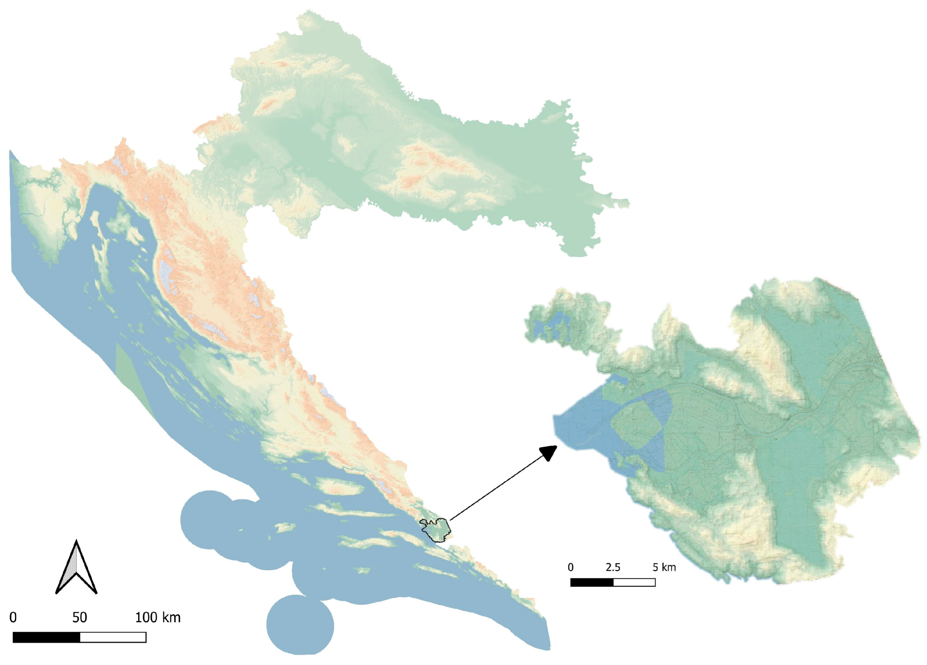
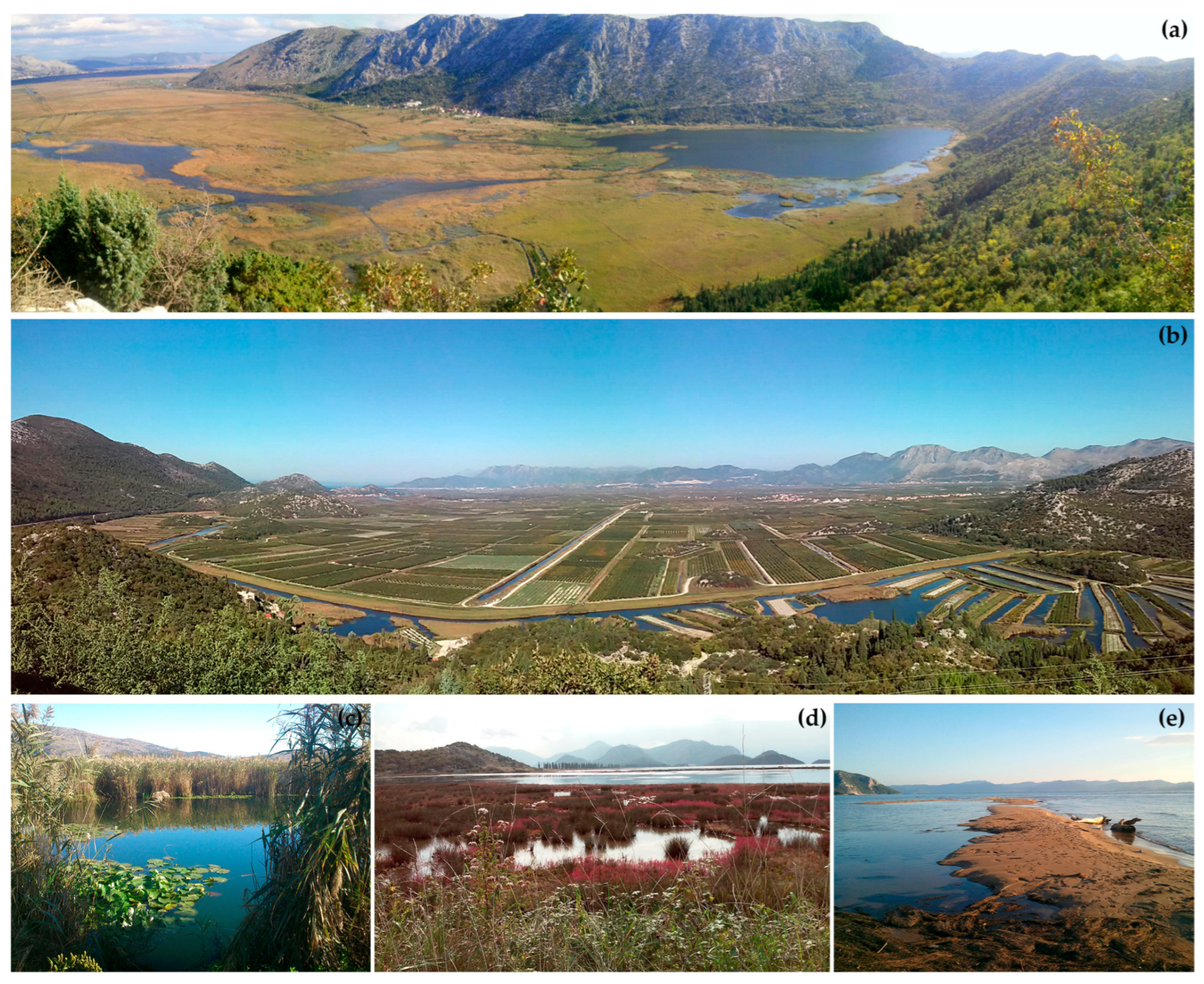
3.1. Research Area

River Neretva valley is situated in the Dubrovnik Neretva county in the very south of Croatia. It is located between the hills and the Adriatic Sea (Figure 1). It is a landscape characterized by the diversity of vegetation and ornitofauna, but also the diversity of the agricultural heritage, which was created precisely because of the natural features of this area.
The Neretva delta is the most valuable example of land reclamation in the coastal area. In 1880, for the first time, an organized attempt was made to bring them to culture. At the same time, the inhabitants developed a method of cultivating the land–harrowing–in which canals were dug by hand to drain water, and the excavated material was used to form plots for growing citrus fruits and other crops. A distinctive pattern of the trenches landscape was created, which today survives only in certain parts of the Neretva delta, in contrast to modern uniform plots (Figure 2).
The Neretva delta is a unique area of the Republic of Croatia due to its natural and social characteristics and at the same time, an area under pressure from various development aspirations (proximity to the port of Ploče, cross-border influences). That is why there is an increased probability of conflicts between different sectors regarding the methods and results of planning the development and protection of space in that area. Many authors [11,14] emphasize that when there is a change in the landscape in relation to a change in land use, technological development, and human needs, there are always disagreements between different sectors that share the same space. Ziafati Bafarasat [52] believes that conflict is the initial stage for reaching consensus or partial consensus on the legality and correctness of a decision and that the process from conflict to consensus around individual projects or changes in the area must begin already at the strategic level of decision-making when there are opportunities and space to reconcile different interests. Healey [20] sees strategic spatial planning as self-conscious joint efforts in the creation of cities, regions, and wider areas and the transfer of results into priorities for investment in space, protection measures, strategic infrastructure investments, and principles for the regulation of planning and land use.
In general, in areas such as the Neretva delta, according to Roe [26], a comprehensive approach to landscape planning was often lacking, which usually resulted in conflicts between users and, thus, in the non-inclusion of all interest groups in planning and decision-making. It is important to mention that a comprehensive approach to the landscape in research takes into account three aspects; image, structure, and activities [53] p. 15, where the image represents the perception and meaning of the landscape, the structure of the material spatiality of the landscape, and the activities the processes occurring in the landscape. Roe [26] also states that certain groups, local authorities, and stakeholders are positioned as guardians and supervisors of policy implementation and managers of activities but given that most activities end up being carried out unplanned, this leads to conflict. If that area were to be declared a nature park, measures of behavior in the area would be adopted, which would change and/or limit the possibility of the action of other sectors in the area [32]. The most important groups, according to a previously conducted sociological study, that would be affected by this declaration are farmers, hunters, and fishermen [54]. Therefore, the sectors of nature protection, agriculture, and hunting were selected as target groups of empirical research. A possible obstacle in the approach where only experts are taken into account is the possible bypassing of local knowledge about the area, which could lead to insignificant and incompetent results [11]. Research on the perception of biodiversity [55] in the area of the Channel Islands National Park in California shows that respondents with a high degree of spatial knowledge consider large inaccessible areas to be more biodiverse and natural. The reason for this is that, unlike visitors who do not know the area, they are able to compare accessible and inaccessible parts. However, taking into account the fact that active hunters as well as farmers know the area very well and have many memories related to the researched area, apart from experts, they can also be considered local residents.

3.2. Modeling as a Research Strategy

Modeling is very important in the systematic solution of spatial problems. Considering that the landscape is a complex system [56], a great effort is needed to simplify this complexity. Modeling is a research strategy based on simplification [57]. A model is an interpretation of an object, a part of space, or an organizational structure from the real world, and in this case, it represents reality, that is, simplified and generalized spatial characteristics of the real world, its individual components, its different positions, forms and relationships [58]. According to the definition [57], landscape models are spatial, although some models that are only related to the landscape—such as preference models, do not necessarily have to be.
Modeling can be used for a wide range of research—from the synthesis of descriptive information to the prediction and implementation of system actions and to the exploration of new possible relationships [57]. Also, the use of modeling in GIS contributes to the availability and comprehensibility of a large number of complex questions for the public [59]. Steinitz [60,61] also sees the formation of models and modeling as a very important element in the understanding and analysis of complex systems in space. At the same time, he emphasizes the importance of generating models in geodesign that simultaneously includes and integrates methods and concepts arising from geography, spatially oriented sciences, but also design professions such as architecture, landscape architecture, urban and spatial planning, civil engineering, etc. [61], relying on the development of information technologies.
The purpose of designing a model is the need to interpret and analyze a situation in space that does not yet exist but which can easily arise if certain conditions are met, that is, in the event that the plan is realized [62], p. 70. Knowing the possible consequences of the implementation of a plan enables checking the correctness of the decisions that led to the creation of the plan, which is extremely important in planning. Lang and Blaschke [63] see great potential in modeling as a basis for planning processes and decision-making, where certain spatial characteristics (or values) can be very easily visualized, which can be very complex and often unavailable or unnoticeable to decision-makers.
Considering that planning already, by definition, deals with the future, which is uncertain and inaccessible within the framework of knowledge, it cannot be experienced until it becomes the present [64], p. 88. Instead of facing an inaccessible future, readable systems can be studied in the form of models. That is why, according to the author, it is necessary to create theories and hypotheses about the future and then test them in such a way that they are shaped into models of the future state of a system (or space). Given that the landscape is a holistic system [65], both too large and too diverse to be directly processed, modeling is considered an appropriate approach.
As already mentioned, the model does not show a completely real object but rather its specific characteristics, functions, shapes, and states. At the same time, the selection of what the model represents in analysis is crucial for achieving the goals. Thus, a model can be a topographical or some thematic map, and it can also be an interpretation of reality—an explanation, theory, or clarification of legality. Precisely, the biggest challenge of modeling research is to determine the optimal level of simplification for a specific purpose [57]. Modeling in space is an attempt to connect the professional knowledge, values, and interests of different stakeholders into a procedural framework that enables the development of an agreed proposal for various spatial policies [25]. What is important to note is that models do not necessarily have to deal only with simulations but can also depict the effects of certain alternative interventions or activities in space [64]. Values are defined as properties or qualities sui generis (unique in their characteristics, op. trans.) of objects or objects, and states that they are not real qualities in the physical sense but that they exist and change depending on the subject’s interest in some object [66].
In its scope, the model represents a very reduced and generalized structure. Various spatial characteristics are presented in the form of matrices in such a way that evaluations are given according to certain degrees of the spatial phenomenon, according to a predetermined scale. In most cases, due to the ease of access but also the habit of using, a scale of 1 to 5, or 0–5, is used, where 0 is absolutely invulnerable, and 5 is the most vulnerable.
The type of planning that deals with networks of alternative activities instead of one must include planning models that strive for an optimal set of alternative activities when choosing. The benefit of modeling is the understanding of the system and the knowledge that the models, given the possible decisions, will indicate the consequences of those decisions and that they are not a function of a certain type of model [64]. Golobič [12] states the importance of using modeling using parameters obtained from interview analysis at all levels of planning, especially at the local level when planning land use. The basic difference between the model and the approach of social and natural sciences is in the character of the model; social models are mostly qualitative, and natural models are quantitative [37]. The authors of the research state that this does not have to be a problem because qualitative methods resulting from social research can be quantified through conversion into different forms of value scales. Hewlett et al. [67], in researching the experience of tranquility in nature-protected areas, use GIS models to compare the perception of institutions and area residents. Sandker et al. [68] conducted research on the role of participatory modeling in landscape approaches with the aim of harmonizing protection and development, in which they indicate that participatory models are not the solution to all problems in harmonizing development and protection at the landscape level, but that they can be a powerful tool that helps all stakeholders in understanding the dynamics in the landscape and which improves the process of decision-making and investments in the management of natural resources.
In multicriteria analysis carried out in GIS applications, the method of weighted linear combination prevails [69]. This method can be considered a hybrid between qualitative and quantitative methods [70,71]. Instead of exclusive quantitative optimization, the focus of this method is on the extraction of subjective values with the aim of including them in objective measurements and their deeper understanding [71].
Multicriteria analysis is a tool for value modeling and decision-making at multiple levels and at the same time, implies compromises in the selection process between variant solutions [72]. Multicriteria analysis in GIS is used to determine suitable areas for multi-purpose use [69], consulting experts and stakeholders to identify the relative importance of map layers representing different criteria [72]. It belongs to the techniques that help decision-makers when structuring multi-level decisions and evaluating variant proposals on the development or protection purpose of a certain land [71]. Malczewski [73] warns that the weighted linear combination method in decision-making can be misused, especially if it is not based on clear theoretical assumptions. Considering a large number of factors and the diversity of data sources when harmonizing different criteria in the decision-making process, Feizizadeh and Keinberger [74] emphasize the importance of uncertainty in the final results. The authors, therefore, propose the use of the AHP method [75], which reduces complexity by comparing pairs of individual criteria and thereby facilitates the ranking of variant solutions. Jiang and Eastman [76] see as a problem in the weighted linear combination that the standardized factors represent a possible suitability (that is, vulnerability or attractiveness, depending on the level of analysis); at the same time, a higher value represents a greater suitability of a location for a specific use, but without a real threshold to determine which locations can be selected and which excluded from further consideration. However, in the spirit of strategic thinking about space, which is based on harmonizing variant proposals for development and protection, such an approach, which is not exclusive, actually shows many advantages. The suitability model for locating a certain procedure does not mean that all proposed locations are ideal but guided by fuzzy logic [76], the models enable insight into the classified suitability. Still, models of suitability, vulnerability, and attractiveness obtained by the method of the weighted linear combination are not final in decision-making but only as an optimal proposal that must undergo further verification and harmonization with other interests.

3.3. Methods

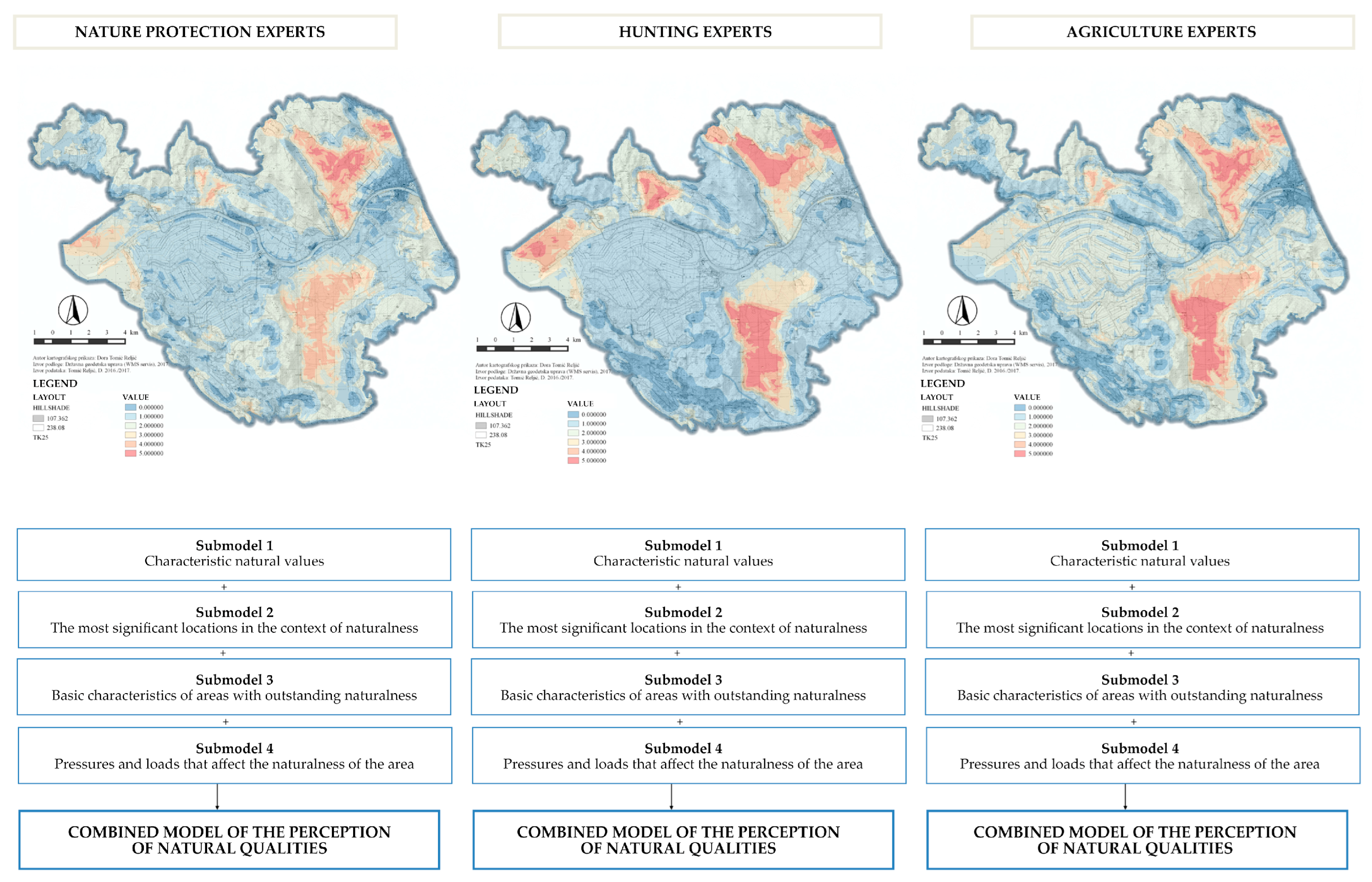
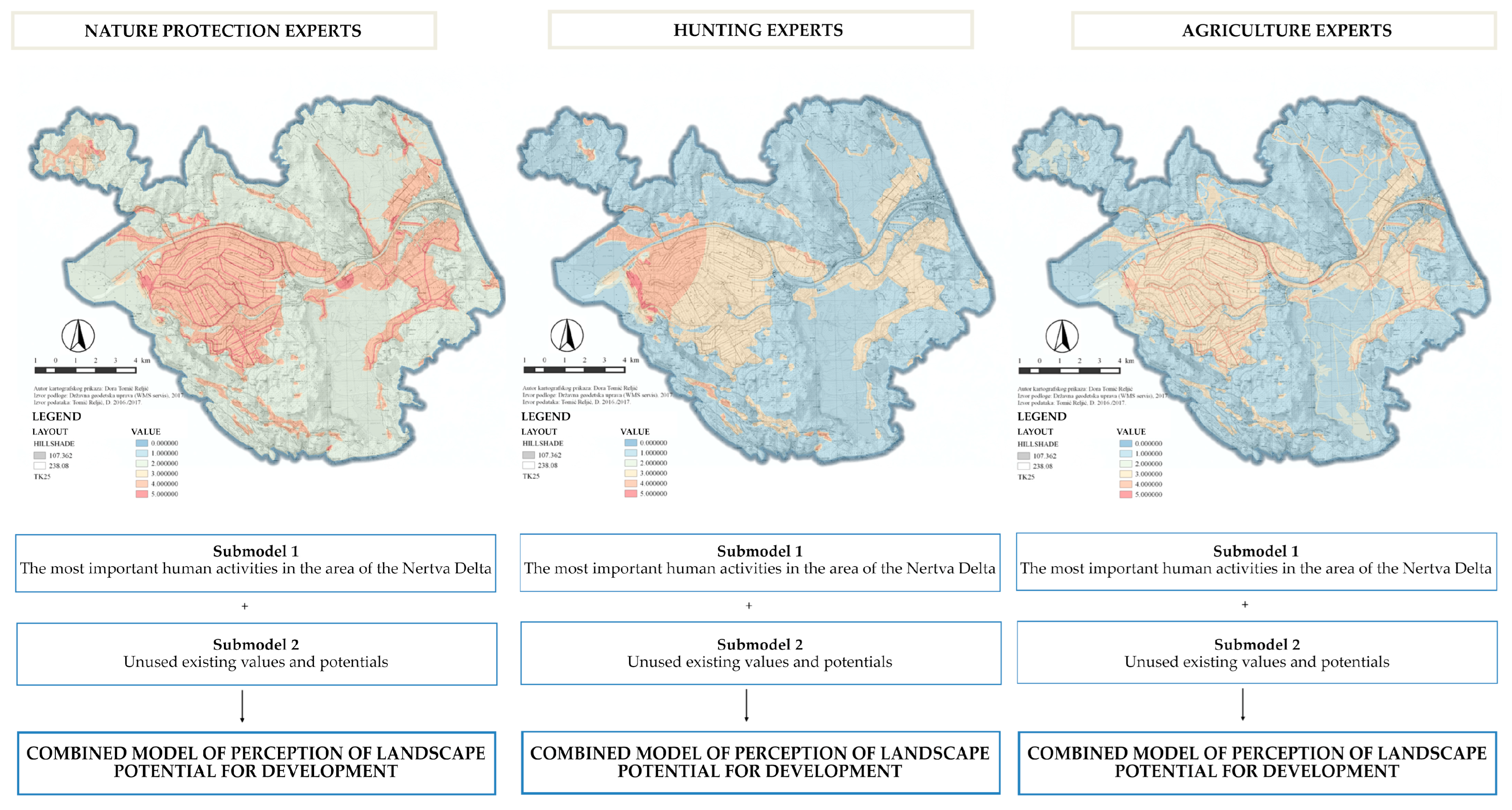
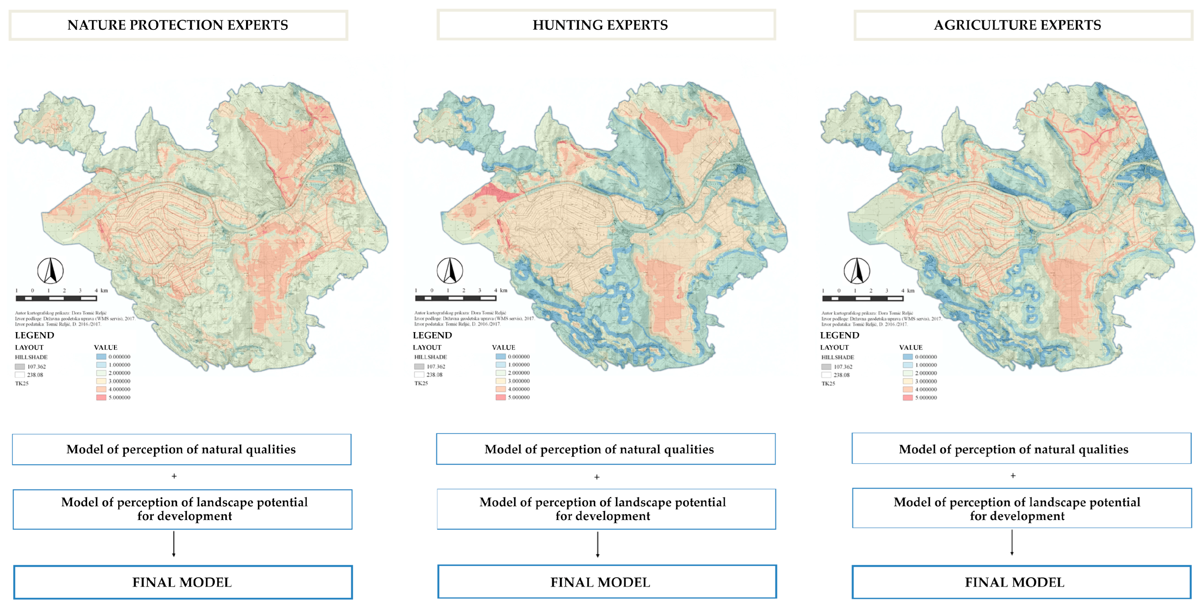
3.3.1. Examining the Perception of Natural Qualities and Landscape Potential for Development

By reviewing various strategic and sectoral documents and spatial plans of cities (Metković, Opuzen, Ploče), municipalities (Kula Norinska, Slivno, Zažablje), and Dubrovnik-Neretva County, within whose borders protection is proposed, a deeper insight into the potential of the area for the development was obtained. The review of the mentioned documents was the basis for determining the criteria for the protection and development of the area. The aforementioned criteria were used as a basis for the conceptualization of the interviews for examining the evaluation of natural qualities and landscape potential for the development of experts in three basic sectors: agriculture, hunting, and nature protection.
Many methods of landscape evaluation are focused on the qualities of landscape forms, which are determined by geographical methods (mapping certain landscape features and attributing significance to these features, conveying the results of analyzes in the form of landscape typologies or value maps) [19]. However, the determination of landscape qualities that are related to man’s relationship to the landscape cannot be conveyed by a geographical approach, and that is why social research that focuses on perception is used [19]. Therefore, the results of the previous research [77] were used in the modeling process. It was based on a qualitative method of low-structured interviews conducted on a sample of respondents who represented these three previously mentioned sectors. The research [77] was conducted on a convenient sample of respondents with different educational profiles and places of employment. The focus of the research was on the personally perceived values of experts, which is why the low-structured interview method was used. After conducting the investigation, the results of the interviews were documented with transcripts, systematized, and marked. Interviews were processed using the descriptive interview coding method, and qualitative analysis was used for data processing. After listening to the recordings, transcripts were made, and notes were reviewed. The data were then systematized and divided into categories with the purpose of better understanding and interpretation. Then, the topics and questions of the interview were separated, and the respondents’ statements were explained inside. The coding of the interviews was carried out according to the themes that crystallized during the interpretation of the transcripts. Each topic was defined by one word or short phrase, which became a code. Codes are defined so that they can be consistently applied in multiple interviews and later externalized into spatial variables. With regard to the given topic or question, the basic terms of the empirical material are identified below, which were analyzed and interpreted with the aim of forming criteria for modeling. As the goal of the research is to obtain the opinions and attitudes of a certain group of respondents that can be compared, the data are divided into three categories according to the affiliation of the respondents to a certain group of experts. Based on the analysis of respondents’ answers, a difference in the value attitudes of experts towards the examined issue was determined. The results of qualitative research conducted with experts in the field of nature protection, agriculture, and hunting, presented in previous research [77], were used to conceptualize a model of perception of natural qualities and landscape potential for each group of experts.

3.3.2. Externalization of Spatial Variables and Creation of Value Models

According to Milas [78] p. 605, qualitative analysis is based on a visual presentation of data, summarized and refined, from which it is possible to draw conclusions. Procedures and techniques for interpretation in qualitative analysis have their basis in “mental statistics”, in which words are replaced by numbers [78], whereby in this paper, the techniques of noticing patterns and themes, comparing and contrasting, and noticing connections between variables were used (mental calculation of correlation by paying attention to changing one in relation to the other). Externalization of spatial variables used in this paper is an approach for the determination of spatial information characteristics, which can be described and cartographically presented through the differentiated criteria. In order to create cartographic spatial representations of the criteria, it was necessary to prepare a valid database of spatial data adjusted to codes obtained from the interview. All the collected data were systematized and adjusted to the selected coordinate system (HTRS96/TM) and the research area in QGIS. Data (shapefiles) used for the spatial maps of natural qualities were terrestrial habitats, sea benthos, Natura2000 sites, and nature protection areas of the Republic of Croatia taken from Bioportal, official state web service (https://services.bioportal.hr/wfs (accessed on 14 April 2017)), CORINE Land Cover Croatia digital database, Croatian soil map, and DEM. The locations which have been mentioned by respondents as valuable, but are not part of the official state data, were manually digitalized (vectorized) by collecting data from secondary sources (digital orthophoto maps from different time periods, Croatian base map, topographic maps scales 1:25,000 and 1:100,000). Pressures and loads that impact nature do not represent spatial attributes but rather potential and present land use. So, spatial maps of pressures and loads were generated from the vector shape files (*.shp) on the land use map derived from accurate spatial plans (counties, cities, and municipalities). For the spatial maps of landscape potential (the most important human activities within the research area, existing values, and spatial potentials which are not used yet), vector shape files (*.shp) on land use (agricultural land, commercial area, touristic areas, fishing zone, and road infrastructure system) were used. The spatial potentials which have been noticed by respondents as significant, but are not part of the official state data, were manually digitalized (vectorized) by collecting data from the secondary sources (digital orthophoto maps from different time periods, a Croatian base map, topographic maps scales 1:25,000 and 1:100,000), by overlapping those spatial features that would achieve these potentials and are needed to develop these activities in space (Figure S1).
As one of the methods of verifying the validity of the findings obtained through qualitative research, the author mentions data weighting, which was used in this research. The method of assigning values to specific data in this work was carried out using the AHP method (analytical hierarchy process), which was developed by Saaty [75]. The process divides the data obtained into simple comparisons between two criteria, which simplifies the weighting process and creates clearer and stronger criteria for evaluation [79]. The BPMSG AHP calculator <04.05.2016> was used to obtain the values [80].
The size of the buffer zone for wetland habitats was determined according to Semlitsch and Jensen [81]; 60 m from the boundary of the wetland area is designated as a water zone, then 164 m from the boundary is the core of the habitat, and 50 m from the core of the habitat, the earth zone. Transition zones for protected areas generally differ and depend on objectives, land availability, and traditional land use system, as well as potential hazards and opportunities [82]. In addition, transition zones are most often located on private land, and therefore state initiative in stimulating the use of land in a manner compatible with the biological requirements of the protected area is very important [83]. In this work, the transition zone is determined at a distance of 1 km around the protected area because within that zone, according to Croatian Agency for Environmental Protection [84], pressures still affect the components of its biological diversity. Each specific characteristic was given a weight derived from the AHP, and thus certain criteria were given a greater or lesser value by a certain group of respondents, which resulted in more precise representations of value models.
The creation of value models is based on the overlapping method [85], and for the creation of the model, the spatial database for the researched area was used. The database that was used in this work was partially taken from the existing database of the Department of Ornamental Plants, Landscape Architecture and Garden Art (the University of Zagreb, Faculty of Agriculture) and was partially created and supplemented based on cartographic representations of spatial plans of counties and municipalities downloaded from the WMS service Spatial Planning Information System (https://ispu.mgipu.hr/ (accessed on 14 April 2017)), cartographic representations downloaded from the WMS service of the State Geodetic Administration (http://www.geoportal.hr/ (accessed on 14 April 2017)); WFS service of the nature protection information system (http://www.bioportal.hr/gis/ (accessed on 14 April 2017)) and the Environmental Protection Agency (http://gis.azo.hr/services.html (accessed on 14 April 2017)). Certain spatial data that were not available, but were necessary for the creation of value models, were vectorized based on the analysis and interpretation of the respondents’ answers. The tools that were used for modeling, comparison, and graphic creation of value map representations are the GIS applications ArcGIS® Desktop <9.2.> (ESRI), QGIS; <2.8.7., 2.14.9 and 3.10.5>. (QGIS Development Team), IDRISI32 <I32.20> (Clark Labs) and ProVal 2000; <1.1.0.6> (www.realis.si, www.dioptra.si and www.gov.si/GIC/). All spatial data are recorded in the Croatian official reference coordinate system HTRS96/TM. The following georeference units were used in the ProVal2000 application: xMin, yMin 568535, 4754170: xMax, yMax 598875, 4782325.
The first spatial model, the model of perception of the natural qualities of the landscape (Figure 3), was obtained by overlapping sub-models resulting from the criteria determined by qualitative research (Table S1, Figures S2–S5) The submodels represent landscape qualities perceived by respondents and are made up of basic natural components of space such as protected areas, terrestrial habitats, relief features, soil types, surface water (rivers, streams), wetlands, and landscape and biological diversity. Each criterion for creating a sub-model was weighted based on the results of the AHP analysis.
The second spatial model, the landscape potential perception model (Figure 4), was obtained by overlapping sub-models resulting from criteria determined by qualitative research, which represent the potential of the landscape in terms of the use of space in the dimension of long-term and short-term development aspirations of individual sectors (Table S2, Figures S6 and S7). As in the first spatial model, each criterion for creating a sub-model was weighted based on the results of the AHP analysis. Submodel overlaps were performed by functions in GIS applications, which calculate the summed value of each homogeneous spatial unit (pixel, size 10 × 10 m) with respect to the values of all input matrices. The summed values are then classified into a standardized rating scale of 0–5 in order to obtain equal and comparable values.

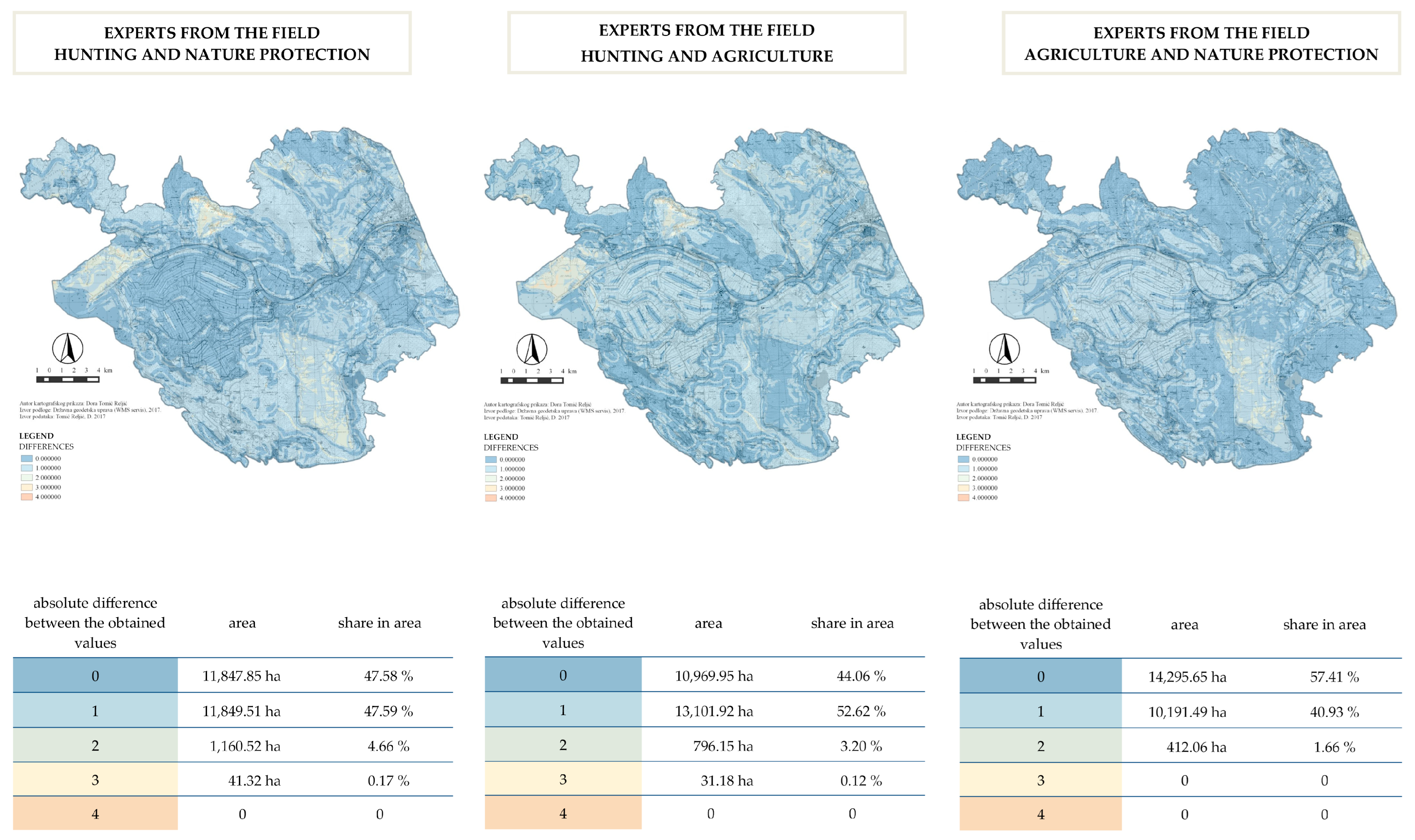
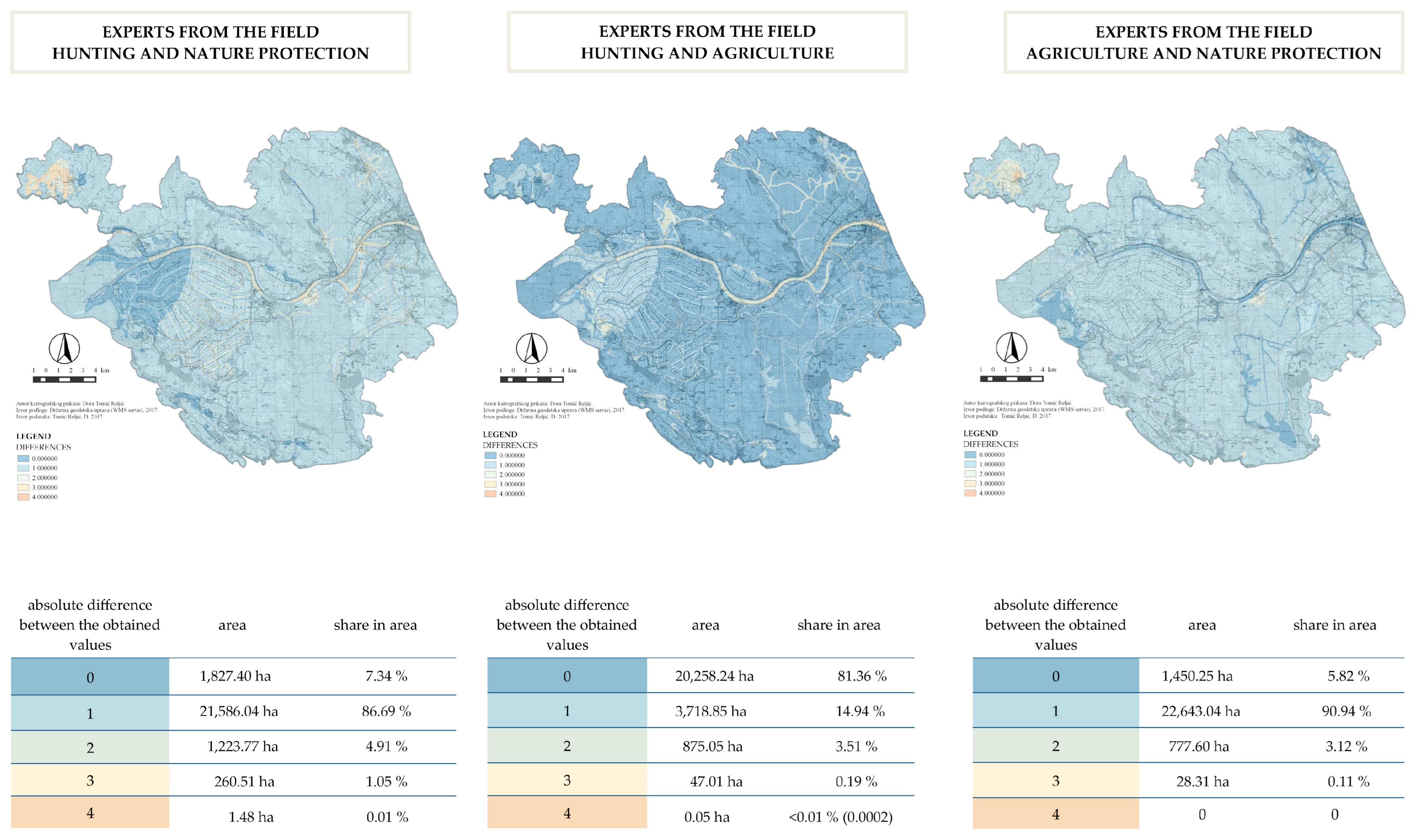
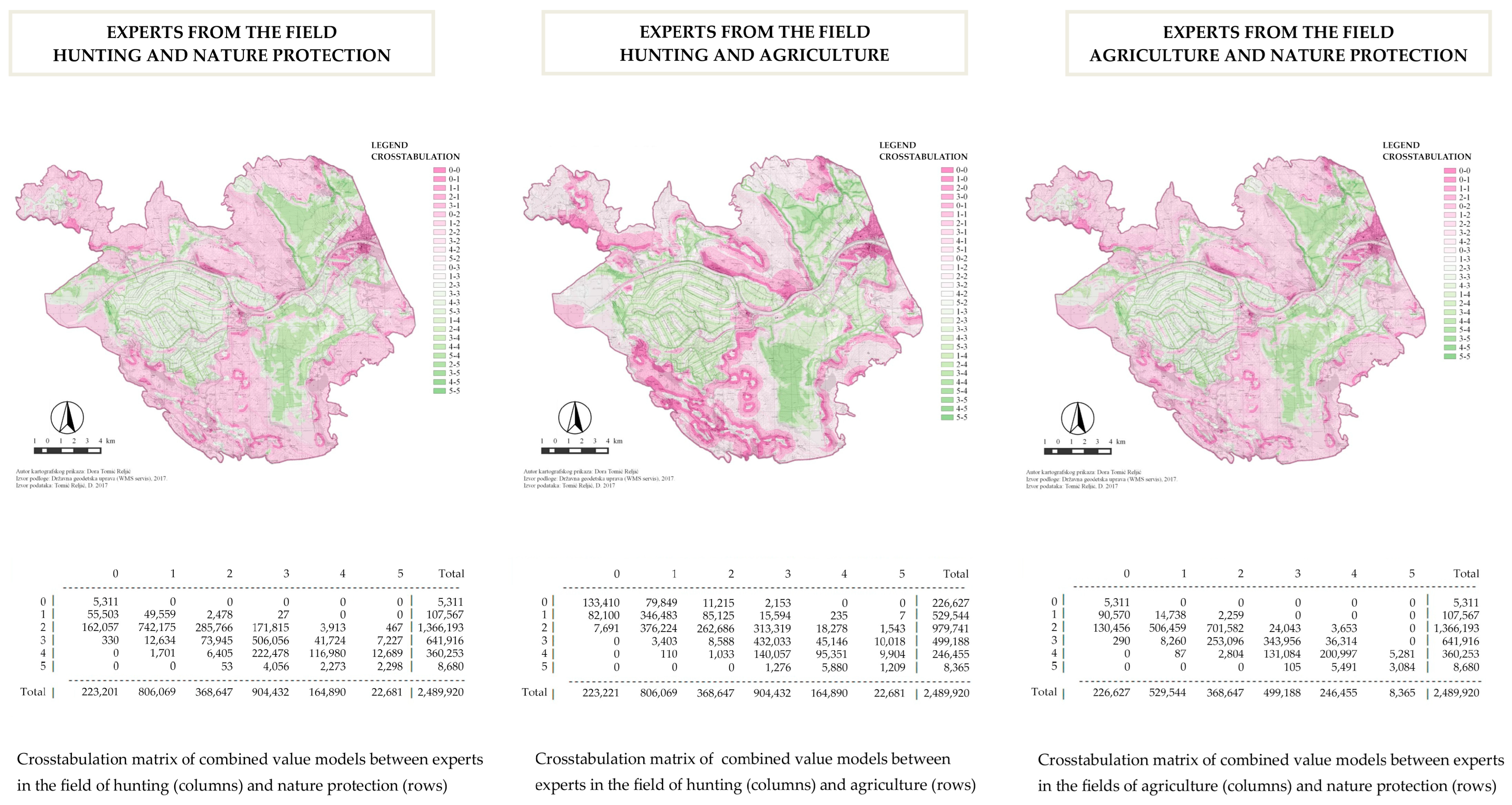
3.3.3. Crosstabulation Analysis and Differences between Models
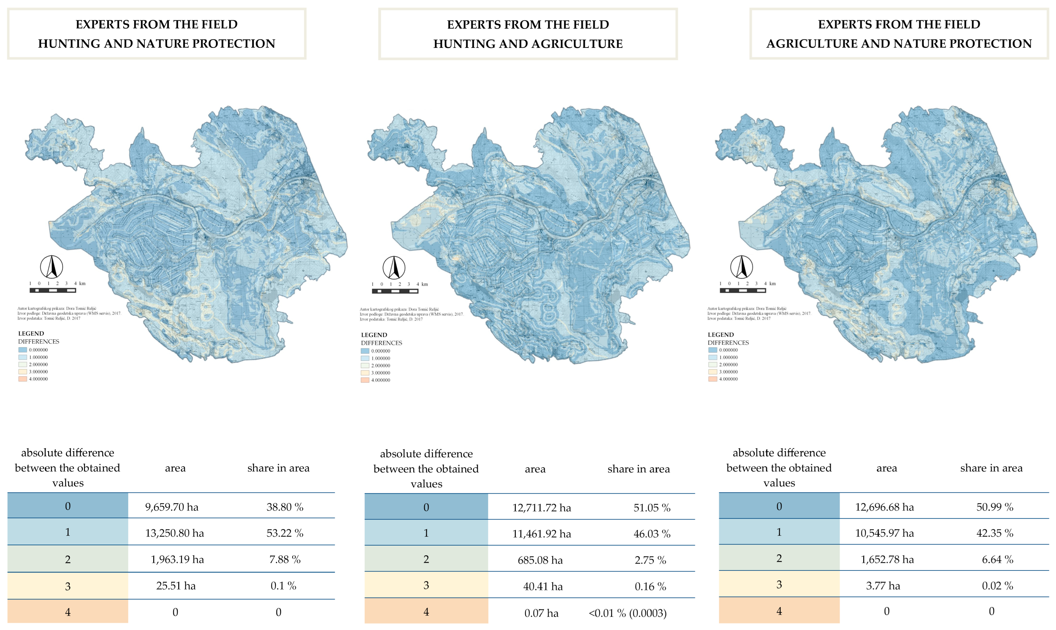
The basis for obtaining cartographic and numerical representations of the difference between the model of perception of natural qualities, the model of landscape potential for development, and the combined models was cross-tabulation analysis.
The cross-tabulation analysis was performed with the GIS applications IDRISI32 and QGIS using the Cross-classification and tabulation functions. The first step was to enter the value models of perceptions in the raster format of IDRISI software (*.rst), which were prepared in advance, or transformed from *.geotiff format into *.rst. By running the Cross-classification and tabulation function, two models are entered that are to be compared with each other. Considering that in work, it was necessary to perform crosstabulation for three groups of respondents, three combinations were entered for each model in order to compare all groups with each other.
The result of the crosstabulation analysis procedure is a graphical and tabular representation of the overlap of perceived values between groups of respondents. On the basis of these obtained cartographic representations, information emerges about how the same areas were evaluated between groups of respondents. At the same time, all the value relationships that occur during the crosstabulation procedure in GIS are shown for each pair of groups of respondents. The tables resulting from the crosstabulation procedure contain an automatic calculation of the area of overlap of the perceived values in measurement units of pixel size in the raster record of spatial data, which in this case is 100 m2 (10 × 10 m). Crosstabulation tables and spatial data resulting from this analysis are the basis for calculating the difference between perceived values. The creation of cartographic and numerical representations of the differences between perception models is described and shown in more detail below.
Based on the calculation of the difference in the values of the overlapped models using the classification function (Band rendering, QGIS), a cartographic representation of the difference between the obtained spatial models was obtained. The method of showing the difference used by Hewlett et al. [67] was adapted and used for this procedure. Therefore, the absolute difference is indicated here in the maps and the accompanying attribute tables.
The absolute difference between the perceived values between all groups (Table 1) was used for the reason that it indicates those parts of the space where there were the largest or smallest deviations in the perception of quality between the groups (e.g., an absolute difference of 5 is obtained only in the case when 2 homogeneous spatial units with values 0 and 5 or vice versa, while the absolute difference 0 is obtained by overlapping homogeneous spatial units of equal values).

4. Results

The first model, the model of the perception of natural qualities, was obtained by overlapping and summarizing sub-model 1—characteristic natural value, sub-model 2—the most significant locations in the context of naturalness, sub-model 3—basic characteristics of areas with prominent naturalness and sub-model 4—pressures and loads affecting the naturalness of the area, for each group of experts separately (Figure 3). Second model, the model of perception of landscape potential for development was obtained by overlapping and summarizing sub-model 5—the most significant human activity in the area of the Neretva Delta and sub-model 6—existing values and potentials of space that have not been used so far (Figure 4).
The obtained models of the perception of natural qualities and the models of the perception of landscape potential for development were then overlapped with each other with a matrix (Matrix function, ProVal). The result of such an overlap (see Figure 5) was to obtain those locations that the respondents consider having the potential for development, and at the same time, they are located in those areas that they do not perceive as a natural quality. Future development in such locations will certainly not create new conflicts because the optimization approach has avoided locating them in areas of natural quality while at the same time directing them to those locations that have great development potential.
The results of the cross-tabulation analysis and the differences between the models of the perception of natural qualities (see Figure 6) indicate that the absolute difference of 0 in the perception of natural qualities (perceived as equally valuable) between pairs of expert groups from the fields of hunting and agriculture and hunting and nature protection appears on less than 50% of the area, except between experts in the fields of agriculture and nature protection where 57.41% of the area was perceived as equally valuable. The absolute difference of 1 does not indicate a large deviation, and based on it, it cannot be concluded that there is a significant difference between the perception of natural qualities. However, regardless of the obtained absolute difference of 2, 3, or more, the absolute difference of 1 still represents a difference in basing the perception on different values. The difference in value models, shown even to the smallest extent, should not be ignored because it can be a source of conflicts or at least misunderstanding in practice.
The results of cross-tabulation analysis and the difference between models of the perception of landscape potential for development (see maps and tables in Figure 7) show that the absolute difference in the perception of the potential between hunting and agriculture experts on 81.36% of the area is 0, that is, there is no difference. However, in the comparison of the model and both groups of respondents with the model of experts in the field of nature protection, the results indicate that the absolute difference is 0 (perceived as equally valuable) in less than 10% of the area. (Simultaneously, on the majority of the surface, the absolute difference is 1. The above leads to the conclusion that experts from the field of hunting and agriculture perceive the landscape’s potential for development almost equally and that their perception, although not in a big absolute difference, differs from the perception of experts from the field of nature protection. The first reason for this can be the fact that the representatives of expert groups in the field of hunting and agriculture are people who can be considered local residents, and as experts in the area, they see much more development potential than experts in the field of nature protection. Another reason may be that nature protection experts belong to the protection sector, unlike experts from the fields of agriculture and hunting who belong to the development sectors, who are expected to have a better perception of the development possibilities of the area based on the potential that a certain area has. The above should be verified in further research in which the perception of the local population on the potential of the landscape (space) for development would be examined with the aim of establishing development criteria. Some authors [12,26,86] point to the need for such research.
The results of the cross-tabulation analysis of cartographic representations (see maps and tables in Figure 8) and the differences between the combined models of the perception of natural qualities and landscape potential for development (see maps and tables in Figure 9) indicate that the absolute difference 0 in the perception of natural qualities and landscape potential for development between groups of experts in the field of hunting and agriculture and between experts in the field of agriculture and nature protection appears on about 50% of the surface, except between groups of experts in the field of hunting and nature protection where 38.80% of the surface has an absolute difference of 0, i.e., it is perceived as equally valuable. Analogously, the absolute difference 1 between all experts is around 50%. As already mentioned, although small, it still represents a difference in value perception and should not be ignored.

5. Discussion

Starting from the assertion that the landscape is not only a part of the territory or a part of the environment, or a part of space but a complete spatial phenomenon with its qualities and subjective and objective attributes that changes due to changes in human activities in space this research pointed to the importance of landscape research and perception its values as a basic step in resolving conflicts between development and protection of space. Butula [87] points out that the task of spatial planning is to investigate how certain groups perceive space and its qualities and to determine to what extent they are ready to accept protection at the expense of development interests and vice versa with the aim of harmonizing interests and achieving sustainability in spatial development. In this research, it was necessary to determine the ways of protecting the area, especially in the context of nature protection as the dominant approach in the protection of the Neretva Delta area. An important fact about the area that must also be taken into account when looking at the potential protection of the area is that a large part of the Neretva Delta area is not a natural landscape but a cultural one, which was created under the influence of human activities in the area, in this case, a predominant activity for 70 years is agriculture. Identification, preservation, and adequate management of rural cultural landscapes is a duty to which the Republic of Croatia has committed itself by accepting a number of international conventions, strategies, directives, and recommendations (e.g., Convention on European Landscapes, 2000, Mediterranean Action Plan of the United Nations for the environment, 2005, NATURA 2000, European Spatial Development Policy, 1999) but also which is announced through the priority guidelines of a series of sector strategies of the old and new generations (sectors of nature protection, environmental protection, cultural heritage protection, spatial development, rural development, and development tourism). The Neretva Delta area has also been proposed for registration in the register of cultural assets of the Republic of Croatia and protection at the national level [88]. So, for further research, it is also considered useful to examine the effectiveness of multi-level management of protected areas, which is present in many locations in the Republic of Croatia. This especially applies to an area such as the Neretva Delta, where, in addition to the protection of natural values, there are many other interests in the area that are often contradictory or difficult to reconcile with the goals of nature protection. It can also be concluded that the initiative to declare the area of the Neretva Delta a nature park, a new category of protection in that system, is an additional source of conflict between users of the area, which is confirmed by previous research by many authors [32,89,90,91]. Although a lot of important information was obtained from the answers of the respondents, that is, the results of the qualitative research, in this research, the emphasis was placed on the methodological problem that was tried to be solved, which is the transformation of the views of experts into the modeling process. The process of making decisions about changes in space is, on the one hand, a very important factor for all stakeholders in the space, and on the other hand, it is also a task of spatial planning. So, the views of the public, as well as experts, must be included in that process. However, considering that the entire procedure is based on the analysis of spatial data, it was necessary to find a simple way to transform the different opinions of stakeholders into spatial data that can be input to planners. This was the basis for determining the methodological procedure for the creation of cartographic and numerical representations of different views that can be compared and clearly readable by the developers in the process of adopting spatial planning documentation and thus implemented in the process itself. The limitation of this approach is that during the reconciliation of many different and sometimes subjective views in the process of transformation into spatial data, simplification may occur, which may result in the loss of some information.
This research has shown that the attitudes and values obtained through the application of a low-structured interview can be compared with each other only by applying qualitative research techniques, while by applying the techniques of creating value models, they can only be cartographically displayed and implemented in the planning process. Combined models of perception of natural qualities and landscape potential for development are obtained by cumulative overlay (weighted linear sum obtained by applying fuzzy logic), and therefore the differences between experts in the field of nature protection, hunting and agriculture in cartographic value representations are not so prominent.
The analysis of the results of the examination of the perception of natural qualities and the potential of the landscape for development showed that the transformation of attitudes from a low-structured interview into criteria that can be spatially displayed and then modeled is a very methodologically demanding and complex task. The reason for this is the conversion of interpretation and synthesis of qualitative research into spatial modeling in GIS tools. Unlike the research conducted by Andlar [92], in which the interview analysis did not significantly affect the final structure of the value criteria, in this research, the questioning of experts conducted through the form of a low-structured interview was the basic source for shaping the modeling criteria. The opening of new possibilities for the transformation of value attitudes into spatial models that can be displayed cartographically is seen as a problem area for further research. This paper was carried out by examining the application of the vulnerability model in resolving conflicts in space.
The inclusion of protection and development goals in the planning process before making decisions about the space can certainly contribute to the overall protection of the space, which is an important factor in the strategic approach to sustainable (spatial) development. This paper highlights the effectiveness of the model, which, in addition to expert value assessments, can also include value models derived from the views of the public. In this case, these were the results of the examination of the perception of the value of natural qualities and the potential of the landscape for development, which was created for each group of respondents through the process of determining criteria, externalizing spatial variables, and creating a model. Given that it was indicated that the views of certain expert groups might differ on certain issues, it is important to obtain a harmonized model that will simultaneously include the views of all relevant groups, which in this example is a combined model of the perception of natural qualities and landscape potential for development. It is important to note here that, apart from examining the opinions of experts, which was the basis for this research, the same procedure can also be used to include the opinions of different social groups, i.e., the general public. The transformation of public attitudes, whether professional or lay, into value models that can be cartographically displayed and implemented in the system of landscape modeling and thus included in the spatial planning process is a very important step in planning sustainable spatial development. It can also be added that, in addition to sectoral requirements arising from expert opinions, the inclusion of landscape evaluation in the spatial planning process contributes to the optimization of social requirements arising from public opinions. The importance of modeling landscape values in the preparation of spatial planning documentation at the strategic level in domestic practice is also confirmed by Krpan et al. [93], who emphasize that the data obtained through such a procedure form the basis for determining areas for development and for all other possible changes in space. At the same time, the authors believe that such a procedure can contribute to the resolution of conflicts and controversies, as indicated by this research. Based on all the results obtained in this research, the proposed method of including landscape quality modeling in the planning process is considered an adequate tool for optimizing spatial decisions that can simultaneously include protective, developmental, and social requirements, which can also be considered a prerequisite for achieving sustainable spatial development.

6. Conclusions

This paper explored the need to examine landscape values and public participation in the process of making decisions about changes in space as an important segment in harmonizing protection and development requirements in the planning of sustainable spatial development. The method of obtaining this information was determined, and new approaches in landscape research were examined through the perception of its values as an initial step in resolving conflicts between development and space protection.
In the researched area, conflicts between the viewpoints of different stakeholders, as well as resistance to the protection of space, have been present for ten years. Therefore, one of the goals of this work was to determine the evaluation criteria of the basic natural qualities and landscape potential of respondents (experts) from different sectoral activities in the researched area. By examining the evaluation criteria of natural qualities and landscape potential for development, this research proved that the evaluation criteria based on the perception of natural qualities differ between experts from the sectors dominant in this area; hunting, nature protection, and agriculture. Furthermore, the research proved that the evaluation criteria based on the perception of the potential of the landscape for development do not differ between the mentioned groups. However, it was also determined that groups of experts from the field of hunting and agriculture, compared to experts from the field of nature protection, perceive more potential for development in the researched area, which is connected here with the local knowledge of the respondents of these two groups. Some previous research indicates differences in the attitudes between different stakeholders regarding the issue of spatial planning, so the aim of the research was to establish a methodological framework for solving problems and conflicts in space through the transformation of experts’ attitudes into an appropriate format that can be implemented in the planning process.
As a basic tool in the methodology of presenting and involving different segments of the public, whether professional or lay, in the process of spatial planning, the approach of modeling the landscape qualities of space is presented. The usefulness of such an approach was demonstrated primarily in the possibility of creating a cartographic presentation of a harmonized model that simultaneously includes the views of all relevant groups and can be easily implemented in the planning process before making decisions using GIS tools. The tool can be adapted with regard to the specificity of the location, the stakeholders that need to be included in the process, and the spatial problem and conflicts that need to be resolved before making a decision about changes in the space. This contributes to solving practical problems in the protection of landscape qualities, which, as it turned out from a theoretical level, essentially represent a public good and a link between nature and culture, as well as biophysical, experiential, social, and developmental elements in space.

Supplementary Materials

The following supporting information can be downloaded at: https://www.mdpi.com/article/10.3390/land12010250/s1, Figure S1: Externalization of Spatial Variables; Figure S2: Modeling perception of natural qualities—Submodel 1—characteristic natural values; Figure S3: Modeling perception of natural qualities—Submodel 2—the most significant locations in the context of naturalness; Figure S4: Modeling perception of natural qualities—Submodel 3—basic characteristics of areas with outstanding naturalness; Figure S5: Modeling perception of natural qualities—Submodel 4—pressures and loads that affect the naturalness of the area; Figure S6: Modeling perception of landscape potential for development—Submodel 1—the most important human activities in the area of the Neretva delta; Figure S7: Modeling perception of landscape potential for development—Submodel 2—unused existing values and potentials; Table S1: Criteria for modeling perception of natural qualities; Table S2: Criteria for modeling perception of landscape potential for development.

Author Contributions

Conceptualization, D.T.R. and S.B.; methodology, D.T.R. and S.B.; software, D.T.R.; formal analysis, D.T.R.; investigation, D.T.R. and S.B.; resources, D.T.R. and P.P.; data curation, P.P. and I.H.; writing—original draft preparation, D.T.R. and M.K.; writing—review and editing, M.K.; visualization, D.T.R. and M.K.; supervision, P.P. and I.H.; project administration, S.B. All authors have read and agreed to the published version of the manuscript.

Funding

This research received no external funding.

Institutional Review Board Statement

The study was conducted in accordance with the Declaration of Helsinki and with Code of Ethics of the University of Zagreb (article 16, paragraph 2; class: 012-03/07-03/2; order number: 380-07/1-09-5; Zagreb, Croatia, 18 May 2007).

Informed Consent Statement

Informed consent was obtained from all subjects involved in the study.

Data Availability Statement

Not applicable.

Conflicts of Interest

The authors declare no conflict of interest.

References

  1. HJP (Hrvatski Jezični Portal). Available online: http://hjp.znanje.hr/ (accessed on 14 April 2017).
  2. Croatian Official Gazette, 30/09. Sustainable Development Strategy of the Republic of Croatia. Croatian Parliament; Zagreb. 2009. Available online: https://narodne-novine.nn.hr/clanci/sluzbeni/2009_03_30_658.html (accessed on 10 November 2022).
  3. Tomić, D.; Butula, S. Poimanje Kriterija Održivog Razvoja u Zaštiti Krajobraza. In Zbornik Radova Znanstvenog Simpozija s Međunarodnim Sudjelovanjem “Razvoj i Okoliš—Perspektive Održivosti”; Galić, B., Žažar, K., Eds.; FF Press: Zagreb, Croatia, 2013; pp. 81–94. [Google Scholar]
  4. Breskvar Žaucer, L.; Zupan, B.; Golobič, M. Analysis of preference maps using data mining methods. Geod. Vestn. 2009, 53, 1. [Google Scholar]
  5. Eiter, S. Landscape as an Area Perceived through Activity: Implications for Diversity Management and Conservation. Landsc. Res. 2010, 35, 339–359. [Google Scholar] [CrossRef]
  6. Ipsen, D. The sociology of landscape. In Exploring the Boundaries of Landscape Architecture; Bell, S., Sarlöv Herlin, I., Stiles, R., Eds.; Routledge: London, UK; New York, NY, USA, 2012; pp. 60–82. [Google Scholar]
  7. Makarow, M.; Rodriguez-Peña, Á.; Žic-Fuchs, M.; Caball, M. Landscape in a Changing World. Sci. Policy Brief. 2010, 41, 1–15. [Google Scholar]
  8. Gobster, P.H.; Xiang, W.-N. Editorial—A revised aims and scope for Landscape and Urban Planning: An International Journal of Landscape Science, Planning and Design. Landsc. Urban Plan. 2012, 106, 289–292. [Google Scholar] [CrossRef]
  9. van den Brink, A.; Bruns, D. Strategies for Enhancing Landscape Architecture Research. Landsc. Res. 2014, 39, 7–20. [Google Scholar] [CrossRef]
  10. Butula, S. Landscape evaluation and public preferences: Is there room for optimization? Agric. Conspec. Sci. 2008, 73, 109–114. [Google Scholar]
  11. Scott, A. Assessing Public Perception of Landscape. The LANDMAP experience. Landsc. Res. 2002, 27, 271–295. [Google Scholar] [CrossRef]
  12. Golobič, M. Visualisation Methods as an Interface between Science and democracy in Spatial Planning. In Trends in Real-Time Landscape Visualization and Participation, Proceedings of the 6th International Conference on Information Technologies in Landscape Architecture, Anhalt, Sweden, 2005; Buhmann, E., Paar, P., Bishop, I.D., Lange, E., Eds.; H. Wichmann: Heidelberg, Germany, 2005; Available online: http://www.kolleg.loel.hs-anhalt.de/landschaftsinformatik/fileadmin/user_upload/_temp_/2005/2005_Beitraege/004/2005-004.pdf (accessed on 29 March 2016).
  13. Croatian Official Gazette. Law on Spatial Planning; Croatian Parliament: Zagreb, Croatia, 2013. Available online: https://narodne-novine.nn.hr/clanci/sluzbeni/2013_12_153_3222.html (accessed on 1 November 2022).
  14. Hermanns, T.; Helming, K.; Schmidt, K.; König, H.J.; Faust, H. Stakeholder strategies for sustainability impact assessment of land use scenarios: Analytical framework and identifying land use claims. Land 2015, 4, 778–806. [Google Scholar] [CrossRef] [Green Version]
  15. Marušič, J. Oblike vrednotenja v krajinskem načrtovanju. Urbani Izziv 1991, 18, 37–45. [Google Scholar]
  16. Marušič, J. Towards a general conservation theory. In Nature Conservation Outside Protected Areas, Proceedings of the International Conference; Ogrin, D., Ed.; Ministry of Environment and Physical Planning and Biotechnical Faculty University of Ljubljana: Ljubljana, Slovenia, 1995; pp. 43–55. [Google Scholar]
  17. Butula, S. River Landscape Value Systems as a Basis for Planning. Ph.D. Dissertation, University of Zagreb, Zagreb, Croatia, 2004. [Google Scholar]
  18. Dalglish, C.; Leslie, A. A question of what matters: Landscape characterisation as a process of situated, problem-orientated public discourse. Landsc. Res. 2016, 41, 212–226. [Google Scholar] [CrossRef] [Green Version]
  19. Stephenson, J. The Dimensional Landscape Model: Exploring Differences in Expressing and Locating Landscape Qualities. Landsc. Res. 2010, 35, 299–318. [Google Scholar] [CrossRef]
  20. Healey, P. The treatment of Space and Place in the New Strategic Spatial Planning in Europe. Int. J. Urban Reg. Res. 2004, 28, 45–67. [Google Scholar] [CrossRef]
  21. Turner, T. Landscape Planning and Environmental Impact Design, 2nd ed.; The Natural and Built Environment Series; UCL PRESS, Taylor & Francis Group: London, UK, 1998. [Google Scholar]
  22. Sarlöv Herlin, I. New challenges in the field of spatial planning: Landscapes. Landsc. Res. 2004, 29, 399–411. [Google Scholar] [CrossRef]
  23. Marušič, J. Conservation planning within the framework of landscape planning in Slovenia. Landsc. Urban Plan. 1993, 23, 233–237. [Google Scholar] [CrossRef]
  24. Marušič, J. Landscape planning between standardisation and optimisation. In Landscape 21—International Journal for Planning Research and Landscape Design, Special ed.; Department of Landscape Architecture Biotechnical Faculty, University of Ljubljana: Ljubljana, Slovenia, 2010; pp. 40–45. [Google Scholar]
  25. Renn, O.; Webler, T.; Rakel, H.; Dienel, P.; Johnson, B. Public participation in decision making: A three-step procedure. Policy Sci. 1993, 26, 189. [Google Scholar] [CrossRef] [Green Version]
  26. Roe, M. Landscape Planning for Sustainability: Community Participation in Estuary Management Plans. Landsc. Res. 2000, 25, 157–181. [Google Scholar] [CrossRef]
  27. Fabos, J.G.Y. Planning and landscape evaluation. Landsc. Res. 1979, 4, 4–10. [Google Scholar] [CrossRef]
  28. Hopkins, L.D. Methods for Generating Land Suitability Maps: A Comparative Evaluation. J. Am. Plan. Assoc. 1977, 43, 386–400. [Google Scholar] [CrossRef]
  29. Ministry of Spatial Planning, Construction and Housing. Strategija Prostornog Uređenja Republike Hrvatske; Ministry of Spatial Planning, Construction and Housing: Zagreb, Croatia, 1997. Available online: https://mpgi.gov.hr/UserDocsImages//dokumenti/Prostorno/StrategijaRH//Strategija_I_II_dio.pdf (accessed on 26 August 2022).
  30. Tafra-Vlahović, M. Communication factors in cross-sectoral partnerships for sustainable development. Median.—Znan. Časopis Medije Novin. Masov. Komuniciranje Odnose Javn. Kult. Društva 2007, 1, 1–12. [Google Scholar]
  31. Jurlina Alibegović, D.; Kordej De Villa, Ž. Lokalna dimenzija održivog razvoja. In Participativno Upravljanje Za Održivi Razvoj; Kordej-De Villa, Ž., Stubbs, P., Sumpor, M., Eds.; Ekonomski Institut: Zagreb, Croatia, 2009; pp. 47–62. [Google Scholar]
  32. Penko Seidl, N.; Cof, A.; Breskvar Žaucer, L.; Marušič, I. The Problems of Large Protected Areas in the Process of Planning; A Case Study in the Municipality of Ig, Slovenia; DIGITAL Landscape Architecture Proceedings: Valletta, Malta, 2009; pp. 158–165. [Google Scholar]
  33. Bienenfeld, J. Izrada i donošenje prostornih planova u jedinicama lokalne i područne samouprave. In Proceedings of the HGK—Sektor za Trgovinu, Jedanaesti Forum Poslovanja Nekretninama, Osijek, Croatia, 10–11 November 2006; pp. 15–39. [Google Scholar]
  34. Roe, M. Editorial: Research Excellence and Landscape Research. Landsc. Res. 2013, 38, 1–3. [Google Scholar] [CrossRef]
  35. Senes, G.; Toccolini, A. Sustainable land use planning in protected rural areas in Italy. Landsc. Urban Plan. 1998, 41, 107–117. [Google Scholar] [CrossRef]
  36. Croatian Official Gazette. Uredba O Strateškoj Procjeni Utjecaja Strategije, Plana I Programa NA Okoliš; Croatian Government: Zagreb, Croatia, 2017. Available online: https://narodne-novine.nn.hr/clanci/sluzbeni/2017_01_3_117.html (accessed on 1 November 2022).
  37. Kemp-Benedict, E.J.; Bharwani, S.; Fischer, M.D. Using Matching Methods to Link Social and Physical Analyses for Sustainability Planning. Ecol. Soc. 2010, 15, 4. [Google Scholar] [CrossRef] [Green Version]
  38. Golobič, M.; Pfefferkorn, W.; Praper, S. Nove oblike odločanja za trajnostni razvoj. Urbani Izziv 2007, 18, 5–13. [Google Scholar] [CrossRef]
  39. Čaldarović, O. Konceptualizacija prirode kao vrijednosti javnog dobra i aspekti njezine valorizacije. Rev. Za Sociol. 2006, 37, 47–62. [Google Scholar]
  40. Swor, T.; Canter, L. Promoting environmental sustainability via an expert elicitation process. Environ. Impact Assess. Rev. 2011, 31, 506–514. [Google Scholar] [CrossRef]
  41. Albert, C.; Zimmermann, T.; Knieling, J.; von Haaren, C. Social learning can benefit decision-making in landscape planning: Gartow case study on climate change adoption, Elbe valley biosphere reserve. Landsc. Urban Plan. 2012, 105, 347–360. [Google Scholar] [CrossRef]
  42. Antunes, P.; Santos, R.; Videira, N. Participatory decision making for sustainable development—The use of mediated modeling techniques. Land Use Policy 2006, 23, 44–52. [Google Scholar] [CrossRef]
  43. Fitzsimons, J.; Pearson, C.J.; Lawson, C.; Hill, M.J. Evaluation of land-use planning in greenbelts based on intrinsic characteristics and stakeholder values. Landsc. Urban Plan. 2012, 106, 23–34. [Google Scholar] [CrossRef]
  44. Jones, M. The European landscape convention and the question of public participation. Landsc. Res. 2007, 32, 613–633. [Google Scholar] [CrossRef]
  45. Pegan, S. Scenariji prostornog razvoja. In Perspektive Prostornog Razvoja Republike Hrvatske: Zbornik Radova; Butijer, S., Magaš, B., Obad Šćitaroci, M., Knifić Schaps, H., Turnšek, M., Eds.; Ministarstvo Zaštite Okoliša, Prostornog Uređenja I Graditeljstva: Zagreb, Croatia, 2011; pp. 31–34. [Google Scholar]
  46. Gantar, D. Scenario use for fostered adaptation to the future landscape changes. Acta Agric. Slov. 2009, 93, 69–76. [Google Scholar] [CrossRef]
  47. Podestá, G.P.; Natenzon, C.E.; Hidalgo, C.; Ruiz Toranzo, F. Interdisciplinary production of knowledge with participation of stakeholders: A case study of a collaborative project on climate variability, human decisions and agricultural ecosystems in the Argentine Pampas. Environ. Sci. Policy 2012, 26, 40–48. [Google Scholar]
  48. Sartorio, F.S. Strategic spatial planning. DISP J. 2005, 162, 26–40. Available online: https://orca.cardiff.ac.uk/id/eprint/2295/1/disP_162_26_41.pdf (accessed on 29 March 2016). [CrossRef]
  49. Salet, W.; Faludi, A. (Eds.) The Revival of Strategic Spatial Planning; Royal Netherlands Academy of Arts and Sciences: Amsterdam, The Netherlands, 2000. [Google Scholar]
  50. Sayer, J.; Sunderland, T.; Ghazoul, J.; Pfund, J.L.; Sheilb, D.; Meijaard, E.; Venter, M.; Klintuni Boedhihartono, A.; Day, M.; Garcia, C.; et al. Ten principles for a landscape approach to reconciling agriculture, conservation, and other competing land uses. Proc. Natl. Acad. Sci. USA 2013, 110, 8349–8356. Available online: http://www.pnas.org/content/110/21/8349.full.pdf (accessed on 29 March 2016). [CrossRef] [Green Version]
  51. Fürst, C.; König, H.; Pietzsch, K.; Ende, H.P.; Makeschin, F. Pimp your landscape—A generic approach for integrating regional stakeholder needs into land use planning. Ecol. Soc. 2010, 15, 34. Available online: http://www.ecologyandsociety.org/vol15/iss3/art34/ (accessed on 29 March 2016). [CrossRef] [Green Version]
  52. Ziafati Bafarasat, A. In pursuit of productive conflict in strategic planning: Project identification. Eur. Plan. Stud. 2016, 24, 2057–2075. [Google Scholar] [CrossRef]
  53. van den Brink, A.; Bruns, D.; Tobi, H.; Bell, S. Research in Landscape Architecture: Methods and Methodology; Routledge: New York, NY, USA, 2017. [Google Scholar]
  54. Čaldarović, O. Socijalni Aspekti za Stjecanje Uvjeta za Proglašenje Dijela Ušća Neretve Parkom Prirode—Sociološka Studija; Drzavni Zavod Za Zastitu Prirode: Zagreb, Croatia, 2006. [Google Scholar]
  55. van Riper, C.J.; Kyle, G.T.; Sherrouse, B.C.; Bagstad, K.J.; Sutton, S.G. Toward an integrated understanding of perceived biodiversity values and environmental conditions in a national park. Ecol. Indic. 2017, 72, 278–287. [Google Scholar] [CrossRef]
  56. Jorgensen, A. Editorial: Is landscape an oxymoron? Understanding the focus of Landscape Research. Landsc. Res. 2015, 40, 1–4. [Google Scholar] [CrossRef]
  57. Deming, M.E.; Swaffield, S. Landscape Architecture Research; Inquiry, Strategy, Design; John Wiley and Sons: Hoboken, NJ, USA, 2011; pp. 87–113. [Google Scholar]
  58. Marušič, J. Krajinsko Planiranje; Vtozd za Agronomijo; Študij Urejenja Krajine: Ljubljana, Slovenia, 1987. [Google Scholar]
  59. Falconer, L.; Hunter, D.; Telfer, T.C.; Ross, L.G. Visual, seascape and landscape analysis to support coastal aquaculture site selection. Land Use Policy 2013, 34, 1–10. [Google Scholar] [CrossRef]
  60. Steinitz, C. A framework for theory applicable to the education of landscape architects (and other environmental design professionals). Landsc. J. 1990, 9, 136–143. [Google Scholar] [CrossRef]
  61. Steinitz, C. A Framework for Geodesign; Esri Press: Redlands, CA, USA, 2012. [Google Scholar]
  62. Marušič, J. Načrtovalska Analiza in Valorizacija Krajine—Gradivo Z Predavanj, Biotehniška Fakulteta; Agronomski Odelek, Katedra Za Krajinsko Arhitektura: Ljubljana, Croatia, 1979. [Google Scholar]
  63. Lang, S.; Blaschke, T. Analiza Krajolika Pomoću GIS-a; ITD Gaudeamus d.o.o.: Požega, Croatia, 2010. [Google Scholar]
  64. Chadwick, G. A Systems View of Planning: Towards a Theory of the Urban and Regional Planning Process; Pergamon Press: Oxford, UK, 1971. [Google Scholar]
  65. Bell, S.; Sarlöv Herlin, I.; Stiles, R. Exploring the Boundaries of Landscape Architecture; Routledge: London, UK; New York, NY, USA, 2012. [Google Scholar]
  66. Frondizi, R. What Is Value? Open Court Publish: La Salle, CO, USA, 1971. [Google Scholar]
  67. Hewlett, D.; Harding, L.; Munro, T.; Terradillos, A.; Wilkinson, K. Broadly engaging with tranquillity in protected landscapes: A matter of perspective identified in GIS. Landsc. Urban Plan. 2017, 158, 185–201. [Google Scholar] [CrossRef] [Green Version]
  68. Sandker, M.; Campbell, B.M.; Ruiz-Pérez, M.; Sayer, J.A.; Cowling, R.; Kassa, H.; Knight, A.T. The role of participatory modeling in landscape approaches to reconcile conservation and development. Ecol. Soc. 2010, 15, 13. Available online: http://www.ecologyandsociety.org/vol15/iss2/art13/ (accessed on 29 March 2016). [CrossRef] [Green Version]
  69. Eastman, J.R. Multi-criteria evaluation and GIS. In Geographical Information Systems, 2nd ed.; Goodchild, M.F., Maguire, D.J., Rhind, D.W., Eds.; Longley, John Wiley and Sons: New York, NY, USA, 1999; Volume 1, pp. 493–502. [Google Scholar]
  70. Ayalew, L.; Yamagishi, H.; Ugawa, N. Landslide susceptibility mapping using GIS-based weighted linear combination, the case in Tsugawa area of Agano River, Niigata Prefecture, Japan. Landslides 2004, 1, 73–81. [Google Scholar] [CrossRef]
  71. Greene, R.; Devillers, R.; Luther, J.E.; Eddy, B.G. GIS-Based Multiple-Criteria Decision Analysis. Geogr. Compass 2011, 5, 412–432. [Google Scholar] [CrossRef]
  72. Sarky, S.; Wright, J.; Edwards, M. Evaluating consistency of stakeholder input into participatory GIS-based multiple criteria evaluation: A case study of ecotourism development in Kurdistan. J. Environ. Plan. Manag. 2016, 60, 1529–1553. [Google Scholar] [CrossRef] [Green Version]
  73. Malczewski, J. On the Use of Weighted Linear Combination model in GIS: Common and Best Practice Approaches. Trans. GIS 2000, 4, 5–22. [Google Scholar] [CrossRef]
  74. Feizizadeh, B.; Kienberger, S. Spatially explicit sensitivity and uncertainty analysis for multicriteria-based vulnerability assessment. J. Environ. Plan. Manag. 2017, 60, 2013–2035. [Google Scholar] [CrossRef]
  75. Saaty, T.L. A Scaling Method for Priorities in Hierarchical Structures. J. Math. Psychol. 1977, 15, 234–281. [Google Scholar] [CrossRef]
  76. Jiang, H.; Eastman, J.R. Application of fuzzy measures in multi-criteria evaluation in GIS. Int. J. Geogr. Inf. Sci. 2000, 14, 173–184. [Google Scholar] [CrossRef]
  77. Tomić Reljić, D.; Čaldarović, O.; Butula, S. Modeling the Experts’ Attitudes on Natural Qualities of the Landscape within the River Neretva Valley. J. Central Eur. Agric. 2020, 21, 881–895. [Google Scholar] [CrossRef]
  78. Milas, G. Research Methods in Psychology and Other Social Sciences; Naklada Slap: Jastrebarsko, Croatia, 2005. [Google Scholar]
  79. Eastman, J.R. IDRISI Kilimanjaro Guide to GIS and Image Processing; Manual Version 14.00; Clark Labs: Worchester, MA, USA, 2003. [Google Scholar]
  80. Goepel, K.D. Implementing the Analytic Hierarchy Process as a Standard Method for Multi-Criteria Decision Making In Corporate Enterprises—A New AHP Excel Template with Multiple Inputs. In Proceedings of the International Symposium on the Analytic Hierarchy Process, Kuala Lumpur, Malaysia, 19–23 June 2013; pp. 1–13. Available online: https://bpmsg.com/wordpress/wp-content/uploads/2013/06/ISAHP_2013-13.03.13.Goepel.pdf (accessed on 5 April 2019).
  81. Semlitsch, R.D.; Jensen, J.B. Core Habitat, Not Buffer Zone. In National Wetlands Newsletter; Environmental Law Institute: Washington, DC, USA, 2001; Volume 23, pp. 5–11. [Google Scholar]
  82. Ebregt, A.; De Greve, P. BUFFER ZONES and their MANAGEMENT. In Policy and Best Practices for Terrestrial Ecosystems in Developing Countries; National Reference Centre for Nature Management (EC-LNV) International Agricultural Centre (IAC): Wageningen, The Netherlands, 2000; Available online: https://edepot.wur.nl/118089 (accessed on 18 December 2022).
  83. Alexandre, B.; Crouzeilles, R.; Viveiros Grelle, C.E. How Can We Estimate Buffer Zones of Protected Areas? A Proposal Using Biological Data. Nat. Conserv. Braz. J. Nat. Conserv. 2010, 8, 165–170. [Google Scholar] [CrossRef]
  84. Croatian Agency for Environmental Protection. Terrestrial Environmental Pressures on Protected Areas; Kučar Dragičević, S., Ed.; Croatian Agency for Environmental Protection: Zagreb, Croatia, 2007.
  85. McHarg, I. Design with Nature; The Natural History Press: New York, NY, USA, 1969; pp. 67–117. [Google Scholar]
  86. Thomas, L.; Middleton, J. Guidelines for Management Planning of Protected Areas; IUCN: Gland, Switzerland; Cambridge, UK, 2003; pp. ix + 79p. Available online: https://portals.iucn.org/library/efiles/documents/pag-010.pdf (accessed on 5 September 2019).
  87. Butula, S. Planning for sustainable development: The significance of different social interests in landscape. Društvena Istraživanja 2003, 12, 427–441. [Google Scholar]
  88. Bilušić Dumbović, B. Prepoznavanje i Vrednovanje Kulturnih Krajolika Dubrovačko Neretvanske Županije. Studija; Za Potrebe Izmjena i Dopuna Prostornog Plana Dubrovačko-Neretvanske Županije: Dubrovnik, Croatia, 2016. [Google Scholar]
  89. Payés, A.C.L.M.; Pavão, T.; dos Santos, R.F. The conservation success over time: Evaluating the land use and cover change in a protected area under a long re-categorization process. Land Use Policy. 2013, 30, 177–185. [Google Scholar] [CrossRef]
  90. Lupp, G.; Konold, W. Landscape Preferences and Perception of Both Residents and Tourists: A Case Study in Müritz National Park (Germany). In Visitor Management in Nature-Based Tourism. Strategies and Success Factors for Parks and Recreational Areas; Siegrist, D., Clivaz, C., Hunziker, M., Iten, S., Eds.; HSR University of Applied Sciences Rapperswil, Institute for Landscape and Open Space: Rapperswil, Switzerland, 2008; Volume 2, pp. 47–58. [Google Scholar]
  91. Blagojević, I. Sustainable Landscape Management in Tara National Park (Village Jagoštica, Serbia). Geogr. Pannon. 2012, 16, 94–102. [Google Scholar] [CrossRef]
  92. Andlar, G. Outstanding cultural landscapes of coastal Croatia. Ph.D. Thesis, University of Zagreb, Zagreb, Croatia, 2012. [Google Scholar]
  93. Krpan, L.; Milković, M.; Štimac, M. Functional-nodal method of the development of strategic spatial planning documentation. Tehnički Vjesnik 2014, 21, 207–215. [Google Scholar]
Figure 1. Location of river Neretva delta in the regional and national context.
Land 12 00250 g001
Figure 2. Neretva delta landscape (a) Kuti lake, (b) trenches landscape pattern, (c) reeds by the river, (d) Mediterranean fines of high sieves, (e) sandbanks at the mouth of the river Neretva.
Land 12 00250 g002
Figure 3. The process of creating models of the perception of natural qualities.
Land 12 00250 g003
Figure 4. The process of creating models of landscape potential for development.
Land 12 00250 g004
Figure 5. The process of creating a combined model.
Land 12 00250 g005
Figure 6. Cross-tabulation maps and matrices.
Land 12 00250 g006
Figure 7. Cross-tabulation maps and matrices.
Land 12 00250 g007
Figure 8. Cross-tabulation maps and matrices.
Land 12 00250 g008
Figure 9. Differences between obtained values.
Land 12 00250 g009
Table 1. All theoretical possibilities of combinations of cross-tabulated values to determine the absolute difference.
Respondent Group 1
012345
Respondent group 20012345
1101234
2210123
3321012
4432101
5543210
Note: Red color represents the largest deviation, while blue represents the smallest deviation.
Disclaimer/Publisher’s Note: The statements, opinions and data contained in all publications are solely those of the individual author(s) and contributor(s) and not of MDPI and/or the editor(s). MDPI and/or the editor(s) disclaim responsibility for any injury to people or property resulting from any ideas, methods, instructions or products referred to in the content.

