
Spatiotemporal Patterns in and Key Influences on Cultivated-Land Multi-Functionality in Northeast China’s Black-Soil Region


Abstract
:1. Introduction
2. Materials and Methods
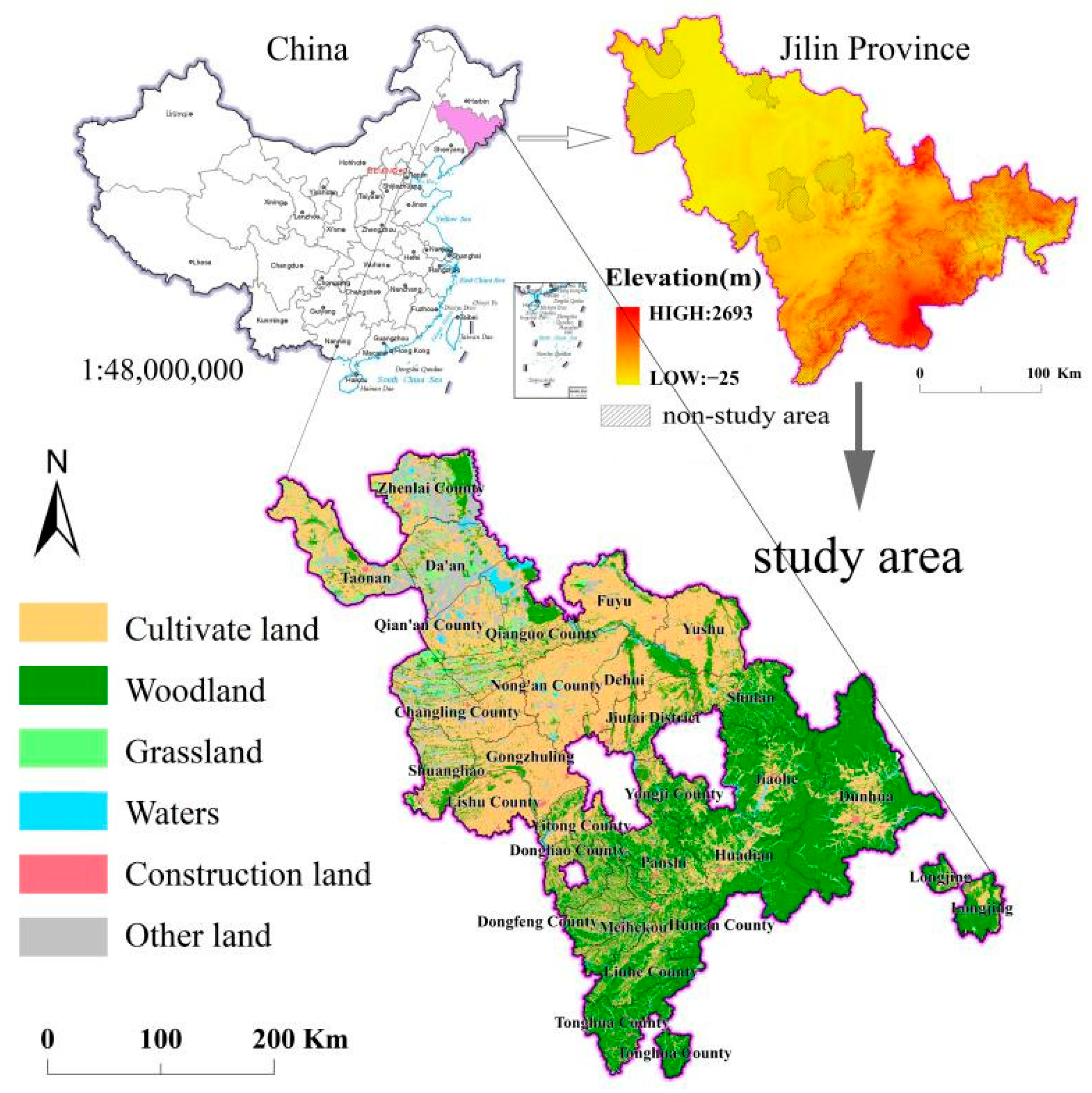
2.1. Study Area
2.2. Data Collection and Pre-Processing
2.3. Methods
2.3.1. Classification and Quantification of the Multi-Functional Value of Cultivated Land
2.3.2. Calculating the Multi-Functional Utilization of Cultivated Land and Determining any Obstacles
2.3.3. Analysis of the Coupling and Coordination Relationships among Various Sub-Functions of Cultivated Land
2.3.4. Analysis of the Key Drivers of Multi-Functionality of Cultivated Land
3. Results
3.1. Spatiotemporal Variation in and Main Obstacles to the Multi-Functionality of Cultivated Land
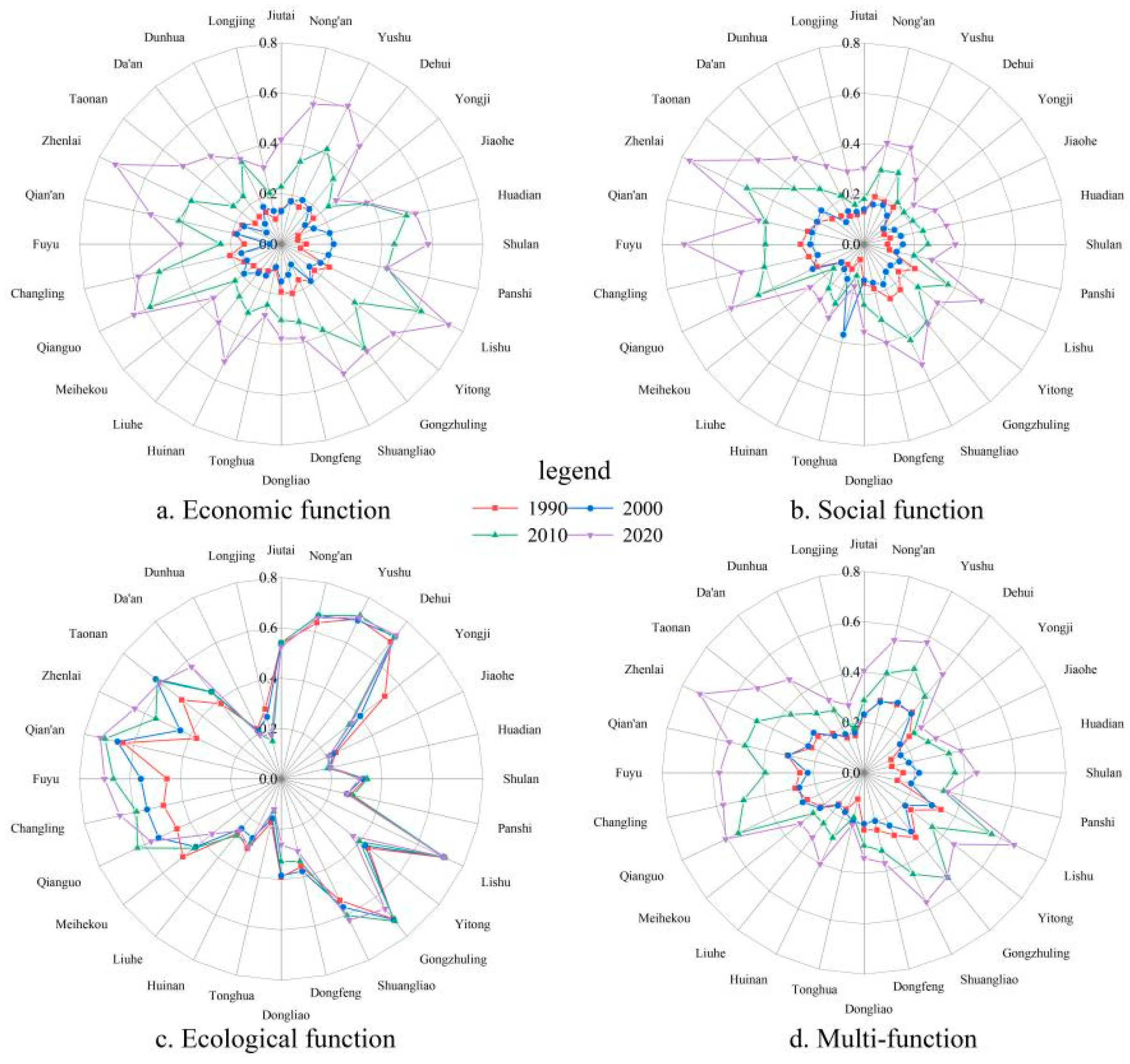
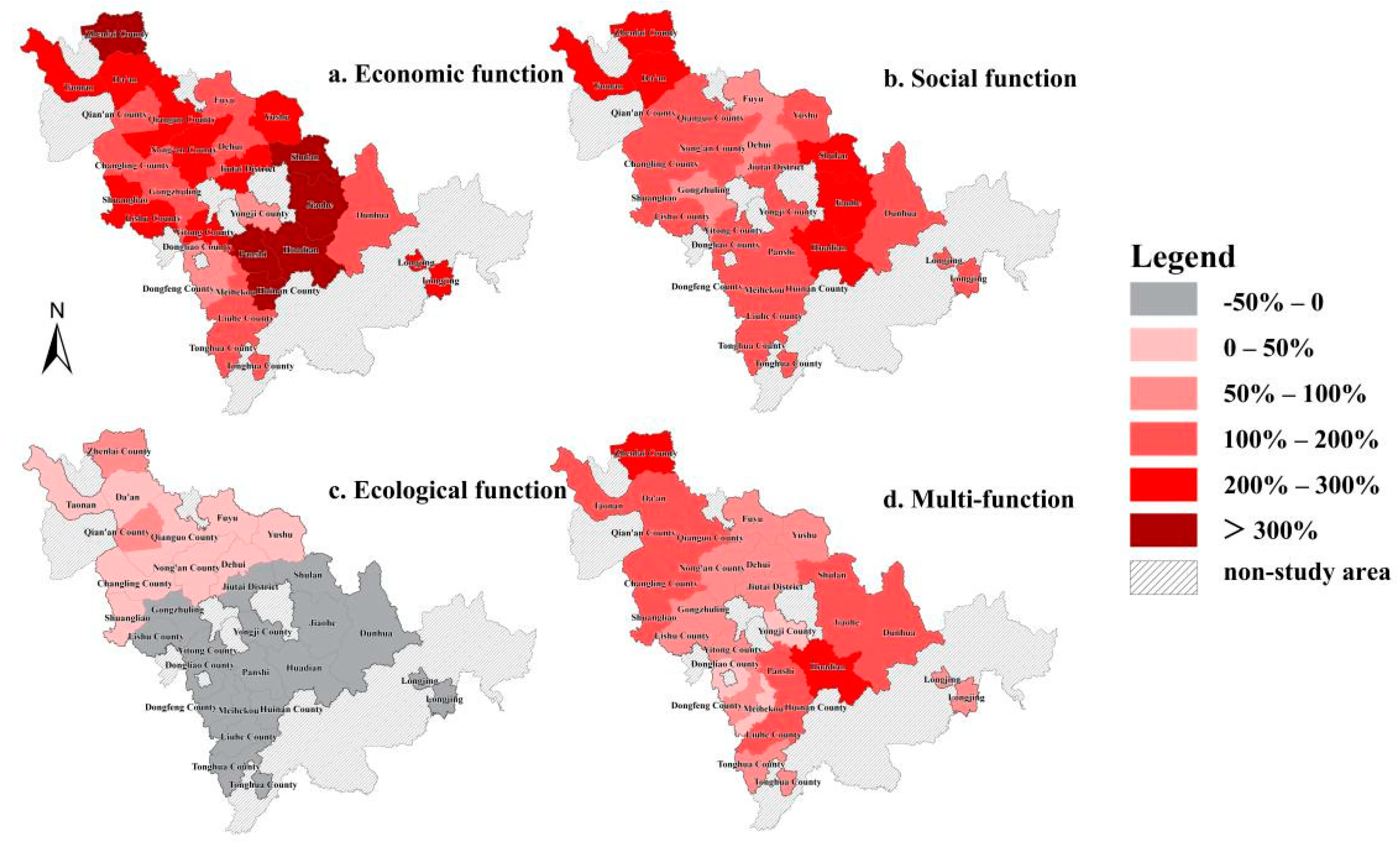
3.1.1. Temporal Variation in the Multi-Functionality of Cultivated Land
3.1.2. Spatial Variation and Differentiation in the Multi-Functionality of Cultivated Land
3.1.3. The Main Obstacles to Multi-Functionality of Cultivated Land
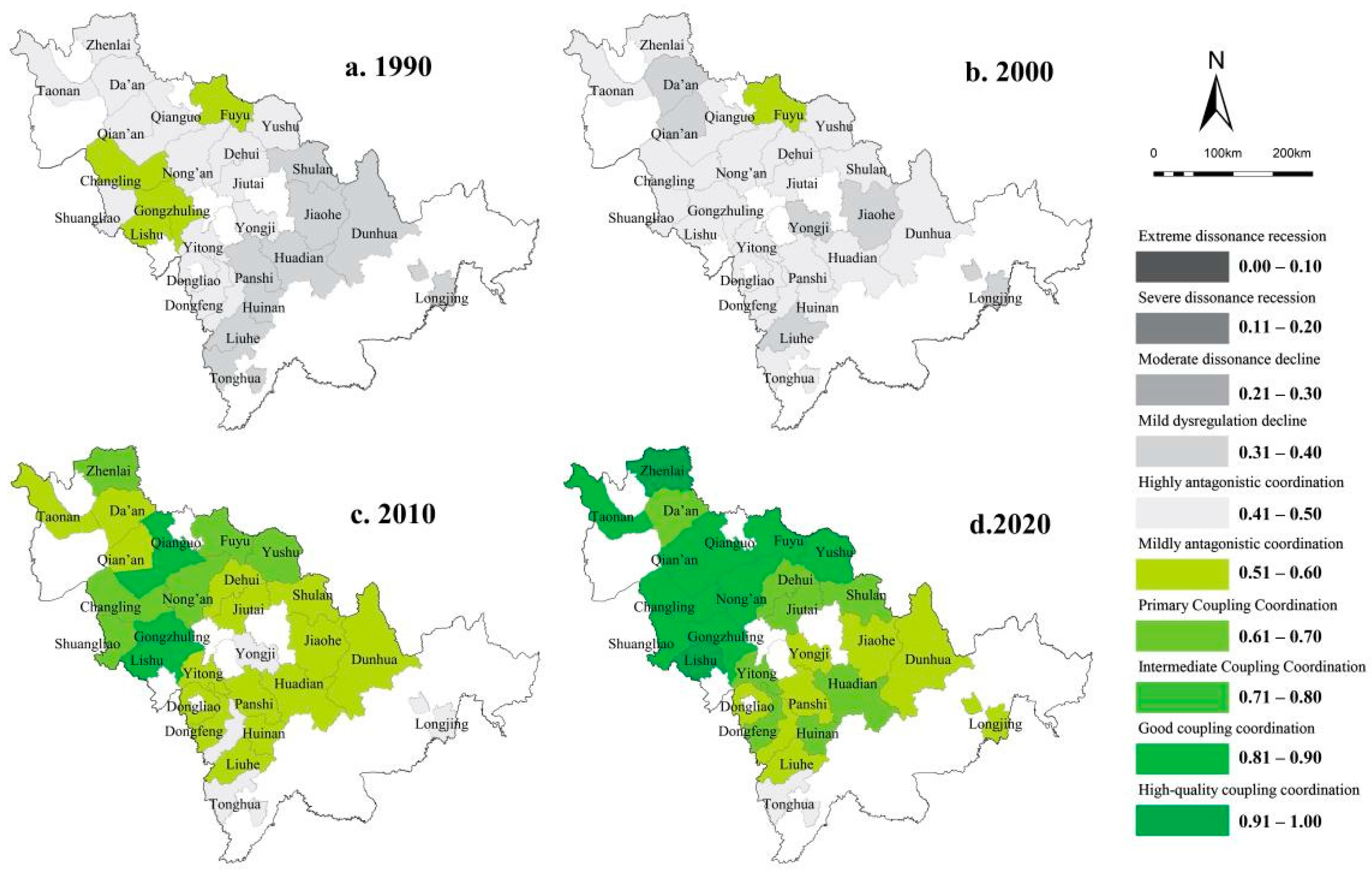
3.2. Coupling and Coordination Relationships among Various Sub-Functions of Cultivated Land
3.3. Key Factors Influencing the Multi-Functionality of Cultivated Land
4. Discussion
4.1. Policy Suggestions for Multi-Functional Management of Cultivated Land
4.2. Limitations and Future Research
5. Conclusions
Author Contributions
Funding
Institutional Review Board Statement
Informed Consent Statement
Data Availability Statement
Conflicts of Interest
References
- Yang, H.; Li, X.B. Cultivated land and food supply in China. Land Use Policy 2000, 17, 73–88. [Google Scholar] [CrossRef]
- Foley, J.A.; DeFries, R.; Asner, G.P.; Barford, C.; Bonan, G.; Carpenter, S.R.; Chapin, F.S.; Coe, M.T.; Daily, G.C.; Gibbs, H.K.; et al. Global consequences of land use. Science 2005, 309, 570–574. [Google Scholar] [CrossRef] [PubMed] [Green Version]
- Grafton, R.Q.; Daugbjerg, C.; Qureshi, M.E. Towards food security by 2050. Food Secur. 2015, 7, 179–183. [Google Scholar] [CrossRef]
- Marshall, E.J.R.; Moonen, A.C. Field margins in northern Europe: Their functions and interactions with agriculture. Agric. Ecosyst. Environ. 2002, 89, 5–21. [Google Scholar] [CrossRef]
- Granvik, M.; Lindberg, G.; Stigzelius, K.A.; Fahlbeck, E.; Surry, Y. Prospects of multifunctional agriculture as a facilitator of sustainable rural development: Swedish experience of Pillar 2 of the Common Agricultural Policy (CAP). Nor. Geogr. Tidsskr. 2012, 66, 155–166. [Google Scholar] [CrossRef]
- Zhang, R.; Zheng, H.; Liu, Y. Evaluation on cultivated land ecological security based on the PSR model and matter element analysis. Acta Ecol. Sin. 2013, 33, 5090–5100. [Google Scholar] [CrossRef]
- Lai, Z.H.; Chen, M.Q.; Liu, T.J. Changes in and prospects for cultivated land use since the reform and opening up in China. Land Use Policy 2020, 97, 104781. [Google Scholar] [CrossRef]
- Deng, X.Z.; Huang, J.K.; Rozelle, S.; Zhang, J.P.; Li, Z.H. Impact of urbanization on cultivated land changes in China. Land Use Policy 2015, 45, 1–7. [Google Scholar] [CrossRef]
- Su, Y.; Qian, K.; Lin, L.; Wang, K.; Guan, T.; Gan, M. Identifying the driving forces of non-grain production expansion in rural China and its implications for policies on cultivated land protection. Land Use Policy 2020, 92, 104435. [Google Scholar] [CrossRef]
- Lambin, E.F.; Gibbs, H.K.; Ferreira, L.; Grau, R.; Mayaux, P.; Meyfroidt, P.; Morton, D.C.; Rudel, T.K.; Gasparri, I.; Munger, J. Estimating the world’s potentially available cropland using a bottom-up approach. Glob. Environ. Chang. 2013, 23, 892–901. [Google Scholar] [CrossRef]
- Maes, J.; Egoh, B.; Willemen, L.; Liquete, C.; Vihervaara, P.; Schaegner, J.P.; Grizzetti, B.; Drakou, E.G.; La Notte, A.; Zulian, G.; et al. Mapping ecosystem services for policy support and decision making in the European Union. Ecosyst. Serv. 2012, 1, 31–39. [Google Scholar] [CrossRef]
- Saarikoski, H.; Primmer, E.; Saarela, S.-R.; Antunes, P.; Aszalos, R.; Baro, F.; Berry, P.; Garcia Blanko, G.; Gomez-Baggethun, E.; Carvalho, L.; et al. Institutional challenges in putting ecosystem service knowledge in practice. Ecosyst. Serv. 2018, 29, 579–598. [Google Scholar] [CrossRef]
- Peters, M.K.; Hemp, A.; Appelhans, T.; Becker, J.N.; Behler, C.; Classen, A.; Detsch, F.; Ensslin, A.; Ferger, S.W.; Frederiksen, S.B.; et al. Climate-land-use interactions shape tropical mountain biodiversity and ecosystem functions. Nature 2019, 568, 88–92. [Google Scholar] [CrossRef]
- Herath, G. Sustainable development of multifunctional landscapes. Ecol. Econ. 2004, 50, 319–321. [Google Scholar] [CrossRef]
- Wiggering, H.; Dalchow, C.; Glemnitz, M.; Helming, K.; Muller, K.; Schultz, A.; Stachow, U.; Zander, P. Indicators for multifunctional land use—Linking socio-economic requirements with landscape potentials. Ecol. Indic. 2006, 6, 238–249. [Google Scholar] [CrossRef]
- Costanza, R.; dArge, R.; deGroot, R.; Farber, S.; Grasso, M.; Hannon, B.; Limburg, K.; Naeem, S.; ONeill, R.V.; Paruelo, J.; et al. The value of the world’s ecosystem services and natural capital. Nature 1997, 387, 253–260. [Google Scholar] [CrossRef]
- Song, X.; Li, X. Theoretical explanation and case study of regional cultivated land use function transition. Acta Geogr. Sin. 2019, 74, 992–1010. [Google Scholar]
- Song, X.Q.; Ouyang, Z. Connotation of multifunctional cultivated land and its implications for cultivated land protection. Prog. Geogr. 2012, 31, 859–868. [Google Scholar]
- Sohl, T.L.; Sleeter, B.M.; Zhu, Z.; Sayler, K.L.; Bennett, S.; Bouchard, M.; Reker, R.; Hawbaker, T.; Wein, A.; Liu, S.; et al. A land-use and land-cover modeling strategy to support a national assessment of carbon stocks and fluxes. Appl. Geogr. 2012, 34, 111–124. [Google Scholar] [CrossRef]
- Chen, L.; Qu, F.T.; Shi, X.Y. The social value of cultivated land resources: A case in Liulin County of Shanxi Province. Resour. Sci. 2006, 28, 86–90. [Google Scholar]
- Li, D.; Ren, Z.; Liu, X.; Lin, Z. Dynamic change of ecological service value of cultivated land in Shaanxi Province. J. Arid. Land Resour. Environ. 2013, 7, 40–45. [Google Scholar]
- Zhu, P.X.; Bu, T.T.; Wu, Z.T. Study on compensation standard of land expropriation based on comprehensive value of cultivated land. China Popul. Rec. Environ. 2011, 09, 32–37. [Google Scholar]
- Liu, H.F.; Bi, R.T.; Guo, Y.L.; Wang, J. Protection zoning of cultivated land based on form-structure-function multidimensional evaluation system. Trans. Chin. Soc. Agric. Eng. 2021, 52, 168–177. [Google Scholar]
- Luo, C.; Cai, Y. The stage characteristics and spatial heterogeneity of cultivated land resource function evolution in agricultural producing areas of Hubei Province. Econ. Geogr. 2016, 36, 153–161. [Google Scholar]
- Yuan, H. A Study on cultivated land quality protection and agricultural sustainable development in the main grain producing areas of northeast China. Econo. Rev. 2017, 11, 106–111. [Google Scholar]
- Zhang, Y.; Long, H.; Ma, L.; Ge, D.; Tu, S.; Qu, Y. Farmland function evolution in the Huang-Huai-Hai Plain: Processes, patterns and mechanisms. J. Geogr. Sci. 2018, 28, 759–777. [Google Scholar] [CrossRef] [Green Version]
- Scown, M.W.; Winkler, K.J.; Nicholas, K.A. Aligning research with policy and practice for sustainable agricultural land systems in Europe. Proc. Natl. Acad. Sci. USA 2019, 116, 4911–4916. [Google Scholar] [CrossRef] [Green Version]
- Xia, H.; Zhang, W.S.; He, L.; Ma, M.Y.; Peng, H.; Li, L.; Ke, Q.; Hang, P.P.; Wang, X.T. Assessment on China’s urbanization after the implementation of main functional areas planning. J. Environ. Manag. 2020, 264, 110381. [Google Scholar] [CrossRef]
- Kang, R.; Ren, Y.; Wu, H.; Zhang, S. Changes in the nutrients and fertility of black soil over 26 years in Northeast China. Sci. Agric. Sin. 2016, 49, 2113–2125. [Google Scholar]
- Liu, X.B.; Zhang, X.Y.; Wang, Y.X.; Sui, Y.Y.; Zhang, S.L.; Herbert, S.J.; Ding, G. Soil degradation: A problem threatening the sustainable development of agriculture in Northeast China. Plant Soil Environ. 2010, 56, 87–97. [Google Scholar] [CrossRef] [Green Version]
- Jiang, G.H.; Wang, M.Z.; Qu, Y.B.; Zhou, D.Y.; Ma, W.Q. Towards cultivated land multifunction assessment in China: Applying the “influencing factors-functions-products-demands” integrated framework. Land Use Policy 2020, 99, 104982. [Google Scholar] [CrossRef]
- Tang, H.; Li, Z. Study on per capita grain demand based on Chinese reasonable dietary pattern. Sci. Agric. Sin. 2012, 45, 2315–2327. [Google Scholar]
- Li, T.; Zhang, F.; Hu, H. Authentication of the Kuznets Curve in agriculture non-point source pollution and its drivers analysis. China Popul. Resour. Environ. 2011, 21, 118–123. [Google Scholar]
- Xie, G.; Zhen, L.; Lu, C.X.; Xiao, Y.; Chen, C. Expert knowledge based valuation method of ecosystem services in China. J. Nat. Resour. 2008, 23, 911–919. [Google Scholar]
- Mir, M.A.; Ghazvinei, P.T.; Sulaiman, N.M.N.; Basri, N.E.A.; Saheri, S.; Mahmood, N.Z.; Jahan, A.; Begum, R.A.; Aghamohammadi, N. Application of TOPSIS and VIKOR improved versions in a multi criteria decision analysis to develop an optimized municipal solid waste management model. J. Environ. Manag. 2016, 166, 109–115. [Google Scholar]
- Xin, G.; Yang, C.; Yang, Q.; Li, C.; Wei, C. Post-evaluation of well-facilitied capital farmland construction based on entropy weight method and improved TOPSIS model. Trans. Chin. Soc. Agric. Eng. 2017, 33, 238–249. [Google Scholar]
- Zhang, H.; Feng, S.; Qu, F. Research on coupling coordination among cultivated land protection, construction land intensive use and urbanization. J. Nat. Resour. 2017, 32, 1002–1015. [Google Scholar]
- Wang, J.F.; Zhang, T.L.; Fu, B.J. A measure of spatial stratified heterogeneity. Ecol. Indic. 2016, 67, 250–256. [Google Scholar] [CrossRef]
- Wang, J.; Xu, C. Geodetector: Principle and prospective. Acta Geogr. Sin. 2017, 72, 116–134. [Google Scholar]
- Wang, S.; Kong, W.; Ren, L.; Zhi, D.; Dai, B. Research on misuses and modification of coupling coordination degree model in China. J. Nat. Resour. 2021, 36, 793–810. [Google Scholar] [CrossRef]
- Gonzalez-Garcia, A.; Palomo, I.; Gonzalez, J.A.; Lopez, C.A.; Montes, C. Quantifying spatial supply-demand mismatches in ecosystem services provides insights for land-use planning. Land Use Policy 2020, 94, 104493. [Google Scholar] [CrossRef]
- Pierce, S.M.; Cowling, R.M.; Knight, A.T.; Lombard, A.T.; Rouget, M.; Wolf, T. Systematic conservation planning products for land-use planning: Interpretation for implementation. Biol. Conserv. 2005, 125, 441–458. [Google Scholar] [CrossRef]
- Zhai, W.; Huang, X. Analysis on the effect of policies operation of cultivated land protection in China. China Land Sci. 2003, 17, 8–13. [Google Scholar]
- Smith, P. Delivering food security without increasing pressure on land Pete Smith. Glob. Food Secur. 2013, 2, 18–23. [Google Scholar] [CrossRef]
- Xu, X.L.; Wang, L.; Cai, H.Y.; Wang, L.Y.; Liu, L.; Wang, H.Z. The influences of spatiotemporal change of cultivated land on food crop production potential in China. Food Secur. 2017, 9, 485–495. [Google Scholar] [CrossRef]
- Qi, X.; Li, J.; Yuan, W.; Wang, R.Y. Coordinating the food-energy-water nexus in grain production in the context of rural livelihood transitions and farmland resource constraints. Resour. Conserv. Recycl. 2021, 164, 105148. [Google Scholar] [CrossRef]
- Wang, Q.; Lang, H.; Zhong, J.; Chen, M.; Zhang, B.; Zeng, S. Progress review on land science research in 2021 and prospects for 2022. China Land Sci. 2022, 36, 104–115. [Google Scholar]
- Alizamir, S.; Iravani, F.; Mamani, F. An Analysis of Price vs. Revenue Protection: Government Subsidies in the Agriculture Industry. Manage. Sci. 2019, 65, 32–49. [Google Scholar] [CrossRef] [Green Version]
- Cao, Z.; Hao, J.; Liang, L. The value accounting of cultivated land resources in Huang—Huai—Hai Region. J. Arid Land Resour. Environ. 2009, 9, 5–10. [Google Scholar]
- Ellis, E.C. Land Use and Ecological Change: A 12,000-Year History. Annu. Rev. Environ. Resour. 2021, 46, 1–33. [Google Scholar] [CrossRef]
- Wang, Q.; Jin, X.B.; Zhou, Y.K. Cultivated land ecological security and spatial aggregation pattern in Hebei Province. Trans. Chin. Soc. Agric. Eng. 2011, 27, 338–344. [Google Scholar]
- Huang, J.; Yu, H.; Han, D.; Zhang, G.; Wei, Y.; Huang, J.; An, L.; Liu, X.; Ren, Y. Declines in global ecological security under climate change. Ecol. Indic. 2020, 117, 106651. [Google Scholar] [CrossRef]
- Burger, J.R.; Allen, C.D.; Brown, J.H.; Burnside, W.R.; Davidson, A.D.; Fristoe, T.S.; Hamilton, M.J.; Mercado-Silva, N.; Nekola, J.C.; Okie, J.G.; et al. The Macroecology of Sustainability. PLoS Biol. 2012, 10, e1001345. [Google Scholar] [CrossRef] [PubMed]
- Bongaarts, J. Summary for policymakers of the global assessment report on biodiversity and ecosystem services of the Intergovernmental Science-Policy Platform on Biodiversity and Ecosystem Services. Popul. Dev. Rev. 2019, 45, 680–681. [Google Scholar] [CrossRef] [Green Version]
- Peng, J.; Liu, Z.C.; Liu, Y.X.; Hu, X.X.; Wang, A. Multifunctionality assessment of urban agriculture in Beijing City, China. Sci. Total Environ. 2015, 537, 343–351. [Google Scholar] [CrossRef] [PubMed]
- Zhang, D.; Ng, E.L.; Hu, W.L.; Wang, H.Y.; Galaviz, P.; Yang, H.D.; Sun, W.T.; Li, C.X.; Ma, X.W.; Fu, B.; et al. Plastic pollution in croplands threatens long-term food security. Glob. Chang. Biol. 2020, 26, 3356–3367. [Google Scholar] [CrossRef]


| Data Type | Data Source | Time Series | Resolution |
|---|---|---|---|
| Land use/land cover | Resource and Environment Science Data Center, Chinese Academy of Sciences | 1990, 2000, 2010, 2020 | 30 m × 30 m |
| River and road data | Extracted from land-use and -cover data from Data Center for Resources and Environmental Sciences, Chinese Academy of Sciences | 1990, 2000, 2010, 2020 | Same as land-use/land-cover data |
| Digital elevation model (DEM) | Geospatial Data Cloud (http://www.gscloud.cn/, accessed on 21 December 2021) | 2009 | 30 m × 30 m |
| Slope | Calculated from DEM data | 2009 | 30 m × 30 m |
| Meteorological | Meteorological Data Center, China Meteorological Administration | 1990, 2000, 2010, 2020 | Site |
| Socioeconomic | Jilin and counties (cities) statistical yearbooks | 1990, 2000, 2010, 2020 | County level |
| Agricultural | Jilin rural statistical yearbooks | 1990, 2000, 2010, 2020 | County level |
| Cultivated-land quality | Agricultural-land grading and projections | 2009, 2019 | 1:100,000 |
| Function | Indicator | Calculation Method | Unit | Trend | Weight |
|---|---|---|---|---|---|
| Economic | Average grain output | Grain production/Cultivated-land area | kg/hm2 | Positive | 0.0422 |
| Average output of cultivated land | Output value of primary industry/Cultivated-land area | Ten thousand CNY/hm2 | Positive | 0.1034 | |
| Percentage of cultivated-land value | Gross plantation output/Gross regional product | Dimensionless | Positive | 0.0701 | |
| Agricultural-labor productivity | Output value of primary industry/Employees of primary industry | CNY/person | Positive | 0.1003 | |
| Per capita agricultural output | Gross agricultural output/Total population | CNY/person | Positive | 0.1208 | |
| Social | Per capita cultivated land | Cultivated-land area/Total population | hm2/person | Positive | 0.0394 |
| Grain commodification index | Grain production/(Per capita grain demand × Population) | Dimensionless | Positive | 0.078 | |
| Per capita grain production | Total grain production/Total population | kg/person | Positive | 0.078 | |
| Degree of agricultural mechanization | Total power of agricultural machinery/Cultivated-land area | kW/hm2 | Negative | 0.0976 | |
| Labor-transfer index | Non-agricultural population/Total population | Dimensionless | Positive | 0.0284 | |
| Ecological | Fertilizer-use-intensity index | The total amount of fertilizer applied on the ground/Safety standard for fertilizer use | Dimensionless | Negative | 0.013 |
| Production-value energy consumption | Agricultural electricity consumption/Gross agricultural output value | kW/CNY 10,000 | Negative | 0.007 | |
| Effective-irrigation index | Effective irrigated cultivated-land area/Cultivated-land area | Dimensionless | Positive | 0.0689 | |
| Fragmentation of cultivated land | Parameter calculation | Dimensionless | Negative | 0.0306 | |
| Proportional ecological value of cultivated land | Ecological service value of cultivated-land area/Ecological service value of total land area | Dimensionless | Positive | 0.0737 | |
| Land-reclamation coefficient | Cultivated-land area/Total land area | Dimensionless | Positive | 0.0486 |
| Factor | Indicator | Abbreviation | Calculation |
|---|---|---|---|
| Physical geography | Elevation | Elevation | Elevation values from DEM |
| Slope | slope | The actual slope of the cultivated land | |
| Annual precipitation | annual precipitation | Regional averages from weather-station data | |
| Distance from major rivers | DFMR | Euclidean distance based on the distribution of the water system | |
| Cultivated-land quality | cultivated-land quality | Agricultural-land grading | |
| Distance from provincial capital | DFPC | Distance from the main city of Changchun | |
| Distance from central city | DFCC | Distance from the main city of the prefecture-level city | |
| Economic development | Per capita GDP | GDP per capita | Total GDP/Total population |
| Per capita agricultural output of farmers | PCAOVF | Output value of primary industry/Rural population | |
| Proportion of secondary and tertiary industries | PSTI | Output value of secondary and tertiary industries/Total GDP | |
| Fixed asset investment per land | FAIPL | Total fixed asset investment/Regional land area | |
| Urban construction | Urbanization rate | urbanization rate | Urban population/Total population |
| Population density | Population density | Total population/Regional land area | |
| Percentage of built-up area | PBA | Built-up area/Total land area | |
| Road-network density | road network density | Proportion of road-network length to total area | |
| Policy | Agricultural policy division | APD | Permanent basic farmland, prohibited construction areas, restricted construction areas, conditional construction areas, permitted construction areas |
| Construction-land-index pressure | CLIP | Rural per capita construction land/Rural construction land standard + Urban per capita construction land/Urban per capita land standard | |
| Proportion of financial support to agriculture | PFFSA | Proportion of expenditure on agriculture, forestry, and water affairs in public finance |
| Function | Score | Change (%) | CV | |||||||||
|---|---|---|---|---|---|---|---|---|---|---|---|---|
| 1990 | 2000 | 2010 | 2020 | 1990–2000 | 2000–2010 | 2010–2020 | 1990–2020 | 1990 | 2000 | 2010 | 2020 | |
| Economic | 0.148 | 0.148 | 0.359 | 0.484 | 0.24% | 142.51% | 34.73% | 227.51% | 0.267 | 0.265 | 0.310 | 0.252 |
| Social | 0.159 | 0.165 | 0.289 | 0.401 | 3.75% | 75.27% | 38.96% | 152.69% | 0.338 | 0.309 | 0.343 | 0.332 |
| Ecological | 0.441 | 0.451 | 0.459 | 0.456 | 2.16% | 1.76% | −0.52% | 3.41% | 0.368 | 0.393 | 0.430 | 0.450 |
| Multi | 0.222 | 0.227 | 0.361 | 0.451 | 1.97% | 59.08% | 24.97% | 102.72% | 0.300 | 0.212 | 0.290 | 0.283 |
| Year | Item | Function Order | Index Order | ||||||
|---|---|---|---|---|---|---|---|---|---|
| 1 | 2 | 3 | 1 | 2 | 3 | 4 | 5 | ||
| 1990 | Barrier indicator | Economic function | Social function | Ecological function | PCAO | AOV | ALP | DAM | FCI |
| Handicap | 13.46 | 9.76 | 4.78 | 4.29 | 3.64 | 3.55 | 3.42 | 2.36 | |
| 2000 | Barrier indicator | Economic function | Social function | Ecological function | PCAO | AOV | DAM | ALP | FCI |
| Handicap | 13.51 | 9.75 | 4.74 | 4.11 | 3.22 | 3.21 | 3.00 | 2.53 | |
| 2010 | Barrier indicator | Economic function | Social function | Ecological function | PCAO | DAM | PCLV | AOV | FCI |
| Handicap | 12.31 | 10.09 | 5.60 | 3.87 | 3.67 | 2.77 | 2.60 | 2.29 | |
| 2020 | Barrier indicator | Economic function | Social function | Ecological function | PCAO | DAM | PCLV | EII | AOV |
| Handicap | 11.56 | 9.88 | 6.56 | 3.63 | 3.60 | 3.02 | 2.50 | 2.30 | |
| Whole period | Barrier indicator | Economic function | Social function | Ecological function | PCAO | DAM | AOV | ALP | FCI |
| Handicap | 50.84 | 39.49 | 21.68 | 15.90 | 13.90 | 11.76 | 10.30 | 9.35 | |
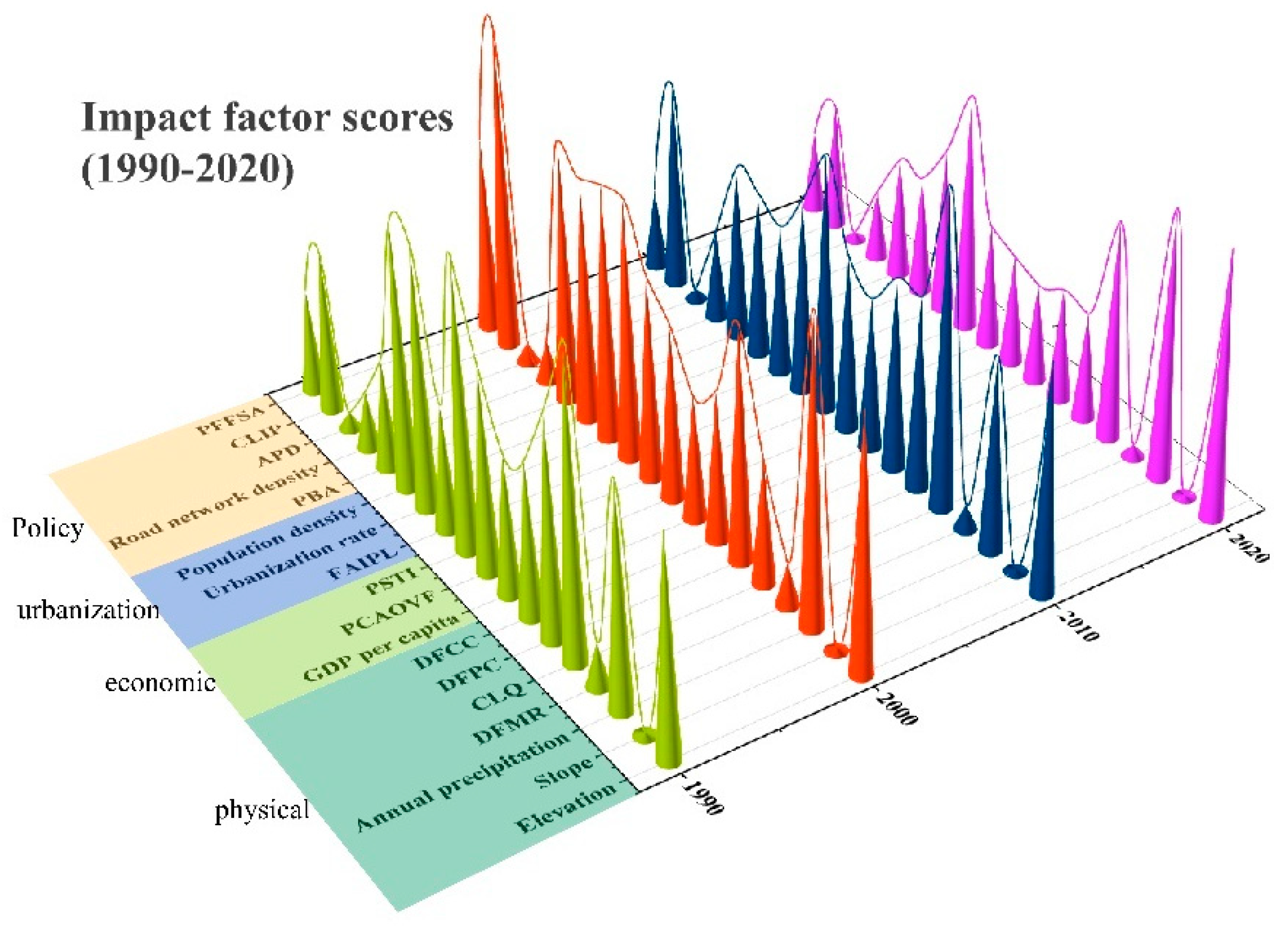
| Factor | Indicator | 1990 | 2000 | 2010 | 2020 | Average |
|---|---|---|---|---|---|---|
| Physical geography | Elevation | 0.54 | 0.62 | 0.56 | 0.65 | 0.59 |
| Slope | 0.01 | 0.01 | 0.01 | 0.00 | 0.01 | |
| Annual precipitation | 0.55 | 0.75 | 0.48 | 0.66 | 0.61 | |
| Distance from major rivers | 0.11 | 0.11 | 0.06 | 0.03 | 0.08 | |
| Cultivated-land quality | 0.76 | 0.31 | 0.78 | 0.54 | 0.59 | |
| Distance from provincial capital | 0.54 | 0.57 | 0.47 | 0.26 | 0.46 | |
| Distance from central city | 0.38 | 0.37 | 0.47 | 0.28 | 0.37 | |
| Subtotal | 2.88 | 2.73 | 2.81 | 2.42 | 2.71 | |
| Economic development | Per capita GDP | 0.34 | 0.31 | 0.37 | 0.24 | 0.32 |
| Per capita agricultural output of farmers | 0.50 | 0.43 | 0.43 | 0.27 | 0.41 | |
| Proportion of secondary and tertiary industries | 0.71 | 0.50 | 0.63 | 0.30 | 0.53 | |
| Subtotal | 1.55 | 1.23 | 1.44 | 0.81 | 1.26 | |
| Urban construction | Fixed asset investment per land | 0.31 | 0.64 | 0.48 | 0.59 | 0.50 |
| Urbanization rate | 0.64 | 0.63 | 0.37 | 0.41 | 0.51 | |
| Population density | 0.65 | 0.60 | 0.41 | 0.29 | 0.49 | |
| Subtotal | 1.60 | 1.86 | 1.26 | 1.29 | 1.50 | |
| Policy | Percentage of built-up area | 0.27 | 0.65 | 0.43 | 0.30 | 0.41 |
| Road-network density | 0.14 | 0.10 | 0.22 | 0.17 | 0.16 | |
| Agricultural-policy division | 0.04 | 0.05 | 0.03 | 0.02 | 0.03 | |
| Construction-land-pressure index | 0.40 | 0.79 | 0.51 | 0.31 | 0.50 | |
| Proportion of financial support to agriculture | 0.26 | 0.48 | 0.20 | 0.20 | 0.28 | |
| Subtotal | 1.11 | 2.07 | 1.39 | 1.00 | 1.39 |
Publisher’s Note: MDPI stays neutral with regard to jurisdictional claims in published maps and institutional affiliations. |
© 2022 by the authors. Licensee MDPI, Basel, Switzerland. This article is an open access article distributed under the terms and conditions of the Creative Commons Attribution (CC BY) license (https://creativecommons.org/licenses/by/4.0/).
Share and Cite
Gong, H.; Zhao, Z.; Chang, L.; Li, G.; Li, Y.; Li, Y. Spatiotemporal Patterns in and Key Influences on Cultivated-Land Multi-Functionality in Northeast China’s Black-Soil Region. Land 2022, 11, 1101. https://doi.org/10.3390/land11071101
Gong H, Zhao Z, Chang L, Li G, Li Y, Li Y. Spatiotemporal Patterns in and Key Influences on Cultivated-Land Multi-Functionality in Northeast China’s Black-Soil Region. Land. 2022; 11(7):1101. https://doi.org/10.3390/land11071101
Chicago/Turabian StyleGong, Heyang, Zhibo Zhao, Lei Chang, Guanghui Li, Ying Li, and Yuefen Li. 2022. "Spatiotemporal Patterns in and Key Influences on Cultivated-Land Multi-Functionality in Northeast China’s Black-Soil Region" Land 11, no. 7: 1101. https://doi.org/10.3390/land11071101