
Methodology for Identifying Ecological Corridors: A Spatial Planning Perspective


Abstract
:1. Introduction
2. Materials and Methods
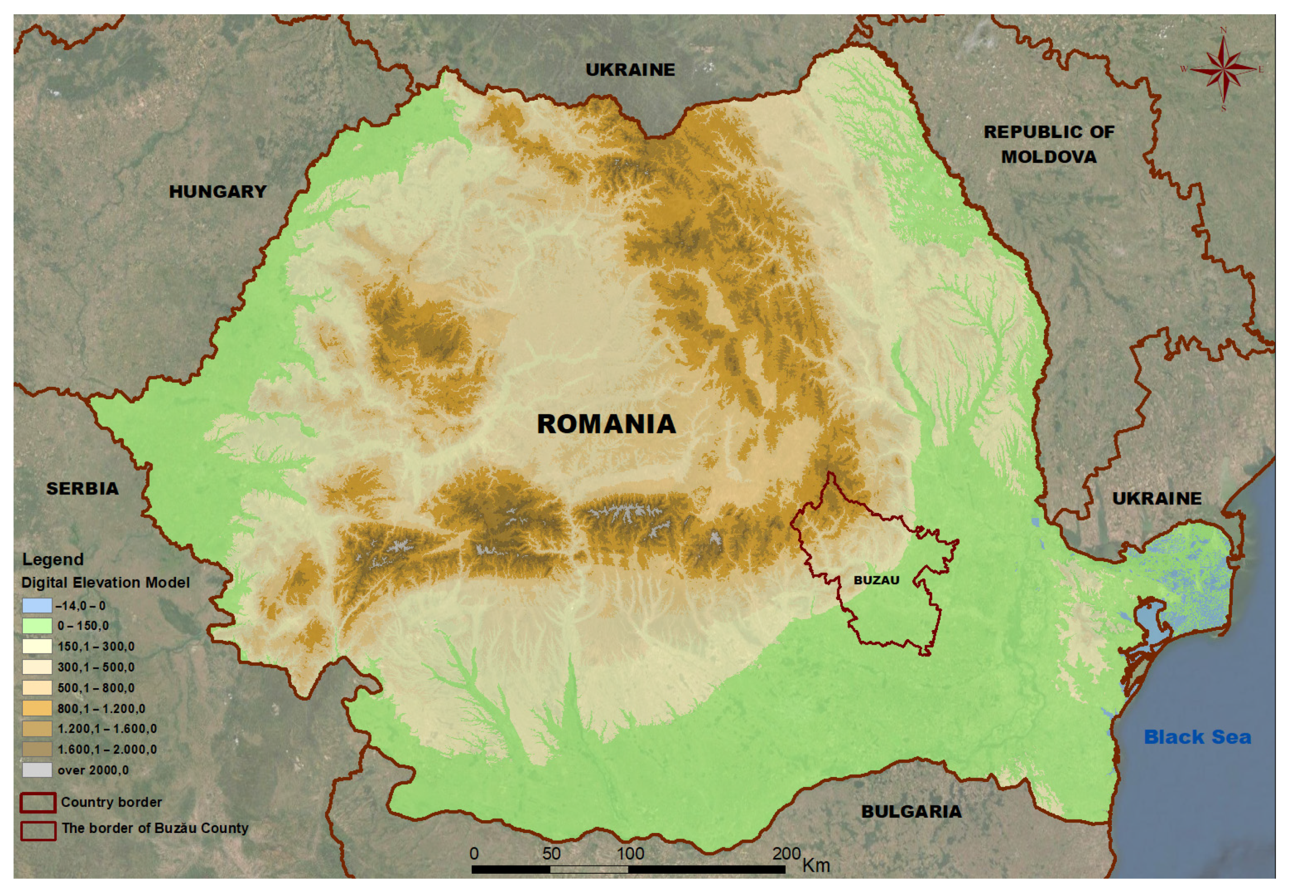
2.1. Study Area
2.2. Main Steps of the Methodology
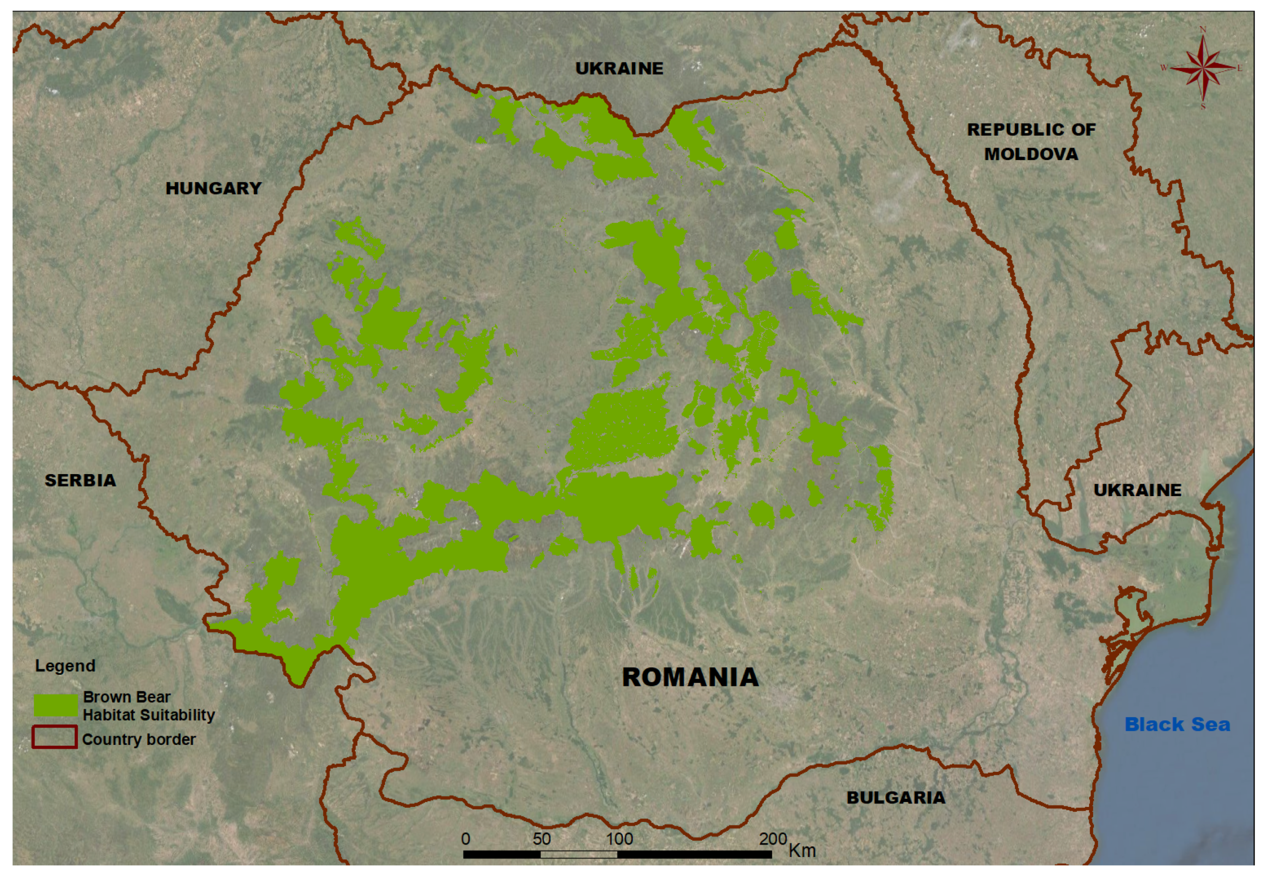
- Step 1: Brown bear habitat suitability model: allows the identification of core areas and stepping stones that ensure the living and moving conditions of brown bear;
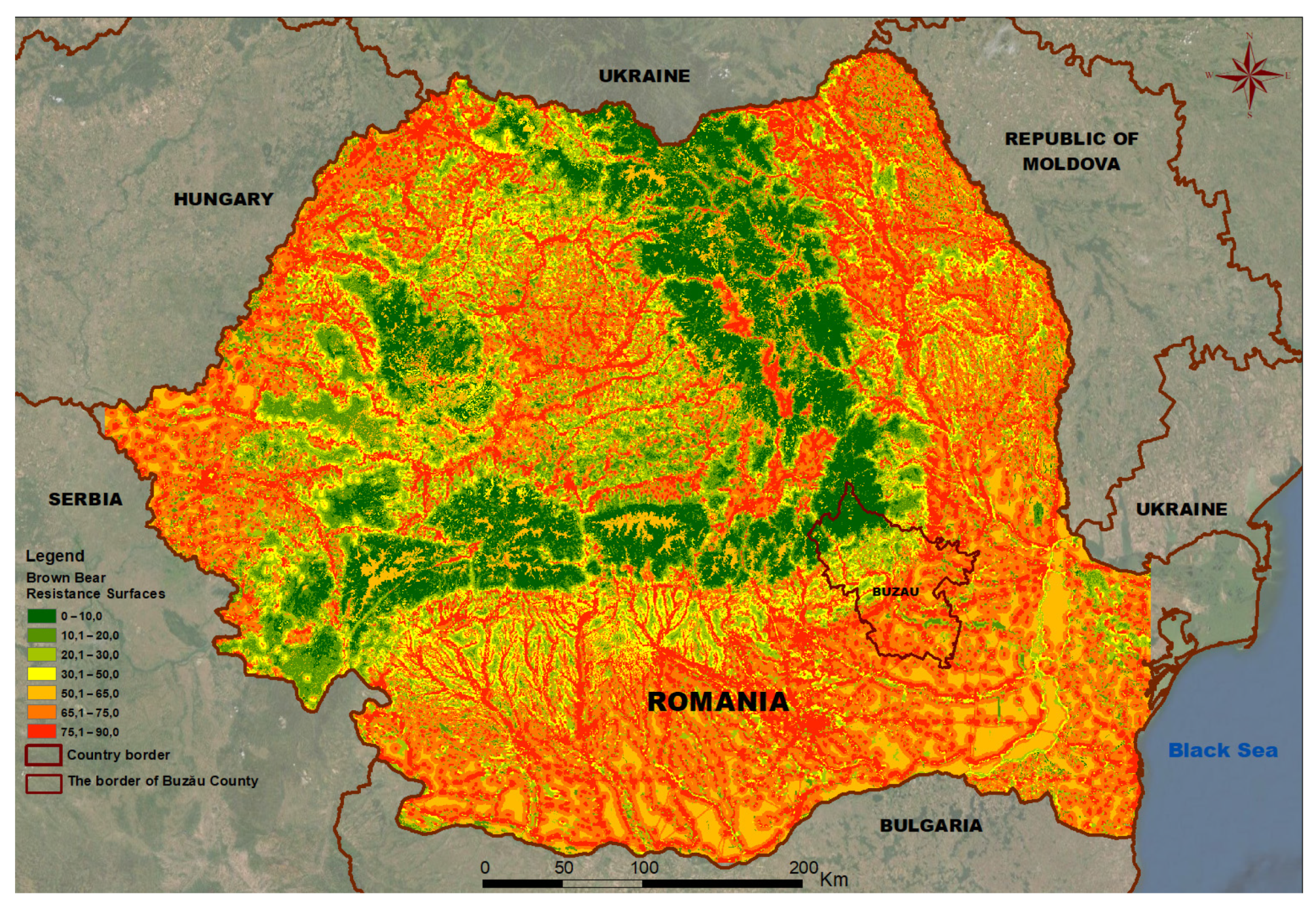
- Step 2: Connectivity model: ensures the interconnection of favorable habitats through corridors creating a coherent network. It establishes and adds resistance surfaces, consisting of linear elements that create barriers in the movement of the brown bear (such as settlements, road infrastructure);
- Step 3: Identification of ecological networks and corridors for the brown bear species at a national and county level, identification of critical areas according to the working scale.
2.2.1. The National Scale
2.2.2. The County Scale
3. Results
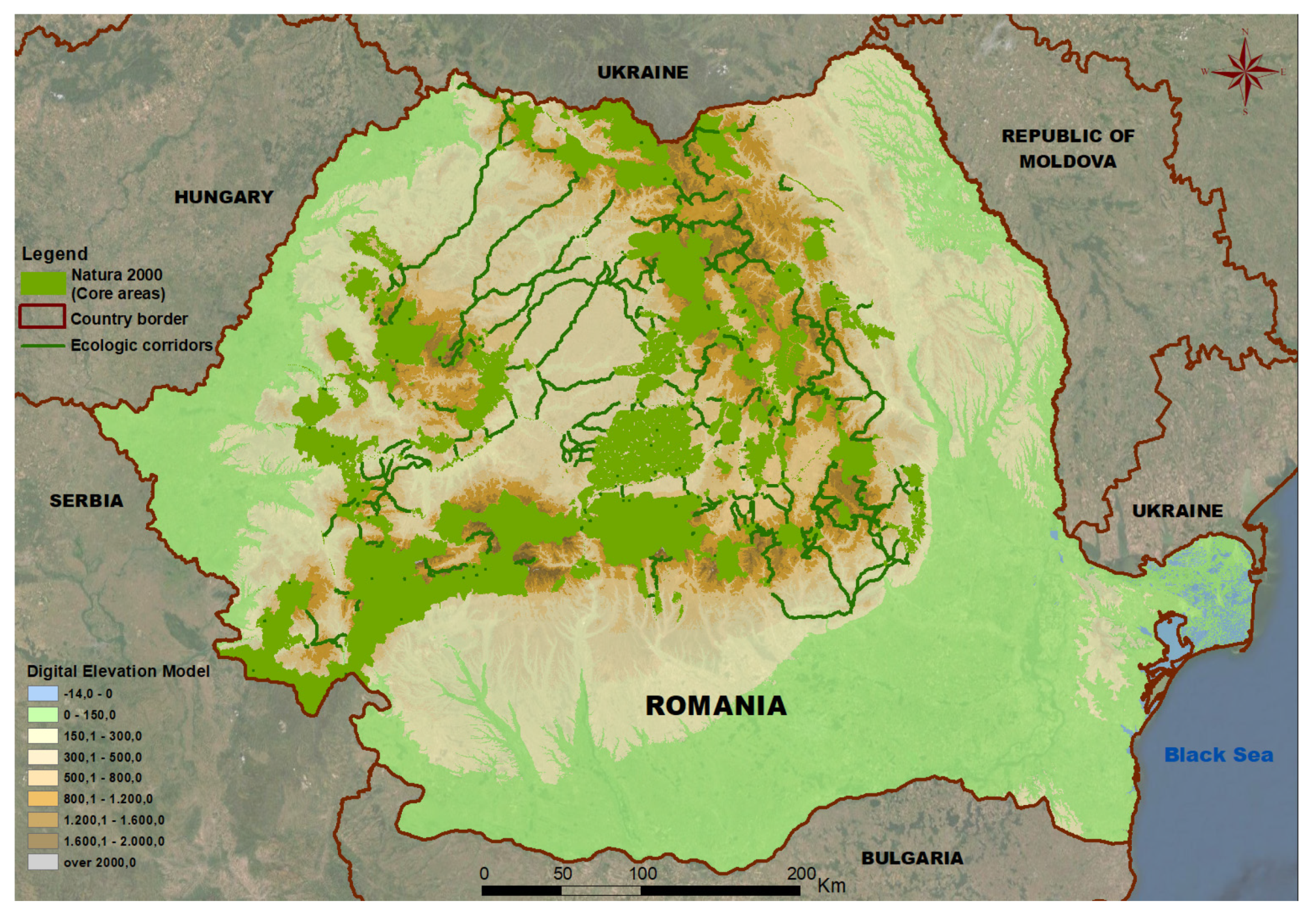
3.1. Map of Ecological Networks for the Brown Bear at the National Level
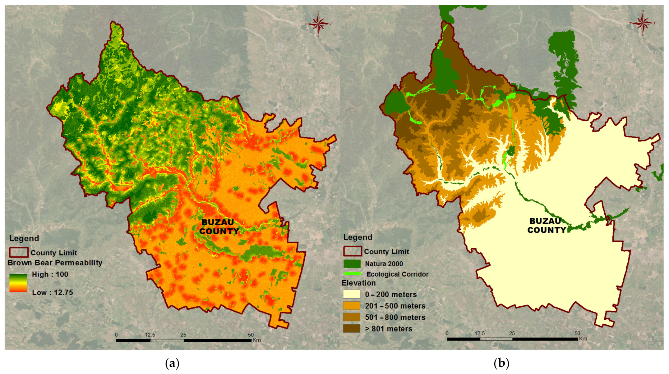
3.2. Map of Potential Ecological Corridors for the Brown Bear at County Level
4. Discussion
4.1. Validation of Results
4.2. Comparison with Other Identified Ecological Networks-TSES Network
4.3. Advantages of the Methodology and Contribution in the Field
4.4. Methodological Limitations
- Scale
- Restrictions on ecological corridors
- Legislative changes
4.5. Directions for Further Research: Implementing Identified Ecological Corridors in Spatial and Urban Planning Documentation
- Implementation of ecological corridors in spatial planning documents
- Implementation of ecological corridors in urban planning documents
5. Conclusions
Author Contributions
Funding
Institutional Review Board Statement
Informed Consent Statement
Data Availability Statement
Acknowledgments
Conflicts of Interest
References
- Bennett, A.F. Habitat corridors and the conservation of small mammals in a fragmented forest environment. Landsc. Ecol. 1990, 4, 109–122. [Google Scholar] [CrossRef]
- Batistella, M.; Brondizio, E.S.; Moran, E.F. Comparative analysis of landscape fragmentation in Rondônia, Brazilian Amazon. Int. Arch. Photogramm. Remote Sens. 2000, 33, 148–155. [Google Scholar]
- Kindlmann, P.; Burel, F. Connectivity measures: A review. Landsc. Ecol. 2008, 23, 879–890. [Google Scholar] [CrossRef] [Green Version]
- World Economic Forum. Nature Risk Rising: Why the Crisis Engulfing Nature Matters for Business and the Economy. 2020. Available online: https://www.weforum.org/reports/nature-risk-rising-why-the-crisis-engulfing-nature-matters-for-business-and-the-economy (accessed on 10 August 2021).
- Smeraldo, S.; Bosso, L.; Fraissinet, M.; Bordignon, L.; Brunelli, M.; Ancillotto, L.; Russo, D. Modelling risks posed by wind turbines and power lines to soaring birds: The black stork (Ciconia nigra) in Italy as a case study. Biodivers. Conserv. 2020, 29, 1959–1976. [Google Scholar] [CrossRef]
- Nadal, J.; Sáez, D.; Margali, A. Crossing artificial obstacles during migration: The relative global ecological risks and interdependencies illustrated by the migration of common quail Coturnix coturnix. Sci. Total Environ. 2022, 808, 152173. [Google Scholar] [CrossRef]
- Carroll, C.; Dunk, J.R.; Moilanen, A. Optimizing resiliency of reserve networks to climate change: Multispecies conservation planning in the Pacific Northwest. Glob. Chang. Biol. 2010, 16, 891–904. [Google Scholar] [CrossRef] [Green Version]
- Spring, D.; Baum, J.; Nally, R.M.; MacKenzie, M.; Sanchez-Azofeifa, A.; Thomson, J.R. Building a regionally connected reserve network in a changing and uncertain world. Conserv. Biol. 2010, 24, 691–700. [Google Scholar] [CrossRef]
- Hehl-Lange, S. Structural elements of the visual landscape and their ecological functions. Landsc. Urban Plan. 2001, 54, 107–115. [Google Scholar] [CrossRef]
- Convention on the Conservation of Migratory Species of Wild Animals. Bonn, Germany, 23 June 1979. Available online: https://www.cms.int/en/convention-text (accessed on 28 April 2022).
- Guidelines for Conserving Connectivity through Ecological Networks and Corridors. IUCN WCPA’s Best Practice Protected Area Guidelines Series. 2020. Available online: https://portals.iucn.org/library/node/49061 (accessed on 28 April 2022).
- Global Assessment Report on Biodiversity and Ecosystem Services. IPBES. 2019. Available online: https://ipbes.net/global-assessment (accessed on 18 April 2022).
- Bennett, G. Integrating Biodiversity Conservation and Sustainable Use: Lessons Learned from Ecological Networks; IUCN: Gland, Switzerland; Cambridge, UK, 2004; p. 6. [Google Scholar]
- Bennett, G.; Mulongoy, K.J. Review of Experience with Ecological Network Corridors, Corridors and Buffer Zones; Technical Series No. 23; Secretariat of the Convention on Biological Diversity: Montreal, QC, Canada, 2006; p. 4. [Google Scholar]
- MacArthur, R.H.; Wilson, E.O. The theory of island biogeography. In The Theory of Island Biogeography; Princeton University Press: Princeton, NJ, USA, 2016. [Google Scholar]
- Levins, R. Some demographic and genetic consequences of environmental heterogeneity for biological control. Bull. Èntomol. Soc. Am. 1969, 15, 237–240. [Google Scholar] [CrossRef]
- Hanski, I. Spatially realistic theory of metapopulation ecology. Naturwissenschaften 2001, 88, 372–381. [Google Scholar] [CrossRef]
- Bennett, G.; Wit, P. The Development and Application of Ecological Networks: A Review of Proposals, Plans and Programmes; IUCN: Gland, Switzerland; AIDEnvironment: Amsterdam, The Netherlands, 2001; p. 5. [Google Scholar]
- CONNECTGREEN: Restoring and Managing Ecological Corridors in Mountains as the Green Infrastructure in the Danube Basin. Available online: https://www.interreg-danube.eu/approved-projects/connectgreen/outputs (accessed on 20 January 2022).
- Forman, R.T.; Godron, M. Patches and structural components for a landscape ecology. BioScience 1981, 31, 733–740. [Google Scholar]
- EU Biodiversity Strategy for 2030: Bringing Nature Back into Our Lives. Available online: https://eur-lex.europa.eu/legal-content/EN/TXT/?uri=CELEX:52020DC0380 (accessed on 28 April 2022).
- Regulation (EU) 2021/783 of the European Parliament and the Council of 29 April 2021 establishing a Programme for the Environment and Climate Action (LIFE), and repealing Regulation (EU) No 1293/2013. Available online: https://eur-lex.europa.eu/legal-content/EN/TXT/?uri=uriserv%3AOJ.L_.2021.172.01.0053.01.ENG&toc=OJ%3AL%3A2021%3A172%3ATOC (accessed on 28 April 2022).
- Popescu, O.-C.; Petrișor, A.-I. Green Infrastructure and Spatial Planning: A legal framework. Oltenia. Stud. Şi Comunicări. Ştiinţele Nat. 2021, 37, 217–224. [Google Scholar]
- Territorial Agenda of the European Union 2020. Towards an Inclusive, Smart and Sustainable Europe of Diverse Regions, Agreed at the Informal Ministerial Meeting Responsible for Spatial Planning and Territorial Development, Gödöllő, Hungary, 19 May 2011. Available online: https://ec.europa.eu/regional_policy/sources/policy/what/territorial-cohesion/territorial_agenda_2020.pdf (accessed on 28 April 2022).
- Resolution No. 1 on Rational Use of Land: The Basis and Limiting Factor of Our Development. In Proceedings of the 8th European Conference of Ministers responsible for Regional Planning (CEMAT), Lausanne, Switzerland, 20–23 October 1988; Available online: https://rm.coe.int/8th-european-conference-of-ministers-responsible-for-regional-planning/168076cf80 (accessed on 29 April 2022).
- Perrin, M.; Bertrand, N.; Kohler, Y. PLACE Report: Spatial Planning and Ecological Connectivity—An Analytical Overview across the Alpine Convention Area; Grenoble: Irstea, with the contribution of the Platform Ecological Network of the Alpine Convention and ALPARC, and the support of the French Ministry for the Ecological and Inclusive Transition (MTES); Irstea: Grenoble, France, 2019; pp. 20–42. [Google Scholar]
- Adriaensen, F.; Chardon, J.P.; De Blust, G.; Swinnen, E.; Villaba, S.; Gulinck, H.; Matthysen, E. The application of ‘least-cost’ modelling as a functional landscape model. Landsc. Urban Plan. 2003, 64, 233–247. [Google Scholar] [CrossRef]
- Hilty, J.A.; Lidicker, W.Z.; Merenlender, A.M. Corridor Ecology: The Science and Practice of Linking Landscapes for Biodiversity Conservation; Island Press: Washington, DC, USA, 2006; pp. 209–253. [Google Scholar]
- Kabir, M.; Hameed, S.; Ali, H.; Bosso, L.; Ud Din, J.; Bischof, R.; Redpath, S.; Nawaz, M.A. Habitat suitability and movement corridors of grey wolf (Canis lupus) in Northern Pakistan. PLoS ONE 2017, 12, e0187027. [Google Scholar] [CrossRef] [Green Version]
- Popescu, O.-C.; Tache, A.-V.; Petrisor, A.-I. Methodology for identifying the ecological corridors. Case study: Planning for the brown bear corridors in the Romanian Carpathians. In Proceedings of the ICSD 2020, Online Conference, New York, NY, USA, 21–22 September 2020; Available online: https://ic-sd.org/wp-content/uploads/2020/11/Alexandru-Ionut-Petrisor.pdf (accessed on 5 May 2022).
- Tache, A.-V.; Popescu, O.-C.; Petrişor, A.-I. Evaluarea potenţialelor coridoare ecologice pentru specia de urs brun la nivelul României/Finding the potential ecological corridors for the brown bear in Romania. Revista Școlii. Doctorale de Urbanism 2020, 5, 37–48. [Google Scholar]
- Deodatus, F.; Kruhlov, I.; Protsenko, L.; Bashta, A.-T.; Korzhyk, V.; Tatuh, S.; Bilokon, M.; Mykhaylo, S.; Movchan, I.; Catanoiu, S.; et al. Creation of Ecological Corridors in the Ukrainian Carpathians. In The Carpathians: Integrating Nature and Society Towards Sustainability; Editors Kozak, J., Ostapowicz, K., Bytnerowicz, A., Wyżga, B., Eds.; Springer: Berlin/Heidelberg, Germany, 2013; pp. 701–717. [Google Scholar]
- Tache, A.-V.; Popescu, O.-C.; Petrișor, A.-I. County-level method for identifying Romanian ecological corridors: Environmental and spatial planning issues. Lucr. Semin. Geogr. Dimitrie Cantemir 2021, 49, 27–50. [Google Scholar] [CrossRef]
- Cazacu, C.; Adamescu, M.C.; Ionescu, O.; Ionescu, G.; Jurj, R.; Popa, M.; Cazacu, R.; Cotovelea, A. Mapping trends of large and medium size carnivores of conservation interest in Romania. Ann. For. Res. 2014, 57, 97–107. [Google Scholar]
- Szilard, S.; Jozsef, B.; Pop, M.; Chiriac, S.; Sandu, R.M. Raport Tehnic Privind Studiul de Degradare și Fragmentare a Habitatului Ursului Brun (Life 08NAT/RO/00500). 2012. Available online: https://issuu.com/carnivoremari/docs/degradare-si-fragmentare-a-habitatelor-lifeursus2 (accessed on 2 May 2022).
- Szilard, S.; Jozsef, B.; Pop, M.; Chiriac, S.; Sandu, R.M. Ghid Practic Pentru Prevenirea Degradării şi Fragmentării Habitatului Ursului Brun şi Asigurarea Conectivităţii Siturilor Natura 2000 în România; Editura Green Steps: Brașov, Romania, 2013; pp. 1–64. [Google Scholar]
- Favilli, F.; Hoffmann, C.; Elmi, M.; Ravazzoli, E.; Streifeneder, T. The BioREGIO Carpathians project: Aims, methodology and results from the “Continuity and Connectivity” analysis. Nat. Conserv. 2015, 11, 95–111. [Google Scholar] [CrossRef] [Green Version]
- Worboys, G.L.; Francis, W.L.; Lockwood, M. (Eds.) Connectivity Conservation Management: A Global Guide (with Particular Reference to Mountain Connectivity Conservation); Earthscan: London, UK, 2008; p. 382. [Google Scholar]
- Bennett, A. Linkages in the Landscape: The Role of Corridors and Connectivity in Wildlife Conservation; IUCN: Gland, Switzerland, 1998; IUCN: Cambridge, UK, 2003. [Google Scholar]
- Fahrig, L.; Merriam, G. Conservation of fragmented populations. Conserv. Biol. 1994, 8, 50–59. [Google Scholar] [CrossRef] [Green Version]
- Heller, N.E.; Zavaleta, E.S. Biodiversity management in the face of climate change: A review of 22 years of recommendations. Biol. Conserv. 2009, 142, 14–32. [Google Scholar] [CrossRef]
- Smeraldo, S.; Bosso, L.; Salinas-Ramos, V.B.; Ancillotto, L.; Sánchez-Cordero, V.; Gazaryan, S.; Russo, D. Generalists yet different: Distributional responses to climate change may vary in opportunistic bat species sharing similar ecological traits. Mammal Rev. 2021, 51, 571–584. [Google Scholar] [CrossRef]
- Ali, H.; Ud Din, J.; Bosso, L.; Hameed, S.; Kabir, M.; Younas, M.; Nawaz, M.A. Expanding or shrinking? Range shifts in wild ungulates under climate change in Pamir-Karakoram mountains, Pakistan. PLoS ONE 2021, 16, e0260031. [Google Scholar] [CrossRef] [PubMed]
- Goursi, U.H.; Anwar, M.; Bosso, L.; Nawaz, M.A.; Kabir, M. Spatial distribution of the threatened Asiatic black bear in northern Pakistan. Ursus 2021, 2021, 1–5. [Google Scholar] [CrossRef]
- Izakovičová, Z.; Świąder, M. Building ecological networks in Slovakia and Poland. Ekol. Bratisl. 2017, 36, 303–322. [Google Scholar] [CrossRef] [Green Version]
- Guidelines for Protected Area Management Categories. Interpretation and Application of the Protected Area Management Categories in Europe. Available online: https://www.iucn.org/content/guidelines-protected-area-management-categories-interpretation-and-application-protected-area-management-categories-europe-0 (accessed on 4 May 2022).
- Popescu, O.-C. Implicare și participare în planificarea infrastructurilor verzi. In Lucrările Conferinței de Cercetare în Construcții Economia Construcțiilor, Urbanism și Amenajarea Teritoriului; NCD URBAN-INCERC: Bucharest, Romania, 2021; Volume 20, pp. 55–66. [Google Scholar]
- Munteanu, D.; Sevianu, E. The categories of natural protected areas between the Romanian legislation and the West-European rules. In International Symposium (2014; Chişinău). Sustainable Use and Protection of Animal World Diversity: International Symposium Dedicated to 75th Anniversary of Professor Andrei Munteanu; David, A.I., Derjanschi, V.V., Erhan, D.C., Boris Nistreanu, V., Nicolae Ungureanu, L., Usatîi, M.A., Munteanu, A.I., Ion Bogdea, L., Ion Zubcov, E., Eds.; Moldovan Academy of Sciences: Chişinău, Moldova, 2014; pp. 71–73. [Google Scholar]
- Iojă, C.I.; Pătroescu, M.; Rozylowicz, L.; Popescu, V.D.; Vergheleţ, M.; Zotta, M.I.; Felciuc, M. The efficacy of Romania’s protected areas network in conserving biodiversity. Biol. Conserv. 2010, 143, 2468–2476. [Google Scholar] [CrossRef]
- Cojocariu, l.; Horablaga, M.N.; Marian, F.; Bostan, C.; Mazăre, V.; Stroia, M.S. Implementation of the ecological European network “Natura 2000” in the area of grasslands and hayfields. Res. J. Agric. Sci. 2010, 42, 398–404. [Google Scholar]
- Petrişor, A.-I.; Andrei, M.T. How efficient is the protection of biodiversity through natural protected areas in Romania? Oltenia. Stud. Şi Comunicări Ştiinţele Nat. 2019, 35, 223–226. [Google Scholar]
- 49/2011; Legea nr. 49 din 7 Aprilie 2011 Pentru Aprobarea Ordonanței de Urgență a Guvernului nr.57/2007 Privind Regimul Ariilor Naturale Protejate, Conservarea Habitatelor Naturale, a Florei și Faunei Sălbatice. Parlamentul României: Bucharest, Romania, 2011.
- 233/2016; Ordin nr. 233 din 26 Februarie 2016 Pentru Aprobarea Normelor Metodologiei de Aplicare a LEGII nr. 350/2001 Privind Amenajarea Teritoriului și Urbanismul și de Elaborare și Actualizare a Documentațiilor de Urbanism. Ministerul Dezvoltării Regionale și Administrației Publice: Bucharest, Romania, 2016.
- 1076/2004; Hotărâre nr. 1076 din 8 iulie 2004 (Actualizata) Privind Stabilirea Procedurii de Realizare a Evaluării de Mediu Pentru Planuri și Programe. Guvernul României: Bucharest, Romania, 2004.
- 1043/2018; Legea nr. 292 din 3 Decembrie 2018 Privind Evaluarea Impactului Anumitor Proiecte Publice și Private Asupra Mediului. Parlamentul României: Bucharest, Romania, 2018.
- Petrişor, A.-I. The theory and practice of urban and spatial planning in Romania: Education, laws, actors, procedures, documents, plans, and spatial organization. A multiscale analysis. Serb. Archit. J. 2010, 2, 139–154. [Google Scholar] [CrossRef]
- Munteanu, M.; Servillo, L. Romanian spatial planning system: Post-Communist dynamics of change and Europeanization processes. Eur. Plan. Stud. 2013, 22, 2248–2267. [Google Scholar] [CrossRef] [Green Version]
- Petrişor, A.-I.; Petrişor, L.E. The shifting relationship between urban and spatial planning and the protection of the environment: Romania as a case study. Present Environ. Sustain. Dev. 2013, 7, 268–276. [Google Scholar]
- Iuga, L. Reshaping the historic city under socialism: State preservation, urban planning and the politics of scarcity in Romania (1945–1977). In Dissertation in History; Central European University: Bucharest, Hungary, 2016. [Google Scholar] [CrossRef]
- Grădinaru, S.R.; Fan, P.; Iojă, C.I.; Niţă, M.R.; Suditu, B.; Hersperger, A.M. Impact of national policies on patterns of built-up development: An assessment over three decades. Land Use Policy 2020, 94, 104510. [Google Scholar] [CrossRef]
- Pătru-Stupariu, I.; Hossu, C.A.; Grădinaru, S.R.; Nita, A.; Stupariu, M.-S.; Huzui-Stoiculescu, A.; Gavrilidis, A.-A. A Review of Changes in Mountain Land Use and Ecosystem Services: From Theory to Practice. Land 2020, 9, 336. [Google Scholar] [CrossRef]
- Pătru-Stupariu, I.; Nita, A.; Mustăţea, M.; Huzui-Stoiculescu, A.; Fürst, C. Using social network methodological approach to better understand human–wildlife interactions. Land Use Policy 2020, 99, 105009. [Google Scholar] [CrossRef]
- Mustățea, M.; Pătru-Stupariu, I. Using Landscape Change Analysis and Stakeholder Perspective to Identify Driving Forces of Human–Wildlife Interactions. Land 2021, 10, 146. [Google Scholar] [CrossRef]
- 373/2001; Legea nr. 350 din 6 iulie 2001 Privind Amenajarea Teritoriului și Urbanismul. Parlamentul României: Bucharest, Romania, 2001.
- 152/2000; Legea nr. 5 din 6 martie 2000 Privind Aprobarea Planului de Amenajare a Teritoriului National—Secțiunea a III-a—Zone Protejate. Parlamentul României: Bucharest, Romania, 2000.
- Popescu, O.-C.; Petrișor, A.-I. A historical view of addressing the connectivity of the Green Infrastructure by the urban plans. In Proceedings of the IAFOR International Conference on Sustainability, Energy & the Environment, Honolulu, HI, USA, 6–10 January 2021; pp. 33–37. [Google Scholar]


| Criteria | DE | SK | CZ | HU | BG | PL | IT | RO | MK | |
|---|---|---|---|---|---|---|---|---|---|---|
| Ecological network design | Strategic approach | |||||||||
| Legal approach | ||||||||||
| Degree of ecological knowledge considered | Scientific research methods | |||||||||
| Field assessment methods | ||||||||||
| Ecological networks in spatial planning | Strategic documents | |||||||||
| Legally binding norms at national level | ||||||||||
| Legally binding norms at regional level | ||||||||||
| Legally binding norms in general land use plans | ||||||||||
| Legally binding norms in detailed land use plans | ||||||||||
| Strong | Moderate | Weak | Lack | |||||||
| Steps | Activities | IT Tools | Results (R) | Remarks/Details |
|---|---|---|---|---|
| Step 1: Modeling the brown bear habitat suitability at national level |
| Standardization of input data sets by rasterization | R1: A raster (30 × 30 m) | Environmental variables: CORINE (2018) National road network The railway network Traffic on national roads (2015) Built-up areas in localities DTM based on contour lines (10 m) Slopes derived from DTM Map of the occurrence of brown bear in the Romanian Carpathians |
| Parametrization of habitat factors using ArcGIS 10.6 Corridor Design (create suitability model) | R2: 4 maps of suitable habitat | The 4 characteristic behavioral periods of the brown bear are: winter sleep, period of hypophagy and reproduction, period of berries, period of autumn hypophagy | |
| Using ArcGIS 10.6 Corridor Design and taking into account the classification of habitat factors | R3: Map of brown bear habitat suitability in Romania | 4 classes of suitability were used, from 75–100% (optimal habitat) to 10–25% (barrier) | |
| ArcGIS 10.6 Selection Tool | R4: Brown bear habitat map in Natura 2000 sites | It has been observed that the most compact areas of habitat are those belonging to Natura 2000 sites | |
| Step 2: Connectivity modeling | Establishing resistance surfaces | Analysis of the least travel cost (ArcGIS 10.6 Linkage Mapper) | R5: Map of resistance areas in the brown bear movement on national scale | Natura 2000 sites have been considered as favorable habitat areas. Resistance is the opposite of permeability |
| Step 3: Defining the ecological network for brown bear in Romania | Establishing possible ecological corridors in the case of brown bear | With the ArcGIS 10.6 Linkage Mapper application (Build Network and Map Linkages) | R6: Map of the ecological network for brown bear at the level of the Romanian Carpathians | The map of the habitat of brown bear from Natura 2000 sites and the map of the resistance areas have been combined |
| Layers | National Level | County Level (Buzău County) | ||||||
|---|---|---|---|---|---|---|---|---|
| CORINE land cover | Land cover categories | Weight (%), by Season | Categories | Weight (%) | ||||
| S1 | S2 | S3 | S4 | |||||
| According to Table 4 | 0 | 0 | 0 | 0 | 1 | 0 | ||
| 80 | 50 | 70 | 40 | 2 | 40 | |||
| 90 | 60 | 80 | 70 | 3 | 60 | |||
| 100 | 90 | 100 | 80 | 4 | 70 | |||
| 100 | 100 | 5 | 80 | |||||
| FINAL WEIGHT | 30% | 40% | ||||||
| DEM | Altitude (m) | Weight (%), by Season | Altitude (m) | Weight (%) | ||||
| S1 | S2 | S3 | S4 | |||||
| <800 | 20 | 80 | 20 | 100 | 0–200 | 0 | ||
| 801–1200 | 100 | 100 | 100 | 100 | 201–500 | 20 | ||
| 1201–1600 | 80 | 70 | 100 | 60 | 501–800 | 60 | ||
| >1601 | 20 | 20 | 60 | 20 | >801 | 100 | ||
| FINAL WEIGHT | 10% | 15% | ||||||
| Built-up areas | Distance (m) | Weight (%), by Season | Distance (m) | Weight (%) | ||||
| S1 | S2 | S3 | S4 | |||||
| <500 | 0 | 0 | 10 | 0 | 0–200 | 0 | ||
| 501–1500 | 10 | 60 | 60 | 90 | 201–500 | 25 | ||
| 1501–3000 | 60 | 100 | 80 | 100 | 501–800 | 60 | ||
| >3001 | 100 | 100 | 100 | 100 | >801 | 100 | ||
| FINAL WEIGHT | 20% | 15% | ||||||
| Roads, railroads | Distance (m) | Weight (%) | Distance (m) | Weight (%) | ||||
| National roads | 0–100 | 30 | DN10 | 0–100 | 30 | |||
| 101–500 | 50 | 101–500 | 60 | |||||
| 501–1500 | 80 | 501–1000 | 80 | |||||
| >1500 | 100 | >1001 | 100 | |||||
| Railroads | 0–100 | 10 | County roads | 0–10 | 85 | |||
| >100 | 100 | Communal roads | 0–10 | 95 | ||||
| Railroads | 0–50 | 80 | ||||||
| FINAL WEIGHT | 20% | 15% | ||||||
| Terrain slope | Slope | Weight (%) | Slope | Weight (%) | ||||
| Deep valley | 35 | Deep valley | 35 | |||||
| Mild slope | 70 | Mild slope | 70 | |||||
| Steep slope | 100 | Steep slope | 100 | |||||
| Ridge | 60 | Ridge | 60 | |||||
| FINAL WEIGHT | 30% | 15% | ||||||
| Season | I | II | III | IV | |
|---|---|---|---|---|---|
| Code | Land use category according Corine Land Cover | ||||
| 0 | 112 Discontinuous urban fabric | ||||
| 1 | 121 Industrial or commercial units | ||||
| 2 | 211 Non-irrigated arable land | ||||
| 3 | 231 Pastures | 100 | |||
| 4 | 242 Complex cultivation patterns | ||||
| 5 | 311 Broad-leaved forest | 80 | 100 | 70 | 100 |
| 6 | 221 Vineyards | ||||
| 7 | 243 Land principally occupied by agriculture, with significant areas of natural vegetation | 60 | 70 | ||
| 8 | 122 Road and rail networks and associated land | ||||
| 9 | 411 Inland marshes | ||||
| 10 | 123 Port areas | ||||
| 11 | 131 Mineral extraction sites | ||||
| 12 | 132 Dump sites | ||||
| 13 | 133 Construction sites | ||||
| 14 | 141 Green urban areas | ||||
| 15 | 142 Sport and leisure facilities | ||||
| 16 | 222 Fruit trees and berry plantations | 80 | |||
| 17 | 324 Transitional woodland-shrub | 80 | 50 | 100 | 80 |
| 18 | 312 Coniferous forest | 100 | 60 | 100 | 40 |
| 19 | 313 Mixed forest | 100 | 90 | 100 | 80 |
| 20 | 321 Natural grasslands | 100 | |||
| 21 | 322 Moors and heathland | ||||
| 22 | 512 Water bodies | ||||
| 23 | 331 Beaches, dunes, sands | ||||
| 24 | 332 Bare rocks | 90 | |||
| 25 | 333 Sparsely vegetated areas | ||||
| 26 | 412 Peat bogs | 80 | |||
| 27 | 511 Water courses |
| Steps | Activities | IT Tools | Results (R) | Remarks/Details |
|---|---|---|---|---|
| Step 1: Modeling the brown bear habitat suitability at County level |
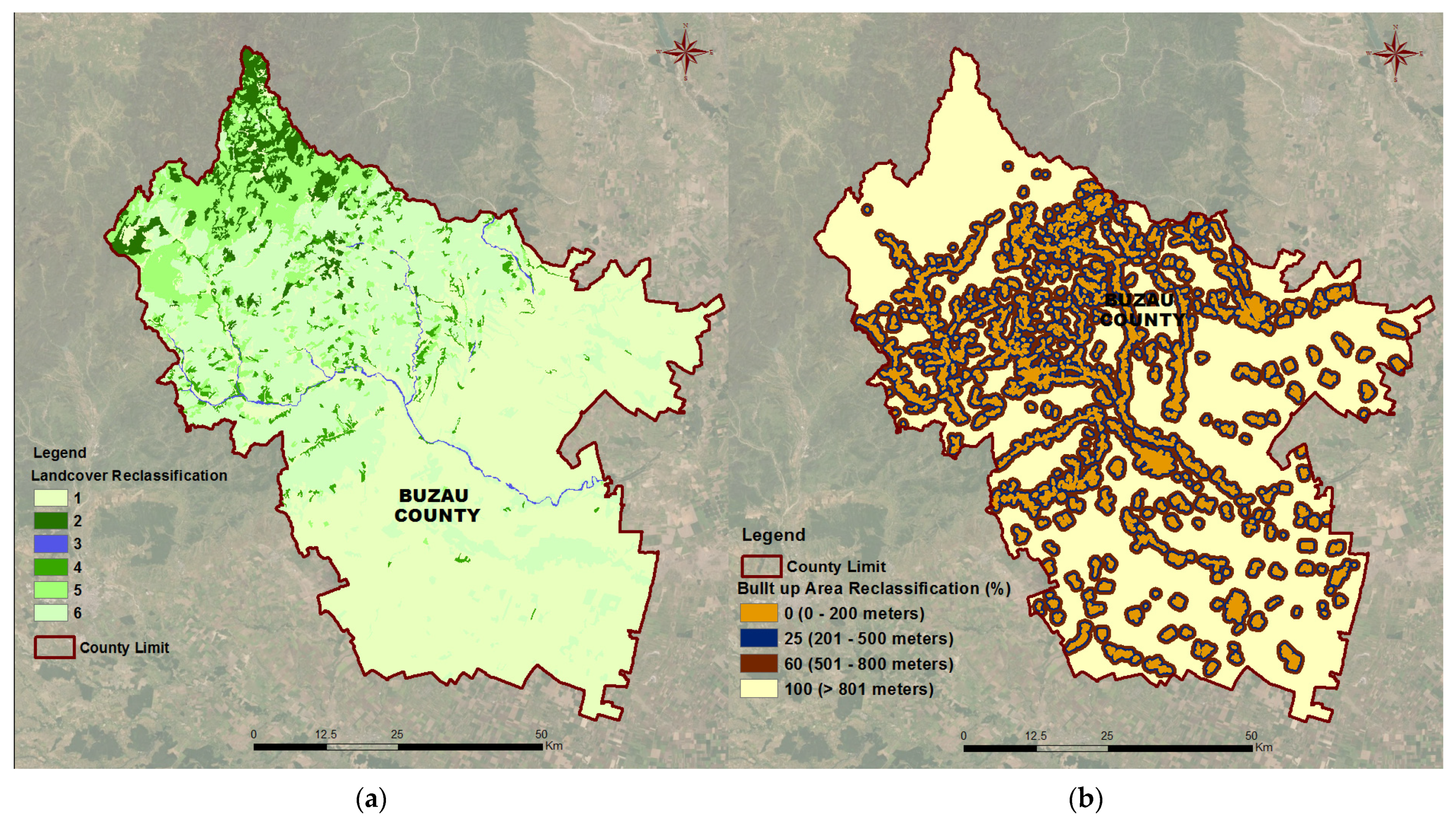
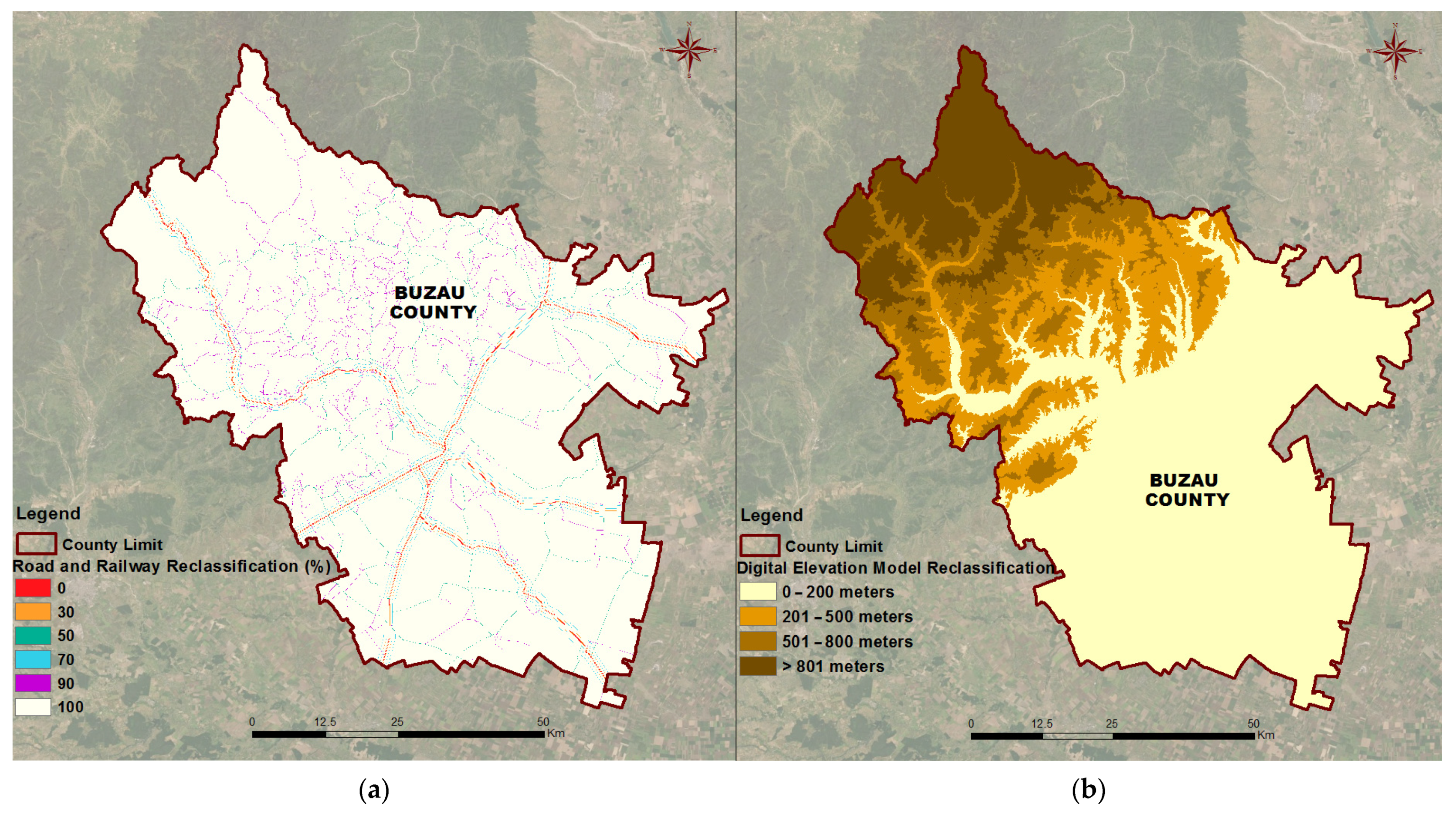
| Rasterization and standardization of input data series | Raster maps (30 × 30 m) | Habitat factors: CORINE (2018) for Romania National road and railroad network Traffic on national, county and communal roads in the County (2018) Built-up areas of all settlements from the County DTM based on contour lines (10 m) at County level Slopes derived from DTM Map of the occurrence of brown bear in Buzău County |
| Spatial Analyst–ArcGIS 10.6 | The layer of land cover in Buzău County (R1) | Weights identical to those of the 2018 CORINE raster | |
| The layer of built-up areas of the settlements in Buzău County (R2) | Weights depending on the distances between these areas | |||
| The layer of roads and railways in Buzău County (R3) | Weights depending on the distance between them and the existing traffic | |||
| The digital terrain model for Buzău County (R4) | Weights depending on altitude (from 0 to over 1000 m) | |||
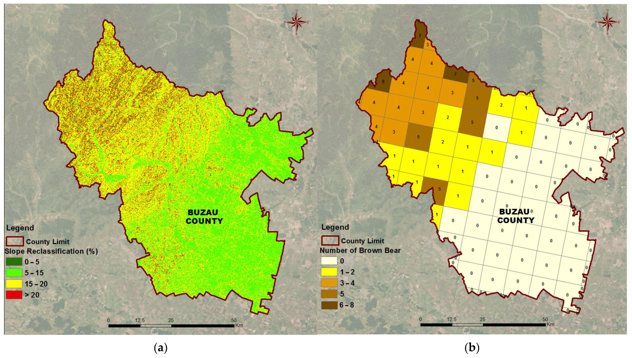
| The digital model of the land slope in Buzău County (R5) | Weights according to Corridor Design–Create topographic position raster application | |||
| Step 2: Assessment of brown bear habitat permeability at County level | Establishing the permeability of the landscape according to the behavioral characteristics of brown bear | Standardization by reclassification: ArcGIS 10.6 Corridor Design (Create habitat suitability model) | Permeability map of Buzău County (R6) | Weighting of all habitat factors used: 40 for land cover and 15 for all other raster |
| Step 3: Defining ecological corridors for brown bear in Buzău County | Establishing potential ecological corridors in the case of brown bear for Buzău County | Corridor Design (Create corridor model) | Map of potential ecological corridors for brown bear in Buzău County (R7) | Natura 2000 sites in the county were considered as core areas Ecological corridors were calculated for each 2 core areas |
Publisher’s Note: MDPI stays neutral with regard to jurisdictional claims in published maps and institutional affiliations. |
© 2022 by the authors. Licensee MDPI, Basel, Switzerland. This article is an open access article distributed under the terms and conditions of the Creative Commons Attribution (CC BY) license (https://creativecommons.org/licenses/by/4.0/).
Share and Cite
Popescu, O.-C.; Tache, A.-V.; Petrișor, A.-I. Methodology for Identifying Ecological Corridors: A Spatial Planning Perspective. Land 2022, 11, 1013. https://doi.org/10.3390/land11071013
Popescu O-C, Tache A-V, Petrișor A-I. Methodology for Identifying Ecological Corridors: A Spatial Planning Perspective. Land. 2022; 11(7):1013. https://doi.org/10.3390/land11071013
Chicago/Turabian StylePopescu, Oana-Cătălina, Antonio-Valentin Tache, and Alexandru-Ionuț Petrișor. 2022. "Methodology for Identifying Ecological Corridors: A Spatial Planning Perspective" Land 11, no. 7: 1013. https://doi.org/10.3390/land11071013