Article

Insect Outbreak and Long-Term Post-Fire Effects on Soil Erosion in Mediterranean Suburban Forest

by
Aristeidis Kastridis
1,*,
Dimitrios Stathis
1,
Marios Sapountzis
1 and
Georgios Theodosiou
2
1
Laboratory of Mountainous Water Management and Control, School of Forestry and Natural Environment, Aristotle University of Thessaloniki, 54124 Thessaloniki, Greece
2
School of Forestry and Natural Environment, Aristotle University of Thessaloniki, 54124 Thessaloniki, Greece
*
Author to whom correspondence should be addressed.
Land 2022, 11(6), 911; https://doi.org/10.3390/land11060911
Submission received: 30 May 2022 / Revised: 11 June 2022 / Accepted: 13 June 2022 / Published: 15 June 2022

Abstract

:
Our study was conducted in the suburban forest of Thessaloniki (Seich Sou), which constitutes one of the most significant suburban forests of Greece and is located northeast of Thessaloniki. In 1997, more than the half of the forest area was destroyed by a wildfire, while recently (May 2019), a significant insect outbreak by the bark beetle Tomicus piniperda was detected. The insect action still goes on, while the infestation has destroyed so far more than 300 ha of forest area. Extensive selective logging and removal of infected trees from the forest were carried out in order to mitigate and restrict the outbreak spread. In the current study, silt-fenced erosion plots were installed on representative locations of disturbed (by fire and insect action) and undisturbed areas, in order to quantify the effect of the above-mentioned forest disturbances on soil erosion and correlate the height and intensity of precipitation with the soil erosion rate. The results show that there was no statistically significant increase in soil erosion in the areas of insect outbreak compared with the control plots. However, there was a statistically significant increase in soil erosion in areas where logging works had been applied as an infestation preventive measure. In addition, the study revealed that 25 years after the forest fire, the erosion rate is still at higher level compared with the undisturbed forest areas. This study could be considered as one of the first attempts to evaluate the impact of an insect outbreak infestation on soil erosion, while there is also a great lack of information concerning the assessment of long-term post-fire effects on the soil erosion of a forest ecosystem.

1. Introduction

Soil erosion constitutes a serious environmental problem of a global impact and could be considered as a threat with long-term effects and different intensity levels among different areas [1]. Soil erosion involves two stages, the detachment of soil particles by the corrosive action of rain and the subsequent transfer of them through the surface runoff and wind forces [2]. The process of soil erosion could be characterized as the result of interaction between erosivity (forces that cause motion) and erodibility (soil resistance to movement) [3].
In the natural environment, the loss of soil is balanced by the parallel soil regeneration through rock weathering and pedogenesis. However, there are several cases in which the rate of erosion may be increased because of the destruction of the protective vegetation cover, attributed mainly to biotic and abiotic factors. Land use changes, forest wildfires, insect outbreaks, intensive tillage, and wrong soil conservation practices are some of the main disturbances, which result in increased rates of soil erosion [4,5,6,7]. Significant environmental consequences of soil erosion include water quality deterioration, soil degradation, floods, and land disasters [8], as well as increased sediment generation, transportation, and deposition in natural lakes and water reservoirs [9,10,11,12].
Forest wildfires are the most destructive phenomena that significantly affect the rate of soil erosion. The destruction of surface forest vegetation, the thermal effect on the soil, the decrease of soil organic matter, the ash cover, and the reduction of biological activity, can cause the increase of surface runoff and flood events [7,13,14,15,16,17]. The negative effects of fires on the forest ecosystems can be exacerbated, especially in the Mediterranean region where the appearance and impact of fires are even more intense, by the presence of fire-prone vegetation, the dry and hot summers, and the frequent events of intense rainfalls [17,18,19,20]. Additionally, the type and recovery rate of vegetation after a wildfire is one of the most important factors that highly influences the runoff and soil erosion rates [21,22] However, most of the recent studies have dealt with areas that were affected by forest fires, focusing mainly on the “disturbance window”, which is defined as the period of the highest soil losses (compared to the period before the forest fire) and usually ranges between 3 to 10 years [8,23,24,25,26,27,28]. The literature review reveals that there are only few studies investigating the long-term post-fire effects on soil erosion rates, especially those examining the period beyond 20–30 years after the forest wildfire [13,29].
In addition, other natural-related catastrophes, such as the insect outbreaks, have been on the rise in European forests over the recent decades [30,31]. The destruction of large forest ecosystems by biotic factors usually leads to significant economic losses and ecological disturbances and, in others, to increased soil erosion [32,33]. After an insect outbreak, the potential changes in surface runoff interception in the infected forests could generate increased flood events and soil erosion, even though these negative impacts are strongly influenced by the particular watershed characteristics and the applied management practices responding to the forest disturbances. Most studies underline the fact that insect outbreaks could potentially affect the soil erosion processes [33,34,35]. However, very little is known about the consequences of insect outbreaks on soil erosion rates. Currently, the literature does not provide thorough information and insightful knowledge on the quantification of soil erosion and its correlation to insect outbreaks phenomena. Quantitative and qualitative analysis of soil erosion is of particular importance to scientists and policymakers in order to assess the potential risk, to plan and apply mitigation measures, and to develop the appropriate reconstruction strategy for each case.
The current study was conducted in the suburban forest of Thessaloniki (Seich Sou), which is located at the northeast side of the city, constitutes one of the most important suburban forests of Greece [36,37], and is integral part of the identity of Thessaloniki [38]. In 1997, more than the half of the forest area was destroyed by a wildfire. Recently (May 2019), there was a significant insect outbreak caused by the bark beetle Tomicus piniperda, which was recognized after the necrosis of many pine trees (Pinus bruttia L.). Due to the infestation, more than 300 ha of forest were destroyed, while the infestation still continues. Extensive selective logging and removal of infected trees from the forest has been carried out recently in order to mitigate and restrict the outbreak spread.
In our study, in order to quantify the effect of the above-mentioned forest disturbances on soil erosion, silt-fenced erosion plots were installed on representative locations of disturbed and undisturbed forest areas. The main objectives of our study were (a) the quantification of soil erosion in representative areas: 1. areas naturally reforested after the wildfire of 1997, 2. areas with reforestation failure, 3. areas with insect outbreak, 4. areas with insect outbreak, followed by logging of dead trees, 5. undisturbed areas as a control; and (b) the investigation of the potential correlation of the precipitation to the soil erosion rate in these areas. The goal of the study was to draw conclusions about the long-term effects of wildfire (1997) on erosion rate and, for the first time in the literature, to estimate the effect of insect outbreak on soil erosion.

2. Materials and Methods

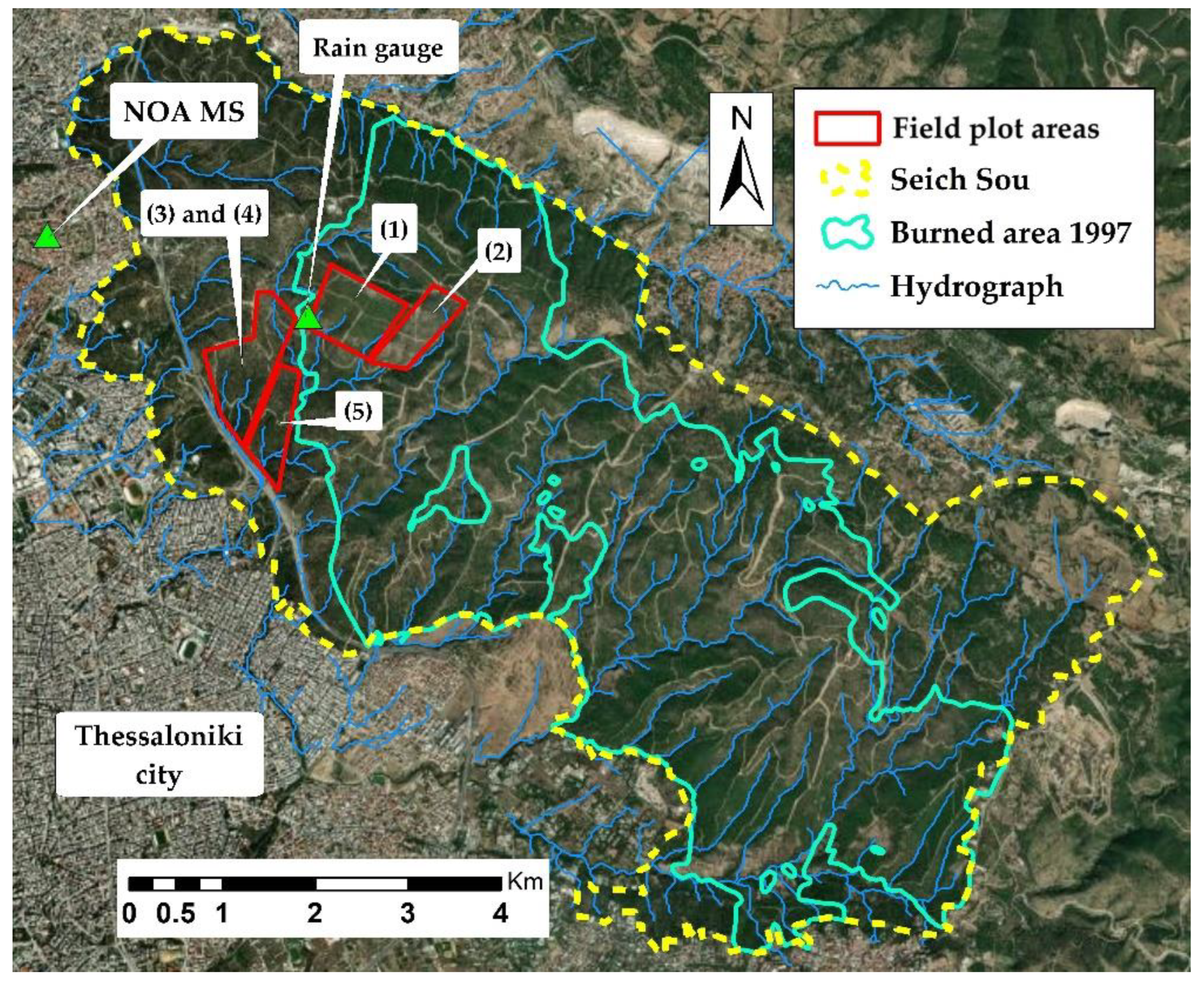
2.1. Study Area—1997 Wildfire–2019 Insect Outbreak

The suburban forest of Thessaloniki, known as “Seich Sou”, extends between 22°57′ to 23°04′ longitude and 40°35′ to 40°39′ latitude and covers an area of 3025.25 ha (Figure 1). The land use distribution is forest land (89.7%), crop land (6.6%), and pastures (1.3%), while the 2.4% corresponds to the ring road and some other special areas. The average age of “Seich Sou” is about 70 years, and the dominant tree species is Pinus brutia L. The relief of the forest could be characterized as hilly–semi-mountainous, relatively steep, with a mean altitude of 306.3 m a.s.l, 569.5 m max altitude, and 56.8 m min altitude, while the mean slope is 26.2% and the dominant aspect is SE-S-SW.
The dominant rock of the study area is gneiss, which is mainly impermeable to water and of considerable thickness. Most gneiss lithological types are easily weathered and covered by loose weathering mantle of ranging thickness, resulting in the manifestation of springs of usually low yield in its contact with the intact rock [39]. In May of 2001, the Forest Research Institute [40] of Thessaloniki published a detailed study analyzing the soil properties of “Seich Sou”, which was based on field research and lab analyses. In general, the soils of the area can be characterized as shallow, of medium mechanical composition, mainly sandy loam (SL), and with a distribution of horizons A, B, and C. The horizon A rarely exceeds 3 cm, while the horizon B is usually absent and is followed directly by the horizon C which is quite deep. The pH ranges between 6.66 and 7.35, while the soil depth from 0 to 30 cm.
Based on the available meteorological data [41], the climate of the region could be characterized as a typical Mediterranean climate, with very dry and warm summers and relatively mild winters (Figure 2). The mean annual rainfall is 444.5 mm, with a maximum in winter (December) and a secondary peak in spring (May). The mean annual temperature is 15.9 °C, the mean max is 20.4 °C, and the mean min is 10.1 °C.
The environmental and social benefits of this forest ecosystem are undoubtedly significant for the prosperity of Thessaloniki area, since it protects the city from floods and reduces soil erosion, while it contributes to soil formation, groundwater aquifers’ enrichment, and water quality improvement. In general, it improves environmental conditions, absorbs the carbon dioxide, reduces air pollutants, regulates the urban microclimate, provides oxygen, and improves further the residents’ life quality, providing opportunities for recreation activities and environmental education to the public [42,43,44].
However, many catastrophic events have occurred in the suburban forest over the last decades, either by human intervention or by other biotic/abiotic factors, such as diseases and insect outbreaks, which have caused the degradation of the forest ecosystem.
After the wildfire that took place in 1997, reforestation was implemented mainly by planting the species of Pinus brutia L., Cupressus sempervirens, Pinus halepensis L., and Pinus pinea L., as well as the broadleaf species Quercus pubescens and Quercus ilex, while a significant part of the burned areas was allowed to regenerated naturally [42,45]. In addition to the forest fire, a serious insect outbreak has been in progress in this forest since May of 2019. The infestation was identified mainly after the necrosis of many pine trees, the discoloration of their foliage, and other symptoms of the disease. The insect Tomicus piniperda is responsible for the destruction, which pre-existed in the forest for many years but in a much lower, controlled population. Its catastrophic action was recorded from mid-2019 along with the uncontrolled growth of its population, which can be attributed to the aging and gradual degradation of the forest by various factors. Due to the infestation, more than 300 ha of forest have been destroyed (10% of the forest) so far, while the infestation still continues. Extensive selective logging and removal of infected trees from the forest have been carried out to mitigate and restrict the infestation spread.

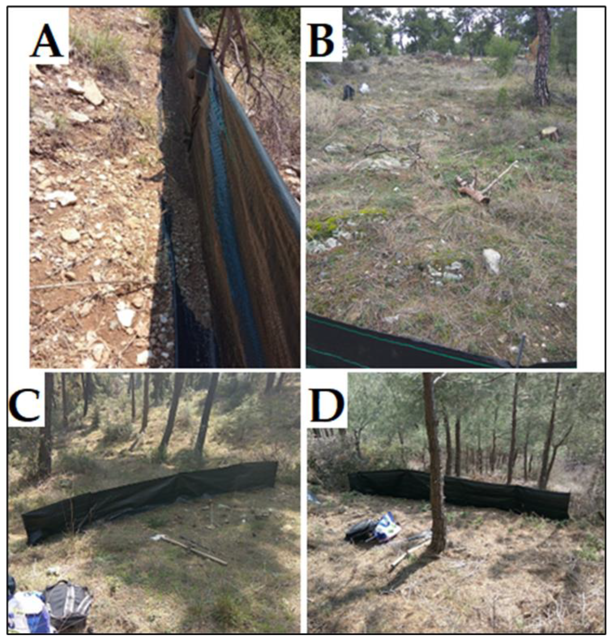
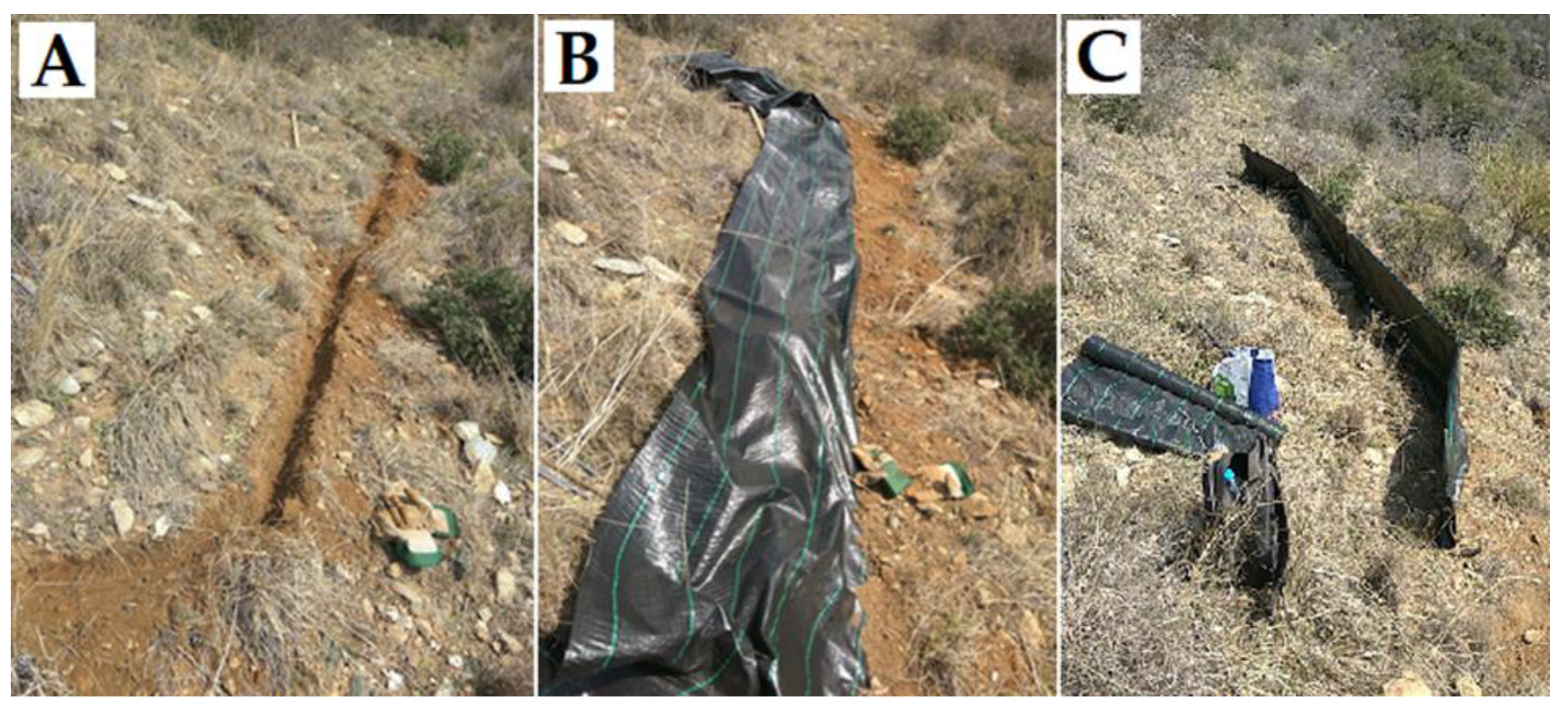
2.2. Field Plots (Silt Fences)—Data Collection

Soil erosion was measured by installing silt fences on field plots (disturbance cases) in representative forest areas (Figure 1): (1) areas naturally reforested after the wildfire of 1997, (2) areas characterized by reforestation failure, (3) areas infected by insects, (4) areas with insect outbreak and logging of dead trees, and (5) undisturbed areas as a control (Figure 3). The main characteristics of the field plots are the following:
(1): These plots are covered by young stands of Pinus brutia L. with a mean canopy density > 90%. Due to the dense forest canopy, the sunlight cannot reach the ground, which results in a very limited understory vegetation. The soil is covered with pine needles.
(2): In these plots, the forest regeneration after the 1997 fire has failed. They are covered mainly with grass vegetation (>75%) and have scattered areas of bare soil.
(3): These plots have suffered the insect outbreak. The canopy density is <40%, while the soil is covered mainly by grass and pine needles.
(4): In these plots, the dead trees were cut and removed by the forest service in an attempt to limit the spread of infestation. During the logging period, low intensity works were applied. Mainly, load animals were used to carry the dead trees from the logging areas to the forest road network. However, since the soil has been disturbed by these logging works and the dragging of logs, small skid trails have been created.
(5): These plots are typical and representative areas of “Seich Sou” Forest. The mean canopy density is >70%, while there is understory vegetation mainly constituted by grass/pine needles and sparse bushes of Quercus coccifera L.
The soil erosion in the burned areas was investigated and monitored by our laboratory directly after the forest fire of 1997 and for a 3-year period [23,43,45]. In this study, the aim of the field plots in the burned areas was to detect the potential long-term effects of forest fire on soil erosion.
For the measurement of soil erosion, silt fences have been successfully applied mainly in the United States in coniferous forests [46,47,48,49,50] and in Israel [51] in conditions similar to those prevailing in Greece. The main characteristics and advantages of the method are its ease of installation in different conditions, the low cost of supply and transportation of the required materials, and the measurement accuracy [52].
The site selection was based on the prevailing geomorphology conditions of the study area, taking into account the different conditions created by the forest fire in 1997, insect outbreak (May 2019), and the logging of dead trees that followed. The aspect (SE–S–SW), slope (25–36%), and soil properties of the field plots were chosen to be similar among the plots, in order to eliminate their influence on soil erosion measurements. GIS techniques were applied to combine these factors and to locate on the map the appropriate similar and representative areas [53,54]. Extensive field research was conducted toward the final selection of the exact locations for the silt fences installation. In total, 25 field plots were installed using silt fences, 5 for each case. Each plot measured 5 m along the contour and 22 m along the slope gradient, covering an area of 110 m2 (Figure 4). Small ditches about 15 cm wide and deep were dug at the top of each plot to prevent the surface flow entering the plot from above [52].
The field plots were monitored from December 2020 to January 2022, in which 17 field measurements were organized to collect the sediments from the silt fences. After each intense rainfall or once in a month (in case there was no intense rain), field work was carried out to collect the sediments retained by the silt fences. The weighing was implemented on site using a scale of 2 decimal places. A sample of soil material was collected from each silt fence every time and was later dried in the laboratory chamber at 105 °C for 24 h to calculate the soil water content and the dry weight of the eroded soil [52]. The sediments collected from each surface were summed and divided by the area of the field plot (110 m2) to obtain the annual erosion rate.

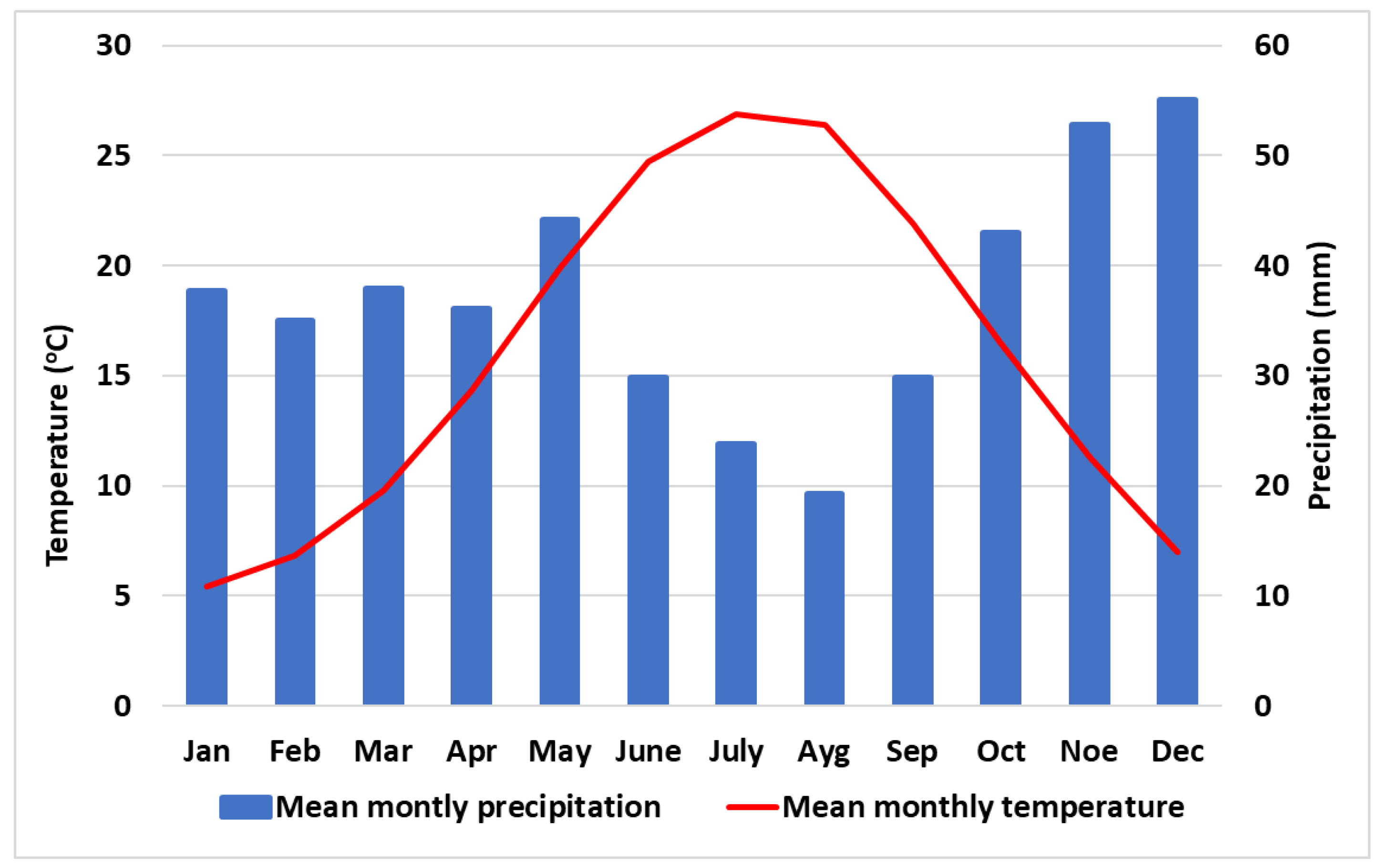
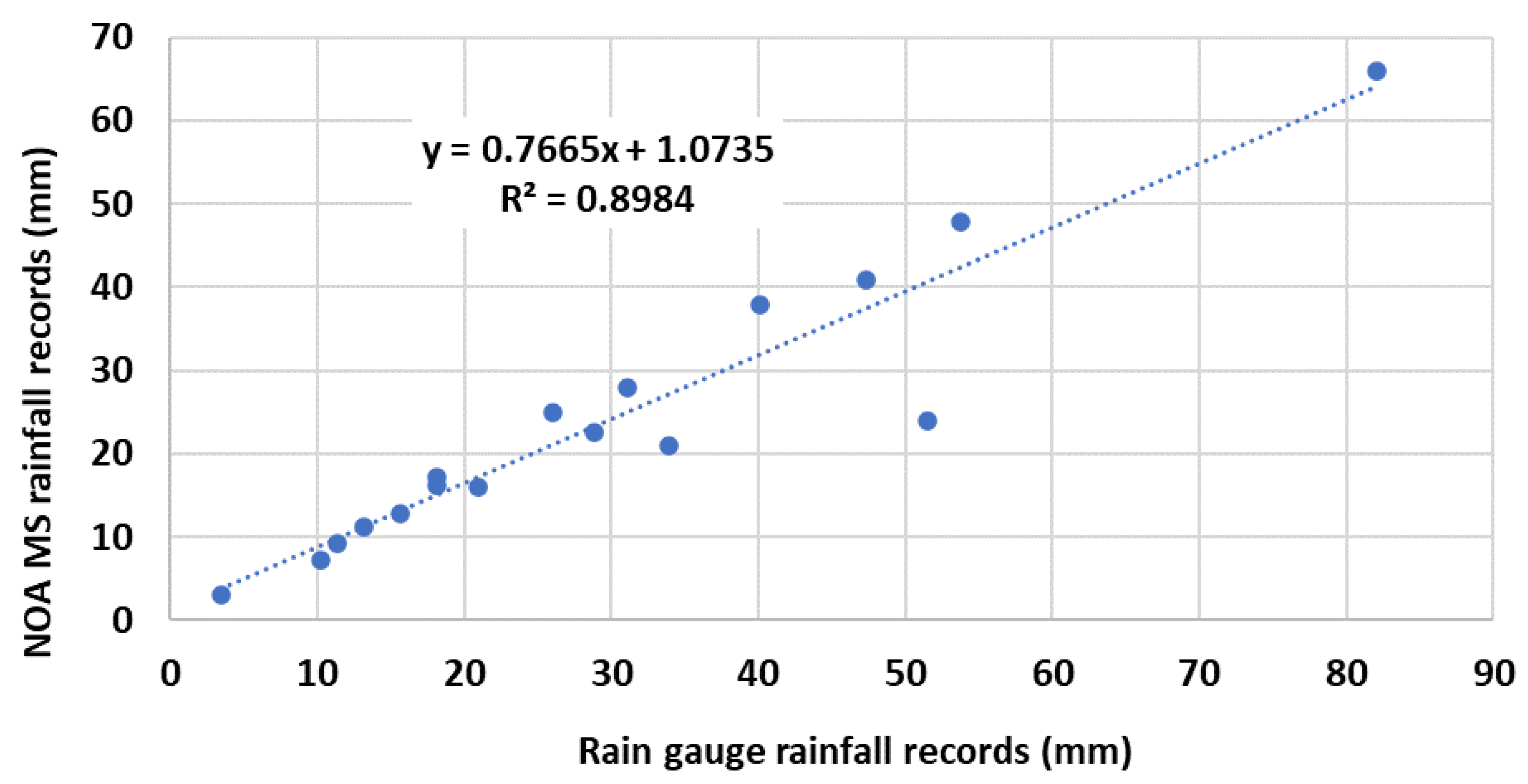
2.3. Precipitation—Statistical Analysis

The precipitation data were obtained by the National Observatory of Athens (NOA) automated meteorological station (MS) [55], which records at 10 min intervals. The NOA MS is located approximately 1.6 km away from the field plots (Figure 1). Due to the distance between the NOA MS and the study area and their altitude differences, a second cumulative rain gauge was installed in the study area to validate the NOA MS records. As it is evident in Figure 5, there was a slight underestimation of rainfall event values from the NOA MS, which could be attributed to the altitude difference, and it was taken into consideration during the statistical analysis.
To examine the effects of the different disturbance cases on soil erosion in relation to the precipitation, multiple linear regression analysis and analysis of variance (two-way ANOVA) were applied. The sediment amount values from field plots were considered as the dependent variable, while the 5 cases, 10 min rainfall intensity, total rainfall per event, and Antecedent Moisture Conditions (AMC) [56] were considered as independent variables. First, the “enter” method was applied to investigate all the possible combinations and relations between the variables. Next, the “stepwise” method was applied to exclude the non-statistically significant variables from the analysis. The statistically significant independent variables were subjected to two-way ANOVA in order to investigate the potential correlation between them. The statistical analysis of all the data was carried out at a significance level of 0.05.

3. Results and Discussion

3.1. Precipitation

During the field work in 2021, 95 rainfall events were recorded, mainly of low intensity and variable duration. The year 2021 was a typical year from the aspect of precipitation. The total annual precipitation was 445.4 mm, which corresponded to the mean annual precipitation of the last few decades (444.5 mm). It is noteworthy that the majority of the annual rainfall (405.8 mm) was generated from only 17 rainfall events. Of these 17 rainfall events, 7 generated little or no measurable erosion, while the remaining 10 events generated the whole sediment amount of the year (Table 1). More specifically, 68.8% of the annual precipitation was recorded during the 10 rainfall events.

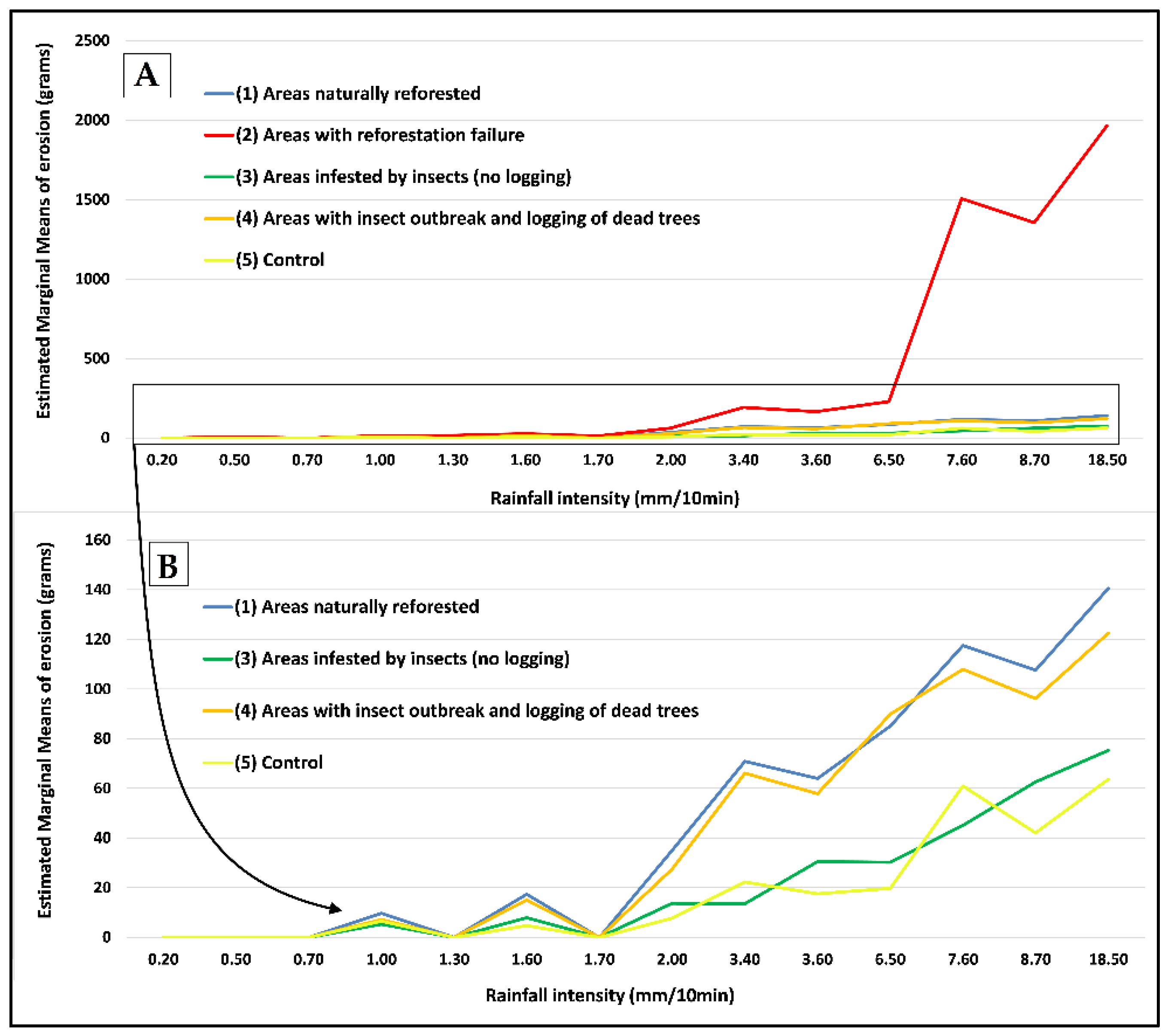
3.2. Field Plots Measurements—The Influence of Insect Outbreak and Long-Term Post-Fire Disturbances on Soil Erosion

The erosion production values for all the plots and cases recorded in 2021 are presented in Table 2. The total erosion production from all plots was 0.678 t/ha/year. As it was expected, the lowest values of soil erosion were recorded in (5) undisturbed areas (the control) (0.023 t/ha/year), while the highest were recorded in (2) areas of reforestation failure (0.51 t/ha/year), which was 22 times higher than that of the undisturbed areas (Table 2).
Comparing the four disturbed areas, the plots in (3) “insect outbreak (no logging)” presented the lowest soil erosion rate (0.027 t/ha/year). In addition, the difference between the plots of (3) “insect outbreak (no logging)” and (5) “control” was negligible, suggesting that the effect of entomological infestation on soil erosion was detectable and measurable, though very low. On the other hand, the plots with (4) “insect outbreak and logging of dead trees” showed twice the amount of erosion compared with the plots (3) with “insect outbreak (no logging)” and (5) “control” plots. As it is widely known, the heavy machinery or load animals used during the logging process leads to the opening of new harvest tracks and skid trails, which temporarily increase the soil erosion [57,58]. Additionally, harvest tracks and skid trails increase the connectivity with the hydrographic network, intensifying the transportation of sediment in the streams [59]. This fact showed that logging, as a measure to limit the infestation spread, could have positive results (not evaluated in the current study), but it also could trigger negative effects on soil erosion rates. Since this is the first time that a study addressed and quantified the effect of insect outbreak on soil erosion rates, it was not possible to compare our results with previous studies’ findings.
Concerning the long-term effects of the 1997 wildfire on soil erosion, the results from plots (1) with “natural reforestation” showed that 25 years after the wildfire, the erosion rates were triple (0.062 t/ha/year) compared with the (5) “control” plots (0.023 t/ha/year). Despite the fact that the erosion rate was very low, the results revealed that the forest ecosystem has not been fully restored. It seems that the widely known “window of disturbance” has not closed in the reforested area. Previous studies have reported that the “window of disturbance” begins immediately after the forest fire and spans a range of 3–10 years, depending on reforestation speed, site quality, and climate conditions [3,24,51,60,61]. However, most studies usually begin the measurements a few months after the forest fire and have a short period of monitoring [3], recording mainly the short-term effects. Our study was conducted 25 years after the wildfire, a fact which could explain why the “window of disturbance” in “Seich Sou” forest is longer than other areas. Respectively, in a recent study conducted in eastern Spain [29], the authors reported that 16 years after the forest fire, soil erosion was negligible, but it was still existent and measurable. In Mediterranean conditions, where the soils are often thin and stony [3], the restoration of the soil erosion rates to normal levels can take more than two decades, depending on site quality, geomorphology, and climate conditions.
In addition to the above analysis, it should be highlighted that in areas where the reforestation has failed (plots 2), the soil erosion rate was found to be eight times higher than the reforested areas (1) and 22 times higher than that of the control areas (5). The results confirm the extremely significant positive effect of natural forest regeneration, but they also reveal the necessity of artificial reforestation especially in cases where the natural reforestation fails.

3.3. Statistical Analysis—Relationship among Soil Erosion, Precipitation, and Forest Disturbances

The multiple linear regression analysis showed that the AMC and total rainfall per event were not statistically significant variables and were excluded from further analysis. These results confirm previous studies’ findings, which reported that long duration rainfall events independently of the AMC could not produce significant amounts of sediments, because of the low impact force of raindrops and the higher infiltration rates of excess runoff [62,63,64]. Figure 6A depicts the differences between the cases for each rainfall intensity (mm/10 min). It is clear that the plots (2) present a higher erosion rate than the other plots did, which have relatively similar erosion values. However, focusing on the plots (1), (3), (4), and (5) of Figure 6B clearly reveals that there were differences among these plots.
More specifically, between (5) “control” and (3) “infestation (no logging)” plots, there is no statistically significant difference between the soil erosion values (p value = 0.854). These two cases presented similar values of erosion with small differences, despite the fact that plots with (3) “infestation (no logging)” had higher erosion values (Table 2). In fact, this shows that the insect outbreak did not influence the soil erosion in a significant way. A potential explanation could be that the standing dead trees with the remaining dry canopy could to some extent decrease the rain impact on the soil (reduction of speed, drifting force, etc.). In addition, when the dead trees fall on the ground, they act as contour log barriers, retaining significant amounts of sediments and reducing the water runoff speed and the connectivity with the hydrographic network.
On the other hand, the plots (1) and (4) presented a statistically significant different in comparison to (5) “control” and (3) “infestation (no logging)” plots. Logging works immediately exposed the soil to the rain’s impact, leaving it unprotected against the corrosive action of rain. Additionally, as mentioned above, the logging works disturbed the soil, resulting in increased erosion rate. In Table 3, the pairwise comparisons from two-way ANOVA are provided in detail.
Concerning the effect of rainfall intensity on soil erosion among all cases, the statistical analysis showed that there is a threshold above which the soil erosion production is more intense (Table 4). This threshold value is above 6.5 mm/10 min. Specifically, 4.2% of the variability of soil erosion of the examined cases was attributed to 6.5 mm/10 min rainfall intensity. Soil erosion variability increases significantly, as the rainfall intensity increases.
Specifically, for 7.6, 8.7, and 18.5 mm/10 min rainfall intensities, the variability of soil erosion among all cases is 72.1%, 67.5%, and 81.6%, respectively. There are previous studies concerning the beginning of intense soil erosion that discuss this threshold value. However, there are differences among the studies that could be attributed to the different geomorphological, climate, land cover, and experimental conditions under which the measurements were conducted [62,65,66,67]. Generally, the driving factor that mostly influences soil erosion is the rainfall intensity, but the examined cases also present a statistically significant effect, mainly during the most intense rainfall episodes (>6.5 mm/10 min.).
It should be highlighted that the mean annual erosion rate, which has been measured in our study, could be considered as negligible compared with the previous studies conducted in the Mediterranean region [7]. The annual erosion rate in the study area was 0.678 t/ha/year, which could be considered very low, taking into account the lower and upper limits of soil erosion in Europe (0.1–19.8 t/ha/year) [7,68,69,70]. Additionally, the soil erosion rate of the study area is also low when considering that the widely accepted limits of soil formation in Europe are between 0.3 and 1.4 t/ha/year [68,71,72]. However, it should be highlighted that low erosion rates are typical in some Mediterranean regions where the soils are often thin, stony, and already degraded [3,6,73].

4. Conclusions

Our study was conducted in the suburban forest of Thessaloniki (Seich Sou), in which a serious insect outbreak has been in progress since May of 2019 and has already destroyed more than 300 ha of forest area (10% of the forest). Extensive selective logging and removal of infected trees from the forest was carried out to restrict the outbreak spread. In addition, in 1997, more than the half of the forest area was destroyed by a wildfire. The current research quantified the soil erosion using silt fences in representative areas (25 field plots): (1) areas naturally reforested after the 1997 wildfire, (2) areas characterized by reforestation failure, (3) areas infected by insects, (4) areas with insect outbreak and logging of dead trees, and (5) undisturbed areas as a control, and we correlated the precipitation to the soil erosion rate.
The results show that the erosion rate in the study area was generally low compared with other Mediterranean regions. However, it was revealed for the first time that the insect outbreaks could cause a soil erosion increase, depending on the climate, soil properties, and geomorphological characteristics. Furthermore, it was proven that 25 years after the forest wildfire, the reforested areas have not been fully restored, and the widely known “window of disturbance” has not closed in the reforested areas. Additionally, the areas of reforestation failure exhibited the highest values of soil erosion, indicating the need for technical reforestation in such cases. Finally, the results reveal that the suburban forest of Thessaloniki (Seich Sou) is not under significant threat from soil erosion since the erosion rates are very low and lower than the soil formation rates. However, the results of the soil erosion of the disturbed areas show that an already degraded forest ecosystem is very sensitive against various abiotic/biotic threats. Efforts to upgrade the health and quality of the suburban forest are imperative, while special soil-erosion preventive measures should be planned by the respective authorities in order to successfully face asymmetric threats, which are expected to increase in the future due to climate change.

Author Contributions

Conceptualization, A.K. and D.S.; methodology, A.K. and D.S.; software, A.K.; validation, A.K. and G.T.; formal analysis, A.K. and M.S.; investigation, A.K. and G.T.; data curation, A.K. and M.S.; writing—original draft preparation, A.K.; writing—review and editing, A.K., M.S., and G.T.; visualization, A.K.; supervision, D.S. All authors have read and agreed to the published version of the manuscript.

Funding

This research received no external funding.

Institutional Review Board Statement

Not applicable.

Informed Consent Statement

Not applicable.

Data Availability Statement

The data that support the findings of this study are available from the corresponding author upon reasonable request.

Conflicts of Interest

The authors declare no conflict of interest.

References

  1. Pastor, A.V.; Nunes, J.P.; Ciampalini, R.; Koopmans, M.; Baartman, J.; Huard, F.; Calheiros, T.; Le-Bissonnais, Y.; Keizer, J.J.; Raclot, D. Projecting Future Impacts of Global Change Including Fires on Soil Erosion to Anticipate Better Land Management in the Forests of NW Portugal. Water 2019, 11, 2617. [Google Scholar] [CrossRef] [Green Version]
  2. Morgan, R.P.C. Soil Erosion and Conservation, 2nd ed.; Longman: Harlow, UK, 1995. [Google Scholar]
  3. Shakesby, R.A. Post-wildfire soil erosion in the Mediterranean: Review and future research directions. Earth-Sci. Rev. 2011, 105, 71–100. [Google Scholar] [CrossRef]
  4. Borrelli, P.; Robinson, D.A.; Fleischer, L.R.; Lugato, E.; Ballabio, C.; Alewell, C.; Meusbuger, K.; Modugno, S.; Schutt, B.; Ferro, V.; et al. An assessment of the global impact of 21st century land use change on soil erosion. Nat. Commun. 2017, 8, 1–13. [Google Scholar] [CrossRef] [Green Version]
  5. Panagos, P.; Borrelli, P.; Poesen, J. Soil loss due to crop harvesting in the European Union: A first estimation of an underrated geomorphic process. Sci. Total Environ. 2019, 664, 487–498. [Google Scholar] [CrossRef]
  6. Shakesby, R.A.; Bento, C.P.; Ferreira, C.S.; Ferreira, A.J.; Stoof, C.R.; Urbanek, E.; Walsh, R.P. Impacts of prescribed fire on soil loss and soil quality: An assessment based on an experimentally-burned catchment in Central Portugal. Catena 2015, 128, 278–293. [Google Scholar] [CrossRef]
  7. Ferreira, C.S.S.; Seifollahi-Aghmiuni, S.; Destouni, G.; Ghajarnia, N.; Kalantari, Z. Soil degradation in the European Mediterranean region: Processes, status and consequences. Sci. Total Environ. 2022, 805, 150106. [Google Scholar] [CrossRef]
  8. Depountis, N.; Michalopoulou, M.; Kavoura, K.; Nikolakopoulos, K.; Sabatakakis, N. Estimating Soil Erosion Rate Changes in Areas Affected by Wildfires. ISPRS Int. J. Geo-Inf. 2020, 9, 562. [Google Scholar] [CrossRef]
  9. Kastridis, A.; Stathis, D. The effect of small earth dams and reservoirs on water management in North Greece (Kerkini municipality). Silva Balc. 2015, 16, 71–84. [Google Scholar]
  10. Iradukunda, P.; Bwambale, E. Reservoir sedimentation and its effect on storage capacity–A case study of Murera reservoir, Kenya. Cogent Eng. 2021, 8, 1917329. [Google Scholar] [CrossRef]
  11. Kastridis, A.; Kamperidou, V. Influence of land use changes on alluviation of Volvi Lake wetland (North Greece). Soil Water Res. 2015, 10, 121–129. [Google Scholar] [CrossRef] [Green Version]
  12. Kalinderis, M.; Sapountzis, D.; Stathis, F.; Tziaftani, P.; Kourakli, P.; Stefanidis, P. The Risk of Sedimentation of Artificial Lakes, Following the Soil Loss and Degradation Process in the Wider Drainage Basin. Artificial Lake of Smokovo Case Study (Central Greece). International Conference LAND CONSERVATION 0905, Tara Mountain, Serbia, May 26–30, 2009. Global Change. Challenges for Soil Management. Advances in GeoEcology 41; Miodrag, Z., Ed.; Catena Verlag: Stuttgart, Germany, 2009; pp. 129–140. ISBN 978-3-923381-57-9. [Google Scholar]
  13. Wittenberg, L.; Inbar, M. The Role of Fire Disturbance on Runoff and Erosion Processes–a Long-Term Approach, Mt. Carmel Case Study, Israel. Geographical Res. 2009, 47, 46–56. [Google Scholar] [CrossRef]
  14. Cerdà, A.; Robichaud, P.R. (Eds.) Fire Effects on Soils and Restoration Strategies; Science Publishers: Enfield, UK, 2009; p. 569. [Google Scholar]
  15. Hedo, J.; Lucas-Borja, M.E.; Wic, C.; Andrés-Abellán, M.; De Las Heras, J. Soil microbiological properties and enzymatic activities of long-term post-fire recovery in dry and semiarid Aleppo pine (Pinus halepensis M.) forest stands. Solid Earth 2015, 6, 243–252. [Google Scholar] [CrossRef] [Green Version]
  16. Pereira, P.; Cerdà, A.; Úbeda, X.; Mataix-Solera, J.; Arcenegui, V.; Zavala, L.M. Modelling the Impacts of Wildfire on Ash Thickness in a Short-Term Period. Land Degrad. Dev. 2015, 26, 180–192. [Google Scholar] [CrossRef]
  17. Kastridis, A.; Kamperidou, V. Evaluation of the post-fire erosion and flood control works in the area of Cassandra (Chalkidiki, North Greece). J. For. Res. 2015, 26, 209–217. [Google Scholar] [CrossRef] [Green Version]
  18. Zavala, L.M.M.; de Celis Silvia, R.; López, A.J. How wildfires affect soil properties. A brief review. Cuad. Investig. Geogr. Geogr. Res. Lett. 2014, 40, 311–331. [Google Scholar] [CrossRef] [Green Version]
  19. Lucas-Borja, M.E.; Zema, D.A.; Carrà, B.G.; Cerdà, A.; Plaza-Alvarez, P.A.; Cózar, J.S.; Gonzalez-Romero, J.; Moya, D.; de las Heras, J. Short-term changes in infiltration between straw mulched and non-mulched soils after wildfire in Mediterranean forest ecosystems. Ecol. Eng. 2018, 122, 27–31. [Google Scholar] [CrossRef] [Green Version]
  20. Zema, D.A.; Lucas-Borja, M.E.; Fotia, L.; Rosaci, D.; Sarnè, G.M.; Zimbone, S.M. Predicting the hydrological response of a forest after wildfire and soil treatments using an Artificial Neural Network. Comput. Electron. Agric. 2020, 170, 105280. [Google Scholar] [CrossRef]
  21. Cerdà, A.; Lucas-Borja, M.E.; Franch-Pardo, I.; Úbeda, X.; Novara, A.; López-Vicente, M.; Pulido, M. The role of plant species on runoff and soil erosion in a Mediterranean shrubland. Sci. Total Environ. 2021, 799, 149218. [Google Scholar] [CrossRef]
  22. Cerdà, A.; Lucas Borja, M.E.; Úbeda, X.; Martínez-Murillo, J.F.; Keesstra, S. Pinus halepensis M. versus quercus ilex subsp. rotundifolia L. runoff and soil erosion at pedon scale under natural rainfall in eastern Spain three decades after a forest fire. For. Ecol. Manag. 2017, 400, 447–456. [Google Scholar] [CrossRef] [Green Version]
  23. Stefanidis, P.; Sapountzis, M.; Stathis, D. Sheet erosion after fire at the urban forest of Thessaloniki (northern Greece). Silva Balc. 2002, 2, 65–77. [Google Scholar]
  24. Inbar, M.; Wittenberg, L.; Tamir, M. Soil erosion and forestry management after wildfire in a Mediterranean woodland, Mt. Carmel, Israel. Int. J. Wildland Fire 1997, 7, 285–294. [Google Scholar] [CrossRef]
  25. Bodí, M.B.; Doerr, S.H.; Cerdà, A.; Mataix-Solera, J. Hydrological effects of a layer of vegetation ash on underlying wettable and water repellent soil. Geoderma 2012, 191, 14–23. [Google Scholar] [CrossRef]
  26. Pereira, P.; Cerdà, A.; Úbeda, X.; Mataix-Solera, J.; Martin, D.; Jordán, A.; Burguet, M. Spatial models for monitoring the spatio-temporal evolution of ashes after fire and ash; A case study of a burnt grassland in Lithuania. Solid Earth 2013, 4, 153–165. [Google Scholar] [CrossRef] [Green Version]
  27. Efthimiou, N.; Psomiadis, E.; Panagos, P. Fire severity and soil erosion susceptibility mapping using multi-temporal Earth Observation data: The case of Mati fatal wildfire in Eastern Attica Greece. Catena 2020, 187, 104320. [Google Scholar] [CrossRef] [PubMed]
  28. Lucas-Borja, M.E.; Parhizkar, M.; Zema, D.A. Short-Term Changes in Erosion Dynamics and Quality of Soils Affected by a Wildfire and Mulched with Straw in a Mediterranean Forest. Soil Syst. 2021, 5, 40. [Google Scholar] [CrossRef]
  29. Cerdà, A.; Keesstra, S.; Pereira, P.; Matrix-Solera, J.; Giménez-Morera, A.; Úbeda, X.; Francos, M.; Alcañiz, M.; Jordán, A. Long-term changes in soil erosion due to forest fires. A rainfall simulation approach in Eastern Spain. Geophys. Res. Abstr. 2016, 18, EGU2016-17261. [Google Scholar]
  30. BIO Intelligence Service. Disturbances of EU Forests Caused by Biotic Agents, Final Report Prepared for European Commission; BIO Intelligence Service: Paris, France, 2011. [Google Scholar]
  31. Hlásny, T.; Krokene, P.; Liebhold, A.; Montagné-Huck, C.; Müller, J.; Qin, H.; Raffa, K.; Schelhaas, M.-J.; Seidl, R.; Svoboda, M.; et al. Living with Bark Beetles: Impacts, Outlook and Management Options. From Science to Policy 8; European Forest Institute: Joensuu, Finland, 2019. [Google Scholar]
  32. Seidl, R.; Fernandes, P.M.; Fonseca, T.F.; Gillet, F.; Jonsson, A.M.; Merganicova, K.; Netherer, S.; Arpaci, A.; Bontemps, J.D.; Bugmann, H.; et al. Modelling natural disturbances in forest ecosystems: A review. For. Ecol. Manag. 2011, 222, 903–924. [Google Scholar] [CrossRef] [Green Version]
  33. Nikolov, C.; Konôpka, B.; Kajba, M.; Galko, J.; Kunca, A.; Janský, L. Post-disaster Forest Management and Bark Beetle Outbreak in Tatra National Park, Slovakia. Mt. Res. Dev. 2014, 34, 326–335. [Google Scholar] [CrossRef]
  34. Agne, M.C.; Beedlow, P.A.; Shaw, D.C.; Woodruff, D.R.; Lee, E.H.; Cline, S.P.; Comeleo, R.L. Interactions of Predominant Insects and Diseases with Climate Change in Douglas-Fir Forests of Western Oregon and Washington, USA. For. Ecol. Manag. 2018, 409, 317–332. [Google Scholar] [CrossRef]
  35. McCollum, D.W.; Lundquist, J.E. Bark beetle infestation of western US forests: A context for assessing and evaluating impacts. J. For. 2019, 117, 171–177. [Google Scholar] [CrossRef]
  36. Chatzichristaki, C.; Zagas, T. The contribution of natural and artificial regeneration at the restoration of fire-affected periurban forest of Thessaloniki (Northern Greece). Glob. NEST J. 2017, 19, 29–36. [Google Scholar] [CrossRef]
  37. Barmpoutis, P.; Kamperidou, V.; Stathaki, T. Estimation of extent of trees and biomass infestation of the suburban forest of Thessaloniki (Seich Sou) using UAV imagery and combining R-CNNs and multichannel texture analysis. In Proceedings of the SPIE 11433, Twelfth International Conference on Machine Vision (ICMV 2019), Amsterdam, The Netherlands, 31 January 2020; p. 114333C. [Google Scholar] [CrossRef]
  38. Spiridonidis, D. Specific Issues and Concerns on the Subject of the Competition, from Proceedings of the Urban Outdoor Landscape Architecture Symposium, Thessaloniki Announcement, European Student Competition Robert Schmidt Award 1993; 1–3 April 1994; Ananiadou-Tzimopoylou M.: Thessaloniki, Greece, 1994; pp. 127–131. [Google Scholar]
  39. Institute of Geology and Mineral Exploitation (IGME). Engineering Geological Map of Greece, Scale 1:500000; Institute of Geology and Mineral Exploitation (IGME): Athens, Greece, 1993. [Google Scholar]
  40. Forest Research Institute of Thessaloniki. Installation of a System for Monitoring the Developments in the Suburban Forest of Thessaloniki (Seich Sou) and Preparation of a Study for the Selection of Forest Species in Fire-Affected Areas; Forest Research Institute of Thessaloniki: Thessaloniki, Greece, 2001. [Google Scholar]
  41. Hellenic National Meteorological Service. Climatic Data for Selected Stations in Greece, 2020, Central Macedonia; Hellenic National Meteorological Service: Thessaloniki, Greece, 2020.
  42. Zagas, T. The Contribution of Natural Ecosystem Research to the Implementation of Afforestation Programs. In Proceedings of the Conference on “Selection of Planting Material for Forestry, Reforestation and Urban and Natural Landscape Improvement”, TEI of Kavala, Department of Forestry, Drama, Greece, 6 June 2003; pp. 39–51. [Google Scholar]
  43. Stefanidis, P.; Stathis, D.; Mitoglou, A. Anti-corrosion and anti-flood works in the burned areas of the Thessaloniki suburban forest. In Proceedings of the International Scientific Conference “Fires in Mediterranean Forests: Prevention-Suppression-Soil Erosion-Reforestation”, Athens, Greece, 3–6 February 1999. [Google Scholar]
  44. Samara, T.; Tsitsoni, T. Quality control and tree care measures in urban areas. In Proceedings of the 11th Panhellenic Conference. “Politics-Prey Forests-Protection of the Natural Environment” Hellenic Forestry Society, Olympia, Greece, 1–3 October 2003. [Google Scholar]
  45. Sapountzis, M.A.; Efthimiou, G.S.; Stefanidis, P.S. The contribution of agrotechnical works after a fire in the protection of forests soils and the installation of the natural reforestation. In International Conference “The Use of Vegetation to Improve Slope Stability” (Eco-Engineering Conference), European Society for Soil Conservation, IUFRO και World Association of Soil and Water Conservation, Thessaloniki, Greece, 13–17 September 2004; Proceedings of the First International Conference on Eco-Engineering; Stokes, A., Spanos, I., Norris, J., Cammeraat, E., Eds.; Springer: Berlin/Heidelberg, Germany, 2004; pp. 353–360. [Google Scholar]
  46. De Dios Benavides-Solorio, J.; MacDonald, L.H. Measurement and prediction of post-fire erosion at the hillslope scale, Colorado Front Range. Int. J. Wildland Fire 2005, 14, 457–474. [Google Scholar] [CrossRef] [Green Version]
  47. Wohlgemuth, P.M.; Hubbert, K.R.; Robichaud, P.R. The effects of log erosion barriers on post-fire hydrologic response and sediment yield in small forested watersheds, southern California. Hydrol. Process. 2001, 15, 3053–3066. [Google Scholar] [CrossRef]
  48. Robichaud, P.R. Measurement of post-fire hillslope erosion to evaluate and model rehabilitation treatment effectiveness and recovery. Int. J. Wildland Fire 2005, 14, 475–485. [Google Scholar] [CrossRef] [Green Version]
  49. Wagenbrenner, J.W.; MacDonald, L.H.; Rough, D. Effectiveness of three post-fire rehabilitation treatments in the Colorado Front Range. Hydrol. Process. 2006, 20, 2989–3006. [Google Scholar] [CrossRef] [Green Version]
  50. Robichaud, P.R.; Pierson, F.B.; Brown, R.E.; Wagenbrenner, J.W. Measuring effectiveness of three postfire hillslope erosion barrier treatments, western Montana, USA. Hydrol. Process. 2008, 22, 159–170. [Google Scholar] [CrossRef]
  51. Inbar, M.; Tamir, M.; Wittenberg, L. Runoff and erosion processes after a forest fire in Mount Carmel, a Mediterranean area. Geomorphology 1998, 24, 17–33. [Google Scholar] [CrossRef]
  52. Robichaud, P.R.; Brown, R.E. Silt Fences: An Economical Technique for Measuring Hillslope Soil Erosion; General Technical Report RMRSGTR-94; U.S. Department of Agriculture, Forest Service, Rocky Mountain Research Station: Fort Collins, CO, USA, 2002.
  53. Tzioutzios, C.; Kastridis, A. Multi-Criteria Evaluation (MCE) Method for the Management of Woodland Plantations in Floodplain Areas. ISPRS Int. J. Geo-Inf. 2020, 9, 725. [Google Scholar] [CrossRef]
  54. Cheng, C.H.; Thompson, R.G. Application of boolean logic and GIS for determining suitable locations for Temporary Disaster Waste Management Sites. Int. J. Disaster Risk Reduct. 2016, 20, 78–92. [Google Scholar] [CrossRef]
  55. Lagouvardos, K.; Kotroni, V.; Bezes, A.; Koletsis, I.; Kopania, T.; Lykoudis, S.; Vougioukas, S. The automatic weather stations NOANN network of the National Observatory of Athens: Operation and database. Geosci. Data J. 2017, 4, 4–16. [Google Scholar] [CrossRef]
  56. Chow, V.T.; Maidment, D.R.; Mays, L.W. Applied Hydrology; McGraw-Hill: New York, NY, USA, 1988; p. 572. [Google Scholar]
  57. Kastridis, A. Impact of Forest Roads on Hydrological Processes. Forests 2020, 11, 1201. [Google Scholar] [CrossRef]
  58. Sidle, R.C.; Sasaki, S.; Otsuki, M.; Noguchi, S.; Rahim, N.A. Sediment pathways in a tropical forest: Effects of logging roads and skid trails. Hydrol. Process. 2004, 18, 703–720. [Google Scholar] [CrossRef]
  59. Keesstra, S.; Nunes, J.P.; Saco, P.; Parsons, T.; Poeppl, R.; Masselink, R.; Cerdà, A. The way forward: Can connectivity be useful to design better measuring and modelling schemes for water and sediment dynamics? Sci. Total Environ. 2018, 644, 1557–1572. [Google Scholar] [CrossRef] [PubMed]
  60. Robichaud, P.R.; Beyers, J.L.; Neary, D.G. Evaluating the Effectiveness of Postfire Rehabilitation Treatments; General Technical Report RMRS-GTR-63; U.S. Department of Agriculture, Forest Service, Rocky Mountain Research Station: Washington, DC, USA, 2000.
  61. Mayor, A.G.; Bautista, S.; Llovet, J.; Bellot, J. Post-fire hydrological and erosional responses of a Mediterranean landscape: Seven years of catchment-scale dynamics. Catena 2007, 71, 68–75. [Google Scholar] [CrossRef]
  62. Piacentini, T.; Galli, A.; Marsala, V.; Miccadei, E. Analysis of Soil Erosion Induced by Heavy Rainfall: A Case Study from the NE Abruzzo Hills Area in Central Italy. Water 2018, 10, 1314. [Google Scholar] [CrossRef] [Green Version]
  63. Mohamadi, M.A.; Kavian, A. Effects of rainfall patterns on runoff and soil erosion in field plots. Int. Soil Water Conserv. Res. 2015, 3, 273–281. [Google Scholar] [CrossRef] [Green Version]
  64. Van Dijk, A.I.J.M.; Bruijnzeel, L.A.; Rosewell, C.J. Rainfall intensity-kinetic energy relationships: A critical literature appraisal. J. Hydrol. 2002, 261, 1–23. [Google Scholar] [CrossRef]
  65. Liu, C.; Wang, K.; Gao, L.; Sun, Y.; Yang, Q.; Cao, B.; Chen, L.; Xue, D.; Wang, J. Influence of Rainfall Intensity and Slope on Runoff and Sediment Reduction Benefits of Fine Mesh Net on Construction Spoil Deposits. Sustainability 2022, 14, 5288. [Google Scholar] [CrossRef]
  66. Dunkerley, D.L. Rainfall intensity bursts and the erosion of soils: An analysis highlighting the need for high temporal resolution rainfall data for research under current and future climates. Earth Surf. Dyn. 2019, 7, 345–360. [Google Scholar] [CrossRef] [Green Version]
  67. Almeida, W.S.D.; Seitz, S.; Oliveira, L.F.C.D.; Carvalho, D.F.D. Duration and intensity of rainfall events with the same erosivity change sediment yield and runoff rates. Int. Soil Water Conserv. Res. 2021, 9, 69–75. [Google Scholar] [CrossRef]
  68. Verheijen, F.G.A.; Jones, R.J.A.; Rickson, R.J.; Smith, C.J. Tolerable versus actual soil erosion rates in europe. Earth-Sci. Rev. 2009, 94, 23–38. [Google Scholar] [CrossRef] [Green Version]
  69. Cerdan, O.; Poesen, J.; Govers, G.; Saby, N.; Le Bissonnais, Y.; Gobin, A.; Vacca, A.; Quinton, J.; Auerswald, K.; Klik, A.; et al. Sheet and Rill Erosion. In Soil Erosion in Europe; Boardman, J., Poesen, J., Eds.; John Wiley & Sons: Hoboken, NJ, USA, 2006. [Google Scholar] [CrossRef]
  70. Panagos, P.; Borrelli, P.; Poesen, J.; Ballabio, C.; Lugato, E.; Meusburger, K.; Montanarella, L.; Alewell, C. The new assessment of soil loss by water erosion in Europe. Environ. Sci. Pol. 2015, 54, 438–447. [Google Scholar] [CrossRef]
  71. Jones, R.J.A.; Le Bissonnais, Y.; Bazzoffi, P.; Sanchez Diaz, J.; Düwel, O.; Loj, G.; Øygarden, L.; Prasuhn, V.; Rydell, B.; Strauss, P.; et al. Nature and extent of soil erosion in Europe. In Reports of the Technical Working Groups Established under the Thematic Strategy for Soil Protection; Van-Camp, L., Bujarrabal, B., Gentile, A.-R., Jones, R.J.A., Montanarella, L., Olazabal, C., Selvaradjou, S.-K., Eds.; EUR 21319 EN/2; Office for Official Publications of the European Communities: Luxembourg, 2004. [Google Scholar]
  72. Alexander, E.B. Rates of soil formation: Implications for soil-loss tolerance. Soil Sci. 1988, 145, 37–45. [Google Scholar] [CrossRef]
  73. Miranda, E.D.; Attorre, F.; Azevedo, J.; Belen, I.; Alcalde, E.E.; Freitas, H.; Garavaglia, V.; Hódar, J.A.; Iritas, O.; Karaaslan, Y.; et al. Drivers of Degradation and Other Threats. FAO and Plan Bleu. 2018. State of Mediterranean Forests 2018; Food and Agriculture Organization of the United Nations: Marseille, France, 2018; pp. 2–15. [Google Scholar]
Figure 1. Study area. Thessaloniki suburban forest (Seich Sou). The red polygons depict the areas where the silt fences were installed; (1) areas naturally reforested after the wildfire of 1997, (2) areas characterized by reforestation failure, (3) areas infected by insects, (4) areas with insect outbreak and logging of dead trees, and (5) undisturbed areas as a control.
Land 11 00911 g001
Figure 2. The climate characteristics of Thessaloniki (HNMS 2020). Bangouls and Gaussen Rain-Temperature diagram. The dry-thermal period begins at late May and ends at early October.
Land 11 00911 g002
Figure 3. Representative photos from the study area: (A) Sediments gathered in silt fence after rainfall event, (B) plot with insect outbreak and logging, (C) control plot, (D) plot with natural reforestation.
Land 11 00911 g003
Figure 4. Silt fence during the installation process: (A) hand-dug ditch to insert the geotextile; (B) the geotextile compacted with ground in the ditch; (C) the silt fence was fastened on 5 metal rebars.
Land 11 00911 g004
Figure 5. Scatter plot of the recorded rainfall events. Correlation between the automate NOA MS and the daily data from the installed rain gauge.
Land 11 00911 g005
Figure 6. Multiple linear regression analysis. Differences between the cases for each rainfall intensity (mm/10 min). (A) depicts all the examined cases, (B) zooms in cases 1, 3, 4, and 5.
Land 11 00911 g006
Table 1. Field observation dates and the rainfall characteristics of the rainfall events and the 5 days’ Antecedent Moisture Conditions (AMC).
NoField Observation DatesTotal Rainfall-Rain Gauge (mm)Total Rainfall-NOA MS (mm)Max 10 min Rainfall Intensity (mm/10 min)Duration of Rainfall Events (Hours)AMC
16 January 202140.1237.807.642.42
213 January 202147.3340.801.626.53
331 January 202111.359.200.495.61
425 March 202120.9416.000.52311
517 April 20213.453.000.231.81
622 April 202110.197.201.982.21
724 April 202115.6212.800.983.61
87 June 202113.1311.200.705.81
913 June 202151.5024.0018.451.42
1021 July 202118.1117.206.530.61
118 September 202128.8622.603.582.21
123 October 202133.9521.008.733.21
1313 October 202153.7647.803.3715.82
1419 October 202182.0666.001.9929.83
153 December 202131.1228.001.337.21
169 December 202118.1116.202.013.62
1718 December 202126.0325.001.6713.41
Table 2. Soil erosion values (in grams) of the year 2021 for each case and rainfall event. In the last row, the total annual erosion rate (t/ha/year) for each examined case is presented.
Field Observation Dates(1) Areas Naturally Reforested after the 1997 Wildfire (g)(2) Areas with Reforestation Failure (g)(3) Areas with Insect Outbreak (No Logging) (g)(4) Areas with Insect Outbreak and Logging of Dead Trees (g)(5) Undisturbed Areas—Control (g)
6 January 2021117.501506.1945.10107.9760.97
13 January 202117.3326.877.9315.064.71
31 January 20210.000.000.000.000.00
25 March 20210.000.000.000.000.00
17 April 20210.000.000.000.000.00
22 April 20210.000.000.000.000.00
24 April 20219.7314.205.317.126.53
7 June 20210.000.000.000.000.00
13 June 2021140.541964.7075.26122.5263.68
21 July 202185.10228.9730.2389.8919.76
8 September 202163.97165.8630.4857.8917.57
3 October 2021107.611355.3562.6196.1642.10
13 October 202170.88192.5613.5566.1322.32
19 October 202149.9494.5617.5837.068.10
3 December 20210.0016.180.000.000.00
9 December 202119.9930.779.8117.857.37
18 December 20210.0012.940.000.000.00
Total annual erosion rate (t/ha/year)0.0620.5100.0270.0560.023
Table 3. Pairwise comparisons among the cases, mean differences, and significance values.
(I) Cases(J) CasesMean Difference (I–J)Sig. (p Value)
Control (5)(2)−379.1130.000
(1)−28.7330.000
(4)−24.6300.000
(3)−2.7720.854
Areas with reforestation failure (2)(5)379.1130.000
(1)350.3800.000
(4)354.4830.000
(3)376.3410.000
Areas naturally reforested (1)(5)28.7330.000
(2)−350.3800.000
(4)4.1020.785
(3)25.9610.005
Areas with insect outbreak and logging of dead trees (4)(5)24.6300.000
(2)−354.4830.000
(1)−4.1020.785
(3)21.8580.000
Areas infested by insects (no logging) (3)(5)2.7720.854
(2)−376.3410.000
(1)−25.9610.005
(4)−21.8580.000
Table 4. Two-way ANOVA results. Summary of comparisons between rainfall intensity (mm/10 min) and the measurements of the different cases (field plots).
Rain Intensity (mm/10 min)FSig.Partial Eta Squared
0.20Contrast with the field plot measurements0.0001.0000.000
0.500.0091.0000.000
0.700.0001.0000.000
1.000.0071.0000.000
1.300.0300.9980.000
1.600.0420.9970.000
1.700.0190.9990.000
2.000.5230.7190.006
3.402.8820.0230.031
3.601.9220.1060.021
6.503.9230.0040.042
7.60228.8880.0000.721
8.70184.5680.0000.675
18.50392.3310.0000.816
Publisher’s Note: MDPI stays neutral with regard to jurisdictional claims in published maps and institutional affiliations.

