Article

Land Take Processes and Challenges for Urban Agriculture: A Spatial Analysis for Novi Sad, Serbia

by
Jelena Živanović Miljković
1,*,
Vesna Popović
2 and
Aleksandra Gajić
1
1
Institute of Architecture and Urban & Spatial Planning of Serbia, 11 000 Belgrade, Serbia
2
Institute of Agricultural Economics, 11 000 Belgrade, Serbia
*
Author to whom correspondence should be addressed.
Land 2022, 11(6), 769; https://doi.org/10.3390/land11060769
Submission received: 31 March 2022 / Revised: 18 May 2022 / Accepted: 19 May 2022 / Published: 24 May 2022

Abstract

:
Food security is becoming an increasingly important issue worldwide, and in this respect, urban agriculture has a substantial role. Nonetheless, pressure for agricultural land conversion and fragmentation is highest in peri-urban areas. In order to respond to these challenges, urban farmers use different adaptation strategies and business models, including product differentiation based on geographical indications (GIs). The paper considers land take (LT) issues in Futog, the settlement of the City of Novi Sad, registered as the GI of Futog cabbage, as an illustrative example which reflects the attitude of land use policy and planning in Serbia towards the specific conditions and requirements that growers of GIs have to meet. The purpose of this study is to identify the role of urban land use planning within LT processes and the implications this has on urban agriculture, accordingly. The supporting framework used for quantifying LT in the period 2000–2018 was CORINE Land Cover (CLC), specifically Urban Atlas (UA) datasets for two time series between 2012 and 2018. Since a significant part of agricultural land registered as a GI in Futog was planned for conversion into construction land, the authors conclude that current forms of land use planning in Serbia are not adequate to ensure the protection of either urban agriculture or GIs. Given that there is a clear correlation between GI products and their place of origin, this study recognized the necessary inclusion of all protected agricultural areas, as well as areas with GIs, into legislation binding for land use planning in Serbia, with limitations in terms of new LT.

1. Introduction

Faced with rapid urbanization, changing consumer preferences, and a series of financial, health, environmental, and political crises that affect global food supply chains, those in academia, urban planners, and decision-makers are becoming increasingly aware of the multiple benefits that urban agriculture provides in strengthening urban resilience and global sustainability [1,2,3].
Urban sprawl is considered to be the main result of land use changes due to urbanization in Europe [4]. It specifically describes the scattered development of settlements in the peri-urban area [5] and it is quantified by the monitoring of land take (LT). Mainstream European policies on land use suggests that all EU-members should stop the process of LT by 2050 (“no net land take”) (i.e., to prevent construction and soil sealing at the expense of agricultural land, forestry and other natural areas), otherwise, any new LT will need to be compensated by the reclamation of artificial land [6]. It is recommended that resources are allocated in order to better protect agricultural soils [7]. On the other hand, Europe is expected to be home to nearly 85% of urban residents by 2050 [8], and its sustainable development will increasingly depend on the successful management of urban growth and rural–urban linkages, which is in line with UN Sustainable Development Goals (SDG); indeed, Goal 11 aims to make cities and human settlements inclusive, safe, resilient, and sustainable [8,9].
Concerns over food security have given rise to various initiatives for applying land use planning to protect urban agriculture from urbanization processes [10]. For that purpose, zoning ordinances are used as a typically regulatory mechanism to minimize conflicting uses on agricultural land [11,12,13,14,15,16,17,18,19]. In order to match various urban pressures on farming, and to strengthen its resilience, different urban farming business models are promoted [20,21,22,23], including product differentiation based on geographical origin [24,25]. Urban planners and municipalities in several European countries developed strategies to protect urban, and particularly commercial, peri-urban agriculture in metropolitan areas. [26,27]. Researchers confirmed the existence of a zone of urban farming that is covered by some forms of controlled urbanization, running from the Benelux countries to Italy, which is capable of responding to new societal demands regarding food and agriculture [28]. At the same time, urban farming in Eastern Europe lags behind its western counterpart in the sense that farming, which is developed, is also “non-urban adapted” [28] (p. 17).
The above conclusion could also be valid for Serbia, particularly in terms of agriculture in its largest metropolitan area, which consists of Belgrade and Novi Sad functional urban areas (FUAs). This metropolitan area encompassed 5032 km2, and had an estimated population of 2.1 million inhabitants in 2020 [29]. Urban agriculture has an important role in supplying the Belgrade–Novi Sad metropolitan area with fresh food for city markets, the food industry, and for export [30]. Intensive, non-urban adapted crop production and livestock farms, modern orchards, and the food industry, adjusted to the mass market, still comprise the sector’s backbone; however, an increasing number of usually smaller and medium-sized farmers adopted (a mix of) different urban farming business models, and they use the higher purchasing power of urban consumers for direct marketing and the sale of value-added foods, often in combination with on-farm services [22,31]. Recently, the intention to renew and strengthen the 2010 project of supplying Belgrade with healthy and fresh food by placing Belgrade Green Ring farms around Belgrade has been announced [32].
At the same time, urban agriculture and farmers are facing strong LT pressures throughout the metropolitan area. The focus of this paper is on the recent LT case within Novi Sad FUA, with the purpose to identify the role of urban land use planning within LT processes and the implications on urban agriculture, drawing on Futog, the settlement in the peri-urban area of Novi Sad, as a case study. The urban agriculture of Novi Sad FUA is very specific, regarding the variety of food and drink products with GI protection in its territory. The Futog area is distinctive due to the production of Futog cabbage, which is a vegetable that is registered with the Appellations of Origin (AO) of Serbian Intellectual Property Office (IPO). Taking into account such a particularity of the study area, the objective of the research is to examine the ability of land use policy and planning in Serbia to comply with the specific conditions and requirements of the GI product urban growers. The leading questions are: in what manner, and to what extent, do urban land use planning practices influence LT, and how is that reflected in a specific urban agricultural environment. In order to present the research framework, the next section is dedicated to reviewing the literature that is relevant to the LT and urban agriculture analysis.

2. Literature Review

Worldwide, researchers are attempting to describe the phenomenon of the conversion of agricultural land to urban uses. Land use change due to urbanization processes is one of the most common phenomena and one of the main drivers of global environmental change. In that sense, due to urbanization affecting Europe, urban sprawl is recognized as one of the most important types of land use change [4], and it is related to the physical pattern of the low-density unplanned expansion of large urban areas, mainly into the surrounding agricultural areas [33].
The impacts of urban sprawl are often quantified by monitoring land take1 (LT) or soil sealing indicators [35], and across the European Union, those indicators are monitored by the European Environment Agency2 since 2004. LT is the loss of agricultural land, forests, and other semi-natural and natural land to urban and other artificial land development [33], which manifests as an increase in artificial surfaces over a time period [36]. Precise methodology for quantifying urban land take is still subject to scientific debate, mainly because the variability of the term “urban agglomeration”, which can have different geographic boundaries depending on the scales (e.g., the city proper, the metropolitan area, urban cluster or the urban agglomeration) [37]. LT in EU28 was 539 km2 p. annum, whereas the overall annual loss of undeveloped land to settlement and infrastructure development is more than tenfold the area that is cultivated again, and was observed during 2012–2018 [38].
In the context of spatial planning, LT and land consumption are, in many cases, used interchangeably, but Marquard et al. [39] suggested prioritizing the term “land take” in the EU context. Evers et al. [40] rejected terminology such as “land take” and “sprawl”, concentrating instead on the (dis)advantages that divergent modes of urbanization can have for sustainability in its broadest sense3. Land use planning is considered as “sufficiently comprehensive, binding and restrictive” to contribute to a reduction of LT [34] (p. 349). There is a consensus that “spatial planning influences patterns of land use and land cover” (Couclelis, 2005 according to [41]), whereas some studies recognize land-use policies and spatial planning as a fundamental driving factor for many different land-use change processes4 [41] (p. 32).
There is a consensus that urban agriculture improves the environment, landscape, and quality of life of urban dwellers, and that it contributes to food security, employment, and social cohesion [1,2,3,43]. It is important for local identification and societal interaction through local products, traditional production practices, landscape protection activities and seasonal events, but on the other hand, pressures for agricultural land conversion and fragmentation are strongest in peri-urban areas [44]. Since the future for most of the global population will be urban, and as soil sealing corresponds with rapid urbanization, integration between spatial and agricultural planning policies is increasingly important for the prevention of conflict [45,46].
Traditional planning tools, such as zoning regulations, development control, urban growth boundaries and green belts, as well as other tools for land use control (development fees, infrastructure financing, financial incentives etc.) traditionally represent the main planning instruments for urban agriculture preservation [11,12,13,14,15,16,17,18]. In practice, transferable development rights programs can be implemented to address different land preservation/development objectives [47]. Planners use these market-based instruments to achieve land preservation goals, whilst tackling the issues surrounding urban sprawl [48].
Urban pressures on farming, including land competition as well as urban opportunities related to the proximity of knowledge and innovations, have promoted the development of different urban farming business models, strengthening its resilience [20,21,22]. Van der Schans et al. [23] identified five business strategies as an outline for innovation in urban agriculture: low cost, differentiation, diversification, the commons, and experiences. Differentiation involves high-value local, organic, or traditional foods as well as vertical integration processes in which additional value is added to a product via processing, distribution, and direct sales [23]. Value can be added to the products through GIs as well, as indications of their geographical origin and quality, or in terms of their reputation, which can be attributable to that origin [25]. Compared with diversified peri-urban agriculture that requires more flexibility in policy and planning in responding to multifunctional land use dynamics [12,49], GI products encourage the adoption of stricter, long-term land protection strategies since the land is essential for their business success [50]. It is also necessary for the state to financially support GI dynamics, design a framework for raising producers’ awareness of GIs, and facilitate their collective involvement in GI governance [51].
The SDGs encourage a substantial increase in food security to achieve zero hunger and promote sustainable agriculture (SDG 2) while minimizing the conversion of undeveloped land into developed land (SDG 11). SDG 11 calls for inclusive, safe, resilient, and sustainable cities, and it covers the spatial aspect of urbanization with its indicator of land consumption. SDG target 11.3 presents the dynamics of LT per person and aims to achieve an increased rate of built-up land that does not exceed the rate of the increase in population [9]. On the other hand, a recent extensive study suggests that built-up land change trajectories provide the basis for a better understanding of urbanization processes across the globe [52], and they indicate that progress towards SDG target 11.3 should consider changes on smaller spatial scales [Ibid.], as well as ones at the global level. One of the study’s main arguments is that the process of increasing the share of the population living in urban areas, in itself, is not necessarily unsustainable from a LT point of view, because built-up land in large, small, and medium city centers is used more intensively over time [52] (p. 10).
Gardi et al. [53] proposed a methodology to quantify the impact of LT on food security at the European level, and demonstrated that LT could be an important threat to food security from a long-term perspective.
Policy makers must combine regulatory protection with positive reinforcement of farming activity to support agricultural land use [54], although land use planning occasionally fails to encourage farmers to continue their agricultural activities near urban areas, which results in the abandonment of agricultural activities [55]. Agricultural development plans can play an important role in land use management and in the promotion of the added regional value of urban agriculture; however, more integrated urban food policies are needed to recognize its cross-sectional nature [56]. Territorial governance, as a means through which spatial plans are prepared and implemented, is a complex set of interactions, rather than just broad objectives formulated into regulations and building permits related to land-change [41]; however, if local policy is unclear and regulatory frameworks for urban food production do not consider its specificities, it is likely to reduce the potential business success of urban farmers [57,58].

3. Materials and Methods
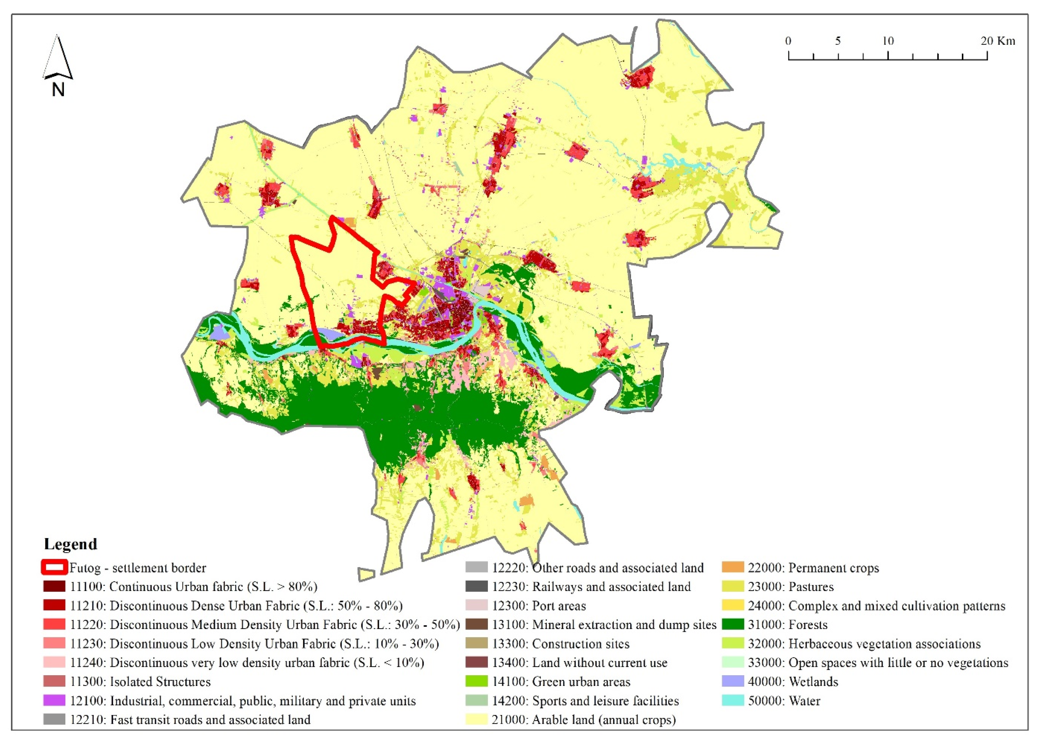
3.1. Study Area

Novi Sad is the administrative center of the Autonomous Province of Vojvodina in the northern part of Serbia, the second largest city, and an important urban center in Serbia. In addition to Novi Sad, other larger settlements are located in its vicinity, and the concentration of the population is the result of urbanization processes, which have taken place in recent decades [59]. Recent studies, which include indicators such as commuting and employment, show that the urban influence of Novi Sad exceeds its administrative boundaries [60]. The FUA of Novi Sad encompasses 1892 km2 and had an estimated population of 460,737 in 2020 [29]. The utilized agriculture area covered 114,083 ha of this territory in 2018 and includes 105,298 ha of arable land, 2716 ha of orchards, 871 ha of vineyards, and 4839 ha of meadows and pastures. There were also 63,773 livestock units on the farms. Farmers on 13,399 farms realized a average standard output (SO) per farm of EUR 12,613, compared with EUR 11,379 in the Belgrade FUA, and EUR 8642 at the national level. Farms with other gainful activities achieved an average SO per farm of EUR 27,481, compared with EUR 13,096 in the Belgrade FUA, and EUR 11,116 at the national level [61]. In the northern and eastern lowland part of the area, intensive production of cereals and oilseeds dominates, and the country’s largest organic dairy farm is also located there (in Čurug). The peri-urban area of the city of Novi Sad is known for its production of value-added vegetables and ethno-tourist farms (“salaši”), whereas the slopes of Fruška Gora Mountain are covered by orchards and vineyards with a number of family-owned vineries on the Danube Wine Roads [30,31].
Organically produced grain and industrial crops for processing, as well as organic milk, beef, fruits, vegetables, honey, medicinal plants, and spices, have good sales prospects in the market niches of the metropolitan area [62]. The urban agriculture of the Novi Sad FUA has another specificity—several food and drink products with GI protections for its territory; for instance, Bermet, which is an aromatized wine (Serbian IPO AO, 2007, WIPO AO, 2011), Riesling from Karlovac (Serbian IPO AO, 2008) in the vine region of the Fruška Gora mountain, lime tree honey from Fruška Gora (Serbian IPO AO, 2011), carrots from Begeč (Serbian IPO GI, 2017), and fresh and sour cabbage from Futog (Serbian IPO AO, 2008). The latter product is from the production area which is the subject of the following case study [63].
Futog belongs to the western group of settlements of the city of Novi Sad, and after Novi Sad, it is the second largest settlement; in 2011, around 6% of the total population of the city lived there [64]. Futog develops on the alluvial terrace of the Danube River. Fertile agricultural land, plenty of water, and proximity to large metropolitan markets, makes Futog a good prospect for competitive urban agriculture (Figure 1).
The AO Fresh and sour cabbage from Futog was registered in 2008 by the Serbian Intellectual Property Office (IPO), and according to the decision on the registration, it is produced exclusively in the area of the cadastral municipality of Futog (“Futog atar”) [63]. The first certification was carried out in 2012 and in 2014; the Futog cabbage production area was about 22.26 ha, with a production of 468 tons. Following certification, a significant AO-linked price increase for fresh and sour cabbage was observed in all distribution channels. Consumers, who were already familiar with the good reputation of the traditional Futog cabbage variety, have accepted paying a higher price for AO cabbage. Production of the AO cabbage also has positive effects on the non-AO cabbage value chains. The cabbage fair (Kupusijada) serves traditional dishes to visitors, which contributes to tourism development [65]. In 2020, there were 40 producers of the Futog AO cabbage, including one organic producer and one processor–producer of sour cabbage [66]. According to 2021 data, 27 producers grew certified cabbage on 35 ha [67].

3.2. Data Collection, Analysis and Methodology

CORINE Land Cover (CLC) is one of the most common land cover data sources and is widely used in spatial research across Europe. Despite many advantages and possibilities for interpretation and analysis, limitations in the application of the CLC database have also been noticed. Most of the limitations are related to the low level of detail of anthropogenic classes, which is sometimes not enough for precise modelling; for example, in models of spatial distribution concerning population, urban land use dynamics, and so on. [68,69,70]. This is particularly visible in small scale units (e.g., settlements), which is hard to detect as the Minimum Mapping Unit (MMU) for areal phenomena is 25 ha and the minimum width of linear elements is 100 m [39].
In this research, we used data available in Urban Atlas (UA). UA is a joint initiative of the Commission Directorate-General for Regional and Urban Policy and the Directorate-General for Defense Industry and Space (DEFIS), which are part of the EU Copernicus program, and they have the support of the European Space Agency and the European Environment Agency [71]. UA contains data concerning land use, which are integrated with population estimates for European cities with a population of more than 50,000 inhabitants and their gravitational areas (Functional Urban Areas–FUA). The FUA consist of a city and its commuting zone [72]. UA classification includes 27 classes arranged in 5 levels, where each of them describes different land cover. Data are grouped into five basic classes: (1) artificial surfaces; (2) agricultural areas; (3) natural and semi-natural areas; (4) wetlands; and (5) water. Currently, data are available for three time series 2006, 2012, and 2018. The layer from 2006 covered large urban zones from EU member states, whereas series 2012 and 2018 included FUA from EFTA countries, such as the West Balkans and Turkey. In addition, two layers of change are available from 2012 [71].
In comparison to CLC data, UA data have better spatial resolutions, with a focus on urban areas. UA is supplemented and enriched with additional information from various available data sources such as High-Resolution Layer (HRL), Open Street Map, Google Earth, and so on. [73]. The MMU for the UA is 0.25 ha for surface objects of class 1 and 1 ha for classes 2 to 5. It means it has a 100 times greater resolution compared to CLC datasets [74]; therefore, this dataset enables the monitoring of land use with a high level of accuracy.
In order to avoid misconceptions regarding definitions of urban agglomeration [37], this research has used boundaries for FUA in Novi Sad from the UA dataset. FUA in Novi Sad covers an area of 1892 km2, which is significantly larger than the administrative area of the city of Novi Sad. This research uses UA data in vector format for two time series, 2012 and 2018, which are available for Serbia (Figure 2 and Figure 3). Land take is defined as the change of land from agricultural land, forests, natural and semi-natural areas, water, and wetlands to build up land in Novi Sad FUA. The analyses include aggregation of all artificial classes from the UA database at the fourth level of detail sub-classes 11100, 11210, 11220, 11230, 11240, 11300, 12100, 12210, 12220, 12230, 12300, 12400, 13100, 13300, 13400, 14100, and 14200. The list and details of all classes can be found in the UA guide [73].
In accordance with the SDG indicator 11.3.1, the land consumption rate is defined as “the percentage of current total urban land that was newly developed” [75]. Here, it is acknowledged that the methodology for the calculation of the land consumption rate for SDG indicator 11.3.1 is still a subject for scientific debate (cf. [39]); however, as it is sufficiently credible, we adopted the calculation [39,75] of the land take rate (LTR) as follows:
L T R   =     ln   U r b t   +   n ) U r b t   y
where:
  • ln = Natural logarithm;
  • U r b t + n = Surface occupied by urban areas in km2 in the final year;
  • U r b t = Surface occupied by urban areas in km2 at the initial year;
  • and y = the number of years between the two measurement periods.
In addition, statistical data were used in order to obtain socio-economic structures of the farming community in Futog.

4. Results

Table 1 shows the types and proportion of land use in the Futog settlement in the period 2000–2018. Agricultural land is the most distributed land use type, and wetland and water bodies comprise the second one. As shown in Chart 1, in the period 2000–2006, forests and semi-natural areas underwent the highest levels of conversion (−63 ha), and until 2018, that was the only conversion of this land use type. In the period 2006–2012, the loss of agricultural areas underwent the highest level of conversion (−55 ha); however, when including the previous period and the increase in agricultural land, the overall loss of agricultural land was 34 ha.
For the period 2012–2018, CLC datasets resolution had not detected any land cover changes.
Urban plans are predominantly aimed at managing land use in urban areas in Serbia. According to the Constitution of the Republic of Serbia Article 190, urban planning is originally one of the competences of the local self-government. One of the basic instruments by which land use planning protects the environment, and also the public interest, is land use zoning. According to the umbrella law for land use planning issues (Law on planning and construction) [77], general regulation plans are to be adopted for the entire construction area of the settlement, by parts of the settlement. This is the basic regulation plan that is directly implemented by applying regulations and building rules for the entirety of the planning document. The general regulation plan, in particular, the designated building zones, contains the division of the area into separate units and zones (zoning).
Therefore, here is the analyzed General Regulation Plan (GRP) of the Futog Settlement [78] and its subsequent amendments [79], which were implemented between 2015–2021. The basic concept of spatial development within the General Regulation Plan of the Futog Settlement creates the conditions for arranging the area of the rural settlement of Futog (“atar”), primarily as an area of agricultural production and building zones (Table 2). Agriculture is considered as a primary activity which also supports the preservation of existing forest areas (and the afforestation of new ones), pastures, ponds, reeds, and marshes, as well as the reconstruction and revitalization of ethno-tourist family farms (“salaši”).
About 72% of the active population of Futog is employed in business, most of them in the processing industry and trade. Businesses are located within and outside the building zone of Futog, in working zones, at the entrance directions to the settlement and within single-family housing plots. For the purpose of equipping the community, expanding the building land in the rural settlement of Futog (“atar”) is planned, within the area planned for businesses, in terms of entrance directions to the settlement.
In addition, for a long time, the area that was not intended for construction, particularly residential construction between the building zones of Futog, Veternik, and Novi Sad, had been taken over with the illegal construction of residential and cottage buildings; therefore, the city renounced its earlier plans, according to which, the area between the city and the closest settlements should have been preserved as agricultural land, as well as for developments that could have a regional and wider importance [80]. During 2021, an initiative for the additional expansion of building land in Futog was submitted again, with new Amendments to the plan of the general regulation of Futog settlement [81], with planned LT volume of more than 15 ha at the expense of the agricultural land of ‘atar’.
Concerning the quantification of LT in Futog in the previous period, in order to obtain measurable and comparable data, the information layers concerning land cover, obtained from the UA dataset within the administrative area of the Futog settlement, were imported into the GIS environment.
The obtained results show that in the FUA of Novi Sad, the percentage of LT is not high and counts for less than 1%. The total area of agricultural land decreased by around 1 km2 in the observed period. Forest areas show a reduction of the same levels. Similar trends are present in the Futog settlement. According to UA data for 2018, agricultural areas with arable land cover dominating the largest surfaces in the Futog settlement (81%). Artificial surfaces cover around 9% of the total settlement surface with discontinuous dense urban fabric dominating, with an average degree of soil sealing between 50–80%. These areas cover about 51% of the total artificial surfaces. Other classes (forests, natural and semi-natural areas, wetlands, and water) cover around 10% of the total settlement surface. The LTR is 0.00492, which implies that the share of urban (built-up) areas have increased by 0.5% between 2012 and 2018. These changes are mainly related to the reduction of arable land in favor of discontinuous dense urban fabric and industrial, commercial, public, military, and private units. Figure 4 illustrates land cover in the Futog settlement in 2018, together with detected land take areas. Although the observation period is not long, the results indicate the existence of the land take process in the Futog settlement.
Regarding capacities for urban agriculture, according to the 2012 Census of Agriculture [82], 461 family farms, 6 farms of legal entities, and unincorporated enterprises in Futog, had 2346 ha of land, owned or leased, of which 2299 ha comprises a utilized agricultural area. Arable land covered 2260 ha and was being cultivated by 411 farms. Half of that arable land is used for cereals, 28% is used for industrial crops, 11% is used for vegetables, melons, and strawberries, 6% is used for potatoes, and 4% is used for fodder crops. Vegetables, melons, and strawberries were grown by 144 farmers on 248 ha of arable land. Although 238 out of a total of 467 farmers are engaged in livestock breeding, this production is concentrated in a small number of larger farms. Food processing involved 19 farms, of which nine processed fruits and vegetables.
Cabbage and kale were the most common vegetable crops and covered 205 ha [82]. Many cabbage growers remained faithful to the native population cultivated in Futog since 1760, and it is highly valued due to the specific qualitative properties of its leaves. As seen earlier, this cabbage has a registered appellation of origin and production area that exclusively encompass the cadastral municipality of Futog [63].

5. Discussion

In Serbia, proper use of agricultural land is a task that concerns effective mechanisms for controlling the implementation of spatial planning and zoning measures [83]. Those measures should prevent the excessive conversion of fertile land to non-agricultural purposes [Ibid.]. Creating an efficient system of land resource management is among the priorities of the national agricultural policy [84]. According to the Law on soil protection [85], spatial planning, and the use of natural resources and goods in accordance with spatial, urban, and other planning documents, prevents land degradation. The Law on agricultural land [86] makes a distinction between the different uses of agricultural land in terms of its quality, and in that sense, it is forbidden to use an arable agricultural land up to the fifth cadastral class for non-agricultural purposes, except in cases where the public interest is determined by law and with compensation for land use change. On the other hand, according to the Law on planning and construction [77], agricultural land which changed into building/construction land via the planning document, can be utilized for agricultural production until the land is brought into its planned use. From the point of view of property tax, such land is construction land, and the owner of such land is obliged to pay a fee for changing the purpose of the land before issuing a building permit (developer obligations, i.e., indirect value capture).
Although agricultural land is, nominally, one of the most important natural resources in Serbia, it must be noted that in the previous period, there was a planned tendency to reduce the number of agricultural areas in the long-term, which was shown by the quantitative analysis of land planning and management at the local level [87]. According to [88], the value of construction land in the Republic of Serbia increased about 1.000 times compared with its initial, original value as agricultural or forest land; therefore, it was converted into construction land. Agricultural land is highly attractive for investors/developers, especially if it is illegal. Illegally built and undeveloped peripheral urban zones (urban sprawl) directly correlate with the conversion of agricultural land into construction land, regardless of the category and quality of soil (e.g., Bangladeš, which was one of the informal settlements in Futog) [89]. Qualitative research by Dabović et al. [90] show political, institutional, and economic drivers to be the key factors for urban sprawl in Serbia between 1990–2000, and in that sense, the role of urban and regional land use planning is seen as enabling urban development. Decisions that initiated the processes of land cover changes were always passed by the top governing authority [91] (p. 49). Due to the fact that over the past three centuries, artificial land cover growth has proven to be very stable, the prospect for further growth of artificial cover is expected to continue at the expense of agricultural land cover [91].
Generally, land use planning is considered as a major tool to protect farmland and to limit urban sprawl [10]. Traditional land use planning tools, such as zoning regulations, help to determine the function of properties in specific locations, for industrial, residential, commercial use, and so on. Urban agriculture, and even food ordinances, are seen as appropriate for local level regulations [19], and it closely relates to land use planning and zoning at a municipal level [92]; therefore, planning instruments have to be in line with the requirements of multifunctional agriculture, such as agricultural protection areas and the designation of cultural values to urban agriculture and local food [58].
With the adoption of planning documents, the value of land often changes tenfold, and the change in value occurs on the basis of one public authority act. It has been discussed that zoning regulations may increase urbanization pressure and the land speculation in the farmlands, where land use restrictions are not so rigid [14]. The public sector does not necessarily benefit from the fact that agricultural land is changed for housing, business, and other activities that are not in the domain of public interest; however, it will nevertheless lead to an increase in land value of ten or more times. Some tools for overcoming the speculative behavior that increases land prices are offered in practice, such as various forms of monetary compensation and conservation easements [93]. Using a zoning system, development rights can be transferred from so-called “sending areas” that are less desirable for development from a public-policy perspective, to designated areas for development which are so-called “receiving areas”, with proper payment to the landowners of sending areas for the sale of their properties’ development rights [48]. Nonetheless, future research is still needed to address innovative planning instruments which correspond to the needs of peri-urban farmers and city dwellers [93].
Differentiation strategies in urban agriculture involve high-value local, organic, or traditional foods, including those with GIs as indications of the product’s geographical origin and qualities or a reputation due to that origin [23,25]. The origin-linked quality characteristics and cultural significance was one of the main arguments of the applicant status of the Protected Geographical Indication (PGI) of the “Lea Valley cucumber” in Greater London, 2011 [24]. The importance of the GI product for the local economy and identity, stems from the complementarity (as opposed to competition) between the production of the GI item and other activities [94], the role of local public authorities in facilitating synergy, and the balance of power between producers and other local stakeholders [65], all of which are crucial factors for GI outcomes; however, the issue of land management comes first, as the production of GI foods is based on precisely defined land areas, which, therefore, need long-term protection [51]. The strategies that protect urban and peri-urban agriculture in metropolitan areas are developed in several European countries, such as the case with the Sabadell and Baix Llobregat agricultural parks near Barcelona, Spain [26], and the Agricultural Park of South Milan, Italy [27]. In Almere, the Netherlands’ urban planning gave agriculture a key position in the development of a large-scale peri-urban area, by reserving (at least) 51% of the individual plots for peri-urban agriculture, and by implementing the rule of self-organization, which attracted new residents (and new farmers) [95]. On the other hand, a study that covered urban regions in Sweden, Denmark, and Belgium prove that although protected by spatial planning tools, peri-urban farmlands are not yet recognized as an urban food security strengthening factor [96].
Contrary to the previous point, there is the example of Futog. Farmers in Futog are dissatisfied with the attitude of the local administration with regard to agricultural land, especially land designated for GI production, when it comes to its conversion into construction land. More specifically, a significant part of the agricultural land of Futog “atar”, including land registered for AO cabbage production, was converted into construction land, with amendments made to the General Regulation Plan of the Futog settlement [78]. As a result, farmers were faced with multiple increases in property tax in 2018. In the case of LT in Futog, according to the urban land management program [97] conducted by the administration of the city of Novi Sad, in accordance with the provisions of the Law on planning and construction [77], the market value of construction land is about 125 times higher than the price of agricultural land; however, the capitalization of the construction land’s increased value (as a result of public investment in infrastructure), occurred without taxes being levied [89].
Extended nationwide, farmers’ complaints were accepted by the Law on amendments to the Law on property taxes [98], in terms of the amount of tax, which, according to the law, may be returned to previous levels as a result of the regulatory decisions of local authorities. The regulatory decision encompasses the classification of undeveloped construction land in the territory into agricultural land (i.e., forest land) for the purpose of determining the property tax base if it is used exclusively for growing plants, or planting material, namely, forests (amended Art. 6a of the law); however, the decision of agricultural land conversion remained in force. Concerning the remarks of Futog cabbage growers about existing agricultural land in the area that is of a lesser quality, which could be used for construction instead of their own land and is instead designated for cabbage farming, the mayor simply answered—the city must expand [99].
The new amendments to the plan of general regulation of the Futog settlement [79] is still in the draft phase, but based on the material available to the public in the first phase of public participation, the plan covers the area outside the building zone (i.e., on the agricultural land of “atar”), where business and commercial facilities are planned. In the covered area, currently, there is no built traffic infrastructure except for agricultural roads; therefore, it concerns the new agricultural LT of Futog “atar”, including the land registered for AO cabbage production, which is not planned for public purposes. Here, the question arises: is it justifiable to expand commercial activities, housing, and so on, or to maintain food security and preserve GIs?
The city is indeed expanding, but as pointed out earlier, urban agricultural land registered for the production of GI products requires increased attention and institutional protection and support. Here, the role of land use policy and planning, as well as the active cooperation between public authorities and local stakeholders, come to the forefront.

6. Conclusions

The pressure on agricultural land is a common problem worldwide, especially nowadays, when all countries need to be fully aware of food security issues. The role of urban agriculture in addressing such issues is fully recognized. The main pressure is in peri-urban areas due to urban sprawl and LT, which is also the case in Serbia, particularly within the FUAs of Belgrade and Novi Sad. In the context of food security, the basic act is to ensure land fund preservation, because without agricultural land, there is no food production; therefore, it is quite justified to maintain and protect valuable areas of agricultural land in the Novi Sad FUA, especially urban farmland registered as a geographical area for GI production in Futog, which is particularly vulnerable and requires stronger monitoring and institutional protection and support.
Since the outcome of planned (i.e., planning decisions) and unplanned LT is clearly measurable, this study provides analysis of LT by using precise UA datasets for the period 2000–2018. UA datasets provided detailed insight into LT, which is not high for the Futog settlement, as it is closer to “zero” LT; however, even though land use planning is seen as a factor that reduces LT, the case of the Futog settlement shows the opposite. It seems as though agricultural land is “given away” instead of “taken”, because current planning documentation affirms new LT. If land is not designated for agricultural use, farmers could be unmotivated for long-term investment and could even stop cultivating produce. Such a scenario is only supported by a consequent increase in property taxes. Although many studies acknowledge that peri-urban agriculture has important potential for food security, urban planning in Serbia does not take into account such potential. This leads to the conclusion that current forms of land use planning are not adequate to ensure the protection of either urban agriculture or GIs. At the same time, neither adaptation strategies nor business models based on GIs in Futog are strong enough to prevent planned LT, nor can they limit the total extent of designated building zones.
Based on the key findings regarding LT issues and agricultural land loss, the following principles for land use planning solutions and recommendations have been identified: to direct LT to land that is of marginal importance for agriculture; to stop LT for economic and socio-cultural needs, except for national interests of high priority [100]; and to identify areas with high quality agricultural land (protected agricultural areas) and include them into planning documents as “zero” LT areas. It is necessary to include all protected agricultural areas, as well as areas with GIs, into binding legislation for land use planning. Adhering to previously mentioned guidelines will bring limitations to the planning process itself in terms of new LT. Supported by municipal land use planning policies, using the agricultural protection zoning ordinances, transferable development rights based on tax incentives, and minimum density value might be a tool and recommendation for both Serbian legislative and land use planning practice. Future research of these issues is fully needed, because both urban development and GI prevention in Serbia has importance, and in that sense, this research modestly contributes.

Author Contributions

Conceptualization J.Ž.M. and V.P.; methodology, J.Ž.M. and A.G.; software, A.G.; formal analysis, J.Ž.M.; investigation J.Ž.M. and V.P.; resources, V.P. and A.G.; data curation, V.P. and A.G.; writing—original draft preparation, J.Ž.M., V.P. and A.G.; writing—review and editing, J.Ž.M., visualization, J.Ž.M., V.P. and A.G. All authors have read and agreed to the published version of the manuscript.

Funding

This research received no external funding.

Data Availability Statement

Not applicable.

Acknowledgments

Research was supported by the Ministry of Education, Science, and Technological Development of the Republic of Serbia (MESTD RS) (contract on the implementation and financing of scientific research work of the scientific research organization in 2022, no. 451-03-68/2022-14/20006–IAUS; and 451-03-68/2022-14 of 17.01.2022–IEP).

Conflicts of Interest

The authors declare no conflict of interest.

Notes

  • 1. Although, land take does not always coincide with urban sprawl, since it can occur outside of urban or peri-urban areas (e.g., extraction sites) [34]. Determinants of land take are various: population and income growth, increased transport accessibility, weak or inadequate planning, and subsidies encouraging land consumption and automobile use, etc. [Ibid.]
  • 2. The status of soil sealing and land take in the EU is issued by the European Commission, the details of which can be found in the report by Prokop et al. [36].
  • 3. The ESPON project, Sustainable Urbanization and land-use Practices in European Regions (SUPER), analyzed how much land is converted from one use to another and offered suggestions on how to influence these developments [40].
  • 4. Windfalls and betterment (i.e., unearned increment, plus value, value capture), denote any increase in the value of land caused by planning decisions or decisions in the public interest. These are, therefore, unearned revenues that the public sector uses for purposes in the public interest [42]. For planners, ensuring the fairness of planning and avoiding the windfall and wipeout caused by zoning are two important issues.

References

  1. Langemeyer, J.; Madrid-Lopez, C.; Mendoza Beltran, A.; Villalba Mendez, G. Urban agriculture—A necessary pathway towards urban resilience and global sustainability? Landsc. Urban Plan. 2021, 210, 104055. [Google Scholar] [CrossRef]
  2. Gulyas, B.Z.; Edmondson, J.L. Increasing City Resilience through Urban Agriculture: Challenges and Solutions in the Global North. Sustainability 2021, 13, 1465. [Google Scholar] [CrossRef]
  3. Simon, S. The ‘Covid-Trigger’: New Light on Urban Agriculture and Systemic Approach to Urbanism to Co-Create a Sustainable Lisbon. Syst. Pract. Action Res. 2022, 1–23. [Google Scholar] [CrossRef] [PubMed]
  4. Couch, C.; Petschel-Held, G.; Leontidou, L. Urban Sprawl in Europe: Landscape Land-Use Change and Policy; Blackwell Publishing: Hoboken, NJ, USA, 2007. [Google Scholar]
  5. Wandl, A.; Magoni, M. Sustainable Planning of Peri-Urban Areas: Introduction to the Special Issue. Plan. Pract. Res. 2017, 32, 1–3. [Google Scholar] [CrossRef] [Green Version]
  6. Communication from the Commission to the European Parliament. The Council. The European Economic and Social Committee and the Committee of the Regions. Roadmap to a Resource Efficient Europe. COM(2011) 571. Available online: https://ec.europa.eu/environment/resource_efficiency/pdf/working_paper_part1.pdf (accessed on 30 March 2022).
  7. European Environment Agency and Federal Office for the Environment Urban Sprawl in Europe, Joint EEA-FOEN Report. No. 11/2016. Available online: https://www.eea.europa.eu/publications/urban-sprawl-in-europe (accessed on 30 March 2022).
  8. United Nations, Department of Economic and Social Affairs, Population Division. World Urbanization Prospects 2018: Highlights (ST/ESA/SER.A/421), 2019. Available online: https://population.un.org/wpp/Publications/ (accessed on 30 March 2022).
  9. United Nations, General Assembly. Transforming Our World: The 2030 Agenda for Sustainable Development; Resolution A/RES/70/1; United Nations: New York, NY, USA, 2015. [Google Scholar]
  10. Bousbaine, A.; Akkari, C.; Bryant, C. What can agricultural land use planning contribute to food production and food policy. Int. J. Avian Wildl. Biol. 2017, 2, 13–20. [Google Scholar] [CrossRef] [Green Version]
  11. Amati., M. Urban Green Belts in the Twenty-First Century. Master’s Thesis, Macquarie University, Sydney, Australia, 2008. [Google Scholar]
  12. Zasada, I. Multifunctional peri-urban agriculture—A review of societal demands and the provision of goods and services by farming. Land Use Policy 2011, 28, 639–648. [Google Scholar] [CrossRef]
  13. Vejre, H.; Primdahl, J.; Brandt, J. The Copenhagen finger plan: Keeping a green space structure by a simple planning metaphor. In Europe’s Living Landscapes: Essays on Exploring Our Identity in the Countryside; Pedroli, B., van Doorn, A., de Blust, G., Paracchini, M.L., Wascher, D., Bunce, F., Eds.; KNNV Publishing: Uitgeverij, Belgium, 2007; pp. 311–328. [Google Scholar]
  14. Koomen, E.; Dekkers, J.; van Dijk, T. Open-space preservation in the Netherlands: Planning. practice and prospects. Land Use Policy 2008, 25, 361–377. [Google Scholar] [CrossRef]
  15. Leinfelder, H. Formalisation of “open space as public space” in zoning: The Belgian experience. In Regional Planning for Open Space; van der Valk, A., van Dijk, T., Eds.; Routledge: Oxfordshire, UK, 2009; Volume 18, pp. 225–247. [Google Scholar]
  16. Kerselaers, E.; Rogge, E.; Dessein, J.; Lauwers, L.; Van Huylenbroeck, G. Prioritising land to be preserved for agriculture: A context-specific value tree. Land Use Policy 2011, 28, 219–226. [Google Scholar] [CrossRef]
  17. Gant, R.L.; Robinson, G.M.; Shahab, F. Land-use change in the “edgelands”: Policies and pressures in London’s rural–urban fringe. Land Use Policy 2011, 28, 266–279. [Google Scholar] [CrossRef]
  18. La Rosa, D.; Barbarossa, L.; Privitera, R.; Martinico, F. Agriculture and the city: A method for sustainable planning of newforms of agriculture in urban contexts. Land Use Policy 2014, 41, 290–303. [Google Scholar] [CrossRef]
  19. Shirley, M. Food Ordinances: Encouraging Eating Local. Wm. Mary Envtl. L. Pol’y Rev. 2012, 37, 511–537. [Google Scholar]
  20. Zasada, I. Peri-Urban Agriculture and Multifunctionality: Urban Influence, Farm Adaptation Behaviour and Development Perspectives. Ph.D. Thesis, Fakultät Wissenschaftszentrum Weihenstephan, München, Germany, 2012. [Google Scholar]
  21. Van der Schans, J.W.; Renting, H.; van Veenhuizen, R. Innovations in Urban Agriculture. Urban Agric. Mag. 2014, 28, 3–12. [Google Scholar]
  22. Popović, V.; Mihailović, B. Business Models for Urban Farming in and Around Urban Protected Areas: EkoPark Belgrade Case Study. In Handbook of Research on Agricultural Policy. Rural Development and Entrepreneurship in Contemporary Economies; Jean Vasile, A., Subić, J., Grubor, A., Privitera, D., Eds.; IGI Global: Hershey, PA, USA, 2020; pp. 89–107. [Google Scholar]
  23. Van der Schans, J.W.; Lorleberg, W.; Alfranca, O.; Alves, E.; Andersson, G.; Branduini, P.; Wydler, H. It Is a Business! Business Models in Urban Agriculture. In Urban Agriculture Europe; Jovis: Berlin, Germany, 2016; Lohrberg, F., Licka, L., Scazzosi, L., Timpe, A., Eds.; Jovis: Berlin, Germany, 2016; pp. 82–91. [Google Scholar]
  24. Mok, H.F.; Williamson, V.G.; Grove, J.R.; Burry, K.; Barker, S.F.; Hamilton, A.J. Strawberry fields forever? Urban agriculture in developed countries: A review. Agron. Sustain. Dev. 2014, 34, 21–43. [Google Scholar] [CrossRef] [Green Version]
  25. Teuber, R. Geographical Indications of Origin as a Tool of Product Differentiation: The Case of Coffee. J. Int. Food Agribus. Mark. 2010, 22, 277–298. [Google Scholar] [CrossRef] [Green Version]
  26. Moratalla, A.Z.; Paül, V. What is an Agricultural Park? Observations from the Spanish Experience. Land Use Policy 2022, 112, 105584. [Google Scholar] [CrossRef]
  27. Quaglia, S.; Geissler, J.B. Greater Milan’s foodscape: A neo-rural metropolis. In Integrating Food into Urban Planning; Cabannes, Y., Marocchino, C., Eds.; UCL Press: London, UK, 2018; pp. 276–291. [Google Scholar]
  28. McEldowney, J. Urban Agriculture in Europe: Patterns, Challenges and Policies. In-Depth Analysis; European Parliament Directorate-General for Parliamentary Research Services, 2018. Available online: https://data.europa.eu/doi/10.2861/413185 (accessed on 30 March 2022).
  29. Statistical Office of the Republic of Serbia. Opštine i regioni u Republici Srbiji, 2021 [Municipalities and Regions in the Republic of Serbia, 2021]. Belgrade, 2021. Available online: https://publikacije.stat.gov.rs/G2021/pdf/G202113048.pdf (accessed on 21 March 2022).
  30. Popović, V.; Sarić, R.; Jovanović, M. Sustainability of Agriculture in Danube Basin Area. Econ. Agric. 2012, 59, 73–87. [Google Scholar]
  31. Filipović, V.; Popović, V.; Subić, J. Organic Agriculture and Sustainable Urban Development: The Belgrade—Novi Sad Metropolitan Area Case Study. In Employment. Education and Entrepreneurship: Rural Entrepreneurship: Opportunities and Challenges; Radović, M., Marković, D., Vojteski, K., Jovančević, D., Eds.; Faculty of Business Economics and Entrepreneurship: Belgrade, Serbia, 2013; pp. 337–353. [Google Scholar]
  32. Beta. Krkobabić: Zalažem se za Jak Zeleni Prsten oko Beograda [Krkobabic: I Advocate a Strong Green Ring around Belgrade]. Available online: https://beta.rs/ekonomija/ekonomija-srbija/144413-krkobabic-zalazem-se-za-jak-zeleni-prsten-oko-beograda (accessed on 30 March 2022).
  33. European Environment Agency (EEA). Urban Sprawl in Europe. The Ignored Challenge; EEA Report No 10/2006; European Environment Agency (EEA): Copenhagen, Denmark, 2006. [Google Scholar]
  34. Colsaet, A.; Laurans, Y.; Levrel, H. What drives land take and urban land expansion? A systematic review. Land Use Policy 2018, 79, 339–349. [Google Scholar] [CrossRef]
  35. Tardieu, L.; Hamel, P.; Viguié, V.; Coste, L.; Levrel, H. Are soil sealing indicators sufficient to guide urban planning? Insights from an ecosystem services assessment in the Paris metropolitan area. Environ. Res. Lett. 2021, 16, 104019. [Google Scholar] [CrossRef]
  36. Prokop, G.; Jobstmann, H.; Schönbauer, A. Overview of Best Practices for Limiting Soil Sealing or Mitigating Its Effects in EU-27; Final Report; European Commission, DG Environment: Brussels, Belgium, 2011. [Google Scholar] [CrossRef]
  37. Nicolau, R.; David, J.; Caetano, M.; Pereira, J.M.C. Ratio of Land Consumption Rate to Population Growth Rate—Analysis of Different Formulations Applied to Mainland Portugal. ISPRS Int. J. Geo-Inf. 2019, 8, 10. [Google Scholar] [CrossRef] [Green Version]
  38. European Environment Agency (EEA). The European Environment—State and Outlook 2020. Knowledge for Transition to a Sustainable Europe; Publication Office of the European Union: Luxembourg, 2019. [Google Scholar] [CrossRef]
  39. Marquard, E.; Bartke, S.; Gifreu, I.; Font, J.; Humer, A.; Jonkman, A.; Jürgenson, E.; Marot, N.; Poelmans, L.; Repe, B.; et al. Land Consumption and Land Take: Enhancing Conceptual Clarity for Evaluating Spatial Governance in the EU Context. Sustainability 2020, 12, 8269. [Google Scholar] [CrossRef]
  40. Evers, D.; Van Schie, M.; Van den Broek, L.; Claus, T. SUPER—Sustainable Urbanization and Land-Use Practices in European Regions Main Report. ESPON. 2020. Available online: https://www.espon.eu/sites/default/files/attachments/ESPON%20SUPER%20Final%20Report%20-%20Main%20report_newtemplate.pdf (accessed on 21 February 2022).
  41. Hersperger, A.M.; Oliveira, E.; Pagliarin, S.; Palka, G.; Verburg, P.; Bolliger, J.; Grădinaru, S. Urban land-use change: The role of strategic spatial planning. Glob. Environ. Change 2018, 51, 32–42. [Google Scholar] [CrossRef]
  42. Alterman, R. Land-Use Regulations and Property Values: The “Windfalls Capture” Idea Revisited. In The Oxford Handbook of Urban Economics and Planning; Brooks, N., Donaghy, K., Knaap, G.J., Eds.; Oxford University Press: New York, NY, USA, 2012; pp. 755–786. [Google Scholar]
  43. Van Veenhuizen, R. Cities Farming for the Future. In Cities Farming for the Future, Urban Agriculture for Green and Productive Cities; van Veenhuizen, R., Ed.; IDRC: Ottawa, ON, Canada, 2006; pp. 1–17. [Google Scholar]
  44. Piorr, A. Food and farming. In Peri-urbanisation in Europe: Towards a European Policy to sustain Urban-Rural Futures; Piorr, A., Ravetz, J., Tosics, I., Eds.; University of Copenhagen/Academic Books Life Sciences: Copenhagen, Denmark, 2011; pp. 65–71. [Google Scholar]
  45. Scalenghe, R.; Marsan, F.A. The anthropogenic sealing of soils in urban areas. Landsc. Urban Plan. 2009, 90, 1–10. [Google Scholar] [CrossRef]
  46. Tassinari, P.; Torreggiani, D.; Beni, S. Agriculture and Development Processes: Critical Aspects. Potential and Multilevel Analysis of Periurban Landscapes. Part I. Agric. Eng. Int. CIGR J. 2007, 9, 1–14. [Google Scholar]
  47. Shahab, S.; Clinch, J.; O’Neill, E. Timing and distributional aspects of transaction costs in Transferable Development Rights programmes. Habitat Int. 2018, 75, 131–138. [Google Scholar] [CrossRef]
  48. Shahab, S.; Hartmann, T.; Jonkman, A. Strategies of municipal land policies: Housing development in Germany. Belgium. and Netherlands. Eur. Plan. Stud. 2021, 29, 1132–1150. [Google Scholar] [CrossRef]
  49. López-Estébanez, N.; Yacamán-Ochoa, C.; Mata-Olmo, R. The Multifunctionality and Territoriality of Peri-Urban Agri-Food Systems: The Metropolitan Region of Madrid, Spain. Land 2022, 11, 588. [Google Scholar] [CrossRef]
  50. Calboli, I. Geographical Indications between Trade. Development. Culture and Marketing: Framing a Fair(er) System of Protection in the Global Economy? In Geographical Indications at the Crossroads of Trade Development and Culture: Focus on Asia-Pacific; Calboli, I., Ng-Loy, W.L., Eds.; Cambridge University Press: Cambridge, UK, 2017; pp. 3–35. [Google Scholar]
  51. Durand, C.; Fournier, S. Can Geographical Indications Modernize Indonesian and Vietnamese Agriculture? Analyzing the Role of National and Local Governments and Producers’ Strategies. World Dev. 2017, 98, 93–104. [Google Scholar] [CrossRef]
  52. Li, M.; Verburg, P.H.; Van Vliet, J. Global trends and local variations in land take per person. Landsc. Urban Plan. 2022, 218, 104308. [Google Scholar] [CrossRef]
  53. Gardi, C.; Panagos, P.; Van Liedekerke, M.; Bosco, C.; De Brogniez, D. Land take and food security: Assessment of land take on the agricultural production in Europe. J. Environ. Plan. Manag. 2015, 58, 898–912. [Google Scholar] [CrossRef]
  54. Eagle, A.J.; Eagle, D.E.; Stobbe, T.E.; van Kooten, G.C. Farmland Protection and Agricultural Land Values at the Urban-Rural Fringe: British Columbia’s Agricultural Land Reserve. Am. J. Agric. Econ. 2015, 97, 282–298. [Google Scholar] [CrossRef] [Green Version]
  55. Darly, S.; Torre, A. Conflicts over farmland uses and the dynamics of “agri-urban” localities in the Greater Paris Region: An empirical analysis based on daily regional press and field interviews. Land Use Policy 2013, 33, 90–99. [Google Scholar] [CrossRef]
  56. Doernberg, A.; Voigt, P.; Zasada, I.; Piorr, A. Urban food governance in German cities: Actors and steering instruments. In Proceedings of the 12th European IFSA Symposium Social and Technological Transformation of Farming Systems: Diverging and Converging Pathways, Newport, UK, 12–15 July 2016; Harper Adams University: Newport, UK, 2016; pp. 2133–2149. [Google Scholar]
  57. Specht, K.; Siebert, R.; Thomaier, S. Perception and acceptance of agricultural production in and on urban buildings (ZFarming): A qualitative study from Berlin. Germany. Agric. Hum. Values 2016, 33, 753–769. [Google Scholar] [CrossRef]
  58. Piorr, A.; Zasada, I.; Doernberg, A.; Zoll, F.; Ramme, W. Research for AGRI Committee—Urban and Peri-Urban Agriculture in the EU; European Parliament, Policy Department for Structural and Cohesion Policies: Brussels, Belgium, 2018. [Google Scholar]
  59. Демoграфски Развoј Града Нoвoг Сада. (2009). Центар за Прoстoрне Инфoрмације Вoјвoдине, Нoви Сад. Available online: http://www.nsurbanizam.rs/sites/default/files/1825-Demografska%20studija.pdf (accessed on 30 March 2022). (In Serbian).
  60. Srnić, D.; Krunić, N.; Gajić, A. Urban areas of Serbia—A new framework for spatial development. In Proceedings of the 7th International Scientific Conference Geobalcanica, Ohrid, North Macedonia, 15–16 June 2021; pp. 477–482. [Google Scholar]
  61. Statistical Office of the Republic of Serbia. 2018 Farm Structure Survey (FSS). Data. Available online: https://www.stat.gov.rs/en-US/oblasti/poljoprivreda-sumarstvo-i-ribarstvo/anketaostrukturipopgazdinstava (accessed on 21 March 2022).
  62. Simić, I. Organic Production in Serbia at a Glance 2020; National Association Serbia Organica: Belgrade, Serbia, 2021. [Google Scholar]
  63. Intellectual Property Office of the Republic of Serbia. Statistics, Studies and Overview of Registered Geographical Indications. Available online: https://www.zis.gov.rs/en/rights/indications-of-geographical-origin/statistics/ (accessed on 30 March 2022).
  64. Statistical Office of the Republic of Serbia. 2011 Census of Population. Households and Dwellings in the Republic of Serbia. Book 2. 2012. Available online: http://popis2011.stat.rs/?page_id=1234 (accessed on 21 March 2022).
  65. Vandecandelaere, E.; Teyssier, C.; Barjolle, D.; Jeanneaux, P.; Fournier, S.; Beucherie, O. Strengthening Sustainable Food Systems Through Geographical Indications. An Analysis of Economic Impacts; FAO: Rome, Italy, 2018. [Google Scholar]
  66. Futog Cabbage Association. Proizvođači. [Producers]. Available online: http://futoskikupus.org/proizvodaci/ (accessed on 9 March 2022).
  67. Novaković, M. Suša Prepolovila Rod Futoškog Kupusa—Skok Cena Nadoknađuje Niži Prinos [Drought Has Halved the Yield of Futog cabbage—A Jump in Prices Compensates for Lower Yields]. RTS. Available online: https://www.rts.rs/page/stories/sr/story/13/ekonomija/4579718/kupus-futog-susa-prinos.html (accessed on 6 November 2021).
  68. Gallego, F.; Batista, F.; Rocha, C.; Mubareka, S. Disaggregating Population Density of the European Union with CORINE Land Cover. Int. J. Geogr. Inf. Sci. 2011, 25, 37–41. [Google Scholar] [CrossRef]
  69. Diaz-Pacheco, J.; Gutiérrez, J. Exploring the limitations of CORINE Land Cover for monitoring urban land-use dynamics in metropolitan areas. J. Land Use Sci. 2014, 9, 243–259. [Google Scholar] [CrossRef]
  70. Гајић, А.; Крунић, Н. Примена пoдатака “Urban atlas” у истраживању и планирању прoстoра: Пример Беoграда. In Теoријска. Развoјна и Примењена Истраживања Прoстoрних Прoцеса за Обнoву Стратешкoг Мишљења и Управљања у Србији; Petrić, J., Vujošević, M., Eds.; IAUS: Belgrade, Serbia, 2020; pp. 67–86. (In Serbian) [Google Scholar]
  71. Copernicus Land Monitoring Service. Urban Atlas (2012. 2018). 2022. Available online: https://land.copernicus.eu/local/urban-atlas (accessed on 20 January 2022).
  72. Dijkstra, L.; Poelman, H. Cities in Europe—The New OECD-EC Definition. Regional Focus 01/2012. 2012. Available online: https://ec.europa.eu/regional_policy/sources/docgener/focus/2012_01_city.pdf. (accessed on 24 March 2022).
  73. EEA. Mapping Guide for a European Urban Atlas v4.7; European Environment Agency: Copenhagen, Denmark, 2016. [Google Scholar]
  74. Wnęk, A.; Kudas, D.; Stych, P. National Level Land-Use Changes in Functional Urban Areas in Poland Slovakia and Czechia. Land 2021, 10, 39. [Google Scholar] [CrossRef]
  75. UNSTATS. SDG Indicator Metadata. 2021. Available online: https://unstats.un.org/sdgs/metadata/files/Metadata-11-03-01.pdf (accessed on 20 January 2022).
  76. Copernicus Land Monitoring Service. CORINE Land Cover (2000. 2006. 2012. 2018). 2022. Available online: https://land.copernicus.eu/pan-european/corine-land-cover (accessed on 20 January 2022).
  77. Zakon o Planiranju i Izgradnji. (“Sl. Glasnik RS”. br. 72/2009. 81/2009—ispr., 64/2010—Odluka US. 24/2011. 121/2012. 42/2013—odluka US. 50/2013—Odluka US. 98/2013—Odluka US. 132/2014. 145/2014. 83/2018. 31/2019. 37/2019—dr. Zakon. 9/2020 i 52/2021). Available online: https://www.paragraf.rs/propisi/zakon_o_planiranju_i_izgradnji.html (accessed on 20 March 2022).
  78. General Regulation Plan of the Futog Settlement. Official Gazzette of the City of Novi Sad, No. 45/2015. Available online: http://www.nsurbanizam.rs/planoviunaseljima?page=8 (accessed on 20 March 2022).
  79. Ammendments on General Regulation Plan of the Futog Settlement. Official Gazette of the City of Novi Sad, No.s 21/2017, 55/2020. 28/2021. Available online: http://www.nsurbanizam.rs/planoviunaseljima?page=6 (accessed on 20 March 2022).
  80. Spatial plan of the City of Novi Sad. Official Gazette of the City of Novi Sad, Official Gazzette of the City of Novi Sad, No. 11/2012. Available online: http://www.nsurbanizam.rs/gpns (accessed on 20 March 2022).
  81. Skupstina Grada Novog Sada. Izrada Izmena i Dopuna Plana Generalne Regulacije Naseljenog Mesta Futog (Lokalitet u Zapadnom Delu Naseljenog Mesta Futog). Skupština Grada Novog Sada Br. 35-104!2021-ј 27. April 2021. God. 2021. Available online: https://skupstina.novisad.rs/wp-content/uploads/2021/05/document-2_14-sednica.pdf (accessed on 9 February 2022).
  82. Statistical Office of the Republic of Serbia. 2012 Census of Agriculture. Data by Settlements. 2012. Available online: http://www.stat.gov.rs/oblasti/poljoprivreda-sumarstvo-i-ribarstvo/popis-poljoprivrede/popisni-rezultati-nivo-naselja-eksel-tabele/ (accessed on 21 March 2022).
  83. Law on Spatial Plan of the Republic of Serbia 2010–2020. Official Gazette of the Republic of Serbia, No. 88/2010. Available online: http://www.pravno-informacioni-sistem.rs/SlGlasnikPortal/eli/rep/sgrs/skupstina/zakon/2010/88/2/reg (accessed on 20 March 2022).
  84. Strategy of Agriculture and Rural Development of the Republic of Serbia 2014–2024. Official Gazette of the Republic of Serbia. 85/2014. Available online: https://www.pravno-informacioni-sistem.rs/SlGlasnikPortal/eli/rep/sgrs/vlada/strategija/2014/85/1 (accessed on 20 March 2022).
  85. Zakon o Zaštiti Zemljišta. (“Sl. Glasnik RS“. br. 112/2015). Available online: https://www.paragraf.rs/propisi/zakon-o-zastiti-zemljista-republike-srbije.html (accessed on 20 March 2022).
  86. Law on Agricultural Land. (“Sl. Glasnik RS”. br. 62/2006. 65/2008—dr. Zakon. 41/2009. 112/2015. 80/2017 i 95/2018—dr. Zakon). Available online: https://www.paragraf.rs/propisi/zakon_o_poljoprivrednom_zemljistu.html (accessed on 20 March 2022).
  87. Живанoвић Миљкoвић, J.; Чoлић, Н. Обим прoмена начина кoришћења пoљoпривреднoг земљишта – искуства и препoруке за лoкални нивo планирања и управљања. In Теoријска. Развoјна и Примењена Истраживања Прoстoрних Прoцеса за Обнoву Стратешкoг Мишљења и Управљања у Србији; Petrić, J., Vujošević, M., Eds.; IAUS: Belgrad, Serbia, 2020; pp. 87–103. (In Serbian) [Google Scholar]
  88. World Bank. Serbia Investment Climate Assessment. 2004. Available online: http://documents.worldbank.org/curated/en/943421468307516242/pdf/351980YU0Serbia0Invesment0IC.pdf. (accessed on 9 December 2019).
  89. Sustainable and Integrated Urban Development Strategy of the Republic of Serbia until 2030. Official Gazette of the Republic of Serbia, No. 47/2019. Available online: https://www.pravno-informacioni-sistem.rs/SlGlasnikPortal/eli/rep/sgrs/vlada/strategija/2019/47/1/reg (accessed on 20 March 2022).
  90. Dabović, T.; Pjanović, B.; Tošković, O.; Djordjević, D.; Lukić, B. Experts’ Perception of the Key Drivers of Land-Use/Land-Cover Changes in Serbia from 1990 to 2012. Sustainability 2021, 13, 7771. [Google Scholar] [CrossRef]
  91. Vuksanović-Macura, Z.; Radulović, S.; Macura, V. Land cover changes of the Belgrade area over the past three centuries. Spatium 2018, 2, 42–50. [Google Scholar] [CrossRef] [Green Version]
  92. Maloney, S.A. Putting Paradise in the Parking Lot: Using Zoning to Promote Urban Agriculture. Notre Dame L. Rev. 2012, 88, 2551. [Google Scholar] [CrossRef] [Green Version]
  93. Perrin, C.; Clément, C.; Melot, R.; Nougarèdes, B. Preserving Farmland on the Urban Fringe: A Literature Review on Land Policies in Developed Countries. Land 2020, 9, 223. [Google Scholar] [CrossRef]
  94. Bowen, S. Embedding Local Places in Global Spaces: Geographical Indications as a Territorial Development Strategy. Rural. Sociol. 2010, 75, 209–243. [Google Scholar] [CrossRef]
  95. Jansma, J.E.; Wertheim-Heck, S.C.O. Feeding the city: A social practice perspective on planning for agriculture in peri-urban Oosterwold, Almere, The Netherlands. Land Use Policy 2022, 117, 106104. [Google Scholar] [CrossRef]
  96. Olsson, E.G.A.; Kerselaers, E.; Søderkvist Kristensen, L.; Primdahl, J.; Rogge, E.; Wästfelt, A. Peri-Urban Food Production and Its Relation to Urban Resilience. Sustainability 2016, 8, 1340. [Google Scholar] [CrossRef] [Green Version]
  97. Odluka o Programu Uređivanja Građevinskog Zemljišta za 2021. Godinu (“Sl. list Grada Novog Sada”. br. 59/2020 i 5/2021). Available online: https://ugzins.rs/sites/default/files/2022-02/odluka-o-programu-2022.pdf (accessed on 20 March 2022).
  98. Law on Amendments to the Law on Property Taxes (Official Gazette of the Republic of Serbia. 95/2018). Available online: https://www.paragraf.rs/propisi/zakon_o_porezima_na_imovinu.html (accessed on 20 March 2022).
  99. Subotić, N. Stigao Spas za Futoški Kupus [A Futog Cabbage Rescue Arrived]. Večernje Novosti. Available online: http://www.novosti.rs/vesti/naslovna/ekonomija/aktuelno.239.html:730635-Stigao-spas-za-futoski-kupus (accessed on 2 June 2018).
  100. Živanović Miljković, J.; Crnčević, T. Towards Sustainable Agriculture in Serbia: Empirical Insights from a Spatial Planning Perspective; Leal Filho, W., Popkova, E., Kovaleva, M., Eds.; Sustainable Agriculture and Food Security, (World Sustainability Series); Springer: Cham, Switzerland, 2022; in print. [Google Scholar]
Figure 1. Location and land cover characteristics of the study area.
Land 11 00769 g001
Figure 2. Land cover for Novi Sad FUA (2012).
Land 11 00769 g002
Figure 3. Land cover for Novi Sad FUA (2018).
Land 11 00769 g003
Chart 1. Land take (ha) in Futog for the period (a) 2000–2006; (b) 2006–2012.
Land 11 00769 ch001
Figure 4. Spatial distribution of land take in the Futog settlement for the period 2012–2018.
Land 11 00769 g004
Table 1. Land use dynamics in Futog between 2000–2018.
Land Use TypeYear 2000 (ha)Year 2018 (ha)Total Change–Land Take (ha)
Artificial59163342
Agricultural67766742−34
Forests and seminatural areas273210−63
Wetland and water bodies68674155
Total83268326-
Source: Authors’ calculation based on [76].
Table 2. Planed land use balance for the Futog settlement 2015–2021.
Land UseArea (ha)%
GRP8280.85100
Building zone of Futog1087.6213.13
Public land use463.3742.67
Central and communal function69.716.23
Education62.415.74
Health care3.790.35
Greenery/forestry76.407.26
Traffic224.0620.60
Hydrotechnical infrastructure27.002.49
Other land use624.2557.33
Housing410.5837.75
Tourism6.890.52
Business206.7819.06
Futog “atar”7183.2386.87 *
* Source: elaborated by authors based on [78,79].
Publisher’s Note: MDPI stays neutral with regard to jurisdictional claims in published maps and institutional affiliations.

