Article

Transformation of Green Areas in Central Squares after Revitalization: Evidence from Cittaslow Towns in Northeast Poland

by
Agnieszka Jaszczak
1,*,
Ewelina Pochodyła
2 and
Beata Płoszaj-Witkowska
1
1
Department of Landscape Architecture, University of Warmia and Mazury in Olsztyn, Prawochenskiego 17, 10-719 Olsztyn, Poland
2
Department of Water Management and Climatology, University of Warmia and Mazury in Olsztyn, Plac Łódzki 2, 10-719 Olsztyn, Poland
*
Author to whom correspondence should be addressed.
Land 2022, 11(4), 470; https://doi.org/10.3390/land11040470
Submission received: 7 February 2022 / Revised: 23 March 2022 / Accepted: 23 March 2022 / Published: 25 March 2022

Abstract

:
In recent years, unfavorable changes in the development of city squares can be observed in Poland due to poorly conducted revitalization. These changes include, among others, the elimination of greenery or its significant reduction and the introduction of impervious surfaces to the places formerly designated by forms of greenery. This article highlights the need to redesign the central squares in small towns as part of their revitalization, including three levels of approach: functional, ecological, and aesthetic. The research aimed to analyze the degree of changes in the development of green areas in central squares due to the implementation of revitalization projects. Central squares in four selected towns of Cittaslow from the Warmia and Mazury region (northeastern Poland) were selected as the research area. The methods of comparative analysis were used, considering the comparison of functions, space, and composition, as well as the “research by design” method, which was adopted. A comparative analysis of changes in the arrangement of squares and analysis of changes in greenery structure was performed. The results showed that, in two examples, the changes related to removing greenery from the squares were not on a large scale due to the compensation with new forms. However, the vegetation was removed in two squares without introducing new forms or compensating for the greenery to a minimum extent. This allowed us to answer whether the structure and various forms submitted in the greenery projects in the squares, so-called landscape architecture objects, correspond to the current ecological design requirements. From the perspective of landscape architecture and ecological design, it was positive to introduce a diversified vegetation structure and supplement it with medium and tall forms, as evidenced by the development of the square in Biskupiec. However, the results also showed a negative aspect of the revitalization conducted by removing the greenery and replacing it with an impermeable surface, for example, in the square in Bartoszyce. The final stage was to propose general guidelines for revitalizing squares and design proposals considering introducing plant forms in the squares in the four analyzed towns.

1. Introduction

Designing green areas in public spaces concerning environmental requirements is one of the priorities in the discussions on the current state of landscape architecture [1,2,3,4,5]. Therefore, it is necessary to find new ecological ideas based on the local biodiversity, primarily with a parallel reference to historical values or social requirements [6,7]. Many scientists and practitioners who work in the landscape architecture and urban planning fields pay attention to the need for a new sustainable approach in planning and design methodology and adapt the space to the current conditions [8,9,10,11,12,13].
The revitalization of public spaces, including city squares in large cities, is often undertaken in scientific research, planning, and implementation activities. From a practical point of view, there are also many design initiatives taken by architects and landscape architects [14,15,16,17]. However, information on the current trends in the development of squares in small towns appears sporadically instead of in press reports or popularizing publications. However, there is a lack of reliable information on the possibilities and the need to change the methodological approach to planning and revitalizing public spaces in smaller urban centers in connection with current environmental problems. Most often, the research conducted so far has concerned economic [18,19,20,21], social [22,23,24,25], and spatial aspects [26,27,28,29,30]. Many authors have also referred to the small town concept and typology [31,32,33,34,35,36].
Cittaslow movement, based in Orvieto, Italy, was founded in 1998. The international movement is based on the “slow” idea created to improve residents’ quality of life, celebrate the “free” and healthy lifestyle, and socially integrate small towns. Towns applying for membership declare that they will meet the qualification requirements, considering social, economic, and environmental aspects. The towns from the Cittaslow network undertake to plan the public space by respecting the existing values, which will provide the residents with comfort and quality of life, adapted to all users [37]. In the international context, “slow” towns are obliged to work on individual development forecasts. They are based on general premises and assumptions, including the prevention of degradation processes and, on the other hand, the use of cultural, natural, and socioeconomic values in the formation of a new quality of life in the city [38]. Achieving the general goal adopted by the association, i.e., improving the quality of life of the inhabitants and promoting sustainable development, is possible only by implementing individual local forecasts. The policy of shared quality of cities in the network assumes that each region or town works individually, according to the adopted plan, which translates into overall results. Of course, individual countries, regions, and towns differ in the degree of economic, spatial, and social development; hence, it would be challenging to have the same indicators or grades of assessment. However, through a local approach, identifying of potential, but also threats, and identifying development opportunities on an individual basis, towns try to fulfill the adopted assumptions and demonstrate their achievements in an appropriate, predetermined period [38]. As the authors showed in previous studies, the main goal of Cittaslow urban revitalization is to renew the space considering the social and environmental potential and refer to economic and image benefits [39]. The association Cittaslow Towns from Warmia and Mazury received from the Marshal Office a total of 51.1 million EUR from the “Regional Operational Program of the Warmian–Masurian Voivodeship” for the years 2014–2020 toward a comprehensive revitalization of the towns belonging to this association under the “SLRP of Cittaslow network” [40].
The topic we undertook concerns the purposefulness and legitimacy of revitalizing squares in Cittaslow towns. According to the assumptions adopted by the Cittaslow towns, revitalization is to influence the positive perception of space by the inhabitants, improve their quality of life, and improve the quality of space and the environment. Unfortunately, this is not always the case, and the goals are not always implemented according to the assumptions adopted in the revitalization programs. The authors selected Cittaslow towns from the region of Warmia and Mazury as the research area mainly due to the following aspects:
  • the development model indicated the assumptions of Cittaslow towns, following the idea of “slow” and the protection of environmental values;
  • their specificity (small units up to 20,000 inhabitants, similar historical, social, cultural, and economic conditions);
  • goals of improving the quality of life set by the cities of Cittaslow by planning public spaces, including green areas;
  • coherent urban revitalization programs in the Warmia and Mazury region in public space planning, including green areas (individual programs from 2010, Supralocal Revitalization Programs SLRP 2015, SLRP 2019).
Central squares in the Cittaslow towns were selected for the analysis. The city center revitalization projects were implemented as some of the first under the revitalization program, which means that the most frequent changes in the city center occurred after 2010. Recently, the removal of greenery has primarily affected central squares, as evidenced by a phenomenon common in Poland called “concreteosis”, i.e., the introduction of hardened surfaces at the expense of greenery. This causes numerous unfavorable phenomena for the users of the square and those that have a negative impact on the environment. Therefore, it seemed appropriate to determine whether a similar situation of liquidation of greenery in central squares applies to towns that base their assumptions on pro-social and pro-environmental issues, i.e., Cittaslow towns.
Towns from the Polish Cittaslow Association, for which projects to revitalize the main squares have been prepared and then implemented (to a different extent and with various modifications), are located in northeastern Poland in the region of Warmia and Mazury. Before World War II, these squares were a central space, often with buildings (e.g., the town hall) in the center (a typical layout for the former East Prussia). After World War II, these buildings were either liquidated or demolished because of the destruction. Green areas were often established in their place. At that time, various forms of greenery appeared that had not been present in the square before. Thus, the function of the squares changed. Interestingly, squares in small towns were rarely planned by specialists or landscape architects and were set up, for example, by gardening enthusiasts without specialist education. Often, their form did not depend on the standards and principles generally accepted in landscape architecture. Nevertheless, introducing greenery in various forms in the square indicates a clear introduction of vegetation to the “empty” area and the introduction of species diversity by people planning a new function of the square. In the following period after 1989, a so-called systemic and political transformation was undertaken to revitalize them, especially in the last 15 years. Numerous projects were prepared, and the main assumptions were consulted, including with historians and monument conservators. At that time, the question was whether the revitalized squares resembled the original state with buildings or their restoration (without greenery). Other proposals included keeping the existing greenery but changing its form and structure.
In this article, we present the problem of the development of central squares in the context of limiting the area or eliminating green areas in these squares. As mentioned before, this problem arose when cities started implementing public space revitalization projects after 2010. Design tendencies were also examined concerning the change in the functions of the squares, e.g., from representative and commercial (before World War II) to a utility green area (after World War II).
The main goal was to analyze the degree of changes in the planning of squares, considering the introduction of or reduction in greenery in squares in selected Cittaslow towns about specific periods and the current state of development in connection with their revitalization.
The conducted analyses were to answer the following questions:
  • To what extent did the changes introduced after the revitalization influence the function, structure, and form of use of central squares?
  • What changes have occurred in the structure of the squares in terms of infrastructure elements, surfaces, and greenery?
  • What are the differences in the green area in the squares in the analyzed towns?
  • What are the changes in the area of green forms in the squares in the analyzed towns?
  • Do the projects implemented as part of the revitalization consider the current ecological needs of new design in landscape architecture?
  • Do the structure and various forms introduced in the greenery projects in the squares correspond to the current requirements of ecological design in the Supralocal Revitalization Program (SLRP), including the preservation of natural values and green areas, ecological solutions in public spaces, and the inclusion of the idea of sustainable development in the planning of public spaces?
Additionally, the authors propose guidelines and design proposals based on the introduction of various forms of greenery, considering the specificity and degree of transformation of squares. The design proposal was created, considering the structure in proportion to the types of introduced vegetation necessary from the perspective of pro-environmental and ecological activities.
The paper is structured as follows: Section 2 describes methods that were applied in the research and materials that were used to perform the analysis; Section 3 contains the results of the research; a discussion and conclusions of the obtained results are presented in Section 4 and Section 5.

2. Materials and Methods
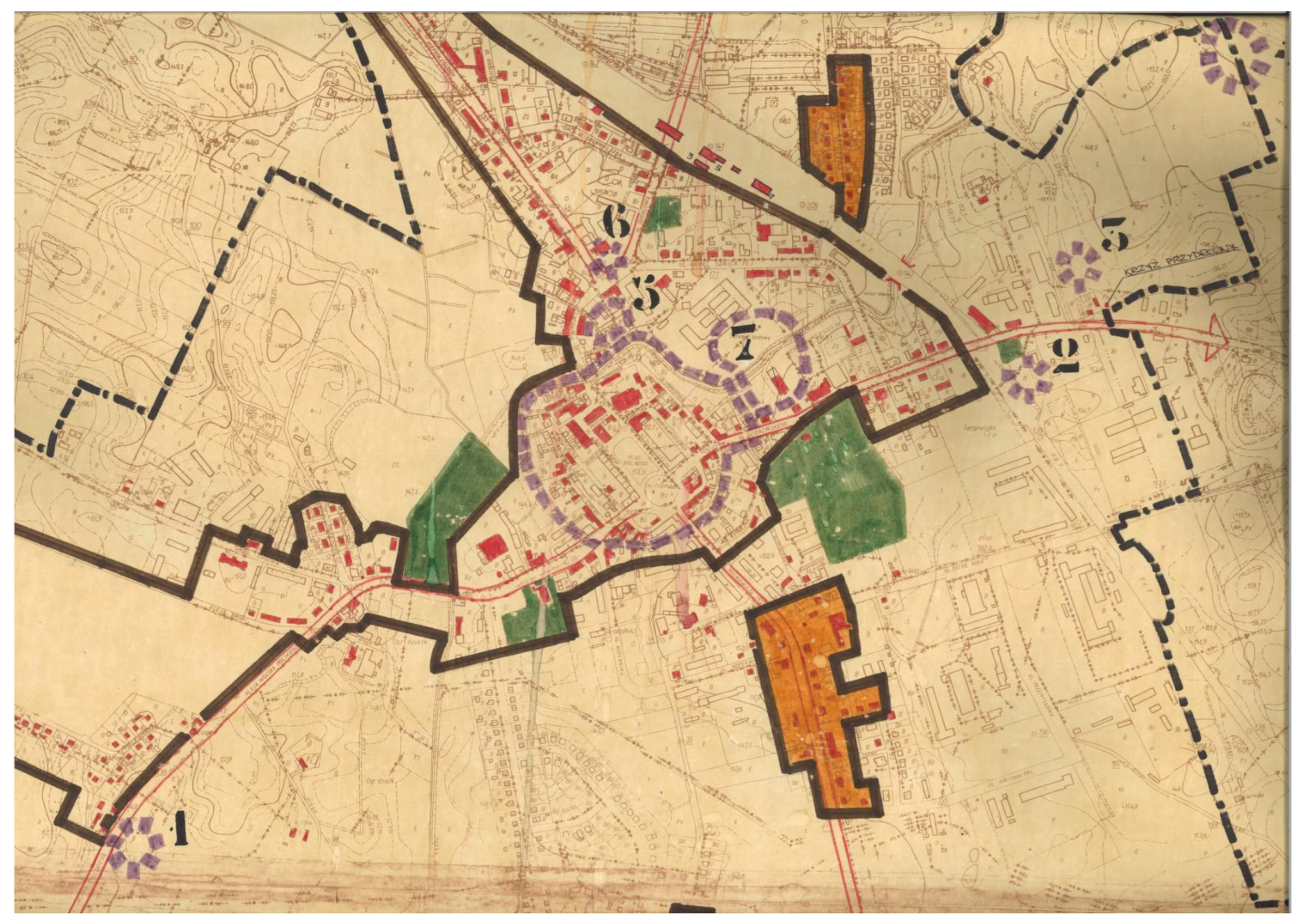
2.1. The Study Area

Four towns from northeastern Poland in the Warmian–Masurian Voivodeship were selected for the study (Figure 1). These are associated with the Association of Polish Cittaslow Towns: Bartoszyce, Biskupiec, Lidzbark Warmiński, and Olsztynek.
Among the analyzed towns, the most considerable number of inhabitants exists in Bartoszyce, while the smallest number exists in Olsztynek. The largest area of the square is 7756.7 m2 (Bartoszyce), while the smallest is 3311.7 m2 (Olsztynek) (Table 1).
Bartoszyce is a town with a diverse settlement network. The urban layout featured the predominance of buildings at the beginning of the 19th century and now features modern ones. Apart from forests in the city, a minor part of its total area is covered by urban green areas, such as parks and squares. Green areas and forests are also found on the slopes of the rivers flowing within the city limits [41]. Biskupiec is a component of a fragmented but relatively evenly distributed settlement network with multi-family and single-family buildings. The services areas are located chiefly in the central part of the town. High greenery in Biskupiec comprises dense trees in parks, squares, and lawns, belts of street trees, and cemetery greenery. The layout and development of all facilities are not orderly (small, isolated areas throughout the town [42]). Lidzbark Warmiński includes areas with various forms of use. In the city’s spatial structure, investment areas, including residential areas, occupy nearly one-third of the city’s area. The town’s development is dominated by multi-family housing, and a small area incorporates single-family housing. The areas of services and communication constitute approximately one-fifth of the town’s total area [42]. Green areas have the function of recreational regions in the form of natural greenery on the town’s borders, while green areas in the center are fragmented. Olsztynek is a town with a diversified spatial structure, mainly with small-scale buildings, including single-family houses and a few multi-family buildings. The service areas are dispersed. Green areas, including a park and small squares, primarily have a representative or recreational function. The most extensive form of greenery is the Ethnographic Park, but it is located outside the central part of the town [42].
All analyzed central squares have a similar origin, considering historical conditions. In some of them, such as in Biskupiec, after World War II, there were no buildings in the center of the square, which were demolished during the war. There were also changes in using and introducing infrastructure in their area in a similar period. The squares changed their function from commercial to utilitarian and representative.
Therefore, the main criteria for selecting the four main squares in four towns were as follows:
  • all squares were not centrally developed (without buildings before World War II or demolished after World War II);
  • in all cities in the 1970s, the square was used as a recreational and representative green area;
  • the squares were located on a rectangular plan;
  • revitalization projects were developed for all four central squares (provided for as part of individual urban revitalization programs after 2010 and co-financed by the Warmia and Mazury 2007–2013 Operational Program in the case of Biskupiec (project number WND-RPWM.04.02-28-041/09), Olsztynek (project no. WND-RPWM.04.02-28-046/09), and Lidzbark Warmiński (project no. WND-RPWM.04.02-28-054/09) [43] and by the Operational Program Warmia and Mazury 2014–2020 in the case of Bartoszyce).
Greenery in all analyzed squares in a layout that can be considered formal (with an initial idea, but without a design) was introduced in the 1970s. Earlier, in the 1960s–1970s, if greenery was introduced at all, it was done chaotically and accidentally. Various plant forms were often introduced, primarily perennials or small shrubs (most often roses). After the 1970s, shrubs, perennials, and annual species were successively planted in later years. However, the arrangement of these plantings remained unchanged; on the outside, the square was limited by shrubs or trees, while the center was filled with flower arrangements.

2.2. Research Stages and Methods

The research was divided into five stages (Figure 2). In the first, the individual revitalization programs and SLRP 2015 and SLRP 2019 were studied. In the second stage, states for selected central squares were analyzed. The third stage involved analyzing the introduced or liquidated greenery changes in squares. In the fourth stage, a comparative analysis of the occurrence of green forms in all towns was performed, while, in the fifth stage, guidelines and design proposals were developed, considering the results of the previous stages.
The conducted research covers two periods, the 1970s and the current state of development after the revitalization period. The revitalization of the analyzed squares occurred between 2010 and 2020. The areas of selected squares are part of the revitalization area in each town (Figure 3). In Bartoszyce, the total revitalized area covers 116.67 ha, while in Biskupiec, Lidzbark Warmiński, and Olsztynek, it covers 171 ha, 116.67 ha, and 248.35 ha, respectively. The issues related to broader research on public spaces and greenery of the entire revitalization area were presented in our previous article, while the presented research covers only central squares [44].
The revitalization process, starting from the idea of the signing of financing agreement project phases and the construction phase, lasted in each case about 2 years. The choice of such research periods was deliberate and dictated by changes in the “greening” of the squares. In the 1970s, various forms of greenery were introduced in the squares. The green areas had multiple functions, including passive recreation by the inhabitants. However, in the period of revitalization after 2010, disturbing changes in the structure of green areas and the phenomenon of its liquidation were observed in many small towns in northeastern Poland and other regions. The selection of four cities, out of 19 belonging to the Cittaslow network, for which SLRP is in force, considering an analysis of the situation in towns where the greenery was reduced to a minimum after revitalization (two cases) and in towns where greenery after revitalization is still present in central squares (two cases). Additionally, the selection was based on a similar layout (rectangular plan) and the approximate area of the square.

2.2.1. Stage I: Analysis of Revitalization Programs Related to Cittaslow Towns from Warmia and Mazury Voivodeship

In the first stage, individual revitalization programs of all towns were analyzed.
Revitalization in the analyzed documents “includes comprehensive activities undertaken in the city, primarily in old districts, neglected in terms of spatial, economic, aesthetic, infrastructural, transportation, and functional, threatened by social exclusion. Revitalization is an important instrument of the socioeconomic development of regions; it leads to the improvement of the quality of life of the local community. Improving the quality of life is understood as ensuring safety, improving the condition of the natural and cultural environment, restoring order in the urban space, increasing economic activity, and rebuilding social ties. The revitalization process must be coordinated and carried out by the principles of sustainable development, effectively integrating social, spatial, economic, cultural, investment, and environmental aspects within a specific goal” [45].
The programs analyzed are listed below.
  • Local Revitalization Program of Lidzbark Warmiński (Annex to Resolution No. LIII/393/10 of the City Council in Lidzbark Warmiński of 31 March 2010) [46];
  • Local Revitalization Program Biskupiec (Annex to Resolution No. XXXVIII/320/10 of 26 March 2010) [47];
  • Local Revitalization Program Olsztynek, Lidzbark Warmiński, as part of the Cittaslow City Network Revitalization Program (2015) [48,49];
  • Local Revitalization Program Bartoszyce for 2016–2022 (Resolution no XXIV/157/2016) [41].
Additionally, two collective revitalization programs were analyzed:
  • SLPR of Cittaslow Towns of Warmian-Masurian Voivodeship from 2015 [42];
  • SLPR of Cittaslow Towns of Warmian-Masurian Voivodeship from 2019 [45].
The main assumption of this task was to obtain information to what extent public space revitalization projects consider environmental and ecological aspects. Particular attention was paid to functions related to the design of green areas. At this stage, an analysis of the designs of central squares in selected four towns was also carried out in terms of the goals that guided the changes in revitalization. Such an analysis is justified due to the possibility of introducing possible guidelines to the assumptions of future editions of revitalization programs.

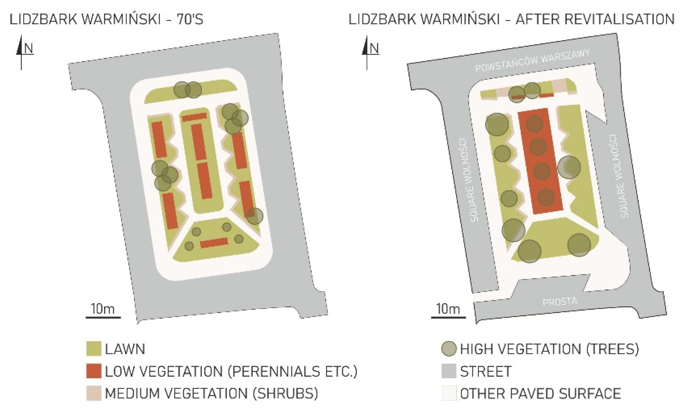
2.2.2. Stage II: Analysis of States Regarding the Planning of Selected Central Squares in Two Periods

This stage consisted of determining the layout and style of the developed square and then referring to the changes after the revitalization period. The method for planning squares in the 1970s was analyzed on the basis of publicly available plans and photographic material from that period [50,51].
Additionally, the current state of development was analyzed on the basis of current cartographic materials and field visits from August 2021 to November 2021. The analysis of general functions of the square was carried out, as well as in the context of accessibility, existing infrastructure, surface, elements of street furniture, and ultimately greenery. The area allocated to individual functions and square elements was calculated for the two research periods. The area was calculated following generally accepted principles. The results obtained in the measurements were converted from the scale in which the figures were made to the actual dimensions.

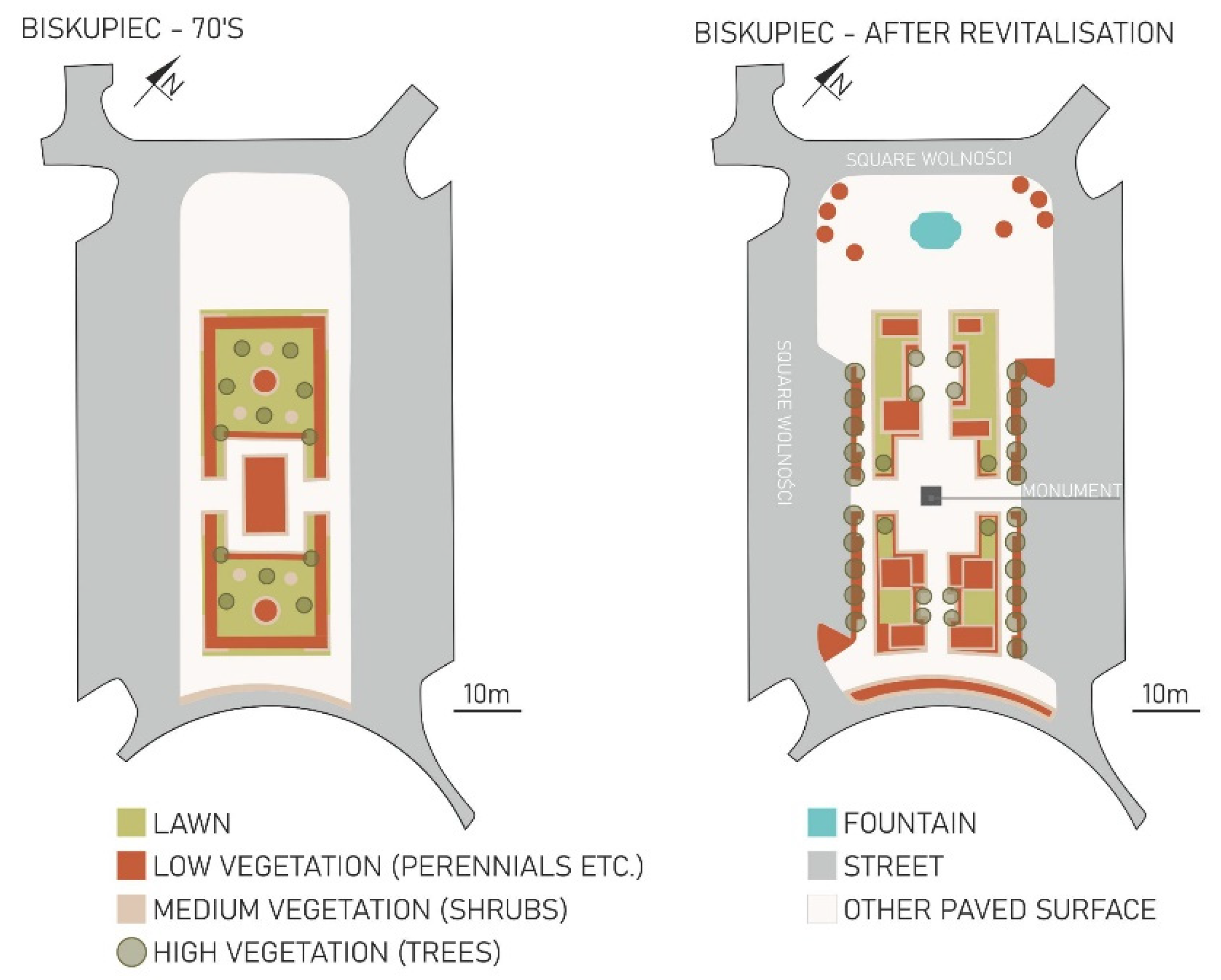
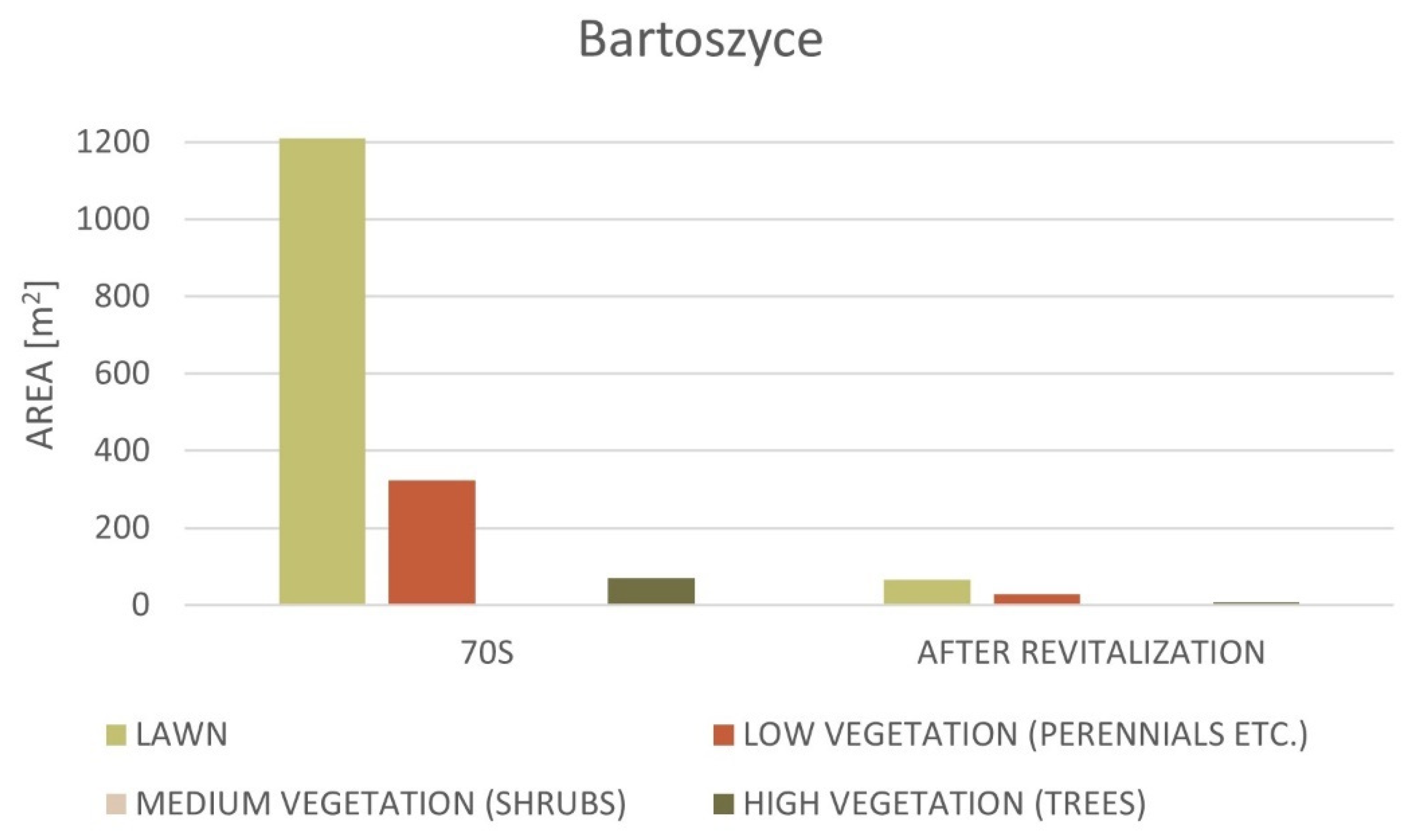
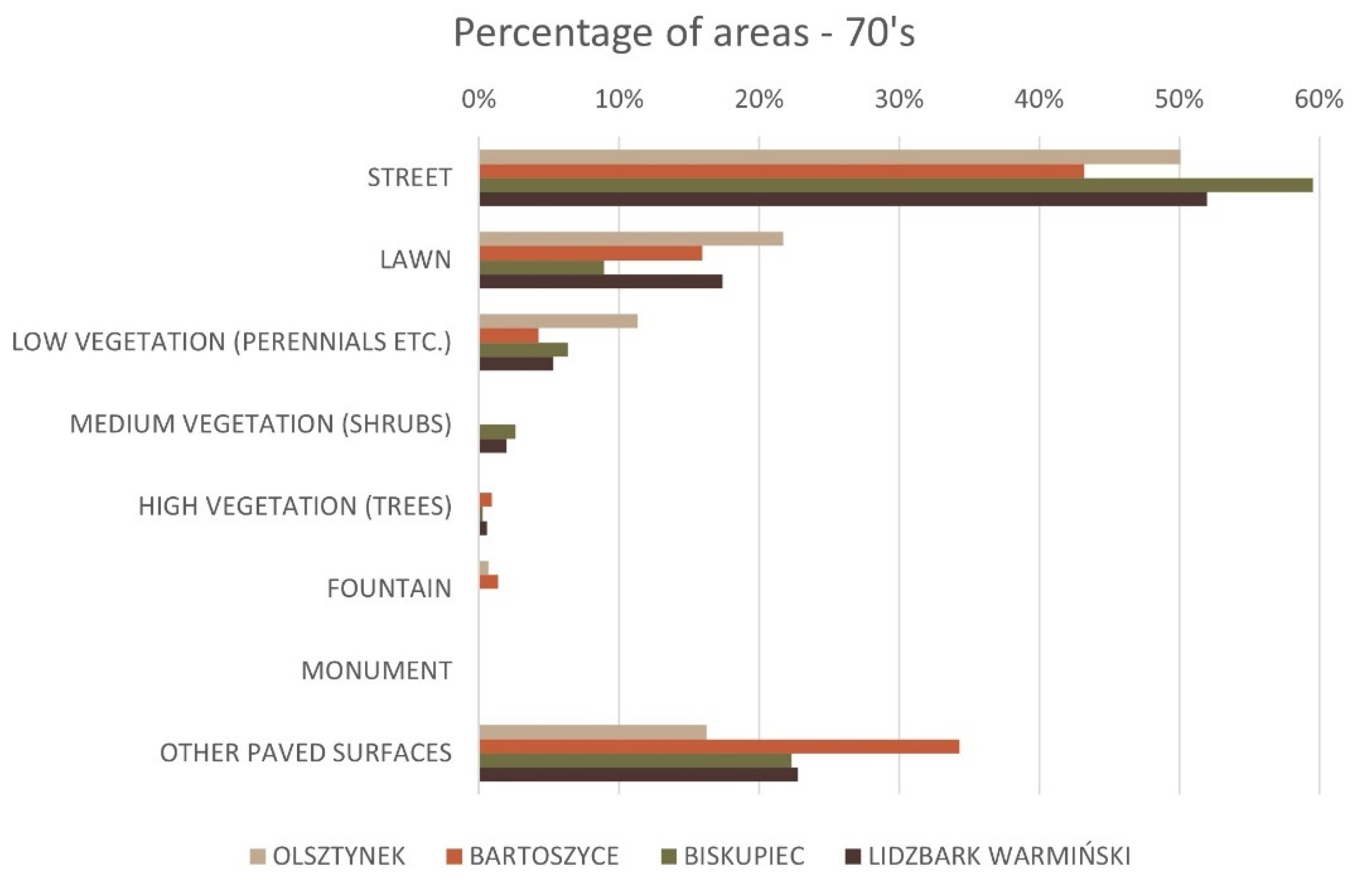
2.2.3. Stage III: Analysis of Changes Related to the Introduced or Liquidated Greenery in Squares in Selected Towns

The types of greenery, the area intended for vegetation, and greenery functions were analyzed, considering the research periods adopted in the assumptions. Additionally, an analysis of changes in green forms and changes in species diversity was performed. During the study of the existing forms of greenery, four main types were distinguished:
  • high greenery (trees);
  • medium greenery (shrubs);
  • low greenery (perennials, biennials, annuals, ornamental grasses);
  • lawns.
After determining the forms of greenery occurring in the squares, the proportion of individual groups in terms of area in the first (before revitalization) and second (after revitalization) period was determined. Then, the degree of changes in green cover was determined, considering the analyzed forms of green and the general greenery. At this stage, in addition to the forms of greenery mentioned above, the following aspects were calculated:
  • the analyzed area of the square;
  • the area of streets/roadways/parking lots;
  • the area with the fountain (in the squares where it occurs);
  • the area with the monument (in the squares where it occurs);
  • other hardened surfaces.
After revitalization, calculations for the state consisted of determining the square’s entire area and then individual elements on the basis of information from cartographic materials and data available on the geoportal and local websites. The measurements from the 1970s were determined on the basis of cartographic materials and photographs from publicly available collections [50,51] or obtained from the archives of towns offices. An example of the archival source material for Biskupiec is presented below (Figure 4 and Figure 5).
The photographic material (Figure 6) was beneficial in the analysis due to the possibility of detailing the forms of greenery. Thanks to the aerial photographs of the squares, the perspective view of the entire square, or the characteristic points of the square, it was possible to adjust some of the existing forms or spaces to their former condition.
The information collected in this way was prepared in a graphic form illustrating the state of development in both analyzed periods. The maps were prepared and scaled, and then the areas were determined on their basis. The areas of squares and selected elements of squares were calculated in m2.

2.2.4. Stage IV: Comparative Analysis of Green Forms in all Towns

To determine the degree of green coverage of squares in all analyzed towns, a comparative statement was made at this stage concerning individual forms of greenery and the entirety of vegetation. This allowed determination in which city the changes are noticeable in a significant, medium, and low way. To conduct a comparative analysis, the previously prepared maps showing the condition from the 1970s and after revitalization were used. This comparison included quantitative data collected in Stage IV. To compare the data on the areas covered by the analyzed forms, tabular summaries were created, and then, on their basis, charts were prepared to show the state of the two studied periods.

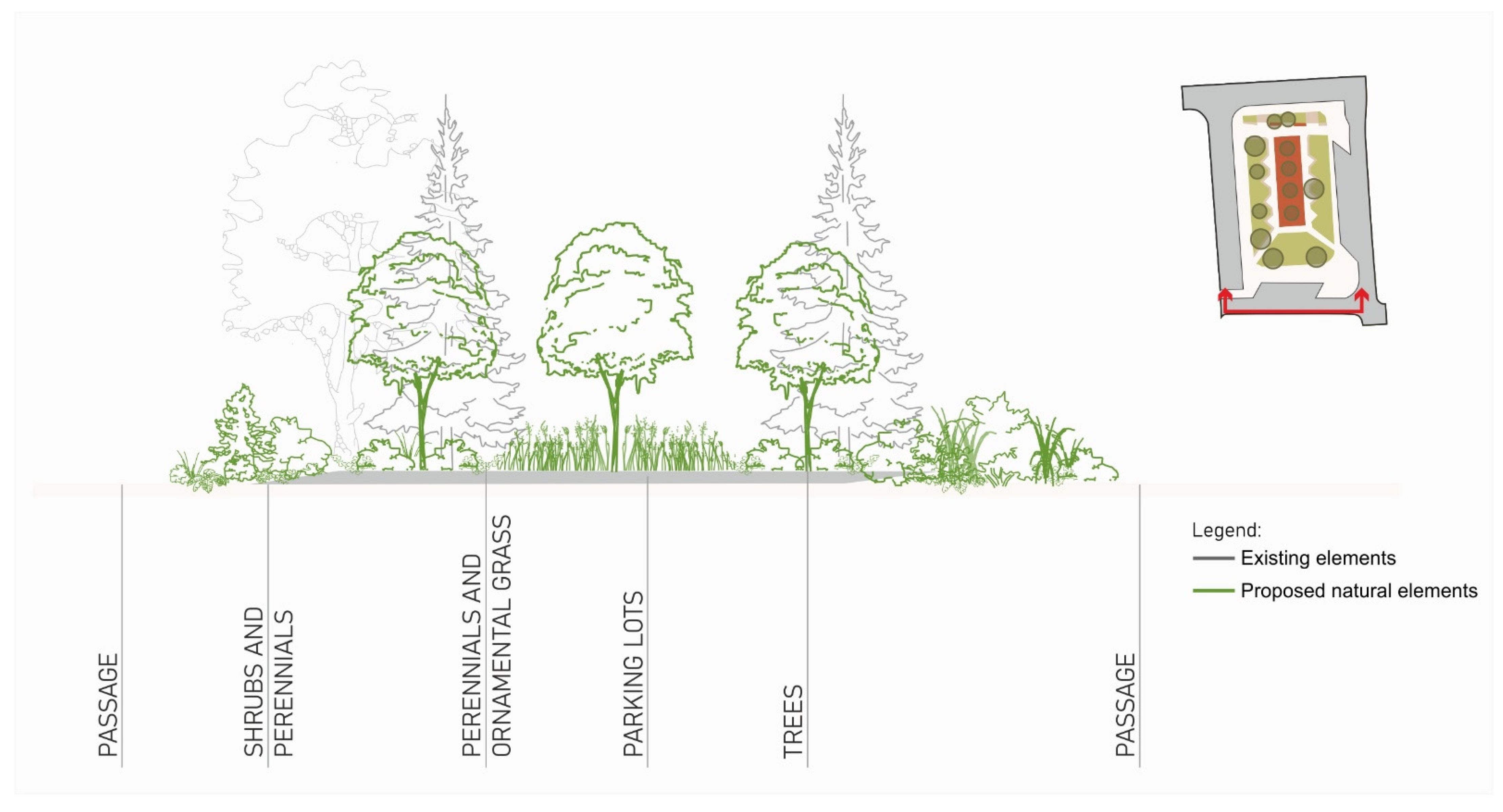
2.2.5. Stage V: Guidelines for the Introduction of Various Forms of Greenery in the Analyzed Cities and Design Proposals

On the basis of the results from the previous stages, general guidelines for the future revitalization of city squares are proposed. These guidelines may help to redesign squares in the case of developing a revitalization program and projects in small towns in the future. They can also constitute the basis for changes in the development of existing squares.
A method commonly used in planning, architecture, or landscape architecture is based on design research [53]. Proposed changes for the analyzed squares are presented. At this stage, reference was made to the existing elements in the analyzed squares, and the introduction of new forms was proposed. A fragment of the squares for which cross-sections were made was selected for each analyzed square. On each cross-section, the existing and proposed elements are indicated. In Biskupiec, a cross-section for the northwest was made with a proposal of a fragment of plant composition. It was proposed to introduce row planting of deciduous trees, adding perennials, ornamental grasses and shrubs, and trees inside the plant composition. In Lidzbark Warmiński, the focus was on the southern part of the square where parking spaces are located. The proposed changes included the introduction of perennials, ornamental grasses, and shrubs. Additionally, trees were added in the central part of the indicated section. Parallel to the western border of the square in Olsztynek, a place was indicated for introducing low and high greenery in the form of raised flower beds (in the form of flowerpots). However, for Bartoszyce, in the central part of the square, where the fountain is located, it was proposed to introduce high greenery and low greenery in the form of ornamental grasses.

3. Results

3.1. Diagnosis of the Main Assumption of Public Space Planning as a Part of the Revitalization in Cittaslow Towns (Based on Individual Revitalization Programs and SLRP 2015, 2019)

The main goal of this stage was to diagnose problems and the assumptions of the prepared revitalization projects of public spaces. After initial verification, the most critical issues were selected as follows:
  • the goals of the revitalization of public areas mainly consider changes taking into account social aspects, e.g., making the areas more attractive for use by residents or increasing their value for potential tourists;
  • in the description of projects in SLRP, the changes relate mainly to the improvement of technical infrastructure, pavements, and land equipment;
  • green areas are treated marginally, and if information about green area projects appears, it mainly concerns the purpose of these areas;
  • projects of the green area most often refer only to increasing the aesthetic function or improving the image of the space;
  • almost all descriptions in SLRP about public space projects, especially green areas, lack information about the environmental and ecological, environmental, and health-promoting functions.
As can be seen from the above, the effects of revitalization are measured in the context of socioeconomic benefits. Meanwhile, by definition, revitalization should cover social and economic goals, as well as environmental, pro-ecological, and indirectly pro-health goals [54,55,56,57,58].
At this stage, an analysis of the assumptions of the central square projects in four towns selected for the study was also carried out. The squares of the analyzed Cittaslow towns after revitalization can be divided into the following:
  • in which the old greenery was removed, but new forms of greenery were introduced as a substitute, for example, Plac Wolności Square in Biskupiec and Plac Wolności Square in Lidzbark Warmiński;
  • in which old forms of greenery were removed and greenery was introduced in the form of flower beds and pots with plants, for example, the square by the town hall in Olsztynek;
  • with complete elimination of greenery and introduction of hardened surfaces, for example, Plac Konstytucji 3 Maja in Bartoszyce.

3.2. Results of the Analysis of Changes in the Direction of Development of Central Squares

In the case of the squares in Biskupiec and Lidzbark Warmiński, the changes in the development of green areas were assessed as minor from the point of view of their function. After considering the guidelines and design proposals, they can be based on the principles of “eco”. This means that the function of a green area with diverse plant forms adopted in the design concept should be maintained. At Plac Wolności Square in Biskupiec (Figure 7), the green layout did not change significantly after the revitalization project. To a large extent, this space assumed the function of a green area, which is also a place for residents. The layout of the square and the existing greenery is geometric, highlighted by a row of trees on both sides of the leading site with linearly delineated borders of the medium and low plantings. The surface of the square was replaced with slabs and pavement. Lighting was planned, and a fountain was introduced on the axis of the site toward the north. It should be noted that the design of the surface, the fountain, and the lighting was a separate project unrelated to the design of the vegetation.
The Plac Wolności Square in Lidzbark Warmiński has a similar form of the green area (Figure 7). The continuation of the style from the period before the revitalization is visible, and the layout of the entire complex and the greenery introduced is geometric.
The square in Olsztynek (Figure 7) next to the town hall was transformed according to the guidelines of the conservator of monuments. The guidelines required reference to the pre-war agreement in the draft. Therefore, in the first proposal to revitalize the square, the greenery was not designated, instead opting for a paving surface and elements of equipment, including a fountain, lighting, and street furniture. In the second version of the project, corrections were introduced and, thus, the introduction of greenery was proposed. Due to earlier changes resulting from the first version of the project, it was possible only in points, including trees in the form of stems and the entire site and greenery in pots.
Most changes were made in the case of Plac Konstytucji 3 Maja in Bartoszyce. On the square with a rectangular plan, the greenery in rows of trees formed the border of the green area, and the remaining vegetation in the form of shrubs and low vegetation was eliminated. The lawns were also removed. Alternatively, a paved surface made of slabs and cobblestones was introduced. There was also a fountain on the surface with point-based streams and lighting. The geometric layout of the square on the rectangular plan remains unchanged, but a change in subdivision is visible. After revitalization, the square is structurally one whole, without divisions into a green area (a significant share of greenery) and an open part, visible in earlier periods.
The changes related to the removal of greenery in the squares, visible in the example of two towns (Bartoszyce, Olsztynek), result from the approval of projects by officials, as well as indirectly from the use of the guidelines set by the conservator regarding the restoration of the squares to the state of development from before World War II. Therefore, there was no proposal to leave the green area in line with the function of the square after World War II. The project in Bartoszyce assumed the liquidation of greenery. Therefore, after its implementation, it was met with critical comments from the residents and negative opinions from the country’s spatial planners and landscape architects. The project in Olsztynek assumed the maintenance of greenery to a minimum extent, but the city authorities and officials decided to correct the project by introducing more greenery. However, this version was not approved by the conservator, who upheld the guidelines that did not consider protecting the greenery from the 1970s or introducing new forms of greenery to the square after revitalization. In the squares in Lidzbark Wamrmiński and Biskupiec, the form of a green area was preserved, assuming the possibility of introducing new forms of greenery as compensation for possible felling of forms requiring removal due to the aging of the plant material. For example, new forms were also submitted, such as linden row plantings in Biskupiec.

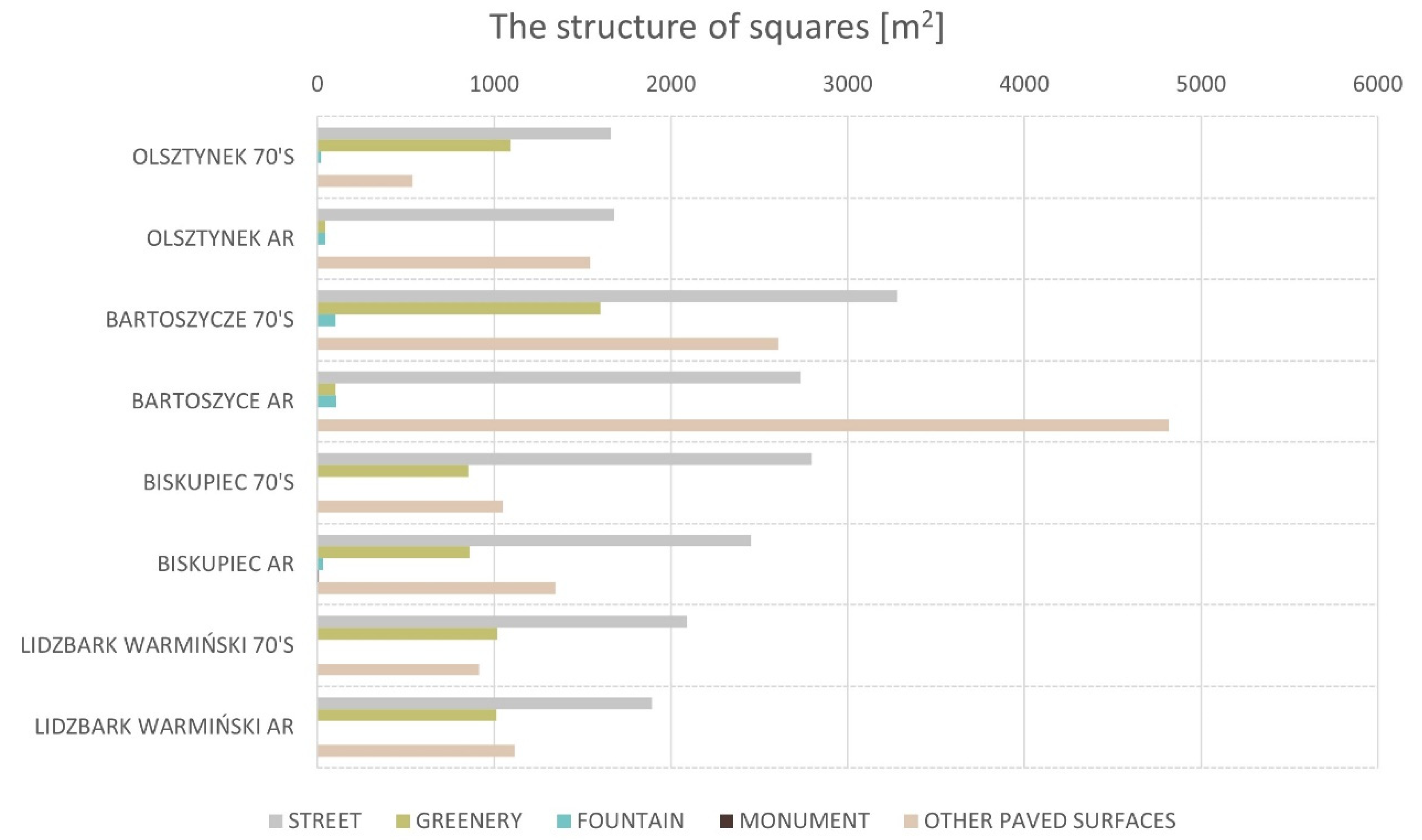
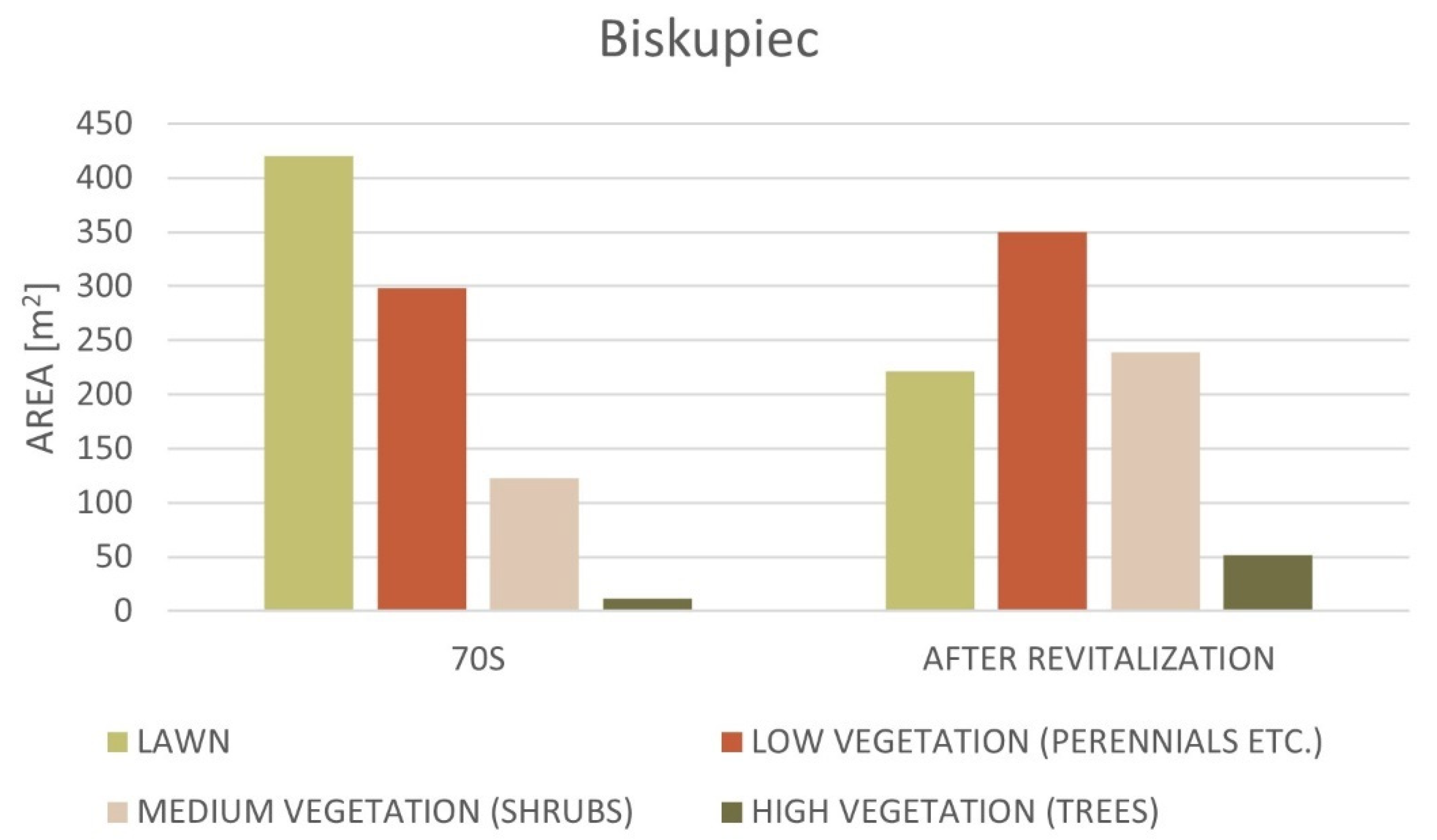
3.3. The Results of the Analysis of Changes Concerning the Introduced or Liquidated Greenery in Squares in Selected Cities

The analyses show that, in Biskupiec, despite the replacement of vegetation and planning a new one in its place, favorable changes can be seen in terms of introducing, in particular, medium and low forms, as well as trees (Figure 8).
Comparing the changes in the forms of greenery in Plac Wolności in Biskupiec (Figure 9), the lawn area was reduced by almost one-half. However, the area of all forms of greenery increased, including trees, shrubs, and low vegetation. Moreover, among all forms, a tremendous change in terms of the square’s surface coverage is noticeable in the case of medium forms (shrubs), low forms (perennials), and tall forms (trees).
In Lidzbark Warmiński, there were not so many changes in the structure of green forms and the area covered by them (Figure 10). It can be assumed that the diversity of forms was maintained at a similar level, slightly changing their arrangement (e.g., low vegetation or trees).
The most visible change was the increase in the area covered by low forms (perennials) and, to a lesser extent, by medium forms (shrubs). The surface of tall forms (trees) did not change, despite the change in the layout (Figure 11).
In Olsztynek, a significant change in the area intended for greenery can be noted. In place of the green area, the square was replaced mostly with cobblestones, separated by stone stripes along the square and in the center. The new vegetation appears only in filled pots (low plantings, few shrubs) and spot-planted trees on the surface (after redesigning in the second version of the project). There are also rectangular-shaped fountains on opposite sides of the square (Figure 12).
The biggest difference concerned reducing the area of lawns (low forms) and shrubs (medium forms). Interestingly, the area intended for planting trees increased, yet the area for tall forms is insufficient (Figure 13).
The analysis of changes in the greenery structure in the square in Bartoszyce shows that the loss of greenery after revitalization was enormous (Figure 14). The square is mainly paved and made of slabs. A fountain element was introduced (slots in the surface).
The analysis also shows that the area of all forms of greenery (high, medium, and low) decreased significantly. The most visible change concerned the surface of the low and high forms. Trees were introduced, but they are of minimal importance to the whole square. Medium forms (shrubs) are also missing. However, in the period before the revitalization, this form was not present in the square (Figure 15).

3.4. Results of a Comparative Analysis of Green Cover in all Selected Cities

According to the comparative analysis, in the first research period (the 1970s), the lawn in all four towns had the largest share in terms of the area of greenery (from approximately 9% in Biskupiec to almost 22% in Olsztynek). A slightly smaller area was covered with low forms (from about 4% in Bartoszyce to 11% in Olsztynek). Medium forms (shrubs) were found only in Biskupiec (approximately 2.6% and Lidzbark Wamiński approximately 2%), while tall forms were found in Bartoszyce (approximately 1%), Lidzbark Warmiński (approximately 0.5%), and Biskupiec (approximately 0.3%) (Figure 16).
In the second research period (after revitalization), the largest lawn area was planned in Lidzbark Warmiński (approximately 16%), then Biskupiec (approximately 4.7%), and the smallest in Bartoszyce (approximately 0.9%). There is no lawn in the new arrangement of the square in Olsztynek. Comparing the areas of low forms, the most prominent location is Biskupiec (approximately 7.5%), followed by Lidzbark Warmiński (approximately 6.40%) and then Olsztynek (approximately 0.8%), with the least in Bartoszyce (0.40%). Medium-sized (shrubs) forms are most prominent in Biskupiec (about 5.1%) and Lidzbark Warmiński (about 2.3%). Medium forms after revitalization did not occur in the squares in Bartoszyce and Olsztynek. The largest tree area is in the square in Biskupiec (about 1.1%), followed by Lidzbark (about 0.6%) and then Olsztynek (about 0.53%), while, in Bartoszyce, they occupy an area of about 0.09% (Figure 17).
Comparing the two periods, the research results indicate that tremendous unfavorable changes in the “disappearance” of greenery in general and individual forms of greenery (apart from medium forms) are visible in the square in Bartoszyce. This is alarming, especially regarding the loss of tall forms (old trees of significant size) and low forms. The second city that has lost or decreased its green area is Olsztynek. The only advantage is that tall forms (trees) were introduced here. In two towns, Lidzbark Warmiński and Biskupiec, a positive increase or stabilization of the surface of the tall, medium, and low forms can be noted. However, in the case of these two cities, the lawn area slightly decreased. Considering the percentage of greenery in the squares, the largest area dedicated to greenery is in Biskupiec.

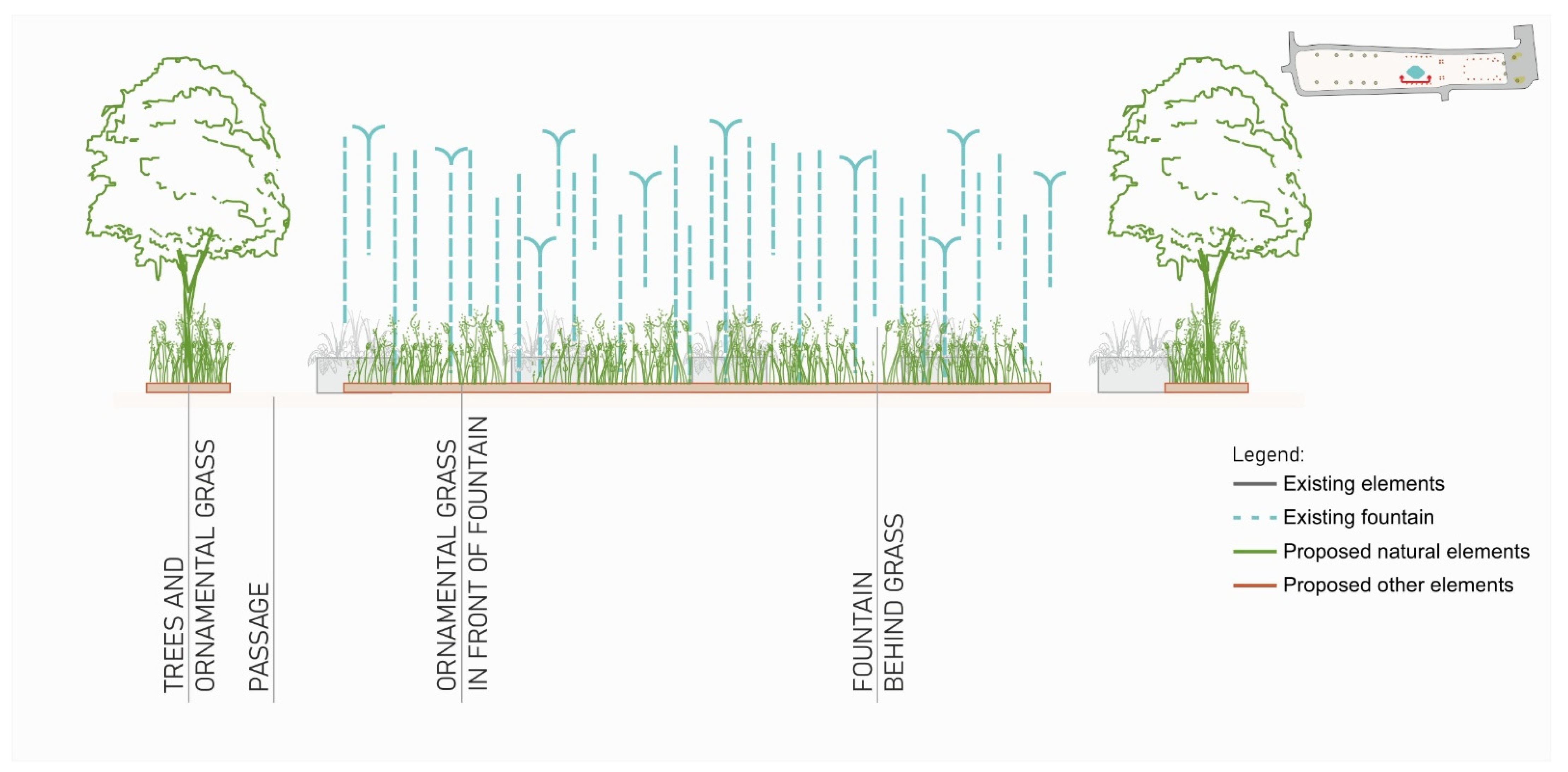
3.5. Guidelines for Introducing Various Forms of Greenery in the Analyzed Cities: Design Proposals

According to the above research, general design guidelines were devised to be transferred to town planning for revitalization. The general guidelines include the following:
  • increasing the surface of tall and medium forms due to their significant biological and ecological role;
  • increasing the surface of low forms (perennials) due to their impact on biodiversity (greater species diversity);
  • introduction of lawns as a supplement to tall and medium-sized forms;
  • introduction of vegetation through its appropriate planning, paying particular attention to the use of various forms.
Additionally, proposals for changes in the analyzed squares were prepared. The proposed changes are related to the ratio of increasing greenery to the cost of hardened surfaces and to the principle of introducing various forms. In Biskupiec, where the green area after revitalization is maintained at a high level, slight changes in the plant cover are proposed. It is recommended to introduce low (perennials, etc.) and medium (shrubs) vegetation in the areas currently covered with lawns. Additionally, it is worth considering the introduction of short trees (e.g., Acer campestre ‘Nanum’ or Prunus serrulata ‘Kanzan’) in the form of solitary trees within the central flowerbed (Figure 18). Additionally, linear planting of deciduous trees should be introduced to provide the inhabitants with other shaded areas. When submitting this type of planting, it should be noted that the transition between the developed spaces should be sufficient for the users of the space.
In the square in Lidzbark Warmiński, it is primarily proposed to change the space near the car parks. It is definitely worth locating trees (e.g., Sorbus intermedia or Crataegus pedicellata) next to parking spaces and rest areas. Such a procedure will effectively protect people from excessive sun exposure, especially in the summer. Flowering perennials and ornamental grasses can be elements enriching the space between the proposed trees. The proposed changes also include planting groups of shrubs and perennials, which are located on both sides of the parking lots (Figure 19).
When proposing changes in Olsztynek, flowerpots can be used, placed on the existing surface. Only such a form replacing typical plantings in the ground is possible (Figure 20). Solutions of this type will fit into the current state of development, in which there are already several such forms of flower beds. In addition to the most popular solutions, i.e., pots filled with perennials or seasonal plants, vases can be introduced. These vases can be filled with trees whose root system is adequate to the conditions in which the plants are to be planted (e.g., Acer campestre ‘Nanum’, Amelanchier alnifolia ‘Obelisk’ PBR, or Betula pendula ‘Youngii’). When placing these elements within the square, special attention should be paid to maintaining appropriate distances that allow free movement of users on the square.
On the basis of the state of development of the town square in Bartoszyce, changes are proposed in the vicinity of the fountain (Figure 21). The fountain in Bartoszyce is in the form of nozzles on its surface. Therefore, flower beds can be introduced around the fountain. It is crucial to keep an appropriate distance to ensure comfortable passage and safe use of the fountain. The proposed flower beds can be divided into two types. Flowerbeds located parallel to the long side of the space intended for the fountain can be planted with ornamental grasses. Flowerbeds parallel to the shorter side can be additionally enriched with trees. Thanks to the use of ornamental grasses in the central part of the square with an accompanying water element, one can expect the feeling of a party from the hustle and bustle of the city. Additionally, the trees can provide shade, which will provide additional protection against high temperatures, especially in the summer.

4. Discussion

This topic has not been discussed more widely in the studies of small towns, especially in the countries of central and eastern Europe. Therefore, the presented issues and the research results introduce new content. The analysis carried out in Cittaslow cities indicates the disturbing phenomenon of reducing the role of greenery in the design of public spaces. So far, this phenomenon has concerned spaces in large Polish cities, where the effect of, for example, changes in functions, presenting economic benefits over the quality of life of residents and the quality of the environment, are visible. Our research also indicates a loss of environmental values through the loss of the diversity of greenery in small towns (most visible in the examples from Bartoszyce and Olsztynek). Although, in numerous assumptions of spatial policies and revitalization programs, environmental issues are emphasized as one of the most important and are treated on a par with economic and social problems [59,60,61] in the revitalization projects being implemented, greenery is treated marginally. Greenery only complements infrastructural projects [62]. The marginalization of greenery in public spaces often results from a lack of cooperation among planners, architects, monuments conservators, and landscape architects [63,64]. Some researchers indicated economic [65], social [66,67], and spatial development as the priority direction of revitalization in Cittaslow cities regarding the historical aspect [68]. Other authors referred to the need to maintain the historical value of areas located in the centers of small towns, e.g., in the city of Węgrów [69]. The research on greenery carried out by Gawryluk in the context of the historical space of large and medium-sized cities, including Białystok, Augustów, Choroszcz, Knyszyn, Ostrów Mazowiecka, and Suwałki, indicated a significant role of greenery in squares, especially when planned in the period after World War II [70]. The assumptions presented by the author can be related to the results of our research in small Cittaslow cities. Kozak and Kimic [71] also reached similar conclusions when examining 39 small towns of the Lublin region, including Józefów, Kock, Kurów, and Wąwolnica, as well as Dymek and Jóźwik [72].
Therefore, in an era of environmental and climate changes, it is necessary to change the way of designing public spaces in shopping centers [73,74,75]. The research on pro-ecological investments in the public, service, and housing sectors conducted in 2021 emphasized this necessity or even requirement to introduce ecological trends [76] into the urban space [77]. The city center, including city squares, should not only be “pretty” or “aesthetic” but should consider environmental changes. Landscape architects should particularly represent this perspective.
Another problem is the lack of guidelines for square design considering historical (conservator’s policies) and social and environmental issues. In particular, there are no guidelines for planning squares from the perspective of landscape architecture. Additionally, the revitalization of squares in small towns of Cittaslow in the Warmia and Mazury region, according to the idea of returning to the state from before the Second World War in an era of environmental and climate change, does not seem to be the best solution. When redefining the design assumptions in the revitalization process, it is also necessary to consider the complete transformation of the functions of central squares from commercial (before World War II) to recreational and service (after World War II). In this context and view of the current environmental requirements, lawns established in the 1970s seem to be a better model in terms of the direction of “green” activities. In the case of two analyzed cities (Biskupiec and Lidzbark Warmiński), the research results show that maintaining the function of the green area from the perspective of the current needs and the need to protect the existing greenery is appropriate. It is true that, in the perspective of the subsequent years of using the squares in these cities, it is further recommended to increase the area of high- and medium-sized forms. Nevertheless, the direction of greening undertaken in the revitalization process is favorable from the environmental perspective. Given the above, we suggest that future solutions for the revitalization of city centers, mainly green areas in central squares in other small towns, should be based primarily on extended guidelines for revitalization projects and not on general, often misinterpreted assumptions. This applies particularly to the permissible functional and spatial solutions and the greening of squares in places where such lawns were previously located.
In the proposed solutions for each square, we assigned a significant role to the need to introduce greenery, even in places where it seems that there is no such possibility (example of squares in Bartoszyce and Olsztynek. These recommendations may be helpful for changes to similar squares in other cities, where too much paved surface has been introduced, and complete revitalization is impossible. Such vegetation can be planned in special boxes or pots, and their arrangement can be adapted to the specifics of a given square. Notably, the guidelines and such proposals for introducing greenery make it possible to increase the biologically active area. In the case of squares where the green area after revitalization is similar to the area before revitalization, but mainly low forms (perennials) have been introduced, it is worth considering increasing the area intended for higher and medium forms. The aim of such a solution is also to increase the biologically active area and the possibility of continuing the function of greenery in the central square (similar to the proposals in Biskupiec and Lidzbark Warmiński). In other cities, in squares with a central fountain (such as the example of Bartoszyce), it is proposed to use the water cycle and introduce low forms nearby, e.g., ornamental grass. Another solution, also based on the example of the proposal for Bartoszyce, is the possibility of introducing low forms creating a compact structure under trees (for instance, ornamental grass).

5. Conclusions

The research results indicate a different approach to the issue of planning public spaces in small towns, especially those belonging to the Cittaslow network, considering environmental and ecological aspects. The broadly understood revitalization does not always consider the need or necessity of a new approach to universal and pro-ecological planning. This applies particularly to increasing the role of greenery in dense urban development, e.g., within city squares and, if possible, increasing the biologically active area. Due to the lack of legal provisions and, on the other hand, the lack of guidelines on how to design the square to make it “green”, many cities seemingly applied only the historical context (often ineffectively), without considering the subsequent functional and spatial layers and complete change functions in subsequent development periods. Thus, the method and criteria of planning should be redefined, considering current needs. Therefore, developing guidelines for future projects to restore squares in small towns seems essential. It should also be noted that the form and style in the revitalization proposals for the analyzed central squares and those remaining in Cittaslow towns should correspond to the previously developed guidelines included in revitalization programs, and the designs should be individualized.

Author Contributions

Conceptualization, A.J.; methodology, A.J. and E.P.; software, A.J. and E.P.; validation, A.J., E.P. and B.P.-W.; formal analysis, A.J. and E.P.; investigation, A.J.; resources, A.J. and E.P.; writing—original draft preparation, A.J. and E.P.; writing—review and editing, A.J., E.P. and B.P.-W.; visualization, E.P.; supervision, A.J.; project administration, A.J. All authors have read and agreed to the published version of the manuscript.

Funding

This research received no external funding.

Institutional Review Board Statement

Not applicable.

Informed Consent Statement

Not applicable.

Data Availability Statement

Not applicable.

Acknowledgments

The authors would like to thank the project APVV SK-PL-18-0022 633 LIVA—The concept of livability in the context of small towns funded by the NAWA—Polish National Agency for Academic Exchange and SRDA—Slovak Research and Development Agency for enabling the work required for the article. The authors would like to thank the project PROM—International scholarship exchange of PhD candidates and academic staff funded by the NAWA—Polish National Agency for Academic Exchange.

Conflicts of Interest

The authors declare no conflict of interest.

References

  1. Gulgun, B.; Guney, M.A.; Aktas, E.; Yazici, K. Role Of The Landscape Architecture In Interdisciplinary Planning Of Sustainable Cities. J. Environ. Prot. Ecol. 2014, 15, 1877–1880. [Google Scholar]
  2. Li, F.; Wang, R.S.; Paulussen, J.; Liu, X.S. Comprehensive concept planning of urban greening based on ecological principles: A case study in Beijing, China. Landsc. Urban Plan. 2005, 72, 325–336. [Google Scholar] [CrossRef]
  3. Russo, A.; Cirella, G.T. Modern Compact Cities: How Much Greenery Do We Need? Int. J. Environ. Res. Public Health 2018, 15, 2180. [Google Scholar] [CrossRef] [PubMed] [Green Version]
  4. Nassauer, J.I. Landscape as medium and method for synthesis in urban ecological design. Landsc. Urban Plan. 2012, 106, 221–229. [Google Scholar] [CrossRef] [Green Version]
  5. Andersson, E. Functional landscapes in cities: A systems approach. Landsc. Ecol. Eng. 2018, 14, 193–199. [Google Scholar] [CrossRef]
  6. Beatley, T. Handbook of Biophilic City Planning and Design, 1st ed.; Island Press: Washington, DC, USA, 2016. [Google Scholar]
  7. Lemes de Oliveira, F. Green Wedge Urbanism, 1st ed.; Bloomsbury Publishing: London, UK, 2017. [Google Scholar]
  8. Watchman, M.; DeKay, M.; Demers, C.M.H.; Potvin, A. Design vocabulary and schemas for biophilic experiences in cold climate schools. Archit. Sci. Rev. 2021, 1–19. [Google Scholar] [CrossRef]
  9. Breed, C.A.; Cilliers, S.S.; Fisher, R.C. Role of Landscape Designers in Promoting a Balanced Approach to Green Infrastructure. J. Urban Plan. Dev. 2015, 141, A5014003. [Google Scholar] [CrossRef] [Green Version]
  10. Caprotti, F.; Springer, C.; Harmer, N. “Eco” For Whom? Envisioning Eco-urbanism in the Sino-Singapore Tianjin Eco-city, China. Int. J. Urban Reg. Res. 2015, 39, 495–517. [Google Scholar] [CrossRef]
  11. Cilliers, S.S.; Breed, C.A.; Cilliers, E.J.; Lategan, L.G. Urban Ecological Planning and Design in the Global South. In Urban Ecology in the Global South. Cities and Nature; Springer: Cham, Switzerland, 2021; pp. 365–401. [Google Scholar]
  12. Dymitrow, M. The effigy of urbanity or a rural parody? A visual approach to small-town public space. J. Cult. Geogr. 2014, 31, 1–31. [Google Scholar] [CrossRef]
  13. Carmona, M. Contemporary Public Space: Critique and Classification, Part One: Critique. J. Urban Des. 2010, 15, 123–148. [Google Scholar] [CrossRef]
  14. Sarga, A. The Ecological Pedestrian Bridges. Teka Kom. Urban. I Archit. 2015, 43, 211–219. [Google Scholar]
  15. Balsas, C.J.L. City Centre Revitalization in Portugal: A Study of Lisbon and Porto. J. Urban Des. 2007, 12, 231–259. [Google Scholar] [CrossRef]
  16. Ciepiela, A. Reinstanation the Significance of City Main Public Space -Revitalization of the Main Square in Polaniec. In Proceedings of the 3rd World Multidisciplinary Civil Engineering, Architecture, Urban Planning Symposium (WMCAUS), Prague, Czech Republic, 18–22 June 2018. [Google Scholar]
  17. Wang, Y.C.; Yamaguchi, K.; Kawasaki, M. Urban revitalization in highly localized squares: A case study of the Historic Centre of Macao. Urban Des. Int. 2018, 23, 34–53. [Google Scholar] [CrossRef]
  18. Perano, M.; Abbate, T.; La Rocca, E.T.; Casali, G.L. Cittaslow & fast-growing SMEs: Evidence from Europe. Land Use Policy 2019, 82, 195–203. [Google Scholar] [CrossRef]
  19. Mazur-Belzyt, K. ‘Slow’ Revitalization on Regional Scale, the Example of an Integrated Investment Project. In Proceedings of the World Multidisciplinary Civil Engineering-Architecture-Urban Planning Symposium (WMCAUS), Prague, Czech Republic, 12–16 June 2017. [Google Scholar]
  20. Farelnik, E.; Stanowicka, A.; Wierzbicka, W. The effects of membership in the Polish National Cittaslow Network. Equilib. Q. J. Econ. Econ. Policy 2021, 16, 139–167. [Google Scholar] [CrossRef]
  21. Farelnik, E.; Stanowicka, A. Smart City, Slow City and Smart Slow City as Development Models of Modern Cities. Olszt. Econ. J. 2016, 11, 359–370. [Google Scholar] [CrossRef] [Green Version]
  22. Vaznoniene, G.; Vaznonis, B. Strengthening Youth Wellbeing Through Green Spaces: Case Study Of A Small Town. Manag. Theory Stud. Rural Bus. Infrastruct. Dev. 2020, 42, 178–192. [Google Scholar] [CrossRef]
  23. Atkociuniene, V.; Vaznoniene, G. Smart Village Development Principles And Driving Forces: The Case Of Lithuania. Eur. Countrys. 2019, 11, 497–516. [Google Scholar] [CrossRef] [Green Version]
  24. Djukic, A.; Vlastos, T.; Joklova, V. Liveable Open Public Space-From Flaneur to Cyborg. Cyberparks—Interface Between People Places Technol. New Approaches Perspect. 2019, 11380, 38–49. [Google Scholar] [CrossRef] [Green Version]
  25. Sept, A. ‘Slowing down’ in small and medium-sized towns: Cittaslow in Germany and Italy from a social innovation perspective. Reg. Stud. Reg. Sci. 2021, 8, 259–268. [Google Scholar] [CrossRef]
  26. Krzysztofik, R.; Dymitrow, M.; Kantor-Pietraga, I.; Sporna, T. The Concept of Urban Hibernation. Eur. Plan. Stud. 2016, 24, 316–343. [Google Scholar] [CrossRef]
  27. Pulawska, S.; Starowicz, W. Ecological urban logistics in the historical centers of cities. Green Cities Green Logist. Greener Cities 2014, 151, 282–294. [Google Scholar] [CrossRef] [Green Version]
  28. Vete, A. Changing character of town form during the XX-XXI c.: The case of Lithuanian small towns. Landsc. Archit. Art 2020, 16, 7–15. [Google Scholar] [CrossRef]
  29. Zawadzka, A.K. Architectural and Urban Attractiveness of Small Towns: A Case Study of Polish Coastal Cittaslow Towns on the Pomeranian Way of St. James. Land 2021, 10, 724. [Google Scholar] [CrossRef]
  30. Musiaka, Ł. Przestrzenne aspekty procesu rewitalizacji miast mazurskich a percepcja mieszkańców. Rozw. Reg. Polityka Reg. 2020, 49, 97–113. [Google Scholar] [CrossRef]
  31. Servillo, L.; Atkinson, R.; Hamdouch, A. Small and Medium-Sized Towns in Europe: Conceptual, Methodological and Policy Issues. Tijdschr. Voor Econ. En Soc. Geogr. 2017, 108, 365–379. [Google Scholar] [CrossRef]
  32. Wolff, M.; Haase, A.; Leibert, T. Contextualizing small towns-trends of demographic spatial development in Germany 1961-2018. Geogr. Ann. Ser. B-Hum. Geogr. 2021, 103, 196–217. [Google Scholar] [CrossRef]
  33. Stoica, I.V.; Tulla, A.F.; Zamfir, D.; Petrisor, A.I. Exploring the Urban Strength of Small Towns in Romania. Soc. Indic. Res. 2020, 152, 843–875. [Google Scholar] [CrossRef]
  34. Steinfuhrer, A.; Vaishar, A.; Zapletalova, J. The Small Town In Rural Areas As An Underresearched Type Of Settlement. Editors’ Introduction To The Special Issue. Eur. Countrys. 2016, 8, 322–332. [Google Scholar] [CrossRef] [Green Version]
  35. Wagner, M.; Growe, A. Research on Small and Medium-Sized Towns: Framing a New Field of Inquiry. World 2021, 2, 8. [Google Scholar] [CrossRef]
  36. De Noronha, T.; Vaz, E. Theoretical Foundations in Support of Small and Medium Towns. Sustainability 2020, 12, 5312. [Google Scholar] [CrossRef]
  37. Jaszczak, A.; Morawiak, A.; Zukowska, J. Cycling as a Sustainable Transport Alternative in Polish Cittaslow Towns. Sustainability 2020, 12, 5049. [Google Scholar] [CrossRef]
  38. Jaszczak, A. The Future of Cittaslow Towns. Available online: http://architekturakrajobrazu.up.wroc.pl/images/Jaszczak_1_2015.pdf (accessed on 4 March 2022).
  39. Zielinska-Szczepkowska, J.; Jaszczak, A.; Zukovskis, J. Overcoming Socio-Economic Problems in Crisis Areas through Revitalization of Cittaslow Towns. Evidence from North-East Poland. Sustainability 2021, 13, 7984. [Google Scholar] [CrossRef]
  40. Zawadzka, A.K. Making Small Towns Visible In Europe:The Case Of Cittaslow Network-The Strategy Based On Sustainable Development. Transylv. Rev. Adm. Sci. 2017, 13, 90–106. [Google Scholar] [CrossRef] [Green Version]
  41. Program for the Revitalization of the City of Bartoszyce for 2016–2022. Available online: https://bip.bartoszyce.pl/system/obj/4725_157.pdf (accessed on 11 January 2022).
  42. Supralocal Revitalisation Program of Cittaslow Towns in Warmian-Masurian Voivodeship from 2015. Available online: https://www.wmarr.olsztyn.pl/s/images/stories/Pliki/2015_06_08_Ponadlokalny_program_rewitalizacji_sieci_miast_Cittaslow.pdf (accessed on 7 February 2022).
  43. Appendix No. 1 to Resolution No. 22/437/10/III of the Board of the Warmian-Masurian Voivodeship of May 5, 2010. Available online: https://bip.warmia.mazury.pl/attachment/akty/4697/f8ab9f8ff123753787fbb3c5a77c96962921f352.html (accessed on 4 March 2022).
  44. Jaszczak, A.; Kristianova, K.; Pochodyla, E.; Kazak, J.K.; Mlynarczyk, K. Revitalization of Public Spaces in Cittaslow Towns: Recent Urban Redevelopment in Central Europe. Sustainability 2021, 13, 2564. [Google Scholar] [CrossRef]
  45. Supralocal Revitalisation Program of Cittaslow Towns in Warmian-Masurian Voivodeship from 2019. Available online: https://cittaslowpolska.pl/images/PDF/PPR_08_2019.pdf (accessed on 6 March 2022).
  46. Local Revitalization Program of Lidzbark Warminski. Annex to Resolution No. LIII/393/10 of the City Council in Lidzbark Warmiński of 31 March 2010. Available online: http://lidzbarkw-um.bip-wm.pl/public/get_file_contents.php?id=206818 (accessed on 5 January 2022).
  47. Local Revitalization Program of Biskupiec. Available online: http://www.bip.biskupiec.pl/16754,16757,19336,19433/19433/art13752.html (accessed on 30 December 2021).
  48. Local Revitalization Program of Olsztynek. Available online: https://bip.olsztynek.pl/component/phocadownload/category/2623-aktualizacja-lpr-pazdziernik-2016.html# (accessed on 30 December 2021).
  49. Local Revitalization Program of Lidzbark Warmiński as part of the Cittaslow City Network Revitalization Program. Available online: https://prawomiejscowe.pl/api/file/GetZipxAttachment/299/643956/preview (accessed on 1 February 2022).
  50. Bildarchiv Ostpreußen. Picture Library East Prussia. Available online: https://www.bildarchiv-ostpreussen.de/index.html.pl (accessed on 21 January 2022).
  51. Fotopolska. Available online: https://fotopolska.eu (accessed on 21 January 2022).
  52. Bischofsburg, Markt und Kirche. Bildarchiv Ostpreußen. Picture Library East Prussia. Available online: https://bildarchiv-ostpreussen.de/suche/index.html?ids=57549&fbclid=IwAR0PQ8YI0ajjZ0QqrjytxAKBBs2VKOlPD0Mavc3A4eI10jjIQ6VGVrhyLLo#!start=1 (accessed on 21 January 2022).
  53. Hauberg, J. Research by Design—A research strategy. Rev. Lusófona Archit. Educ. 2011, 5, 46–56. [Google Scholar]
  54. Couch, C.; Sykes, O.; Borstinghaus, W. Thirty years of urban regeneration in Britain, Germany and France: The importance of context and path dependency. Prog. Plan. 2011, 75, 1–52. [Google Scholar] [CrossRef]
  55. Nasution, A.D.; Zahrah, W. Public Open Space’s Contribution to Quality of Life: Does privatisation matters? Asian J. Environ.-Behav. Stud. 2017, 2, 71–83. [Google Scholar] [CrossRef] [Green Version]
  56. Okolo, N.; Okolie, A.O. Revitalizing Urban Public Spaces in Nigeria through Vegetative Enclaves. J. Environ. Manag. Saf. 2010, 1, 124–130. [Google Scholar]
  57. Grazuleviciute-Vileniske, I.; Urbonas, V. Urban regeneration in the context of post-Soviet transformation: Lithuanian experience. J. Cult. Herit. 2014, 15, 637–643. [Google Scholar] [CrossRef]
  58. Gehl, J. Cities for People; Island Press: Washington DC, USA, 2010. [Google Scholar]
  59. Supralocal Revitalisation Program for the Network of Cittaslow Cities in the Warmińsko-Mazurskie Voivodeship. Available online: https://cittaslowpolska.pl/images/PDF/PPR_do_zmian_2020_ostat.pdf (accessed on 6 January 2022).
  60. The Act on Revitalisation. Journal of Laws of October 9, 2015, item 1777. Available online: http://isap.sejm.gov.pl/isap.nsf/download.xsp/WDU20150001777/U/D20151777Lj.pdf (accessed on 16 January 2022).
  61. Strategy of Tourism Development for the Warmińsko-Mazurskie Voivodeship until 2025. Available online: https://bip.warmia.mazury.pl/409/strategia-rozwoju-turystyki-wojewodztwa-warminsko-mazurskiego-do-roku-2025.html (accessed on 16 January 2022).
  62. ArchDaily. Israels Plads Square/Cobe + Sweco Architects. Available online: https://www.archdaily.com/880388/israels-plads-square-cobe (accessed on 10 February 2022).
  63. Duivenvoorden, E.; Hartmann, T.; Brinkhuijsen, M.; Hesselmans, T. Managing public space—A blind spot of urban planning and design. Cities 2021, 109, 103032. [Google Scholar] [CrossRef]
  64. Lewandowska, A. Architectural And Urban Design Of Public Space Based On Social Cooperation. J. Educ. Cult. Soc. 2018, 9, 187–194. [Google Scholar] [CrossRef]
  65. Farelnik, E. Innovation in Urban Revitalization Programs in the Region of Warmia and Mazury. Olszt. Econ. J. 2015, 10, 85–95. [Google Scholar] [CrossRef]
  66. Farelnik, E.; Stanowicka, A.; Wierzbicka, W. Cittaslow—Model Rozwoju i Współpracy Małych Miast; UWM w Olsztynie: Olsztyn, Poland, 2020. [Google Scholar]
  67. Senetra, A.; Szarek-Iwaniuk, P. Socio-economic development of small towns in the Polish Cittaslow Network—A case study. Cities 2020, 103, 102758. [Google Scholar] [CrossRef]
  68. Zagroba, M.; Pawlewicz, K.; Senetra, A. Analysis and Evaluation of the Spatial Structure of Cittaslow Towns on the Example of Selected Regions in Central Italy and North-Eastern Poland. Land 2021, 10, 780. [Google Scholar] [CrossRef]
  69. Sikorska, M.; Sobierajska, I. Problemy rewitalizacji placu miejskiego w Węgrowie. Maz. Studia Reg. 2016, 19, 31–47. [Google Scholar] [CrossRef] [Green Version]
  70. Gawryluk, D. Czy zieleń stanowi zagrożenie zabytkowej przestrzeni rynków małych miast północno-wschodniej Polski? Przestrz. Urban. Archit. 2015, 1, 121–130. [Google Scholar]
  71. Kozak, A.; Kimic, K. Rola zieleni w procesie przemian zagospodarowania rynków miasteczek Lubelszczyzny (na przykładzie Józefowa nad Wisłą, Kocka, Kurowa i Wąwolnicy)/English title: Greenery As Means Of Change In Little Town Squares in the Lublin Region (On The Example Of Józefów Nad Wisłą, Kock, Kurów And Wąwolnica). Kwart. Archit. Urban. 2014, 59, 5–36. [Google Scholar]
  72. Dymek, D.; Jóźwik, J. Shaping Town Squares on the Example of the Towns of Lubelskie Voivodeship. Ann. Univ. Mariae Curie-Skłodowska Lub. Pol. 2021, 76, 1–28. [Google Scholar] [CrossRef]
  73. Francis, J.; Wood, L.J.; Knuiman, M.; Giles-Corti, B. Quality or quantity? Exploring the relationship between Public Open Space attributes and mental health in Perth, Western Australia. Soc. Sci. Med. 2012, 74, 1570–1577. [Google Scholar] [CrossRef]
  74. Kristianova, K.; Vitkova, L. Green Spaces As Strategy For Urban Regeneration And Development-Examples From Bratislava. Teka Kom. Urban. I Archit. 2016, 44, 283–288. [Google Scholar]
  75. Kristiánová, K. Strategies for Tourism Enhancement in Danube Towns—Green Infrastructure Approach. Plants Urban Areas Landsc. 2022, 14–18. [Google Scholar] [CrossRef]
  76. Zielone Miasta i Gminy. Inwestycje Proekologiczne w Sektorze Publicznym, Usługowym i Mieszkaniowym; Innogy Polska S.A.: Warsaw, Poland, 2021; p. 67. [Google Scholar]
  77. Kristiánová, K. Promenade as Landscape Architecture Strategy for Riverbanks of Small Danube Cities: Komárno and Štúrovo. In Landscape Architecture—The Sense of Places, Models and Applications; Almusaed, A., Ed.; IntechOpen: London, UK, 2017; p. 358. [Google Scholar]
Figure 1. The location of Polish Cittaslow Towns from Warmian and Masurian Voivodeship including four selected towns (Warmian–Masurian Voivodeship, Poland).
Land 11 00470 g001
Figure 2. Main stages of the research.
Land 11 00470 g002
Figure 3. Localization of revitalized area in selected towns and localization of analyzed squares in these areas.
Land 11 00470 g003
Figure 4. Map from the local spatial development plan. The map shows the city center and Wolności Square, 1977. Source: Archives of the Department of Architecture, Investments, and Environmental Protection, Biskupiec City Hall.
Land 11 00470 g004
Figure 5. Map of the conservation guidelines and postulates for the City of Biskupiec, 1978 with a visible layout of the city center and the outline of Wolności Square in Biskupiec. Source: Archives of the Department of Architecture, Investments, and Environmental Protection, Biskupiec City Hall.
Land 11 00470 g005
Figure 6. The town square in Biskupiec in the 1970s (1968–1978). Source: Bildarchiv Ostpreussen [52].
Land 11 00470 g006
Figure 7. The structure of the development of the squares in the 1970s and after revitalization (AR).
Land 11 00470 g007
Figure 8. The structure of the square in Biskupiec in the 1970s and after revitalization.
Land 11 00470 g008
Figure 9. The area of forms of greenery in the square in Biskupiec in the 1970s and after revitalization.
Land 11 00470 g009
Figure 10. The structure of the square in Lidzbark Warmiński in the 1970s and after revitalization.
Land 11 00470 g010
Figure 11. The area of forms of greenery in the square in Lidzbark Warmiński in the 1970s and after revitalization.
Land 11 00470 g011
Figure 12. The structure of the square in Olsztynek in the 1970s and after revitalization.
Land 11 00470 g012
Figure 13. The area of forms of greenery in the square in Olsztynek in the 1970s and after revitalization.
Land 11 00470 g013
Figure 14. The structure of the square in Bartoszyce in the 1970s and after revitalization.
Land 11 00470 g014
Figure 15. The area of forms of greenery in the square in Bartoszyce in the 1970s and after revitalization.
Land 11 00470 g015
Figure 16. Structure of the percentage of areas on analyzed squares in the 1970s.
Land 11 00470 g016
Figure 17. Structure of the percentage of areas on analyzed squares after revitalization.
Land 11 00470 g017
Figure 18. The proposed changes in the square in Biskupiec.
Land 11 00470 g018
Figure 19. The proposed changes in the square in Lidzbark Warmiński.
Land 11 00470 g019
Figure 20. The proposed changes in the square in Olsztynek.
Land 11 00470 g020
Figure 21. The proposed changes in the square in Bartoszyce.
Land 11 00470 g021
Table 1. The number of inhabitants, area of towns, and area of main squares in the four analyzed Cittaslow towns.
TownNumber of Inhabitants 1The Total Area of Town (m2)The Total Area of the Main Square (m2)
Bartoszyce22,98411,800,0007756.7
Biskupiec10,6285,000,0004699
Lidzbark Warmiński15,48914,400,0004023.7
Olsztynek74917,700,0003311.7
1 Own elaboration based on data of the Central Statistical Office of Poland as of 2020.
Publisher’s Note: MDPI stays neutral with regard to jurisdictional claims in published maps and institutional affiliations.

