
Land Use in Flood-Prone Areas and Its Significance for Flood Risk Management—A Case Study of Alpine Regions in Austria


Abstract
:1. Introduction
2. Materials and Methods
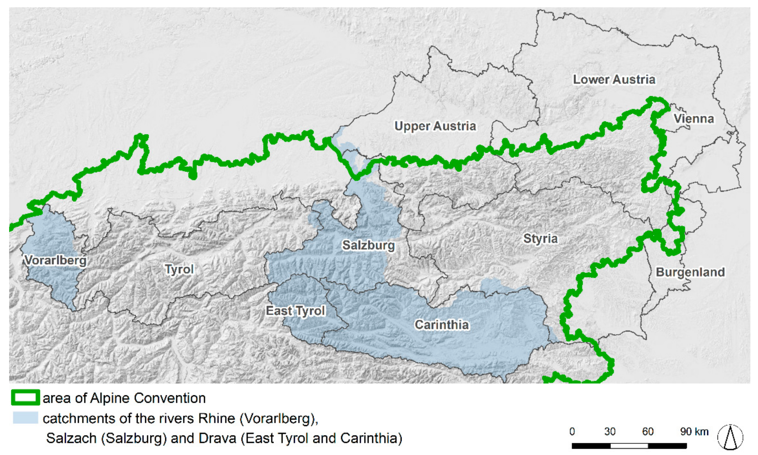
2.1. Study Area
2.2. Data
2.3. Methods
2.3.1. Human Transformation of Alpine Water Bodies
2.3.2. Settlement Development
2.3.3. Agricultural Land
3. Results
3.1. Human Transformation of Alpine Water Bodies
3.2. Land Use in Flood-Prone Areas
3.2.1. Settlement Development
3.2.2. Agricultural Land
4. Discussion
5. Conclusions
- (1)
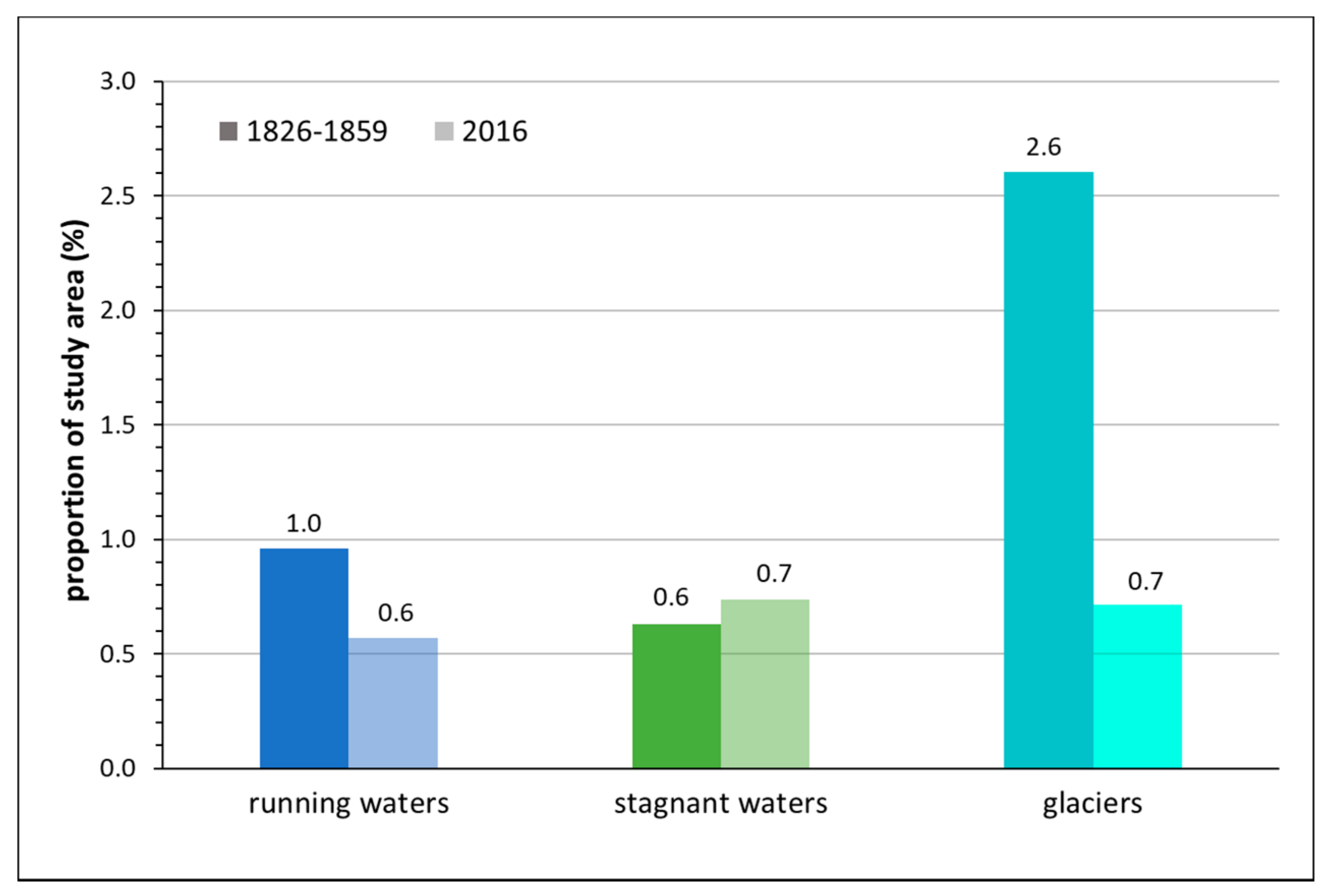
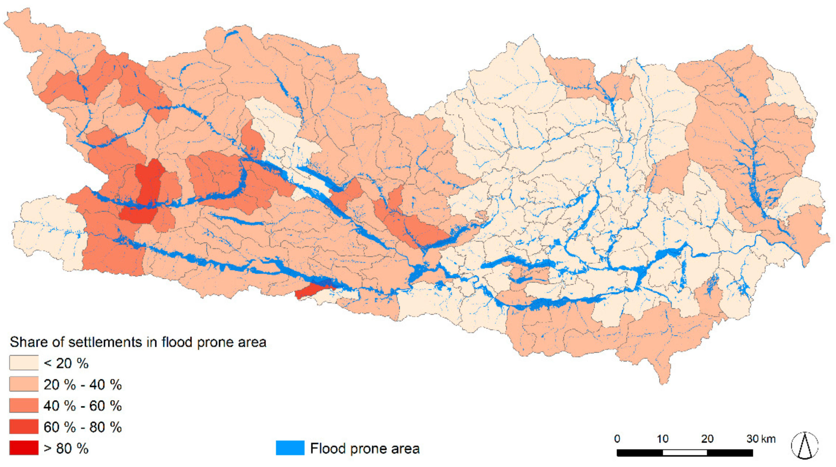
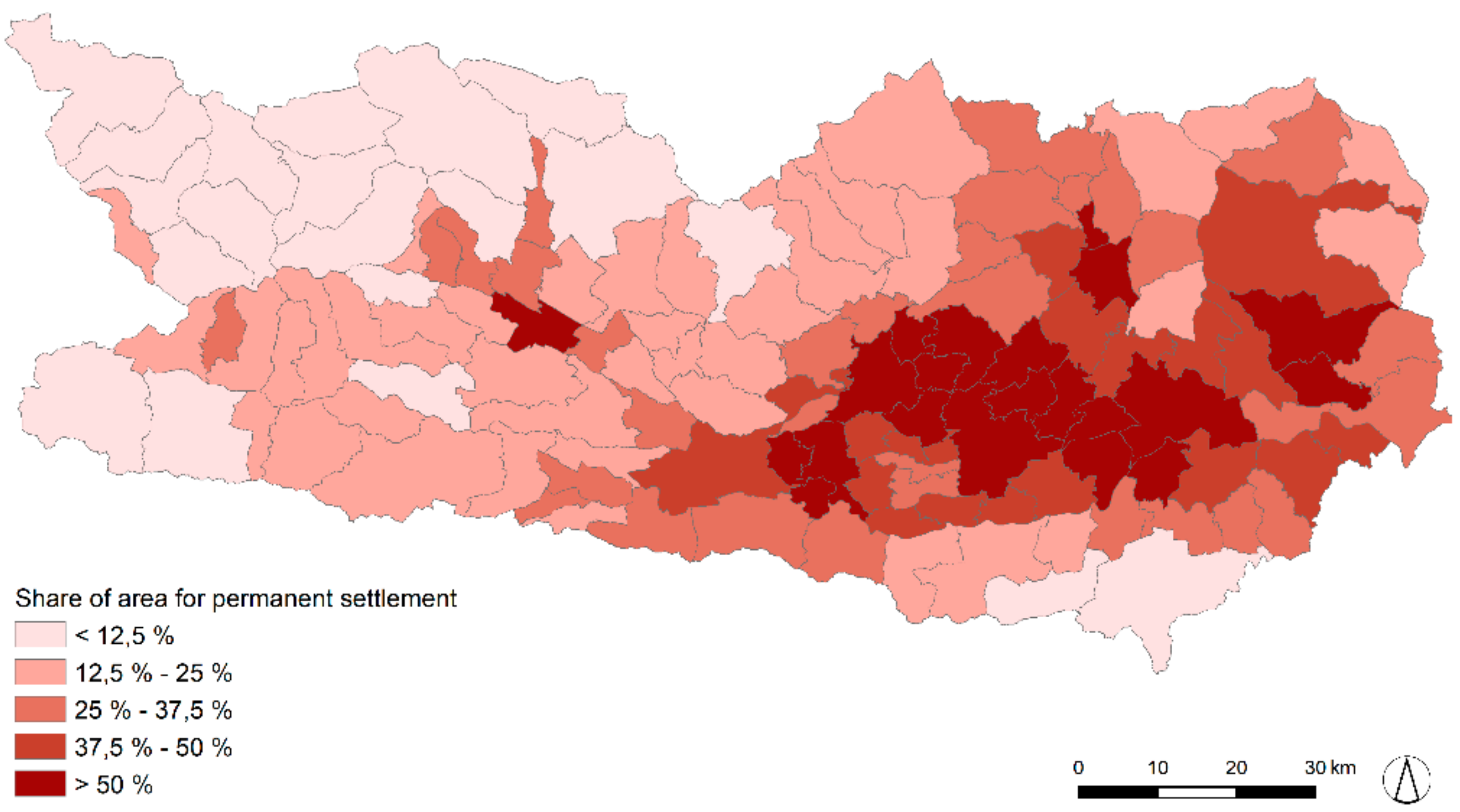
- How did water bodies and settlements in flood-prone areas change between 1826–1857 and 2016 in Austrian Alpine regions? In the past, one important goal of flood prevention was making space for new settlements and intensifying agricultural production, which led to a decrease in rivers and streams by 40%. Flood-prone areas (potentially affected by a 300-year flood) are nowadays more intensely used by settlements than in the mid-19th century. The amount of settlement areas located in flood-prone areas rose from 21% to 29%; flood damage potential is therefore increasing.
- (2)
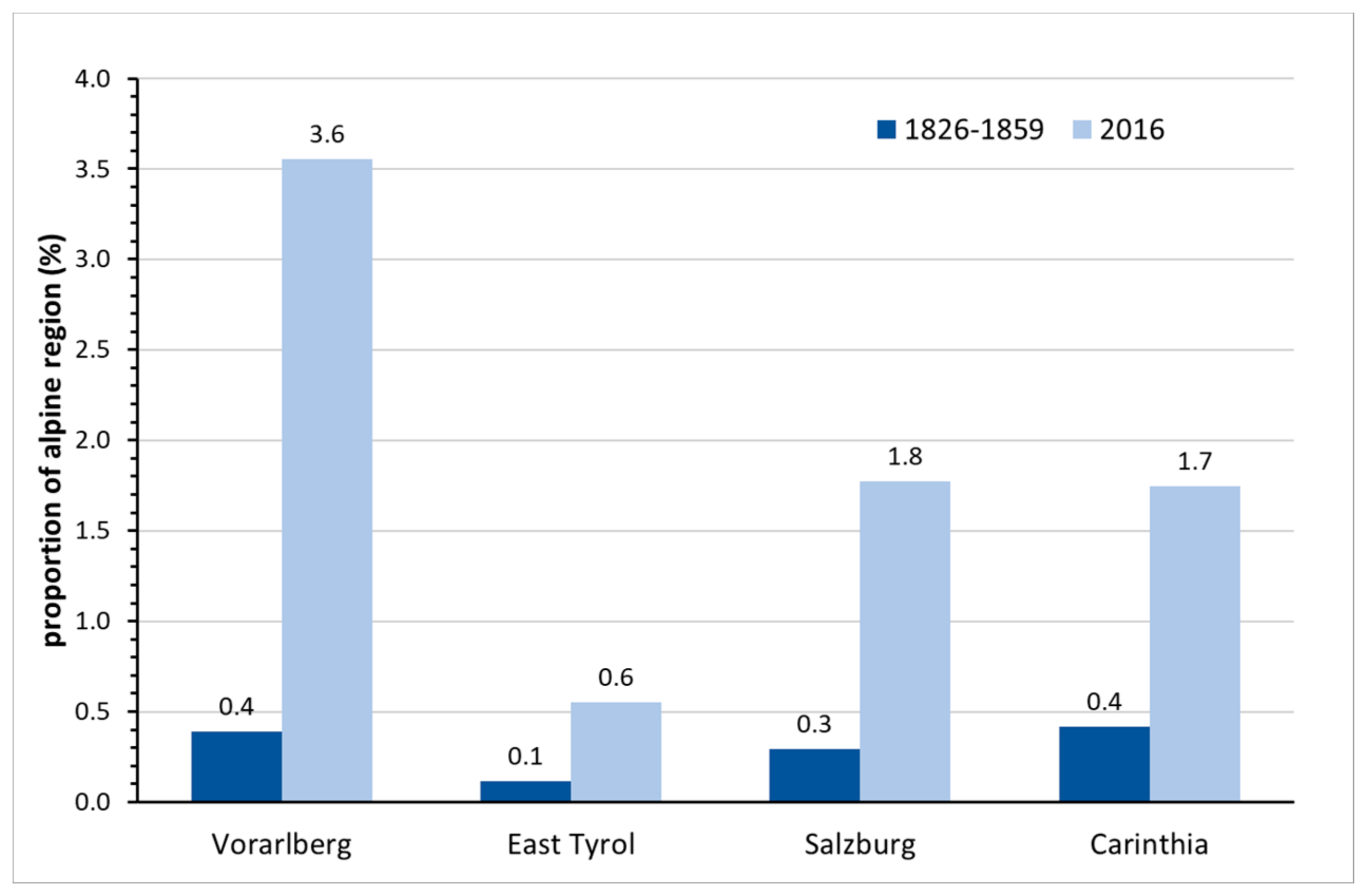
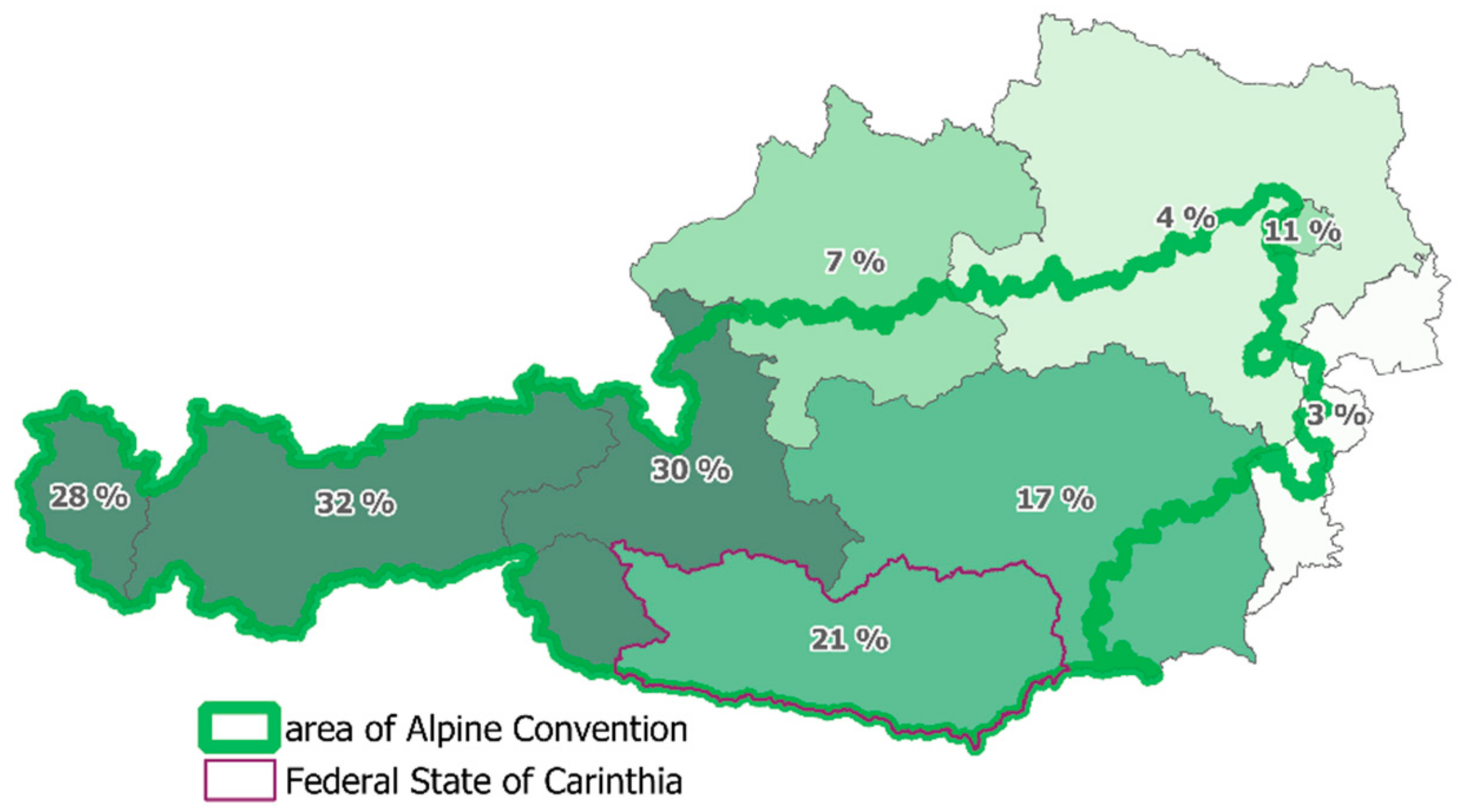
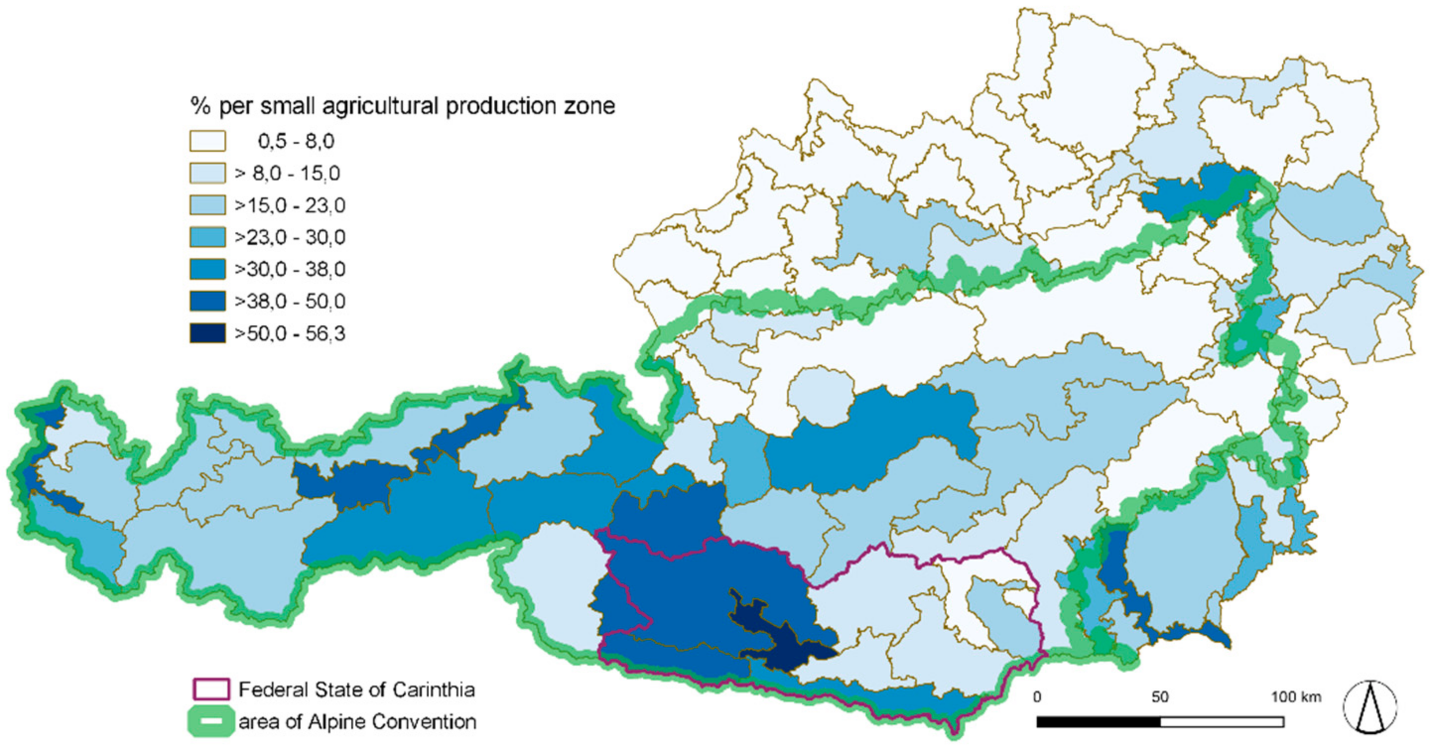
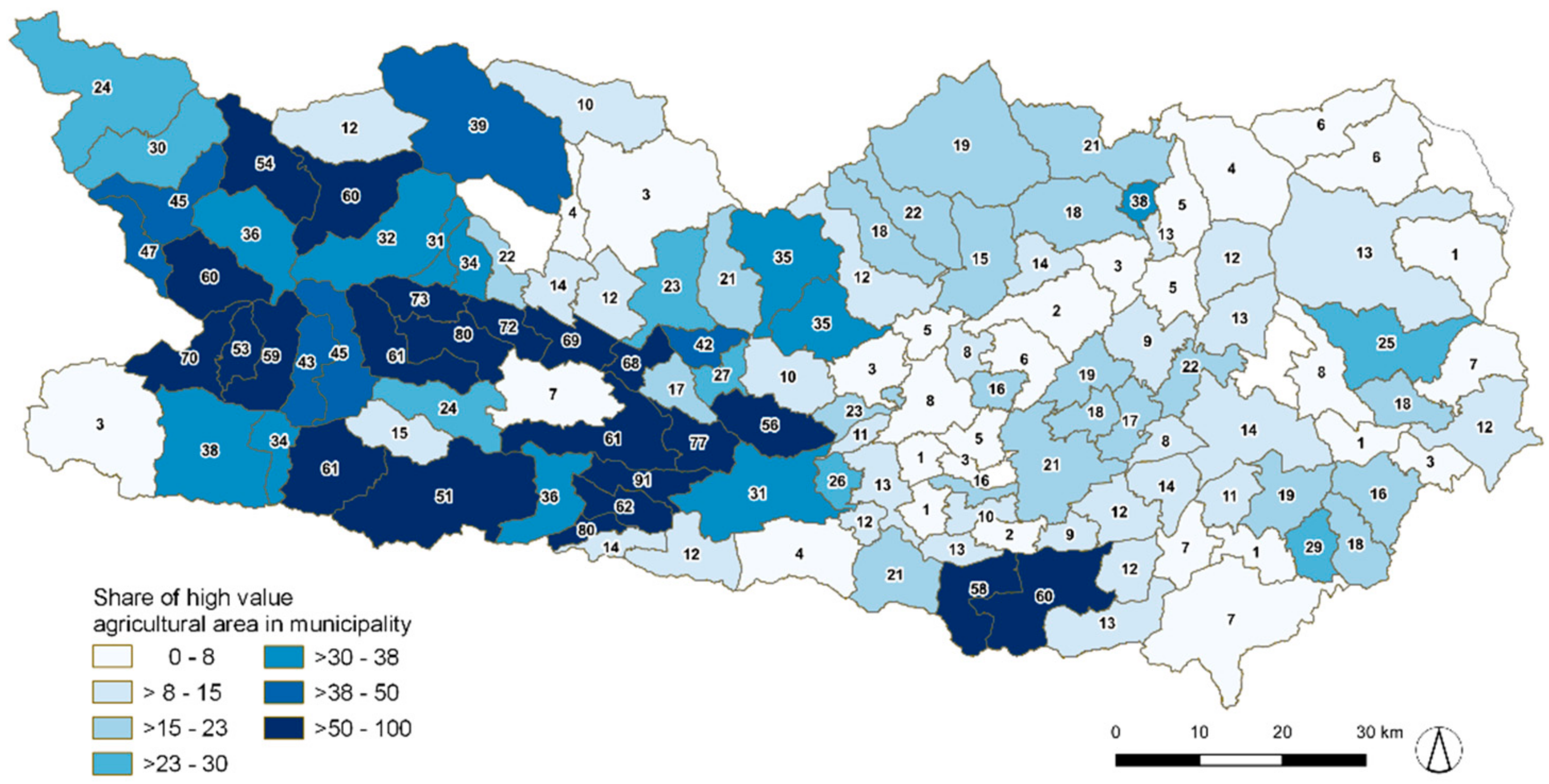
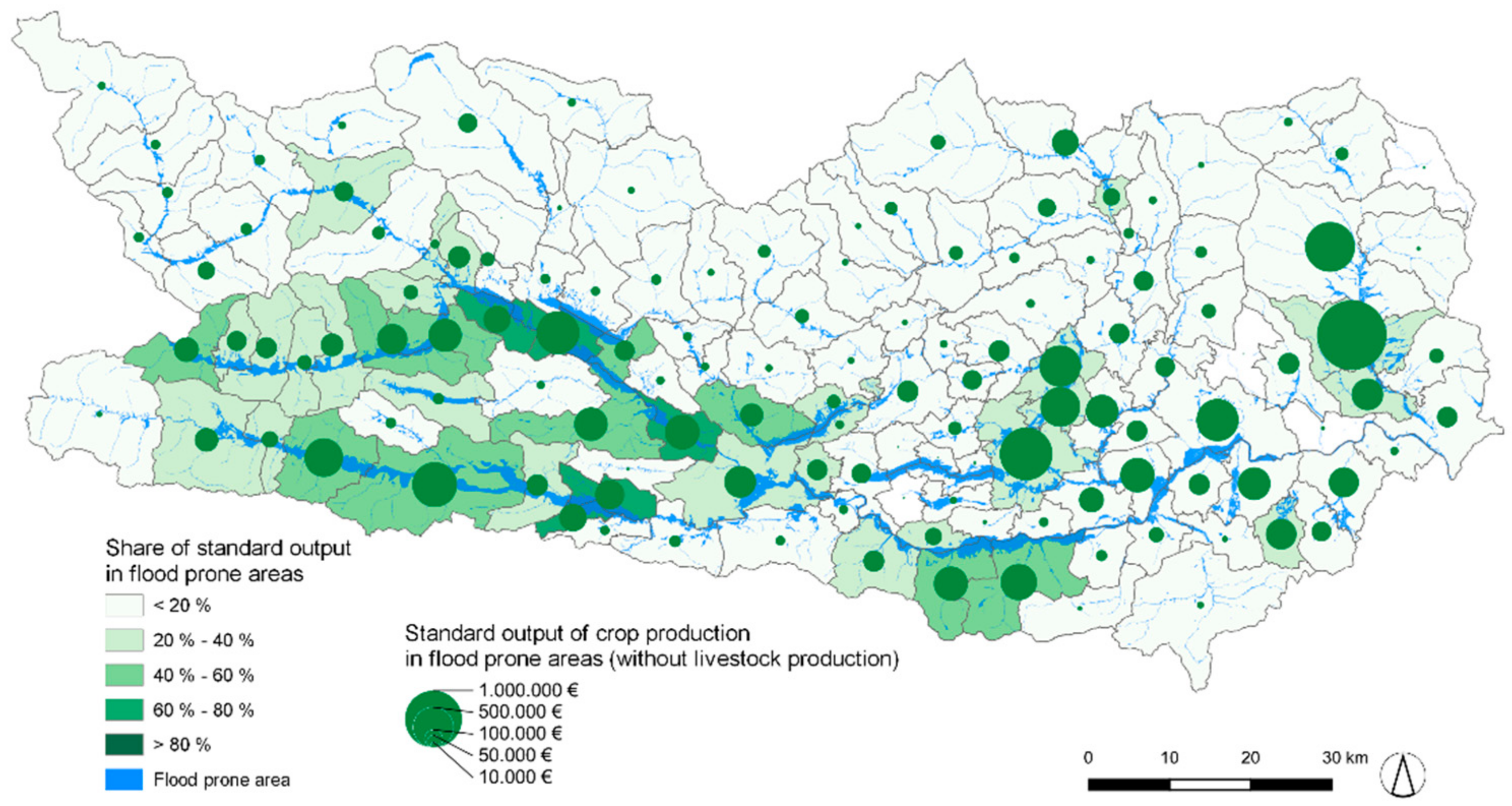
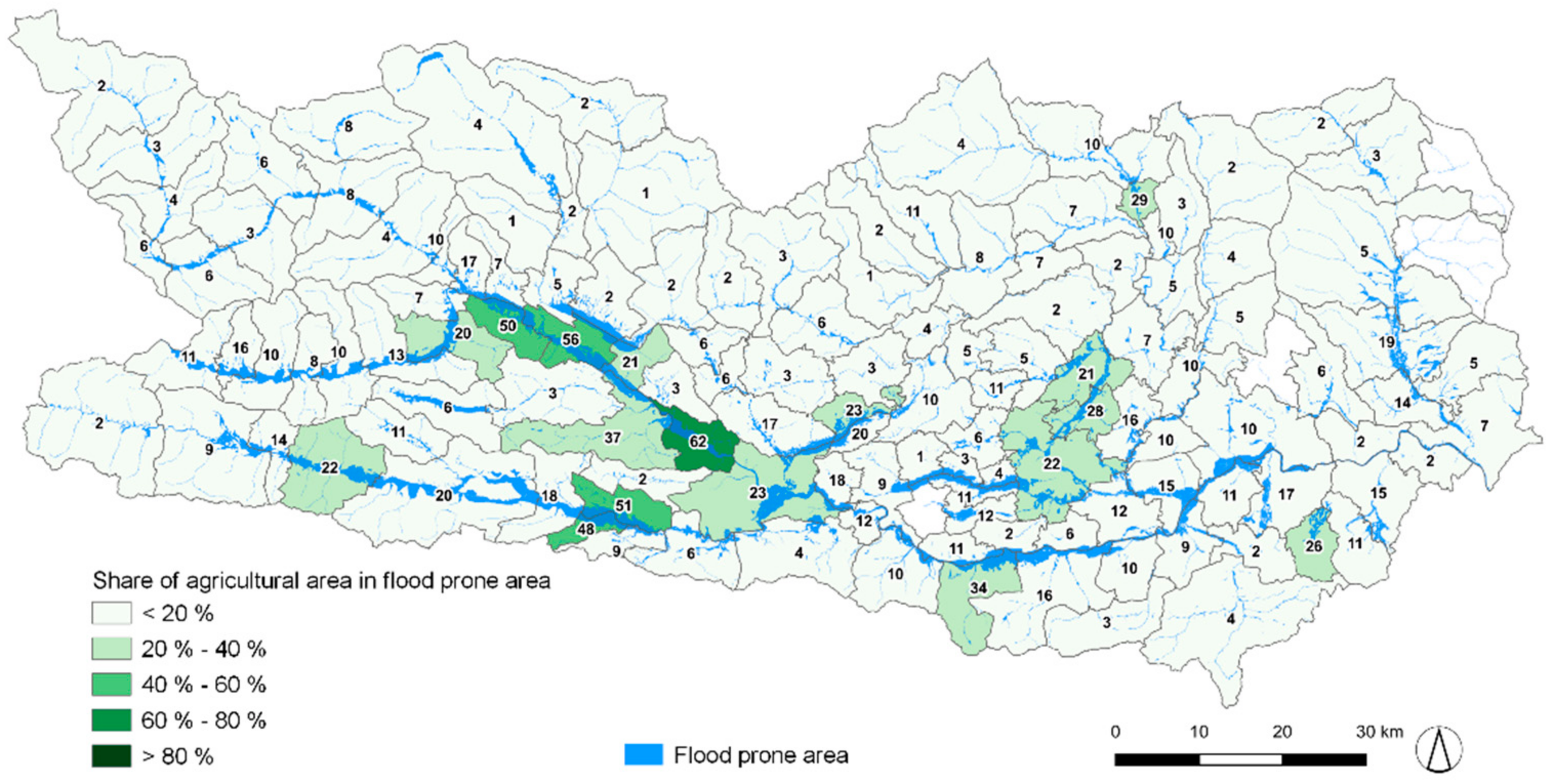
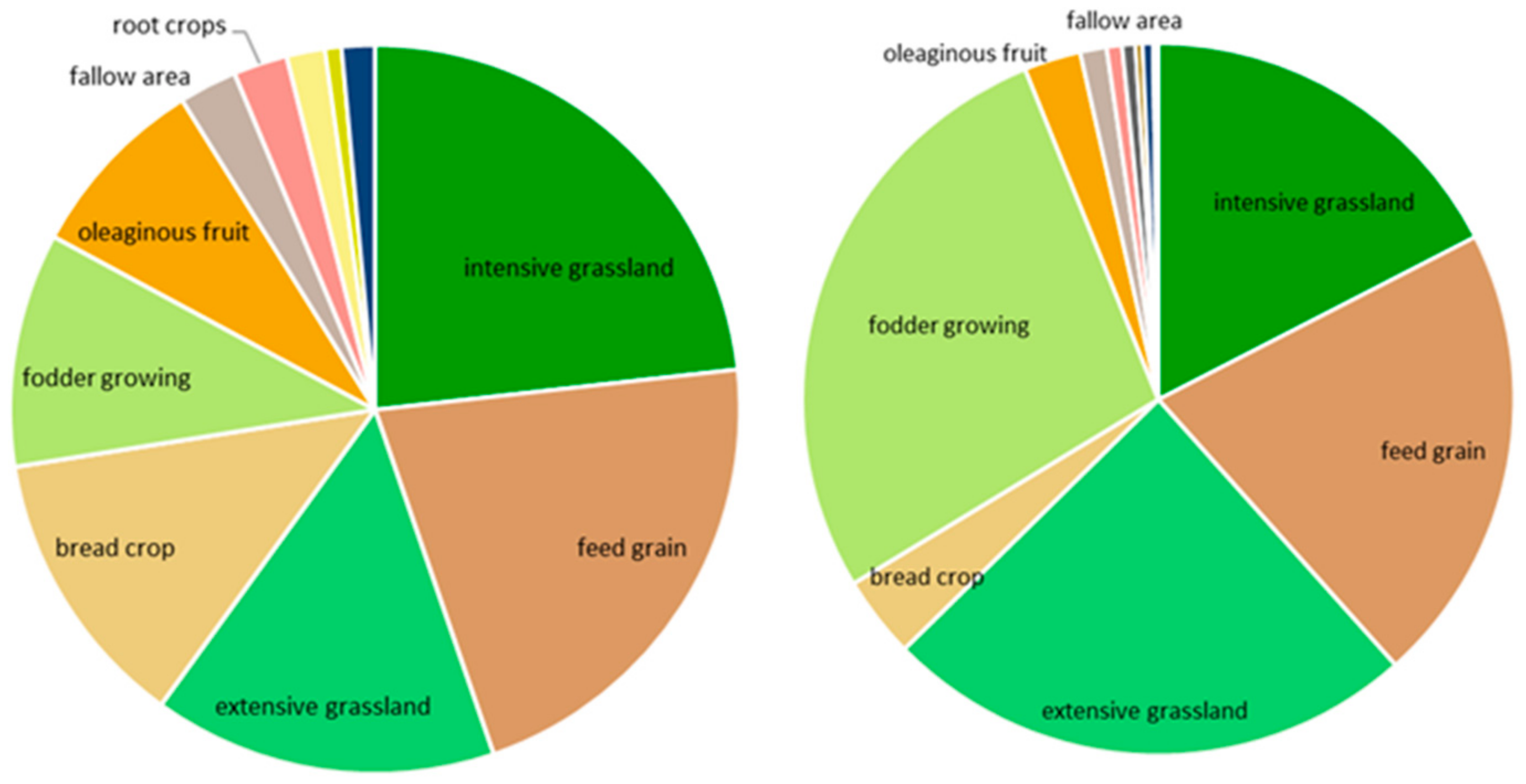
- How are flood-prone areas in Alpine regions currently used (focus on settlements and agriculture)? The regional analysis of settlements located in flood-prone areas shows that in pronounced mountain regions, a higher percentage of settlements is affected by flooding. Flood-prone areas are also needed for agricultural production; 7.7% of agricultural areas in Austria are located in flood-prone areas. Looking at valuable agricultural land, 12% is affected by flooding; however, the percentage is higher in Alpine regions. In Carinthia, for example, 21% of valuable agricultural land is located in flood-prone areas.
Author Contributions
Funding
Institutional Review Board Statement
Informed Consent Statement
Data Availability Statement
Conflicts of Interest
Appendix A


References
- World Bank. Cities and Flooding; The World Bank: Washington, DC, USA, 2012; ISBN 978-0-8213-8866-2. [Google Scholar]
- Blöschl, G.; Viglione, A.; Merz, R.; Parajka, J.; Salinas, J.L.; Schöner, W. Auswirkungen des Klimawandels auf Hochwasser und Niederwasser. Österreichische Wasser und Abfallwirtschaft 2011, 63, 21–30. [Google Scholar] [CrossRef]
- Blöschl, G.; Blaschke, A.P.; Haslinger, K.; Hofstätter, M.; Parajka, J.; Salinas, J.; Schöner, W. Auswirkungen der Klimaänderung auf Österreichs Wasserwirtschaft—ein aktualisierter Statusbericht. Österreichische Wasser und Abfallwirtschaft 2018, 70, 462–473. [Google Scholar] [CrossRef] [Green Version]
- Barredo, J.I. Normalised flood losses in Europe: 1970–2006. Nat. Hazards Earth Syst. Sci. 2009, 9, 97–104. [Google Scholar] [CrossRef]
- Löschner, L.; Herrnegger, M.; Apperl, B.; Senoner, T.; Seher, W.; Nachtnebel, H.P. Flood risk, climate change and settlements development: A micro-scale assessment of Austria municipalities. Reg. Environ. Change 2017, 17, 311–322. [Google Scholar] [CrossRef] [Green Version]
- Nachtnebel, H.P.; Apperl, B. Beurteilung des Hochwasser-Schadenspotenzials unter dynamischen Bedingungen. Österr Wasser- und Abfallw 2015, 67, 120–130. [Google Scholar] [CrossRef]
- Schanze, J. The long way towards tolerable flood risks—Initial lessons learnt from the recent Central European floods. J. Flood Risk Manag. 2013, 6, 167–168. [Google Scholar] [CrossRef]
- Klijn, F.; Samuels, P.; van Os, A. Towards flood risk management in the EU: State of affairs with examples from various European countries. Int. J. River Basin Manag. 2008, 6, 307–321. [Google Scholar] [CrossRef]
- Samuels, P.; Klijn, F.; Dijkman, J. An analysis of the current practice of policies on river flood risk management in different countries. Irrig. Drain. 2006, 55, S141–S150. [Google Scholar] [CrossRef]
- Greiving, S. Räumliche Planung und Risiko; Gerling Akad. Verl.: Munich, Germany, 2002; ISBN 3-932425-50-2. [Google Scholar]
- Sayers, P.; Yuanyuan, L.; Galloway, G.; Penning-Rowsell, E.C.; Fuxin, S.; Kang, W.; Yiwei, C.; LeQuesne, T. Flood Risk Management A Strategic Approach; Asian Development Bank: Mandaluyong City, Philippines, 2013. [Google Scholar]
- Müller, U. Hochwasserrisikomanagement: Theorie und Praxis; Vieweg+Teubner Verlag/GWV Fachverlage GmbH Wiesbaden: Wiesbaden, Germany, 2010; ISBN 978-3-8348-1247-6. [Google Scholar]
- Löschner, L. The Spatial Turn in Flood Risk Management: A Case Study of Austria’s Changing Flood Policies. Ph.D. Thesis, University of Natural Resources and Life Sciences, Vienna, Austria, 2018. [Google Scholar]
- Van Ruiten, L.J.; Hartmann, T. The spatial turn and the scenario approach in flood risk management—Implementing the European Floods Directive in the Netherlands. AIMS Environ. Sci. 2016, 3, 697–713. [Google Scholar] [CrossRef]
- Warner, J.F.; van Buuren, A.; Edelenbos, J. Making Space for the River: Governance Experiences with Multifunctional River Flood Management in the US and Europe; IWA Publishing: London, UK, 2012; ISBN 9781780401133. [Google Scholar]
- Rijke, J.; van Herk, S.; Zevenbergen, C.; Ashley, R. Room for the River: Delivering integrated river basin management in the Netherlands. Int. J. River Basin Manag. 2012, 10, 369–382. [Google Scholar] [CrossRef]
- Busscher, T.; van den Brink, M.; Verweij, S. Strategies for integrating water management and spatial planning: Organising for spatial quality in the Dutch “Room for the River” program. J. Flood Risk Manag. 2019, 12, e12448. [Google Scholar] [CrossRef] [Green Version]
- Verweij, S.; Busscher, T.; van den Brink, M. Effective policy instrument mixes for implementing integrated flood risk management: An analysis of the ‘Room for the River’ program. Environ. Sci. Policy 2021, 116, 204–212. [Google Scholar] [CrossRef]
- Hartmann, T. Den Flüssen mehr Raum geben—Umsetzungsrestriktionen in Recht und Praxis. Raumforschung und Raumordnung 2011, 69, 257–268. [Google Scholar] [CrossRef] [Green Version]
- Bogdan, E.A.; Beckie, M.A.; Caine, K.J. Making room for nature? Applying the Dutch Room for the River approach to flood risk management in Alberta, Canada. Int. J. River Basin Manag. 2020, 1–13. [Google Scholar] [CrossRef]
- Pardoe, J.; Penning-Rowsell, E.; Tunstall, S. Floodplain conflicts: Regulation and negotiation. Nat. Hazards Earth Syst. Sci. 2011, 11, 2889–2902. [Google Scholar] [CrossRef] [Green Version]
- Hohensinner, S.; Egger, G.; Muhar, S.; Vaudor, L.; Piégay, H. What remains today of pre-industrial Alpine rivers? Census of historical and current channel patterns in the Alps. River Res. Applic. 2021, 37, 128–149. [Google Scholar] [CrossRef]
- Habersack, H.; Bürgel, J.; Kanonier, A. FloodRisk II: Vertiefung und Vernetzung Zukunftsweisender Umsetzungsstrategien Zum Integrierten Hochwassermanagement; Synthesebericht: Vienna, Austria, 2009. [Google Scholar]
- Rohde, S.; Hostmann, M.; Peter, A.; Ewald, K.C. Room for rivers: An integrative search strategy for floodplain restoration. Landsc. Urban Plan. 2006, 78, 50–70. [Google Scholar] [CrossRef]
- Trautwein, C.; Schinegger, R.; Schmutz, S. Cumulative effects of land use on fish metrics in different types of running waters in Austria. Aquat. Sci. 2012, 74, 329–341. [Google Scholar] [CrossRef] [Green Version]
- Mantyka-Pringle, C.S.; Martin, T.G.; Moffatt, D.B.; Linke, S.; Rhodes, J.R. Understanding and predicting the combined effects of climate change and land-use change on freshwater macroinvertebrates and fish. J. Appl. Ecol. 2014, 51, 572–581. [Google Scholar] [CrossRef]
- Ceola, S.; Laio, F.; Montanari, A. Satellite nighttime lights reveal increasing human exposure to floods worldwide. Geophys. Res. Lett. 2014, 41, 7184–7190. [Google Scholar] [CrossRef]
- Cammerer, H.; Thieken, A.H.; Verburg, P.H. Spatio-temporal dynamics in the flood exposure due to land use changes in the Alpine Lech Valley in Tyrol (Austria). Nat. Hazards 2013, 68, 1243–1270. [Google Scholar] [CrossRef]
- Fuchs, S.; Margreth, K.; Zischg, A. A spatiotemporal multi-hazard exposure assessment based on property data. Nat. Hazards Earth Syst. Sci. 2015, 15, 2127–2142. [Google Scholar] [CrossRef] [Green Version]
- Grüneis, H.; Schroll, K.; Wagner, K. The Role of Agriculture in Flood Risk Management in Austria—Conflicts and Challenges. JESE-B 2021, 10, 112–127. [Google Scholar] [CrossRef]
- Agrawala, S. Climate Change in the European Alps: Adapting Winter Tourism and Natural Hazards Management; OECD Organisation for Economic Co-Operation and Development: Paris, France, 2007; ISBN 92-64-03168-5. [Google Scholar]
- Alpine Convention. Demographic Changes in the Alps: Report on the State of the Alps. Alpine Convention Alpine Signals—Special Edition 5, Bozen. 2015. Available online: https://www.alpconv.org/fileadmin/user_upload/Publications/RSA/RSA5_EN.pdf (accessed on 7 February 2022).
- Umweltbundesamt. Flächeninanspruchnahme. Available online: https://www.umweltbundesamt.at/umweltthemen/boden/flaecheninanspruchnahme (accessed on 7 February 2022).
- Löschner, L.; Eder, M.; Herrnegger, M.; Hogl, K.; Nordbeck, R.; Scherhaufer, P.; Schober, B.; Seher, W.; Wesemann, J.; Zahnt, N.; et al. RegioFEM—Informing future-oriented flood risk management at the regional scale (Part I). J. Flood Risk Manage. 2021, 15, e12754. [Google Scholar] [CrossRef]
- Hohensinner, S.; Atzler, U.; Berger, M.; Bozzetta, T.; Höberth, C.; Kofler, M.; Rapottnig, L.; Sterle, Y.; Haidvogl, G. Land Use and Cover Change in the Industrial Era: A Spatial Analysis of Alpine River Catchments and Fluvial Corridors. Front. Environ. Sci. 2021, 9, 647247. [Google Scholar] [CrossRef]
- GeoVille Information Systems. Cadasterenv—Final Report (TD-9): Public Version I 1.0. Available online: https://www.landinformationsystem.at/#/lisa/overview (accessed on 23 December 2021).
- BMLFUW; BAB. INVEKOS-Datenpool 2017 des BMLFUW. Available online: https://info.bmlrt.gv.at/themen/landwirtschaft/eu-agrarpolitik-foerderungen/direktzahlungen/Invekos.html (accessed on 23 January 2022).
- Buckel, J.; Otto, J.-C. The Austrian Glacier Inventory GI 4 (2015) in ArcGis (shapefile) Format; PANGAEA: Bremen, Germany, 2018. [Google Scholar]
- Ramm, F.; OpenStreetMap Data in Layered GIS Format. Technical Report. Available online: https://download.geofabrik.de/europe/austria.html (accessed on 23 December 2021).
- Muhar, S.; Grüner, B.; Böck, K.; Scheikl, S.; Becsi, R. SPARE Synthesis Report: "Balancing River Protection Needs, Ecosystem Functions and Human Uses"; University of Natural Resources and Life ServicesL: Vienna, Austria, 2018. [Google Scholar]
- Haslmayr, H.-P.; Baumgarten, A.; Schwarz, M.; Huber, S.; Prokop, G.; Sedy, K.; Krammer, C.; Murer, E.; Pock, H.; Rodlauer, C.; et al. BEAT—Bodenbedarf für die Ernährungssicherung in Österreich: Endbericht zum Forschungsprojekt Nr. 100975; Vienna, Austria. 2018. Available online: https://dafne.at/content/report_release/aa85879d-af0f-4273-a1e2-b7f1d7178d41_0.pdf (accessed on 23 December 2021).
- BAB. Standard-Output-Koeffizienten der Pflanzlichen Erzeugung nach Schlagnutzungsarten; BAB: Vienna, Austria, 2021. [Google Scholar]
- BMLRT. Grüner Bericht 2021 Die Situation der österreichischen Land- und Forstwirtschaft: Gemäß §9 des Landwirtschaftgesetzes; BMLRT: Vienna, Austria, 2021; Available online: https://gruenerbericht.at/cm4/jdownload/send/2-gr-bericht-terreich/2393-gb2021 (accessed on 23 December 2021).
- Papilloud, T.; Röthlisberger, V.; Loreti, S.; Keiler, M. Flood exposure analysis of road infrastructure—Comparison of different methods at national level. Int. J. Disaster Risk Reduct. 2020, 47, 101548. [Google Scholar] [CrossRef]
- Lebiedzinski, K.; Fürst, J.; Schulz, K.; Herrnegger, M. Possible impacts of a hydropower reservoir on the flood hazard of an Alpine valley. In Proceedings of the EGU General Assembly 2020, Vienna, Austria, 3–8 May 2020. [Google Scholar]
- Jansson, P.; Hock, R.; Schneider, T. The concept of glacier storage: A review. J. Hydrol. 2003, 282, 116–129. [Google Scholar] [CrossRef]
- Früh-Müller, A.; Wegmann, M.; Koellner, T. Flood exposure and settlement expansion since pre-industrial times in 1850 until 2011 in north Bavaria, Germany. Reg. Environ. Change 2015, 15, 183–193. [Google Scholar] [CrossRef] [Green Version]
- Serrano-Notivoli, R.; Mora, D.; Ollero, A.; Sánchez-Fabre, M.; Sanz, P.; Saz, M.Á. Ocupación de la llanura aluvial e inundaciones en el Pirineo Central. CIG 2017, 43, 309. [Google Scholar] [CrossRef] [Green Version]
- Poppe, M.; Muhar, S.; Gregory, E.; Stefan, S. Status quo der österreichischen Flusslandschaften: Erfassung und Bilanzierung der Eingriffe und Nutzungen. Österreichische Wasser- und Abfallwirtschaft 2003, 7–8, 122–128. [Google Scholar]
- Haidvogl, G.; Eberstaller, J.; Eberstaller-Fleischanderl, D.; Fraiß, B.; Gabriel, H.; Hohensinner, S. Historische Landnutzung und Siedlungsentwicklung in Flussauen und Hochwasserschutz: Das Beispiel der Traisen und St. Pöltens 1870–2000. Österr Wasser- und Abfallw 2018, 70, 305–315. [Google Scholar] [CrossRef] [Green Version]
- Merz, B. Hochwasserrisiken: Grenzen und Möglichkeiten der Risikoabschätzung Mit 33 Tabellen; Schweizerbart: Stuttgart, Germany, 2006; ISBN 3-510-65220-7. [Google Scholar]
- Burby, R.J. Hurricane Katrina and the Paradoxes of Government Disaster Policy: Bringing About Wise Governmental Decisions for Hazardous Areas. ANNALS Am. Acad. Political Soc. Sci. 2006, 604, 171–191. [Google Scholar] [CrossRef] [Green Version]
- Di Baldassarre, G.; Kreibich, H.; Vorogushyn, S.; Aerts, J.; Arnbjerg-Nielsen, K.; Barendrecht, M.; Bates, P.; Borga, M.; Botzen, W.; Bubeck, P.; et al. Hess Opinions: An interdisciplinary research agenda to explore the unintended consequences of structural flood protection. Hydrol. Earth Syst. Sci. 2018, 22, 5629–5637. [Google Scholar] [CrossRef] [Green Version]
- Zischg, A.; Costa, R.; Flury, C.; Schild, A. Einfluß der landwirtschaftlichen Bewirtschaftung auf alpine Naturgefahren eine zusammenfassende Betrachtung. In Proceedings of the 12th Congress INTERPRAEVENT, Grenoble, France, 23–26 April 2012. [Google Scholar]


Publisher’s Note: MDPI stays neutral with regard to jurisdictional claims in published maps and institutional affiliations. |
© 2022 by the authors. Licensee MDPI, Basel, Switzerland. This article is an open access article distributed under the terms and conditions of the Creative Commons Attribution (CC BY) license (https://creativecommons.org/licenses/by/4.0/).
Share and Cite
Junger, L.; Hohensinner, S.; Schroll, K.; Wagner, K.; Seher, W. Land Use in Flood-Prone Areas and Its Significance for Flood Risk Management—A Case Study of Alpine Regions in Austria. Land 2022, 11, 392. https://doi.org/10.3390/land11030392
Junger L, Hohensinner S, Schroll K, Wagner K, Seher W. Land Use in Flood-Prone Areas and Its Significance for Flood Risk Management—A Case Study of Alpine Regions in Austria. Land. 2022; 11(3):392. https://doi.org/10.3390/land11030392
Chicago/Turabian StyleJunger, Lena, Severin Hohensinner, Karin Schroll, Klaus Wagner, and Walter Seher. 2022. "Land Use in Flood-Prone Areas and Its Significance for Flood Risk Management—A Case Study of Alpine Regions in Austria" Land 11, no. 3: 392. https://doi.org/10.3390/land11030392