
Typing Colonial Perceptions of Carrum Carrum Swamp: The Expected and the Surprising


Monash Art Design and Architecture, Monash University, Caulfield East, Melbourne, VIC 3145, Australia
Land 2022, 11(2), 311; https://doi.org/10.3390/land11020311
Submission received: 3 January 2022
/
Revised: 11 February 2022
/
Accepted: 11 February 2022
/
Published: 18 February 2022
(This article belongs to the Special Issue Celebrating 25 Years of World Wetlands Day)
Abstract
:Carrum Carrum Swamp was a vast wetland to the south-east of Melbourne, Victoria, Australia, at the time that it was first sighted by white colonists in 1803. By 1878, the colonists had commenced converting the swamp to dry land for agricultural and horticultural pursuits, and 100 years later it was predominantly residential land. Shifting values in the 1970s led to environmental concerns about water quality in local creeks and Port Phillip Bay and subsequent residential development on the former swamp included the construction of stormwater treatment wetlands. Perceptions of wetlands are now diverse, including positive perceptions that support their presence in urban settings. In contrast, traditionally, wetlands have been perceived negatively, as waste lands, leading to their drainage. Nevertheless, alternative, perhaps positive, perceptions could have existed, only to be overwhelmed by the negative perceptions driving drainage. Understanding the full range of past perceptions is important to ensure that the historical record is correct and to provide historical context to contemporary perceptions of wetlands. It will better equip natural resource managers and designers and managers of constructed wetlands in urban locations to ensure that wetlands are healthy, functioning and appreciated by their local and wider communities. Thus, the perceptions of Carrum Carrum Swamp by colonists from 1803 to 1878 were examined through qualitative content analysis of historical documents, and a typology was developed. Seven different perceptions were identified: scientific, premodern, exploitative, romantic, aesthetic, medico-mythic and ecological. Most could be traced to the colonists’ predominantly British heritage, but one perception arose in the colony in response to the specific environmental conditions that the colonists encountered. This ecological perception valued wetlands as places of predictable water supply in a land of unpredictable rainfall. It recognised wetlands as part of a broader hydrological system, with influences on the local climate. Its proponents promoted the need for a different approach to the management of wetlands than in Britain and Europe. Nevertheless, a dominant exploitative perception prevailed, leading to the drainage of Carrum Carrum Swamp. The typology developed in this study will be useful for exploring perceptions of other wetlands, both colonial and contemporary.
1. Introduction
Traditionally, wetlands have been perceived as waste lands—dangerous, smelly, and unsightly places, breeding grounds of mosquitoes, snakes, and other pests, producers of dangerous gases, and physical obstacles to progress. Their value has lain in their potential as agricultural land, which could only be realized by drainage [1,2,3,4]. Draining wetlands has been described as “one of the oldest and commonest forms of land modification in American history” ([5], p. x); it is likely that this is the case across the developed world.
The draining of swamps has been explored in many publications, over decades. (e.g., [5,6,7,8,9], yet there are few studies of the past perceptions of specific wetlands, leading to their drainage. Meindl (2000) explores perceptions of the Floridian Everglades in the early 20th century [10]. He highlights the importance of beliefs and values in forming perceptions of the wetland, in the absence of direct knowledge of the place. Giblett (1996) describes different perceptions of wetlands during the establishment of Perth, Western Australia in the early 1800s [2]. Sornig (2018) provides insights into a range of perceptions of Dudley Flats and West Melbourne Swamp, which were the site of a shanty town well into the 20th century on the western edge of Melbourne, the capital of Victoria, Australia [11]. These studies show that past perceptions of swamps were more nuanced than convention allows.
Shifting values in the 1970s have led to environmental concerns about water quality in local creeks and waterbodies receiving stormwater discharge. Consequently, constructed wetlands are often part of stormwater management systems to harvest, treat, and reuse stormwater. Throughout Australia, sustainable stormwater management is being implemented, including the construction of treatment wetlands. Perceptions of wetlands are now diverse, including positive perceptions that support their presence in urban settings [12,13].
Many residential developments with constructed stormwater wetlands are being established on sites of former wetlands that have been drained. This is the case at Carrum Carrum Swamp.
Carrum Carrum Swamp was a vast wetland about 25 km to the south-east of what was to become Melbourne at the time it was first sighted by white colonists in 1803. The shallow trough that later became the swamp had been formed at the same time as Port Phillip Bay, after a period of glaciation 25 to 35 million years ago. The shoreline of the bay had since retreated a little, leaving sand dunes stranded inland behind which lay the swamp. Its area was more than 5000 ha, fed by what were to be named Dandenong and Eumemmerring Creeks, draining a total catchment of 735 km2. Two creeks flowed through the sand dunes to Port Phillip Bay, one at the northern edge of the swamp, a small inlet now known as Mordialloc Creek, and another towards its southern edge, Kananook Creek [14,15]. Much of the swamp contained permanent water, which remained stagnant for long periods. Water was only slowly released to the bay. Any heavy rainfall or sudden storm rapidly flooded the entire swamp and often extended for a large area beyond.
By 1878, the colonists had commenced converting the swamp to dry land for agricultural and horticultural pursuits. Always marginal land at best, most of the swamp had been drained within 100 years.
Since Australia was first colonized in 1788, and Victoria in the 1830s, the landscape has been transformed, for “a settler society, whether or not numerically dominant, was an invading, investing, transforming society with an internal frontier, both natural and cultural” ([16], p. 10). Transformation was a result of the perceptions, beliefs, and values that the colonists held of the new environment, which were translated into action. Perception of Carrum Carrum Swamp by settlers, neighbouring residents, citizens, government authorities, and the media has influenced this landscape change. These perceptions and underlying beliefs and values attached to the swamp have directed action towards it.
In this study, these perceptions are explored to determine if they were as narrow as popular opinion would have us believe or broader, akin to current perceptions towards wetlands. The recent studies of perception of contemporary Victorian wetlands [12,13] implemented an empirical landscape assessment methodology, based on a transactional human-landscape model [17,18]. The method involved interviews and questionnaires to reveal perceptions directly. In contrast, this study adopts an historical methodology, in which literature is reviewed, archival material consulted, and colonial newspapers read, to infer perceptions of Carrum Carrum Swamp during the early period of its colonization. An understanding of past perceptions is important to complement knowledge about current perceptions of wetlands and to ensure that the historical record is correct.
Landscape perception is an outcome of a transaction between a human observer and the landscape [19]. There are multiple nested scales at which this transaction can occur, but the perceptible realm comprises visible landscape patterns, evoking perceptual processes and affective reactions. The observer’s beliefs, values, knowledge, experience, and sociocultural context, amongst other personal attributes, will influence perception, as will attributes of the landscape, such as land type and use, spatial extent, ownership, etc. An aesthetic perceptual response is an obvious and immediate reaction to a landscape, but this is not the only way of perceiving a landscape. Meinig (1999) describes how one particular landscape can be perceived in ten different ways: as nature, habitat, artifact, system, problem, wealth, ideology, history, place, or aesthetic [20].
Different values that an observer holds for nature can inform the different ways of perceiving a landscape. Kellert (2009, 2012, 2018) proposes biophilic values held by humans towards nature, which can be expected to influence their perception of a natural landscape [21,22,23]. Originally there were nine values: humanistic, aesthetic, negativistic, dominionistic, utilitarian, ecologistic/scientific, naturalistic, symbolic, and moralistic [21]. More recently, Kellert has condensed them into eight: affection, attraction, aversion, control, exploitation, intellect, symbolism, and spirituality [22,23]. They are defined in Table 1. As values inherent in all humans [23], these might be expected to exist in colonial times, informing colonial perceptions of Carrum Carrum Swamp.
Differing landscape perceptions, beliefs and values shaped the five visions of the environment that Heathcote (1972) identified since colonization of Australia—scientific, romantic, colonial, national, and ecological [24]. A scientific vision drove the exploration of the southern Pacific in the late 18th century and developed after colonization into a curiosity into natural phenomena for their own sake and an interest in the environmental obstacles to successful colonization. There was great interest in Australia’s landscape, environment, and unique flora and fauna, leading to scientific descriptions and analysis. These involved both pure and applied scientific approaches, identifying local Australian patterns to help understand general global patterns, and collecting data as potential resources. A romantic vision existed concurrently with the scientific vision. In this vision, colonists were sympathetic to the Aborigines and regarded the countryside, known colloquially as bush, as almost a paradise. An important factor was the apparent lack of human influence, “a wilderness apparently unmodified by the hand of man” ([24], p. 87). The advance of civilization was unwelcomed. A colonial vision focused on the potential resources of the land, with both financial and aesthetic dimensions. The landscape was perceived as large, empty, unattractive expanses of wilderness. Its value lay in its potential as productive land, which would require the introduction of European plants and animals. Transformation involved land clearing, which was often rapid, widespread, and indiscriminate, with the goal to establish familiar and tidy agricultural landscapes. A national vision appeared from the late 1800s, with the celebration of the production of “a unique, Australian landscape” ([24], p. 91) from the original wilderness. This national vision reflected the establishment of cities as commercial and cultural centres. As cities became more urbane, a romantic dimension developed in this nationalism, which celebrated the bush in art and literature. Within this vision was a belief that the potential for national development was limited only by capital and labour. In the 20th century, an ecological vision emerged. This vision has characteristics of the scientific, romantic, and national visions. It emphasized the need to preserve the flora and fauna for their pure and applied scientific value. It implied a romantic conception of the natural environment as antidote to the built environment and the need for its appreciation by the public. There were also national overtones, in that preservation of the natural environment and its flora and fauna would generate pride and interest.
Heathcote [24] attributes a linear chronology to these visions, commencing with the scientific vision expressed by the explorers that ‘discovered’ and surveyed Australia and culminating in the ecological vision in the late 20th century. However, he cautions that one vision does not displace another, but each remains to create a dynamic complex of visions, some more conspicuous than others, changing over time.
This study draws on Kellert’s typology of nature values [21] and Heathcote’s typology of environmental visions [24] to interpret historical data to answer the following research question:
What were the perceptions of the colonists who first settled in Victoria, towards Carrum Carrum Swamp, between their first sighting in 1803 and settlement and drainage, up to 1878?
In answering this question, a typology is developed for wetland perceptions to guide future studies.
2. Methods
Historical material extending in time from the first observation of Carrum Carrum Swamp by white colonists in 1803 to its settlement and drainage, up to 1878, was consulted. Searches using the keywords ‘Carrum Carrum’, ‘Carrum Carrum Swamp’, ‘Carrum Swamp’, ‘Mordialloc Creek’, ‘Mordialloc Common’ located material in the State Library of Victoria, the Public Records Office of Victoria, National Library of Australia, Dandenong Library, City of Greater Dandenong council records, and Historical Society of Victoria. Sources included Victorian Parliamentary Papers with records of parliamentary debates in the Legislative Assembly and reports of parliamentary committees and commissions; Parliamentary Acts of Victoria; Victorian Government Gazettes; contemporary newspapers, e.g., The Argus, The Dandenong Journal, Mordialloc-Chelsea News; applications for land selection and letters from selectors to the Victorian Commissioner of Lands; Dandenong District Road Board and Dandenong Shire rate books and minute books. In addition, published personal memoirs and local histories were found. Letters to the Editor in Melbourne newspapers contained commentary about other swamps near Melbourne. This was included in the study to augment material directly relating to Carrum Carrum Swamp as it revealed perceptions towards wetlands more generally that material specifically relating to Carrum Carrum Swamp might not.
This material was content analysed qualitatively to infer perceptions of the first white colonists to see Carrum Carrum Swamp, settlers of the swamp, other citizens of Melbourne, state and local government politicians, colonial scientists appointed by the state government to the Swamp Commission, and the media. Quotations are given in the text to illustrate perceptions. Newspaper quotations are taken from The Argus. Public commentary on local issues was very active and often reported similarly in the various newspapers. To provide continuity of commentary, where necessary, quotations are drawn from this single newspaper.
Additional references were consulted to aid interpretation of perceptions and provide context to them.
3. Results
Colonial perceptions of Carrum Carrum Swamp between 1803 and 1878 can be characterized as scientific, premodern, exploitative, romantic, aesthetic, medico-mythic, or ecological. Six of these relate to Kellert’s nature values [21,22,23] and Heathcote’s environmental visions [24]. However, the premodern perception is not in either typology.
3.1. Scientific Perception
A scientific perception was revealed, which reflects Heathcote’s scientific vision in which there is a scientific curiosity about the natural environment and a desire to identify opportunities for settlement and development [24]. At Carrum Carrum Swamp, this is evident in diary entries and annotated maps of the first explorers to sight the swamp. Subsequent surveys described the land and its potential for agricultural development.
The first written account of Carrum Carrum Swamp, in the journal of the exploration of Port Phillip in 1803 by Charles Grimes, Acting Surveyor-General of New South Wales, reveals both pure and applied scientific interest. The journal was kept by James Flemming, a gardener, assigned to the expedition to assess soil quality [25]. The published journal includes the daily entries by Flemming and explanatory footnotes by the editor, J. J. Shillinglaw [26]. The swamp was described and thereby classified for its potential value as a resource. On Sunday 30 January 1803, Flemming noted that
“I ascended a hill (footnote—back of Frankston) where I could see eight or ten miles, hills without trees, narrow valleys with scrubby brush. The soil black, g[r]avelly sand; at a mile-and-a-half from the beach a run of fresh water to a lagoon. Came to a river (footnote—Cananook Creek); it was salt; traced it to the beach; crossed it up to the knees about a mile farther; went in about a quarter of a mile found a fine fresh water river about 30 feet wide, and deep enough for a boat; Mr. Grimes took the bearings of it; traced it six or eight miles; it runs in a parallel line with the sea.”
The following day, they
“crossed a neck of land about half a mile over (footnote—referring to Long Beach and Carrum Swamp); went along the beach a little way and ascended a hill; the country appearing very barren.”
On Wednesday, 2 February 1803, they came to
“a large swamp, with three lagoons in it, all dry. The land appears covered with water in wet seasons”.
On the map produced from Grimes’ survey [27], the area of Carrum Carrum Swamp is described as “Open and barren country” (Figure 1, indicated by red arrow).
On subsequent charts and maps produced of Port Phillip Bay and its shoreline, Carrum Carrum Swamp is always indicated, reflecting its potential as a resource for the colonists. At first its description is general, such as “Large swamp overgrown by reeds” in 1804 [28], “Swampy country” in 1827 [29] or “Swampy land” in 1836 [30]. With time, the swamp was named and its description on maps became more detailed, indicating the diversity of the swamplands and suggesting its potential for colonization and agriculture, e.g., “Sandy ridge”, “Open plain liable to winter floods black soil well grassed”, “Tea tree scrub”, “Fine agricultural soil lightly timbered with gum, cherry & lightwood”, “Fine agricultural land—partly subject to flood”, “Dense tea tree scrub water plentiful” [31].
3.2. Premodern Perception
A premodern perception of swamps is likely to have accompanied those colonists who first settled on Carrum Carrum Swamp as squatters. Their successful colonization would have depended on it. Sluyter (2002) contrasts the Modern West, those developed Western societies in which the natural and the social had become separate dichotomies, with the Premodern Rests, in which the natural and the social were intertwined [32]. Many colonists were from countries that had long adapted over centuries to living with coastal wetlands; their premodern perception of Carrum Carrum Swamp revealed in this study would have been shaped by their experience of similar coastal wetlands in England and would have, in turn, shaped their attitudes and actions towards the swamp. This premodern perception was expressed by the colonists utilising the swamp within its biogeophysical constraints, in which the social and the natural were not binaries but enmeshed. There is no equivalent to this premodern perception in either Kellert’s nature values [21,22,23] or Heathcote’s environmental visions [24].
By the time of colonization of Australia, many of the coastal wetlands of England had been transformed from their prehistoric mosaics of intertidal mudflats and more elevated vegetated saltmarshes to landscapes of arable land, pasture, and meadows [33]. Darby (1956) describes the transformation process in The Fens, an area of marsh in East Anglia on the east coast of England, edging The Wash, a large embayment of the North Sea [7]. It was a large flooded plain, with an area of 330,000 ha, with peat on the landward side and silt on the seaward, fed by rivers. Before large-scale drainage in the 17th century, The Fens consisted of open pastures and meadows, with reedy swamps and pools, connected by a network of channels. In winter, the entire area was covered with water, punctuated by islands. From medieval times, clusters of villages had been established on the high land, e.g., Isle of Ely, sharing common land for grazing and watering stock. Residents lived on the resources that The Fens provided: fishing, fowling, gathering reeds and rushes, and making salt within the marshes; making hay, grazing livestock, and cutting turves on the land less frequently inundated; and farming on the islands or higher arable land. The local economy was bound with the cycles in The Fens, with land practices based on tradition. Seasonal variation was accepted as inevitable, maybe even beneficial. For example, winter floods made the pasture richer; summer floods caused little damage. Although much of the southern part of The Fens had been drained by the 18th century, with a regular pattern of channels and dykes superimposed on the older natural streams, there were still areas of deep water and patches of swamp into the 19th century.
This was the inheritance of the most successful of the squatters who first settled Carrum Carrum Swamp in 1837. The northern half of the swamp was described in a survey in 1868 [34] as marshland, elevated 1–3 m above the level of the highest spring tides at the mouth of Mordialloc Creek. It was unwooded except for a few patches covered with tea tree or with red gum and honeysuckle (banksia). It flooded in wet seasons [35]. Morass, overgrown with reeds and sedge, covered half the rest of the swamp, less than 1 m above the highest observed spring tides at the mouth of Mordialloc Creek or about 1 m above the level of ordinary high water. This area had been described as swamp with permanent water in an earlier survey in 1866 [36], with loose peaty soil over sand. The rest of the swamp was sandy hillocks and flats, covered with scrub, fern or spear grass and lightly wooded with stunted eucalypts, banksia, and casuarina.
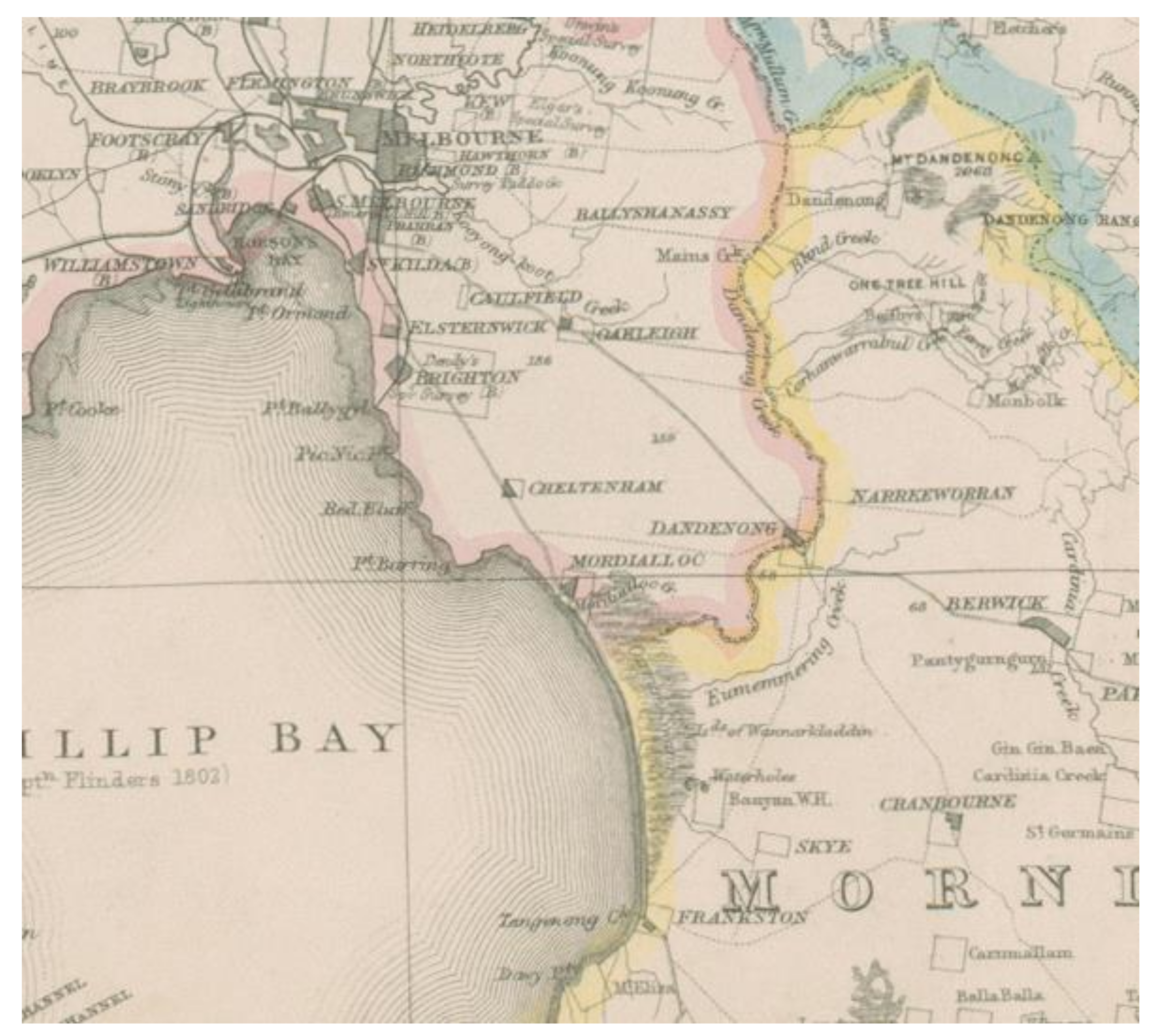
The attraction of land on Carrum Carrum Swamp to colonial settlers was plentiful water [15], either in Mordialloc or Eumemmerring Creek or the permanent water holes and lagoons along the creeks or in the swamp itself. In time, four runs were established by squatters on the swamp, vast holdings to graze cattle and sheep. That much of the swamp might be too wet at times to be grazed fully was less important than access to water. The land that was not permanently inundated was valued highly, “extensive plains of rich black loam covered in rib grass, one of the most nourishing grasses in Australia” (J. Hawdon, quoted in [15], p. 22). To be successful, the squatters had to work within the physical constraints of the swamp. Many of the squatters failed and, by 1847, there was a single large run in the southern part of the swamp operated by the Wedge brothers, known as Banyan Waterholes (Figure 2). The Wedges had come to Australia from East Anglia [15], so it is highly likely that they were familiar with a watery landscape such as Carrum Carrum Swamp and had the skills to manage it.
As British tradition dictated, a farmers’ common was also established on Carrum Carrum Swamp. An Aboriginal Reserve had been established at the mouth of Mordialloc Creek on the northern edge of the swamp in the early 1850’s [15]. With the colonial occupation of Carrum Carrum Swamp limited to the southern half, 2007 ha in the northern half of the swamp was declared a Farmers’ Common, under the Nicholson Land Act 1860, in February 1861 [37]. This farmers’ common at Mordialloc included the Aboriginal Reserve. It was extended twice so that by late 1866 it occupied the entire swamp from Mordialloc Creek, along the coast of Port Phillip Bay to the boundaries of the squatters’ holdings in the south. The farmers’ common allowed the benefits of grazing cattle (sheep were not allowed) to be shared by purchasers of land within 5 miles of the common [37,38,39,40,41,42,43,44]. Access to the common was particularly important during times of drought when the swamp, although drying out, would have supported more vegetation than elsewhere. The farmers using the common valued the land as their own, wishing to use the revenue from its rental for its improvement [45].
3.3. Exploitative Perception
An increasing concern for the potential resources of the new colony and a weariness with the unfamiliar landscape found expression in an exploitative perception of the landscape. This encompasses Heathcote’s concept of a colonial vision [24] and is associated with a utilitarian value of nature [21]. A broad-scale process of landscape change began, in which the natural landscape was modified to meet utilitarian needs of the colonists or their aesthetic preference. Landscape change in wetlands involved their drainage. The colonists’ aesthetic preferences were expressed in the conversion of wet land to dry land, as were the values that drove the change. Inevitably, this involved transformation of the colonial landscape to a predominantly British landscape, reflecting the preferences of the colonists.
Attitudes towards Carrum Carrum Swamp would have been influenced by the process of landscape change in wetland regions of England, from where many colonists came. In prehistoric times, the coastal wetlands in England were mosaics of intertidal mudflats and more elevated vegetated saltmarshes [33]. Freshwater peatlands developed on the inland areas, which were settled in the Roman period to exploit their natural resources. Some reclamation efforts were made late in this period, but most coastal wetlands were abandoned and reverted to their natural state by the end of the Roman period. Human settlement resumed during the Middle Ages when drainage efforts commenced [33]. The drainage process in The Fens marshland is well documented [7]. By the Middle Ages, local and individual effort had reclaimed the edges of the marshland. Legislation for comprehensive draining of The Fens was first passed in 1600, in response to a treatise by Humphrey Bradley in 1589. He proposed drainage of The Fens to increase the population of the area, to increase productivity for local, regional, national, and international trade, to provide employment and in “many other ways redound to the great advantage and strengthening of the nation” ([7], p. 68). Little drainage was achieved, however, until after passage of the Act for the draining the Great Level of the Fens, extending itself into the Counties of Northampton, Norfolk, Suffolk, Lincoln, Cambridge and Huntingdon, and the Isle of Ely, or some of them in 1649 [7]. By the 18th century, much of the southern part of The Fens had been drained, to take advantage of the fertility of the peat and silt lands for agriculture and to open the area for more settlement. By the 19th century, technological advance through the Industrial Revolution and improved agricultural practices had contributed to effective drainage of much of The Fens [7].
The colonization of Victoria at the time of the Industrial Revolution equipped the colonists with the technical skills to effect dramatic landscape change readily [8,16], bringing the colony into the Modern West [32]. They had access to technology that would enable them to implement changes consistent with their desire to exploit the land occupied by wetlands, their familiarity with transformed waterscapes in their home countries [46], and a legislative system to enforce them.
In Victoria, colonial attitudes that valued wetlands as a potential resource were enshrined in legislation, replicating the practice in Britain. A series of Land Acts was proclaimed, regulating the survey, selection, and sale of land in the colony. Acts relevant to Carrum Carrum Swamp were the Land Act 1862 [47], the Amending Land Act 1865 [48], and the Land Act 1869 [49].
Section 38 of the Amending Land Act 1865 legislated for the granting of a lease of Crown Land to anyone “willing to make and construct canals or to undertake works for the drainage or reclamation of any swamp or morass”. This did not apply to land simply subject to flood [50]. A Professional Board was appointed to inquire into applications in October 1865 [51]. It received several applications for schemes involving Carrum Carrum Swamp. Although much of the swamp was under permanent water, the thick layer of decaying organic matter and silt trapped in the swamp promised very fertile soil. In October 1865, Lockhart Morton applied for a lease of the entire Carrum Carrum Swamp. A lease for his scheme, details of which were not given, was recommended by the board, with the explanation that the land, currently drawing a revenue of £9 2 s. per annum, would be worth at least £4 or £5 per acre. Subsequently, objections were submitted on the grounds that “a portion of the so-called swamp was good grazing land” [52] and that construction of a canal was being considered [53]. In 1869, another proposal was canvassed, to lease a portion of the Carrum Carrum Swamp for sugar beet cultivation. The scheme was promoted to benefit the district and the colony, by the employment the lease would provide (anticipated to be 1500 [54]), and “the conversion of what is a barren waste into a luxuriant agricultural district” [55]. The issue of the lease was supported by 258 farmers and other residents of Mordialloc near the swamp. They believed that the proposal to drain the swamp and use it for growing sugar beet would open up several hundred hectares for cultivation and be the means of supplying the district with fresh water in the area and greatly preferred it to Morton’s proposal [54].
As The Argus anticipated on 30 April 1869 [56], soon the government believed that the value of Carrum Carrum Swamp lay in it being drained for agriculture: “in its undrained state it would be perfectly useless” ([57], p. 1079). The swamp had been surveyed in 1868 in preparation of its sale and schemes for its drainage were debated in Parliament. Ultimately, the cost of drainage was considered too great for either the government or an individual to bear ([57], p. 1144). Considering sale by auction inadvisable, the land was made available for selection.
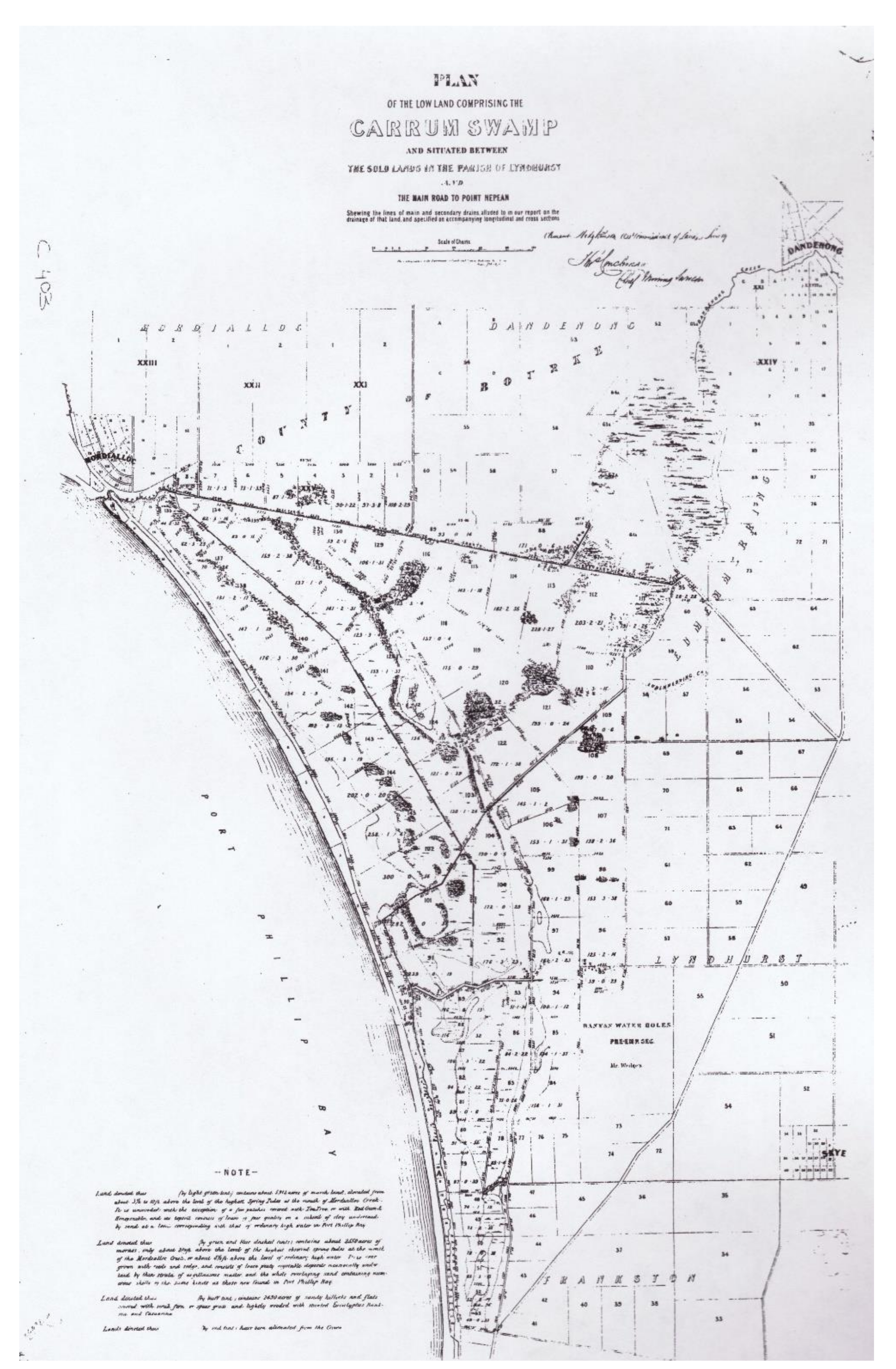
Land on Carrum Carrum Swamp was selected under the Land Act 1869 [49] (Figure 3). Strict conditions were specified in Section 20, which the selector was obliged to meet. These included the requirement to enclose the land “with a good and substantial fence”, to cultivate at least 1 acre out of every 10 acres, to occupy the allotment within 6 months of the issue of a licence for the duration of the licence (minimum residency of 2 ½ years), and to undertake substantial and permanent improvements to the value of £1 per acre by the end of the third year of the licence.
Most of the selectors of allotments on Carrum Carrum Swamp were seeking land from which they could make a living, as graziers, farmers, and market gardeners. To do so for many required drainage of the land; drainage was also necessary to meet the conditions of Section 20. Only allotments on the sandy hillocks and flats in the south of the swamp might have been able to support cultivation and allow fencing and construction of a residence.
A typical selector was Alfred Bishop, who wrote to the Secretary of Lands in 1878 that “the land in question is of no use to anyone unless drained” [58]. Norman McSwain wrote to the President of the Board of Lands and Works in 1876 that “Through the whole year three fourths of the land is under water and during the past winter there was not one acre dry in the whole of it…the land is not returning anything. I had five head of cattle and two horses on it but when the first flood came down last winter I found the cows over their knees in water where they had been for two days without any food and it was with no small difficulty I got them off so that it is very hard for a poor man to spend money on such land. When the proposed drainage is finished it will alter the case“ [59].
Edgar Pettit may have had different expectations. He was a basket maker and hoped to be able to grow willows on his selection [60,61], an undertaking that would require wet land, but his land was so wet “I cannot reside there to grow willows, and it is no good taking up ground to grow willows upon a mountain, and it is wet even now; I cannot go on with the fencing” ([61], p. 3).
3.4. Romantic Perception
Some colonists had a romantic perception of the landscape, as described by Heathcote, delighting in its “uncivilised” appearance, and dreading the inevitable changes of civilization [24]. They perceived the landscape as pristine, untouched by human activity. This is related to Kellert’s humanistic value [21]. Such an attitude was evident in the perception of Carrum Carrum Swamp by William Bruton, born in 1854. In his memoirs [62], he recalls the vegetation and bird life of the swamp of his childhood:
“When I first visited Carrum….the foreshore was a growth of honeysuckle ferns and wild currants, and when these trees were flowering, a large number of birds were seen. Magpies and crows preferred the other side of the swamp. The call of the Kookaburra was heard everywhere, and amongst the trees were wattle birds, leatherheads, woodpeckers, thrushes, kingfishers, robins and many different kinds of parrots, and as we camped near the swamp, we heard plovers chattering and chanting the whole night through. As we cannot go through the swamp we go around a large clump of swamp ti-tree, when—oh! wild turkeys—they know the human beings, and are up and off quickly.
But what are those tall things over yonder? A flock of native companions. Rare as they are, they are still birds, but they are far more conceited than any other bird. Note their stately stride; their very conceit of themselves constitutes the joy of life.
Here the gum trees lay prone where they have lain for hundreds of years, and others in the full glory of life send their spreading limbs and luxuriant foliage out, displaying their pride of life.
Here also are the possums in plenty, disporting themselves amongst the branches.
“The rich man has many goods, but here we have all we require. We eat, drink, and are merry, and the rich man has no grand busy tail as we have.” “Oh! That one out there and in the daytime, too. Look out pussy! If that gunman comes around the corner he may want you for dog’s food.””([62], pp. 4–5).
Bruton regretted the loss of the swamp, concluding
“And so it seems that the energy of the axeman, the drainer, the builder have turned the heavenly paradise of thousands of years, into a joy somewhat like unto the dog of old, racing with the jam tin, which rascally boys have attached to his tail”([62] p. 5).
In this romantic perception of swamps, changes inevitably associated with colonization were unwelcome.
3.5. Aesthetic Perception
An aesthetic perception, albeit negative, is evident amongst Victorian colonists, who regarded wetlands as unsightly as well as unproductive land. Heathcote describes aesthetic responses within the romantic, colonial, and national visions [24], whereas Kellert identifies aesthetic values of landscapes as a distinct category [21]. As perception is often primarily visual, a fundamental perceptual response when viewing a landscape is aesthetic [19]. Gobster et al. (2007) define a landscape aesthetic experience as “a feeling of pleasure attributable to directly perceivable characteristics of spatially and/or temporally arrayed landscape patterns” ([19], p. 964). However, aesthetic appreciation of wetlands is difficult because it does not usually fit the scenic canon [2,63]. Appreciation often requires an understanding of their complexity and ecological functioning [64,65,66,67,68] and perhaps some imagination [69] and arousal [70]. It is cognitive as well as affective. Consequently, aesthetic appreciation of wetlands is often unfavourable; wetlands are often perceived as unattractive [19].
In colonial Victoria, negative aesthetic perceptions of wetlands such as Carrum Carrum Swamp encouraged their drainage, in the process creating the more familiar and favoured landscapes of Britain. A correspondent to The Argus in 1866 suggested Batman’s Swamp near Melbourne should be drained using trenches, to create “fine grassy emerald meads, dotted with clean, sleek, well-fed cows; not, as now, with dirty, raw-boned, wretched animals, wading up to their bellies in semi-fluid, black putrid mud, to crop the rank, innutritious garbage growing on its surface” [71]. It is expected that a similar aesthetic perception applied to Carrum Carrum Swamp.
3.6. Medico-Mythic Perception
Colonial attitudes towards wetlands were also influenced by folklore that had developed over centuries. Although The Fens had been inhabited, albeit sparsely, since Roman occupation, most people regarded swamps and marshes with fear and horror. The Fenlanders were regarded as a breed apart. Swamps were perceived as unhealthy places, to be avoided. As well as a source of disease, they were believed to be occupied by evil spirits and devils, a belief that passed into folklore [5]. This can be interpreted as a medico-mythic perception. It has no parallel in Heathcotes’s typology of visions [24], but it falls within Kellert’s negativistic value [21].
By the 18th century, scientific knowledge in Europe and Britain supported the miasma theory [72]. The colonists brought this theory to Victoria. Miasmas were accumulations of infectious particles floating in the air. It was believed that air held a frightening mixture of gases in suspension [73]. In particular, the air around wetlands was full of dangerous emissions from it, including the decomposition products of plants, animals, and insects. The smell associated with a wetland was regarded to be evidence of these dangerous particles, contaminating the air around it.
The miasma theory supported the perception of swamps as unhealthy places, requiring drainage to protect the health of the colonists. Such colonial perceptions were expressed in Letters to the Editor, published in the daily newspaper. An interesting exchange of letters was published in The Argus [71,74,75,76,77,78], debating the proposal to drain Batman’s Swamp. The swamp was a common, used by residents to graze their stock throughout the year. A proposal had been submitted under Section 38 of the Amending Land Act 1865 [48] to drain it for cultivation of a market garden. There were conflicting opinions about the value of the swamp as public or private land ([74], p. 5). Prominent were concerns about the health risks of the swamp, although it is difficult to separate concerns about the swamp itself from those of the drainage of the adjoining manure depot and the neighbourhood’s sewage draining into it. One medical correspondent wrote that during the hot season, the “atmosphere” around the swamp was filled with “the most deadly malaria” [75]. He continued, “Ague is not a common disease in this country, except in some parts of Queensland, but on the northern part of this swamp I have attended case of the very worst form, with great danger to life…the stench arising from it (the swamp), sufficient to poison a whole neighbourhood”. The writer concluded with his hope that the government would convert “a deleterious swamp into a healthy and salubrious garden”. Another letter on 3 March 1866 expressed the same concern about the “poisonous gases” produced by the swamp [77]. The writer believed that it was a ”pestilential miasma arising from Batman’s Swamp and the manure depot”. Similar perceptions no doubt applied also to Carrum Carrum Swamp.
3.7. Ecological Perception
An ecological perception of wetlands, extending to Carrum Carrum Swamp, is evident amongst Victoria’s colonial scientists, supported by the local newspapers. This perception pre-empts the ecological vision identified by Heathcote, which he dates to the late 1970s [24]. This earlier ecological perception recognized the importance of the local flora and fauna and the ecosystems of which they were a part, although the discipline of ecology was not named until 1869 by the German scientist Ernst Haekel and defined as “the study of the natural environment including the relations of organisms to one another and to their surroundings” ([79], p. 3). Importantly, this perception acknowledged that the environment of Australia differed markedly from that of Europe and the United Kingdom and thus needed to be managed differently. It falls within Kellert’s ecologistic/scientific and naturalistic values [21].
Under Section 38 of the Amending Land Act 1865 [48], applications were made for leasing and drainage of many swamps on Victorian Crown Land, in addition to Carrum Carrum Swamp. Applications proposing grazing, farm and garden production, pastoral and agricultural pursuits, cultivation of cereals and English grasses, and cultivation of willows were assessed by a Professional Board appointed by the government, forming a Swamp Commission. Objections raised by the Professional Board highlighted such issues as the value of the swamps for watering of stock (e.g., [80]), for general access to water (e.g., [80]), and for the availability of pasture during droughts [81].
With remarkable early insight into the environmental constraints of the colony, the Professional Board wrote that many swamps in the Western District of Victoria “are the recipients of water derived from large areas of drainage. They arrest the rapid conduction of that water to the sea, and render less unequal the summer and winter discharges of the streams which are fed by these swamps. Many of the swamps are also very useful as watering places for the stock of owners and occupiers of adjacent lands. In nearly every case the general interests of the public would be more promoted by raising the levels of the water in these swamps by dams than by lowering those levels by drains.” [82].
They also highlighted the ameliorating effect of the swamps on the local climate. “We could not help observing on our journey that the surface of the country in the vicinity of large swamps and well-wooded hills showed no signs of the drought which has so seriously affected many districts. It is true that we were traveling through a part of the colony which has a greater inland water surface than any other. Everywhere swamps lie at the base of the volcanic hills; and lakes of fresh, and brackish, and salt water are numerous, and some of them very large. No doubt these extensive sheets of water serve to modify the local climate; and it is certain that the observant traveler cannot fail to perceive a change when he approaches one of the larger lakes. The cool moist breeze, the rich colours of the landscape, the character of the foliage, and the luxuriance of the grasses, all indicate that the local conditions are different from those which obtain in other parts where a water surface is absent.” [82].
The members of this Professional Board were Charles Whybrow Ligar, the Surveyor-General (formerly Surveyor-General of New Zealand), Clement Hodgkinson, Assistant Commissioner of Crown Lands and Survey, and Robert Brough Smyth, Secretary of Mines and formerly Government Meteorologist (Figure 4). Each was a prominent member of the colonial scientific community, both professionally and personally, and contributed to the colonial scientific discourse in their areas of training and interest. All were active members of the Royal Society of Victoria, which had the aim to embrace “the whole field of science, with a special reference to the cultivation of those departments that are calculated to develop the natural resources of the country” [83]. In their contributions to the Royal Society of Victoria, their training was complemented by their interest in natural history. Each presented papers to the Society in his area of interest and expertise and served as an office bearer or councilor.
As members of the Royal Society of Victoria, the members of the Professional Board would have been well informed about contemporary scientific issues. The Society played an important role in the scientific development of the colony and contributed to a detailed knowledge of its natural resources [83]. They would also have had access to scientific periodicals from overseas, exchanged for the publications of the Royal Society of Victoria. They were part of an imperial scientific collaboration, whereby British imperial officers and scientists exchanged environmental data and insights [72,84].
Much had been written in this scientific literature about the negative effects of deforestation in the colonies [85]. Clement Hodgkinson was clearly aware of such literature when he commented that “to drain all the swamps in the country would be as great a calamity as to denude it of all timber” [80]. He established a program of reservation, regulation, administration and education to control the use of Victoria’s forests, which became a model for the future forestry profession (www.asap.unimelb.edu.au/bsparcs/biogs/P002057b.htm; accessed 25 November 2021). This system had its origins in the forest-conservation system set up in colonial India [72,85].
This scientific exchange cast doubt on imported environmental theories and associated management practices [72]. The importance of the specific environmental conditions of each colony was acknowledged, as was the need to develop local environmental management strategies. Water management was critical to the survival of the colony. The Professional Board’s recommendations reflected this.
The media supported the conclusions of the Professional Board. The Argus published weekly accounts of the Board’s meetings [50,80,86,87,88,89]. On 19 December 1865, the editor wrote that “the general tenor of the report (of the Professional Board, in which many swamps were exempted from reclamation) confirms the impression that any extensive drainage of our “waste lands” would be productive of very dangerous consequences. The belief that any general or extensive drainage of bogs and fens ought to prove a public benefit is one of the many old country ideas which is still inapplicable here. In the United Kingdom, with its constantly dropping skies—in Holland, where so much of the soil has been wrested from the sea—there is, as a rule, only too much water on the earth and in the air; and in Western Europe generally, the man who undertakes to remove what has been termed those “blurs on the fair face of nature”, justly deserves to be regarded as a public benefactor. But the case in Australia, with its strong sun and with its perpetual liability to drought, where water is the great physical want, and where every expanse of water, however unsightly or seemingly wasteful to old country eyes, is really precious from its influence in lending the atmosphere humidity…Our water-covered lands are not now waste lands; they contribute to a purpose, and no one will deny that it is the most important of all others here.” [90].
4. Discussion
4.1. The Expected and the Surprising in Colonial Perceptions of Carrum Carrum Swamp
From their homelands, the colonists brought with them to Carrum Carrum Swamp scientific, premodern, exploitative, romantic, aesthetic, and medico-mythic perceptions towards wetlands. The presence of these perceptions is to be expected. They represent two different perspectives of wetlands: those that accept the wetland as wet land and those that support drainage and conversion of the wetland to dry land. A premodern perception of wetlands had enabled the first colonists, the squatters, to settle on the swamp before its drainage and to manage it as a resource. This perception enabled occupants of The Fens and other coastal wetlands in England and elsewhere to survive for centuries [7] but has not been revealed before in a study of colonial perceptions in Australia. The romantic perception also accepted the wetland in its natural state, to be enjoyed as a wild refuge from everyday life. In contrast, the scientific, exploitative, aesthetic, and medico-mythic perceptions of wetlands all contributed to the drainage of wetlands, both in Australia and elsewhere (1–10). Within 41 years of its settlement by colonists, the wet land of Carrum Carrum Swamp was converted to dry land. A mosaic of swamp, morass, permanent water, and higher sandy land—waste land—became a landscape of market gardens, farmland, and grazing land, with some areas of water too deep to be drained.
The presence of an ecological perception of swamps, expressed by colonial scientists and promoted by the local media, was a surprising result of this study. This ecological perception attached a different value to wetlands and encouraged their retention as wet land. It arose in response to the unique environmental conditions of the new colony and predates the ecological vision identified by Heathcote [24], albeit for utilitarian reasons, and before the discipline of ecology had been named and defined in 1869 [79]. The members of the Professional Board of the Swamp Commission understood that the swamps were elements of hydrological systems, connected to creeks and rivers, and that they moderated the local climate. They recognised that swamps had value beyond utilitarian purposes.
This ecological perception of wetlands in colonial Victoria is consistent with the rise of environmentalism in the colonies on the periphery of the modern world [85]. There were several aspects to this environmental consciousness, related to the practical concern for the physical wellbeing and survival of colonists; a new valuing of the environment as an expression of the “other” represented by the newly colonized land; a growing awareness of extinction processes; and an understanding of the dynamics of species change and the origin of humans. Scientific members of the colonies were aware of the potential for harmful environmental change with colonization. Such changes could jeopardize the long-term survival of the colony. In such circumstances, conservationism had economic advantages, particularly in ensuring forest protection and water supply. The perception, beliefs and values attached to Victorian wetlands by the Professional Board is a local example of this environmentalism in colonies.
Early colonial conservation policies were almost always perceived as being the legitimate concern of the state rather than of the individual [85]. The unfamiliar environment of the colony presented risks to its survival. To ensure the future of the colony, some understanding of those risks was necessary, as was the implementation of some controls. The advice of scientists was critical to the colonial government in identifying and assessing the risks. The Victorian colonial government recognised this in establishing the Professional Board to assess applications for leases of swamps on Crown Land. Consequently, controls were imposed on the drainage of selected swamps, the value of which for the colony lay in their retention as water sources in a country of unreliable rainfall.
Water management was critical to the survival of the colony. The environmental conditions in the colony, however, differed dramatically from those of Britain. The premodern and exploitative perceptions, values, and attitudes towards wetlands had developed in a stable and known relationship between the people and the land, between society and nature, over generations in Britain [85]. The establishment of the Professional Board acknowledged the uncertainty of the relevance of these inherited conventions to the new colony. The involvement of scientists in the assessment of wetlands officially introduced empiricism into management of wetlands in the colony, although some colonists were already aware of the need for empirical testing in their management of the new land [72]. Exploitative perceptions and practices might not be appropriate. An empirical approach was necessary, whereby new land management practices could be developed and their efficacy tested in the new and unfamiliar environment.
This ecological perception must be distinguished from an ecological aesthetic perception [19], which focuses on the pleasure experienced from the appearance of a landscape. An ecological aesthetic perception has been defined in contrast to a scenic aesthetic perception, which is problematic when appreciating many types of landscapes, particularly wetlands [2,19,66,67]. An ecological aesthetic perception requires knowledge and involves cognition [65]. It is multimodal, involving senses other than vision and does not involve a “frame”. It accepts that the landscape is dynamic, living and changing and often messy. It is not possible to discount an ecological aesthetic perception by the colonial scientists in this study, but the data did not reveal it specifically.
An ecological perception has also been described by Sewall (1995) [91] but it, too, differs from the colonial ecological perception. This ecological perception is specifically visual, focusing on dynamic relationships within a landscape. It has not been identified empirically but is proposed as a way of “seeing” to bring humans closer to the natural world. It demands five practices: paying attention; seeing relationships between things rather than objects independent of context; being flexible in perceiving, by seeing familiar things in a new way; seeing from a position within the biosphere; and encouraging visual imagination. Ecological knowledge is not included. This is not equivalent, either, to the ecological aesthetic perception, which is cognitive as well as affective.
4.2. Typology for Perception of Wetlands
Landscape perceptions, beliefs, and values shaped the five visions of the environment that Heathcote [24] identified since colonization of Australia—scientific, romantic, colonial, national, and ecological. The colonial perceptions of Carrum Carrum Swamp lie within four of these visions. The scientific, romantic, and colonial (exploitative) visions would be expected. However, the fourth, the ecological, has generally been regarded as a phenomenon of the 20th century. The fifth—a national vision—was absent from Carrum Carrum Swamp. Yet there were other perceptions that are evident amongst the colonists. One, a premodern perception, which was a heritage of their homeland, led to adaptive land management when colonizing the swamp. In addition, there were aesthetic and medico-mythic perceptions.
These seven perceptions bear some relationship to the nine values of nature proposed by Kellert [21]. However, utilitarian values underlie both premodern and exploitative perceptions of Carrum Carrum Swamp; naturalistic, symbolic, humanistic, and moralistic values underlie romantic perceptions; and negativistic values can underlie medico-mythic perception. Utilitarian values can also underlie the colonial ecological perception of wetlands. Kellert’s typology with nine values [21] is preferred to his later typology with eight values [22,23]. It offers more scope, with separate ecologistic/scientific and naturalistic values and uses adjectives as descriptors of values instead of nouns.
From Heathcote’s and Kellert’s typologies, a typology for wetland perception has been developed (Table 2). An earlier study of contemporary perceptions of wetlands identified ecological/scientific, aesthetic, negativistic, utilitarian, naturalistic and symbolic perceptions [12]. Ecological/scientific and aesthetic perceptions were dominant. This classification used Kellert’s earlier terminology [21]. Interpreted in terms of the typology presented in Table 2, these perceptions would be described as scientific, ecological, aesthetic, medico-mythic, exploitative, and romantic. Thus, present perceptions essentially follow the same typology as past colonial perceptions. However, in contemporary perceptions, the predominant were ecologistic/scientific and aesthetic, and aesthetic values related to the perception of the wetland as habitat.
A premodern perception was not revealed amongst contemporary perceptions [12]. This can be the result of different personal attributes of the 21st century participants from those of the 19th century or the specific landscape attributes of the wetlands compared with Carrum Carrum Swamp. Certainly, a premodern perception requires familiarity with pre-Industrial Revolution landscapes.
This typology also includes negativistic perceptions of wetlands associated with insect-borne disease, within the medico-mythic perception. It does not accommodate perception of insect pests themselves, e.g., mosquitoes, identified with contemporary wetlands. This might be specific to the colonists of Carrum Carrum Swamp as mosquitoes in the Perth swamps were a concern [2].
Herein lies a limitation of this study. Perceptions have been inferred from historical documents located using selected keywords. Searches with additional keywords might have located other documents, analysis of which might have revealed additional perceptions. Further studies of colonial perceptions of other wetlands are needed to clarify this issue and to test this typology. The typology is likely to have broader application for understanding contemporary perceptions of wetlands. This, too, should be explored in future studies.
5. Conclusions
In contrast to popular opinion that all wetlands were regarded in the past as waste land, dangerous, smelly, and unsightly places, this study has shown that colonial perceptions of Carrum Carrum Swamp were not homogeneous and uniformly negative. Certainly, the overriding perception was exploitative, which resulted in its drainage. However, in the mix of seven perceptions identified, the premodern, romantic, and ecological perceptions did not demand drainage of the swamp. An ecological perception of colonial wetlands was surprising, as ecological awareness is associated with the 20th century. Colonial scientists, through their ecological perception of wetlands, prevented the drainage of many swamps in Victoria.
Colonial perceptions of Carrum Carrum Swamp were similar in type to contemporary perceptions of Victorian wetlands, differing only in the presence of a premodern perception. A premodern perception is likely to apply only to those with experience of pre-Industrial Revolution landscapes. However, perceptions in the two periods differed in the relative importance of each, with consequences for wetland management. In colonial times, an exploitative perception predominated, resulting in wetland drainage. In contrast, ecologistic/scientific and aesthetic perceptions prevail in recent times, supporting the use of wetlands in sustainable stormwater management in urban locations.
The typology for perceptions of wetlands was developed using a suite of nature values believed to be inherent in all humans. Thus, this typology should be suitable to classify wetland perceptions regardless of period.
Funding
This research received no external funding other than an Australian Postgraduate Scholarship to support the author during her PhD candidature, undertaken at the University of Melbourne.
Institutional Review Board Statement
Not applicable.
Informed Consent Statement
Not applicable.
Data Availability Statement
Not applicable.
Conflicts of Interest
The author declares no conflict of interest.
References
- Fritzell, P.A. American wetlands as cultural symbol: Places of wetlands in American culture. In Wetlands Functions Values and the State of Our Understanding; Gleeson, P.E., Clark, J.R., Clark, J.E., Eds.; American Water Resources Association: Minneapolis, MN, USA, 1978; pp. 523–534. [Google Scholar]
- Giblett, R.J. Postmodern Wetlands: Culture, History, Ecology; Edinburgh University Press: Edinburgh, Scotland, 1996. [Google Scholar]
- Prince, H. Wetlands of the American Midwest: A Historical Geography of Changing Attitudes; University of Chicago Press: Chicago, IL, USA, 1997. [Google Scholar]
- Smardon, R.C. Human perception of utilization of wetlands for waste assimilation, or how do you make a silk purse out of a sow’s ear. In Constructed Wetlands for Wastewater Treatment: Municipal, Industrial, Agricultural; Hammer, D.A., Ed.; CRC Press: Boca Raton, FL, USA, 1989. [Google Scholar]
- Carlson, A.E. “Drain the Swamps for Health and Home”: Wetlands Drainage, Land Conservation and National Water Policy, 1850–1917. Ph.D. Thesis, University of Oklahoma, Norman, OK, USA, 2010. [Google Scholar]
- Darby, H.C. The Medieval Fenland; Cambridge University Press: Cambridge, UK, 1940. [Google Scholar]
- Darby, H.C. The Draining of the Fens, 2nd ed.; Cambridge University Press: Cambridge, UK, 1956. [Google Scholar]
- Grasteyer, S.P.; Flora, C.B. Modernizing the savage: Colonization and perceptions of landscape and lifescapes. Sociol. Rural. 2000, 40, 128–149. [Google Scholar] [CrossRef]
- Maxwell, W. The Back Swamp drainage project, Robeson County, North Carolina: Biopolitical intervention in the lives of Indian farmers. Water Hist. 2017, 9, 9–28. [Google Scholar] [CrossRef]
- Meindl, C.F. Past perceptions of the Great American Wetland: Florida’s Everglades through the early twentieth century. Environ. Hist. 2000, 5, 378–395. [Google Scholar] [CrossRef]
- Sornig, D. Blue Lake: Finding Dudley Flats and the West Melbourne Swamp; Scribe Publications: Melbourne, Australia, 2018. [Google Scholar]
- Dobbie, M.F.; Green, R.J. Public perceptions of freshwater wetlands in Victoria, Australia. Landsc. Urban Plan. 2013, 110, 143–154. [Google Scholar] [CrossRef]
- Dobbie, M.F. Public aesthetic preferences to inform sustainable wetland management in Victoria, Australia. Landsc. Urban Plan. 2013, 120, 178–189. [Google Scholar] [CrossRef]
- Griffiths, T. Ecology and empire: Towards an Australian history of the world. In Ecology and Empire: Environmental History of Settler Societies; Griffiths, T., Robin, L., Eds.; Melbourne University Press: Carlton, VIC, Australia, 1997. [Google Scholar]
- Brennan, N. Chronicles of Dandenong; The Hawthorn Press: Melbourne, VIC, Australia, 1973. [Google Scholar]
- Hibbins, G.M. A History of the City of Springvale: Constellation of Communities; City of Springvale in Conjunction with Lothian Pub.: Port Melbourne, VIC, Australia, 1984. [Google Scholar]
- Zube, E.H.; Sell, J.L.; Taylor, J.G. Landscape perception: Research, application and theory. Landsc. Plan. 1982, 9, 1–33. [Google Scholar] [CrossRef]
- Zube, E.H. Themes in landscape perception theory. Landsc. J. 1984, 3, 104–110. [Google Scholar] [CrossRef]
- Gobster, P.H.; Nassauer, J.I.; Daniel, T.C.; Fry, G. The shared landscape: What does aesthetics have to do with ecology? Landsc. Ecol. 2007, 22, 959–972. [Google Scholar] [CrossRef]
- Meinig, D. The beholding eye. In The Interpretation of Ordinary Landscapes; Meinig, D., Ed.; Oxford University Press: New York, NY, USA, 1979; pp. 33–48. [Google Scholar]
- Kellert, S.R. A biocultural basis for an environmental ethic. In The Coming Transformation: Values to Sustain Human and Natural Communities; Kellert, S.R., Speth, J.G., Eds.; Yale School of Forestry and Environmental Studies: New Haven, CT, USA, 2009; pp. 21–38. [Google Scholar]
- Kellert, S.R. Birthright: People and Nature in the Modern World; Yale University Press: New Haven, CT, USA, 2012. [Google Scholar]
- Kellert, S.R. Nature by Design and the Practice of Biophilic Design; Yale University Press: New Haven, CT, USA, 2018. [Google Scholar]
- Heathcote, R.L. The visions of Australia 1770–1970. In Australia as Human Setting; Rapoport, A., Ed.; Angus and Robertson: Melbourne, VIC, Australia; Sydney, NSW, Australia, 1972. [Google Scholar]
- East, R.; Lee, D. Some Notes on the Dandenong Creek; Royal Historical Society of Victoria: Melbourne, Australia, 1973. [Google Scholar]
- Shillinglaw, J.J. Historical Records of Port Phillip; Heinemann: Melbourne, Australia, 1972. [Google Scholar]
- Crown Lands and Survey Historical Plan CS26(1), Port Phillip, C. Grimes. 1803; Land Victoria, Australia.
- Crown Lands and Survey Historical Plan CS113, Port Phillip and Bass Strait, Lt Tuckey. 1804; Land Victoria, Australia.
- Crown Lands and Survey Historical Plan MCS 24, Chart of Part of New South Wales, J. Cross. 1827; Land Victoria, Australia.
- Map of Port Phillip, Lts Symonds and Henry. 1836; State Library of Victoria, Australia.
- Crown Lands and Survey, Historical Plan P/A E78, County Lands in the Parishes of Eumemmerring and Lyndhurst, County of Mornington, Callanan. 1858; Land Victoria, Australia.
- Sluyter, A. Colonialism and Landscape: Postcolonial Theory and Applications; Rowman and Littlefield Publishers: Lanham, MD, USA, 2002. [Google Scholar]
- Rippon, S. ‘Uncommonly rich; fertile’ or ‘not very salubrious? The perception; value of wetland landscapes. Landscapes 2009, 10, 39–60. [Google Scholar] [CrossRef]
- Crown Lands and Survey Historical Plan, Roll plan 17A, Plan of the lowlands comprising the Carrum Swamp and situated between the sold lands of the Parish of Lyndhurst, C. Hodgkinson; T. Couchman. 1868; Land Victoria, Australia.
- The Argus; 9 December 1869; p. 5. Available online: https://trove.nla.gov.au/newspaper/page/224463 (accessed on 25 November 2021).
- Crown Lands and Survey Historical Plan, Roll plan 17, Survey of the Carrum Swamp in the County of Mornington, T. Rawlinson. 1866; Land Victoria, Australia.
- Ferres, J. Votes and Proceedings of the Legislative Assembly; Government Printer: Melbourne, Australia, 1861–1862; Volume 1, p. 759. [Google Scholar]
- Victoria Government Gazette; No. 27; 22 February 1861; p. 380. Available online: http://gazette.slv.vic.gov.au/view.cgi?year=1861&class=general&page_num=379&state=V&classNum=G27&id= (accessed on 25 November 2021).
- Victoria Government Gazette; No. 49; 28 March 1861; p. 656. Available online: http://gazette.slv.vic.gov.au/view.cgi?year=1861&class=general&page_num=655&state=V&classNum=G49&id= (accessed on 25 November 2021).
- Victoria Government Gazette; No. 50; 3 April 1861; p. 775. Available online: http://gazette.slv.vic.gov.au/view.cgi?year=1861&class=general&page_num=671&state=V&classNum=G50&id= (accessed on 25 November 2021).
- Victoria Government Gazette; No. 133; 30 August 1861; p. 1659. Available online: http://gazette.slv.vic.gov.au/view.cgi?year=1861&class=general&page_num=1659&state=V&classNum=G133&id= (accessed on 25 November 2021).
- Victoria Government Gazette; No. 122; 30 October 1866; p. 2354. Available online: http://gazette.slv.vic.gov.au/view.cgi?year=1866&class=general&page_num=2353&state=V&classNum=G122&id= (accessed on 25 November 2021).
- Victoria Government Gazette; No. 82; 10 July 1868; p. 1257. Available online: http://gazette.slv.vic.gov.au/view.cgi?year=1868&class=general&page_num=1257&state=V&classNum=G82&id= (accessed on 25 November 2021).
- Ferres, J. Votes and Proceedings of the Legislative Assembly; Government Printer: Melbourne, VIC, Australia, 1870; Volume 1, p. 205. [Google Scholar]
- The Argus; 25 December 1869; p. 5. Available online: https://trove.nla.gov.au/newspaper/page/224711 (accessed on 25 November 2021).
- Carman-Brown, K. Environmental History and the Hydrological Cycle in Colonial Gippsland, Australia, 1838–1900; ANU Press: Canberra, ACT, Australia, 2019. [Google Scholar]
- Ferres, J. The Land Act 1862. In Parliamentary Acts of Victoria, 1851–1900; Government Printer: Melbourne, Australia, 1988. [Google Scholar]
- Ferres, J. The Amending Land Act 1865. In Parliamentary Acts of Victoria, 1851–1900; Government Printer: Melbourne, Australia, 1988. [Google Scholar]
- Ferres, J. The Land Act 1869. In Parliamentary Acts of Victoria, 1851–1900; Government Printer: Melbourne, Australia, 1988. [Google Scholar]
- The Argus; 2 November 1865; pp. 4–5. Available online: https://trove.nla.gov.au/newspaper/page/210622 (accessed on 25 November 2021).
- Victorian Government Gazette; No. 144; 13 October 1865; p. 2365. Available online: http://gazette.slv.vic.gov.au/view.cgi?year=1865&class=general&page_num=2365&state=V&classNum=G144&id= (accessed on 25 November 2021).
- The Argus; 3 February 1866; Reclamation of swamps; p. 5. Available online: https://trove.nla.gov.au/newspaper/page/215261 (accessed on 25 November 2021).
- Greater Dandenong Council. Dandenong District Road Board Minutes.
- The Argus; 29 January 1869; Lease of the Carrum-Carrum Swamp; p. 7. Available online: https://trove.nla.gov.au/newspaper/page/222389 (accessed on 25 November 2021).
- The Argus; 28 January 1869; p. 5. Available online: https://trove.nla.gov.au/newspaper/page/222368 (accessed on 25 November 2021).
- The Argus; 30 April 1869; p. 5. Available online: https://trove.nla.gov.au/newspaper/page/223799 (accessed on 25 November 2021).
- Parliamentary Debates, Session 1871, Legislative Council & Legislative Assembly: Melbourne, VIC, Australia; Volume 13.
- Commissioner of Crown Lands, Selection File, VPRS 625/P, Unit 1694, file 10340/19.20 Lyndhurst. Public Records Office: Victoria.
- Commissioner of Crown Lands, Selection File, VPRS 625/P, Unit 268, file 17920/19,20 Lyndhurst. Public Records Office: Victoria.
- Greater Dandenong Council. Rate Book, District of Dandenong. 1873–1875.
- Ferres, J. Report from the Select Committee on the Carrum Carrum Swamp Selectors; Government Printer: Melbourne, Australia, 1876. [Google Scholar]
- Bruton, W. Local History: Carrum to Cheltenham; Self-Published by W. Bruton: Melbourne, VIC, Australia, 1977. [Google Scholar]
- Carlson, A. Admiring the mirelands: The difficult beauty of wetlands. In Suo on Kornis; Hakala, K., Ed.; Maakenki Oy: Helsinki, Finland, 1999; pp. 173–181. [Google Scholar]
- Leopold, A. A Sand County Almanac; Oxford University Press: New York, NY, USA, 1968. [Google Scholar]
- Gobster, P.H. An ecological aesthetic for forest landscape management. Landsc. J. 1999, 18, 54–64. [Google Scholar] [CrossRef]
- Rolston, H. Aesthetics in the swamp. Perspect. Biol. Med. 2000, 43, 584–597. [Google Scholar] [CrossRef] [PubMed] [Green Version]
- Carlson, A. Aesthetic preferences for sustainable landscapes: Seeing and knowing. In Forests and Landscapes: Linking Ecology, Sustainability and Aesthetics; Sheppard, S.R.J., Harshaw, H.W., Eds.; CABI Publishing: Wallingford, UK, 2001; pp. 31–41. [Google Scholar]
- Eaton, M.M. Fact and fiction in the aesthetic appreciation of nature. J. Aesthet. Art Crit. 1998, 56, 149–156. [Google Scholar] [CrossRef]
- Brady, E. Imagination and the aesthetic appreciation of nature. J. Aesthet. Art Crit. 1998, 56, 139–147. [Google Scholar] [CrossRef]
- Carroll, N. Emotion, appreciation, nature. In Beyond Aesthetics: Philosophical Essays; Carroll, N., Ed.; Cambridge University Press: Cambridge, UK, 2001; pp. 384–394. [Google Scholar]
- The Argus; 10 February 1866; The Batman’s Swamp Question, To the Editor of the Argus; p. 6. Available online: https://trove.nla.gov.au/newspaper/page/215314 (accessed on 25 November 2021).
- Powell, J.M. Enterprise; dependency: Water management in Australia. In Ecology and Empire: Environmental History of Settler Societies; Griffiths, T., Robin, L., Eds.; Melbourne University Press: Carlton, VIC, Australia, 1997. [Google Scholar]
- Corbin, A. The Foul and the Fragrant: Odour and the Social Imagination; Picador: London, UK, 1994. [Google Scholar]
- The Argus; 9 February 1866; Lease of Batman’s Swamp for Market Gardens; p. 5. Available online: https://trove.nla.gov.au/newspaper/page/215303 (accessed on 25 November 2021).
- Supplement to The Argus; 17 February 1866; Batman’s Swamp as a Source of Disease. To the Editor of The Argus; p. 1. Available online: https://trove.nla.gov.au/newspaper/page/215373 (accessed on 25 November 2021).
- The Argus; 20 February 1866; Batman’s Swamp, To the Editor of The Argus; p. 6. Available online: https://trove.nla.gov.au/newspaper/page/215388 (accessed on 25 November 2021).
- The Argus; 3 March 1866; Batman’s Swamp, To the editor of The Argus; p. 5. Available online: https://trove.nla.gov.au/newspaper/page/215477 (accessed on 25 November 2021).
- The Argus; 5 March 1866; Melbourne Swamps v. Cabbage Gardens, To the Editor of The Argus; p. 6. Available online: https://trove.nla.gov.au/newspaper/page/215488 (accessed on 25 November 2021).
- Odum, E.P.; Barrett, G.W. Fundamentals of Ecology, 5th ed.; Thomson Brooks/Cole: Boston, MA, USA, 2004. [Google Scholar]
- The Argus; 27 October 1865; p. 5. Available online: https://trove.nla.gov.au/newspaper/page/210580 (accessed on 25 November 2021).
- The Argus; 7 April 1866; p. 4. Available online: https://trove.nla.gov.au/newspaper/page/210580 (accessed on 25 November 2021).
- Ferres, J. Reclamation of Swamps. Report of the Professional Board; Government Printer: Melbourne, VIC, Australia, 1866. [Google Scholar]
- Pescott, R.T.M. The Royal Society of Victoria from Then, 1854 to Now, 1959; Royal Society of Victoria: Melbourne, Australia, 1961. [Google Scholar]
- Lowenthal, D. Empires and ecologies: Reflections on environmental history. In Ecology and Empire: Environmental History of Settler Societies; Griffiths, T., Robin, L., Eds.; Melbourne University Press: Carlton, VIC, Australia, 1997. [Google Scholar]
- Grove, R. Green Imperialism: Colonial Expansion, Tropical Island Edens and the Origins of Environmentalism, 1600–1860; Cambridge University Press: Cambridge, UK, 1995. [Google Scholar]
- The Argus; 19 October 1865; p. 5. Available online: https://trove.nla.gov.au/newspaper/page/210520 (accessed on 25 November 2021).
- The Argus; 21 October 1865; pp. 4–5. Available online: https://trove.nla.gov.au/newspaper/page/210534 (accessed on 25 November 2021).
- The Argus; 6 December 1865; p. 5. Available online: https://trove.nla.gov.au/newspaper/page/210868 (accessed on 25 November 2021).
- The Argus; 13 January 1866; p. 5. Available online: https://trove.nla.gov.au/newspaper/page/215107 (accessed on 25 November 2021).
- The Argus; 19 December 1865; p. 5. Available online: https://trove.nla.gov.au/newspaper/page/214929 (accessed on 25 November 2021).
- Sewall, L. The skill of ecological perception. In Ecopsychology: Restoring the Earth, Healing the Mind; Roszak, T., Gomes, M.E., Kanner, A.D., Eds.; Sierra Club Books: San Francisco, CA, USA, 1995; pp. 201–215. [Google Scholar]
Figure 1.
Survey of Port Phillip Bay, by Grimes, 1803. Red arrow indicates the description of Carrum Carrum Swamp. Source: Crown Lands and Survey Historical Plan CS26(1), Port Phillip, C. Grimes, 1803, Public Records Office of Victoria.
Figure 1.
Survey of Port Phillip Bay, by Grimes, 1803. Red arrow indicates the description of Carrum Carrum Swamp. Source: Crown Lands and Survey Historical Plan CS26(1), Port Phillip, C. Grimes, 1803, Public Records Office of Victoria.

Figure 2.
Carrum Carrum Swamp, extending south from Mordialloc to Frankston and east towards Dandenong, showing the Wedge’s run, Banyan Waterholes. Source: Map of Victoria; constructed and engraved at the Surveyor General’s Office; G.A. Windsor, draughtsman; William Slight, engraver. Melbourne: Published by authority of Government under direction of A.J. Skene, M.A. Surveyor General, The Hon. J.J. Casey, President, Board of Land & Works & Comr. Of Lands & Survey, 1872, National Library of Australia.

Figure 3.
Lot plan of Carrum Carrum Swamp, 1868. Source: Crown Lands and Survey Historical Plan, Roll plan 17A, Public Records Office of Victoria.
Figure 3.
Lot plan of Carrum Carrum Swamp, 1868. Source: Crown Lands and Survey Historical Plan, Roll plan 17A, Public Records Office of Victoria.

Figure 4.
Professional Board appointed to assess swamp reclamation applications, 1865: Charles Whybrow Ligar, Surveyor-General (left), Robert Brough Smyth, Secretary of Mines (centre) and Clement Hodgkinson, Assistant Commissioner of Crown Lands and Survey (right). Sources: Charles Whybrow Ligar, Surveyor-General, ca. 1859, State Library of Victoria; Robert Brough Smyth, 188–?, by George Gordon McCrae, 1833–1927, National Library of Australia; Clement Hodgkinson, Johnstone, O’Shannessy & Co. photographers, Melbourne; David Syme & Co., 2 October 1893, State Library of Victoria.


Table 1.
Biophilic values of nature from Kellert [21,23]. Classification of values has changed slightly as Kellert developed the concept, decreasing the number from nine to eight and attaching different descriptors.
| Value | Definition [22,23] | Earlier Descriptor [21] |
|---|---|---|
| Affection | Strong emotional attachment and love for natural world | Humanistic |
| Attraction | Aesthetic appeal of nature, from superficial sense of the pretty to profound realization of beauty | Aesthetic |
| Aversion | Antipathy toward and sometimes fearful avoidance of nature | Negativistic |
| Control | Tendency to master, dominate, subjugate nature | Dominionistic |
| Exploitation | Desire to utilize and materially exploit the natural world as source of materials and resources | Utilitarian |
| Intellect/Reason | Desire to know and intellectually comprehend the world, from basic facts to more complex understanding | Ecologistic/scientific and naturalistic |
| Symbolism | Symbolic representation of nature through image, language, and design | Symbolic |
| Spirituality | Pursuit of meaning and purpose through connection to the world beyond ourselves | Moralistic |
Table 2.
Typology for perceptions of wetlands.
| Perception of Wetland | Description |
|---|---|
| Scientific | Wetland as repository of scientific information |
| Premodern | Wetland as resource, pre-Industrial Revolution |
| Exploitative | Wetland as potential resource, post-Industrial Revolution |
| Romantic | Wetland as uncivilized landscape, appreciated for its wildness rather than as physical resource |
| Aesthetic | Wetland as object to be aesthetically appreciated |
| Medico-mythic | Wetland as dangerous and unhealthy landscape understood through myths and legends |
| Ecological | Wetland as system of plants, animals, soils and climate |
Publisher’s Note: MDPI stays neutral with regard to jurisdictional claims in published maps and institutional affiliations. |
© 2022 by the author. Licensee MDPI, Basel, Switzerland. This article is an open access article distributed under the terms and conditions of the Creative Commons Attribution (CC BY) license (https://creativecommons.org/licenses/by/4.0/).
Share and Cite
MDPI and ACS Style
Dobbie, M.F. Typing Colonial Perceptions of Carrum Carrum Swamp: The Expected and the Surprising. Land 2022, 11, 311. https://doi.org/10.3390/land11020311
AMA Style
Dobbie MF. Typing Colonial Perceptions of Carrum Carrum Swamp: The Expected and the Surprising. Land. 2022; 11(2):311. https://doi.org/10.3390/land11020311
Chicago/Turabian StyleDobbie, Meredith Frances. 2022. "Typing Colonial Perceptions of Carrum Carrum Swamp: The Expected and the Surprising" Land 11, no. 2: 311. https://doi.org/10.3390/land11020311
Note that from the first issue of 2016, this journal uses article numbers instead of page numbers. See further details here.