1. Introduction
Integrative planning, clear objectives and an understanding of human agency and relationships to the landscape are necessary to achieve long-term environmental and ecological outcomes. This is particularly so in the urban context where biodiversity and ecosystem services are recognised as essential for human wellbeing but directly and indirectly impacted by infrastructure development and increasing pressures on natural resources. The relationship between people and natural elements, or culture and nature, is a major theme underpinning modern understandings of the cultural landscape paradigm [
1]. Cultural landscapes include the tangible, built components but also the intangible associative values, such as being the space for human activity (culture) and experiences, and the ideological and political phenomena that shape society and the cityscape spatially, temporally and experientially [
1]. Despite being inextricably dependent on nature, a particular society can dramatically alter a region’s ecology and reshape nature as one group takes over or penetrates another group. This ‘ecological imperialism’ can be manifested through conscious policies, and passively with an influx of crops, weeds, germs and pests [
2]. It has been particularly evident in relation to global exploitation and disturbance of forests, with deforestation generally increasing in parallel with population growth [
2].
Recognition of the importance of nature and international, national and regional mechanisms focused on biodiversity conservation and ecologically sustainable development have not prevented the global decline of biodiversity at rates unprecedented in human history [
3,
4]. This is the case even within developed, well-resourced countries in both terrestrial and aquatic landscapes [
4]. The primary drivers of ecosystem degradation and biodiversity loss are failures in governance, leadership and stewardship that have not prioritised coordinated, integrative planning, implementation and evaluation [
5,
6]. McNeely [
7] (p. 265) stated that ‘all biodiversity problems reflect a conflict of interests between alternative uses of resources’ since conservation values are just one of the diversity of interests needing to be balanced by politicians and decision makers. ‘Mainstreaming’ or internalising of biodiversity into policies, programs and behaviour in regional planning has been promoted as a solution [
4,
6,
8,
9] and aligns with the first principle of the Rio Declaration on Environment and Development, which specified a clear linkage between healthy, productive humans living ‘in harmony with nature’. However, the worsening outcomes show that policy and management need to be adaptive, actively address pressures and manage risks, and challenge the dualistic separation of conservation and production outcomes that lead to the non-viability and loss of valued elements [
10].
Compartmentalised decision making and perspectives can undermine sustainability [
5], which reinforces the importance of leadership and participatory engagement in planning. These are needed to create a shared vision, change perceptions and enable knowledge synthesis, while also building a supportive organisation and the necessary political support [
5]. Recognising that there are a multitude of pathways in decision making and interactions between them, Ruckelshaus et al. [
11] posited that small iterative approaches can be effective by engaging stakeholders in exploring the implications of novel policy approaches for changes in biodiversity, ecosystem services and human wellbeing and then ultimately integrating the values of nature into specific policies, plans and projects. Yet, because policies to conserve biodiversity tend to challenge social and economic behaviour by altering or restricting access to resources, the ‘small wins’ in biodiversity conservation must contribute to an overall strategy and systemic macro-level changes to facilitate transformative change towards sustainability [
7].
In the Australian Capital Territory (ACT), the location of the Australian capital city of Canberra, a wide range of strategies, plans and legislation are in place relating to biodiversity conservation and environmental sustainability. Nevertheless, the city’s population of 430,000 is projected to reach 700,000 by 2058 [
12], placing substantial pressures on the regional environment. This article explores the changing landscape of Canberra, with a focus on tree-dominated ecosystems, by outlining the evolution of key planning stages. The city is exemplary in integrating nature and culture through its history of deliberative planning with the landscape defining and playing an intrinsic role in the city’s design and social wellbeing [
1]. While there are other cities, such as Zurich and Kyoto, that feature landscape open space around and within the urban area, the landscape context and environmental values of Canberra were embedded within its foundational vision and subsequent planning [
13,
14]. The article draws on consideration of cultural landscape characteristics, the role and value of native and exotic species in the local landscape and urban context, and the importance of leadership in achieving transformative change. Key challenges for achieving biodiversity and sustainable development outcomes are discussed with conclusions for future regional planning needs.
2. The Planning of a City in the Landscape
Canberra has been a highly planned city from its inception in 1913, and this intensive planning history has differed from the development of other Australian cities. The city and its national significance were born from the federation of Australia in 1901, which united six self-governing colonies to form the Commonwealth of Australia. The Australian Constitution developed in 1901 required the creation of a national capital.
The subsequent eight-and-a-half-year search for a suitable site for the new federal territory explored various regions across south-eastern Australia, eventually settling, after protracted inter-governmental negotiations, on the present location because of its complex topography, shelter from cold winter winds, and capability of protecting water quality and storing water for ornamental purposes [
13]. It was originally intended to include the catchments of two main rivers (Molonglo and Queanbeyan) to prevent their pollution upstream of the city [
13,
15]. The layout of the city was similarly highly planned, the outcome of an international competition commissioned by the new federal government in 1911–1912 with designs superimposed on a recent contour map of the future city area. Submissions were expected to embody in their designs all recent developments in the science of town planning [
16].
The site selection and design competition focused attention on the role of landscape in the modern city and key elements of the emergent town planning movement. These included the British ‘Garden City’ movement, which emphasised spacious informality of concentric greenbelts, clusters of self-sufficient communities, with short commuting times and healthy, uplifting living conditions for the whole community [
16,
17]. Another key influence was the Euro-inspired American ‘City Beautiful’ movement, which focused on grandeur, civic pride, enhanced sanitation and traffic circulation engendered through stately boulevards, parks and public spaces. It encapsulated a belief that such grandeur and beautification improve the landscape and inspire moral uplift and civic virtues. The submitted designs were perceived to reflect a sense of ‘space, light, and open space as pillars of healthiness, social efficiency, and general quality of life’ [
17] (p. 7).
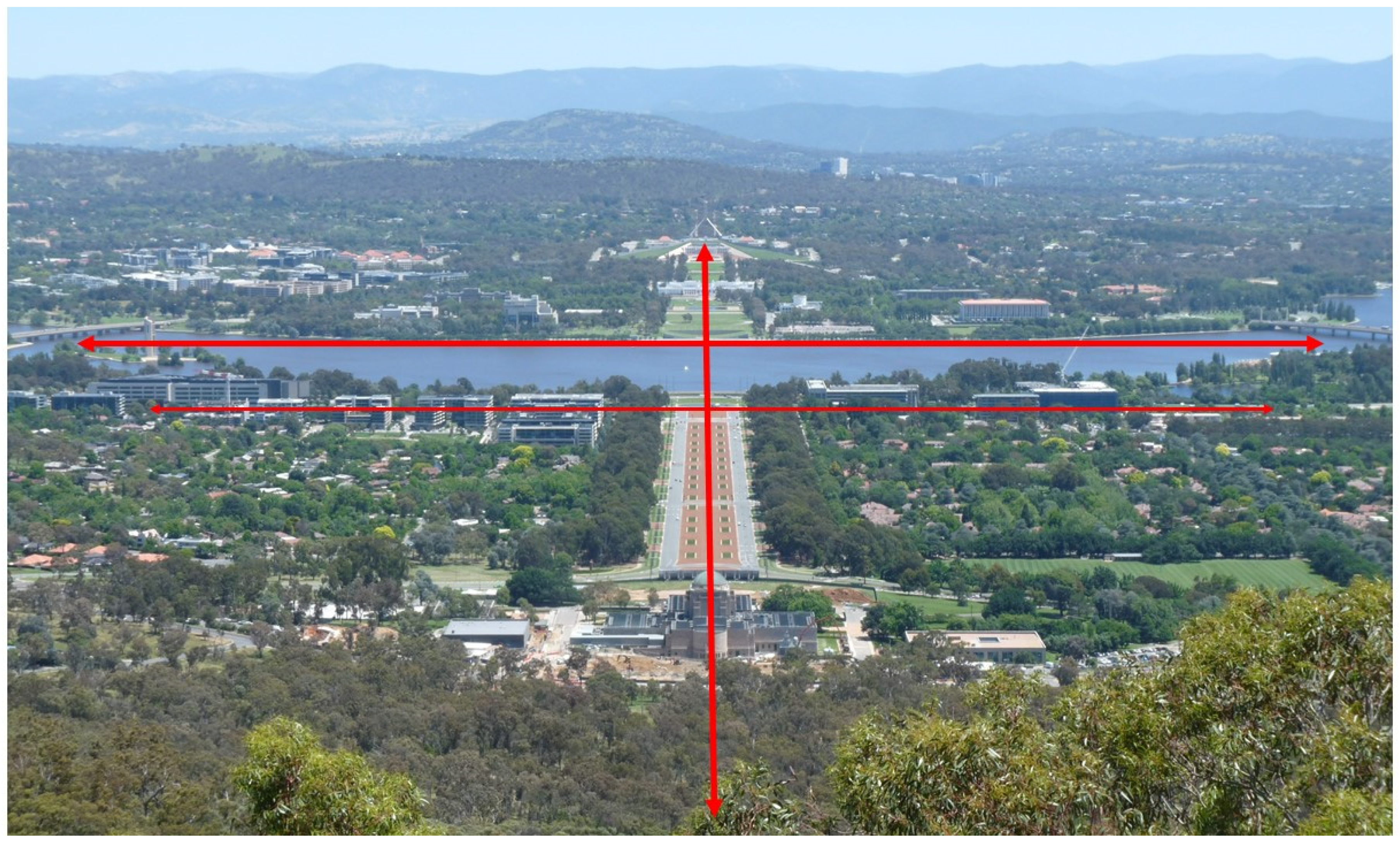
The selected design plan by Americans Walter Burley Griffin and Marion Mahony Griffin was greatly influenced by topographical and landscape considerations. Two symmetrical land and water axes aligned with four local mountain summits and crossed the city to link nationally significant building sites in conspicuous positions against the forested landscape as a backdrop (
Figure 1). The Griffins had not yet visited the site but their design encapsulated a vision of Canberra being a ‘city in the landscape’, nestled amongst forested hills and situated astride the impounded waterway of the Molonglo River with aesthetic formal water basins as a centrepiece (now Lake Burley Griffin) that also augmented humidity and equability. Griffin’s [
18] explanatory design report referred to ‘great garden and water vistas’, ‘connected park or garden frontage for all the important structures’, ‘common gardens, irregular hill garden subdivisions’, streets with ‘stately open-branched, broad-leaf evergreen avenue trees’, ‘quadruple rows and supplemental shrubbery parkways for shade and shelter, wind and dust arresting’ and ‘beneficial sunlight’. Public spaces, national monuments, boulevards, and architectural features reflected a focus on grandeur, aesthetics and a democratic purpose of ‘the greatest good for the greatest number’.
Incorporation of special views that reflect the local character and cultural context is a key consideration in defining a cultural landscape [
1]. This is achieved in Canberra by maintaining continuity with key original design elements of the landscape’s hills, ridges and valleys. More uniquely, the mixing of built infrastructure, natural infrastructure and plantings of stately exotic trees along with Australian native trees underlies the designation of the city as the Australian ‘Bush Capital’ [
19]. Regardless, its implementation and grandiosity was challenged early on by government officials and through disinterest from politicians and the public [
13,
15].
The importance and need for protection of the intent and symbolism of the original urban design legacy was recognised in 1964 by the Commonwealth Government [
20]. The ACT’s network of open space was formally conceptualised as Canberra’s National Capital Open Space System (NCOSS) and incorporated into planning regulation through the 1970s and 1980s [
20]. The NCOSS comprises the treed inner hills and ridges, the major (artificial) lakes and river corridors, and the views of mountains and bushland to the west of the city, with the region’s rural lands also part of the landscape setting. It now covers over two-thirds of the ACT [
17].
Despite the ACT gaining self-government in 1989, the NCOSS was retained under control of the Commonwealth Government and legislated as ‘designated land’ under the National Capital Plan (1990, 2012). This unique land tenure arrangement means that all land is owned by the Commonwealth Government and leased to landholders, thereby preventing uncontrolled private development [
21]. The National Capital Plan regulates development to preserve and enhance ‘landscape features that give the national Capital its character and setting’ while promoting local urban development that respects environmental values and sustainability [
20]. The Territory Plan is the key statutory planning framework for the ACT but cannot be inconsistent with the National Capital Plan.
Just over 100 years after its conception, and with its population and extent far exceeding the original design, careful planning continues to be essential to ensure the city’s liveability and the integrity of its vision for the next 100 years. Increasing pressure for urban densification, urban consolidation and high-rise buildings needs to be carefully managed to retain the open space, grandness, views of the surrounding hills and living infrastructure that are quintessential to Canberra’s historic urban landscape foundation and its nature–culture interface [
1,
19]. An additional new imperative is the need for urban climate change adaptation. Meanwhile, the connection to the landscape of Canberra’s First Nations people may be fundamental to achieving long-term biodiversity conservation and ecologically sustainable development.
4. Extent of Native Woodland, Ecosystem Values and Threats
At the time of European settlement, around one-third of the Territory was grassland or river flats with the remaining area comprising native forests and woodlands [
34]. Although woodlands were the dominant vegetation of the region, they now often persist only as small, degraded remnants. Only 25% (i.e., 11,568 ha) of the extent of the main class (Yellow Box–Apple Box Grassy Woodland) prior to 1750 (i.e., pre-European settlement) remains. In contrast, there is less than 2% of Natural Temperate Grassland but around 99% of valley Snow Gum Woodlands remaining [
41]. Although a substantial proportion (39%) of the remnant woodlands occur on lands managed by state government for conservation purposes, the majority (61%) are on rural lands, national land and other land managed primarily for other outcomes (
Table 1).
Despite the loss of woodland across south-eastern Australia, the ACT contains some of the most intact woodland remnants, which are exceptional in their size, connectivity, diversity and habitat for threatened species. Many woodland areas have been lost in urban expansion, but others have been incorporated into nature reserves [
36]. This includes significant remnants of the critically endangered Yellow Box–Blakely’s Red Gum (Box–Gum) Woodland, which has reduced from 23% to 9% in the ACT between 1750 and 2000. There are no intact woodland landscapes remaining in the ACT and the patchy remnants are highly variable in condition and depauperate in habitat features such as hollows, logs and litter, particularly in urban areas [
36]. Fortunately, the Territory’s leasehold system discouraged the pasture improvement techniques (i.e., ploughing, fertilising and sown pastures) adopted in eastern Australia from the 1950s, which adversely impact the distribution and abundance of native plants [
41].
Woodland trees are highly valued for landscape amenity and enhancing property values, leading to the retention of many large mature native trees within suburbs, parklands, road reserves, easements and on rural lands. Some local scattered Yellow Box (
Eucalyptus melliodora) trees have been dated to over 300 years old [
42]. Stands of trees and even isolated individual trees contribute to habitat connectivity for fauna, although the benefits are greater in larger stands and where the understory has been less modified by grazing [
28]. However, urbanisation has fragmented the woodlands and created sharp habitat boundaries at the edge of nature reserves. It also increased recreation that impacts on some threatened species and various woodland birds that are in decline [
36,
41].
Ongoing threats to woodlands include urbanisation, overgrazing, inappropriate fire, invasive species, climate change and dieback [
41]. Blakely’s Red Gum (
E. blakelyi) is particularly susceptible to dieback, but symptoms have been observed in eight
Eucalyptus species in the ACT [
43,
44].
E. blakelyi is a dominant canopy species in Box–Gum Woodland. The species is at the limit of its thermal range in the ACT and vulnerable under the increasingly warm climate and increasingly consecutive years of stressful precipitation conditions during the growth season, based on 1940–2017 data [
43]. Its decline has major implications for the viability of environmental offsets, created under national legislation to compensate for development impacts on this threatened ecosystem, and also because of the risk to the threatened Superb Parrot (
Polytelis swainsonii) and other threatened birds that nest in
E. blakelyi hollows. New plantings do not compensate for the ongoing loss of many mature and over-mature trees or tree hollows, which take over a century to form [
14,
44].
An evaluation of changes in urban mature trees between 2004 and 2015 showed that suburban development initially causes a marked decrease in mature tree canopy cover, presumably largely of native trees, although with gains of younger and possibly primarily non-native tree species in gardens and road verges (
Table 2). Canopy cover was analysed by the ACT Government using 2004 SPOT-5 satellite imagery and 2015 LiDAR (Light Detection and Ranging) aerial-imaging data for several early established suburbs, recently established suburbs, nature reserves and rural areas of the ACT [
45]. Notable was the considerable gain of tree cover and number in most of the analysed rural areas and nature reserves. This may be due partly to environmental plantings as well as reduced livestock impacts on regeneration. It would be valuable to assess in more detail the relative gain and loss of native trees across the tenure types, and particularly of mature native trees. Detailed ground surveys and mapping are needed to distinguish native from exotic trees, but the mapping provides a robust baseline for future analyses of tree cover change.
5. Current Programs and Initiatives
A range of policy and legislative mechanisms direct environmental outcomes in the ACT at a state level while Commonwealth Government imperatives provide planning controls over Commonwealth land (e.g., designated land and defence land) within the ACT. The key mechanisms relevant to tree conservation and protection encompass statutory planning, biodiversity conservation, cultural heritage conservation and climate change impact mitigation (
Table 3). Importantly, the ACT Planning Strategy continues the vision of Canberra being a city within the landscape that celebrates its bushland setting [
14].
The key ACT policies with specific tree-related targets or a focus on forest condition and biodiversity outcomes are the Nature Conservation Strategy, the Urban Forest Strategy and the Living Infrastructure Plan. Collectively, these policies aim to conserve the city’s landscape and biodiversity, address key threatening processes such as the loss of mature native trees, address urban heat and urban sprawl, and engage the community in recreational use, appreciation, growth and maintenance of living infrastructure. Similarly, the National Capital Authority drafted a Tree Management Policy in 2021 to ensure that landscape maintenance plans on Commonwealth-controlled land integrate tree and heritage management planning for the national benefit.
Considerable work is occurring towards these aims and achieving sustainable development outcomes. It includes (i) regulatory update, (ii) inventory, (iii) mapping, (iv) asset valuation and management, (v) research and (vi) stakeholder engagement.
5.1. Regulatory Renewal
A review and reform through 2019–2022 of the ACT’s planning system will lead to revised planning legislation, a new Territory Plan and new district strategies that determine the city’s development and the government’s aspirations for its growth. The intended outcomes are to deliver a liveable, sustainable, resilient and diverse Territory for future generations.
In parallel, a review and update of the ACT’s
Tree Protection Act 2005 is underway. This will increase focus on tree protection and conservation issues (e.g., tree habitat values) rather than the current emphasis on regulating removal [
14]. The new Urban Forest Bill will work alongside a draft variation to the Territory Plan (DV369) to increase protection on leased land for existing canopy trees including safe mature native trees, while making room for trees during development and ensuring that canopy trees approved for removal are replaced with new plantings. The draft variation proposes higher requirements for minimum planting area, along with new requirements for plantings. The Living Infrastructure Plan aims to increase tree canopy cover (or equivalent) to 30% and ground-surface permeability to 30% across the urban area by 2045. Urban canopy cover is on track towards the target, being estimated as 22.5% in 2020. The extent of permeable surfaces in urban Canberra has been estimated as 42%, already exceeding the target at a large-scale; however, issues with stormwater flooding, waterway pollution and altered hydrology in reserves near urban development show that further research and finer-scale assessment is needed to reduce these impacts.
The Urban Forest Bill assists in landscape protection by encouraging brownfield rather than greenfield development through a 70% urban infill target. In addition, an action plan has been prepared to address the loss of mature native trees (including hollow-bearing trees). Lack of recruitment has been recognised as a key threatening process under the Nature Conservation Act 2014 with impacts on at least four threatened birds. The action plan aims to protect existing mature native trees, increase recruitment and survival of young native trees, and enhance the ecological context of mature and young native trees.
5.2. Inventory
Identification of natural assets such as mature native trees, regulated and registered trees, and culturally significant trees is essential to guide onground management and prevent inadvertent damage and loss. On land managed by Transport Canberra and City Services, an asset management system is expanding to include public urban trees. Similarly, the Environment, Planning and Sustainable Development Directorate is developing spatial databases and asset systems for recording values including significant trees in the nature reserve and national park estate. There are now an estimated 770,000 trees on leasehold land in Canberra and a similar number on public land.
A cultural heritage database is also being developed, but conversations are needed about how best to manage intangible as well as tangible heritage. For example, conservation of some trees of significance to the Ngunawal Traditional Custodians requires that line of sight be maintained between the tree and other landscape features [
46].
5.3. Mapping
SPOT-5 satellite imagery and LiDAR aerial-imaging data are being used to develop a tree canopy coverage and canopy height model for the ACT. The identification and mapping of mature and remnant native trees will assist with native tree protection in urban areas under the Urban Forest Strategy. The 2020 LiDAR data are being used to track progress towards the 30% urban canopy cover target.
The LiDAR data also provided underpinning evidence to the ACT Scientific Committee about the loss of mature native trees across the Territory, which assisted in the listing of the Loss of Mature Native trees as a Key Threatening Process under the Nature Conservation Act. Studies of dieback in the critically endangered Box–Gum Woodland across the Territory also drew on LiDAR imagery from 2004 to 2017 and were able to establish measurable changes in woodland condition through time [
43,
47]. These analyses will be revisited with later data to better understand dieback trends and risks to offsets with susceptible
Eucalyptus species.
5.4. Asset Valuation and Management
More broadly, the use of environmental economic accounting is being explored in the ACT as a tool to analyse development issues, assess policy options and promote decision making that incorporates the stocks and flows of environmental assets and the consequential benefits and beneficiaries of those flows. Preliminary work has been undertaken on water accounts and for state of environment reporting, and is proposed for biodiversity assets in an urban development context.
The ACT’s target for increased urban canopy cover aims to assist with mitigating local impacts of climate change. Discussions are ongoing about canopy cover equivalence such that other green/blue infrastructure (e.g., green rooves, shrub beds, wetlands and rain gardens) could contribute to achieving this target. A key challenge is to match site and landscape context to appropriate species form, and leaf characteristics to the climatic imperative; for example, deciduous non-native trees in sites needing summer shade also reduce air temperatures, local native species enhance habitat connectivity to reserves, and native groundcover plants beneath native trees in suburban parks support tree condition but also reduce maintenance costs. The choice between native and non-native trees is not clear-cut; shade from some deciduous trees can reduce air temperatures up to 15 °C on hot days but the trees may not be drought and heatwave resistant [
48].
The ACT Government works with key stakeholders and the community to retain as many trees as possible. The Canberra Tree Network brings together ACT and national government staff with representatives from neighbouring councils, universities, the government nursery, Parliament House, the National Botanic Gardens and the National Arboretum to share information about programs and Tree Week activities. Within the urban leasehold land context, the Government has trained staff to create hollows in standing dead trees to alleviate the loss of these features from development. Nevertheless, in 2018/19, 1731 tree removal applications were approved from 2320 submissions.
5.5. Research
A Tree Canopy Equivalence Tool and methodology was developed to calculate the equivalence of alternate blue/green infrastructure to trees and shrubs of over 3 m height. This research built on the mapping of other living infrastructure types to quantify the benefits and equivalence of ten disparate forms of living infrastructure. However, the results were constrained due to limited input data. Importantly, such a tool may cause perverse policy outcomes such as where exotic lawn with a high level of equivalence may overwhelm the tree canopy target. It is critically important that the environmental (and socio-cultural) benefits of native species are maximized wherever possible given their overall decline and the threatened status of some native species and ecosystems.
Similarly, the social and heritage benefits of exotic trees in the urban context need to be considered in light of their impact on native ecosystems. For example, many of Canberra’s waterways have water quality problems and the LiDAR-derived maps of urban tree cover density can be used to assess leaf litter deposition and the associated adverse impacts of nutrient loads on waterways.
The mapping of mature native trees will be used as part of critical habitat identification and mapping for hollow-dependent threatened bird species such as the Superb Parrot and Gang-Gang Cockatoo (Callocephalon fimbriatum). Research on the ecology and flight paths of these species using GPS trackers on birds will assist in understanding the importance of particular trees in the landscape. When incorporated with climate change projections, these data can inform where habitat supplementation (e.g., tree plantings, created hollows and provision of nest boxes) and additional conservation to ensure landscape-scale habitat connectivity are needed. Experimental research on the benefits of dead mature trees has led to their increased retention and the reinstatement of some that were removed from urban development sites into offset reserve areas.
5.6. Stakeholder Engagement
Given the losses of mature trees across the urban area, planting is an essential component of achieving the 30% tree canopy cover target. The ACT Government is planting 54,000 trees between 2020 and 2024. It provides support to three catchment coordination groups for ecosystem restoration and offers grants to over 60 community groups and stakeholders through environment grants and ‘nature in the city’ grants. Community representatives are able to discuss concerns and government planning through a Biodiversity Conservation Forum initiated in 2021. National government funding is also contributing to protecting and connecting endangered woodlands.
Demonstration sites and information dissemination contribute to an informed population. The Whitlam Display Village is trialing innovative living infrastructure solutions including passive irrigation, permeable driveway surfaces and street tree planting. A Climate-wise Landscape Guide is being prepared to assist developers and homeowners create climate-wise landscapes, while government-commissioned research informed publicly available standards identifying trees that are suitable in a climate change context.
One community-led project in late-2019 transformed a small urban ‘pocket’ park in south-western Canberra. The park is a remnant of Box–Gum Woodland with several 200–300 year old trees. Its landscape location suggests that it was a damp biodiverse woodland gully prior to European settlement. However, heavy infestation with invasive exotic grasses (African Lovegrass Eragrostis curvula, Chilean Needle Grass Nassella neesiana) led an influential government advisor to consider the site too degraded to warrant restoration.
Nevertheless, the local community persisted and received a small AU$12,500 government grant. They used the funds to manually remove invasive grasses, solarise soil to kill the weed seedbank, and create wide, shallow berms and swales around contours using treated soil to slow water movement and increase water retention on site. An excavator was brought in to experiment with methods for weed seedbank removal and reducing soil compaction to increase plant rooting depth. A rock flume was created to redirect stormwater from upslope impermeable surfaces (i.e., roads and footpaths) into the park as an ephemeral creek with plantings of native groundcover species to filter pollutants.
The revegetation focused on restoration of the structure and composition of the original understory of the woodland, changing the soil nutrient status to favour native rather than exotic plants, and repairing hydrological function. Planting of rows of native sedges within the dripline of old native trees created a pedestrian barrier and an area for retention of fallen timber, which is perceived as a risk by some members of the community. The actual risk of harm due to tree failure in Canberra is very low, around 1 in 15,000,000 deaths due to accidental tree failure and 1 in 189,000,000 deaths inside a house from tree failure, compared to 1 in 20,000 from driving and 1 in 13,500 from melanoma [
49]. However, responding to this health and safety issue alleviated local concerns. After only two years, there is an increased number of native butterflies and birds on site and native shrub and tree seedlings emerging from the remnant soil-stored seedbank; meanwhile, invasive grasses are very limited in treated areas.
The overarching intention was to develop a method that could be applied in other parks. The project initiator trialed research and novel restoration methods in keeping with the urban context and the social and economic limitations of urban sites. This included how the community used the area, the presence of underground and above-ground utilities, and the need for cost-effective maintenance. The community responded by volunteering their time and labour to the project and ongoing maintenance because they understood its value. This created greater neighbourhood connection, ownership of the project and interest in the site with residents reporting noticeable cooling effects and mental health benefits. ‘Cues to care’ were used, including signage, flowering plants and patterns of mown grassed walkways, which signal intentional human maintenance and valuing of the site [
50]. They create opportunities for challenging a culturally aesthetic paradigm of manicured trees with a mown grass understory. In providing something familiar and recognisable, they allow people to learn to value the unfamiliar beauty and function of complex habitat structures.
The project highlights the importance of community engagement, education and directly addressing the costs and externalities of suboptimal practices. Constant mowing damages hydrological processes, is costly, and unsanitized equipment has spread ecologically transforming weeds [
14]. Meanwhile, risk-averse perspectives about accidental tree failure contributed to the removal of many mature and hollow-bearing trees [
14]. Championing alternative approaches focused on restoring ecological function provided cost-effective social and biodiversity conservation outcomes.
6. Discussion and Conclusions
Human agency and relationships with the environment of the Canberra region are inherent, essential elements in its changing landscape from pre-European to present times. By focusing on treed ecosystems, we can understand the city and its landscape as an evolving process of interactions between nature and culture, tangible and intangible heritage, that have created the special character or genius loci of the city [
1]. Canberra is a uniquely planned, idealized city [
1,
18] in a landscape with an active human presence of at least 25,000 years, a landscape that represents a palimpsest with an archive of messages about the past [
26]. Deliberative engagement with this landscape has been a primary influence at a diffuse level for thousands of years and at a documented intensive level for just over 100 years. Through the four temporal phases described here for the Canberra region, there have been various indicators of these culture–nature relationships, some of which are common amongst the phases.
Firstly, the tree-dominated ecosystems have been altered substantially by people, for tangible and intangible outcomes. Early settlers extensively cleared local woodlands to enhance areas for stock grazing and utilized timber resources for fencing and housing. Most of the trees that they planted were familiar European species, reminiscent of their origins and in keeping with colonial planting preferences. Later, city planners, officials and residents introduced extensive numbers and types of tree species to enhance landscape aesthetics and provide shelterbelts, greenways, urban parks and gardens for environmental and recreational purposes. Many of these trees also were European or North American species, particularly in formalized plantings. Despite some early interest in the horticultural use of local native plants, it was not until the 1970–1980s that they dominated some suburban and iconic area plantings in the Parliamentary zone. The First Nations people, the Ngunawal, also manipulated local forests through deliberate use of fire to enhance utilitarian needs, such as food and material resources, and create accessible pathways across the landscape. Some trees also held intangible values for Ngunawal people; for example, signifying connections between culturally significant landscape features.
A second indicator of this cultural landscape is in the various, often overlapping ways in which people have related to elemental features: topography, ecotones and sunlight. Major topographical features including mountains were named by Ngunawal people and many had ceremonial or spiritual importance [
26]; for example, Mt Ainslie is a culturally significant women’s place for Ngunawal women and Black Mountain is a culturally significant men’s place for Ngunawal men. The mountains, hills and ridges also were intrinsic elements of Griffin’s design for the cityscape. Similarly, waterways represented pathways for Ngunawal people with many culturally important sites nearby, and were the first areas to be settled by Europeans. Ecotones such as land and water junctions were richest in resources [
26,
27]. Moreover, the lake formed from damming of the Molonglo River shows this temporal continuity of the importance of the water–land interface—it was the centrepiece of the city’s design and is now a major recreational, aesthetic, social and touristic resource, with increasing multi-storey residential developments adjacent. Another aspect of this theme is sunlight, which is explicitly accounted for in Griffin’s municipal planning but also important traditionally to Ngunawal people. Ngunawal sites occur across the landscape and Kabaila [
26] considered that their only predictable characteristics are that campsites are likely to occur on gentle slopes with a north-western to north-eastern aspect, thereby maximising sunlight.
Thirdly, Canberra is the seat of government but the site of Parliament House was also a major meeting place for multiple Aboriginal language groups. Likewise, there are other monuments or important infrastructure now located on sites that were significant to Ngunawal people (e.g., the Botanic Gardens is on a former corroboree ground and a nearby university oval was a hunting ground [
31]). An overlay of human movement has also occurred, with Ngunawal pathways being used by stockmen and explorers, and many later being converted to European roadways [
26].
This rich history of human engagement and overlays of inter-relationships with, and modifications of, the local landscape reflect an evolution of social values, needs and ecological connections that have sustained people in different but similar ways. The nature–culture connection has become embedded throughout the city’s parks and open space as a consequence of considered legislation and design planning [
14,
21,
34]. Yet, ongoing population growth, suburban expansion, urban densification, resource demands, biodiversity loss and climate change are imposing considerable pressures on the bushland and grasslands, landscape setting and connectivity of ecosystems. Some argue that recent governments have compromised the landscape, sustainable planning outcomes and the original design philosophy in preference for economically oriented objectives including job growth and urban densification (e.g., [
14,
17,
19,
26]). Since self-government in 1988, new suburbs have largely comprised small urban plots dominated by large houses with little green space, mature trees, soil permeability or native species habitat, and high-rise buildings, without regard for the historic landscape [
1,
26].
While densification and consolidation do reduce pressure on the city’s surrounding natural environment, they challenge the feasibility of protecting adequate natural landscape, biodiversity values and native species’ habitat corridors throughout the cityscape as well as the landscape and the cultural heritage that is intrinsic to its character [
1]. Biodiversity and cultural heritage conservation are underlain by national and state-level policy and legislation. However, it is recognised that maintaining the current density of urban development (i.e., 1080 residents per km
2) for a projected population even of 600,000 in 2041 is ecologically unsustainable, inefficient with regard to sustainable transport, and increases pressures on agricultural land and environmentally sensitive areas [
12]. Additionally, the population is highly transient and around half of the population growth is from overseas migration, and thus, inhabitants are potentially unfamiliar with local landscape values. Nevertheless, the high proportion and usage of Canberra’s urban reserves, the latter particularly notable during the COVID-19 pandemic, as well as a high level of community volunteerism and restoration initiatives and government policies and programs (see [
14]) demonstrate a growing willingness and commitment to experience and retain the city’s landscape character and natural values.
Achieving biodiversity and cultural heritage conservation is dependent on collective, collaborative efforts across government, stakeholders and the community. Some of the planning mechanisms relate to ACT and some to Commonwealth objectives, and because there are multiple agencies within ACT Government with primary responsibility for these mechanisms, there is a need for deliberative review and integration to facilitate optimal outcomes across the breadth of intended approaches and complementarity of actions. Even within ACT Government, trees within a reserve and national park context are managed by the Environment, Planning and Sustainable Development Directorate whereas trees within an urban context are managed by Transport Canberra and City Services unless the trees are on national land, where they are managed by the National Capital Authority. The defence estate is managed separately again. Issues around infrastructure maintenance (e.g., pipes, electricity and telecommunications cables) also draw in the perspectives of utility organisations [
14]. Coordination, communication and transparency across agencies, government advisory and scientific committees, and research partners are, therefore, critical to effective outcomes-based decision making, as is commitment to best-practice approaches, long-term outcomes and maintenance of the urban forest and its natural and cultural values [
14].
Community engagement and stewardship in valuing, growing and maintaining the city’s vegetation is another key aspect to achieving optimal biodiversity as well as social and economic outcomes. As demonstrated in the pocket park restoration example, community leadership can result in novel or experimental approaches that achieve unexpectedly good outcomes including a sense of community empowerment and connection [
14]. Although a ‘small win’, strategic planning for community stewardship could be part of transformative macro-level changes towards sustainability [
7]. Strong interest in the urban forest is already evident through a citizen’s forum in 2018 that ranked street and park trees as the second highest priority among 14 municipal services [
14]. The government policy intent is for all residents to have access to nature within a kilometre of their home in recognition of the benefits for health and wellbeing, as well as the social and economic benefits. This is supported by research from Japan showing the linkage between local green spaces and longer life expectancy [
14]. However, it is paramount to address quality as well as quantity of green space [
14], particularly as urban infill progresses.
The intangible associative values now valued by many Canberran residents are a key part of a cultural landscape but also central to the deep relationship between First Nations people and their Country (landscape) [
1]. The relationship of people and natural elements is part of the identity of a place and an inclusive sense of belonging, which can be experienced such as for tourism purposes but can also inspire people’s attachment and desire to live in a place or as part of a community [
1]. As a young city of just over 100 years old, with a populace that is highly transitory and dominated by people born elsewhere, there is a need to build a sense of connection to the city and landscape amongst Canberra’s residents. In this, there is a clear opportunity to engage at a deeper level with a traditional Ngunawal perspective that emphasises personal experience and perception grounded in the inseparability of mind, body and environment [
37]. Incorporation of an ecosystem approach, long-term intergenerational outcomes and First Nations peoples’ cultural rights are embedded within our international biodiversity conservation frameworks. It may be that this custodial approach, focused on stewardship of natural and cultural values, is the missing ingredient in ensuring the city’s ecological sustainability and long-term biodiversity conservation outcomes. An integrative policy could be developed for the Territory that acknowledges the nature–culture connections across urban and non-urban spaces, and clarifies the past, present and future needs and values of people in the landscape and how to best achieve them.
In conclusion, deliberative planning has been foundational in creating an exemplary city of global significance designed to integrate the natural values of the landscape’s hills, ridges and valleys with the city’s design, built infrastructure, cultural intentions, aesthetics and societal outcomes. This review demonstrates the considerable interface between culture and nature through human agency on landscape elements, and specifically the intentional modification of treed ecosystems for particular objectives. Through time, there have been differential relationships of people to the landscape including the importance of natural values. Strong visionary leadership is now imperative to reconcile the current diversity of visions and approaches. A landscape-level policy could optimise outcomes by embedding an ecological and Ngunawal sensibility in future planning. The heritage values can be respected while protecting the natural and cultural values that designate the city as the nation’s Bush Capital and influenced Canberra being identified by the OECD in 2014 to 2020 as the world’s most liveable region [
51] based on 11 indicators of wellbeing, including life satisfaction and environment. Key challenges relate to progressing an innovative, integrated approach that encompasses all natural and green spaces in the Territory, their values, and their socio-cultural importance. Imperative in this is coordination and engagement across all relevant groups with interests and responsibilities in particular locations, and building connection amongst all residents to the city’s landscape and values. Nature and culture need to be deeply understood to be well managed [
14] (p. 67), the facilitation of which goes beyond passive education and engagement, towards engendering a stewardship ethic and attachment to a place (or city) and its landscape.


