Article

Evolving Cultural and Historical Landscapes of Northwestern Colchis during the Medieval Period: Physical Environment and Urban Decline Causes

1
Institute of Archaeology of the Russian Academy of Sciences, 117292 Moscow, Russia
2
Federal Research Centre the Subtropical Scientific Centre of the Russian Academy of Sciences, 354002 Sochi, Russia
3
Institute of Geography of the Russian Academy of Sciences, 119017 Moscow, Russia
4
N.N. Semenov Federal Research Center of Chemical Physics of the Russian Academy of Sciences, 119334 Moscow, Russia
*
Author to whom correspondence should be addressed.
Land 2022, 11(12), 2202; https://doi.org/10.3390/land11122202
Submission received: 23 October 2022 / Revised: 30 November 2022 / Accepted: 1 December 2022 / Published: 4 December 2022
(This article belongs to the Special Issue Historical Landscape Evolution)

Abstract

:
In Late Antiquity and the Early Middle Ages, both coastal and sub-mountainous parts of Colchis underwent rapid urbanization. In the 12th century, the processes of decline began: Large settlements were replaced by small farmsteads with light wooden buildings, and the economy transformed from commodity-based to subsistence-based. What caused this decline? Was it the social and political events linked to the decline of the Byzantine Empire and changes to world trade routes, or were there other reasons? This article provides the answer. The synergy of archaeological, folkloristic, historical cartographic, climatological, seismological, and hydrological data depicts a strong link between these processes and climate change, which occurred at the turn of the 12th–13th centuries. The beginning of cooling led to a crisis in agriculture. A decline in both farming and cattle breeding could not fail to affect demography. Seismic activity, noted in the same period, led to the destruction of many buildings, including temples, and fortresses, and changes in hydrological networks, which were directly linked to climate change and caused water logging, led to a loss of the functions of coastal areas and their disappearance.

1. Introduction

Northwestern Colchis is partly located in the present-day Russian Federation (Greater Sochi Area, Krasnodar Region) and the Republic of Abkhazia. Nevertheless, from ancient times to the end of the 20th century, Colchis was a single historical and cultural area (Figure 1). Throughout history, this area was of major importance for various cultural interactions, and in Late Antiquity and the early Middle Ages, the area experienced urban growth and transformation of the settlement structure, resulting in the temple stone architecture marking densely populated areas. Ancient towns and settlements in the area have been insufficiently studied by archaeologists because the buildings were traditionally constructed from sun-dried brick, hiding such structures in the landscape. However, analysis of the temple size and the distribution of the temples gives a clear idea of demographic processes. Other important markers are the remains of stone fortresses, which reveal the main caravan routes connecting the Caucasus Range mountains and coastal trading posts. Thus, archaeological evidence depicts vivid signs of the rise of urbanization, both in the coastal part and in the mountainous areas during the period of Late Antiquity and the early Middle Ages. By the 12th century, archaeological findings confirm that the process was reversed, and settlements fell into disrepair. During this process, temples collapsed, and large settlements with stone buildings were replaced by small farmsteads with light wooden buildings [1]. What brought about the decline? Several factors may have been involved, including social and political events associated with the decline of the Byzantine Empire and changes in world trade routes, as well as other causes of a global or local nature. The impact of climatic factors on the level of socioeconomic development in society during the entire period of mankind can be traced clearly enough [2,3,4,5,6,7]. This article presents a synthesis of archaeological and paleogeographic data showing the effects of climatic, hydrogeological, and seismic factors on the development of settlement structure, together representing an attempt to recreate the historical period being analyzed.

2. Materials and Methods

The main research method in this study is a comprehensive analysis of the settlement structure in GIS, applying relevant data from other natural science disciplines.
Geo-information systems have been a traditional research tool for many years, not only in geographical but also in historical research around the world [8,9,10,11,12,13,14,15,16]. Our team has performed field research since 2001 [17] to find the sites of northwestern Colchis, and currently the database includes 1780 sites, including dolmens, temples, fortresses, settlements, individual sites, and burial grounds, without any architectural remains above the surface. Data on the location of the object, submitted as geographical coordinates, were recorded using GPS.
The archaeological data set was presented in the form of point objects together with an associated primary database containing the following key positions:
  • Title
  • Type of site
  • Ancient (antique or local) toponym (if any)
  • Link to reference in written sources (if available)
  • Names of researchers of the site (if available)
  • Years of research of the site (if available)
  • Description of the site
  • Bibliography (if available)
  • Level of preservation
  • Modern use of the territory
  • Area (if defined)
  • Dating
  • Interpretation
Due to certain objective reasons, i.e., different states of preservation and the study of sites, the primary database is being constantly updated and modified correspondingly by applying layering and hyperlinks. Via hyperlinks, raster and media data are connected to point objects, including plans, photographs, and 3D models. As object data in point-layers format do not carry complete information about the location of the site and its outline in the landscape, the GIS is supplemented with polygonal data obtained from orthophotomaps and digital terrain models (DTM) of sites included in the GIS [18].
The study of temples is crucial for the analysis of settlement structures in the periods of Late Antiquity and the Middle Ages. According to W. Christaller [19], temples are regarded as “central places”, each representing a type of political and administrative center. Temples, therefore, mark not merely the direct spread of Christian religion but also the administrative and political division of the territory. Moreover, taking into account the size of churches, which depended on the number of parishioners, it is possible to estimate the demographic situation in the area in order to trace the dynamics of population settlements based on different terrain altitudes, to identify the most favorable geographic zones in each chronological period.
A critical issue for the reconstruction of settlement structure is dating. The vast majority of temples have not been studied and cannot be allocated to a certain period. However, prior assumptions about dating can be made based on several factors:
(1)
A detailed description of the architectural features of temples, followed by finding similarities to certain architectural details and features between a number of temples. Recording the frequency of the occurrence of such features in the studied area enables one to obtain the required data to date and characterize different architectural schools [20];
(2)
Analysis of mortar in the masonry of the site [21];
(3)
Analysis of lifting materials, including plinthite analysis [22];
(4)
Data obtained during excavation works.
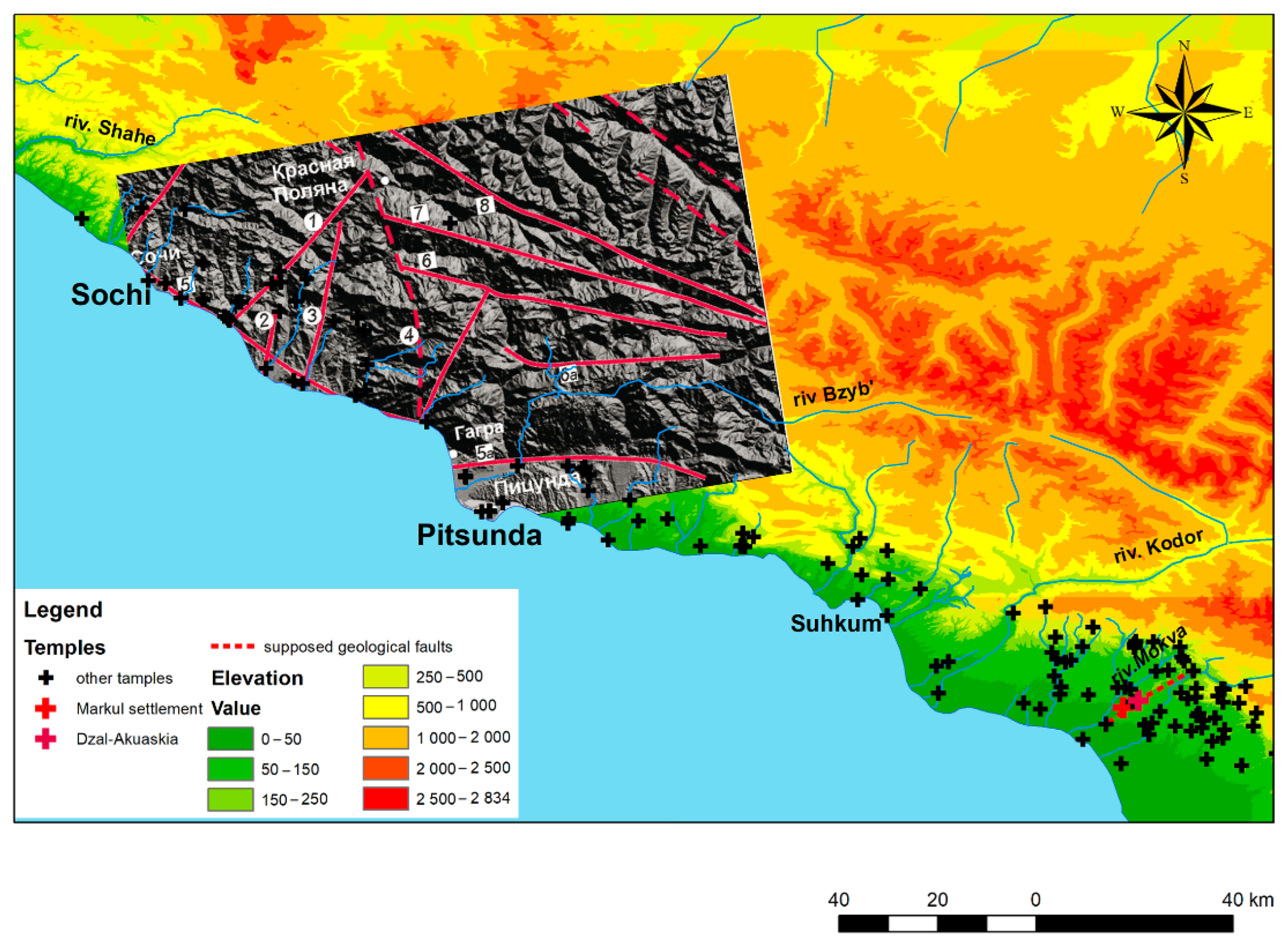
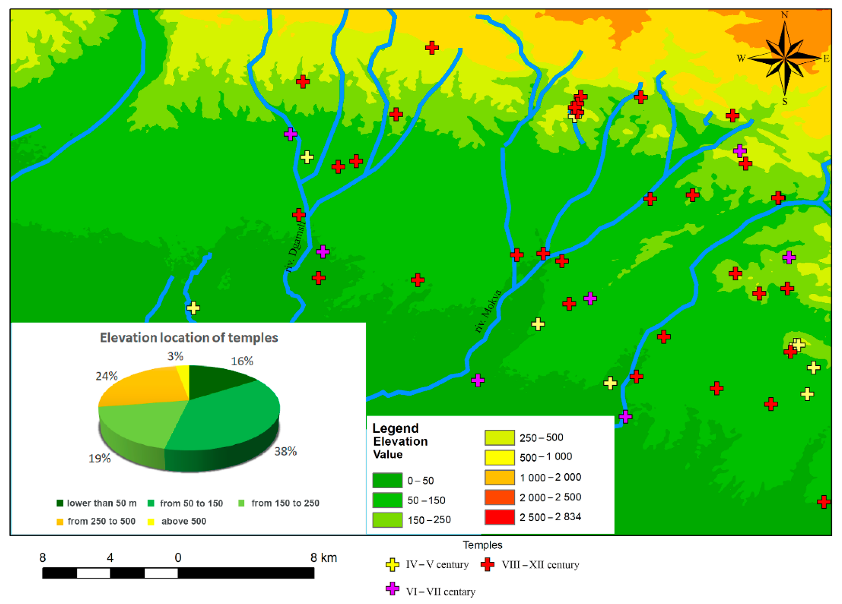
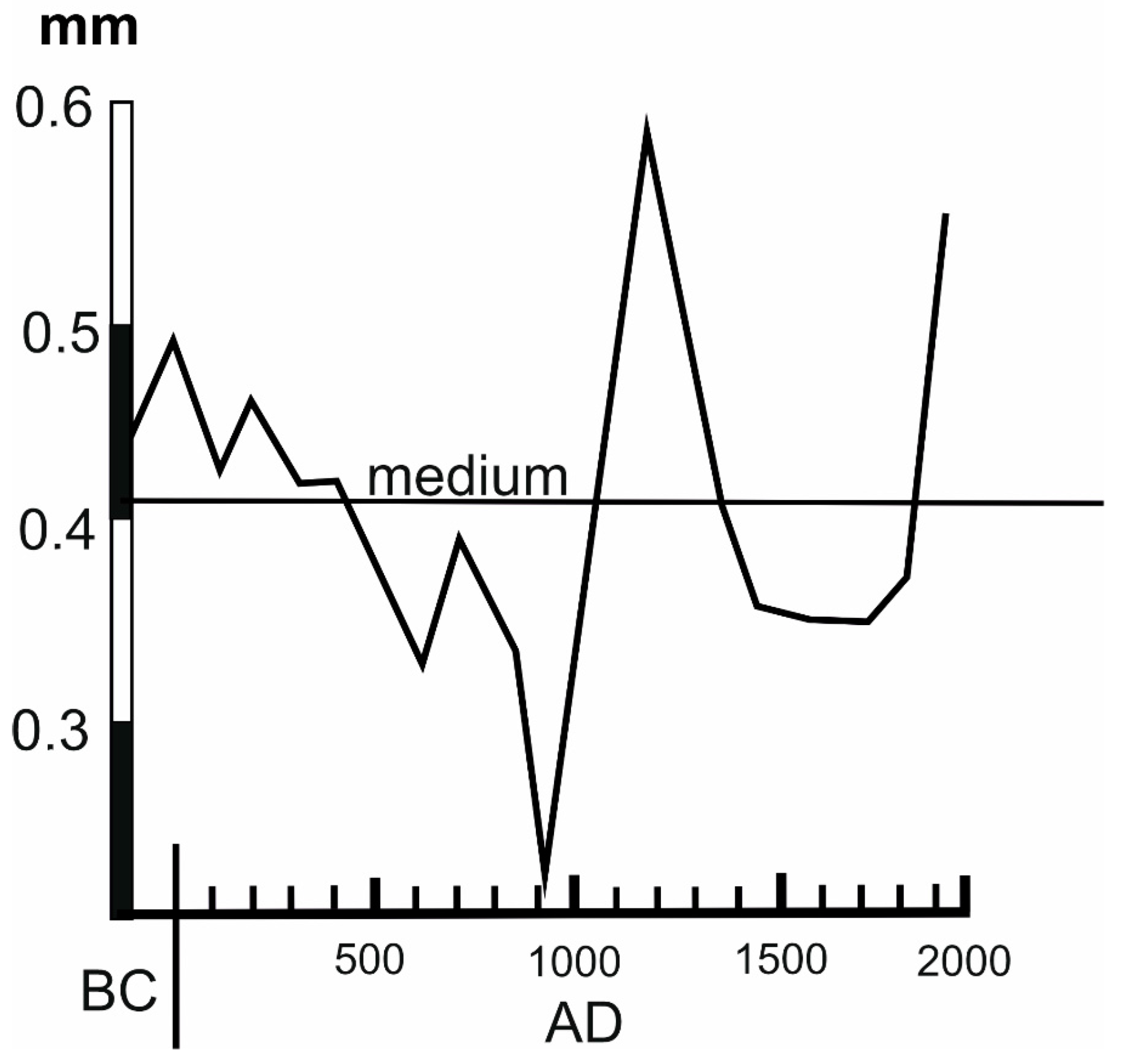
Therefore, dating is based on an integrated approach that involves the organization of archaeological surveys, work with archival data and literature, analysis of architectural features, and the use of natural science methods. Simultaneously, it is important to find two main dates: the date of construction of the temple (Figure 2) and the date that the temple ceased to function (Figure 3).
It should be noted that the former date is generally more accurate than the latter since it is very problematic to identify and precisely determine the date that a temple ceased to function. However, in some cases, it remains possible to acquire such a date. Excavation and narrative data represented by chronicles and church literature, with references to existing temples and monasteries, Genoese portals, where certain sites are marked, and maps from the modern era, can be used to confirm the date that a temple ceases to function; meanwhile, reference to the temple may indicate its functioning during a certain period. For example, by analyzing travelers’ descriptions and finding reference to ‘ruins’, one can assume that the temple had ceased to function by the time of that evidence. However, for certain sites, a simplified method must be used: interpolation. In this scenario, if a temple in the village Vesyoloe was ruined by an earthquake [23], and next to it (in about 3 km), the ruins of another temple (“Sovkhoz Russia”) were found, then it can be assumed that the reason for the destruction of both temples was undoubtedly the same. Thus, under various assumptions, we can obtain maps of temples for various chronological periods in addition to graphs of the dynamics of the building of temples and their destruction (Figure 2 and Figure 3).
Another important aspect relates to data on hydrographic networks, including rivers, reservoirs (lagoons and lakes), and changes in coastline development. Notably, direct research was not conducted by the present authors; all of the information was borrowed from the research of hydrologists and palaeogeographers published in the second half of the 20th century, since modern studies in this area have not been carried out in the territory of the region of interest [24,25,26,27,28]. Data from the literature were entered into the existing GIS, partly by overlaying various layers of maps presented in the literature and geocoding based on reference points, i.e., recording a river’s shoreline or lines of the road and other objects easily distinguishable in the landscape.
Climate curves represented the next set of data. For this area, data could only be found in the works of Soviet scientists [29].
Maps of tectonic faults and seismic zones were the most crucial layer in GIS. These materials are well-represented in the works of modern researchers of the 21st century [30,31,32]. It should be noted though that the available data refer only to the northwestern part of the area. Comprehensive studies on the area east of the city of Sukhum have not been carried out. The findings of our archaeological team revealed evidence of earthquakes and landslides on archaeological sites in the Ochamchira region of the Republic of Abkhazia, in the Mokva River basin (Figure 4).
Seismic zones, in contrast to climatic and hydrographic ones, are not usually taken into account in archeology. Studies related to the influence of the physical environment on human evolution usually focus on climate as the main external driving force of evolution and cultural changes. However, recently, the attention of archaeologists has increasingly focused on the effects of tectonic factors, including theoretical works [33,34,35,36] and research on the impacts of those factors on individual sites, e.g., in the European Bosporus (Crimea Peninsula) [37], Greece [38,39,40,41,42], Turkey [43], Jordan [44], and many other parts of the globe [45,46,47,48,49]. However, no similar investigation in northwest Colchis has yet been conducted. Meanwhile, these factors are crucial for the analysis of all settlement structures since archeologists must detect evidence for the occurrence of tectonic factors. Therefore, the available maps of tectonic fault zones were included as a separate layer in the GIS to determine the number of sites within areas of high seismic activity. Only a minor portion of sites (no more than 10%) have been thoroughly studied. Nevertheless, by knowing about those zones, we can determine the areas where settlements (and, accordingly, traces of their architectural structures) could have been destroyed due to seismic factors. For the parts of the territory where no seismic maps are available, we can obtain information about the traces of earthquakes after archaeological research and then add these zones to the areas of high seismic activity (Figure 5).
The following GIS analytical functions were used: Thiessen (or Voronoi) Map and Distance Cost Weighted. Thiessen (or Voronoi) Map functions of GIS analytical tools made it possible to determine the areas that belonged to a particular temple as “central places”. The adjustment of polygons, taking into account hydro networks, was performed in manual mode. Distance Cost Weighted was used to reconstruct the road networks and, on the basis of these, temple clusters were identified. The DEM used to create the cost raster was obtained from the open source ASTER Global Digital Elevation Map. Standard tools of ArcGis such as map overlay, selection, data sorting, and others were used.
Another important source of information, not directly included in the GIS, is folklore. Folklore is a traditional source for historical research. In the local people’s memory, events of the distant past are preserved, transformed, and then reflected in legends. For example, the Nart saga mentions “climatic cataclysms”, containing lines about cold weather: “One year heavy, deep snow covered the Narts’ dwelling, so none of them could get the cattle out”, “It was a hard winter in Nart”, “A terrible year was for the Narts, there was nothing left for their cattle to eat”, “A bitterly cold winter and hunger was there for the Narts, and they despaired: ‘What else can we do, where can we find food?’”, “A harsh winter was there for the Narts. There was no food, the starvation killed their herds”, “A terrible winter was for the Narts: there was a heavy snowfall (zalty). Their cattle had nothing to eat. They fell into despair: ‘how shall we save our animals, if our horses die out, then a horseless man is no different from a wingless bird’”, “Once, in early spring, the heaviest snowfall ever fell over the village of Narts. Farm fields were of no use, they were in despair as they did not know what to do with the cattle”, and “The tough times were in the village of the Narts: a harsh winter, a winter of misery. And the winter was long, the spring was late, and their cattle were in a desperate state” [50].

3. Results

When analyzing the reasons underlying the system of placing temple buildings, it was noted that the main chains of temples are located along the rivers that reach a certain port on the coast and diverge inland in fan-shaped routes. Thus, certain clusters can be distinguished, each of them requiring a separate analysis and synthesis of the results from the analysis of each cluster. For the present study, we carried out a detailed analysis [51] of a cluster of sites along the Tamysh–Dgamsh and Mokva rivers (Figure 6):
(1)
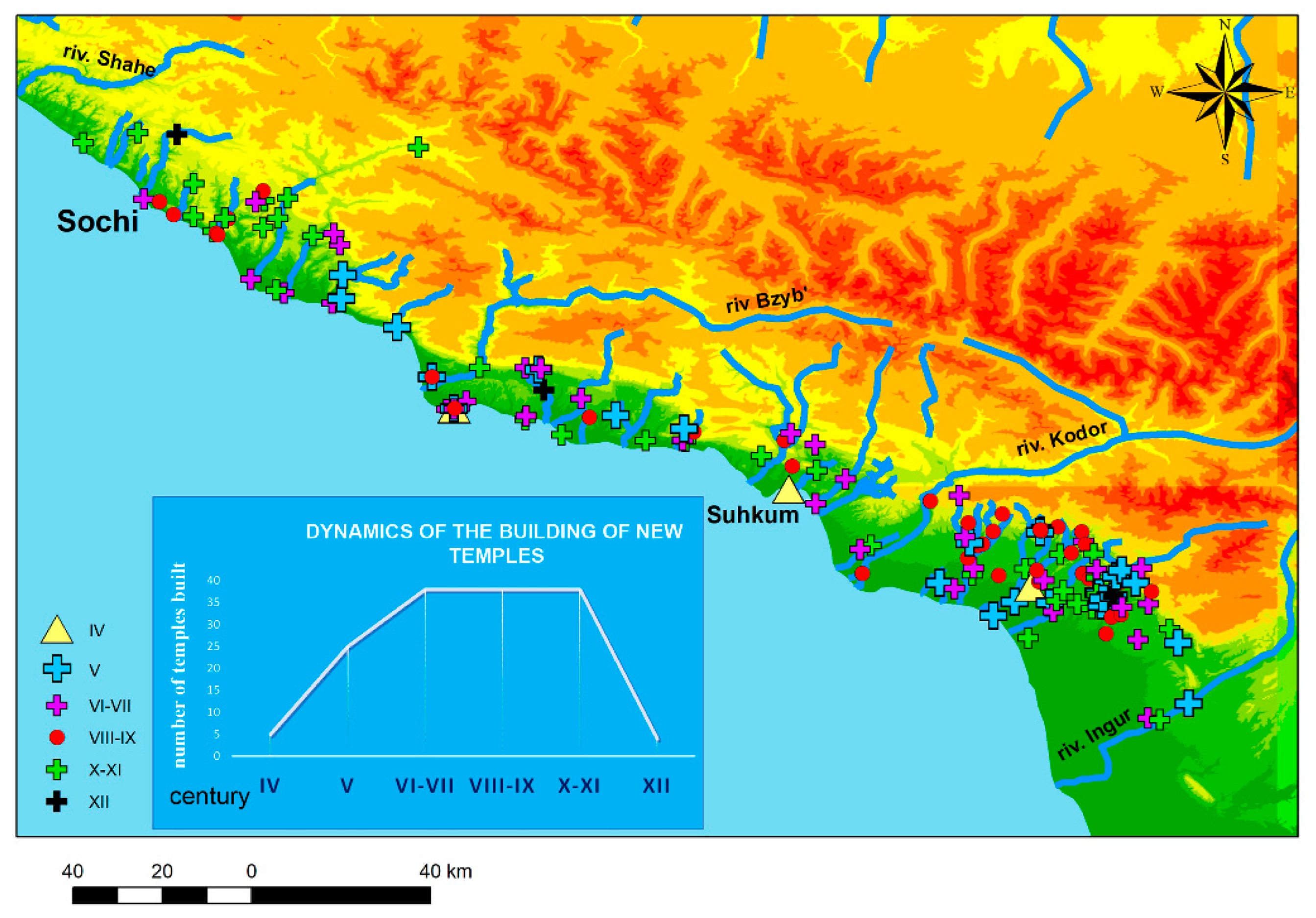
During the Late Antique and early Medieval periods, the most populated, and, therefore, the most favorable zone for living, was the zone from 50 to 150 m above sea level (i.e., flat but not flooded or swampy);
(2)
During the period of the united Abkhazian Kingdom (8th–12th centuries), a significant increase in the population of at least 2.5 times was noted;
(3)
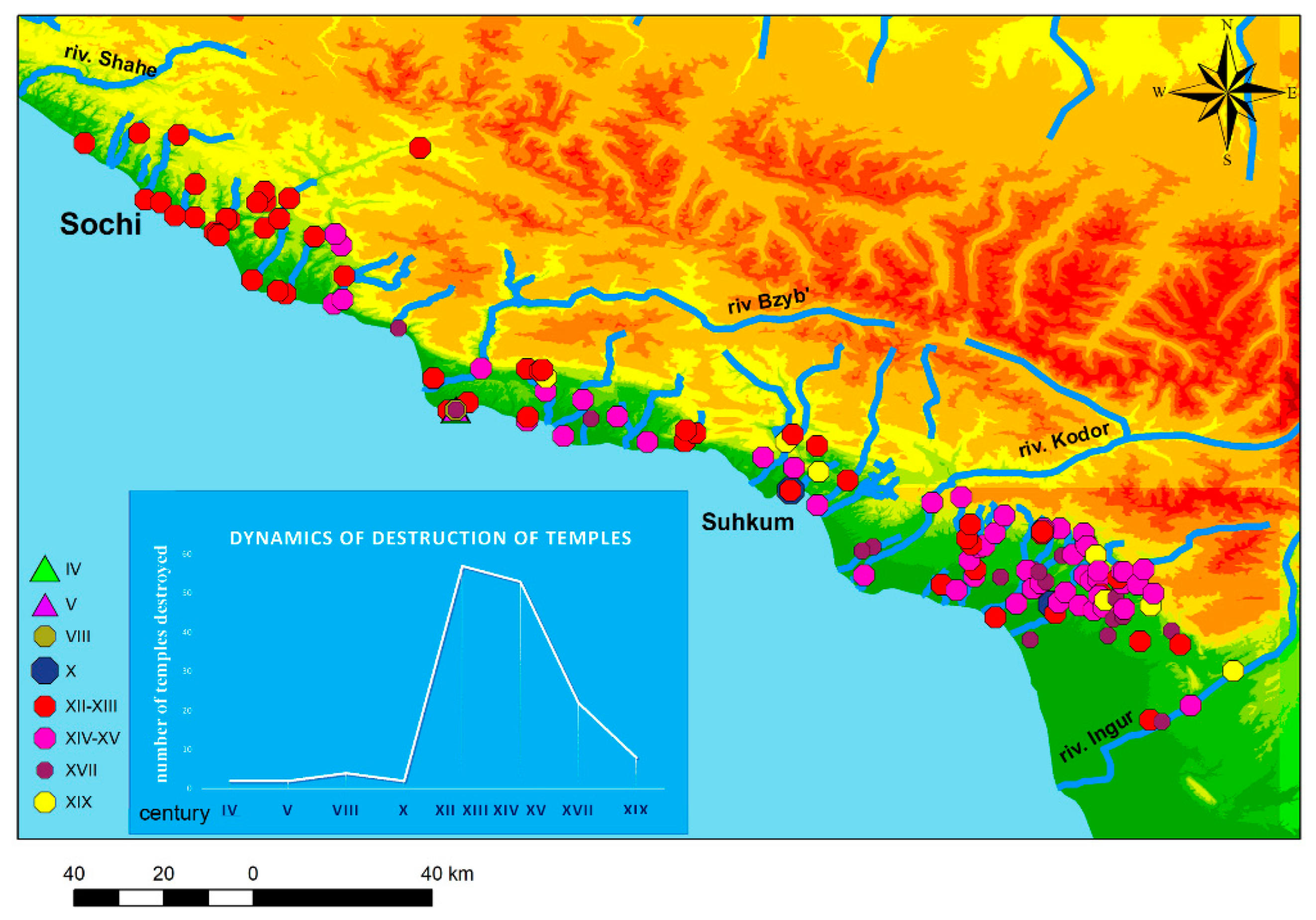
After the 12th–13th centuries, a sharp decline began: New temples were built, and in the 14th–15th centuries, those temples were abandoned and destroyed.
An indirect but objective indicator of population growth during the period of the Abkhazian Kingdom (8th–12th centuries) is a sharp increase in the number of workshops to create pottery and containers for storing food. During this period, the majority of pithoi, which are large storage containers used primarily for the bulk storage of fluids and grains, were found [52].
Moreover, stamps of unified workshops were found. A meshed circle stamp was found in the Mamai-Kale fortress near Sochi [53], as well as during the excavations of the Markul settlement, meaning that pottery was delivered to different parts of northwestern Colchis [54] (Figure 7).
When discussing agriculture, the economic foundation of the Late Antique and Medieval periods, it is important to take into account the results of analyses by related scientific disciplines. Indeed, the basis of nutrition was determined to be agricultural products, after an analysis of the isotopic indicators of nitrogen and carbon in the teeth of buried people. This analysis was carried out on bodies buried at the Markul temple and in the village of Vesyoloe, yielding similar outcomes [17] (Figure 8).
In terms of paleoclimatic studies, attention was drawn to the results of the analysis of the soil of the watershed surface between the Bzugu and Sochapa rivers close to the Experimental Gardens of the Institute of Floriculture and Subtropical Crops (Sochi). The scientists of the Laboratory of Agrochemistry and Soil Science identified a mineral horizon atypical of this soil lying at a depth of 12–30 cm. In contrast to the contemporary natural soil of similar landscapes, the newly formed surface organic horizon, formed on the artificially created medieval carbonate claystone, is characterized by a low content of humus. Taking into account the fact that this horizon was formed to a fully mature state, this lower humus content was likely caused by changes in climatic conditions during the Holocene (the time of the formation of modern soils). The modern Subatlantic period of the Holocene, which continues to this day, is referred to as a regressive climatic stage. Average annual temperatures in the Subatlantic period were, on average, below the levels of the Middle Holocene Atlantic climatic optimum. The low content of humus in the newly formed surface of the organogenic horizon, formed on artificially created medieval masonry of carbonate claystone, served as the basis for the signal point located on this massif and indicated that this site has not been used since the Holocene climatic optimum [55], which, as shown by the climatic curve derived by A.S. Monin and Yu. A. Shishkov (Figure 9), occurred approximately in the 11th–12th centuries.
Second only to agriculture in the Late Antique and Medieval periods was distant pastoralism. An important factor for the efficiency of this method was the length of the grazing period in alpine meadows. During the period of the climatic optimum, “the upper boundary of the vertical distribution of forests in the Alps, in the mountains of Central Europe and in Scandinavia increased by 100–200 m” [29]. Thus, it can be presumed that the period of summer vegetation of alpine meadows was longer. However, after the onset of cooling, this pattern changed. An indicative factor in the study of atsanguars (pastoral stock farming areas) is the presence of arrowheads typical for the Middle Ages and the complete absence of any material associated with firearms. Furthermore, the folk epos depicts atsanguars as the houses of Atsan dwarves, and such homes appear in a mythological, fairy-tale context; this suggests that the true purpose of these structures and their role in the economy of the region have been wiped from people’s memories in recent centuries. Climatic variability was also described in greater detail in the medieval epos. As mentioned above, the Nart epos actively reflects severe cooling as a climatic cataclysm [50].
Thus, on the basis of the above facts, it can be assumed that the end of Early Middle Ages coincides with the deterioration of agriculture in the entire region. Comparing the above conditions with the borders of European territories, the objective correlation becomes obvious. During the Little Ice Age, the Caspian Sea level increased, indicating a rise in the amount of precipitation in the basin of the river Volga and, possibly, reduced evaporation. Chronicles and other historical documents confirm that cold snowy winters and rainy summer seasons became more frequent, and floods occurred more often [29].
Hydrographic networks are also an important factor in the reconstruction of paleogeographic patterns, since the physical and geographical data associated with such networks are extremely important for an objective assessment of the historical and cultural landscape and its development. Let us take the Imereti Lowlands as an example (Figure 10). The hydrographic network in the territory of the Imereti Lowlands area is a part of the Black Sea basin and represented by the Mzymta and Psou rivers, bounding the lowlands, from the west and east, respectively, as well as inland water bodies of natural (sea retreats) and artificial (excavated ponds) origin [56]. The Imereti Lowlands is a territory featuring shallow groundwater (1–2 m), which emerges during the rainy season. Nearly the entire territory of the lowlands is flooded and swampy. The central part is flooded especially intensively during periods of river floods [56]. The effects of flooding are now considerably mitigated by a drainage system designed in the lowlands and consisting of a network of drainage channels. In the period preceding construction, a significant part of the territory was occupied by malarial swamps, namely, lakes filled with silt and peat [57].
Archaeological excavations in the Imereti Lowlands during the construction of the Olympiad facilities in 2010–2014 revealed a number of new sites and made it possible to carry out complete excavations of previously identified archaeological sites. Archaeologists examined almost the entire Imeretiskaya lowlands for two years. All the sites identified by archaeologists and dating from the most ancient sites to the late Middle Ages were located on the outskirts of the valley, while nothing was found in the center where the stadiums were built [57]. Based on the results of the research, it was concluded that there used to be a large freshwater lake on the territory of the Olympic Park, and people settled along its shores.
Another important point is the identification of historical sites along the coast. Particular attention was given to the temple in the park “Southern Cultures”, which is marked on historical navigation maps under the toponym “Saint Sophia”. The fact that this location is marked on navigation maps is of crucial importance and may indicate the presence of a seaport in this area in Antiquity. Indirect evidence for this seaport is the presence of a “bay” mentioned in the reports of I.K. Nedolya, who examined this basilica in the middle of the 20th century [58]. Today, this bay does not exist.
A seaport with a large temple, which, most likely, was located inside a fortress that has not survived (a lake in the center of the lowlands), allows us to draw an analogy with a similar region on the coast that has been fairly well explored by paleogeographers and for which a detailed reconstruction has already been made: the area of Pitsunda Cape and the ancient Roman fortress Great Pitiunt [59]. Here, on the modern area of swampy lakes, there was a large inland lake open to the sea in the Ancient and early Medieval periods. Therefore, it is possible that the lake in the Imereti Lowlands could have been open to the sea. On the site of the temple in the park “Southern Cultures” on the territory of modern Sochi, there was a fortress that was one of the points of the Roman–Byzantine Pontic Limes [60]. The presence of such a fortress in that area appears logical if we analyze the settlement structure, as there are traces of caravan routes directed toward the Krasnaya Polyana region and Aibga Pass [61].
A natural question arises: Why are there no traces of this fortress? The answer lies in the study of seismic activity maps (Figure 4 and Figure 5).
The Imereti Lowlands is a part of the new Sochi–Adler Depression and is separated from Sochi by discontinuities of the Adler flexure–fault zone, which is a seismogenic structure. This territory belongs to the 8–9 point earthquake zone [56]. Traces of damage after earthquakes, in particular, can be seen in the temples of the villages Vesyoloe and Loo [62].
Based on an analysis of the available seismological databases, a consolidated unified-magnitude MS catalogue of historical and instrumentally registered earthquakes was compiled, covering the entire territory of the Western Caucasus (Figure 4). Comparison of the results showed an obvious predominance of seismic activity in the Sochi, Adler, Sukhumi and Ochamchira regions. However, in the Gudauta region, especially in the area of Pitsundsky and Bombor capes, Gali regions, and the the Ingur river basin, such activities were not observed. This result explains the different preservation levels of objects of historic and cultural heritage. Temples similar in time of construction, architecture, and dimensions in the village Vesyoloe and Lykhny have a radically different appearance from each other. According to archaeological research, the temple in Vesyoloe was destroyed between the 11th and 13th centuries, and the temple in Lykhny stands undamaged to this day (Figure 11).
Nothing remains of the fortress in the area of the Southern Cultures Park, and the temple is located at the level of the foundation, while the magnificent medieval cathedral in Pitsunda has survived to this day almost without serious damage; additionally, the walls of the fortress from the ancient period have been preserved.

4. Discussion

The crucial point of the study was to identify the impact of natural factors upon the transformation of the settlement system, which led to deurbanization in northwestern Colchis in the 12th century. A retrospective analysis of literary references revealed the absence of previous studies of the area during this certain period. However, the correlation between changes in the natural environment and the development of human society in earlier eras has long been noted by numerous researchers. Global climate changes, transgressive–regressive developments in ocean affairs, and the glacial–interglacial cycles of the Russian plains and mountain zones have been outlined as the most significant natural factors for the Black Sea area [63].
Historically, the fall of the Byzantine Empire was considered the main factor in the decline and deurbanization of the Black Sea region in the Middle Ages [1] and the changes in trade routes. The present study demonstrated that, for this particular historical period, climate and coastline alterations were the primary causes. Natural factors made the bays (previously convenient for parking ships) shallow, thus leading to the formation of subaerial gravel–pebble deposits, which completely separated the bay from the sea. Steadily, former bays without access to the sea turned into swamps, and the fortresses that guarded those ports lost their importance and trade froze. This picture can be observed in Cape Pitsunda [26]. Recent geo-archaeological examinations initiated by our expedition [64] showed that, according to an analysis of geological deposits in Cape Bombora, the paleogeographic reconstruction is comparable to that of Cape Pitsunda. This has been confirmed, in particular, by the results of studies on the chemical and granulometric composition of deposits, their carbonate content, and the constructed lithological column (Figure 12). In the near future, in order to verify these findings, a wider range of studies, including isotopic, spore pollen, faunal analysis, etc., are planned. In addition, geological research of the Imereti Lowlands is essential. Although archaeological data mostly confirm our assumptions, it is impossible to prove the influence of natural factors on the development of the settlements without conducting comprehensive geological studies at the present level. Therefore, the conclusions of our article, based on an integrated approach, also present new challenges.
It should be noted that the participation of hydrologists and geologists in assessing changes in the channels of large rivers at their confluence with the Black Sea highlights important areas for further research. As can be seen from the corresponding analysis that many coastal have been insufficiently studied by archeologists. Wide estuary valleys were, and remain, the areas at the center of urbanization, so the imbalance between the number of archeological findings and modern settlements cannot be merely accidental. The transgressive–regressive developments that caused active changes in the Black Sea coastline and the contours of the riverbed, in addition to the subsequent modern urbanization of the area, could hide ancient settlements and fortresses vital for study. Moreover, estuarine valleys are the most active zones in the formation of sewage sediments from the entire drainage of large rivers.
Other factors associated with uneven precipitation on the coast are the area of Holocene terraces and their distance from the adjacent mountain slopes. These factors affect the thickness and rate of deposit formation. When studying and identifying architectural sites that have survived seismic impacts, these concerns are not as critical. However, for completely ruined objects, deposit formation is of extreme importance. A completely ruined temple in the zone, featuring the slow formation of soil influxes, is usually a low hill two to three meters in height. However, in the zone of active influx of soils on the foothill terrace, such hills can be completely buried at a maximum height to the horizon of the adjacent territory, which makes them particularly difficult to notice when applying conventional methods. Therefore, the application of an interdisciplinary approach is crucial and will assist in further clarifying and supplementing the layered composition of spatial information in the developed archaeological GIS.

5. Conclusions

This study was based primarily on archaeological data, which served as the basis for analyzing the settlement structures of historical and cultural heritage sites via the GIS. For territories that offer data left by previous inhabitants, analyses were carried out using the methods of various sciences, both natural (climatology, seismology, hydrology, etc.) and humanities-based (folklore, historical cartography, etc.). Synthesis of these data revealed a clear correlation between various factors. In terms of the impact of the physical environment on human evolution, data confirmed that climate change that occurred at the turn of the 12th century led to a crisis in agriculture, producing a decline in both farming and cattle breeding, which certainly affected demography. Seismic activity, noted in the same period, led to the destruction of many buildings (temples and fortresses) and a change in the nature of hydrological networks, which are directly linked to climate change. These changes yielded the formation of swamp lakes on the ground, and, as a result, led to the loss of a number of coastal sites and their abandonment.
Thus, it can be concluded that natural, rather than political, factors played the key role in changing the settlement structure (in terms of both demographic decline and deurbanization). The political changes that took place were the consequence of changes in the physical environment.

Author Contributions

Conceptualization, G.T. and A.K.; methodology, A.K. and V.L.; investigation, G.T. and A.K.; analysis archival materials, V.L. and G.Y.; writing—original draft preparation, G.T. and A.K.; writing—review and editing, G.Y.; visualization, V.L.; supervision, G.T.; project administration, G.Y.; funding acquisition, G.Y. All authors have read and agreed to the published version of the manuscript.

Funding

This research was funded by the Russian Science Foundation, grant number 22-18-00466.

Data Availability Statement

The data presented in this study are available on request from the corresponding author.

Conflicts of Interest

The authors declare no conflict of interest.

References

  1. Voronov, Y.N. Antiquities of Sochi and Its Environs; Prince Publishing House: Krasnodar, Russia, 1979; p. 103. [Google Scholar]
  2. Hager, B.H.; Clayton, R.W.; Richards, M.A.; Comer, R.P.; Dziewonski, A.M. Lower mantle heterogeneity, dynamic topography and the geoid. Nature 1985, 313, 541–545. [Google Scholar] [CrossRef]
  3. King, G.C.P.; Bailey, G.N. Dynamic Landscapes and Human Evolution; GSA Special Paper 471; Geological Society of America: Boulder, CO, USA, 2010. [Google Scholar]
  4. Bolikhovskaya, N.S.; Gorlov, Y.V.; Kaitamba, M.D.; Muller, K.; Porotov, A.V.; Parunin, O.B.; Fuash, E. Changes in the landscape and climatic conditions of the Taman Peninsula over the past 6 thousand years. PIFK 2002, 12, 257–271. [Google Scholar]
  5. Gorlov, Y.V.; Trebeleva, G.V. Integrated paleoecological and archaeological research on the Taman Peninsula. In Archaeological Discoveries 1991–2004. European Russia; Makarov, A.N., Ed.; Institute of Archeology of the Russian Academy of Sciences: Moscow, Russia, 2009; pp. 167–173. [Google Scholar]
  6. Koshelenko, G.A.; Gaibov, V.A.; Trebeleva, G.V. The main channel of the Murgab River in the Parthian time. In GAUDEAMUS IGITUR; Collection of Articles Dedicated to the 60th Anniversary of A.V. Podosinov; Djakson, T.N., Konovalova, I.G., Tsetskhladze, G.R., Eds.; Foundation for the Promotion of Education and Science: Moscow, Russia, 2010; pp. 225–234. [Google Scholar]
  7. Bailey, G.N.; King, G.C.P. Dynamic landscapes and human dispersal patterns: Tectonics, coastlines, and the reconstruction of human habitats. Quat. Sci. Rev. 2011, 30, 1533–1553. [Google Scholar] [CrossRef] [Green Version]
  8. Savage, S.H. GIS in Archaeological Research, Interpreting Space: GIS and Archaeology; Allen, K.M.S., Green, S.W., Zubrow, E.B.W., Eds.; Taylor & Francis: Abingdon, UK, 1990; pp. 22–32. [Google Scholar]
  9. Verhagen, P. Spatial Analysis in Archaeology: Moving into New Territories. In Digital Geoarchaeology; Natural Science in Archaeology; Springer: Cham, Switzerland, 2018; pp. 11–25. [Google Scholar] [CrossRef] [Green Version]
  10. Smekalov, S.L.; Fedorov, D.L. Geoinformation Technologies in Archaeological Research; Baltic State Technical University: St. Petersburg, Russia, 2004; 104p. [Google Scholar]
  11. Trebeleva, G.V. GIS-technologies in Archaeological Conservation in Moscow Region (based on the experience of the Moscow Region Expedition of the IA RAS). In Archeology of the Moscow Region; Materials of the Scientific Seminar; IA RAN: Moscow, Russia, 2004; pp. 216–220. [Google Scholar]
  12. Koshelenko, G.A.; Gaibov, V.A.; Trebeleva, G.V. Archaeological Geoinformation System of Margiana. Archeol. Geoinform. 2007, 4. Available online: https://www.archaeolog.ru/media/periodicals/agis/AGIS-4/Koshelenko/page1.html (accessed on 19 June 2022).
  13. Trebeleva, G.V. Defense of borders of the Bosporian Kingdom during the Roman time: Historical modeling on the basis of GIS-technology. Eirene 2006, 42, 159–166. [Google Scholar]
  14. Mlekuž, D. Time geography, GIS and archaeology. In Proceedings of the 38th Conference on Computer Applications and Quantitative Methods in Archaeology, Granada, Spain, 6–9 April 2010; pp. 1–7. [Google Scholar]
  15. De Gruchy, M.; Jotheri, J.; Alqaragholi, H.; Al-Janabi, J.; Alabdan, R.; Al-Talaqani, H.; Almamouri, G.; Al-Rubaye, H. The Khandaq Shapur: Defense, Irrigation, Boundary, Frontier. Land 2021, 10, 1017. [Google Scholar] [CrossRef]
  16. Lee, T.W.; Walker, J.H. Forests and Farmers: GIS Analysis of Forest Islands and Large Raised Fields in the Bolivian Amazon. Land 2022, 11, 678. [Google Scholar] [CrossRef]
  17. Trebeleva, G.V.; Yurkov, G.Y.; Kizilov, A.S.; Glazov, K.A.; Shvedchikova, T.Y. Complex Investigation (GIS, Photogrammetry, and Natural-Scientific Methods) of the Northwestern Colchis Historical and Cultural Landscape in the Late Antique and Medieval Times. In Proceedings of the Geoarchaeology and Archaeological Mineralogy: 7th Geoarchaeological Conference, Miass, Russia, 19–23 October 2020; Springer Proceedings in Earth and Environmental Sciences. Springer: Berlin/Heidelberg, Germany, 2020; pp. 365–382. [Google Scholar] [CrossRef]
  18. Trebeleva, G.; Glazov, K.; Kizilov, A.; Kizilova, A.; Yurkov, V.; Yurkov, G. Advanced technologies used in digitizing the cultural heritage of northwestern Colchis: The experience of the Markul Expedition. Appl. Sci. 2022, 12, 2052. [Google Scholar] [CrossRef]
  19. Christaller, W. Die Zentralen Orte in Süddeutschland eine Ökonomisch-Geographische Untersuchung über die Gesetzmässigkeit der Verbreitung und Entwicklung der Siedlungen mit Städtischen Funktionen; Wissenschaftliche Buchgesellschaft Publ.: Darmstadt, Germany, 1980; 331p. [Google Scholar]
  20. Trebeleva, G.V.; Sakania, S.M.; Glazov, K.A.; Kizilov, A.S.; Khondzia, Z.G.; Yurkov, G.Y. Project for Cataloging Late Antique and Medieval Temples in Abkhazia: Findings and Future Perspectives. Archit. Archeol. 2020, 2, 54–63. Available online: https://www.archaeolog.ru/media/periodicals/arch-arch/AA-2.pdf (accessed on 9 September 2022).
  21. Trebeleva, G.V.; Yurkov, G.Y.; Gorlov, Y.V.; Tzvinaria, I.I.; Agumaa, A.S.; Sangulia, G.A.; Kaitan, S.G. Abkhaz medieval monuments: Analysis of construction technology and dating issues. Probl. Hist. Philol. Cult. J. Hist. Philol. Cult. Stud. 2013, 2, 297–303. Available online: https://www.pifk.magtu.ru/doc/pifk-02-2013.pdf (accessed on 9 September 2022).
  22. Klemeshova, M.E.; Trebeleva, G.V.; Kizilov, A.S.; Glazov, K.A.; Sokolov, S.V. The experience of using the technique of A.A. Bobrinsky for the study of ceramic vessels in the study of the composition of the molding masses of plinths of medieval temples and fortresses of Eastern Abkhazia. In Proceedings of the VIII All-Russian Scientific Conference “Geoarchaeology and Archaeological Mineralogy”, Miass-Chelyabinsk, Russia, 20–23 September 2021; pp. 97–101. Available online: https://meetings.chelscience.ru/geoarcheology/collection-geoarcheology/ (accessed on 9 September 2022).
  23. Armarchuk, E.A.; Mimokhod, R.A.; Sedov, V.V. Christian church near the village Vesyoloe: Preliminary publication of the results of excavations in 2010. Russ. Archeol. 2012, 3, 78–90. [Google Scholar]
  24. Shmidt, T.S. Hydrographic Description of Rivers, Lakes and Reservoirs. Transcaucasia and Dagestan. Western Transcaucasia. In Resources of Surface Waters of the USSR; Gidrometioizdat: Leningrad, Russia, 1974; Volume 9, 424p. [Google Scholar]
  25. Khmaladze, G.N. Silts Discharged by the Rivers of the Black Sea Coast of the Caucasus; Gidrometioizdat: Leningrad, Russia, 1978; 168p. [Google Scholar]
  26. Balabanov, I.P. Paleographic Prerequisites for the Formation of Modern Natural Conditions and a Long-Term Forecast for the Development of the Holocene Terraces of the Black Sea Coast of the Caucasus; Dalnauka: Vladivostok, Russia, 2009; p. 120. [Google Scholar]
  27. Gerashchenko, I.N. Analysis of Geographical Features and Thermal Regime of the Rivers of the Russian Black Sea Region. Ph.D. Dissertation, Belgorod State University, Belgorod, Russia, 2002; 257p. [Google Scholar]
  28. Gerashchenko, I.N. Hydrological and Hydrographic Characteristics of Some River Basins in the Humid Subtropics of the Black Sea region of the Krasnodar Territory. Int. Sci. J. Symb. Sci. 2017, 3, 230–232. Available online: https://cyberleninka.ru/article/n/gidrologo-gidrograficheskaya-harakteristika-nekotoryh-bassenov-rek-vlazhnyh-subtropikov-prichernomorya-krasnodarskogo-kraya/viewer (accessed on 19 June 2022).
  29. Monin, A.S.; Shishkov, Y.A. Climate History; Gidrometeoizdat: Leningrad, Russia, 1979; 406p. [Google Scholar]
  30. Nikonov, A.A. A New Approach to Assessing the Seismic Potential and Hazard on the Black Sea Coast of the Caucasus (Based on Archeoseismic Data). Available online: https://www.researchgate.net/publication/301370692 (accessed on 19 June 2022).
  31. Balabanov, I.P.; Nikiforov, S.P. Gagra Bay. Recreational Potential of Natural-Geological Conditions of the Coastal-Marine Zone; Publishing House “Author’s Book”: Moscow, Russia, 2016; 288p. [Google Scholar]
  32. Akimov, V.A.; Zaitsev, V.A.; Larkov, A.S.; Lutikov, A.I.; Ovsyuchenko, A.N.; Panina, L.V.; Rogozhin, E.A.; Rodina, S.N.; Sysolin, A.I. Seismic hazard maps of the Northwestern and Central Caucasus in a detailed scale. Issues Eng. Seismol. 2019, 46, 57–74. [Google Scholar]
  33. Stiros, S. Identification of earthquakes from archaeological data: Methodology, criteria and limitation. In Archaeoseimology; Fitch Laboratory Occasional Papers No. 7; Stiros, S., Jones, R., Eds.; British School at Athens: Athens, Greece, 1996; pp. 129–152. [Google Scholar]
  34. Galadini, F.; Hinzen, K.-G.; Stiros, S. Archaeoseismology: Methodological issues and procedure. J. Seismol. 2006, 10, 395–414. [Google Scholar] [CrossRef] [Green Version]
  35. Zhuravlev, A.P. Seismic Archeology—The Science of the Third Millennium; Zemlia Zaonezhia: Petrozavodsk, Russia, 1999; 85p. [Google Scholar]
  36. Martín-González, F. Earthquake damage orientation to infer seismic parameters in archaeological sites and historical earthquakes. Tectonophysics 2018, 724–725, 137–145. [Google Scholar] [CrossRef]
  37. Vinokurov, N.I.; Nikonov, A.A. Traces of an earthquake of the Antic time in the west of the European Bosporus. Russ. Archeol. 1998, 4, 98–114. [Google Scholar]
  38. Kazmer, M.; Kolaiti, E. Earthquake-induced deformations at the Lion Gate, Mycenae, Greece. In Proceedings of the 6th International INQUA Meeting on Paleoseismology, Active Tectonics and Archaeoseismology, Pescina, Fucino Basin, Italy, 19–24 April 2015; Volume 27, pp. 248–251. Available online: https://www.researchgate.net/publication/292139936_Earthquake-induced_deformations_at_the_Lion_Gate_Mycenae_Greece (accessed on 9 September 2022).
  39. Ambraseys, N.; Psycharis, I. Assessment of the long-term seismicity of Athens from two classical columns. Bull. Earthq. Eng. 2012, 10, 1635–1666. [Google Scholar] [CrossRef]
  40. Papantoniou, G.; Vionis, A.K. Landscape Archaeology and Sacred Space in the Eastern Mediterranean: A Glimpse from Cyprus. Land 2017, 6, 40. [Google Scholar] [CrossRef] [Green Version]
  41. Tourloukis, V. The Early and Middle Pleistocene Archaeology Record of Greece: Current Status and Future Prospects. Ph.D. Thesis, Leiden University, Leiden, The Netherlands, 2010. Available online: https://scholarlypublications.universiteitleiden.nl/handle/1887/16150 (accessed on 9 September 2022).
  42. Buck, V.A. Archeoseismology in Atlanta Region, Central Mainland Greece: Theory, Method, and Practice; BAR Publishing: Oxford, UK, 2006; 120p, Available online: https://www.barpublishing.com/archaeoseismology-in-atalanti-region-central-mainland-greece.html (accessed on 9 September 2022).
  43. Altunel, E. Evidence for damaging historical earthquakes at Priene, western Turkey. Turk. J. Earth Sci. 1998, 7, 25–35. [Google Scholar]
  44. Al-Tarazi, E.A.; Korjenkov, A.M. Archaeoseismological investigation of the ancient Ayla site in the city of Aqaba, Jordan. Nat. Hazards 2007, 42, 47–66. [Google Scholar] [CrossRef]
  45. Saucier, R.T. Geoarchaeological evidence of strong prehistoric earthquakes in the New Madrid (Missouri) seismic zone. Geology 1991, 19, 296–298. [Google Scholar] [CrossRef]
  46. Ambraseys, N.N.; Melville, C.; Adams, R. The Seismicity of the Egypt, Arabia, and the Red Sea, a Historical Review; Cambridge University Press: Cambridge, UK, 1994; 181p. [Google Scholar]
  47. Galli, P.; Galadini, F. Surface faulting of archaeological relics. A review of case histories from the Dead Sea to the Alps. Tectonophysics 2001, 335, 291–312. [Google Scholar] [CrossRef]
  48. Satuluri, S.; Gadhavi, M.S.; Malik, J.N.; Vikrama, B. Quantifying seismic induced damage at ancient site Manjal located in Kachchh Mainland region of Gujarat, India. J. Archaeol. Sci. Rep. 2020, 33, 102486. [Google Scholar] [CrossRef]
  49. Karakhanian, A.S.; Trifonov, V.G.; Ivanova, T.P.; Avagyan, A.; Rukieh, M.; Minini, H.; Dodonov, A.E.; Bachmanov, D.M. Seismic deformation in the St. Simeon Monasteries (Qal’at Sim’an), Northwestern Syria. Tectonophysics 2008, 453, 122–147. [Google Scholar] [CrossRef]
  50. Rakhno, K.Y. Cooling in the Nart epic of Ossetians and Avesta. In Proceedings of the Nartology in the 21st Century: Modern Paradigms and Interpretations, Collection of Scientific Papers, Vladikavkaz, Russia, 6–7 October 2019; pp. 54–55. [Google Scholar]
  51. Trebeleva, G.V.; Sakania, S.M.; Kizilov, A.S.; Glazov, K.A. Abzhui Abkhazia, the area of the Tamysh (Toumysh) and Dgamsh river basins: Reconstruction of the settlement structure based on a spatial analysis of temple architecture monuments. Probl. Reg. Ecol. 2020, 6, 72–85. [Google Scholar]
  52. Kizilov, A.S.; Platonov, A.P. Agriculture of Greater Sochi from the Eneolithic to the Middle Ages based on materials from archaeological and historical sources. Subtrop. Ornam. Gard. 2021, 77, 15–25. [Google Scholar]
  53. Sizov, V.I. Eastern coast of the Black Sea. In Archaeological Excursions; Uvarova, P., Ed.; Imperial Moscow Archaeological Society: Moscow, Russia, 1889; Volume 2, p. 7. [Google Scholar]
  54. Yurkov, V.G.; Klemeshova, M.E.; Trebeleva, G.V. Issues of the chronology of the Markul settlement in the light of new discoveries in 2021. In Proceedings of the Actual Archeology 6—Proceedings of the International Scientific Conference of Young Scientists, St. Petersburg, Russia, 4–7 April 2022; pp. 194–197. [Google Scholar]
  55. Kizilov, A.S.; Zakharikhina, L.V. New Medieval objects of the on the left bank of the Sochapa River as evidence of the peculiarities of the life of a medieval person and the spatial and temporal variability of soil formation factors. In Proceedings of the IX “Anfimov Readings” on the Archeology of the Western Caucasus, Anapa, Russia, 29–31 May 2019; pp. 158–161. [Google Scholar]
  56. Osipov, V.I.; Vadachkoriya, O.A.; Mamaev, Y.A.; Yastrebov, A.A. Geotechnical conditions and protection of the construction site of the Olympic Park in Sochi. Geoecol. Eng. Geol. Hydrogeol. Geocriol. 2010, 6, 483–493. [Google Scholar]
  57. Kryukov, A.V. Objects of cultural heritage within the boundaries of the natural ornithological park in the Imereti lowland: Composition and problems of conservation. In Proceedings of the Sustainable Development of Specially Protected Natural Territories, Collection of Articles of the V All-Russian Scientific and Practical Conference, Sochi, Russia, 10–12 October 2018; pp. 169–178. [Google Scholar]
  58. Nedolya, I.K. Report on the Survey of Medieval Sites in the Greater Sochi Region in 1954–1968; Archive of the Sochi Branch of the Russian Geographical Society: Adler, Russia, 1969. [Google Scholar]
  59. Trebeleva, G.; Glazov, K.; Kizilov, A.; Sakania, S.; Yurkov, V.; Yurkov, G. Roman fortress Pitiunt: 3D-reconstruction of the monument based on the materials of archaeological research and geological paleoreconstructions. Appl. Sci. 2021, 11, 4814. [Google Scholar] [CrossRef]
  60. Trebeleva, G.V.; Kizilov, A.S. Once again to the question of the “Pontic Limes”, or on the geographical and geopolitical principles of the location of the ancient fortifications of the Black Sea coast in ancient times. In Proceedings of the Ancient and Traditional Cultures in Interaction with the Environment: Problems of Historical Reconstruction: Materials of the I International Interdisciplinary Conference, Chelyabinsk, Russia, 13–15 April 2021; Kupriyanova, E.V., Ed.; Chelyabinsk Publishing House: Chelyabinsk, Russia, 2021; pp. 51–60. [Google Scholar]
  61. Kizilov, A.S.; Trebeleva, G.V. To the question of the geographical and geopolitical principles of the location of the ancient fortifications of the Black Sea coast: Between the Bosporus and Abazgia. Probl. Reg. Ecol. 2020, 3, 98–111. [Google Scholar] [CrossRef]
  62. Ovchinnikova, B.B. Ten years of the Loo Archaeological Expedition (1987–1997). In News of the Ural State University; Ural State University: Ekaterinburg, Russia, 1997; Volume 3, pp. 119–123. [Google Scholar]
  63. Lisitsyn, A.P. (Ed.) The Black Sea System; Scientific World: Moscow, Russia, 2018; 808p. [Google Scholar]
  64. Trebeleva, G.V.; Chepalyga, A.L.; Sakania, S.M.; Sadchikova, T.A.; Yurkov, G.Y. Geoarchaeological Studies of the Coast of NORTHWESTERN Colchis Geoarchaeology and Archaeological Mineralogy—2022; Scientific Publication; YuUrGGPU Publishing House: Miass-Chelyabinsk, Russia, 2022; pp. 14–19. Available online: https://www.academia.edu/89025738/Geoarkheologia_2022_Bombora (accessed on 9 November 2022).
Figure 1. The territory of northwestern Colchis on a satellite image.
Land 11 02202 g001
Figure 2. Map of temples with a chronological classification according to the date of construction of the temple.
Land 11 02202 g002
Figure 3. Map of temples with a chronological classification according to the date of destruction of the temple.
Land 11 02202 g003
Figure 4. A map of earthquake centers (pink circles) recorded by our team (data from the centers are taken from [32]) and the Markul settlement (red cross), where multiple traces of earthquakes and landslides were recorded after our expedition’s excavations.
Land 11 02202 g004
Figure 5. Synthesis of tectonic data in GIS according to the data from seismologists: The raster with red lines and numbers indicates longitudinal (5, 5a, 6, 6a, 7, 8) and transverse (1, 2, 3, 4) tectonic faults [31]; selection of faults according to our field studies (red dotted line).
Land 11 02202 g005
Figure 6. Temples in the areas of the Dgamsh and Mokva rivers.
Land 11 02202 g006
Figure 7. The stamp on the pithoi in the form of a meshed circle and the places where they were found marked on the map.
Land 11 02202 g007
Figure 8. Maps and isotopic indicators of nitrogen and carbon: comparison of data from the village of Vesyoloe (black dots) and the Markul settlement (red dots), and samples of animals (crosses).
Land 11 02202 g008
Figure 9. Climatic curve for the last two thousand years based on data on the width of the rings for one of the pine species (in mm); the curve was created based on the data given in [29].
Land 11 02202 g009
Figure 10. Temples in the Imereti Lowlands.
Land 11 02202 g010
Figure 11. Lykhny temple (a), Pitsundsky cathedral (b), and fortress (orthophotoplan) (c).
Land 11 02202 g011
Figure 12. The structure and composition of the section of sedimentary rocks found in Cape Bombora: 1. calcite; 2. dolomite; 3. sand; 4. loose pebbles; 5. dense pebbles; 6. siltstone; 7. shell detritus; 8. fragments of lime microorganisms; 9. fragments of plant tissue; 10. carbonate concretions; 11. sod layer. Loss on Ignition (LOI) curve No. 550 indicates the amount of combustible organics, No. 950 shows the amount of carbonate minerals that release carbon dioxide at specified temperatures.
Land 11 02202 g012
Publisher’s Note: MDPI stays neutral with regard to jurisdictional claims in published maps and institutional affiliations.

