

Introducing Geotourism to Diversify the Visitor Experience in Protected Areas and Reduce Impacts on Overused Attractions


Abstract
:1. Introduction
2. Methods
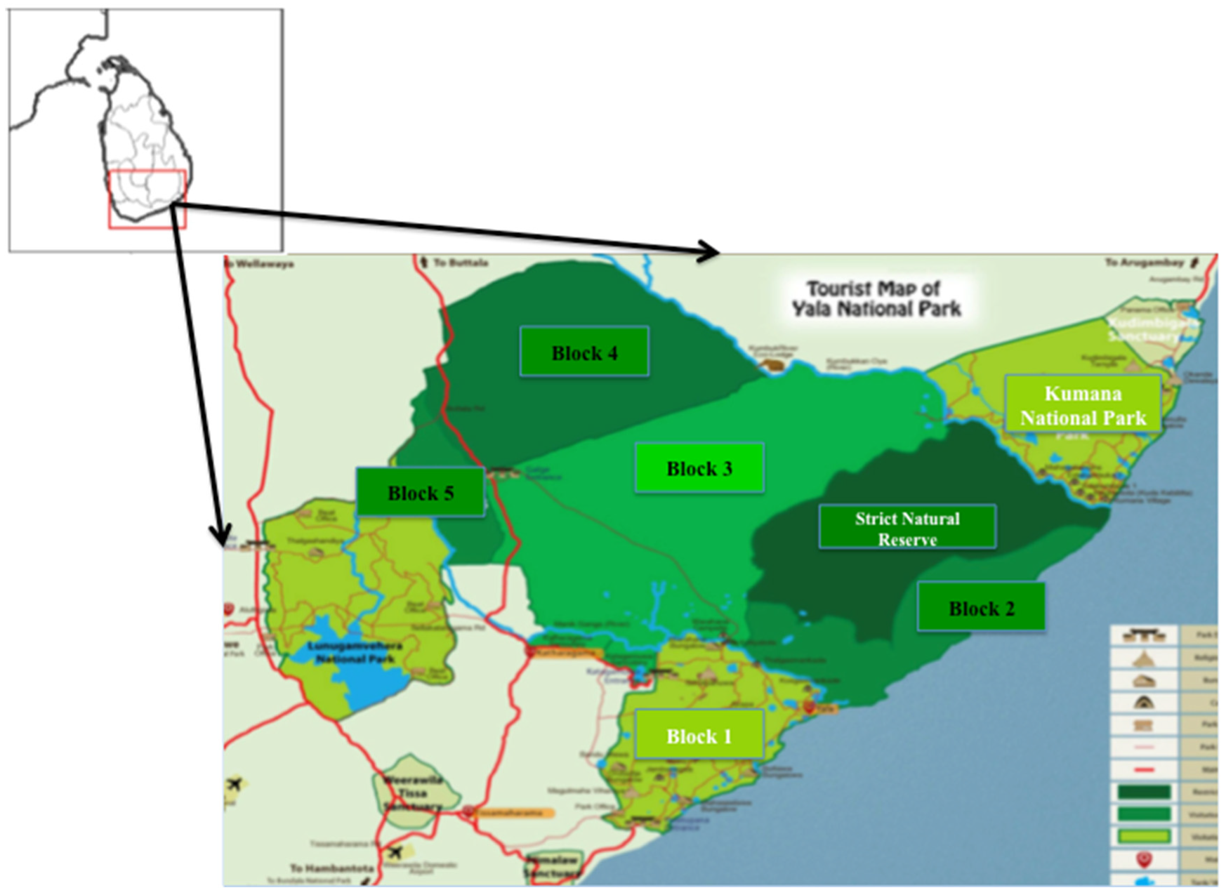
2.1. Study Area
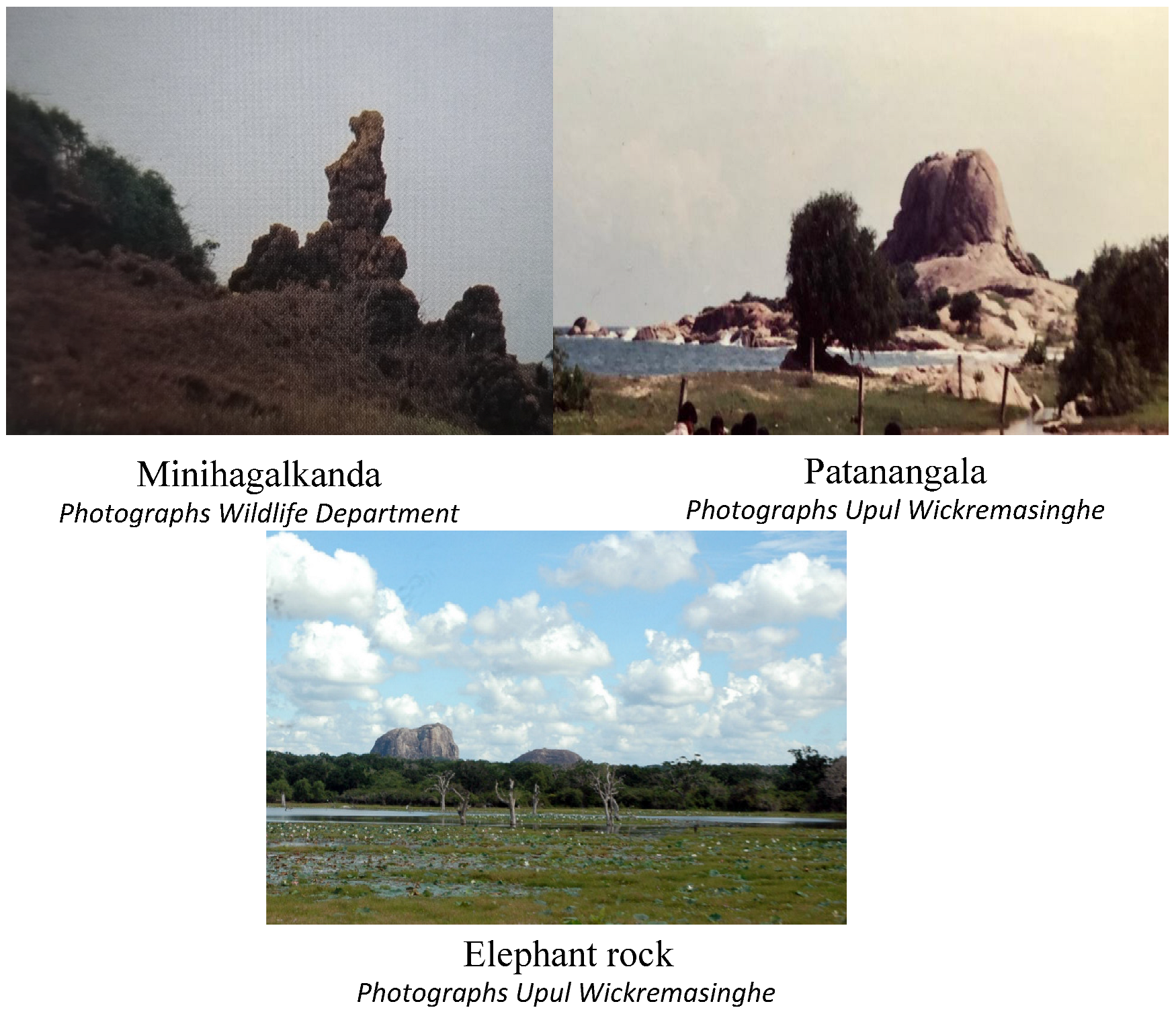
2.2. Study Sites
2.3. Assessment Procedure
3. Results and Discussion
4. Conclusions
Author Contributions
Funding
Data Availability Statement
Acknowledgments
Conflicts of Interest
References
- Ólafsdóttir, R.; Tverijonaite, E. Geotourism: A systematic literature review. Geosciences 2018, 8, 234. [Google Scholar] [CrossRef] [Green Version]
- Xu, K.; Wu, W. Geoparks and Geotourism in China: A Sustainable Approach to Geoheritage Conservation and Local Development—A Review. Land 2022, 11, 1493. [Google Scholar] [CrossRef]
- Rutherford, J.; Kobryn, H.; Newsome, D. A case study in the evaluation of geotourism potential through geographic information systems: Application in a geology-rich island tourism hotspot. Curr. Issues Tour. 2015, 18, 267–285. [Google Scholar] [CrossRef]
- Galvão, A.; Mascarenhas, C.; Marques, C.; Braga, V. Geotourism as Promoter of Sustainability Development: A Systematic Review and Research Agenda. Econ. Manag. Geotourism 2022, 2022, 1–18. [Google Scholar]
- Hose, T.A.; Vasiljević, D.A. Defining the nature and purpose of modern geotourism with particular reference to the United Kingdom and South-East Europe. Geoheritage 2012, 4, 25–43. [Google Scholar] [CrossRef]
- Megerle, H.E. Calcerous tufa as invaluable geotopes endangered by (Over) tourism: A case study in the UNESCO global geopark swabian alb, germany. Geosciences 2021, 11, 198. [Google Scholar] [CrossRef]
- Hose, T.A. 3G’s for modern geotourism. Geoheritage 2012, 4, 7–24. [Google Scholar] [CrossRef]
- Hose, T.A. Geotourism: Appreciating the deep time of landscapes. In Niche Tourism 2007; Routledge: New York, NY, USA, 2007; pp. 27–37. [Google Scholar]
- Vujičić, M.D.; Vasiljević, D.A.; Marković, S.B.; Hose, T.A.; Lukić, T.; Hadžić, O.; Janićević, S. Preliminary geosite assessment model (GAM) and its application on Fruška Gora Mountain, potential geotourism destination of Serbia. Acta Geogr. Slov. 2011, 51, 361–376. [Google Scholar] [CrossRef]
- Kubalíková, L.; Drápela, E.; Kirchner, K.; Bajer, A.; Balková, M.; Kuda, F. Urban geotourism development and geoconservation: Is it possible to find a balance? Environ. Sci. Policy 2021, 121, 1–10. [Google Scholar] [CrossRef]
- Eder, F.W.; Patzak, M. Geoparks—Geological attractions: A tool for public education, recreation and sustainable economic development. UNESCO 2004, Division of Earth Sciences. Epis. J. Int. Geosci. 2004, 27, 162–164. [Google Scholar]
- Khalaf, E.E.D.A.H. Karst Heritage as a Tourist Attraction: A Case Study in the White Desert National Park, Western Desert, Egypt. Geoheritage 2022, 14, 94. [Google Scholar] [CrossRef]
- Stolz, J.; Megerle, H.E. Geotrails as a Medium for Education and Geotourism: Recommendations for Quality Improvement Based on the Results of a Research Project in the Swabian Alb UNESCO Global Geopark. Land 2022, 11, 1422. [Google Scholar] [CrossRef]
- Carayannis, E.; Grigoroudis, E. Quadruple innovation Helix and smart specialization: Knowledge Production and National competitiveness. Foresight STI Gov. 2016, 10, 31–42. [Google Scholar] [CrossRef]
- Preez, D.; Elizabeth, A. The contribution of geological features to visitor experiences: Comparison between two geotourism attractions in South Africa. Geo J. Tour. Geosites 2019, 26, 874–888. [Google Scholar] [CrossRef]
- Benur, A.M.; Bramwell, B. Tourism products development and product diversification in destinations. Tour. Manag. 2015, 50, 213–224. [Google Scholar] [CrossRef]
- Knobloch, U.; Robertson, K.; Aitken, R. (Mis) Understanding the nature of tourist experiences. Tour. Anal. 2014, 19, 599–608. [Google Scholar] [CrossRef]
- Stoleriu, O.M.; Brochado, A.; Rusu, A.; Lupu, C. Analyses of Visitors’ Experiences in a Natural World Heritage Site Based on TripAdvisor Reviews. Visit. Stud. 2019, 22, 192–212. [Google Scholar] [CrossRef]
- Dowling, R.; Newsome, D. (Eds.) Handbook of Geotourism; Edward Elgar Publishing: Cheltenham, UK, 2018. [Google Scholar]
- Gordon, J. Geoheritage, geotourism and the cultural landscape: Enhancing the visitor experience and promoting geoconservation. Geosciences 2018, 8, 136. [Google Scholar] [CrossRef] [Green Version]
- Grobbelaar, L.; Bouwer, S.; Hermann, U.P. An exploratory investigation of visitor motivations to the Baberton-Makhonjwa Geotrail, South Africa. Geo J. Tour. Geosites 2019, 25, 283–292. [Google Scholar] [CrossRef]
- Farsani, N.T.; Coelho, C.; Costa, C. Geotourism and geoparks as novel strategies for socio-economic development in rural areas. Int. J. Tour. Res. 2011, 13, 68–81. [Google Scholar] [CrossRef]
- Wolf, I.D.; Croft, D.B. Minimizing disturbance to wildlife by tourists approaching on foot or in a car: A study of kangaroos in the Australian rangelands. Appl. Anim. Behav. Sci. 2010, 126, 75–84. [Google Scholar] [CrossRef]
- Wolf, I.D.; Croft, D.B.; Green, R.J. Nature conservation and tourism: A paradox? Environments 2019, 6, 104. [Google Scholar] [CrossRef]
- Gordon, J.E.; Baker, M. Appreciating Geology and the Physical Landscape in Scotland: From Tourism of Awe to Experiential Re-Engagement. Geol. Soc. Lond. Spec. Publ. 2016, 417, 25–40. [Google Scholar] [CrossRef]
- Aquino, R.S.; Schänzel, H.A.; Hyde, K.F. Unearthing the geotourism experience: Geotourist perspectives at Mount Pinatubo, Philippines. Tour. Stud. 2018, 18, 41–62. [Google Scholar] [CrossRef] [Green Version]
- Dowling, R. Geotourism’s Global Growth. Geoheritage 2011, 3, 1–13. [Google Scholar] [CrossRef]
- Sumanapala, H.D.P.; Kotagama, S.W.; Perera, P.K.P.; Galahitiyawe, N.W.K.; Suranga, D.A.C.S. Comparison of characteristics of Asian and non-Asian tourists visiting eco-lodges in Sri Lanka. Sri Lanka J. Soc. Sci. 2017, 40, 119–126. [Google Scholar] [CrossRef]
- Patroni, J.; Newsome, D.; Kerr, D.; Sumanapala, D.P.; Simpson, G.D. Reflecting on the human dimensions of wild dolphin tourism in marine environments. Tour. Hosp. Manag. 2019, 25, 141–160. [Google Scholar] [CrossRef]
- Hose, T.A. Geotourism and geoconservation. Geoheritage 2012, 4, 1–5. [Google Scholar] [CrossRef] [Green Version]
- Cengiz, C.; Şahin, Ş.; Cengiz, B.; Başkır, M.B.; Keçecioğlu Dağlı, P. Evaluation of the visitor understanding of coastal geotourism and geoheritage potential based on sustainable regional development in western Black Sea Region, Turkey. Sustainability 2021, 13, 11812. [Google Scholar] [CrossRef]
- Moyle, B.D.; Scherrer, P.; Weiler, B.; Wilson, E.; Caldicott, R.; Nielsen, N. Assessing preferences of potential visitors for nature-based experiences in protected areas. Tour. Manag. 2017, 62, 29–41. [Google Scholar] [CrossRef]
- Ruban, D.A. Geotourism—A geographical review of the literature. Tour. Manag. Perspect. 2015, 15, 1–15. [Google Scholar] [CrossRef]
- Tessema, G.A.; van Der Borg, J.; Minale, A.S.; Van Rompaey, A.; Adgo, E.; Nyssen, J.; Asrese, K.; Van Passel, S.; Poesen, J. Inventory and assessment of geosites for geotourism development in the Eastern and Southeastern Lake Tana Region, Ethiopia. Geoheritage 2021, 13, 1–23. [Google Scholar] [CrossRef]
- Farsani, T.N.; Coelho, C.; Costa, C. Geotourism and geoparks as gateways to socio-cultural sustainability in Qeshm rural areas, Iran. Asia Pac. J. Tour. Res. 2012, 17, 30–48. [Google Scholar] [CrossRef]
- Paungya, N.; Singtuen, V.; Won-In, K. The preliminary geotourism study in Phetcahbun Province, Thailand. Geo J. Tour. Geosites 2020, 31, 1057–1067. [Google Scholar] [CrossRef]
- Swarna, K.; Biswas, S.K.; Harinarayana, T. Development of geotourism in Kutch Region, Gujarat, India: An innovative approach. J. Environ. Prot. 2013, 4, 40553. [Google Scholar] [CrossRef] [Green Version]
- Khoshraftar, R.; Farsani, N.T. An Introduction to Geotourism of the Mahneshan County. Geoheritage 2022, 14, 28. [Google Scholar] [CrossRef]
- Farsani, N.T.; Coelho, C.; Costa, C. Geoparks and Geotourism: New Approaches to Sustainability for the 21st Centuary; Universal-Publisher: Boca Raton, FL, USA, 2011; Volume 13, pp. 68–81. [Google Scholar]
- Hernández, W.; Dóniz-Páez, J.; Pérez, N.M. Urban Geotourism in La Palma, Canary Islands, Spain. Land 2022, 11, 1337. [Google Scholar] [CrossRef]
- Wolf, I.D.; Hagenloh, G.; Croft, D.B. Visitor monitoring along roads and hiking trails: How to determine usage levels in tourist sites. Tour. Manag. 2012, 33, 16–28. [Google Scholar] [CrossRef]
- Sumanapala, D.; Dimmock, K.; Wolf, I.D. A review of ecological impacts from recreational SCUBA diving: Current evidence and future practice. Tour. Hosp. Res. 2022. [Google Scholar] [CrossRef]
- Wolf, I.D.; Croft, D.B. Impacts of tourism hotspots on vegetation communities show a higher potential for self-propagation along roads than hiking trails. J. Environ. Manag. 2014, 143, 173–185. [Google Scholar] [CrossRef]
- Shang, Q.; Liu, Y.; Li, Q. Effects of Tourism Trampling on Soil Nitrogen Mineralization in Quercus variabilis Blume Forests Varies with Altitudes in the Climate Transition Zone. Forests 2022, 13, 1467. [Google Scholar] [CrossRef]
- Dragovich, D.; Bajpai, S. Managing Tourism and Environment—Trail Erosion, Thresholds of Potential Concern and Limits of Acceptable Change. Sustainability 2022, 14, 4291. [Google Scholar] [CrossRef]
- Wolf, I.D.; Hagenloh, G.; Croft, D.B. Vegetation moderates impacts of tourism usage on bird communities along roads and hiking trails. J. Environ. Manag. 2013, 129, 224–234. [Google Scholar] [CrossRef] [PubMed]
- Sumanapala, D.; Wolf, I.D. Man-made impacts on emerging geoparks in the Asian region. Geoheritage 2020, 12, 64. [Google Scholar] [CrossRef]
- Scholte, P.; Pays, O.; Adam, S.; Chardonnet, B.; Fritz, H.; Mamang, J.B.; Moritz, M. Conservation overstretch and long-term decline of wildlife and tourism in the Central African savannas. Conserv. Biol. 2022, 36, 13860. [Google Scholar] [CrossRef]
- Sunkar, A.; Lakspriyanti, A.P.; Haryono, E.; Brahmi, M.; Setiawan, P.; Jaya, A.F. Geotourism Hazards and Carrying Capacity in Geosites of Sangkulirang-Mangkalihat Karst, Indonesia. Sustainability 2022, 14, 1704. [Google Scholar] [CrossRef]
- Vitanage, P.W. A study of the geomorphology and the morphotectonics of Ceylon. In UNESCO/ESCAFE 2nd International Seminar on Geochemical Prospects, Methods and Techniques; UNESCO: Bangkok, Thailand, 1970. [Google Scholar]
- Chandrajith, R. Geology and geomorphology. In The Soils of Sri Lanka; Springer: New York, NY, USA, 2020; pp. 23–34. [Google Scholar]
- Vitanage, P. Post-Precambrian uplifts and regional neotectonic movements in Ceylon. In Proceedings 24th IGC; Montréal: Montreal, QC, Canada, 1972; pp. 642–654. [Google Scholar]
- Newsome, D. An ‘ecotourist’s recent experience in Sri Lanka. J. Ecotourism 2013, 12, 210–220. [Google Scholar] [CrossRef]
- Sumanapala, D. A review: National parks in Sri Lanka and impending development and research. Asian J. Tour. Res. 2018, 3, 121–147. [Google Scholar] [CrossRef]
- Sumanapala, D.; Wolf, I.D. The changing face of wildlife tourism during the COVID-19 pandemic: An opportunity to strive towards sustainability? Curr. Issues Tour. 2022, 25, 357–362. [Google Scholar] [CrossRef]
- Jazeel, T. ‘Nature’, nationhood and the poetics of meaning in Ruhuna (Yala) National Park, Sri Lanka. Cult. Geogr. 2005, 12, 199–227. [Google Scholar] [CrossRef] [Green Version]
- Indraratne, S.P. Soil mineralogy. In The Soils of Sri Lanka; Springer: Berlin/Heidelberg, Germany, 2020; pp. 35–47. [Google Scholar]
- Weerasinghe, U.M.I.R.K.; Kariyawasm, D.; De Zoysa, M. Ruhuna (Yala) National Park in Sri Lanka: Visitors, Visitation and Eco-Tourism. Flora 2003, 25, 43–40. [Google Scholar]
- Dassanayake, A.R.; De Silva, G.G.R.; Mapa, R.B. Major Soils of the Dry Zone and Their Classification. In The Soils of Sri Lanka; Springer: Berlin/Heidelberg, Germany, 2020; pp. 49–67. [Google Scholar]
- Withanachchi, C.R. An Archaeological Insight into the Coast (Karatvita) Tanks of Sri Lanka; Humanities and the Social Sciences (ICHSS); University of Peradeniya: Kandy, Sri Lanka, 2016; p. 256. [Google Scholar]
- Zangmo, G.T.; Kagou, A.D.; Nkouathio, D.G.; Gountié, M.D.; Kamgang, P. The volcanic geoheritage of the Mount Bamenda calderas (Cameroon line): Assessment for geotouristic and geoeducational purposes. Geoheritage 2017, 9, 255–278. [Google Scholar] [CrossRef]
- Grandgirard, V. Géomorphologie et gestion du patrimoine naturel: La mémoire de la Terre est notre mémoire. Geogr. Helv. 1997, 52, 47–56. [Google Scholar] [CrossRef]
- Coratza, P.; Giusti, C. Methodological proposal for the assessment of the scientific quality of geomorphosites. Alp. Mediterr. Quat. 2005, 18, 307–313. [Google Scholar]
- Brilha, J. Inventory and quantitative assessment of geosites and geodiversity sites: A review. Geoheritage 2016, 8, 119–134. [Google Scholar] [CrossRef] [Green Version]
- Nguyen-Thuy, D.; Ta, P.H.; Nguyen-Van, H.; Van Dinh, H.; Van Dang, B.; Dang, N.H.; Hoang, T.T. Evaluation of Geological Heritage of Geosites for a Potential Geopark in Binh Thuan–Ninh Thuan Coastal Zone, Vietnam. Geoheritage 2019, 11, 689–702. [Google Scholar] [CrossRef]
- Pereira, P.; Pereira, D.; Caetano Alves, M.I. Geomorphosite assessment in Montesinho Natural Park (Portugal). Geogr. Helv. 2007, 62, 159–168. [Google Scholar] [CrossRef] [Green Version]
- Garcia, M.D.G.M.; Lama, E.A.; Martins, L.; Mazoca, C.E.M.; Bourotte, C.L. Inventory and assessment of geosites to stimulate regional sustainable management: The northern coast of the state of São Paulo, Brazil. An. Acad. Bras. Ciências 2019, 1–24. [Google Scholar] [CrossRef] [Green Version]
- Mehdioui, S.; El Hadi, H.; Tahiri, A.; Brilha, J.; El Haibi, H.; Tahiri, M. Inventory and quantitative assessment of geosites in Rabat-Tiflet Region (North Western Morocco): Preliminary study to evaluate the potential of the area to become a geopark. Geoheritage 2020, 12, 35. [Google Scholar] [CrossRef]
- Hadmoko, D.S.; Marfai, M.A.; Malawani, M.N.; Mutaqin, B.W.; Risanti, A.A.; Permatasari, A.Z. Coastal geomorphosites assessment for ecotourism development in east Lombok, Indonesia. Geo J. Tour. Geosites 2021, 36, 589–596. [Google Scholar] [CrossRef]
- Sumanapala, D.; Kubalíková, L.; Wolf, I.D. Assessing geosites for geotourism development: Case studies from the southern part of Sri Lanka. Geoheritage 2021, 13, 85. [Google Scholar] [CrossRef]
- Pereira, P.; Pereira, D. Methodological guidelines for geomorphosite assessment. Géomorphologie 2010, 16, 215–222. [Google Scholar] [CrossRef] [Green Version]
- Kubalíková, L. Assessing geotourism resources on a local level: A case study from Southern Moravia (Czech Republic). Resources 2019, 8, 150. [Google Scholar] [CrossRef] [Green Version]
- Kubalíková, L.; Kirchner, K.; Kuda, F.; Bajer, A. Assessment of urban geotourism resources: An example of two geocultural sites in Brno, Czech Republic. Geoheritage 2020, 12, 7. [Google Scholar] [CrossRef]
- Farsani, N.T.; Coelho, C.O.; Costa, C.M.; Amrikazemi, A. Geo-knowledge management and geoconservation via geoparks and geotourism. Geoheritage 2014, 6, 185–192. [Google Scholar] [CrossRef]
- Kubalíková, L.; Kirchner, K.; Bajer, A. Geomorphological resources for geoeducation and geotourism. In Global Geographical Heritage, Geoparks and Geotourism; Springer: Singapore, 2021. [Google Scholar]
- Cai, Y.; Wu, F.; Han, J.; Chu, H. Geoheritage and sustainable development in Yimengshan Geopark. Geoheritage 2019, 11, 991–1003. [Google Scholar] [CrossRef]
- Weihrich, H. The TOWS matrix—A tool for situational analysis. Long Range Plan. 1982, 15, 54–66. [Google Scholar] [CrossRef]
- Kubalíková, L.; Kirchner, K. Geosite and geomorphosite assessment as a tool for geoconservation and geotourism purposes: A case study from Vizovická vrchovina Highland (eastern part of the Czech Republic). Geoheritage 2016, 8, 5–14. [Google Scholar] [CrossRef]
- Morante-Carballo, F.; Merchán-Sanmartín, B.; Cárdenas-Cruz, A.; Jaya-Montalvo, M.; Mata-Perelló, J.; Herrera-Franco, G.; Carrión-Mero, P. Sites of Geological Interest Assessment for Geoeducation Strategies, ESPOL University Campus, Guayaquil, Ecuador. Land 2022, 11, 771. [Google Scholar] [CrossRef]
- Ginting, N.; Sasmita, A. Developing tourism facilities based on geotourism in Silalahi Village, Geopark Toba Caldera. In Proceedings of the Earth and Environmental Science Conference, Medan, Indonesia, 26–27 March 2018; p. 012163. [Google Scholar]
- Louz, E.; Rais, J.; Barka, A.A.; Nadem, S.; Barakat, A. Geological heritage of the Taguelft syncline (M’Goun Geopark): Inventory, assessment, and promotion for geotourism development (Central High Atlas, Morocco). Int. J. Geoheritage Park. 2022, 10, 218–239. [Google Scholar] [CrossRef]
- Insani, N.; Narmaditya, B.S.; Habibi, M.M.; Majid, Z.; A’rachman, F.R. Tourists’ Perception of tourism facilities concept based on geotourism at UNESCO Global Geopark Batur Bali in Indonesia. In Proceedings of the Earth and Environmental Science Conference, Online, 14 September 2022; p. 012040. [Google Scholar]
- Brilha, J. Geoheritage: Inventories and evaluation. In Geoheritage; Elsevier: Amsterdam, The Netherlands, 2018; pp. 69–85. [Google Scholar]
- Erfurt, P. Geotourism development and management in volcanic regions. In Handbook of Geotourism; Edward Elgar Publishing: Cheltenham, UK, 2018. [Google Scholar]
- Matshusa, K.; Leonard, L.; Thomas, P. Challenges of Geotourism in South Africa: A Case Study of the Kruger National Park. Resources 2021, 10, 108. [Google Scholar] [CrossRef]
- Pourfaraj, A.; Ghaderi, E.; Jomehpour, M.; Ferdowsi, S. Conservation management of geotourism attractions in tourism destinations. Geoheritage 2020, 12, 80. [Google Scholar] [CrossRef]
- LouzHelgadóttir, G.; Sigurðardóttir, I. The riding trail as geotourism attraction: Evidence from Iceland. Geosciences 2018, 8, 376. [Google Scholar] [CrossRef] [Green Version]
- Norrish, L.; Sanders, D.; Dowling, R. Geotourism product development and stakeholder perceptions: A case study of a proposed geotrail in Perth, Western Australia. J. Ecotourism 2014, 13, 52–63. [Google Scholar] [CrossRef]
- Aquino, R.S.; Schänzel, H.A.; Hyde, K.F. Analysing push and pull motives for volcano tourism at Mount Pinatubo, Philippines. Geoheritage 2019, 11, 177–191. [Google Scholar] [CrossRef] [Green Version]
- Chakrabarty, P.; Mandal, R. Geoarchaeosites for geotourism: A spatial analysis for Rarh Bengal in India. Geo J. Tour. Geosites 2019, 25, 543–554. [Google Scholar] [CrossRef]
- Ayhan, Ç.K.; Taşlı, T.C.; Özkök, F.; Tatlı, H. Land use suitability analysis of rural tourism activities: Yenice, Turkey. Tour. Manag. 2020, 76, 103949. [Google Scholar] [CrossRef]
- McKeever, P.; Zouros, N. Geoparks: Celebrating Earth heritage, sustaining local communities. Episodes 2005, 28, 274–278. [Google Scholar]
- Farsani, N.T.; de Carvalho, C.N.; Xu, K. Education as a key tenet of geotourism. In Handbook of Geotourism; Edward Elgar Publishing: Cheltenham, UK, 2018. [Google Scholar]
- Halder, S.; Sarda, R. Promoting intangible cultural heritage (ICH) tourism: Strategy for socioeconomic development of snake charmers (India) through geoeducation, geotourism and geoconservation. Int. J. Geoherit. Park. 2021, 9, 212–232. [Google Scholar] [CrossRef]
- Matshusa, K.; Thomas, P.; Leonard, L. A methodology for examining geotourism potential at the kruger national park, South Africa. Geo J. Tour. Geosites 2021, 34, 209–217. [Google Scholar] [CrossRef]
- Mandal, R.; Chakrabarty, P. Badlands of gangani in West Bengal, India: An assessment on account of geotourism development. Int. J. Geoheritage Park. 2021, 9, 147–156. [Google Scholar] [CrossRef]
- Pásková, M. Geopark Certification as an Efficient Form of Sustainable Management of a Geotourism Destination. In Economics and Management of Geotourism; Springer: Cham, Switzerland, 2022; pp. 65–85. [Google Scholar]
- Evans, B.G.; Cleal, C.J.; Thomas, B.A. Geotourism in an industrial setting: The South Wales coalfield geoheritage network. Geoheritage 2018, 10, 93–107. [Google Scholar] [CrossRef]


| Characteristics | Minihagalkanda | Potana | Patanangala | Elephant Rock |
|---|---|---|---|---|
| Location | Block 2 | Block 1 | Block 1 | Block 1 |
| Attraction | Rocks eroded into the shape of a man | Geological formation of limestone | Lagoons and large rocky inselbergs | Rock in the shape of an elephant |
| Important additional features | Multi-coloured sandstone Archeological | Ecological Archeological | Ecological Archeological | Archeological |
| Access | Permission required | No restrictions | No restrictions | No restrictions |
| Distance from main entrance (km) | 60 | 40 | 10 | 15 |
| Theme | Criteria | Definition | Score |
|---|---|---|---|
| Scientific value | Integrity | Generally well-conserved, occasional damage by visitors | 0–1 |
| Representativeness | Educational importance | 0–1 | |
| Rareness | Possibility to identify exceptional landforms | 0–1 | |
| Geomorphological | Presence of meaningful geomorphology features | 0–1 | |
| Added value | Ecological | Presence of protected species | 0–1 |
| Aesthetical | Aesthetically appealing landscapes | 0–1 | |
| Cultural | Cultural importance | 0–1 | |
| Archaeological | Archaeological importance | 0–1 | |
| Tourist value | Protection status | Current protection under government acts | 0–1 |
| Damage, threats | Uncontrolled visitation | 0–1 | |
| Accessibility | Accessible by suitable transport | 0–1 | |
| Security | Any potential risks or harm to visitors | 0–1 | |
| Site context | Type of landscape | 0–1 | |
| Tourist infrastructure | Paths and structures that facilitate geo-feature observations, and amenities | 0–1 | |
| Educational interest | Visitor interpretation facilities | 0–1 |
| Criteria | Values * | |||
|---|---|---|---|---|
| Minihagalkanda | Potana | Patanangala | Elephant Rock | |
| Scientific value | ||||
| Integrity | 1 | 1 | 1 | 0.5 |
| Representativeness | 1 | 0 | 0.75 | 0.5 |
| Rareness | 1 | 1 | 1 | 1 |
| Geomorphological | 1 | 0.5 | 1 | 0.75 |
| Added value | ||||
| Ecological | 1 | 1 | 1 | 1 |
| Aesthetical | 1 | 1 | 1 | 1 |
| Cultural | 0.75 | 0.5 | 1 | 0.75 |
| Archeological | 1 | 1 | 1 | 0.75 |
| Tourist value | ||||
| Protection status | 1 | 1 | 1 | 1 |
| Damage, threats | 0.5 | 0.5 | 0.5 | 0.5 |
| Accessibility | 0.25 | 1 | 0.75 | 0 |
| Security | 1 | 1 | 1 | 1 |
| Site context | 0.5 | 0.5 | 0.5 | 0.5 |
| Tourist infrastructure | 0 | 0 | 0.75 | 0 |
| Educational interest | 1 | 0.75 | 1 | 0 |
| Total | 12.25 | 11.50 | 13.25 | 5.5 |
Strengths
| Weaknesses
|
Opportunities
| Threats
|
Publisher’s Note: MDPI stays neutral with regard to jurisdictional claims in published maps and institutional affiliations. |
© 2022 by the authors. Licensee MDPI, Basel, Switzerland. This article is an open access article distributed under the terms and conditions of the Creative Commons Attribution (CC BY) license (https://creativecommons.org/licenses/by/4.0/).
Share and Cite
Sumanapala, D.; Wolf, I.D. Introducing Geotourism to Diversify the Visitor Experience in Protected Areas and Reduce Impacts on Overused Attractions. Land 2022, 11, 2118. https://doi.org/10.3390/land11122118
Sumanapala D, Wolf ID. Introducing Geotourism to Diversify the Visitor Experience in Protected Areas and Reduce Impacts on Overused Attractions. Land. 2022; 11(12):2118. https://doi.org/10.3390/land11122118
Chicago/Turabian StyleSumanapala, Daminda, and Isabelle D. Wolf. 2022. "Introducing Geotourism to Diversify the Visitor Experience in Protected Areas and Reduce Impacts on Overused Attractions" Land 11, no. 12: 2118. https://doi.org/10.3390/land11122118