Article

Historical Water Management Strategies—Case Study of Traditional Villages in Southern China, Hunan Province

1
Institute of Landscape Architecture, Urban Planning and Garden Art, Hungarian University of Agriculture and Life Science, 1118 Budapest, Hungary
2
National-Local Joint Engineering Laboratory on Digital Preservation and Innovative Technologies for the Culture of Traditional Villages and Towns, Hengyang Normal University, Hengyang 421002, China
3
Institute of Rural Revitalization Research, Changsha University, Changsha 410022, China
4
Department of Landscape Architecture, Delft University of Technology, 2628 BL Delft, The Netherlands
*
Author to whom correspondence should be addressed.
Land 2022, 11(12), 2107; https://doi.org/10.3390/land11122107
Submission received: 27 September 2022 / Revised: 14 November 2022 / Accepted: 16 November 2022 / Published: 22 November 2022

Abstract

:
Based on the landscape architecture of traditional settlements in southern China, this study takes water as a vital element through field investigation and model analysis to explore the water management strategies of two traditional villages in Xiangjiang River Basin, Hunan Province. We have found that traditional settlements are located between rivers and mountains. The community of the settlement has a strong interaction with the water environment. The water management system consists of two parts: the rainwater collection and storage system of a single building and the settlement’ s water collection and drainage system. Through calculation, we found that the amounts of water collected (per year) between the two villages are different: ZhangGuYing (Z village) = 5.73 million L, ShangGanTang (S village) = 1.784 million L, in spite of the fact that water management strategies of the two settlements are similar. Further analysis shows that the difference is related to the adaption of the precipitation and topography of the surrounding areas. The above-mentioned systematic management strategy of water resources has been used until currently, with adaptability, low cost, and sustainability. It has outstanding significance for the current demand for sustainable development from both resource management and cultural aspects.

1. Introduction

Traditional settlements, as part of the landscape, where people have lived in compact communities throughout history [1], are similar to modern settlements. Our lifestyles are based on the development and distribution of resources [2,3]. However, because of the lack of advanced production tools and productivity, traditional settlements are more dependent on a stable and suitable ecological environment [4], including climate, topography, soil, water resources, and other basic natural conditions [5]. Therefore, the traditional ecological knowledge of how to achieve and maintain sustainable development of a settlement has gradually accumulated in different places all over the world [6]. Due to the importance of water for human beings, ancient civilizations around the world have accumulated their own water management technologies and strategies [7] —for instance, the canals in ancient Rome, which realized the spatial distribution of water resources. Ancient Greece also realized the reuse of water resources in the Mediterranean region through the design of urban water pipes and public facilities and solved the problem of uneven time distribution of water resources [8]. Ancient Egypt took advantage of the seasonal changes of the Nile to achieve agricultural prosperity [9]. Although the traditional ecological knowledge is effective, some of it no longer matches the current situation [8]. Therefore, it is particularly important to study the traditional strategies and internal mechanisms of the ecologically sustainable settlements which have survived to this day. Unlike other ancient civilizations, some of the ancient Chinese settlement/facilities are still functioning well until today [10]. The traditional Chinese agricultural landscape is highly dependent on the stable natural environment [11], so the location of settlements [12] and the management and distribution of local resources -especially the water—are prerequisite conditions for the local sustainable development [13].
Based on experience (or observation), traditional knowledge is tentative and probabilistic and will be constantly revised and falsified [14]. Thus, as the ecology of small-scale (settlements) can be continuously adapted iteratively to finally realize a sustainable system of self-sufficiency [15], and at the same time, a highly stable local economy with families as its basic units can be realized [16], which is characterized by high-level social coordination, organized division of labor, and effective autonomy [17]. On the basis of a farming economy that relied on natural resources, ancient Chinese ancestors summed up and developed a set of systematic management theories based on nature for the selection and planning of ecological settlements and management of natural resources [18].
The goal of this study is to reinterpret the accumulated experiences and theories in history from a sustainable perspective for the urban landscape, with a special emphasis on today’ s increasingly obvious water resources problems [19]. From the experiences and strategies, we can learn how human–environmental interactions changed through time and space and further discuss how to extend its value [20].
The current research on traditional water resources is mainly qualitative research, which explains the experiences, methods, and technologies of traditional water management in some developing regions [21,22,23] and tries to apply the simple logic and low-cost strategies to other regions [24]. In addition, there are also studies on the application of rain harvest to agricultural production [25]. The roof rain harvest function in a settlement has potential value [26] but is limited by the data validity [27]; the quantitative analysis based on specific studies cannot be carried out to provide more convincing conclusions for the implementation plans [28]. Some quantitative analysis of rainwater collection has implications for this study [29], especially the analysis and comparison of the changes in precipitation amount and distribution on water resources [30].
In addition to the research on low-cost rainwater harvesting in traditional settlements, the research on traditional settlements’ response to floods also has implications for urban stormwater management under today’ s climate change situation. [31,32]
Some other studies take the perspective of the functionality of the architecture itself, the water resources management as the main research topic [33], and combine the quantitative analysis and qualitative analysis to research the sustainability and cross-regional application potential of traditional water management [34,35], which can explain the mechanism of traditional ecological knowledge [36], but it does not directly prove the effectiveness of its mechanism and the details of its dynamic changes [37,38,39].
This study will explore water-related data from the perspective of water management to prove how traditional settlements can achieve adaptability across time and space scales. The research focuses on analyzing the background, logic, and action mechanism of the traditional water management strategies, and finally provides solutions for urban landscape planning and water resources management in the new period.

2. Materials and Methods
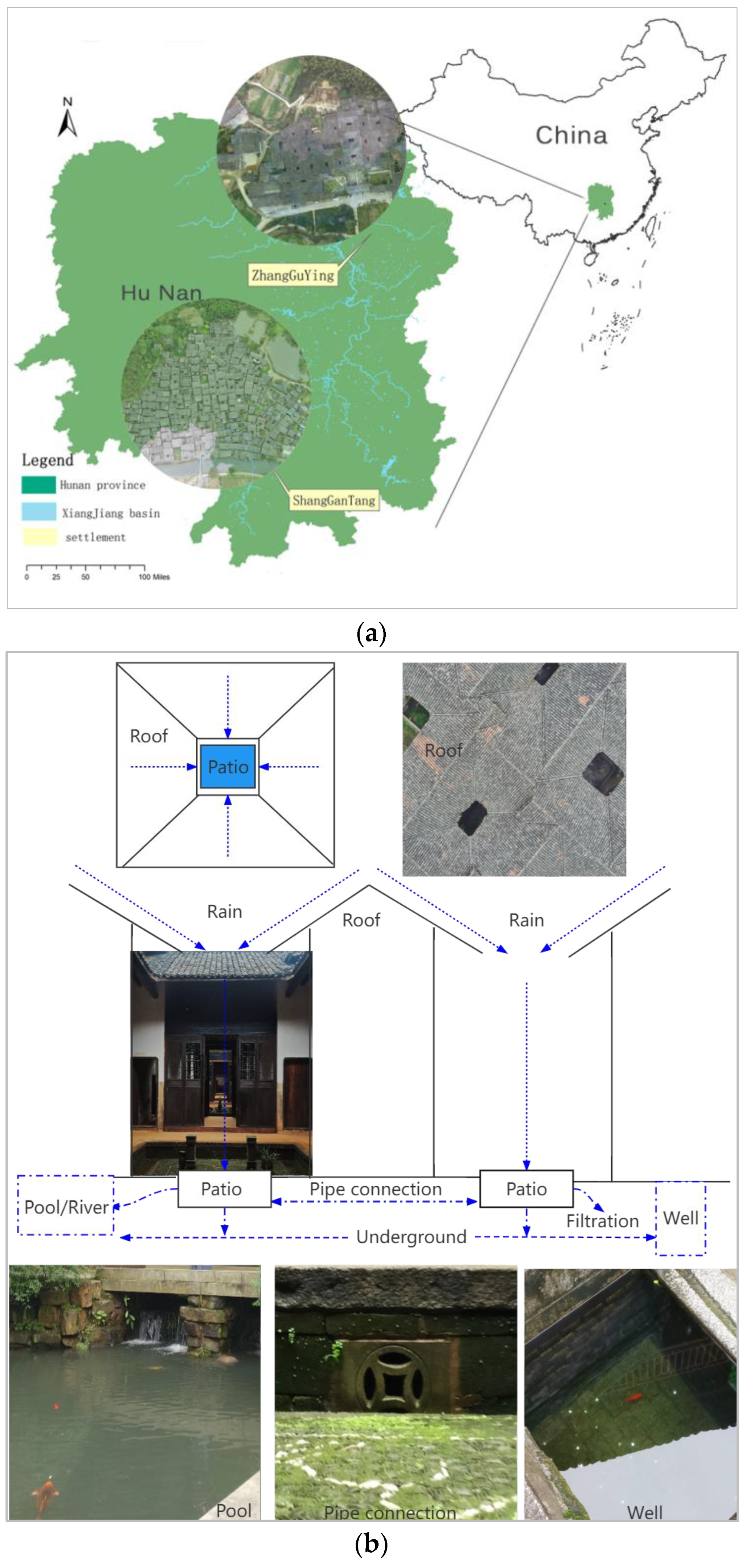
Through field investigation, on-site interview, and photogrammetry, this study collected, analyzed, and compared the basic data related to water management in two traditional settlements so as to obtain the operation mechanism of a traditional settlement water management system and further discuss the possibility of its wider application.

2.1. Study Area

The two villages involved in the research are located in Southeast China, Xiangjiang River Basin (Figure 1a).
The ZhangGuYing village of YueYang City (29°00′36″ N; 113°128′30″ E) has a population of 2169 inhabitants (data from year 2000, newer official data are not available). The ShangGanTang village of YongZhou City (25°09′09″ N; 111°10′57″ E) has a population of 1865 inhabitants (data from year 2000, newer official data are not available) are located in Hunan Province in terms of administrative division. In terms of geographical location, the two settlements are located in the upper and lower half of the Xiangjiang River Basin. They belong to the subtropical monsoon climate area, but according to the data of the local weather station, the precipitation, humidity, and annual average temperature of the two settlements are different, as shown in Table 1.
The rainwater collection and storage system mainly have three parts:
  • The rain harvesting roof
  • The patio and underground pipe connection (the patio has an average water capacity of 2.4 m3)
  • The water storage pool (The pool capacity for Z village is unavailable yet; for S village, the water storage capacity is 73.43 [10])
As we can see from Figure 1b, the rainwater was collected by the roof from 4 directions, falling down to the patio, each patio being connected by the underground pipe system, and a bigger amount of water drained into the river; less water was stored in the pool. Some part of the water after infiltration goes down (underground), and the water which was left on the patio can be used for daily purposes (for washing, for microclimate amelioration of the courtyards, etc.). Less is used for drinking, as far as the drinking water obtained from the well. Due to the traditionally used wooden construction materials of the villages, the water from the pool is also used in case of accidental fire.
The villages are located in rural landscapes, representing the organic part of the landscape, which has as its main use paddy rice production. The rice field has a totally independent water supply system called the rice canal, which is connected to the river. For the whole research area, this study will explain the function of the different parts of the water management system used in the village. The data analysis will only focus on the rain harvest part to calculate the amount of water collection and compare the two villages for the similarities and differences in water management strategies.

2.2. Tools and Models

The settlement image data was collected by DJI phantom3, and the 3D model was rendered by the Contextcapter software. Surface measurements and linear regression analysis were performed by Acute3D viewer. Topographic data were collected through Google Earth, and topographic maps and cross-sections of settlements were processed by Surfer software (Figure 2).

2.3. Data Collection and Calculation

Drone photogrammetry was performed on the two urban landscapes in the Xiangjiang River Basin, and the drone routine collection data was entered into the Contextcapture software for processing in order to obtain 3D models of the two settlements. The 3D model was then measured to obtain the catchment area of the patio and roof (Table 2). The regression analysis of the patio and roof area of the buildings showed that there was a linear correlation between the patio and roof area of the two settlements.
Combining precipitation data, the catchment area of the roof, patio, and the measured area were calculated. With data and interviews, the similarities and differences in water management mechanisms of the two settlements were further compared.
Through Surfer software and Google Earth data, the topography of the two settlements was modeled and profiled to obtain the direction of surface runoff, the topographic relief, and a spatial overview of the site.
Finally, the analysis of precipitation and water retention was combined with the logic of village planning and its related adaptive mechanisms (Figure 2).

3. Results

3.1. Regression Result

As we can see from Figure 3, the regression formula is:
Y1 = 6.3367X1 + 86.638 (ZhangGuYingP/R2)
Y2 = 3.4467X2 + 21.23 (ShangGanTangP/R1)
Y1: ZhangGuYing village rainwater harvesting roof area
Y2: ShangGanTang villages rainwater harvesting roof area
X1: ZhangGuYing village patio area
X2: ShangGanTang village patio area
The median of the patio area from 68 dwellings is 3.9 m2
Bring the median of the patio area into Equation (1):
Y1 = 111.35 m2 and Y2 = 34.67 m2
As the equations show, the two ratios of the roof catchment area to the patio area are close: in the case of ZhangGuYing (Z) 6.3367 and in the case of ShangGanTang (S) 3.4667. Both the R2 values are greater than 0, and the area of the roof and patio are positively correlated; that is, the area of the roof (rainwater harvesting) and the area of the two settlements are related to the patio (water storage) area. There is a linear correlation between the roof and the patio (Figure 3).
This is in line with the design language patterns of traditional Chinese architecture; that is, each component of the building is designed according to strict, designated proportions [41]. This design logic has two reasons: one is the standardization of traditional architectural theory, and the other is that it can be combined or adapted to local conditions. It involved adaptive adjustment of the scale and function of the landscape to different situations [42]. From the regression analysis results, we can indirectly conclude that the water management logics of the two traditional settlements are very similar. Meanwhile, the difference is obvious from Table 2: the total roof area of 34 buildings in Z village is 4242.25 m2, and in S village is 1251.05 m2. As we can see from Figure 2, the architectural design and structure of the two villages is different: the Z village design is called “DaWu” which means the members of the whole village live as a clan family in one big house. The S village is in the same clan clustering situation, but DaWu is a special form to emphasize the unity between the family members; it is reflected in the design by connecting the roof of each dwelling together. Both villages belong to the logic of clan settlement, but the architectural expression is different. This is the explanation from a cultural perspective.
More importantly, for water management purposes, here we assume that the differences are caused by the adaptation to the environment and topographical conditions of the two settlements. The hypothesis was interpreted in combination with the local interview, topography analysis, and meteorological data.

3.2. Meteorological Analysis

Rainwater amount collection
S village yearly average precipitation (roof) 1426 mm/m2 * 1251 m2 =1.784 million L
August (max): 255 mm/m2 = 0.319million L
Z village yearly average precipitation (roof) 1353 mm/m2 * 4242 m2 = 5.739 million L
August (max): 172.9 mm/m2 = 0.733 million L
Based on the average annual precipitation and the surface area of the settlements, the annual water quantity collected by the roofs of S Village is 1.784 million L, while in the Z village it is 5.73 million L. In Table 3, using the Acute3D measurement tool, we selected the study area including 34 dwellings and a part of the river that flows through the settlement as the total area, and compared the river area with the selection area of the study area.
ShangGanTang has 367 traditional dwellings in total; we selected 34 buildings, where the rain harvest function is still working, and this traditional way reusing the rainwater is still used and maintained by the villagers.
ZhanGuYing has 1062 traditional dwellings in total, due to the long-term expansion. The village mainly has three parts: DangDaMen (422,1593DC); WangJiaDuan (468,1802DC), and ShangXinWu (172,1803DC). We only choose 34 buildings, which were built in same period in the WangJIaDuan part of the village, all these buildings having similar rain harvest functions. The total area was selected through surface measurement tools. We used the 367 buildings and the river surface area, which go through the village as the selected area for ShangGanTang village (34,174 m2), and 468 building areas of WangJiaDuan part and river surface area, which go through the village as the selected area for ZhanGuYing village (16,334.39 m2). We found that the river area ratio in Z village is 6%, much smaller than that in S Village at 10%, and the precipitation in Village Z 1353mm is lower than that in S Village 1426mm, so the theoretical water collection in Z village can increase significantly more than in S Village. Combined with local interviews, the number of floods in the village was also higher in S than in Z village. For S villages, the flood control function is more important, so the patio and roof are smaller than in Z villages; thus, the meteorological analysis supported the hypothesis.

3.3. Topography Analysis: The Art of Choosing a Location

According to Figure 4, we can see that both Z and S villages are located on flat ground between hills and rivers.
In the process of the landscape development of the traditional Chinese settlement, the most important step is the positioning of the settlement [43], which can also be understood as the choice of an adequate living environment [44]. Just like in the case of painting [45], the choice of location is equivalent to the painter’s first stroke on the canvas, followed by the construction and management of the surrounding environment of the selected location, that is, landscape transformation [46].
In terms of location selection, Chinese landscape architects need to consider many factors, and they also gradually develop a systematic Feng Shui theory in the process of practice [47]. According to the positioning in Feng Shui, the most beneficial settlement location is the “Livable” position [46]. In the Chinese classical philosophy system, “qi” is divided into two kinds: Yin and Yang, which are reflected in the landscape as a mountain (Yang) and water (Yin) [48,49]. Therefore, in ancient times, Feng Shui chose the positions between mountains and rivers to build settlements [50]. From the artistic perspective, this site selection layout is conducive to borrowing scenery, that is, using mountains and rivers to create visual order and a sense of harmony [51,52]. This type of selection and location is also enlightening from the perspective of contemporary science:
1. The thermal circulation generated between the mountains and rivers meets the needs of heat dissipation and ventilation.
2. The wind direction of the monsoon climate is conducive to cooling in summer and avoiding cold air intrusion in winter.
3. Meets the needs for water use and avoids floods.
4. Uses the change of topography to create the layering of the landscape.
5. Layout of the settlement along the river to alleviate spatial and social conflicts.
6. Uses the change of topography combined with the water collection facilities for the sponge effect [10].
The location of the settlement is part of the adaptive to topography strategies. The surface runoff was considered during the settlement planning. ZhangGuYing Village is relatively flat, while ShangGanTang Village is a typical traditional Feng Shui layout, surrounded by hills on three sides and a river on one side. In this landscape setting, the planners of the traditional settlement fully considered the water management strategies.
For ShangGanTang Village, due to the proximity to the river, the river flow is high, and the surface runoff path of the mountain needs to pass through the settlement. Analyzing Figure 4, it is clearly understandable that the adjustment of the collection capacity of rainwater is low, which is conducive to preventing waterlogging. For Zhanguying Village, the altitude is lower (Table 3). The average annual precipitation is low, the surface runoff is slow, and the settlements are distributed along the two sides of the stream so that the water collection function can be maximized.

3.4. Summary

It can be seen that, according to different environments, the water collection and storage of each building in different settlements has the same logic but with different capacities. The water collection volume is adjusted according to the precipitation, the size of the river, and the topographic characteristics of the landscape. In other words, the strategies are the same but adapted to the specific environment. (Table 4.)
For Z village, the precipitation is 1353mm, lower than S village, and the river size is 1125.23 m2. It is also smaller than S village, as the highest point is around 150 m, lower than S village; thus, the Z village adjusted the roof size, maximizing the rainwater collection function.
In addition to the roof–patio rainwater harvesting system based on residential buildings, the location of the settlement also plays an important role in water management. Taking ShangGanTang as an example, the site selection of the settlement conforms to the principle of the traditional Feng Shui theory: the settlement faces the water/river and has the mountain at its back [53]. Such a site selection can combine the water collection and storage systems of single buildings to participate in the water cycle during the formation of precipitation and runoff and has a similar function of regulating water bodies as sponge cities [54].
The integrity of ZhangGuYing Village is more obvious. The roof and patio are linked to each other, which can maximize the collection and storage of rainwater. In addition, the patio and the stream are also connected, and there is a water outlet to control the flow and thus actively adjust the storage capacity. (Figure 4)

4. Discussion: Systematic Water Management Strategies and Sustainable Trends

From the above analysis, we can find that the water management strategies of the two villages are logically similar.
From the point of view of landscape pattern, the two traditional settlements are represented by three parts: dwellings–settlement–landscape (surrounding environment) in terms of water management. The three parts are independent but interconnected. It can be said that the traditional settlement uses landscaping and architecture to achieve less interference with the natural surface runoff and underground runoff.
These functions can be interpreted from an ecological perspective today, but in traditional Chinese society, they are better interpreted in terms of culture, practice, and meaning [55].
According to traditional Chinese culture, man, as a part of nature [56], also has natural attributes [57], while Feng Shui in the traditional landscape literally means Feng: wind (air flows) and Shui: water flows [58]. Air and water are also common fluids in nature, with the attributes of circulation and movement. On the human side, it is more important to enable people and culture to flow continuously, like wind and water. This makes the Chinese traditional water management strategy more disseminated and sustainable at the cultural level [59,60].
In other words, in traditional society, the sustainability of material resources is also culturally combined with the trend of material sustainability. This sustainable strategy has an important impact on today’s material resources and spiritual culture. What human beings need is not only the sustainable demand for resources and materials but also the support of sustainable ideas and culture rooted in human consciousness beyond resources and materials.

5. Conclusions

This research proved the importance of the Chinese traditional cultural heritage in rainwater management through the design of the settlement and dwelling architecture (structure, form, and size). From a heritage point of view, sustainable water management strategies also have their cultural roots in the local community. Some future studies are still needed, in order to focus on some practical issues, such as the contemporary adaptabilities of traditional rain harvesting methodologies from a global perspective. The new challenges of climate change and urban sustainability raise the importance of such traditional methods in the collection and use of rainwater, especially in the urban environment. In a European context, there are similar urban and landscape structural systems, which can be improved using the oriental traditions. This is expected to mitigate, among other positive effects, the urban flooding from climate change as well.

Author Contributions

Conceptualization, N.D. and A.F.; methodology, N.D.; software, J.Y.; validation, A.F., N.D. and M.v.d.T.; formal analysis, N.D.; investigation, P.L.; resources, N.D.; data curation, M.v.d.T.; writing—original draft preparation, N.D.; writing—review and editing, N.D.; visualization, N.D.; supervision, M.v.d.T. and A.F.; project administration, N.D.; funding acquisition, N.D. and A.F. All authors have read and agreed to the published version of the manuscript.

Funding

This research received no external funding.

Institutional Review Board Statement

Not applicable.

Informed Consent Statement

Informed consent was obtained from all subjects involved in the study.

Conflicts of Interest

The authors declare no conflict of interest.

References

  1. Anagnostopoulos, G.L. Traditional settlements in the landscape. Plan. Outlook 1977, 20, 3–5. [Google Scholar] [CrossRef]
  2. Wirth, L. Urbanism as a Way of Life. Am. J. Sociol. 1938, 44, 1–24. [Google Scholar] [CrossRef] [Green Version]
  3. Beatley, T.; Timothy, B.; Manning, K. The Ecology of Place: Planning for environment, Economy, and Community; Island Press: Washington, DC, USA, 1997. [Google Scholar]
  4. Meggers, B.J. Environmental Limitation on the Development of Culture. Am. Anthr. 1954, 56, 801–824. [Google Scholar] [CrossRef]
  5. Priscoli, J.D. Water and civilization: Using history to reframe water policy debates and to build a new ecological realism. Water Policy 2000, 1, 623–636. [Google Scholar] [CrossRef]
  6. Mays, L. (Ed.) Ancient Water Technologies; Springer Science & Business Media: Berlin, Germany, 2010. [Google Scholar]
  7. Grof, S. (Ed.) Ancient Wisdom and Modern Science; SUNY Press: Albany, NY, USA, 1984. [Google Scholar]
  8. Angelakis, A.N.; Koutsoyiannis, D.; Tchobanoglous, G. Urban wastewater and stormwater technologies in ancient Greece. Water Res. 2005, 39, 210–220. [Google Scholar] [CrossRef] [PubMed]
  9. Mays, L.W. Water technology in ancient Egypt. In Ancient Water Technologies; Springer: Dordrecht, The Netherlands, 2010; pp. 53–65. [Google Scholar] [CrossRef]
  10. Fekete, A.; Dong Ge, N. Sustainable Water Management Model as Landscape Heritage in Shang Gan Tang Village, China. IOSR J. Eng. (IO-SRJEN) 2019, 10, 2250–3021. Available online: www.iosrjen.org (accessed on 23 May 2020).
  11. Rapoport, A. Environmental quality, metropolitan areas and traditional settlements. Habitat Int. 1983, 7, 37–63. [Google Scholar] [CrossRef]
  12. Gao, J.; Wang, R.; Huang, J. Ecological engineering for traditional Chinese agriculture—A case study of Beitang. Ecol. Eng. 2015, 76, 7–13. [Google Scholar] [CrossRef]
  13. Tang, Y.-T.; Chan, F.K.S.; O’Donnell, E.; Griffiths, J.; Lau, L.; Higgitt, D.; Thorne, C. Aligning ancient and modern approaches to sustainable urban water management in China: Ningbo as a “Blue-Green City” in the “Sponge City” campaign. J. Flood Risk Manag. 2018, 11, e12451. [Google Scholar] [CrossRef]
  14. Huang, P.C. The Peasant Family and Rural Development in the Yangzi Delta, 1350–1988; Stanford University Press: Redwood City, CA, USA, 1990. [Google Scholar]
  15. Chang, K.-S. China’s rural reform: The state and peasantry in constructing a macro-rationality. Econ. Soc. 1992, 21, 430–452. [Google Scholar] [CrossRef] [PubMed]
  16. Perkins, D.H. Agricultural Development in China, 1368–1968; AldineTransaction: Piscataway, NJ, USA, 2013. [Google Scholar]
  17. Wang, C.; Huang, B.; Deng, C.; Wan, Q.; Zhang, L.; Fei, Z.; Li, H. Rural settlement restructuring based on analysis of the peasant household symbiotic system at village level: A Case Study of Fengsi Village in Chongqing, China. J. Rural Stud. 2016, 47, 485–495. [Google Scholar] [CrossRef]
  18. Tundisi, J.G. Water resources in the future: Problems and solutions. Estud. Avançados 2008, 22, 7–16. [Google Scholar] [CrossRef] [Green Version]
  19. Lepofsky, D. The Past, Present, and Future of Traditional Resource and Environmental Management. J. Ethnobiol. 2009, 29, 161–166. [Google Scholar] [CrossRef]
  20. Yang, L.; Liu, P. The inheritance and its evaluation system of traditional village culture: A case study of traditional village in Hunan province. Econ. Geogr. 2017, 37, 203–210. [Google Scholar]
  21. Thomas, T. Domestic water supply using rainwater harvesting. Build. Res. Inf. 1998, 26, 94–101. [Google Scholar] [CrossRef]
  22. Li, L.; Zhang, G. Different purpose of rainwater catchment in China and their environmental effects. In Proceedings of the 8th International Conference on Rainwater Catchment Systems, Tehran, Iran, 21–25 April 1997. [Google Scholar]
  23. Mou, H. Rainwater utilization for sustainable development in north China. Waterlines 1995, 14, 19–21. [Google Scholar] [CrossRef]
  24. Arnold, P.; Cullis, A. Rainwater harvesting. In The Collection of Rainfall and Runoff in Rural Areas; Intermediate Technology Publ.: London, UK, 1986. [Google Scholar]
  25. Wisser, D.; Frolking, S.; Douglas, E.M.; Fekete, B.M.; Schumann, A.H.; Vörösmarty, C.J. The significance of local water resources captured in small reservoirs for crop production—A global-scale analysis. J. Hydrol. 2010, 384, 264–275. [Google Scholar] [CrossRef] [Green Version]
  26. Singh, O.; Turkiya, S. Assessing Potential for Rooftop Rainwater Harvesting:An Option for Sustainable Rural Domestic Water Supply in Arid Region of Haryana. J. Rural Dev. 2017, 36, 49. [Google Scholar] [CrossRef]
  27. Patel, U.R.; Patel, V.A.; Balya, M.I.; Rajgor, H.M. Rooftop rainwater harvesting (RRWH) at SPSV Campus, Visnagar: Gujarat—A case study. Int. J. Res. Eng. Technol. 2014, 3, 821–825. [Google Scholar]
  28. Barthwal, S.; Chandola-Barthwal, S.; Goyal, H.; Nirmani, B.; Awasthi, B. Socio-economic acceptance of rooftop rainwater harvesting—A case study. Urban Water J. 2013, 11, 231–239. [Google Scholar] [CrossRef]
  29. Palla, A.; Gnecco, I.; Lanza, L. Non-dimensional design parameters and performance assessment of rainwater harvesting systems. J. Hydrol. 2011, 401, 65–76. [Google Scholar] [CrossRef]
  30. Asadieh, B.; Krakauer, N.Y. Impacts of Changes in Precipitation Amount and Distribution on Water Resources Studied Using a Model Rainwater Harvesting System. JAWRA J. Am. Water Resour. Assoc. 2016, 52, 1450–1471. [Google Scholar] [CrossRef]
  31. Li, S.; Ding, K.; Ding, A.; He, L.; Huang, X.; Ge, Q.; Fu, C. Change of extreme snow events shaped the roof of traditional Chinese architecture in the past millennium. Sci. Adv. 2021, 7, eabh2601. [Google Scholar] [CrossRef] [PubMed]
  32. Kazak, J.K.; Dąbrowska, J.; Bednarek, A. Stormwater Management in Urban and Rural Areas. Water 2022, 14, 3488. [Google Scholar] [CrossRef]
  33. Fekete, A.; Herczeg, Á.; Ge, N.D.; Sárospataki, M. Participatory Landscape Design and Water Management—A Sustainable Strategy for Renovation of Vernacular Baths and Landscape Protection in Szeklerland, Romania. Land 2022, 11, 95. [Google Scholar] [CrossRef]
  34. Zhou, W.; Matsumoto, K.; Sawaki, M. Understanding the traditional wisdom of harvesting rainwater in household yards: Construction and rainwater usage patterns of settlement water cellars in semi-arid China. J. Asian Arch. Build. Eng. 2022, 1–13. [Google Scholar] [CrossRef]
  35. Song, X.; Mulder, K.; Frostell, B.; Ravesteijn, W.; Wennersten, R. Transition in public participation in Chinese water management. In Proceedings of the Institution of Civil Engineers-Engineering Sustainability; Thomas Telford Ltd.: London, UK, 2011; Volume 164. [Google Scholar]
  36. Zheng, X.Y. The ancient urban water system construction of China: The lessons from history for a sustainable future. Int. J. Glob. Environ. Issues 2015, 14, 187. [Google Scholar] [CrossRef]
  37. Wu, C.; Qiao, M.; Wang, S. Enlightenment from ancient Chinese urban and rural stormwater management practices. Water Sci. Technol. 2013, 67, 1474–1480. [Google Scholar] [CrossRef] [PubMed]
  38. Xu, Y.-S.; Shen, S.-L.; Lai, Y.; Zhou, A.-N. Design of sponge city: Lessons learnt from an ancient drainage system in Ganzhou, China. J. Hydrol. 2018, 563, 900–908. [Google Scholar] [CrossRef]
  39. Dong, R.; Zhang, X.; Li, H. Constructing the Ecological Security Pattern for Sponge City: A Case Study in Zhengzhou, China. Water 2019, 11, 284. [Google Scholar] [CrossRef] [Green Version]
  40. Meteorological Data of the Two Villages. Available online: http://data.cma.cn/data/weatherBk.html (accessed on 3 February 2022).
  41. Cody, J.W.; Steinhardt, N.S.; Atkin, T. Nancy Shatzman Steinhardt, and Tony Atkin. In Chinese Architecture and the Beaux-Arts; University of Hawaii Press: Honolulu, HI, USA, 2017. [Google Scholar] [CrossRef] [Green Version]
  42. Li, A.I. A Shape Grammar for Teaching the Architectural Style of the Yingzao Fashi. Ph.D. Thesis, Massachusetts Institute of Technology, Cambridge, MA, USA, 2001. [Google Scholar]
  43. Bruun, O. Fengshui in China: Geomantic Divination between State Orthodoxy and Popular Religion; University of Hawaii Press: Honolulu, HI, USA, 2003. [Google Scholar]
  44. Marafa, L. Integrating natural and cultural heritage: The advantage of feng shui landscape resources. Int. J. Herit. Stud. 2003, 9, 307–323. [Google Scholar] [CrossRef]
  45. Zhang, L. Nature and landscape in the Chinese tradition. In New Perspectives on the Research of Chinese Culture; Springer: Singapore, 2013; pp. 1–15. [Google Scholar]
  46. Han, K.-T. Traditional Chinese Site Selection-Feng Shui: An Evolutionary/Ecological Perspective. J. Cult. Geogr. 2001, 19, 75–96. [Google Scholar] [CrossRef]
  47. Xu, P. Feng-Shui: A Model for Landscape Analysis; Harvard University: Cambridge, MA, USA, 1990. [Google Scholar]
  48. Zhang, Y.H.; Rose, K. A Brief History of qi; Paradigm Publications: Boulder, CO, USA, 2001. [Google Scholar]
  49. Wang, R.R. Dong Zhongshu’s transformation of Yin-Yang theory and contesting of gender identity. Philos. East West 2005, 55, 209–231. [Google Scholar] [CrossRef]
  50. Li, X.-D. Meaning of the Site: A Holistic Approach towards Site Analysis on Behalf of the Development of a Design Tool Based on a Comparative Case-Study between FengShui and Kevin Lynch’s System; Technische Universiteit Eindhoven: Eindhoven, The Netherlands, 1993; 236 p. [Google Scholar]
  51. Xu, J. A Framework for Site Analysis with Emphasis on Feng Shui and Contemporary Environmental Design Principles; Virginia Polytechnic Institute and State University: Blacksburg, VA, USA, 2003. [Google Scholar]
  52. Bruun, O. An Introduction to Feng Shui; Cambridge University Press: Cambridge, UK, 2008. [Google Scholar] [CrossRef]
  53. Lee, Y.-T.; Yang, H.; Wang, M. Daoist Harmony as a Chinese Philosophy and Psychology. Peace Confl. Stud. 2009, 16, 68–81. [Google Scholar] [CrossRef]
  54. Qi, Y.; Chan, F.K.S.; Thorne, C.; O’Donnell, E.; Quagliolo, C.; Comino, E.; Pezzoli, A.; Li, L.; Griffiths, J.; Sang, Y.; et al. Addressing Challenges of Urban Water Management in Chinese Sponge Cities via Nature-Based Solutions. Water 2020, 12, 2788. [Google Scholar] [CrossRef]
  55. Lomas, J.D.; Xue, H. Harmony in Design: A Synthesis of Literature from Classical Philosophy, the Sciences, Economics, and Design. She Ji J. Des. Econ. Innov. 2022, 8, 5–64. [Google Scholar] [CrossRef]
  56. Li, C. The Confucian ideal of harmony. Philos. East West 2006, 56, 583–603. [Google Scholar] [CrossRef]
  57. Fang, C.; Wang, Z.; Liu, H. Beautiful China Initiative: Human-nature harmony theory, evaluation index system and application. J. Geogr. Sci. 2020, 30, 691–704. [Google Scholar] [CrossRef]
  58. Cooper, D.E. Daoism, nature and humanity. R. Inst. Philos. Suppl. 2014, 74, 95–108. [Google Scholar] [CrossRef]
  59. Li, F.; Cook, S.; Geballe, G.T.; Burch, W.R., Jr. Rainwater harvesting agriculture: An integrated system for water management on rainfed land in China’s semiarid areas. AMBIO A J. Hum. Environ. 2000, 29, 477–483. [Google Scholar] [CrossRef]
  60. Catalani, A. Water & heritage: Material, conceptual and spiritual connections. Int. J. Heritage Stud. 2016, 23, 174–176. [Google Scholar] [CrossRef]
Figure 1. (a) Location of the two villages in Xiangjiang River Basin, Southeast China. (b) The water collection system used in the villages.
Land 11 02107 g001
Figure 2. Conceptual framework of the research process.
Land 11 02107 g002
Figure 3. The linear regression of roof and patio surface areas of the two villages.
Land 11 02107 g003
Figure 4. The topography and cross-section of (a) ShangGanTang village; (b) ZhangGuYing village.
Land 11 02107 g004
Table 1. Meteorological data of the two villages.
Annual Average
(1981–2010)
PrecipitationTemperatureHumidity
ZhangGuYing1353 mm−5.9–39.2 °C77%
ShangGanTang1426 mm−5.2–40.3 °C78% 1
1 Meteorological Data website [40].
Table 2. The table of the 3D model water catchment area measurement.
Patio1
(m2)
Roof1
(m2)
P/R1
(ShangGanTang)
Patio2
(m2)
Roof2
(m2)
P/R2
(ZhangGuYing)
12.7836.580.07599783.83102.150.0374939
5.9630.730.19394732.45112.110.0218535
1.413.380.10463387.5127.190.0589669
42.8333.440.08462921.2274.570.0163605
4.6732.960.141686912.72105.620.1204317
61.418.90.07407412.5490.090.028194
4.1125.970.15825955.79107.590.0538154
2.7741.970.06599955.51124.050.0444176
3.6123.920.15091974.69149.820.0313042
104.5442.820.10602523.24116.580.0277921
4.5638.980.11698316.64140.970.0471022
126.664.610.10215145.75158.770.0362159
131.6526.110.06319426.45182.720.0352999
3.3232.220.10304166.22140.330.0443241
7.6567.930.112615949.62277.820.1786049
162.1634.760.06214043.83104.360.0366999
2.0228.810.07011452.79126.120.0221218
181.9634.410.05696027.75137.150.0565075
2.527.920.08954159.62172.150.0558815
3.1836.980.08599248.49148.070.0573377
1.1127.070.04100483.9996.760.041236
223.1824.530.12963723.93105.750.0371631
6.7136.030.18623375.58122.950.0453843
242.3644.830.05264333.3197.230.034043
255.9750.870.1173582.2467.910.0329848
2.4925.910.09610192.6880.230.033404
9.1242.620.2139847138.040.0507099
282.7427.760.09870328.67163.410.0530567
5.0935.40.14378538.53149.180.0571792
302.8530.740.09271312.72123.340.0220529
1.833.370.05394070.5989.850.0065665
5.129.060.1754995.88106.790.0550613
5.0926.370.19302245.85105.390.0555081
3428.22123.090.22926316.4497.190.066262
SUM151.51251.050.1210983224.064242.250.0528163
Average4.455882436.7955880.11302356.59124.772060.0470982
Table 3. The table of 3D model water catchment area measurement.
Total Area (Selection) River AreaRiver Area RatioMax Altitude
ZhangGuYing16,334.39 m21125.23 m26%150 m
ShangGanTang34,174 m23745.28 m210%280 m
Table 4. The comparative analysis of two village.
PrecipitationRiver SizeTopography
(Height)
Water Collection Capacity
ZhangGuYing1353 mm1125.23 m2150 m5.739 million L
ShangGanTang1426 mm3745.28 m2280 m1.784 million L
Publisher’s Note: MDPI stays neutral with regard to jurisdictional claims in published maps and institutional affiliations.

