1. Introduction
Against the background of industrialization and urbanization, to mitigate environmental risks, new types of cities with spatial and functional polarization characteristics have emerged in some developed countries. This tendency, which is termed “polycentralization”, can be traced back to the mid-nineteenth century, primarily in the developed world, especially in North American metropolitan areas and European metropolitan areas [
1]. Scholars have developed a large body of knowledge regarding the pervasive phenomenon of urban polycentric development, but such studies, in the context of developing countries, are still in their exploratory stages. As industrialization and urbanization accelerated in China, populations became clustered in urban centers in the search for better infrastructure and more employment opportunities, and a series of industrial development zones emerged in suburban areas. As a result, urban diseases, such as dense urban centers, employment and housing imbalances, and urban congestion, have emerged [
2]. To solve this problem, some scholars began to introduce polycentrism into China in an attempt to alleviate the expansion problems in the core areas of large cities by promoting the evolution of the internal urban space structure from a single center to a polycentric structure. Since the 1990s, many Chinese cities have experienced dispersion from the city center and the formation of new agglomerations in suburban development zones, guided by a polycentric development strategy. Thus, empirical studies of the dynamics of polycentric cities should be more focused on the specific contexts of developing countries, given that a distinct process of urban expansion and institutional arrangement might be reflected in the characteristics of urban spatial structure transformation. China’s phenomenal urban transformation in recent years presents an essential and valuable case among developing countries and transitional economies for such studies.
Scholars have noted that the spatial development model of the city evolves from different development starting points, has a path-dependent development trajectory, and is shaped over time by a combination of many structural driving forces and unexpectedly emerging factors [
3,
4]. The development pattern of a polycentric space is proposed during the development of urbanization and urban expansion. On the macro-level, the urban expansion process is the spatial expansion of urban land use, while on the micro-level, it is a process of the transformation of different types of agricultural land into urban construction land. Polycentric models, on the metropolitan or regional level, present with many different forms [
5]. There are three stages from the perspective of dynamic development. The more primitive stage is characterized by the spatially balanced distribution of cities of similar sizes, whereas the higher-level stage is represented by the urban agglomeration area enclosing small centers. Regions can have both characteristics of the two above-mentioned development stages [
6]. Champion summarized three typical polycentric development models from the perspective of urban spatial evolution: the centrifugal model, combined model, and fusion model [
7]. Zhou believed that the spatial structure of polycentric cities is typically a point-axis model or a decentralized group model [
8], while Wei and Zhao claimed that there are four types of structures of polycentric cities—loose, suburbanized, extremely uneven, or stretched compact polycentric structures—based on their differences in spatial location and population spatial distribution [
9]. Many theoretical models have been used to explain the evolution of polycentric formation. Mainly, “agglomeration-decentralization” [
10,
11] and “governmental-market-social forces” frameworks [
12,
13] are used to explain the spatial evolution mechanism. In the former case, the localized social context is often simplified and neglected, reducing its explanatory power with respect to spatial evolution. In the latter case, although the social complexity of spatial evolution is taken into account, insufficient attention is paid to the changes in various forces affecting spatial evolution, and a relatively complete theoretical analytical framework is lacking [
14]. Currently, the study of polycentricity is becoming increasingly enriched, ranging from morphology to function and further resulting in governance polycentricity. The fields of urban geography and morphology focus more on the morphological and functional characteristics of polycentricity, while on the level of polycentric governance, they draw on theoretical perspectives, such as public management and institutional economics. The four-level analytical framework proposed by Williamson as an institutional tool of analysis is only used to qualitatively analyze the direct binding role of policy design and the decision making of actors in polycentric governance. Relying on the rational formulation of public policies and institutional frameworks to alleviate the contradictory relationships between different spaces within the city may be one of the important research directions in the field of social geography in the future [
15]. Although there have been a large number of studies on the spatial reconfiguration process of polycentric cities, most of them focus on the measurement of morphological polycentricity and functional polycentricity, while there are relatively few studies on the organizational model and evolutionary logic of urban polycentricity from the perspective of governance. At the same time, there is a relative lack of exploration of the localized theoretical framework and evolutionary formation in the specific context of China. Therefore, there is an urgent need for future polycentric research to establish a polycentric city analytical framework that is suitable for the context of transitional China and to effectively integrate existing polycentric theory and planning practice with multi-level polycentric governance [
16].
However, relatively less empirical research has been performed to examine whether the internal urban space structure truly realizes evolution from a single center to a polycentric form. How can its formation mechanism, functional layout and spatial characteristics be measured? Moreover, controversy exists concerning the government roles and the emerging market and their interactions in the Chinese restructuring process. This study aims to construct a multidimensional analytical framework to explore the evolution and spatial characteristics of polycentric cities in China from the perspectives of the institutional environment, governance structure and resource allocation, providing an alternative perspective on the spatial development optimization of polycentric cities. Meanwhile, since most studies on polycentric cities have focused on large cities, such as Beijing, Shanghai and Guangzhou, and less attention has been paid to general provincial capitals and relatively mid-sized cities, the study takes Hangzhou as a typical example to supplement empirical research on the roles of the government and market in polycentric formation.
The paper is structured as follows: In the next section, a detailed analytical framework based on the institutional environment, governance structure and resource allocation is described. This is followed by an overview of the sample area and a discussion of the data in
Section 3, after which the results are presented in
Section 4. The fifth section discusses the formation of the polycentric setting in Hangzhou and, finally, summarizes the results and draws conclusions.
2. Theoretical Framework
Under the influences of multiple factors, urban areas with multiple decision-making centers are functionally independent, and the flow and spatial allocation of resource elements are realized through mechanisms such as competition and cooperation. Many studies have found that the macro-institutional environment and micro-resource allocation have significant impacts on urban polycentric development [
17,
18]. The new institutional economics represented by Williamson provides a theoretical basis for the different levels of factors affecting the mechanism of urban polycentric development [
19]. This analytical framework includes four levels: the social foundation, institutional environment, governance structure and resource allocation. The first level, the social foundation, includes informal institutions such as social norms, customs and traditional aspects, such as religion. The informal institutions on this level are spontaneous and evolve relatively slowly
1. This level has a widespread and far-reaching influence on the long-term operational characteristics of urban economic systems [
20]. The second level is referred to as the institutional environment, and it mainly comprises the formal rules of human society, such as constitutions, laws and property rights. Based on the constructed order, good formal rules make it possible for humankind to achieve urban economic efficiency and provide the macro-foundation for the formation of the polycentric characteristics of cities. The third level is the governance structure. The design of a proper governance structure to achieve optimal polycentric governance in urban areas is at the heart of this kind of analysis. The fourth level is resource allocation. The market plays a significant role in the development of polycentric urban areas.
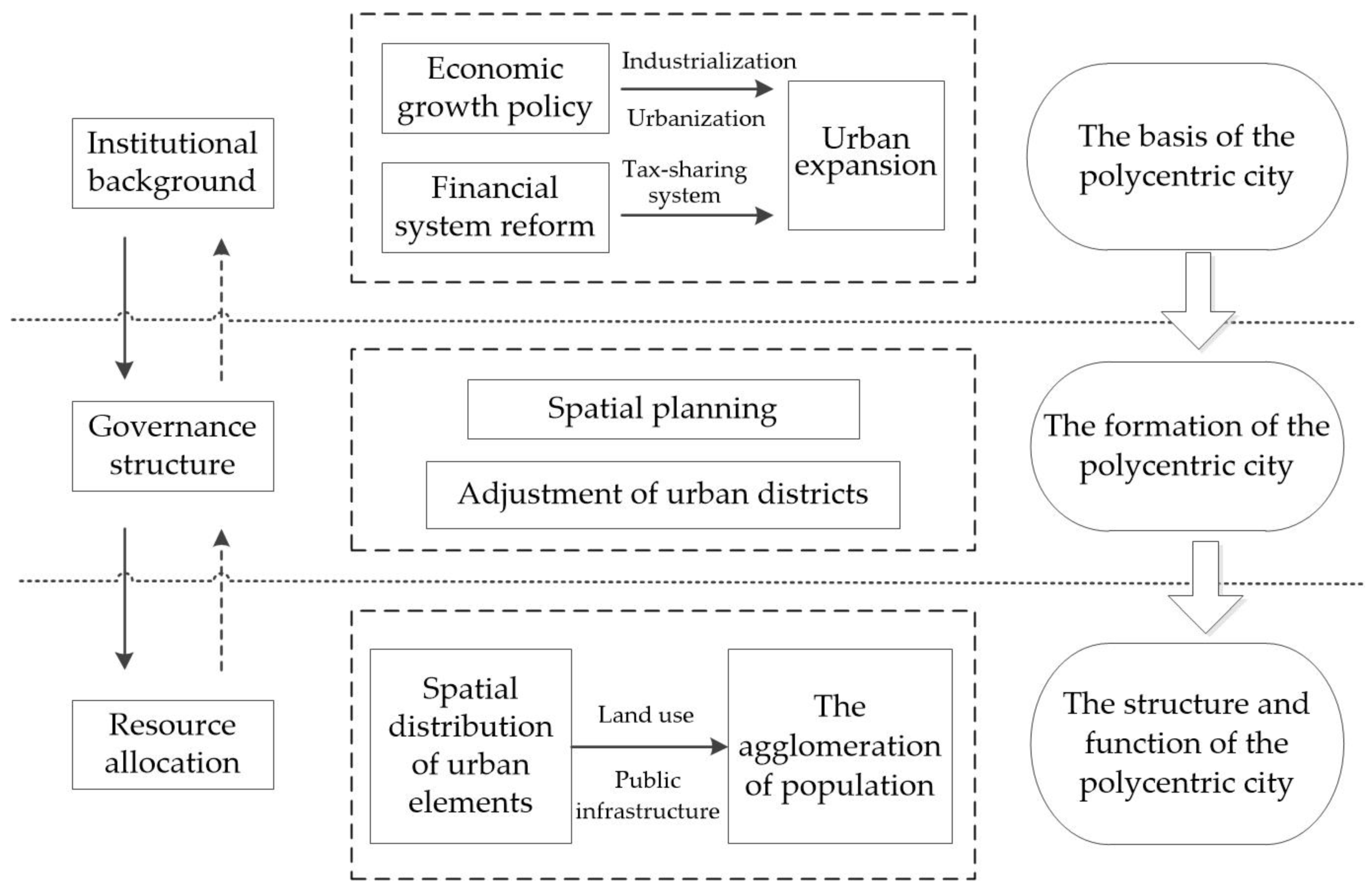
The interactions on different levels and the roles of behavioral subjects on each level are as follows. Firstly, examining the utilization of land resources within a city provides an information-based reference for municipal polycentric development on the resource allocation level. The development and extension of the city result from government decisions and guidance, and these can produce feedback for information judgement through accurate mathematical calculations. Secondly, because the resource allocation level of polycentric urban areas is determined by the specific governance structure, the information generated on the resource allocation level is transmitted upwards to provide feedback on the question of whether the existing governance structure needs to change to support urban polycentric development. The appropriate governance structure for achieving reasonable municipal polycentric development results must be determined by local governments through certain policy tools. Furthermore, the demand for changes in the governance structure may lead to a demand for relevant formal changes in the institutional environment, because the current urban polycentric form defines the rules of the game that form a specific governance structure. Finally, changes in the formal system will also create new institutional constraints and drivers influencing the choice of existing governance structures and the allocation of urban resources, indirectly affecting urban polycentric development. The three levels interact with each other, and behavioral subjects guide the policy design and decisions, which ultimately affect the resulting performance of urban polycentric development. The result of urban polycentric development, in reality, also provides feedback on the design decisions of the subjects, which promotes its improvement on all levels.
The development of the urban polycentric form in China is influenced by numerous factors, such as macroeconomic constraints, government-driven factors and spontaneous market factors [
21,
22]. To link the institutional exogenous variables (such as planning policies) that affect polycentric development with micro-resource allocation and to study the formation mechanism and evolutionary process of the characteristics of the urban polycentric form, we draw on Williamson’s ideas of social analysis [
19] and construct a “three-level” theoretical framework for analyzing the urban polycentric form. This framework assumes that polycentric development is influenced by the institutional environment, governance structure and resource allocation on three levels (see
Figure 1).
Firstly, a series of elementary institutions emerging in China provide the macro-foundation for the formation of the urban polycentric form. Since the reform and opening up of the country, the urban-rural dual system has begun to collapse, and industrialization and urbanization have become the primary approaches used by China to promote rapid economic growth [
23,
24]. This means that the rural population, capital and industries continue to gather in cities, resulting in urban expansion and the emergence of urban agglomeration. As the population density continues to rise, the spatial structure of the city gradually shows a polycentric development trend. The convenience of the commercial center and the government’s real-estate-development-oriented infrastructure means that the commercial subcenter of the old city and the new suburbs become the main areas of the city’s subcenter [
25]. Meanwhile, the reform of the tax-sharing system, initiated in 1994, led to a decline in fiscal revenues without changing the obligations of the local government, which forced them to search for new methods of fiscal balance. Through the incentive of land transfer finance, local governments obtain land transfer fees through land expropriation and transfer and then attract investment as a way of operating the city, forming a city expansion model of “development through the land”. This model has caused the focus of cities’ development to expand to the suburbs. The spatial structure characteristics of urban land utilization show that industrial land has been extensively expanded, and commercial and residential land has been developed at a high density, which is an important factor in the emergence of polycentric cities [
26].
Secondly, the governance structure level refers to the numerous rules selected by a city to achieve polycentric development, or it can simply be understood as policy tools for organizing and managing polycentric cities, such as urban planning and zoning adjustment. To realize the goal of urban-rural integration, local governments have gradually replaced the previous hierarchical planning model with a polycentric balanced urban plan. For example, the urban planner in Nanjing began to focus on the connections between urban and rural areas, suburban towns and the development of other growth poles [
27]. Local governments of metropolitan regions generally include satellite cities and central towns in the suburbs in urban polycentric systems, which they regulate through urban spatial planning and metropolitan planning, and they supplement this with the planning of transportation infrastructure, such as subways, to ensure convenient access between multiple centers [
28]. Furthermore, local governments have become a polycentric operational feature of Chinese cities through planning policies that aim to develop new cities and districts in the suburbs for land finance and investment promotion [
11,
21]. It can be seen that this decentralized governance structure is an important factor in the polycentric form of the city.
Finally, the resource allocation hierarchy reflects the polycentric land use change in the city, which can serve as an indicator of the performance level of polycentric operation in the city. Generally, as a supplier of local public goods, the local government is the main body of urban polycentric development and is closely related to human activity aiming towards urban sustainability. On this level, resources and their allocation mechanisms (such as market prices) become important factors affecting the polycentric shape and functional layout of cities. In China’s polycentric cities, real estate prices and commuting costs on different center levels are often inversely proportional. Specifically, real estate prices in the central area are high, while commuting costs are relatively low. Conversely, subcenter real estate prices are relatively low, but commuting costs are higher. The influences of these two factors on the size of the city and the polycentric structure have attracted attention and fostered discussion among scholars [
29,
30]. In addition, public infrastructure and other spatial elements have positive externalities, and their distribution aggravates the agglomeration of the population to a certain extent, thereby affecting the development of different urban centers.
China’s urban policy is land-based and growth-oriented, with the natural conditions, local economies and administrative systems being deeply embedded in the spatial development of cities [
31]. This analytical framework focuses on the social complexity of polycentric spatial formation from a social geography perspective and also analyzes the internal factorization that influences spatial evolution. Using this framework in the specific context of transitional China, urban polycentric areas are evaluated comprehensively on the three levels of the institutional environment, governance structure and resource allocation, avoiding the isolation of polycentric urban areas on any specific level. This analytical framework not only clarifies the relationship of mutual influence between the three levels but also considers the impacts of the feedback mechanisms of different levels on urban polycentric performance. Based on the assumptions and logic of the analysis of the discrete levels, we further refine and discuss each level according to the overall logic of this analytical framework and establish a theoretical basis for the subsequent evaluation of the implementation performance of Hangzhou City’s polycentric development.
4. The Evolution of a Polycentric Spatial Structure: The Case of Hangzhou
4.1. The Influence of the Macro-Context on the Polycentric Formation
Since its reform and opening up, China has begun to accelerate the process of industrialization and urbanization. To encourage local governments to attract investment and promote economic growth, the central government has delegated a series of economic management powers, such as land development, to local governments [
33]. With the reform of the tax-sharing system, initiated by the central government in 1994, local governments were given more authority. Thus, they began to rely on extrabudgetary income sources, such as land transfer fees, thereby forming incentive preferences for the maximization of land finance [
34] and obtaining most of the land value-added revenue generated by land conversion. This land income distribution pattern has caused many local governments to rely on the prosperity of the real estate industry and steadily rising housing prices to continuously expand the city. The institutional background described above has played a positive role in Hangzhou’s urban expansion and polycentric formation, which is reflected in the following aspects on the macro-level.
Firstly, in the context of the tax-sharing system, the government of Hangzhou actively engaged in land urbanization and applied land transfer fees to urban construction while attracting investment. For this reason, the Hangzhou government strictly controls the primary land transfer market and obtains substantial land transfer income through a strategy of selling commercial and residential land at high prices and selling industrial land at low prices, giving it one of the highest degrees of financial dependence on land among the cities in China. To maximize the benefits of land transfer, the Hangzhou government established a land reserve system in 1996. The land reserve center is responsible for providing preliminary approval for the conversion of agricultural land, land acquisition and land servicing, such as complete infrastructure for water, electricity and gas supplies and other preliminary developments. After the Land Reserve Center reserves the newly added construction land, it will increase or decrease the supply of land in a timely manner according to the need for market regulation so as to sell the land at a “satisfactory” price. In this way, the Hangzhou government utilizes its monopoly of the primary market for newly created construction land. In addition, Hangzhou uses a large amount of state-owned construction land as collateral to finance local urban infrastructure investment and construction. The established land reserve system has played a significant role in this process.
Secondly, the reform of the urban housing system directly contributed to population increases and real estate market development in Hangzhou. Due to its status as the provincial capital and its unique urban landscape (e.g., the status of the West Lake as a world cultural heritage), Hangzhou has been able to attract a large population, which has promoted its booming real estate market. Furthermore, increasing investment, especially foreign investment, brings residential demands, allowing Hangzhou to establish its own identity, with an excellent landscape to attract people who want to live and work there.
In short, in the context of urbanization, the total population of Hangzhou increased to 6.35 million by 2018, up from 1.18 million in 1978, while the built-up area expanded by 12.7 times from 51 km2 in 1978 to 648.46 km2 in 2021. It can be seen that through land operation, especially land finance, Hangzhou has invested a large number of land transfer fees so as to build new infrastructure, complete the construction of an improved urban living environment and support rapid economic development. Hangzhou attracts a large population and amount of land to implement its urban expansion, which ultimately induces the formation of a polycentric morphology.
4.2. The Impact of Planning Tools on the Polycentric Formation
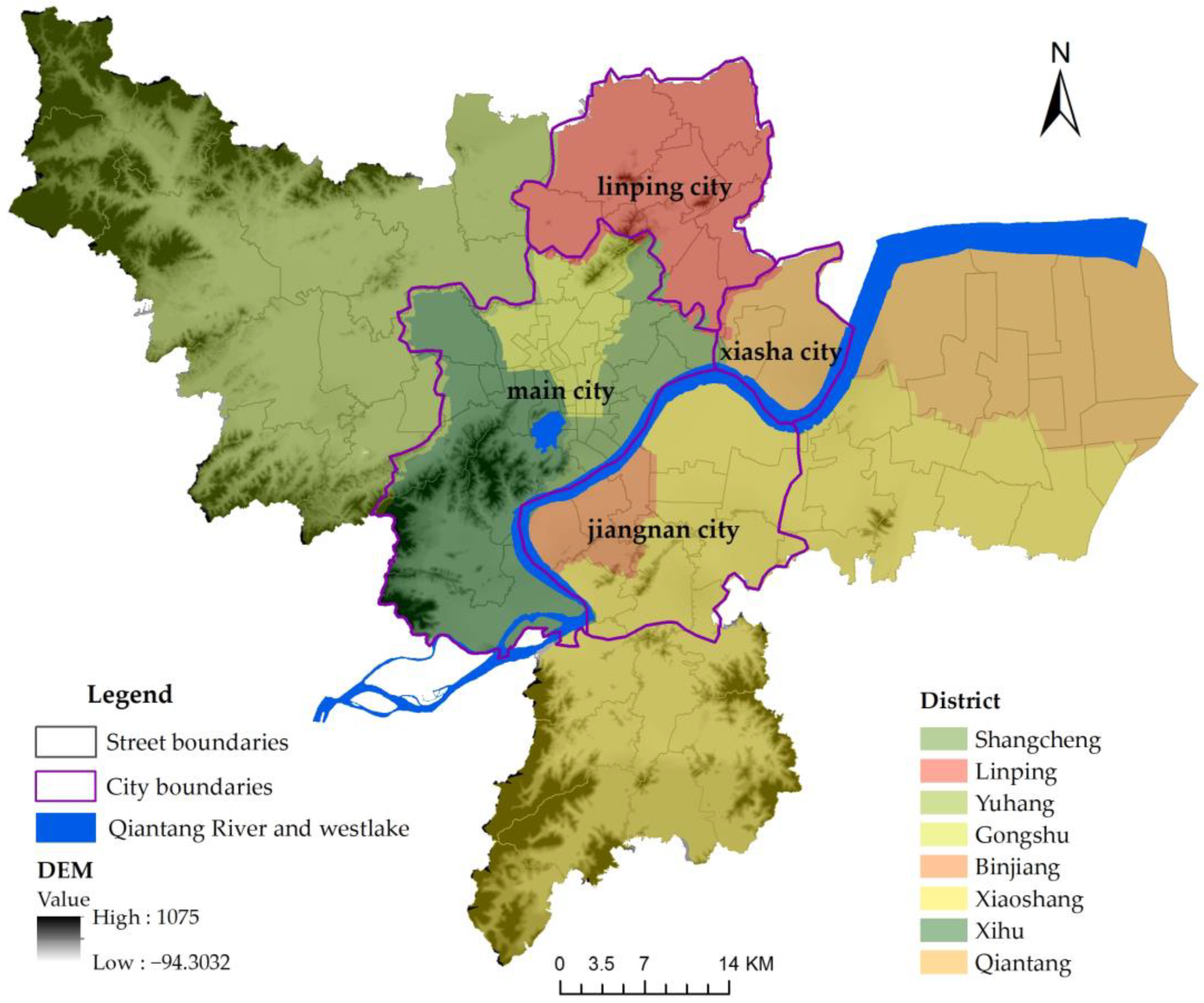
The adjustment of the administrative division has led to the promotion of the expanded Hangzhou city as one of the most important cities in the Yangtze River Delta. Before the reform and opening up of the country, Hangzhou’s urban administrative divisions included Shangcheng, Xiacheng, Jianggan, Gongshu, Xihu and its suburbs. In 1977, the suburbs and Xihu merged to form the new Xihu District, while in 1978, the eight areas of Gongshu District were merged. At that time, the three city blocks in Xihu and one city block in Yuhang County formed the Banshan district, creating an urban area of 430 hm2, including a state-scale scenic spot, the West Lake Scenic Area. With the protection of the natural scenery and historic cultural sites, the available land of Hangzhou City was almost 200 km2 after subtracting the West Lake Scenic Area (60 km2), mountains and waters. Therefore, land replacement and urban renewal were proposed to resolve the space development limit, as processes aiming to improve the functions of the core by restricting heavy industry, which has a certain advantage in the core. Heavy industry is largely located in inner suburban areas, such as the Banshan Heavy Industrial Zone, Gongchen Bridge Textile Industrial Zone, Xiangfu Bridge Light Industrial Zone, Liuxia Electronic Instrument Industry and Wangjiang Outside Food Industrial Zone. This strategy, which is simple, receives little resistance and requires less economic investment, but it also causes mixed city functions and environmental degradation. Taking the establishment of the Hangzhou Economic Development Zone (National Development Zone) and the Higher Education Zone in Xiasha in 1993 as an example, in May 1996, Sandun, Jiubao, Xiasha in Yuhang and Puyan Town, Changhe Town, and Xixing Town in Xiaoshan on the north bank of the Qiantang River were divided to create the urban area of Hangzhou so as to accelerate the development of the Xiasha Development Zone, solve the problem of insufficient space for urban development and connect the core and the zones to promote a diffusion effect by exploiting the point-axle theory.
The city thus expanded to 683 km
2 for the sake of future development based on the optimization of the industrial spatial layout and the preliminary enhancement of the urban function configuration. The embryonic form of the Xiasha city center took shape. However, the local government wanted to further expand the urban space. Due to a large amount of land available in the eastern plain of Hangzhou and the ability to undertake the transfer of industry from the main urban area, the entire areas of Xiaoshan and Yuhang were integrated into Hangzhou. The city has become an important metropolis in China, with an area of 3068 km
2(
Table 1). These adjustments of the administrative divisions, in conjunction with the revision of the city plan, enabled the city to truly enter the stage of eastward expansion, characterized by development along the river and development across the river, ensuring the formation of a spatial structure defined as “one core and three suburbs with six groups”.
There are three phases of urban master planning (1981–2000, 1996–2010 and 2001–2020) that are developed in response to the need for policies and urban growth. In Hangzhou’s development process, the determination of the orientation of the city and its development direction through urban planning played an important role in the change in its urban spatial form. At the beginning of the founding of the People’s Republic of China, Hangzhou was a convalescent city, and a large number of convalescent facilities were built around the West Lake Scenic Area. From the early 1960s to the mid-1970s, in the context of national industrial construction, the city was identified as a comprehensive industrial city. The expansion of the city to the north and east and the layout, with the West Lake as the core, led to many industrial construction projects within the city. Additionally, urban development was neglected on the north side of the Qiantang River, which is considered as the edge of the city, and the living and leisure functions and residences along the Qiantang River have not been well explored. After the reform and opening up of the country, the layout of the city was adjusted, and many industries gradually migrated from the old city. However, with the rapid development of Hangzhou, these industrial areas became surrounded and developed into an important source of pollution in the city [
35]. The high population density of the central city makes the development of urban transportation, housing and public facilities challenging. However, the government was aware of the importance of beautiful landscapes and historical sites in its search for a development strategy that could preserve its own identity. Hangzhou has revised its overall urban plan three times to adjust its development direction and optimize its spatial layout. In the first version of the master plan (1981–2000), the planned urban built-up area was 90 km
2. The city was designed to extend to the Qiantang River, with industry simultaneously being relocated to nearby areas and residential development being conducted towards the north along the Grand Canal [
36]. The second version proposed a new slogan “from the West Lake era to the Qiantang River era” [
37]. In Hangzhou, construction began on both sides of the Qiantang River, including the Xiasha Higher Education Park, Binjiang Higher Education Park, Olympic Sports Expo City, Baima Lake Eco-Creative City, Zhijiang New City and Zhijiang Cultural Grand Platform, to create the Qiantang River era, with the Qiantang River as the axis and the two banks as the wings. The plan guided the concentration of urban expansion on both banks of the Qiantang River and designed most residential areas as expanding to the edge of the inner city towards the industrial land located in the Jiangnan and Xiasha sub-cities. Meanwhile, the industrial area was relocated to Xiasha and other industrial concentrated areas, with the built-up area planned to total 197 km
2 after Xiasha and Binjiang were individually integrated. The third version of the Urban Master Plan (2001–2020) described the future urban spatial structure as “one main center, three subcenters, and six clusters”. All centers were designed to have their own identities, with the built-up area totaling 401 km
2. The evolution of the drafted plan demonstrates that the local government chose the polycentric strategy to manage urban development [
28]. Through the latest revision of the third edition of the city’s master plan, the urban form and spatial layout have been further optimized, and the multicenter level has been improved to form a multi-center network structure. The latest stage of the city planning of Hangzhou (2021–2035) continues the spatial pattern of multi-centered networked clusters. On the one hand, urban planning defines the direction and key areas of urban spatial development. On the other hand, the adjustment of administrative divisions promotes the urbanization of Hangzhou and the expansion of the urban development space.
Because of the naturally heterogeneous geographical conditions in Hangzhou, the city had to develop across the Qiantang River to obtain more land. Meanwhile, the adjustment of the administrative division led to the integration of the suburban land with the city at a low development cost to provide the necessary land for the urban extension. Moreover, the government and large organizations, which lead to the massive migration of enterprises and workers, will judge when and where to develop the city in the future through planning guidance and the market mechanism, which is the polycentric formation mechanism proposed by the urban system theory [
38]. Therefore, we can infer that Hangzhou already has the necessary conditions for polycentric structure formation.
4.3. The Spatial Layout of Internal Urban Elements
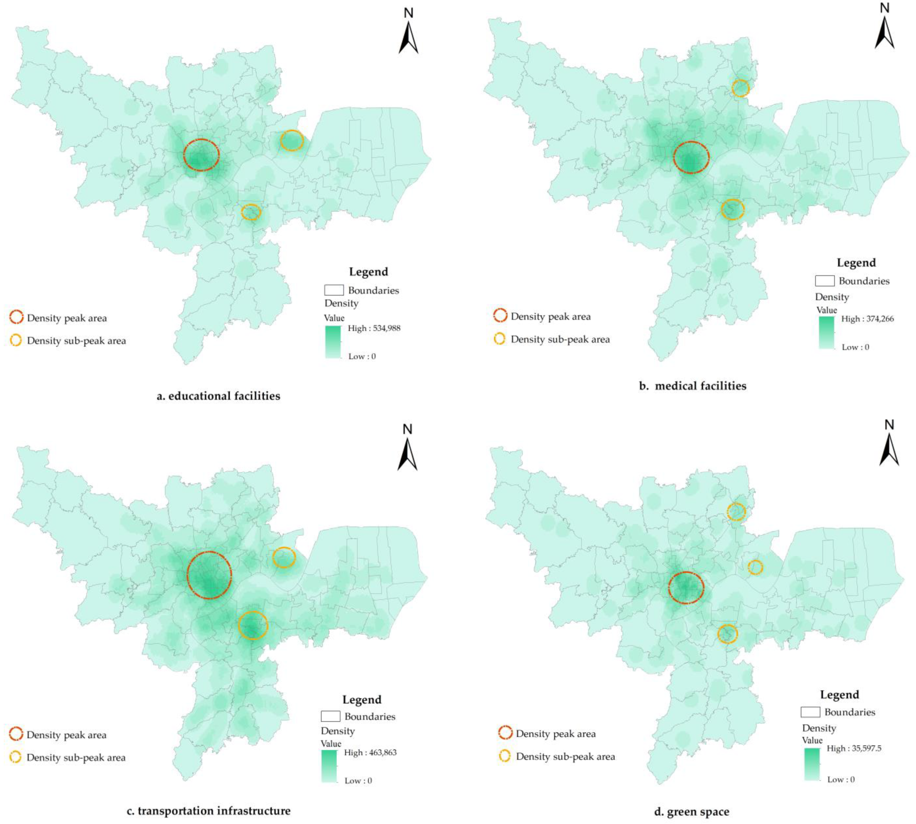
Macro-policies have promoted the economic development and rapid urbanization of Hangzhou, and the adjustment of the administrative districts has given the city enough space for its development. It has gradually moved towards a polycentric form under the guidance of planning. Therefore, does it also present polycentricity in terms of resource allocation within the city? We select transportation infrastructure and three types of public service facilities, representing education, medical care and green space, to analyze the formation and resource allocation efficiency of different centers. Additionally, the matching of polycentricity is laterally represented by the population density and nighttime lights.
4.3.1. Distribution of Urban Internal Space Elements
The change in the urban spatial structure is dominated by the transfer of internal spatial elements. The construction of transportation infrastructure and public service facilities is an important symbol of urban vitality and socioeconomic development. As investment projects, only after the spatial planning strategy is determined can they be implemented in accordance with the planned space. Therefore, the distribution of transportation infrastructure and public service facilities can reflect the spatial structure and resource allocation of the city. The analysis results are as follows (
Figure 3):
In general, regardless of the distribution of education, medical care, green space or transportation facilities in the old city, they form a large-scale cluster and are concentrated in the main center. Additionally, the strong main center and weak subcenter structure are still significant. At the same time, the four types of facilities have formed small gathering areas, with a certain intensity on the periphery of the city. Considering the spatial distribution of the educational facilities, they are concentrated on the Xixi and Lingyin streets around the West Lake in the older part of the city. Two small, concentrated gathering areas are formed in Xiasha, Puyan town and Chengxiang Street. Medical facilities are also clustered around the West Lake, with a lesser concentration along the Puyan, Changhe, Shushan and Chengxiang streets. In addition, there is a relatively weak gathering point around Linping Street and Nanyuan Street. The distribution of the transportation facilities is relatively more uniform, forming a highly concentrated area in the core urban area and expanding outward, gradually connecting with the built-up areas of Binjiang and Xiaoshan. Xiasha also forms a certain small concentration and is connected to the main city, with Jiubao at the connection point. The spatial distribution of the green space is centered on the main urban area, and minor peaks are formed around Chengxiang Street and Linping Street.
4.3.2. Matching Population Activities with Spatial Elements
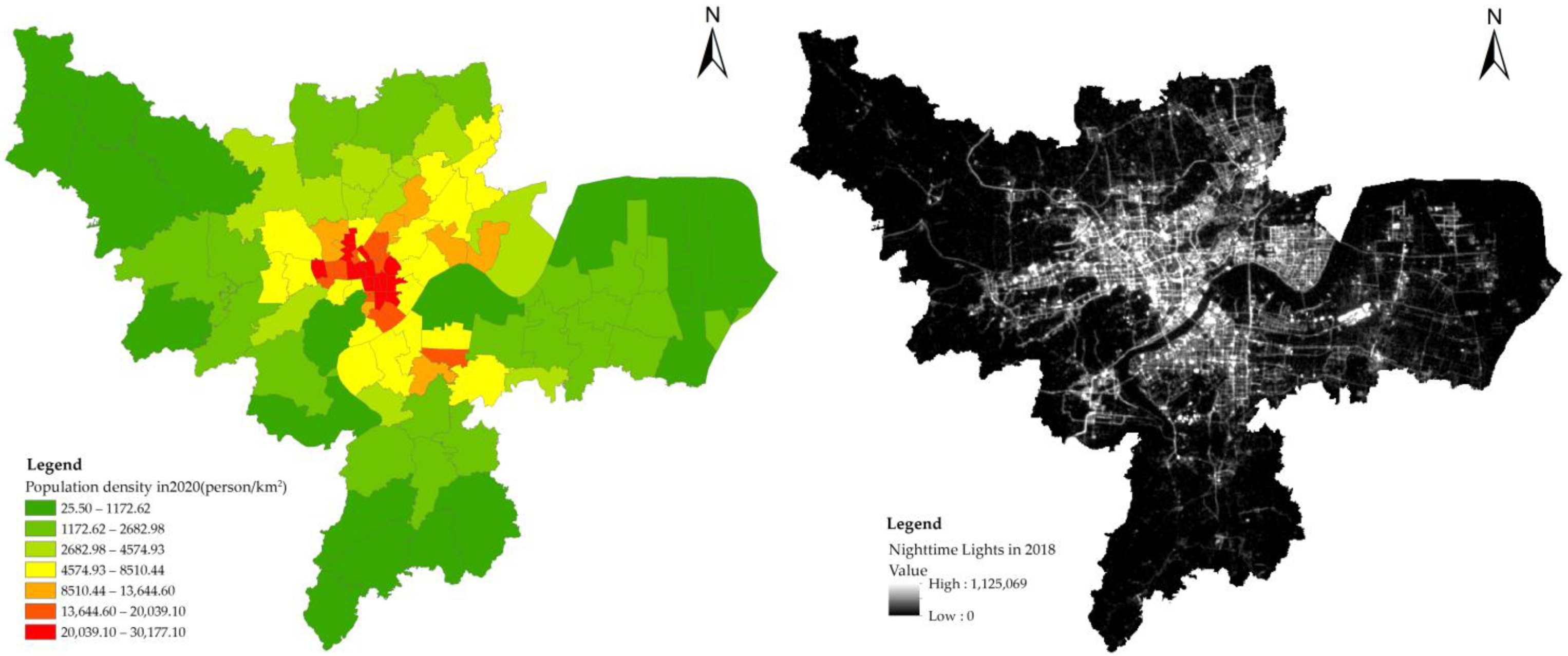
Transportation infrastructure and public service facilities reflect spatial strategy and planning allocation expectations. Additionally, the overall actual distribution of urban spatial elements can be combined with a more intuitive representation based on the population density and nighttime lights. The overall distribution of urban spatial elements can be compared and analyzed based on data reflecting the population density and nighttime lights. The results are shown in
Figure 4 below:
The population density of Hangzhou is highly concentrated in the main city, with a stratified circular layout, indicating that the central area of the city still has a strong attraction. The high-agglomeration area reflects the population in the main urban area, and the secondary agglomeration area mainly surrounds the high-agglomeration area and is in the core area of Xiaoshan, as well as Xiasha. The population density of the peripheral groups is not high. The population distribution basically shows a pattern of rapid growth along the east-west axis. Combined with the distribution of spatial elements, the eastern region was complemented by the accelerated construction of the university city in Xiasha, Dajiangdong New Town and Linjiang Industrial Park. The speed and intensity of development are obvious. The western region benefits from its natural ecological advantages and the construction base of the main urban area. The improvement of the functions of living, tourism, scientific research and education in the west, as well as the concentration of science and technology industries, have driven the great development of the Yuhang district. The population in the south is mainly concentrated in Binjiang. After the cross-river development strategy proposed by Xiaoshan and Hangzhou, Binjiang District was strengthened through the construction of Qianjiang New City and the National High-Tech Zone. At the same time, the cross-river corridor has been improved, and the south side of the Qiantang River has developed rapidly. The development in the north is mainly concentrated in the main urban area. The renovation and relocation of traditional industrial areas have enhanced the residential and recreational functions of this urban area but have failed to radiate to the surrounding areas, and the development of Linping is relatively weak. In general, the population and industrial development of the north-south axis are slightly weaker than that of those east-west axis, which has led to a large difference in the development of subcenters under Hangzhou’s polycentric strategy.
5. Discussion
5.1. Changes in Planning Tools Are the External Drivers of Hangzhou’s Polycentric Formation
As a typical public authority, planning tools have become an important method that is used by local governments to implement polycentricity. In line with most of the polycentric cities in China, the polycentric spatial structure of Hangzhou was gradually formed in response to the coordination of its administrative divisions and urban planning through macro-policy changes. After the determination of its polycentric spatial development strategy, the city’s overall plan was revised and adjusted several times, in addition to the regional master plan, industrial plan, new city conceptual plan, etc., to coordinate multiple administrative division adjustments. Several towns bordering the urban areas of Xiaoshan and Yuhang were included in the urban area, so that they now border the main urban area. As a result, they received stronger economic radiation effects and achieved economic development driven by the main city. The three towns (Xixing, Puyan and Changhe) that originally belonged to Xiaoshan were merged with the core city. On this basis, the Binjiang District was established, and the construction of the Binjiang Education Park and the High-Tech Park established “high-tech industry as the backbone”. The “high-tech, multifunctional, new technology city with integrated functions of commerce, trade, education, and residence” has gradually developed into a subcenter of the city, in accordance with the development of Xiaoshan, while the adjustment of townships such as Jiubao, Xiasha and the Hangzhou Economic and Technological Development Zone was directly connected to the main city, and the construction of the Xiasha Education Park and Industrial Park promoted the formation of Xiasha city.
5.2. The Polycentric Space Structure Is Formed by Typical Government-Oriented Development
According to the theory of polycentricity, government, market and social forces can be pluralistically involved on the formal institutional, governance structure, and resource allocation levels so as to jointly promote the formation of urban polycentricity. However, unlike studies that focused on market-led models or spatial patterns [
39,
40,
41], this paper finds that the government forces that allocate resources through planning guidance have dominated the polycentric development of Hangzhou in the formation and development of China’s polycentric cities. This government-led model may be a major factor in the development of Hangzhou’s polycentric structure and its characteristics. The construction of Qianjiang New City, Qianjiang Century City and public centers initiated the transformation of Hangzhou from the entire West Lake era to the Qiantang River era and promoted the shift in the focus of urban development. In addition, during the implementation of urban planning, the government’s policy orientation led to a great deal of municipal infrastructure construction, and the city’s internal resources and elements were continuously concentrated. The industrial enterprises, science and education parks and higher education parks in the city center have gradually expanded outward, which, to a certain extent, has promoted the development of the surrounding towns and the concentration of various industries within specific areas. At the same time, the improvement of the transportation infrastructure has shortened the space-time distance, which has not only provided industrial relocation convenience but also accelerated the ability of the subcenter to be influenced by the radiation from the main urban area. The scale was achieved through the construction of urban subcenters. However, the formation of this spatial structure depends on policy-led development, and the spatial distribution of the population still presents a strong concentration pattern in the core urban areas. The spatial distribution of the internal elements of the cities, such as transportation, education and medical care, also shows a trend of clustering in the main urban area, with small concentrations on the periphery.
5.3. The Achievement of Urban Polycentric Goals Requires the Guarantee of Optimal Resource Allocation
Distortions in resource allocation can lead to an inadequate spatial structure of polycentricity and affect the sustainable development of cities. As mentioned earlier, urban construction promotes population and industry clustering. However, this paper argues that the formation of a city’s polycentric structure cannot only start from the spatial agglomeration of the population and industry but should also take into account the institutional design and policies supporting the financial, production service and living service capacity. Otherwise, this will cause spatial misallocation and the inefficiency of resources. Comparing the distribution of infrastructure and the urban polycentric space structure, urban development is more dependent on types of infrastructure, such as transportation and medical care, while the construction of supporting facilities outside the city is lagging. In the central city, the agglomeration process of urban centers continues, discrete development is weak, and the urban polycentric spatial structure is underdeveloped. This means that in the formation of the polycentric structure, it is difficult for the external driving forces to fully form the functions of each center. Polycentric development policies emphasize the potential of endogenous drivers. Thus, it is necessary to cooperate with the corresponding institutional design and support systems to guarantee the participation of more market players and promote the flow of urban factors. This can encourage the internal functions of suburban areas and clusters to gradually improve themselves through economic development. At the same time, with the policy tools, more production services and living service facilities are laid out here so as to realize functional improvement through the combination of endogenous drivers and exogenous forces.
6. Conclusions
This research builds an analytical framework that explores the internal development mechanism linking institutional and policy changes to urban internal factors. It analyses the evolution of Hangzhou’s polycentric space according to three dimensions: macro-institutions, planning strategies and resource allocation. The evaluation of the performance of the central space form provides additional ideas. The research results show that (1) the evolution of polycentric spatial structures has many aspects, including the political and institutional background of urban development, the government’s intentions for urban development, the design of supporting systems in the implementation of the plan, the decision logic of the population and the space scale, and the changes in the patterns of the stakeholders involved in urban construction. (2) On the microscale, inside the city, the polycentric structure formed by exogenous forces, such as planning guidance and government forces, is weak. The main urban area of the city is still clustered, the subcenters are insufficiently developed, and the peripheral groups are underdeveloped. (3) The matching of population activities and spatial elements demonstrates that the development strategies of the space and population are often dissociated with the actual development. Hangzhou, which implemented the polycentric development strategy, is still in the stage of agglomeration development, failing to achieve a balance between its population and industry. Our findings, on the one hand, can be taken as an important reminder for urban planners and policymakers. Given the lack of a comprehensive evaluation of the industrial structure, financial capacity, production service capacity, living service capacity and the corresponding support systems, the promotion of exogenous forces can quickly form a polycentric shape, but it is sometimes challenging to achieve functional changes. Therefore, the cultivation and promotion of endogenous market forces are important aspects that China’s urban polycentric space development strategy must strengthen in the future.
The introduction of Williamson’s social science research framework into polycentric research combines macro-institutional changes, policy tools and resource allocation in the context of transitional China, providing a new perspective for the interpretation of the spatial evolution mechanism of polycentric cities. Unlike previous studies on the spatial evolution of polycentricity from a single perspective [
39,
42,
43], such as functional and morphological measures or macro-contextual changes, this framework establishes links between multiple perspectives on spatial evolution, combining institutional reforms, institutional transformations, etc., with the local government planning interventions and policy support and the spatial layout of elements within cities, which better illustrates the important roles of institutional reform and institutional transformation in the urban spatial reconfiguration in transitional China and also show that, in this macro-context, local governments are given the ability to mobilize resources, become an important force driving urban spatial restructuring and optimization, and influence urban resource allocation, revealing that the formation of urban polycentricity in China is the result of the interaction between government planning interventions and market forces. The integrated consideration of localized social contexts and intra-city elements avoids the isolation of polycentric cities on any particular level, as observed in previous evaluations. With the large-scale spatial expansion and spatial reconfiguration of Chinese cities providing realistic conditions for polycentric research, it is important to construct a localized research framework and theoretical paradigm. In addition, the three-level analytical framework established in this study better reflects the formation of polycentricity in Hangzhou. The interactions between these three levels, along with the actors guiding policy design and decision making, ultimately affect the outcomes of urban polycentric development and are consistent with the development characteristics of polycentric cities in transitional China. Additionally, the applicability of the framework to China’s polycentric cities was verified. Thus, this framework can be applied to other polycentric cities, rather than provincial capitals or mid-sized cities alone. Moreover, although, on the resource allocation level, we used different urban elements for our evaluation, all these measures were quantified from a morphological perspective. For different city characteristics, social, cultural and other urban elements can be considered in the framework’s application. Further research should be undertaken in this regard.


